THURSDAY i’m lovin’ it!
HIGH 93ºF LOW 82ºF
The Tribune Established 1903
24/7 BREAKING NEWS ON TRIBUNE242.COM
Biggest And Best!
OBITS
VOLUME:114 No.199, SEPTEMBER 7TH, 2017
THE PEOPLE’S PAPER:$1
OFFICIA
CL ASSIFIEDS TRADER: CARS, CARS, CARS - AND TECH!
INSIDE
L SOUR CE
PREPARE FOR THE WORST
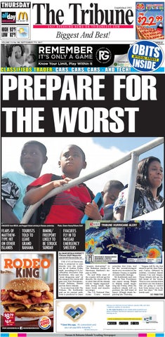
EVACUEES from MICAL and Ragged Island arriving in Nassau yesterday.
FEARS OF MATTHEWTYPE HIT ON OTHER ISLANDS
TOURISTS TOLD TO LEAVE GRAND BAHAMA
BIMINI/ FREEPORT LIKELY TO BE STRUCK SUNDAY
Photo: Shawn Hanna/Tribune Staff
TRIBUNE HURRICANE ALERT
EVACUEES FLY IN TO NASSAU EMERGENCY SHELTERS By SANCHESKA DORSETT Tribune Staff Reporter sdorsett@tribunemedia.net THE EYE of Hurricane Irma is projected to pass directly over the northern tip of Andros Friday night, according to US Accuweather forecaster Dan Kottlowski, who said the “most dangerous side” of the category five storm will pass over New Providence, Grand Bahama, Bimini and the Berry Islands. In an interview with The Tribune, Mr Kottlowski said on its current path, Irma is predicted to cause
“massive destruction” to The Bahamas similar to Hurricane Matthew’s impact in 2016. He said while most of the country will not get hit directly, the storm will be so close that all the islands will be “highly impacted” with strong winds, high water levels and massive sea surges. The US National Hurricane Centre warned
yesterday that Irma, tied for the second-strongest storm ever recorded in the Atlantic Ocean, is capable of catastrophic damage. Mr Kottlowski said residents in New Providence can expect strong 70mph to 80pmh winds beginning late Friday, while the southern islands will experience the full brunt of Irma’s 185mph winds beginning late Thursday.
8 79
MEAL
6 49
SANDWICH
Incl. VAT
WWW.BURGERKING.BS
/BURGERKINGNASSAU
Nassau & Bahama Islands’ Leading Newspaper
“Inagua will be the first island to get hit, then Turks and Caicos, followed by Acklins, Crooked Island, Samana Cay and Inagua. Those islands will get the full brunt of the storm. This is a very serious storm and there are two features that are going to control how Irma moves over the next two days,” Mr Kottlowski said. SEE PAGE FIVE