WEDNESDAY, MAY 6, 2015
Serving Polk County’s St. t Croix C i Valley V ll since i 1897
VOL. 127 NO. 40
www.osceolasun.com $1.00
SPORTS: Osceola golfers have busy week. P. 10
Acre-Kendall pleads not guilty Judge updates conditions of bond BY SUZANNE LINDGREN EDITOR@OSCEOLASUN.COM
Levi Acre-Kendall pleaded not guilty at his a arraignment h hearing, May 44. Acre-Kend dall, 19, C Cambridge, M Minn. stands a accused of ffirst-degree Acre-Kendall Acre Kendall r reckless homicide in the fatal stabbing of Peter “Pete” Kelly, April 14. If convicted of the Class B Felony, Acre-Kendall could face up to 60 years in prison. Although Acre-Kendall’s attorneys, Eric Nel-
son and Doug Hazelton of the Minnesota law firm Halberg Criminal Defense, did not explicitly claim self-defense, statements made in the criminal complaint and during the preliminary hearing have led observers to conclude that a case for self-defense will be made at trial. During the fifteen-minute hearing, Attorney Nelson asked Judge Molly GaleWyrick to reduce the defendant’s bond from $125,000 to $75,000. The defense also asked Judge GaleWayrick to revise the conditions of Acre-Kendall’s bond, allowing him to stay in Minnesota with location-monitoring devices, except for future SEE ACRE-KENDALL, PAGE 10
June 3 preliminary hearing scheduled for Christensen BY CHELSEA EMORY-BOYD CEMORY@THEAMERYFREEPRESS.COM
Darryl Christensen is free on a $10,000 signature bond following his i initial court a appearance M May 1. A p preliminary h hearing on c charges of five counts o of second Christensen Ch i t d degree sexual assault by correctional staff is scheduled for June 3. Christensen is represented by Aaron A. Nelson. Robert John Kaiser, Jr. is the Prosecuting Attorney. The responsible official is Judge Eugene Harrington. “We would waive any further reading of the criminal complaint,” Nelson said. “(Christensen) is aware of the charges as well as the maximum penalties for each of those five charges.” Judge Harrington stat-
ed that the maximum penalty for each of the five counts of felony second-degree sexual assault is $100,000, and up to 25 years in jail. For the record, Christensen stated his age, address, how long he has lived at his current address, marital status, how many children he has, if his children are residents of Polk County, how long he has lived in Northwest Wisconsin, his employment status and where he is employed. Christensen’s bail conditions include no contact with persons indicated by initials mentioned in the criminal complaint and a $10,000 signature bond. “Mr. Christensen, you need to sign the bail bond,” Harrington said. “Read the bail conditions on a daily basis, so that you understand what they are and stay within the confines of those conditions.”
NEWS 715-294-2314 editor@osceolasun.com
Smart Cartography Scout builds dynamic map BY SUZANNE LINDGREN EDITOR@OSCEOLASUN.COM
A stand-alone paper map of the trails at Standing Cedars Community Land Conservancy was never going to fulfill its purpose for long. “The trail system is not static,” said Steve Rassler, president of Standing Cedars’ board. “It changes. Some trails we realize don’t get used enough to be worth maintaining, or maybe they go through sensitive areas that we’d rather reduce traffic to. Other trails we decide there’s a new trial needed through a given area.” And yet, some kind of trail map was sorely needed. “I’ve had a few reports from people who were out walking,” said Rassler. “They get out there and there aren’t any signs and they lose track of directions and they, quite frankly, get lost. I believe
that because I’ve done it myself, more than once.” So, when a tech-savvy Boy Scout approached Rassler with a proposal to map the conservancy’s trails for his Eagle Scout project, Rassler jumped at the chance. Together, they came up with a scheme that would match the ever-changing trail system with a malleable map. The Scout, Ben Jacobs of Osceola, has had a longstanding interest in computers and electronics. He first envisioned digitizing Standing Cedars’ existing maps into an app for visitors to use, but soon realized there was a small problem: the maps were out of date. So he proposed making new ones instead, using his programming skills to superimpose trail routes onto maps created by Google. “I’ve always been interested in software engineering and have taught myself programming,” said Jacobs, who is homeschooled. “Google Maps has a way for program-
SUBMITTED
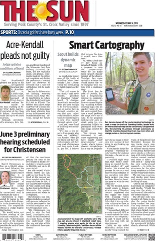
A screenshot of the map with a satellite view. The map can also be shown in standard street view. “I imagine anyone who wants to hike or ski at Standing Cedars using this,” said Ben Jacobs of the website he built for the land conservancy. “I made it to be easy for the public to use.” ADVERTISING 715-294-2314 sales@osceolasun.com
PUBLIC NOTICES 715-294-2314 sales@osceolasun.com
SUBMITTED
Ben Jacobs shows off the route-tracking technology he used to map the trails at Standing Cedars. Jacobs built an interactive trail map for the conservancy’s Engelwood site, documenting his process through screencasts so that the Standing Cedars Board can map more sites and change routes as the trail system evolves. mers to use maps in their own way instead of just going in and looking up an address.” When Rassler heard the proposal — especially Jacobs’ method for making the maps — he saw an opportunity. “I realized right away that that wasn’t something we wanted the finished product of,” said Rassler. “We wanted the process for use as a tool that we could continue to use ourselves even after Ben’s project was done and Ben, bless his heart, had gone on with the rest of his life.” The two decided Jacobs would create a demonstration map of Standing Cedars’ Engelwood site and supply the board with training videos showing how he’d done it. After that, it was up to Jacobs to figure out how to track the trails and build the maps. “I researched different ways to map with GPS so I could upload the information to my computer,” he said. “I found out the best way was with old smartphones.” Using an app called MyTracks, Scouts from Jacobs’ troop walked the
SUBSCRIPTIONS 715-294-2314 office@osceolasun.com
trails of Engelwood last November. Because the app tracks every step, each group had to know in advance exactly where it was going. Rassler had given Jacobs a reference map with trails Standing Cedars wanted marked and those it didn’t. Jacobs used it — along with his own on-the-ground research — to write instructions for the other troop members to follow as they walked the routes. The day was a success, and Jacobs went home with enough data to start building his map. “Once I had the tracks, I put them on computer,” said Jacobs. “I built the map over the winter … and wrote all the code for the website myself.” The 200-line code uses Google’s My Maps to display the routes Jacobs’ troop tracked last year. The map features additional points of interest that, when clicked, reveal information about specific locations through photos or text. Jacobs finished the map in March, and celebrated his seventeenth birthday shortly afterward. While SEE MAP, PAGE 8
BREAKING NEWS, UPDATES Whenever, wherever you are! Scan me with your smartphone