8 minute read
Focus on Maintenance & Operations: Worcester


Worcester partners on LIDAR pilot program
By DENISE FEDOROW | The Municipal
The city of Worcester (pronounced Wooster), Mass., officials took a chance on some recent college graduates and their new technology to pilot a program to improve infrastructure using LIDAR technology.
Former Worcester Polytechnic Institute students approached the city with the idea to use LIDAR to identify potholes, according to department of public works Commissioner Jay Fink.
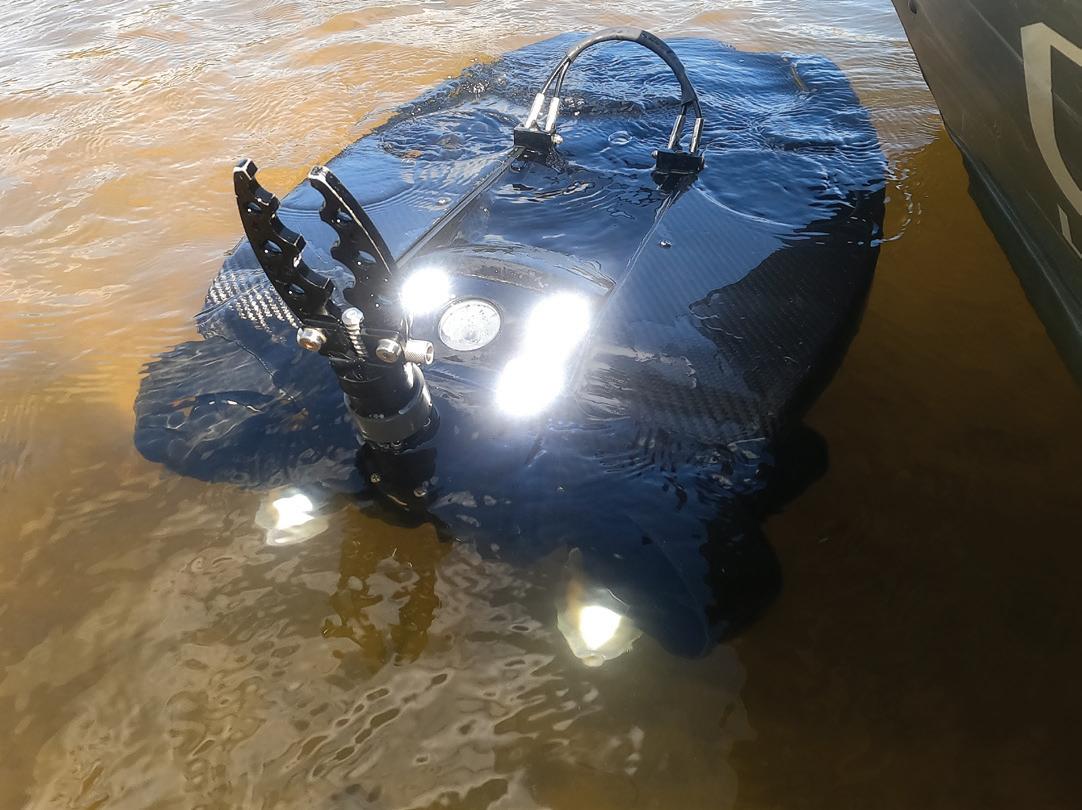
The former students, Daniel Pelaez, Noah Budris and Noah Parker, had graduated WPI in 2020 and formed their company, Roadgnar, that summer. They’d started working on the concept two years prior during their junior year and worked on it part time until they graduated and then “went for it.” The result was their Infrascan sensor.
“It all started with problems we saw going to school in New England. The deterioration of the infrastructure — roads, sidewalks, etc. — and we wondered what towns and cities were doing to manage their infrastructure,” Pelaez said. “We were learning about this technology at the same time, and we thought we could use it and make everyone’s lives easier.”
Fink said the group approached the city with a pilot program to read road surfaces, and officials agreed to have them use the technology on the streets in Hope Cemetery.
“The reason we chose the cemetery is because it looks like a street, acts like a street as far as computer simulation but with less traffic and more latitude and the ability to scrutinize the information,” he said. “They surveyed the streets, and it shows where the flat plane of the street would be and then any deviations — any imperfections representing potholes or sections of asphalt missing or sunken casting, for example.” ABOVE: This 3D rendering is a mapping image of a city street using Roadngar’s Infrascan LIDAR technology. Roadgnar CEO Daniel Pelaez explained the red lines on the image are the paint markings on the road. (Photo provided by Roadgnar)
“The overall goal is that this technology is very mobile so with the futuristic thought that we could affix the equipment on our vehicles like a street sweeper or trash truck so as it’s going up and down every street it could be gathering data for us simultaneously,” Fink said.
If that kind of information were available, it could update what the city has, show where the defects are and improve its records on road conditions, which would help the city make resurfacing project decisions.
The city officials said they weren’t aware of any other circumstance where LIDAR technology had been used in Worcester prior to this point.
Fink explained historically what the city had done was hire a firm to survey the streets and give a pavement condition index,
ranking the streets to prioritize for pavement treatment or reconstruction “as part of an overall program for upgrading and maintaining streets for drivability.”
“Just like every municipality in Massachusetts, our needs far outweigh the available funding,” Fink said. “We’re forever computing how much money we can put out; therefore, we want to prioritize certain streets, especially if they’re in serious need of reconstruction. A tool like this can allow you to narrow down which streets you really should be considering.”
The pilot started in September 2021, and workers went through frequently and created a roadway map of the cemetery with the LIDAR technology. They created a colorcoded map showing which roads were in good conditions, which were in poor condition and which ones really needed a lot of work.
When asked how the technology can tell the location of a pothole, Deputy Commissioner of Department of Public Works Bill Coyle said the three-dimensional image shows depressions in certain areas. Since the technology only shows the surface, Fink said determining where a pothole may later develop might prove more difficult. While the image shows depressions, it may miss a stress fracture that might create a pothole.
LIDAR technology
LIDAR or light detection and ranging mapping has become an established method for collecting very dense and accurate elevations data for landscapes, shallow water areas and project sites. LIDAR is similar to radar but uses laser light pulses instead of radio waves.
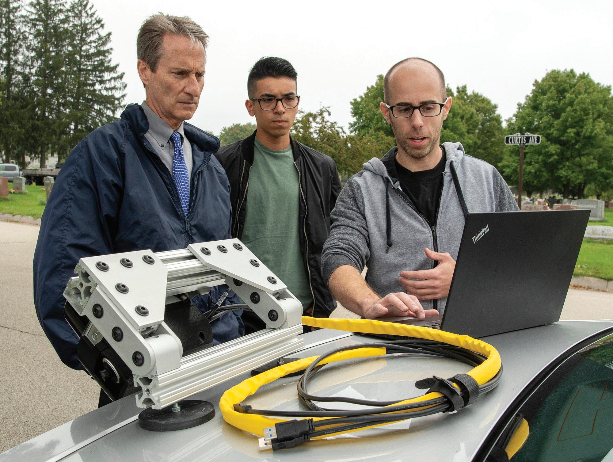
Eric Batista, assistant city manager and office of urban innovation, said Worcester City Manager Edward Augustus Jr. was “very From left, Worcester, Mass., Department of Public Works Commissioner Jay Fink listens to Roadgnar Founder and CEO Daniel Pelaez and lead scientist Bryan Licciardi explain how LIDAR works as the city began a pilot program with the company in early September. (Photo courtesy of Worcester Telegram & Gazette)
excited about this opportunity for us to be able to analyze our streets in this very technologically advanced way.”
Batista said the city didn’t pay for the pilot program but said the department of public works will assess the outcome of the data review and determine whether this is something it wants to expand. He said if the city goes farther, it would order a certain amount of sensors to place on city vehicles, and the Roadgnar techs would analyze and assess the data.
Batista said he imagined the city would enter a three- or five-year agreement with Roadgnar, and it would lease the equipment versus purchasing it. As the trucks drive around the city, they would also capture data, reducing costs for the city in time and labor.
Coyle said the city has 1,000 lane miles “so it’s a tremendous amount of roadway to check — if the data (collected by Roadgnar) proves to be accurate, it could be beneficial.”
At the time they spoke to The Municipal, the field work had been completed, and the city was waiting to receive the data.
“So we can compare with the other information we have to see how well it compares to our grading system so we’re comfortable that the data we’re getting is accurate,” Coyle said.
Walter Bird, media relations specialist for the office of city manager, said the LIDAR information can be integrated in the city’s GIS system. “This could lead to a (GIS framework) where all this information helps to inform most of our day-to-day data in that framework.”
Coyle said the biggest benefit “that jumped out right away was the ability to map potholes.”
He said they show up as blue-shaded areas. Currently, Worcester has a system where residents call in to report potholes; however, not all potholes get reported, so there may be some local streets that are overlooked.
“Having an inventory of potholes and knowing where they are so we can target them would be helpful,” Coyle said, adding what makes Roadgnar different is the fact that its equipment can be attached to the city’s vehicles.
Future uses
While the pilot had a narrow focus on potholes, city officials reported they can see the potential to use the LIDAR technology for sidewalks, transportation location of hydrants and street signs.
“It could lead to a real conversation about transportation — walkability, trees. (It’s) something exciting that could help inform design and planning,” Batista said.
Fink said Worcester is taking it “one step at a time” and it’s determining how the technology can work “for helping in doing what we have to do — maintain roadways.” Roadgnar’s lead scientist Bryan Licciardi explains how the company’s LIDAR technology will work to map out potholes in the city of Worcester, Mass., this past September. The city entered a pilot program with the company founded by area college graduates. (Photo courtesy of Worcester Telegram & Gazette)

Pelaez noted, “LIDAR can manage anything in the physical world—pavements, sidewalks, trees and traffic signs are most important in government.”
It can benefit operations. For example, inventorying signs can be very labor intensive, with most municipalities conducting such surveys in the spring and fall. Pelaez said the LIDAR technology can map the location of signs and scan for any graffiti or missing signs, etc.
Other uses, according to Pelaez, could be storm drains, manhole covers and handicap ramps. Additionally, utility companies are showing interest in using the technology to manage power lines.
“If branches are growing into power lines, they can take care of it before a storm and stop potential power outages,” Pelaez said.
Similarly, cities could use the technology to create tree inventories to track how they’re growing over time — if they’re growing too quickly over a walkway, for example.
Worcester is working on becoming a Smart City, and Batista said participating in this pilot program goes along with that goal.
“It allows us to be known as a city open to new technologies, by utilizing those solutions to improve our day-to-day service,” Batista said. “We have great institutions here with WPI and Clark University, and we are open to those who are coming up with new, innovative ways to provide quality service to our residents.”
He added, “We’re always open to allow folks to come in and test and share — it encourages students and small businesses to grow and develop in the city.”
Coyle said he’d “certainly encourage others to look at innovative ways” of operating, and while Worcester doesn’t have all the data yet, he would encourage other municipalities to look into it as well.
Batista summed it up by saying, “I think, as a municipality, we should be looking at ways to improve service to residents. It’s our responsibility to be more innovative at all levels. The more we adapt, the better it is for residents — especially with technology, which changes so frequently and quickly.
“It’s important that we, as municipal employees, constantly have open doors and evaluate our performances, our work and utilize resources,” he said. “For example, our WPI students live and work in our city. Why not utilize our human capital to provide solutions to our community’s dayto-day challenges?”