


Hills District Pony Club, Castle Hill
Report prepared by Narla Environmental for The Hills Shire Council
May 2023
Report: Ecological Constraints Assessment Report – Hills District Pony Club, Castle Hill
Prepared for: The Hills Shire Council
Prepared by: Narla Environmental Pty Ltd
Project no: HILLS5
Date: May 2023
Version: Final v2.0
all© Narla Environmental Pty Ltd
Disclaimer
The document may only be used for the purposes for which it was commissioned and in accordance with the Terms of the Engagement for the commission. This report and all information contained within is rendered void if any information herein is altered or reproduced without the permission of Narla Environmental. Unauthorised use of this document in any form whatsoever is prohibited.
This report is invalid for submission to any third party or regulatory authorities while it is in draft stage. Narla Environmental Pty Ltd will not endorse this report if it has been submitted to council while it is still in draft stage. This document is and shall remain the property of Narla Environmental Pty Ltd. That scope of services, as described in this report, was developed with the client who commissioned this report.
Any survey of flora and fauna will be unavoidably constrained in a number of respects. In an effort to mitigate those constraints, we applied the precautionary principle described in the methodology section of this report to develop our conclusions. Our conclusions are not therefore based solely upon conditions encountered at the site at the time of the survey. The passage of time, manifestation of latent conditions or impacts of future events may require further examination of the project and subsequent data analysis, and re-evaluation of the data, findings, observations and conclusions expressed in this report. Narla Environmental has prepared this report in accordance with the usual care and thoroughness of the consulting profession, for the sole purpose described above and by reference to applicable standards, guidelines, procedures and practices at the date of issue of this report. For the reasons outlined above, however, no other warranty or guarantee, whether expressed or implied, is made as to the data, observations and findings expressed in this report, to the extent permitted by law. This report should be read in full and no excerpts are to be taken as representative of the findings. No responsibility is accepted by Narla Environmental for use of any part of this report in any other context. The review of legislation undertaken by Narla Environmental for this project does not constitute an interpretation of the law or provision of legal advice. This report has not been developed by a legal professional and the relevant legislation should be consulted and/or legal advice sought, where appropriate, before applying the information in particular circumstances. This report has been prepared on behalf of, and for the exclusive use of, the client who commissioned this report, and is subject to and issued in accordance with the provisions of the contract between Narla Environmental and the client who commissioned this report. Narla Environmental accepts no liability or responsibility whatsoever for, or in respect of, any use of, or reliance upon, this report by any third party. Narla Environmental Pty Ltd has completed this assessment in accordance with the relevant federal, state and local government legislation as well as current industry best practices including guidelines. Narla Environmental Pty Ltd accepts no liability for any loss or damages sustained as a result of reliance placed upon this report and any of its content or for any purpose other than that for which this report was intended. Intellectual Property Laws Protect this document: Copyright in the material provided in this document is owned by Narla Environmental Pty Ltd. Narla Environmental reserves the right to revoke this report, its content and results derived during the scope of work. Third parties may only use the information in the ways described in this legal notice:
Temporary copies may be generated, necessary to review the data. A single copy may be copied for research or personal use. The documents may not be changed, nor any part removed including copyright notice. Request in writing is required for any variation to the above An acknowledgement to the source of any data published from this document is mandatory

Works for this report were undertaken by:
Staff Name Position
Chris Moore
BBioCon
Jack Tatler
BSc Hons PhD
Draft v1.0
Draft v2.0
Final v1.0
Final v2.0
Narla Environmental General Manager/ Senior Ecologist
Principal Ecologist
Ecological Constraints Assessment Report – Hills District Pony Club, Castle Hill
Ecological Constraints Assessment Report – Hills District Pony Club, Castle Hill
Ecological Constraints Assessment Report – Hills District Pony Club, Castle Hill
Ecological Constraints Assessment Report – Hills District Pony Club, Castle Hill
19/09/2022
30/11/2022
06/03/2023
15/05/2023
Chris Moore
Chris Moore
Chris Moore
Chris Moore
Table 1. Relevant legislation and policy
Table 2. Weather conditions recorded at Parramatta NSW (station 066124) preceding and during the site assessments (site assessment dates in bold). ............................................................................................................
Table 3. Description of Sydney Turpentine Ironbark Forest.
Table 4. Description of Sydney Hinterland Transition Woodland.
Table 5. Description of Coastal Sandstone Ridgetop Woodland.
Table 6. Description of Historically Cleared.
Table
Table
Figure 6. Preferred concept design for the former Pony club Site, Option 2d (Hills Shire Council 2022).
Acronym/ Term Definition
BAM Biodiversity Assessment Method
BC Act New South Wales Biodiversity Conservation Act 2016
BDAR Biodiversity Development Assessment Report
ECA Ecological Constraints Assessment
DA Development Application
Development
The use of land, and the subdivision of land, and the carrying out of a work, and the demolition of a building or work, and the erection of a building, and any other act, matter or thing referred to in section 26 that is controlled by an environmental planning instrument but does not include any development of a class or description prescribed by the regulations for the purposes of this definition (Environmental Planning and Assessment Act 1979).
DEC Department of Environment and Conservation
DPE Department of Planning and Environment (formerly DPIE)
DPI Department of Primary Industries
DPIE Department of Planning, Industry and Environment (now DPE)
EP&A Act Environmental Planning & Assessment Act 1979
EPBC Act Environment Protection and Biodiversity Conservation Act 1999
FFA Flora and Fauna Assessment Report
ha Hectares
km Kilometres
LGA Local Government Area
Locality
The area within a 5km radius of the Subject Land. The same meaning when describing a local population of a species or local occurrence of an ecological community.
m metres
mm millimetres
HDCP The Hills Development Control Plan 2012
HLEP The Hills Local Environmental Plan 2019
PCT Plant Community Type
SEPP State Environmental Planning Policy
Subject Land The area assessed as part of this report (Hills District Pony Club (Lot 224/-/752020)
TEC Threatened Ecological Community
Threatened species, populations and ecological communities
Species, populations and ecological communities specified in Schedules 1 and 2 of the BC Act 2016


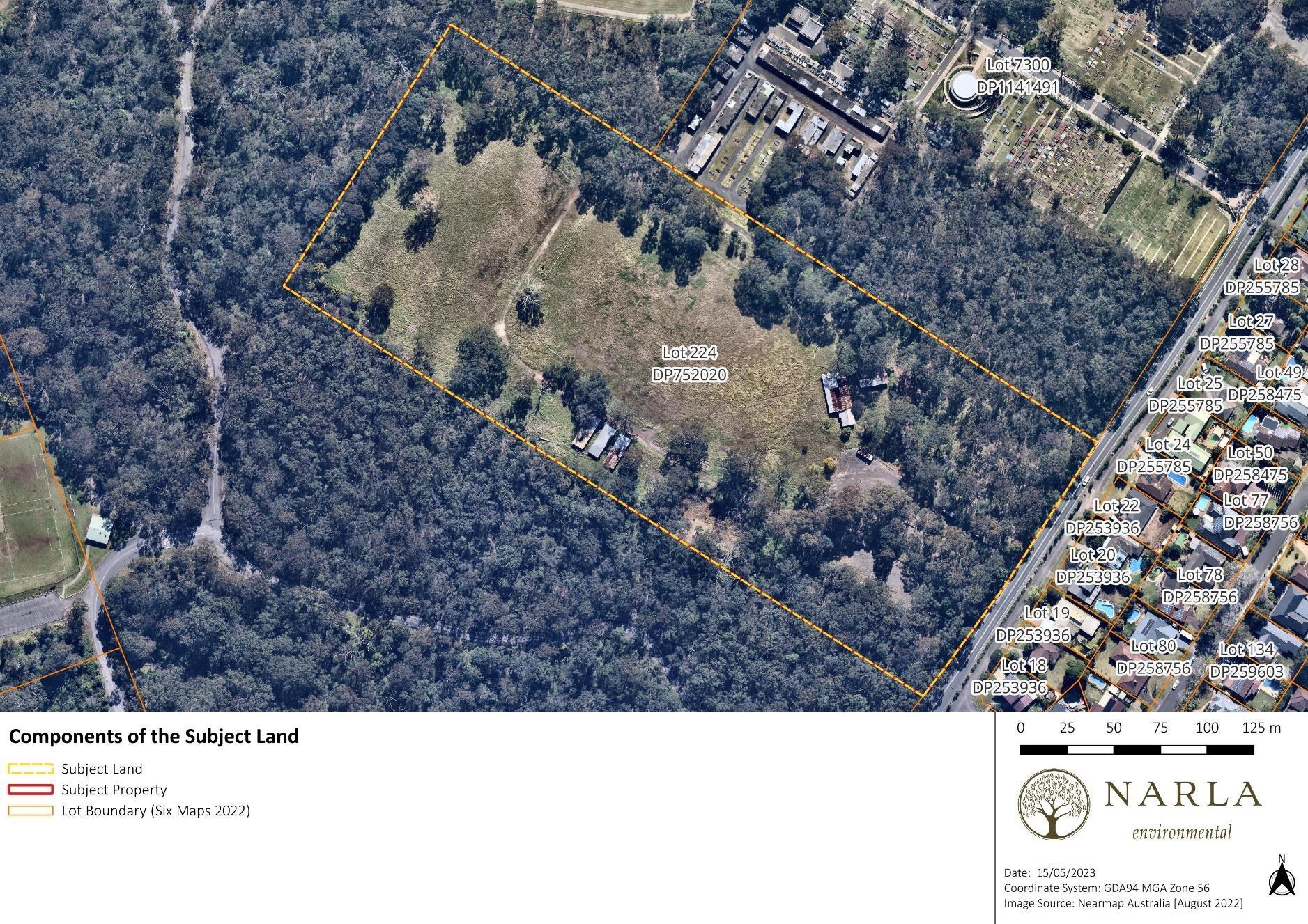
Narla Environmental Pty Ltd (Narla) was engaged by The Hills Shire Council (‘the proponent’) to prepare an Ecological Constraints Assessment (ECA) to determine the biodiversity values, development potential and ecological constraints at the Hills District Pony Club (Lot 224/-/DP752020), hereafter referred to as the ‘Subject Land’ (Figure 1).
It is understood that the proponent seeks to develop the Subject Land as a sporting and recreational facility and therefore wishes to determine the ecological values on site to enable an environmentally sensitive design. This report will focus on biodiversity values and constraints associated with environmental planning instruments, as well as Threatened Ecological Communities (TECs) and threatened species listed under the Biodiversity Conservation Act 2016 (BC Act) and the Environmental Protection and Biodiversity Conservation Act 1999 (EPBC Act).
The Subject Land is located on the western side of Gilbert Road, with Castle Hill Cemetery and Field 1 Fred Caterson Reserve to the north and remnant bushland to the west and south. The Subject Land is located with The Hills Local Government Area (LGA) and covers an area of approximately 6.8ha Currently, it is mostly cleared of native vegetation except for the peripheries and an area along the eastern boundary. Historical imagery indicates the Subject Land has existed in its current state since 1970 (or before).
The Subject Land is flat with an elevation ranging from 108m above sea level (asl) in the north-west to 91m asl in the south-west (Google Earth 2022) The Subject Land is situated on both the Glenorie and Hawkesbury soil landscapes as indicated on the Soil Landscapes of the Sydney 1:100,000 Sheet (DPIE 2020)
The Glenorie landscape is characterised by undulating to rolling low hills on Wianamatta Group shales. This soil landscape is underlain by Wianamatta Group Ashfield Shale and Bringelly Shale formations. The Ashfield Shale is comprised of laminite and dark grey shale. Bringelly Shale consists of shale, calcareous claystone, laminite, fine to medium grained lithic-quartz sandstone (DPIE 2020)
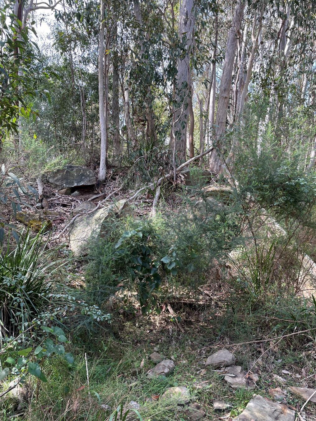
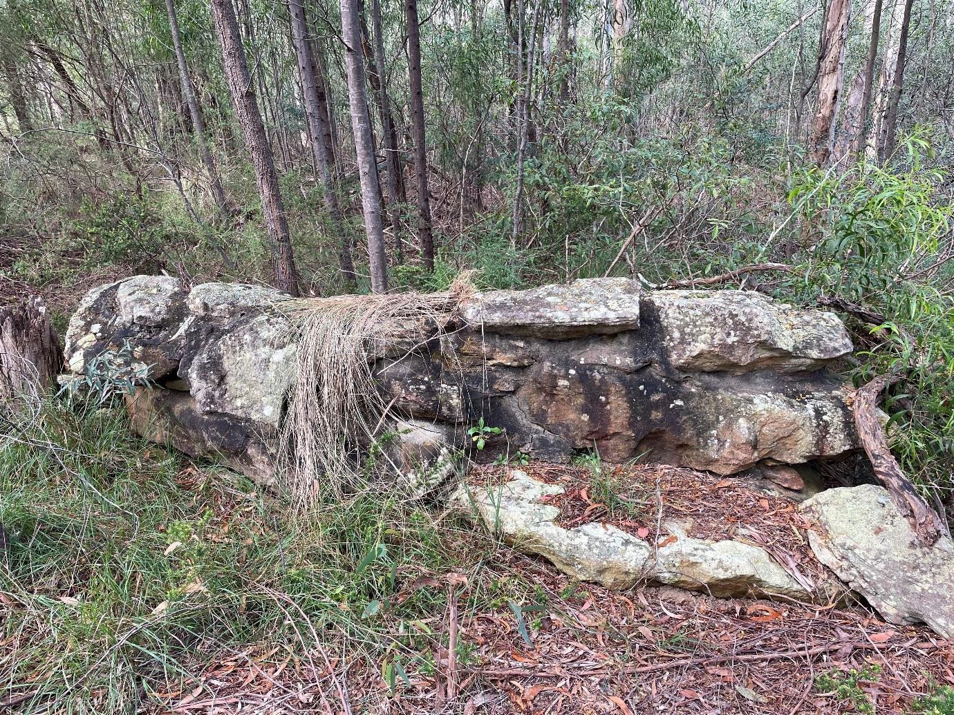
The Hawkesbury landscape is characterised by rugged, rolling to very steep hills on Hawkesbury Sandstone. Hawkesbury Sandstone consisting of medium to coarse-grained quartz sandstone with minor shale and laminite lenses. Sandstones are either massive or crossbedded sheet facies with vertical or subvertical joint sets. The combination of bedding planes and widely spaced joints gives sandstone outcrops a distinctive blocky appearance (DPIE 2020).

There are no mapped watercourses within the Subject Land, with the nearest mapped watercourse occurring 150m south (1st order). Cattai Creek occurs approximately 200m to the west of the Subject Land A small dam on the southern boundary of the Subject Land was dewatered in early 2022
The objectives of this ECA were to assess all possibly occurring ecological values and constraints associated with future development within the Subject Land pursuant to 5 of the Environmental Planning & Assessment Act 1979 (EP&A Act), the BC Act, the EPBC Act and the local planning provisions of The Hills Shire Council, including to:
▪ Undertake background research to determine the likelihood for NSW and/or Commonwealth threatened biota to utilise or occur within the Subject Land during any point of their lifecycles;
▪ Establish the likelihood of occurrence of migratory species, threatened species, endangered populations and threatened ecological communities as listed under the BC Act and/or the EPBC Act;
▪ Identify and map the distribution of vegetation communities within the Subject Land and discuss patch size and condition;
▪ Record presence and the extent of any Priority Weed infestations that require management by law;
▪ Determine potential ecological impacts or risks that may result due to the proposed works;
▪ Recommendation of any controls or additional actions to be taken to protect or improve environmental outcomes of the proposed works; and
▪ Recommend any controls or additional actions to be taken to protect or improve ecological/biodiversity values of the Subject Land
The legislation and policy that are addressed in this report are listed in Table 1
Table 1. Relevant legislation and policy addressed
Legislation/ Policy
Environmental Planning and Assessment Act
1979 (EP&A Act)
Biodiversity Conservation Act (BC Act) (New South Wales)
Relevant Ecological Feature on Site Triggered Action Required
All threatened species, populations and ecological communities and their habitat that occur or are likely to occur within the Subject Land during a part of their lifecycle.
One (1) BC Act listed threatened community was observed within the Subject Land during the site assessment:
▪ Sydney Turpentine Ironbark Forest
One (1) other BC Act listed threatened community could potentially occur within and adjacent to the Subject Land:
▪ Shale Sandstone Transition Forest.
Two threatened BC Act listed flora species were identified within and surrounding the Subject Land:
▪ Epacris purpurascens var. purpurascens; and
▪ Acacia pubescens (Downy Wattle).
No BC Act listed threatened fauna were observed during the site assessment however, several records on or near to the Subject Land have previously been recorded, including:
▪ Myotis macropus (Southern Myotis);
▪ Pteropus poliocephalus (Greyheaded Flying Fox);
▪ Miniopterus orianae oceanensis (Large Bent-winged Bat);
▪ Miniopterus australis (Little Bent-winged Bat);
▪ Scoteanax rueppellii (Greater Broad-nosed Bat);
▪ Falsistrellus tasmaniensis (Eastern False Pipistrelle);
Yes This ecological assessment and all subsequent recommendations relevant to the planning process under 5
Yes Any future Review of Environmental Factors (REF) will need to be accompanied by a Flora and Fauna Assessment (FFA) including a Test of Significance on BC Act listed threatened species.
Legislation/ Policy
▪ Glossopsitta pusilla (Little Lorikeet);
▪ Ninox strenua (Powerful Owl);
▪ Pommerhelix duralensis (Dural Land Snail); and
▪ Calyptorhynchus lathami (Glossy Black-cockatoo)
Environment Protection and Biodiversity Conservation Act 1999 (EPBC Act) (Commonwealth)
One (1) EPBC Act listed threatened ecological community was observed within the Subject Land during the site assessment:
▪ Turpentine-Ironbark Forest of the Sydney Basin Bioregion
One other EPBC Act listed threatened community could potentially occur within and adjacent to the Subject Land:
▪ Shale Sandstone Transition Forest of the Sydney Basin Bioregion.
One EPBC Act listed threatened flora species was identified within the Subject Land during the site assessment:
▪ Acacia pubescens (Downy Wattle)
No EPBC Act listed fauna species were identified within the site during the site assessment however, suitable habitat for threatened fauna was identified.
Yes An assessment of significance of impact from the proposed works on Matters of National Environmental Significance (MNES) EPBC Act Assessment of Significant Impact Criteria may be required if EPBC protected species are found to utilise the Subject Land
Biosecurity Act 2015 (Bio Act)
State Environmental Planning Policy (Biodiversity and Conservation) 2021 –Chapter 2 Vegetation in Non-rural Areas
Three (3) Priority Weeds for the Greater Sydney region were identified within the Subject Land:
▪ Asparagus asparagoides (Bridal creeper);
▪ Lantana camara (Lantana); and
▪ Senecio madagascariensis (Fireweed)
The Subject Land occurs within The Hills LGA and on land zoned as RE1 Public Recreation, therefore the SEPP applies (see section 1.9).
Yes Priority weeds must be managed in accordance with the Biosecurity Act.
Yes Determination of whether a proposed activity meets the aims of the SEPP.
Legislation/ Policy
State Environmental Planning Policy (Biodiversity and Conservation) 2021 –Chapter 4 Koala Habitat Protection 2021
State Environmental Planning Policy (Biodiversity and Conservation) 2021 –Chapter 6 Bushland in Urban Areas
State Environmental Planning Policy (Resilience and Hazards) 2021 –Chapter 2 Coastal Management
Fisheries Management Act 1994 (FM Act)
Water Management Act 2000
Relevant Ecological Feature on Site Triggered Action Required
The Subject Land is not located in an LGA listed in Schedule 2 of the State Environmental Planning Policy (Koala Habitat Protection) 2021 this chapter applies. No None
The Subject Land is not situated within an area specified in Schedule 5 of the SEPP.
No None.
The Subject Land does not contain areas mapped as ‘Coastal Wetlands’ and ‘Proximity to Coastal Wetlands ‘, therefore, Chapter 2 of this SEPP does not apply. No None.
No areas within the Subject Land are listed as Key Fish Habitat under the FM Act.
No None.
No mapped watercourses, or riparian buffers, were identified within the Subject Land. Therefore, the Water Management Act does not apply. No None.
The requirements of the BC Act 2016 and Biodiversity Conservation Regulation 2017 are mandatory for all developments assessed pursuant to Part 5 of the Environmental Planning and Assessment Act 1979 (EP&A Act) submitted in The Hills LGA
For Part 5 activities, the BOS trigger is a significant impact to threatened species or ecological communities. Significant impacts are determined by undertaking a Test of Significance.
The Subject Land contains land zoned as ‘RE1 – Public Recreation’ . The Hills LEP requires that the development satisfies the zone objectives of each zone which are as follows:
▪ RE1: Public Recreation:
o To enable land to be used for public open space or recreational purposes;
o To provide a range of recreational settings and activities and compatible land uses; and
o To protect and enhance the natural environment for recreational purposes.
State Environmental Planning Policy (Biodiversity and Conservation) 2021 – Chapter 2 Vegetation in Non-rural Areas
The aims of this SEPP are:
▪ To protect the biodiversity values of trees and other vegetation in non-rural areas of the state; and
▪ To preserve the amenity of non-rural areas of the state through the preservation of trees and other vegetation.

A thorough literature review of local information relevant to The Hills Council area was undertaken. Searches using NSW Wildlife Atlas (BioNet; DPE 2022b) and the Commonwealth Protected Matters Search Tool (DAWE 2022) were conducted to identify all current threatened flora and fauna, as well as migratory fauna records within a 10km x 10km cell search area centred on the Subject Land These data were used to assist in establishing the presence or likelihood of any ecological values as occurring on or adjacent to the Subject Land and helped inform our Ecologists on what to look for during the site assessment.
Soil landscape and geological mapping was examined to gain an understanding of the environment on the Subject Land and to assist in determining whether any threatened flora or ecological communities may occur there.
A site assessment was undertaken by Narla Environmental on the 1st of September 2022 During the site assessment, the following activities were undertaken:
▪ Identifying and recording the vegetation communities present on the Subject Land, with a focus on identifying any Threatened Ecological Communities (TEC);
▪ Recording a detailed list of flora species encountered on the Subject Land, with a focus on threatened species, species diagnostic of TECs and Priority Weeds;
▪ Recording opportunistic sightings of any fauna species seen or heard on or within the immediate surrounds of the Subject Land;
▪ Identifying and recording the locations of notable fauna habitat such as important nesting, roosting or foraging microhabitats;
▪ Assessing the connectivity and quality of the vegetation within the Subject Land and surrounding area;
▪ Any other habitat features that may support fauna (particularly threatened) species; and
▪ Targeting the habitat of any threatened and regionally significant fauna including:
o Tree hollows (habitat for threatened large forest owls, parrots, cockatoos and arboreal mammals);
o Caves and crevices (habitat for threatened reptiles, small mammals and microbats);
o Termite mounds (habitat for threatened reptiles);
o Soaks (habitat for threatened frogs);
o Wetlands (habitat for threatened fish, frogs and water birds);
o Drainage lines (habitat for threatened fish and frogs);
o Fruiting trees (food for threatened frugivorous birds and mammals);
o Flowering trees (food for threatened nectivorous mammals and birds);
o Trees and shrubs supporting nest structures (habitat for threatened birds and arboreal mammals);
o Logs, bark and artificial debris (habitat for threatened frogs, reptiles and snails
Weather conditions recorded at the nearest weather station (Parramatta) prior to and during the general flora and fauna survey are provided in Table 2 (BOM 2022). The data reveal cool temperatures and low rainfall leading up to the survey These weather conditions were conducive to the emergence and flowering of threatened species that could potentially occur within the Subject Land
Table 2. Weather conditions recorded at Parramatta NSW (station 066124) preceding and during the site assessments (site assessment dates in bold)
Narla examined local satellite imagery, geological mapping, soil landscape mapping and topographic mapping, in addition to existing vegetation mapping in order to stratify the Subject Land and guide the site assessment survey efforts. The following documents were consulted during assessment to assist with the identification of vegetation communities present within the Subject Land:
▪ eSPADE v2.2 (DPE 2022d);
▪ DPE (2010) Southeast NSW Native Vegetation Classification and Mapping - SCIVI. VIS_ID 2230; and
▪ Soil Landscapes of Central and Eastern NSW 1:100,000 Sheet map and report (DPIE 2020).

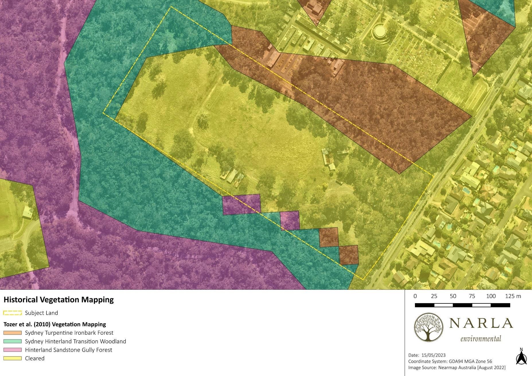
Vegetation mapping conducted by Tozer et al. (2010) indicated the presence of three (3) native vegetation communities within the Subject Land (Figure 2):
▪ Sydney Turpentine Ironbark Forest;
▪ Sydney Hinterland Transition Woodland; and
▪ Hinterland Sandstone Gully Forest
Tozer et al. (2010) also mapped extensive areas within the Subject Land as being cleared.
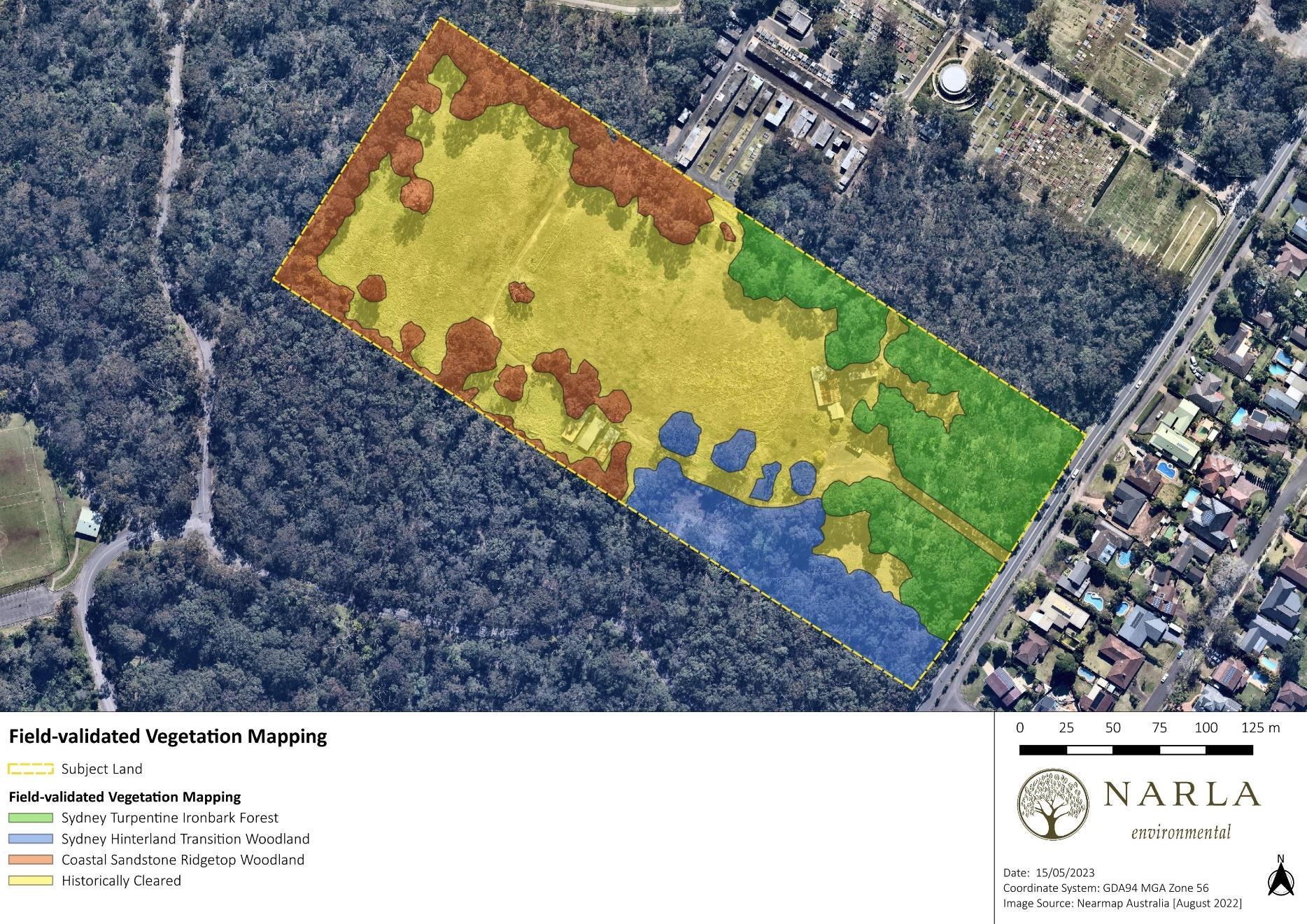
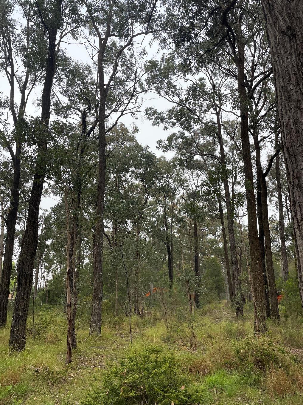
The site assessment revealed four (4) vegetation communities within the Subject Land:
▪ Sydney Turpentine Ironbark Forest;
▪ Sydney Hinterland Transition Woodland;
▪ Coastal Sandstone Ridgetop Woodland; and
▪ Historically Cleared.
The vegetation communities found within the Subject Land are detailed in Table 3, Table 4 , Table 5, and Table 6, and displayed in Figure 3
Sydney Turpentine Ironbark Forest
Extent within Subject Land (approximate) 1.37ha
Description of the Vegetation within the Subject Land
This vegetation community was restricted to the northern and eastern extent of the Subject Land and contained areas of moderate and low condition vegetation. It was characterised by a canopy dominated by Eucalyptus fibrosa. Other less common canopy species included Eucalyptus eugenioides, Eucalyptus punctata, Angophora costata, Eucalyptus resinifera and Syncarpia glomulifera The moderate condition areas contained a diversity of native shrubs and ground covers including Ozothamnus diosmifolius, Leucopogon juniperinus, Breynia oblongifolia, Polyscias sambucifolia, Exocarpus cupressiformis, Acacia parramattensis, Acacia decurrens, Pultenaea villosa, Aristida vagans, Entolasia stricta, Hardenbergia violaceae, Gylcine tabacina, Dichondra repens, Pratia purpurescens, Cheilanthes sieberi and Microlaena stipoides. The lower quality areas had been underscrubbed and contained more weeds including Eragrostis curvula, Cirsium vulgare, Bidens pilosa, Conyza bonariensis, Hypochaeris radicata and Modiola caroliniana
Description from Tozer et al. (2010)
Sydney Turpentine Ironbark Forest is a diverse eucalypt forest with an open shrub layer and grassy groundcover. Having been extensively cleared this unit now occurs predominantly as scattered remnants on shale derived soils on the rim of the Cumberland plain and in the lower Blue Mountains. Local concentrations remain near Thirlmere, Oakdale, Kurrajong, Dural and Pennant Hills. Within this distribution Sydney Turpentine Ironbark Forest occupies undulating terrain and broad ridgetops on shale up to 500m ASL with a mean annual rainfall between 850 and 1250mm. Sydney Turpentine Ironbark Forest shares a number of species with adjoining stands of Blue Gum High Forest (WSF p153) with higher rainfall. Sydney Turpentine Ironbark Forest includes Turpentine Ironbark Forest and Turpentine Ironbark Margin Forest (Map Units 15 and 43) of Tozer 2003. Less than one-quarter of its original distribution remains, and the remaining fragments are threatened by continuing urban expansion, recreational overuse and weed invasion.
Justification of Vegetation Community
BC Act Status
EPBC Act Status
The determination of this community was based on the IBRA Bioregion, IBRA Sub-region, landscape attributes including soil landscapes and elevation, and the presence of a number of diagnostic species.
This vegetation community conforms to the Critically Endangered Ecological Community (CEEC) Sydney Turpentine-Ironbark Forest in the Sydney Basin Bioregion under the BC Act 2016.
Sydney Turpentine Ironbark Forest is described as an open forest, with dominant canopy trees including Syncarpia glomulifera, Eucalyptus punctata, E. paniculata and E. eugenoides. In areas of high rainfall (over 1050 mm per annum) E. saligna is more dominant. The shrub stratum is usually sparse and may contain mesic species such as Sweet Pittosporum Pittosporum undulatum and Elderberry Panax Polyscias sambucifolia. Contains many more species and other references should be consulted to identify these (OEH 2022).
This vegetation community conforms to the Critically Endangered Ecological Community (EEC) Turpentine–Ironbark Forest in the Sydney Basin Bioregion The vegetation within the Subject Land meets the characteristics and conditions thresholds described in the Department of Environment’s listing advice (DoE 2022).
NSW Threatened Species Scientific Committee (2019). Sydney Turpentine Ironbark Forest: Notice of and reasons for Final Determination
References
Department of Planning and Environment (DPE) (2022c) BioNet Vegetation Classification. https://www.environment.nsw.gov.au/research/Visclassification.htm
Tozer et al. (2010) Southeast NSW Native Vegetation Classification and Mapping - SCIVI. VIS_ID 2230
Table 4. Description of Sydney Hinterland Transition Woodland. Sydney Hinterland Transition Woodland
Extent within Subject Land (approximate) 0.81ha
Description of the Vegetation within the Subject Land
This vegetation community was restricted to the southern extent of the Subject Land and contained areas of moderate and low condition. It was characterised by a canopy dominated by Angophora costata and Eucalyptus globoidea. Other less common canopy species included Eucalyptus resinifera, Corymbia gummifera and Syncarpia glomulifera The small tree stratum consisted of a few Allocasuarina littoralis, Jacksonia scoparia and Exocarpus cupressiformis The moderate condition areas contained a diversity of native shrubs and ground covers that highlighted the shale-sandstone transition including Ozothamnus diosmifolius, Leucopogon spp., Hibbertia aspera, Pimelea linifolia, Acacia pubescens, Dodonaea triquetra, Gylcine clandestina, Austrostipa pubescens and Themeda triandra. The lower quality areas bordered the Historically Cleared zone and consisted of the same native upper stratum over a higher density of common weed species.
Description from the NSW Scientific Committee (2010)
Sydney Hinterland Transition Woodland (DSF p146) is a eucalypt woodland with an open understorey of sclerophyll shrubs, sedges, forbs and grasses. This transition woodland encircles the Cumberland Plain rainshadow, on loamy soils typically derived from sediments belonging to the Hawkesbury or Mittagong formations. About one-third of Sydney Hinterland Transition Woodland's original distribution has been cleared and clearing continues in localised areas of suburban expansion including Dural-Maroota, the lower Blue Mountains and east of Campbelltown. However, considerable areas are represented within conservation reserves.
Justification of Vegetation Community
BC Act Status
The determination of this community was based on the IBRA Bioregion, IBRA Sub-region, landscape attributes including soil landscapes and elevation, and the presence of a number of diagnostic species.
Not Listed. Following updates to the NSW Plant Community Type classifications there is the potential that this community could be classified as Shale-Sandstone Transition Forest, which is a Critically Endangered Ecological Community.
EPBC Act Status Not Listed.
Department of Planning and Environment (DPE) (2022c) BioNet Vegetation Classification. https://www.environment.nsw.gov.au/research/Visclassification.htm
References
Tozer et al. (2010) Southeast NSW Native Vegetation Classification and Mapping - SCIVI. VIS_ID 2230
Table 5. Description of Coastal Sandstone Ridgetop Woodland. Coastal Sandstone Ridgetop Woodland
Extent within Subject Land (approximate) 1.37ha
Description of the Vegetation within the Subject Land
This vegetation community was restricted to the peripheries of the western extent of the Subject Land. It was of moderate condition and was characterised by a canopy dominated by Eucalyptus sclerophylla, Corymbia gummifera and Angophora costata with scattered Angophora bakeri The small tree stratum was dominated by Acacia parramattensis with the shrub and ground layers consisting of a diversity of common native sandstone species as well as some weed infestations. Native species included Kunzea ambigua, Bossiaea abcordata, Hakea sericea, Banksia spinulosa, Banksia ericifolia, Leucopogon spp., Pimelea linifolia, Dodonaea triquetra, Persoonia linearis, Lomandra spp., Cheilanthes sieberi, Juncus spp. and Microlaena stipoides A few patches of Lantana camara were scattered throughout this community
Description from Tozer et al. (2010)
Coastal Sandstone Ridgetop Woodland (DSF p131) is a low eucalypt forest with a diverse sclerophyll shrub layer and open groundcover of sedges. It is extensively distributed on the Triassic Hawkesbury sandstone plateaux surrounding the Sydney Basin and is widespread on ridgetops and upper valley slopes of the Hornsby and Woronora Plateaux and the lower Blue Mountains. Coastal Sandstone Ridgetop Woodland occurs up to 600m ASL in areas receiving an average annual rainfall ranging from 850 – 1650mm. Coastal Sandstone Ridgetop Woodland grades into heath (e.g. Coastal Sandstone Plateau Heath HL p117) where soils become shallower, or upland swamps in areas of impeded drainage (e.g. Coastal Upland Swamp FrW p129). Coastal Sandstone Ridgetop Woodland is replaced by Coastal Sandstone Gully Forest (DSF p140) or its drier western counterpart Hinterland Sandstone Gully Forest (DSF p142) in
the deeply incised drainage lines dissecting the plateaux. In the upper Blue Mountains it is replaced by Blue Mountains Ridgetop Woodland on the more elevated Narrabeen Sandstone. Coastal Sandstone Ridgetop Woodland is one of the most intensively sampled units in the study area and is variable and diverse in composition across its range. About one-quarter of its area has been cleared for urban development, but large areas are represented in conservation reserves. High frequency fires, weeds and fragmentation associated with urban encroachment are likely to pose localised threats.
Justification of Vegetation Community
The determination of this community was based on the IBRA Bioregion, IBRA Sub-region, landscape attributes including soil landscapes and elevation, and the presence of a number of diagnostic species.
BC Act Status Not Listed.
EPBC Act Status Not Listed.
Department of Planning and Environment (DPE) (2022c) BioNet Vegetation Classification. https://www.environment.nsw.gov.au/research/Visclassification.htm
References
Tozer et al. (2010) Southeast NSW Native Vegetation Classification and Mapping - SCIVI. VIS_ID 2230
Table 6. Description of Historically Cleared Historically Cleared
Extent within Subject Land (approximate) 3.52ha
Description of the Vegetation within the Subject Land
This vegetation community consisted of open, exotic, grassland areas with little to no shrubs or canopy. Exotic grasses and herbaceous species made up the majority of the vegetation including Eragrostis curvula, Senecio madagascariensis, Andropogon virginicus, Modiola caroliniana, Verbena bonariensis, Bidens pilosa, Plantago lanceolata, Juncus spp., Vicia sativa and Sporobolus spp.
Justification of Vegetation Community
The vegetation within this area consisted of cleared grassland with little to no shrub layer or canopy. As the vegetation could not be assigned to a locally occurring vegetation community it has been classified as historically cleared exotic grassland. This area also included existing roads and tracks.
BC Act Status Not Listed.
EPBC Act Status Not Listed.

Desktop analysis revealed a range of threatened flora as occurring or having the potential to occur on or within a 100km² search area centred on the Subject Land. An incidental threatened species survey was conducted within the Subject Land for all species which had any likelihood of occurring on site (Table 7) Two threatened flora species have historically been recorded from within and surrounding the Subject Land:
▪ Acacia pubescens (Downy Wattle) – Vulnerable under BC and EPBC Act; and
▪ Epacris purpurascens var. purpurascens – Vulnerable under the BC Act.
Both of these species were also recorded during Narla’s site assessment (Figure 4) The Acacia pubescens had all been marked with flagging tape A large number of Epacris purpurascens var. purpurascens specimens were found and none were marked at the time of the site assessment. All other flora species identified by the Narla Ecologists during the site assessment are provided in Appendix A
Table 7. Likelihood of occurrence of threatened flora species within the Subject Land
Species
Number of historical records within approximately 5km of the Subject Land
Acacia bynoeana (Bynoe’s Wattle) Endangered Vulnerable 5
Acacia pubescens (Downy Wattle) Vulnerable Vulnerable 16
Callistemon linearifolius (Netted Bottle Brush) Vulnerable - 2
Occurs in heath or dry sclerophyll forest on sandy soils. Seems to prefer open, sometimes slightly disturbed sites such as trail margins, edges of roadside spoil mounds and in recently burnt patches.
Low-moderate. Potential habitat occurred along the margins and western extent of the Subject Land. This species was not detected during the site assessment in September 2022.
Present. A known population occurs along Gilbert Road.
Grows in dry sclerophyll forest on the coast and adjacent ranges.
Darwinia biflora Vulnerable Vulnerable 373
Dillwynia tenuifolia Vulnerable - 1
Occurs on the edges of weathered shalecapped ridges, where these intergrade with Hawkesbury Sandstone.
In western Sydney, may be locally abundant particularly within scrubby/dry heath areas within Castlereagh Ironbark Forest and Shale Gravel Transition Forest on tertiary alluvium or laterised clays. May also be common in transitional areas where these communities adjoin Castlereagh Scribbly Gum Woodland. At Yengo, is reported to occur in disturbed escarpment woodland on Narrabeen sandstone.
Low. Potential habitat occurred along the margins of the Subject Land. This species was not detected during the site assessment in September 2022.
Low. Potential habitat occurred along the margins of the Subject Land. This species was not detected during the site assessment in September 2022.
Low. Habitat of low suitability occurred along the margins of the Subject Land. This species was not detected during the site assessment in September 2022.
Species BC Act EPBC Act
Number of historical records within approximately 5km of the Subject Land
Epacris purpurascens var. purpurascens Vulnerable - 226 Present. A known population occurs on the southern edge of the Subject Land.
Eucalyptus nicholii (Narrow-leaved Black Peppermint) Vulnerable Vulnerable 5
Eucalyptus scoparia (Wallangarra White Gum) Endangered Vulnerable 1
Eucalyptus sp. Cattai Critically Endangered Critically Endangered 321
Not known to occur naturally in the wild in NSW. Nil.
Not known to occur naturally in the wild in NSW. Nil.
Occurs as a rare emergent tree in scrub, heath and low woodland on sandy soils, usually as isolated individuals or occasionally in small clustered groups. The sites at which it occurs are generally flat and on ridge tops.
Low. Potential habitat occurred along the margins of the Subject Land. This species was not detected during the site assessment in September 2022.
Hibbertia superans Endangered - 580
The species occurs on sandstone ridgetops often near the shale/sandstone boundary.
Leucopogon fletcheri subsp. fletcheri Endangered - 11
Macadamia integrifolia (Macadamia Nut) - Vulnerable 9
Occurs in dry eucalypt woodland or in shrubland on clayey lateritic soils, generally on flat to gently sloping terrain along ridges and spurs.
Low-moderate. Potential habitat occurred along the margins and western extent of the Subject Land. This species was not detected during the site assessment in September 2022.
Low-moderate. Potential habitat occurred along the margins and western extent of the Subject Land. This species was not detected during the site assessment in September 2022.
Not known to occur naturally in the wild in NSW. Nil.
Species BC Act EPBC Act
Number of historical records within approximately 5km of the Subject Land
Persoonia hirsuta (Hairy Geebung) Endangered Endangered 20
Persoonia mollis subsp. maxima Endangered Endangered 1
The Hairy Geebung is found in clayey and sandy soils in dry sclerophyll open forest, woodland and heath, primarily on the Mittagong Formation and on the upper Hawkesbury Sandstone.
Occurs in sheltered aspects of deep gullies or on the steep upper hillsides of narrow gullies on Hawkesbury Sandstone. These habitats support relatively moist, tall forest vegetation communities, often with warm temperate rainforest influences.
Low-moderate. Potential habitat occurred along the margins and western extent of the Subject Land. This species was not detected during the site assessment in September 2022.
Low. Habitat of low suitability occurred along the margins of the Subject Land. This species was not detected during the site assessment in September 2022.
Pimelea curviflora var. curviflora Vulnerable Vulnerable 36
Syzygium paniculatum Endangered Vulnerable 15
Occurs on shaley/lateritic soils over sandstone and shale/sandstone transition soils on ridgetops and upper slopes amongst woodlands. Also recorded in Illawarra Lowalnd Grassy Woodland habitat at Albion Park on the Illawaraa coastal plain.
On the central coast Magenta Lilly Pilly occurs on gravels, sands, silts and clays in riverside gallery rainforests and remnant littoral rainforest communities.
Low-moderate. Potential habitat occurred along the margins and western extent of the Subject Land. This species was not detected during the site assessment in September 2022.
Low. Habitat of low suitability occurred along the margins of the Subject Land. This species was not detected during the site assessment in September 2022.
Species
Number of historical records within approximately 5km of the Subject Land
Tetratheca glandulosa Vulnerable - 13
It is usually found in low open forest/woodland with a mixed shrub understorey and grassy groundcover. However, it has also been recorded in heathland and moist forest. The majority of populations occur on low nutrient soils associated with the Awaba Soil Landscape. It generally prefers well-drained sites below 200m elevation and annual rainfall between 1000 - 1200mm. The preferred substrates are sandy skeletal soil on sandstone, sandy-loam soils, low nutrients; and clayey soil from conglomerates, pH neutral.
Low-moderate. Potential habitat occurred along the margins and western extent of the Subject Land. This species was not detected during the site assessment in September 2022.
Details of the fauna habitat recorded in the Subject Land are included in Table 8
Table 8. Fauna habitat values identified within the Subject Land Habitat component Site values
Coarse woody debris Present
Rock outcrops and bush rock Present.
Caves, crevices and overhangs
Culverts, bridges, mine shafts, or abandoned structures
Nectar/lerp-bearing Trees
Small crevices were present
Absent.
Nectar-bearing Eucalypts were recorded within the Subject Land These trees may provide intermittent nectar and/or lerp sources for nomadic nectivores such as Grey-headed Flying-fox
Nectar-bearing shrubs
Acacia spp. and Kunzea spp. occurred within the vegetated areas of the Subject Land These shrubs may provide intermittent nectar and/or lerp sources for similar nectivores.
Large stick nests Absent
Sap and gum sources
Native sap and gum source trees were recorded within the vegetated areas of the Subject Land
She-oak fruit (Glossy Black Cockatoo feed) Present.
Seed-bearing trees and shrubs
Soft-fruit-bearing trees
Dense shrubbery and leaf litter
Tree hollows
Decorticating bark
Wetlands, soaks and streams
Seed-bearing trees such as the Eucalypt species identified within the Subject Land may provide foraging habitat for Gang-gang Cockatoo.
Trees such as Pittosporum undulatum occur in parts of the Subject Land which may provide foraging habitat for fructivores
Present. Leaf litter and dense shrubbery were present within the vegetated areas of the Subject Land
Present. A range of hollow sizes from small (5cm diameter) to very large (>25cm diameter)
Decorticating bark was present within the Subject Land which may provide habitat for threatened microbat species.
Absent.
Open water bodies Absent.
Estuarine, beach, mudflats, and rocky foreshores Absent.
No threatened fauna were observed during the survey within or surrounding the Subject Land however, desktop analysis revealed a range of threatened fauna as occurring or having the potential to occur on or within a 100km² search area centred on the Subject Land. Likelihood of occurrence has been assessed for potentially occurring threatened fauna (Table 9).

The following EPBC Act listed migratory terrestrial fauna species have been identified with the possibility of occurring within the Subject Land:
▪ Myiagra cyanoleuca (Satin Flycatcher);
▪ Rhipidura rufifrons (Rufous Fantail);
▪ Monarcha melanopsis (Black-faced Monarch);
▪ Symposiachrus trivirgatus (Spectacled Monarch);
▪ Cuculus optatus (Oriental Cuckoo);
▪ Hirundapus caudacutus (White-throated Needletail); and
▪ Motacilla flava (Yellow Wagtail).
Whilst none of these species were confirmed within the Subject Land, potential foraging habitat was present.
Table 9 Likelihood of occurrence of threatened fauna species within the Subject Land.
Anthochaera phrygia (Regent Honeyeater)
Artamus cyanopterus cyanopterus (Dusky Woodswallow) V - Low
The species inhabits dry open forest and woodland, particularly Box-Ironbark woodland, and riparian forests of River Sheoak. The Regent Honeyeater is a generalist forager, although it feeds mainly on the nectar from a relatively small number of eucalypts that produce high volumes of nectar. Potential foraging habitat is present within the Subject Land.
This species often inhabits dry, open eucalypt forests and woodlands with an open or sparse understorey of eucalypt saplings, acacias and other shrubs, and groundcover of grasses or sedges and fallen woody debris. Potential foraging habitat is present within the Subject Land.
There are three known key breeding areas, two of them in NSW - Capertee Valley and Bundarra-Barraba regions. The Subject Land is not within these regions.
This species nests in dry open Eucalypt Forest. No nests were identified within the Subject Land.
Botaurus poiciloptilus (Australasian Bittern) E E
Calidris ferruginea (Curlew Sandpiper) E CE
Favours permanent freshwater wetlands with tall, dense vegetation, particularly bullrushes (Typha spp.) and spikerushes (Eleocharis spp.). No such habitat occurred within the Subject Land.
It generally occupies littoral and estuarine habitats, and in New South Wales is mainly found in intertidal mudflats of sheltered coasts. No such habitat occurred within the Subject Land.
Breeding occurs in summer from October to January; nests are built in secluded places in densely vegetated wetlands on a platform of reeds. No such habitat occurred within the Subject Land.
This species does not bread in Australia.
Callocephalon fimbriatum (Gang-gang Cockatoo)
Likelihood of Occurrence
E Low
Calyptorhynchus lathami (Glossy Black Cockatoo)
- Low
Habitat Present Within the Subject Land
In spring and summer, generally found in tall mountain forests and woodlands, particularly in heavily timbered and mature wet sclerophyll forests. In autumn and winter, the species often moves to lower altitudes in drier more open eucalypt forests and woodlands, particularly boxgum and box-ironbark assemblages, or in dry forest in coastal areas and often found in urban areas. Potential habitat occurred within the Subject Land.
Inhabits open forest and woodlands of the coast and the Great Dividing Range where stands of sheoak occur. Black Sheoak (Allocasuarina littoralis) and Forest Sheoak (A. torulosa) are important foods. The Subject Land contains foraging habitat for this species.
Habitat Present Within the Subject Land
Favours old growth forest and woodland attributes for nesting and roosting. Nests are located in hollows that are 10 cm in diameter or larger in eucalypts. Breeding habitat occurred within the Subject Land.
Chalinolobus dwyeri (Large-eared Pied Bat)
V Low
Found in well-timbered areas containing gullies. No such habitat occurred within the Subject Land.
Dependent on large hollow-bearing eucalypts for nest Lands. Breeding habitat occurred within the Subject Land.
Roosts in caves (near their entrances), crevices in cliffs, old mine workings and in the disused, bottle-shaped mud nests of the Fairy Martin (Petrochelidon ariel), frequenting low to mid-elevation dry open forest and woodland close to these features. Females have been recorded raising young in maternity roosts (c. 20-40 females) from November through to January in roof domes in sandstone caves and overhangs. They remain loyal to the same cave over many years. No such habitat occurred within the Subject Land.
Species
Charadrius leschenaultia (Greater Sand Plover)
Chthonicola sagittata (Speckled Warbler)
Climacteris picumnus
victoriae (Brown Treecreeper (eastern subspecies))
Likelihood of Occurrence
V Very Low
Foraging Habitat Present Within the Subject Land
Almost entirely restricted to coastal areas in NSW, occurring mainly on sheltered sandy, shelly or muddy beaches or estuaries with large intertidal mudflats or sandbanks. No such habitat occurred within the Subject Land.
Breeding Habitat Present Within the Subject Land
Roosts during high tide on sandy beaches and rocky shores; begin foraging activity on wet ground at low tide, usually away from the edge of the water; individuals may forage and roost with other waders. No such habitat occurred within the Subject Land.
- Low
- Very Low
Typical habitat would include scattered native tussock grasses, a sparse shrub layer, some eucalypt regrowth and an open canopy. No such habitat occurred within the Subject Land.
Found in eucalypt woodlands (including Box-Gum Woodland) and dry open forest of the inland slopes and plains inland of the Great Dividing Range; mainly inhabits woodlands dominated by stringybarks or other rough-barked eucalypts, usually with an open grassy understorey, sometimes with one or more shrub species; also found in mallee and River Red Gum (Eucalyptus camaldulensis) Forest bordering wetlands with an open understorey of acacias, saltbush, lignum, cumbungi and grasses; usually not found in woodlands with a dense shrub layer; fallen timber is an important habitat component for foraging; also recorded, though less commonly, in similar woodland habitats on the coastal ranges and plains. No such habitat occurred within the Subject Land.
The rounded, domed, roughly built nest of dry grass and strips of bark is located in a slight hollow in the ground or the base of a low dense plant, often among fallen branches and other litter. A side entrance allows the bird to walk directly inside. No such habitat occurred within the Subject Land.
Hollows in standing dead or live trees and tree stumps are essential for nesting. Breeding habitat occurred within the Subject Land.
Species
Daphoenositta chrysoptera (Varied Sittella)
Dasyornis brachypterus (Eastern Bristlebird)
Dasyurus maculatus (Spotted-tailed Quoll)
Delma impar (Striped Legless Lizard)
Likelihood of Occurrence
Foraging Habitat Present Within the Subject Land
Inhabits eucalypt forests and woodlands, especially those containing rough-barked species and mature smooth-barked gums with dead branches, mallee and Acacia woodland. Potential habitat occurred within the Subject Land.
Habitat for central and southern populations is characterised by dense, low vegetation including heath and open woodland with a heathy understorey. In northern NSW the habitat occurs in open forest with dense tussocky grass understorey and sparse mid-storey near rainforest ecotone; all of these vegetation types are fire prone. No such habitat occurred within the Subject Land.
A generalist predator with a preference for medium-sized (500g-5kg) mammals. Consumes a variety of prey, including gliders, possums, small wallabies, rats, birds, bandicoots, rabbits, reptiles and insects. Also eats carrion and takes domestic fowl. Potential foraging habitat occurred within the Subject Land.
Breeding Habitat Present Within the Subject Land
Builds a cup-shaped nest of plant fibres and cobwebs in an upright tree fork high in the living tree canopy, and often re-uses the same fork or tree in successive years. Potential habitat occurs within the Subject Land.
Nests are elliptical domes constructed on or near the ground amongst dense vegetation. No such habitat occurred within the Subject Land.
This species uses hollow-bearing trees, fallen logs, small caves, rock outcrops and rockycliff faces as den Lands. Breeding habitat occurred within the Subject Land.
Found mainly in Natural Temperate Grassland but has also been captured in grasslands that have a high exotic component. No such habitat occurred within the Subject Land.
Species
Erythrotriorchis radiatus (Red Goshawk)
Falco hypoleucos (Grey Falcon)
Falsistrellus tasmaniensis (Eastern False Pipistrelle)
Glossopsitta pusilla (Little Lorikeet)
Likelihood of Occurrence
CE V Very Low
Foraging Habitat Present Within the Subject Land
Red Goshawks inhabit open woodland and forest, preferring a mosaic of vegetation types, a large population of birds as a source of food, and permanent water, and are often found in riparian habitats along or near watercourses or wetlands. In NSW, preferred habitats include mixed subtropical rainforest, Melaleuca swamp forest and riparian Eucalyptus forest of coastal rivers. No such habitat occurred within the Subject Land.
Breeding Habitat Present Within the Subject Land
E V Very Low
V - Moderate-High
The birds lay clutches of 1-2 eggs between July and September, in a stick nest in a tall tree (>20 m tall) within 1 km of a watercourse or wetland. No such habitat occurred within the Subject Land.
V - Low
Usually restricted to shrubland, grassland and wooded watercourses of arid and semi-arid regions, although it is occasionally found in open woodlands near the coast. No such habitat occurred within the Subject Land.
This species prefers moist habitats with trees taller than 20m. Feeds on insects. Potential prey items may occur within the Subject Land, however foraging habitat is suboptimal given the Subject Land is heavily degraded.
Forages primarily in the canopy of open Eucalyptus forest and woodland, yet also finds food in Angophora, Melaleuca and other tree species. Riparian habitats are particularly used, due to higher soil fertility and hence greater productivity. Potential foraging habitat occurs within the Subject Land.
Generally, roosts in Eucalypt hollows, but has also been found under loose bark on trees or in buildings nearby foraging habitat. Breeding habitat was present within the Subject Land.
This species favours small hollows in Eucalypts. Breeding habitat was present within the Subject Land.
Species
Likelihood of Occurrence
Grantiella picta (Painted Honeyeater) P V Low
Foraging Habitat Present Within the Subject Land
Inhabits Boree/ Weeping Myall (Acacia pendula), Brigalow (A. harpophylla) and Box-Gum Woodlands and Box-Ironbark Forests. Potential foraging habitat occurs within the Subject Land.
Breeding Habitat Present Within the Subject Land
Nest from spring to autumn in a small, delicate nest hanging within the outer canopy of drooping eucalypts, she-oak, paperbark or mistletoe branches. Potential breeding habitat occurs within the Subject Land.
Heleioporus australiacus (Giant Burrowing Frog) V V Low
Hieraaetus morphnoides (Little Eagle) V - Low
Found in heath, woodland and open dry sclerophyll forest on a variety of soil types except those that are clay based. Potential foraging habitat occurs within the Subject Land.
Occupies open eucalypt forest, woodland or open woodland. Preys on birds, reptiles and mammals, occasionally adding large insects and carrion. Potential prey items may occur within the Subject Land
Breeding habitat of this species is generally soaks or pools within first or second order streams. They are also commonly recorded from 'hanging swamp' seepage lines and where small pools form from the collected water. No such habitat occurred within the Subject Land.
This species nests in tall living trees within a remnant patch, where pairs build a large stick nest in winter. No stick nests were identified within the Subject Land at the time of the Land assessment
Hirundapus caudacutus (White-throated Needletail) P V Low
This species has been recorded eating a wide variety of insects, including beetles, cicadas, flying ants, bees, wasps, flies, termites, moths, locusts and grasshoppers. Prey items may be present within the Subject Land.
N/A. This species does not breed in Australia.
Species
Hoplocephalus bungaroides (Broad-headed Snake)
Isoodon obesulus obesulus
(Southern Brown Bandicoot)
Likelihood of Occurrence
E V Low
E E Low
Foraging Habitat Present Within the Subject Land
Breeding Habitat Present Within the Subject Land
Shelters in rock crevices and under flat sandstone rocks on exposed cliff edges during autumn, winter and spring. No such habitat is present within the Subject Land. Moves from the sandstone rocks to shelters in crevices or hollows in large trees within 500m of escarpments in summer. Potential breeding habitat was present within the Subject Land
They are generally only found in heath or open forest with a heathy understorey on sandy or friable soils. No such habitat is present within the Subject Land.
Ixobrychus flavicollis (Black Bittern)
Lathamus discolor (Swift Parrot)
V - Very Low
Litoria aurea (Green and Golden Bell Frog)
Lophoictinia isura (Square-tailed Kite)
E CE Low
Inhabits both terrestrial and estuarine wetlands, generally in areas of permanent water and dense vegetation. Where permanent water is present, the species may occur in flooded grassland, forest, woodland, rainforest and mangroves. No such habitat is present within the Subject Land.
Potential feed trees occurred on the Subject Land which may attract this species if they are flowering profusely.
During the day, roosts in trees or on the ground amongst dense reeds. No such habitat occurs within the Subject Land.
N/A. The Swift Parrot only breeds in Tasmania.
E V Very Low
V - Low
This species inhabits marshes, dams and stream-sides, particularly those containing bullrushes (Typha spp.) or spikerushes (Eleocharis spp.). No such habitat was present within the Subject Land.
Found in a variety of timbered habitats including dry woodlands and open forests. Shows a particular preference for timbered watercourses. Potential habitat was present within the Subject Land.
Species
Melithreptus gularis gularis (Black-chinned Honeyeater (eastern subspecies))
Likelihood of Occurrence
- Low
Foraging Habitat Present Within the Subject Land
Breeding Habitat Present Within the Subject Land
Occupies mostly upper levels of drier open forests or woodlands dominated by box and ironbark eucalypts, especially Mugga Ironbark (Eucalyptus sideroxylon), White Box (E. albens), Inland Grey Box (E. microcarpa), Yellow Box (E. melliodora), Blakely's Red Gum (E. blakelyi) and Forest Red Gum (E. tereticornis). Habitat of low suitability was present within the Subject Land.
Meridolum corneovirens (Cumberland Plain Land Snail) E - Low
Micronomus norfolkensis
(Eastern Coastal Freetailed Bat)
Miniopterus australis (Little Bent-winged Bat)
Miniopterus orianae oceanensis
(Large Bent-winged Bat)
V - Low
Primarily inhabits Cumberland Plain Woodland (a critically endangered ecological community). This community is a grassy, open woodland with occasional dense patches of shrubs. It is also known from Shale Gravel Transition Forests, Castlereagh Swamp Woodlands and the margins of River-flat Eucalypt Forest, which are also listed communities. No such habitat was present within the Subject Land.
Occur in dry sclerophyll forest, swamp forests and mangrove forests east of the Great Dividing Range, feeding on insects. Potential prey items may occur within the Subject Land
V - Moderate
VHigh (previously recorded within the Subject Land)
This species forage for small insects beneath the canopy of densely vegetated habitats. No such habitat occurs within the Subject Land.
Hunt in forested areas, catching moths and other flying insects above the tree tops. Potential foraging habitat occurs within the Subject Land.
Roost mainly in tree hollows but will also roost under bark or in man-made structures. Hollows were present within the Subject Land.
Only five nursery Lands/maternity colonies are known in Australia. The Subject Land is not located near a known maternity colony; therefore, it is not expected breeding habitat will be impacted.
This species only breeds in caves. No such habitat was identified within, or in close proximity to, the Subject Land
Species
Mixophyes balbus (Stuttering Frog)
Likelihood of Occurrence
V Low
Foraging Habitat Present Within the Subject Land
Breeding Habitat Present Within the Subject Land
Myotis macropus (Southern Myotis)
- Moderate-High
Neophema pulchella (Turquoise Parrot) V - Low
Found in rainforest and wet, tall open forest in the foothills and escarpment on the eastern side of the Great Dividing Range. No such habitat was present within the Subject Land.
This species forages over streams and pools catching insects and small fish by raking their feet across the water surface. No such habitat was present within the Subject Land.
Prefers to feed in the shade of a tree and spends most of the day on the ground searching for the seeds or grasses and herbaceous plants, or browsing on vegetable matter. Potential foraging habitat was identified within the Subject Land
Breed in streams during summer after heavy rain. Breeding habitat was not present within the Subject Land.
Generally, roost in groups of 10 - 15 close to water in caves, mine shafts, hollow-bearing trees, storm water channels, buildings, under bridges and in dense foliage. Breeding habitat was not present within the Subject Land.
Nests in tree hollows, logs or posts. Breeding habitat was present within the Subject Land.
Ninox connivens (Barking Owl) V - Low
Preferentially hunts small arboreal mammals such as Squirrel Gliders and Common Ringtail Possums, but when loss of tree hollows decreases these prey populations the owl becomes more reliant on birds, invertebrates and terrestrial mammals such as rodents and rabbits. Potential prey items may occur within the Subject Land.
Breeding occurs in hollows of large, old trees. Living eucalypts are preferred though dead trees are also used. Breeding habitat was present within the Subject Land.
Species
Ninox strenua (Powerful Owl) V -
Numenius madagascariensis (Eastern Curlew)
Likelihood of Occurrence
High (known to occur in neighbouring vegetation)
P CE Very Low
Foraging Habitat Present Within the Subject Land
Main prey items are medium-sized arboreal marsupials, particularly the Greater Glider, Common Ringtail Possum and Sugar Glider. Potential prey items may occur within the Subject Land
This species generally occupies coastal lakes, inlets, bays and estuarine habitats, and in New South Wales is mainly found in intertidal mudflats and sometimes saltmarsh of sheltered coasts. No such habitat occurs within the Subject Land.
Breeding Habitat Present Within the Subject Land
This species nest in large tree hollows (at least 0.5 m deep), in large eucalypts (diameter at breast height of 80-240 cm) that are at least 150 years old. Potential breeding habitat was present within the Subject Land.
This species does not breed in Australia
Pandion cristatus (Eastern Osprey)
Petauroides volans (Greater Glider)
V - Very Low
Petaurus australis (Yellow-bellied Glider)
P V Very Low
This species favours coastal areas, especially the mouths of large rivers, lagoons and lakes. Feed on fish over clear, open water. No such habitat occurs within the Subject Land.
Nests are made high up in dead trees or in dead crowns of live trees, usually within one kilometre of the sea. No nests were identified within the Subject Land at the time of the Land assessment.
V V Low
This species is typically found in taller, montane, moist eucalypt forests with relatively old trees and abundant hollows. Such habitat does not occur within the Subject Land.
Occur in tall mature eucalypt forest generally in areas with high rainfall and nutrient rich soils. Feed primarily on plant and insect exudates, including nectar, sap, honeydew and manna with pollen and insects providing protein. Such habitat does not occur within the Subject Land.
This species breeds in taller, montane, moist eucalypt forests with relatively old trees and abundant hollows. Such habitat does not occur within the Subject Land.
Den, often in family groups, in hollows of large trees. Breeding habitat does not occur within the Subject Land.
Species
Likelihood of Occurrence
Petroica phoenicea (Flame Robin) V - Low
Petroica rodinogaster (Pink Robin) V - Low
Petrogale penicillata (Brush-tailed Rockwallaby) E V Very Low
Foraging Habitat Present Within the Subject Land
Breeding Habitat Present Within the Subject Land
Phascolarctos cinereus (Koala) V V Very Low
Prefers clearings or areas with open understoreys. Potential habitat occurred within the Subject Land.
Breeds in upland tall moist eucalypt forests and woodlands, often on ridges and slopes. Breeding habitat was present within the Subject Land.
Inhabits rainforest and tall, open eucalypt forest, particularly in densely vegetated gullies. No such habitat was present within the Subject Land.
Occupy rocky escarpments, outcrops and cliffs with a preference for complex structures with fissures, caves and ledges, often facing north. No such habitat was present within the Subject Land.
Inhabit eucalypt woodlands and forests.
Feed on the foliage of more than 70 eucalypt species and 30 non-eucalypt species, but in any one area will select preferred browse species. Potential foraging habitat was identified within the Subject Land.
Potential breeding habitat was identified within the Subject Land, however this is considered suboptimal given the highly fragmented and urbanised nature of the Land.
Polytelis swainsonii (Superb Parrot) V V Low
Inhabit Box-Gum, Box-Cypress-pine and Boree Woodlands and River Red Gum Forest. Habitat of low suitability was present within the Subject Land.
In the Riverina the birds nest in the hollows of large trees (dead or alive) mainly in tall riparian River Red Gum Forest or Woodland. On the South West Slopes nest trees can be in open Box-Gum Woodland or isolated paddock trees. Species known to be used are Blakely’s Red Gum, Yellow Box, Apple Box and Red Box.No such habitat was present within the Subject Land
Species
Pommerhelix duralensis (Dural Land Snail)
Likelihood of Occurrence Foraging Habitat Present Within the Subject Land Breeding Habitat Present Within the Subject Land
E Very Low
Pseudomys novaehollandiae (New Holland Mouse)
V Very Low
The species has a strong affinity for communities in the interface region between shale-derived and sandstonederived soils, with forested habitats that have good native cover and woody debris. Habitat for this species was present within the Subject Land.
Known to inhabit open heathlands, woodlands and forests with a heathland understorey and vegetated sand dunes. No such habitat occurs within the Subject Land.
The species has also been observed resting in exposed areas, such as on exposed rock or leaf litter, however it will also shelter beneath leaves, rocks and light woody debris. The Subject Land contains leaf litter or light woody debris.
Breeding habitat is the same as foraging habitat. No such habitat occurs within the Subject Land.
Pseudophryne australis (Red-crowned Toadlet)
- Low
Pteropus poliocephalus (Grey-headed Flying-fox) V V Low
Occurs in open forests, mostly on Hawkesbury and Narrabeen Sandstones. Shelters under rocks and amongst masses of dense vegetation or thick piles of leaf litter. Potential breeding habitat occurred within the Subject Land.
Occur in subtropical and temperate rainforests, tall sclerophyll forests and woodlands, heaths and swamps as well as urban gardens and cultivated fruit crops. Feed on the nectar and pollen of native trees, in particular Eucalyptus, Melaleuca and Banksia, and fruits of rainforest trees and vines. Potential foraging habitat was identified with the Subject Land
Breeding congregations occur in dense vegetation and debris beside ephemeral creeks and gutters. Red-crowned Toadlets have not been recorded breeding in waters that are even mildly polluted or with a pH outside the range 5.5 to 6.5. No such habitat occurs within the Subject Land.
No breeding camps were identified within or surrounding the Subject Land
Pycnoptilus floccosus (Pilotbird) P V Low
This species requires wet sclerophyll forests in temperate zones in moist gullies with dense undergrowth or dry sclerophyll forests and woodlands occupying dry slopes and ridges No such habitat was present within the Subject Land.
Species
Likelihood of Occurrence
Rostratula australis (Australian Painted Snipe) E E Very Low
Saccolaimus flaviventris (Yellow-bellied Sheathtail-bat) V - Low
Scoteanax rueppellii (Greater Broad-nosed Bat) V - Moderate-High
Foraging Habitat Present Within the Subject Land
Breeding Habitat Present Within the Subject Land
Prefers fringes of swamps, dams and nearby marshy areas where there is a cover of grasses, lignum, low scrub or open timber. No such habitat occurs within the Subject Land. The nest consists of a scrape in the ground, lined with grasses and leaves. No nests were identified within the Subject Land at the time of the Land assessment.
This species feeds on insects, flying high and fast over the forest canopy. Prey items may be present within the Subject Land.
Roosts singly or in groups of up to six, in tree hollows and buildings. Tree hollows occurred within the Subject Land.
Utilises a variety of habitats from woodland through to moist and dry eucalypt forest and rainforest, though it is most commonly found in tall wet forest. Prey items may be present within the Subject Land. Although this species usually roosts in tree hollows, it has also been found in buildings. Tree hollows occurred within the Subject Land.
Tyto novaehollandiae (Masked Owl) V - Very Low
Vespadelus troughtoni (Eastern Cave Bat) V - Low
The Masked Owl inhabits forests, woodlands, timbered waterways and open country on the fringe of these areas. The main requirements are tall trees with suitable hollows for nesting and roosting and adjacent areas for foraging. Suboptimal foraging habitat is present within the Subject Land.
Roosts and breeds in moist eucalypt forested gullies, using large tree hollows or sometimes caves for nesting. Large hollows were identified within the Subject Land.
A cave-roosting species that is usually found in dry open forest and woodland, near cliffs or rocky overhangs; has been recorded roosting in disused mine workings, occasionally in colonies of up to 500 individuals. No caves were found within the Subject Land.

Future works should avoid areas mapped as Sydney turpentine Ironbark Forest This ecological community is at risk of serious and irreversible impacts and therefore impacting any of the vegetation mapped as Sydney Turpentine Ironbark Forest could be considered a significant impact. Similarly, the vegetation in the south-eastern portion of the Subject Land has the potential to be classified as Shale-Sandstone Transition Forest, which is a community also at risk of serious and irreversible impacts. Until such time that certainty around the conservation status of this vegetation community can be confirmed, all efforts should be made to avoid vegetation removal. Impacts to any threatened entity that is at risk of a serious and irreversible impact will likely result in the project triggering the BOS and requiring offsetting.
Future development should avoid impacting the populations of the two threatened flora species identified within the Subject Land. Impacts to these threatened species could potentially be considered significant. It is possible any development that does not directly impact the population of Epacris purpurascens var. purpurascens may still cause indirect impacts. If indirect impacts cannot be minimised and mitigated sufficiently, the BOS may be triggered and offsetting required.
Several eucalypts that occur throughout the Subject Land contain hollows that may be important habitat for threatened species such as owls and insectivorous microbats Surveys should be undertaken to determine whether these trees are used as breeding habitat and if they are, priority given to their retention
The historically cleared areas of the Subject Land, which account for approx. 3.52ha, have the highest development potential. These areas have the lowest ecological value
The use of synthetic turf should be kept to an absolute minimum owing to the detrimental impact it has to the surrounding environment. Synthetic turfs can lead to increases in microplastics as well as contaminated runoff entering areas of surrounding bushland which can then enter into nearby watercourses.
If synthetic turf must be utilised it should only be used on one playing field and should not utilise rubber or plastic/infill but rather comprise of a blend with natural turf. A detailed sediment and erosion control plan will also need to be prepared to minimise the impacts of runoff into adjoining vegetation.
The already cleared section within the south east of the Subject Land can be utilised for any over flow parking that may be required, as long as no further vegetation removal is proposed to increase its size. To create access to this area a route should be selected which doesn’t require the removal of any trees. If trees are required to be removed to create access, it should be kept to an absolute minimum and only low priority trees with no habitat
should be removed. The more vegetation that requires removal from this area the greater the risk will become of a significant impact.
All lighting proposed for any future development should aim to minimise light spill into adjoining vegetated areas as much as possible. The areas surrounding the property are known to provide habitat to several threatened nocturnal species such as Powerful Owls, which could be displaced by increases in light spill.
Narla has mapped the Subject Land into three (3) levels of ‘Biodiversity Values and Development Constraints’ (Figure 5). The interpretation of each zone is detailed in Table 10
This map was produced using information gathered from both desktop assessment of existing/historical mapping and data obtained from fieldwork undertaken by the Narla Ecologists. It is to be used as a guide only and a strong degree of caution must be expressed when interpreting it.
Table 10. Biodiversity values and constraints mapping key
Zone Description
This zone is deemed to have high potential for future development with accompaniment of the appropriate environmental assessments and implementation of appropriate restrictions and guidelines.
Low Constraints Area – Green
Moderate Constraints Area –Orange
This zone encompasses:
▪ Areas of historically cleared grassland that is dominated by weeds; and
▪ Areas void of vegetation such as tracks and roads
This zone is deemed to have a moderate potential for future development with accompaniment of the appropriate environmental assessments, as well as potential impact mitigation strategies (such as vegetation management plans and project ecologist services).
This zone encompasses:
▪ Vegetation communities that are not listed under the BC or EPBC Act
High Constraints Area – Red
This zone is deemed to have a low potential for future development without the accompaniment of substantial environmental assessments, impact mitigation strategies (such as a offsetting, targeted surveys, vegetation management plan, project ecologist services) and adequate habitat replacement (nest boxes, tree planting)
This zone encompasses all areas mapped as a TEC.

The preferred option for the former Pony Club site (Figure 6) has mainly been situated on areas deemed to contain low or moderate biodiversity constraints (Figure 5). The proposed option has attempted to minimise impacts to areas of high constraints as much as possible. However, owing to the vegetated nature of the site and the requirements of the project, impacts could not be completely avoided.
The preferred option has utilised the largely cleared portion of the site for the majority of works, with overflow parking utilising an area amongst vegetation that has also previously been cleared. Impacts to vegetation have been restricted to areas of vegetation on the fringes of a large patch, and has avoided the fragmentation of any identified vegetation communities.
The efforts displayed during the planning stages to firstly avoid impacts to high constraints areas where possible, as well as by proposing to implement mitigation measures such as the habitat replacement and revegetation, to offset potential impacts leads to the conclusion that a significant impact to any threatened species or ecological community is unlikely to occur as a result of the proposed option.
When plans are finalised and appropriate impact assessments are prepared for the project a Test of Significance (5-Part Test) under the BC Act 2016 and if necessary an EPBC Act Assessment of Significant Impact Criteria will need to be prepared to confirm no significant impact.
The Subject Land was found to contain numerous Ecological Constraints, such as:
▪ One (possibly two) BC Act listed CEEC:
o Sydney Turpentine Ironbark Forest; and
o Shale Sandstone Transition Forest (potential)
▪ One (1) EBPC Act listed EEC:
o Sydney Turpentine Ironbark Forest in the Sydney Basin.
▪ Two threatened plant species:
o Acacia pubescens (Downy Wattle); and
o Epacris purpurascens var. purpurascens
▪ ‘Biodiversity Values’ on the Biodiversity Values Map (DPE 2022a); and
▪ Hollow-bearing trees with hollows ranging from small to very large Future works within the Subject Land should avoid the impacting the TEC(s) and should be predominately located within areas mapped as containing ‘Low Biodiversity Value and Development Constraints’.
If works proceed using the preferred option shown in this report and if the mitigation measures suggested are implemented, then it is considered unlikely that a significant impact would occur to any threatened species or ecological community as a result of the proposed works.
Bureau of Meteorology (BOM) (2022) Parramatta, New South Wales, August/September 2022 Daily Weather Observations http://www.bom.gov.au/climate/dwo/202205/html/IDCJDW2097.202205.shtml
Commonwealth of Australia Department of the Environment (2022) Protected Matters Search Tool, http://www.environment.gov.au/epbc/pmst/
Department of the Environment (2022). Turpentine-Ironbark Forest of the Sydney Basin Bioregion in Community and Species Profile and Threats Database, Department of the Environment, Canberra. Available from: http://www.environment.gov.au/sprat. Accessed 2022-09-18T08:45:14AEST.
Department of Planning and Environment (DPE) (2022a) Biodiversity Values Map and Threshold Tool
Department of Planning and Environment (DPE) (2022b) BioNet. The Atlas of NSW Wildlife http://www.bionet.nsw.gov.au/
Department of Planning and Environment (DPE) (2022c) BioNet Vegetation Classification. https://www.environment.nsw.gov.au/research/Visclassification.htm
Department of Planning and Environment (DPE) (2022d) eSPADE v2.2 https://www.environment.nsw.gov.au/eSpade2Webapp#
Department of Planning and Environment (DPE) (2022e) BioNet. Threatened Biodiversity Data Collection
Department of Planning, Industry and Environment (DPIE) (2020) Soil Landscapes of Central and Eastern NSWv2.1, NSW Office of Environment and Heritage, Sydney
Department of Planning, Industry and Environment (DPIE) (2020) Surveying Threatened Plants and Their Habitats
Department of Primary Industries (DPI) (2022) NSW WeedWise: Priority weeds for Greater Sydney https://weeds.dpi.nsw.gov.au/WeedBiosecurities?AreaId=100
NSW Government Spatial Services (SIX Maps) (2022) NSW Government Land & Property Information Spatial Information Exchange map viewer, https://six.nsw.gov.au/
PlantNET (2022) The NSW Plant Information Network System, Royal Botanic Gardens and Domain Trust, Sydney. http://plantnet.rbgsyd.nsw.gov.au
The Hills Council (2012) Development Control Plan
The Hills Council (2019) Local Environmental Plan
The Hills Council (2022) Fred Caterson Reserve – Former Pony Club Site – Revised Option 2d: 3 fields

Appendix A. Flora species identified within the Subject Land.
Appendix B. Fauna species identified within the Subject Land.
Appendix A. Flora species identified within the Subject Land.
Scientific Name Canopy Mid Ground
Acacia decurrens x
Acacia falcata x
Acacia longifolia x
Acacia parramattensis x
Acacia pubescens*** x
Acacia ulicifolia x
Allocasuarina littoralis x
Angophora bakeri x
Angophora costata x x
Aristida vagans x
Asparagus asparagoides ** x
Austrostipa pubescens x
Bidens pilosa* x
Bossiaea obcordata x
Breynia oblongifolia x
Brunoniella pumilio x
Bursaria spinosa x
Callistemon linearis x
Callistemon salignus x
Carex inversa x
Cassytha glabella x
Casuarina glauca x
Cenchrus clandestinus* x
Cheilanthes sieberi x
Cirsium vulgare* x
Commelina cyanea x
Corymbia gummifera x
Corymbia maculata x
Cymbopogon refractus x
Dianella caerulea x
Dichondra repens x
Dodonaea triquetra x
Ehrharta erecta* x
Entolasia marginata x
Epacris purpurascens var. purpurascens*** x
Eragrostis curvula* x
Eucalyptus eugenioides x
Eucalyptus fibrosa x
Eucalyptus globoidea x
Eucalyptus punctata x
Eucalyptus resinifera x
Eucalyptus sclerophylla x
Euchiton sphaericus x
Scientific Name Canopy Mid Ground
Exocarpus cupressiformis x
Glycine clandestina x
Grevillea mucronulata x
Gonocarpus tetragynus x
Hakea sericea x
Hardenbergia violacea x
Hibbertia aspera x
Hovea longifolia x
Jacaranda mimosifolia* x
Kunzea ambigua x
Lantana camara** x
Lepidosperma laterale x
Leucopogon juniperinus x
Ligustrum sinense* x
Lobelia purpurascens x
Lomandra longifolia x
Lomatia silaifolia x
Microlaena stipoides x
Modiola caroliniana* x
Ochna serrulata* x
Ozothamnus diosmifolius x
Persoonia linearis x
Pimelea linifolia x
Pittosporum undulatum x
Plantago lanceolata* x
Polyscias sambucifolia x
Pomax umbellata x
Pultenaea scabra x
Pultenaea villosa x
Senecio madagascariensis** x
Setaria gracilis* x
Sida rhombifolia* x
Solanum nigrum* x
Syncarpia glomulifera x
Taraxacum officinale* x
Themeda triandra x
Trifolium repens* x
Verbena bonariensis* x
Vicia sativa* x
Wahlenbergia gracilis x * Denotes exotic species **Denotes priority weed. *** Denotes threatened species
Appendix B. Fauna species identified within the Subject Land.
Class Scientific Name
Corvus coronoides
Dacelo novaeguineae
Eolophus roseicapilla
Grallina cyanoleuca
Gymnorhina tibicen
Aves
Hirundo neoxena
Malurus cyaneus
Common Name Status
Australian Raven
Laughing Kookaburra
Galah
Magpie-lark
Australian Magpie
Welcome Swallow
Superb Fairywren
Manorina melanocephala Noisy Miner
Rhipidura albiscapa
Rhipidura leucophrys
Strepera graculina
Mammalia
Oryctolagus cuniculus
Protected
Grey Fantail
Willie Wagtail
Pied Currawong
European Rabbit
Introduced
Eastern Sydney Office Unit 2.01, 4-10 Bridge Street Pymble NSW 2073
Ph: 02 9986 1295
Western Sydney Office 7 Twentyfifth Avenue West Hoxton NSW 2171
Hunter Valley Office 10/103 Glenwood Drive Thornton NSW 2322
www.narla.com.au