5 minute read
STRENGTH IN PARTNERSHIPS

by theensign

ABC | USPS to collaborate with Virginia Institute of Marine Science to survey Chesapeake Bay
BY GENE DANKO
►As boaters, we rely on chart data, whether electronic or paper, for safe route planning—but where does that data come from?
Traditionally, this information has been sourced via survey vessels, with the frequency and accuracy often driven by commercial needs, but many recreational boaters veer from these well-surveyed areas for activities such as fishing. Creeks and tributaries that we all enjoy are often the least known when it comes to charted depths.
Through District 5, America’s Boating Club | United States Power Squadrons has partnered with the Virginia Institute of Marine Science on a new program to survey the shallow waters of the Chesapeake Bay and its tributaries. Many soundings on which today’s charts are based were taken over a century ago. Efforts by government agencies to maintain currency have been limited, but modern technology now allows crowdsourced data to be reliably processed, potentially resulting in updated charts for both government and recreational use, and better modeling of the bay estuary.
VIMS steps forward
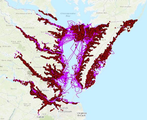
VIMS has an established program with the National Oceanic and Atmospheric Administration to recover lost or damaged crab traps, or pots, in the Virginia waters of the Chesapeake Bay. So far, over 34,000 pots have been recovered by Virginia watermen a significant step toward reducing stress on the crab population, bycatch of other species and hazards to navigation. VIMS realized that the tracks of the watermen’s vessels could provide useful soundings containing depth, latitude, longitude and time/date data. With 70 boats participating, VIMS was able to obtain over 3.6 million points of survey data over the course of a season.
Jane Batten, widow of Weather Channel founding owner Frank Batten, recently made a $100 million gift to create the Batten School of Coastal & Marine Science, which empowers VIMS research and public outreach programs In late 2023, members of the VIMS Foundation Board reached out to District 5 commanders Joe Gibson and his successor, Bob Blevins, to offer America’s Boating Club | United States Power Squadrons the opportunity to crowdsource shallow-water depth data that would improve the accuracy of VIMS’ SCHISM model, selected by NOAA as the most accurate way to monitor and improve the Chesapeake Bay area response to the impacts of climate change. In 2024, Delaware River and Northern Neck Sail & Power squadrons carried out a pilot program.
Structured surveys not required
The concept of crowdsourced sonar data is not new, with charting software like Navionics collecting boater-uploaded sonar information to provide higher-fidelity soundings and most likely machine learning to assess the accuracy of the uploaded data. But in this study, each boat was required to submit precise data regarding the transducer offset from both the waterline and GPS antenna to ensure that the data collected was based on a consistent datum. Transducers were set at the optimum ping frequency, and VIMS personnel showed each boater how to export the tracks collected.
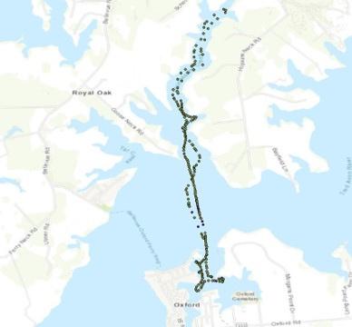
In the pilot program, teams of squadron boats went out to survey small bodies of water, conducted by running parallel track lines. In one day, they could generate a complete survey of a river or creek. VIMS learned that properly equipped boats could also take soundings at any time just by running about and uploading their data. The final step in the process was for each boater to register with the VIMS data collection portal so that stored bathymetry data can be shared as .gpx track line files that may be uploaded over the course of the season.

The future of the program
Now that the Northern Neck Sail & Power Squadron team has observed the setup process, it will be relatively straightforward to replicate with additional boats and squadrons. District 5 will be taking the program live in 2025, with all boats participating as they are able.
According to District Commander Bob Blevins, “This is a great opportunity for so many people. VIMS and the federal government get needed data for chart corrections but also for predictions of the effects of storm surge on fragile coastal areas. Our squadrons have a rallying cry to come together and work on a project of national impact, and the district can help raise the visibility of USPS for our work across the region."
Any data taken while boating on the Chesapeake Bay helps to improve the existing knowledge base for shallow-water bathymetry in the region. Eventually, VIMS hopes to expand the program to all the estuaries of the US. All squadrons and clubs are welcome to join the effort. ■
ABOUT THE AUTHOR
Gene A. Danko is a 35-year member of Rockville Sail & Power Squadron/5 and a life member of America’s Boating Club | United States Power Squadrons. He has been sailing the waters of the Chesapeake Bay for over 40 years as well as Narragansett Bay, Long Island Sound and various Caribbean destinations. His current project is Sundowner, a Mainship 34 trawler, which he affectionately refers to as “Queen of the Dock.”