FEASIBILITY REPORT
MARYLAND
LOT 6, BLOCK H BRADLEY HILLS GROVE
Prepared By:
Jeffrey A. Robertson CAS Engineering 10 South Bentz Street Frederick, Maryland 21701 301-607-8025 jeff@casengineering.com
Prepared For: David Fairbanks 6600 Bradley Boulevard Bethesda, Maryland 20817 (301) 908-1188 wdavidfairbanks@me.com / lisafamilyhome@gmail.com
Date: FINAL May 16, 2025
CAS ENGINEERING PROJECT NUMBER: 25-281

INTRODUCTION
The subject property (“property”) consists of Lot 6, Block H, Bradley Hills Grove, as per plat of subdivision recorded in Plat No. 5679 among the Land Records for Montgomery County Maryland (Appendix A). The property is also known as 6600 Bradley Boulevard and is situated at the northwest corner of Bradley Boulevard and Hillmead Road in Bethesda, Maryland. The property is bounded by the 100-ft wide Bradley Boulevard Rightof-Way to the east, the 60-ft wide Hillmead Road Right-of-Way to the south, and similarly developed residential lots to the north and west. The property is improved with an existing single-family dwelling (constructed in 1932 according to tax records), an outbuilding, and a circular driveway with access to each street.
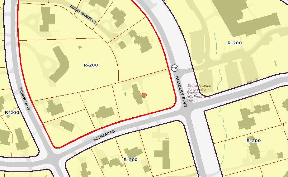
The property is currently zoned R-200 (see Zoning Map, Appendix B) and totals just over 1 acre (44,912 square feet) per deed recorded at Liber 22369, Folio 373 The Hillmead Road frontage totals approximately 264-ft (including portion of radius). The Bradley Boulevard frontage totals approximately 171-ft (including portion of radius). The Bradley Boulevard and Hillmead Road intersection is not signalized. There are no platted easements or encumbrances affecting the property. A title report was not provided nor reviewed.
There is no public storm drain infrastructure within the public rights-of-way or in the vicinity of the property. Public water, sewer and gas mains are located within the Bradley Boulevard and Hillmead Road Public Rightsof-Way adjacent to the property. These mains include 16” and 6” water mains, 8” sewer mains, and 12” and 6” gas mains. The existing house appears to be served by on-site well and septic systems, although no records were available from Montgomery County.
The property generally slopes from the northwest to the southeast towards the Bradley and Hillmead intersection at approximately 10-12%. Small areas of steep slopes (25% and greater) exist in the northwest corner and southeast corner. There do not appear to be any additional environmental features (streams, floodplains, wetlands, or 30-acre flow paths) within 100-ft of the property, per Montgomery County GIS Maps. The property does not appear to contain forest but does contain significant tree cover. Runoff from the property flows generally towards the southeast, along the east side of the Bradley Boulevard Right-of-Way, ultimately draining to Booze Creek. The property is located within the Booze Creek watershed.
This report will focus on aspects of County review as they pertain to an administrative subdivision application.
SUBDIVISION
The Montgomery County Subdivision Requirements (Chapter 50) apply to any proposed subdivision of the property. Newly created lots must meet applicable zoning requirements including, but not limited to, street frontage, width, area, and suitability for residential use.
Subdivisions involving up to three (3) lots for detached houses may be filed under the administrative subdivision plan application instead of a preliminary plan, if the following criteria is met:
1. The lots are approved for standard method development;
2. Written approval for any proposed well and septic area is received from the Department of Permitting Services, Well & Septic Section before approval of the plat;
3. Any required road dedications and associated public utility easements are shown on the plat and the applicant provides any required improvements;
4. The requirements for adequate public facilities under Section 4.3.J. are satisfied before approval of the plat; and
5. Forest conservation, stormwater management, and environmental protection requirements are satisfied before approval of the plat.
A two (2) lot subdivision of the property would be permitted under the administrative subdivision process which allows the Director of the Montgomery County Planning Department to approve or disapprove the proposed subdivision in writing. However, the Director may require that the proposed subdivision be acted on by the Board (Montgomery County Planning Board).
The attached Concept Plan (Appendix D) depicts a proposed two-lot subdivision Lots have been oriented to Hillmead Road due to the property’s larger frontage along the right-of-way. The existing house, garage, and appurtenances are assumed to be removed. Proposed Lot A is a corner lot measuring approximately 24,515 square feet with approximately 171-ft of frontage along Bradley Boulevard and approximately 144-ft of frontage along Hillmead Road (including the truncation / radius). Vehicular access (ingress / egress) is assumed to be provided along Hillmead Road, adjacent to the existing driveway. Proposed Lot B measures approximately 20,395 square feet with approximately 120-ft of road frontage along Hillmead Road Although two driveways exist for the property, vehicular access (ingress / egress) is assumed to be provided along Hillmead Road, adjacent to the existing driveway. Each lot would have its own driveway. Proposed building footprints shown on the Concept Plan are 3,000 square feet (approximately 6,000 square feet of living space on two floors), though larger footprints would be permitted. Each building footprint includes a two-car, attached garage.
ZONING
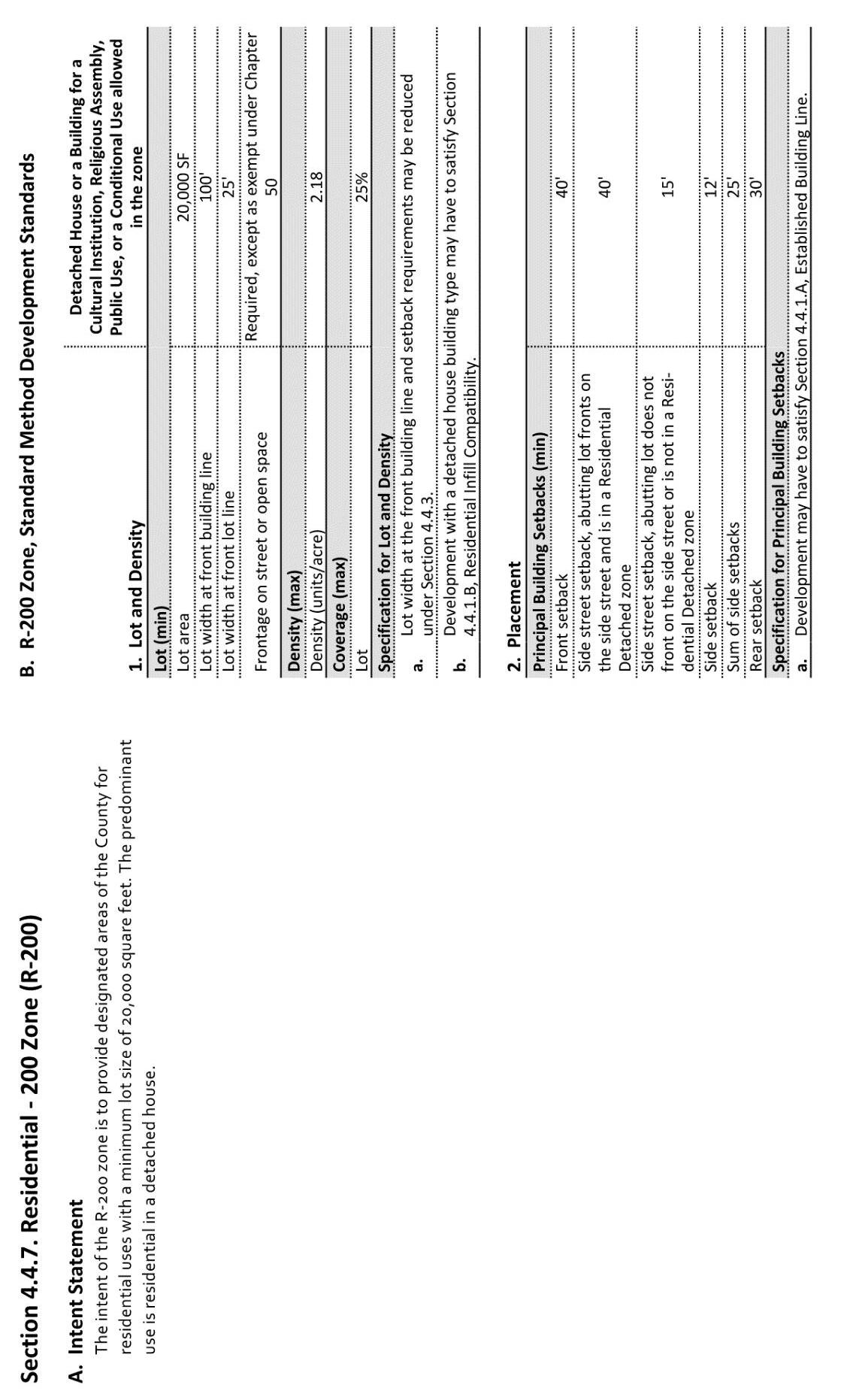
The property is currently zoned R-200 (Residential) A copy of the current zoning map is provided (Appendix B) Applicable zoning restrictions for standard method development are as follows:
Minimum Lot Area
Minimum Front Setback
Side Setback
Rear Setback
Lot Coverage
Minimum Lot Width at front building line
Minimum Lot Width at front lot line
20,000 square feet
40 feet 1
12 feet (minimum); 25 feet combined
30 feet
25%2
100 feet
25 feet
See Appendix C for an excerpt from the Montgomery County Zoning Regulations for the R-200 zone
Although the minimum front setback in the R-200 Zone is 40-feet, the proposed lots will be subject to an Established Building Line Survey at the time of building permit application. The Established Building Line is a
1 New lots will be subject to an Established Building Line Survey
2 New lots will be subject to “Residential Infill Development” criteria for new dwellings
calculated average of the front setbacks of all houses within 300-ft of the subject property. The Established Building Line applies along both streets for the corner lot. Based on a preliminary review of available County topographic information and arial imagery, the Established Building Line for Proposed Lot B would be the minimum for the zone, 40-ft, utilizing the well and/or septic exclusion for adjacent houses. The adjacent properties at 6515 and 6525 Hillmead Road were served by on-site wells and/or septic systems prior to the construction of public water and sewer mains. Proposed Lot A is considered a corner lot and as such, the Established Building Line criteria is utilized long each frontage The Established Building Line for Proposed Lot A along Bradley Boulevard has been estimated to be 49.8-ft. Along Hillmead Road, the Established Building Line is the minimum for the zone; 40-ft, based upon the well & septic exclusion. A formal Established Building Line Survey will need to be conducted and confirmed as part of the initial surveying effort for the subdivision
Pursuant to R-200 zoning regulations, the maximum lot coverage is 25%. However, new lots will be subject to Residential Infill Development criteria, resulting in a maximum lot coverage of 20% of the area of each proposed lot. Proposed Lot A would have a maximum lot coverage of 4,903 square feet and Proposed Lot B would have a maximum lot coverage of 4,079 square feet.
MASTER PLAN COMPLIANCE & RIGHT-OF-WAY DEDICATION
The 1990 Bethesda – Chevy Chase Master Plan does not specifically reference the subject property. General compliance with the goals and objectives of the master plan will be considered by MNCPPC. The plan has extensive language regarding the preservation of natural resources, such as wooded areas and mature trees.
The Transportation Plan section of the Master Plan references a minimum Right-of-Way width of 100-feet for Bradley Boulevard and its reclassification to an arterial road between the Capital Beltway and Goldsboro Road. The existing Hillmead Road Right-of-Way is not mentioned in the Master Plan. Its right-of-way width is 60-feet. Future dedications for rights-of-way are not anticipated as part of the subdivision process as both appear to be adequate in terms of master plan compliance.
The Transportation Plan section of the Master Plan recommends a pedestrian/bicycle path to be constructed within the existing 100-ft Bradley Boulevard Right-of-Way. The 2018 Bicycle Master Plan recommends both a bicycle side-path as well as a conventional bike lane on the north (or east) side of Bradley Boulevard and adjacent to the subject property.
The existing paved roadway (travel lanes) is not centered within the 100-ft Bradley Boulevard Right-of-Way and is located within a few feet of the subject property. Thus, there is little to no space for bike lanes or a side-path along the western portion of the right-of-way. The potential implementation of a bicycle path or conventional bike lanes will be considered in more detail during the administrative subdivision process. A minimum 10-ft Public Utility Easement (P.U.E) will be required along both public rights-of-way. The space may be utilized for utilities such as cable, electric, fiber optics, etc.
The potential subdivision of the property would generate fewer than 50 new person trips in the morning and evening peak hours. Therefore, Local Area Transportation Review (LATR) is not required. School facilities are assumed to be adequate, based upon the FY2024 Annual School Test.
MARYLAND STATE HIGHWAY ADMINISTRATION (MDSHA)
Bradley Boulevard (MD 191) is a State of Maryland Right-of-Way, maintained by MDSHA, whereas Hillmead Road is maintained by Montgomery County Department of Transportation (MCDOT). Proposed improvements and requirements along Bradley Boulevard will be reviewed by both MDSHA and MNCPPC (Maryland National Capital Park and Planning Commission) during the administrative subdivision process. Refer to “Adjacent Subdivision” section below.
COMPLETE STREETS
MCDOT together with MNCPPC have developed the Montgomery County Complete Streets Design Guide. The purpose of the design guide is to provide safe, accessible, and healthy travel for all users of the roadway system, including pedestrians, bicyclists, transit riders, and motorists. The recommendations of this guide, as they relate to both public rights-of-way, will be reviewed as part of the administration subdivision process.
VEHICULAR SIGHT DISTANCE
The subject property is currently served by a circular driveway with separate entrances; one along Bradley Boulevard and one along Hillmead Road. Sight distance studies / evaluations will be required at the proposed driveway locations on Hillmead Road or at any existing driveway to be retained. Sight distance requirements will be reviewed by MDSHA (for Bradley Boulevard) and MCDOT (for Hillmead Road) during the administrative subdivision process. Sight distance requirements and potential mitigation for non-compliant sight distances (clearing of right-of-way trees and/or vegetation, pole relocation, grading, among other possibilities) will be reviewed during the administrative subdivision process. Formal sight distance surveys will need to be conducted and approved prior to obtaining subdivision approval. Retaining the existing driveway along Bradley Boulevard may not be feasible due to existing sight distance imitations.
STORM DRAIN ANALYSIS, ROAD IMPROVEMENTS, SITE ACCESS
As part of the administrative subdivision application, the analysis of the public storm drain systems adjacent to the property will be required. If no public drainage infrastructure exists, roadside ditches and drainage paths will need to be evaluated. The analysis will determine if the existing system(s) are able to accommodate runoff from the proposed development. If the systems are determined to be inadequate, upgrades to the public systems could be required as a condition of subdivision approval. The property drains to the intersection of Hillmead Road and Bradley Boulevard. There does not appear to be any storm drain infrastructure in the immediate vicinity of the property. Therefore, an analysis of drainage channels, ditches and or curbs is likely to be required.
The requirement for public improvements within the Bradley Boulevard or Hillmead Road Rights-of-Way will be determined by MNCPPC, MCDOT, and MDSHA during the administrative subdivision process. At a minimum, new sidewalks and crosswalks will likely be required along Bradley Boulevard and Hillmead Road. Bus stop
improvements may be required. Improvement requirements are assumed to be similar to those required as part of the adjacent subdivision of 6540 Bradley Boulevard. Additional public improvements, such as bicycle paths, street buffers, and street trees could be required to satisfy the Bicycle Master Plan and the Montgomery County Complete Streets Design Guidelines Due to the steep slopes along the rights-of-way, a retaining wall will likely be necessary along portions of both rights-of-way.
WATER AND SEWER / UTILITIES
Based on available WSSC records, the existing house does not appear to be connected to either public water or sewer. According to communications with the Montgomery County Well & Septic Section, the house is served by on-site well and septic systems. No records were available relative to the locations of the on-site systems. Although the existing house is served by on-site well and septic systems, the property is located within a W-1 water service category and an S-1 sewer service category. Service categories denoted with the number “1” are areas currently being served by existing public water and/or public sewerage systems. Available WSSC plans indicate an existing 16” water main in the Bradley Boulevard Right-of-Way and an existing 6” water main in the Hillmead Road Right-of-Way.
New water and sewer service connections will be required for each of the proposed houses Connections would be provided from mains within the Hillmead Road Right-of-Way. No mainline extensions will be required as part of the subdivision process.
Based upon available information Washington Gas, gas mains exist in both the Hillmead Road and Bradley Boulevard Rights-of-Way. If gas service is desired for the proposed houses, a service connection request can be submitted during the building permitting phase of the project. The potential for new gas service connections will be reviewed during the administrative subdivision process
Electric service exists via overhead lines and power poles along the opposite sides of Bradley Boulevard and Hillmead Road. New service connections for each house will be served via new underground connections from adjacent power poles. Service connections may be pursued during the building permit phase.
SOIL CONDITIONS
According to the USDA National Cooperative Soil Survey, the property is expected to be composed mainly of Neshaminy silt loam soils. These soils are well-drained and characterized by a fine-loamy texture and generally used for agricultural purposes. They have moderate permeability with medium runoff. Infiltration testing for stormwater management design will be required as part of the Stormwater Management Concept Plan and administrative subdivision application.
STORMWATER MANAGEMENT
In accordance with State of Maryland and Montgomery County regulations, stormwater management requirements will apply to the proposed administrative subdivision. A Stormwater Management Concept Plan and Application will be required for review and approval during the subdivision process. Stormwater management devices will be required for both proposed houses. These devices may include drywells, rain
gardens, landscape infiltration devices, micro bioretention / planter box facilities, and permeable pavements, among others. Approval by the Montgomery County Department of Permitting Services (MCDPS) Water Resources Section is required prior to recording the new lots. As mentioned previously, soil infiltration testing will be required. A report containing the results of the testing is required and will be included as part of the Stormwater Management Concept Plan review and approval process. Poor infiltration rates or soil conditions may require the design of planter boxes / micro bioretention devices for the properties.
ENVIRONMENTAL / FOREST CONSERVATION
Subdivision applications are subject to the Montgomery County Forest Conservation Law. A separate and concurrent Forest Conservation Plan application will be required as part of the subdivision process. Per Montgomery County environmental maps, no forest exists on the property. However, the majority of the property does contain tree canopy. Several specimen trees (typically, those measuring 30-inches or more at 4.5’ about the ground) are present and will be impacted or removed as a result the proposed development. A specimen tree variance may be required. Removal of specimen trees is typically permitted with acceptable justification. Mitigation for the removal of specimen trees (and in some cases for the removal of significant trees (those >/= 24 inches)) will be required. Protection of individual trees, especially those located along the perimeter and on adjacent properties, will be required. Forest Conservation exemptions may be approved for qualifying projects. Otherwise, forest conservation requirements will involve the purchase of an off-site forest easement or a fee in lieu payment. Fee in lieu payments are currently $1.45 per square foot of forest afforestation or reforestation. Existing forest areas, steep slopes, and other environmental criteria will be subject to review and approval by MNCPPC prior to the approval of the subdivision application
According to available Federal Emergency Management Agency (FEMA) floodplain maps, there are no portions of the property impacted by 100-year FEMA floodplains. Based on MCDPS GIS Maps, there are no flowlines depicting drainage areas of 30 acres or more in the project vicinity. Therefore, neither a floodplain analysis nor a floodplain delineation study are anticipated as part of the subdivision review process. A Natural Resources Inventory / Forest Stand Delineation Plan will be required prior to the Forest Conservation Plan process.
FIRE DEPARTMENT ACCESS
As part of the administrative subdivision application, MCDPS staff will review the project for Fire Department access and for water availability requirements. Given the availability of public water mains, obtaining approval for adequate water availability is likely. The Hillmead Road and Bradley Boulevard pavement widths both appear to be 20-ft or greater, therefore approval for fire department access is also likely.
DEVELOPMENT IMPACT TAX
New residential and commercial building construction projects are subject to Development Impact Taxes, created by the Montgomery County Council. These taxes fund transportation improvements as well as expansion of the public school system within Montgomery County. Development Impact Taxes totaling approximately $45,000 (or more) would apply to Proposed Lot A. No Development Impact Taxes would apply
Proposed Lot B due to the existing house residing primarily on the lot. The exact impact tax fee will be determined at the time of building permit issuance.
ADJACENT SUBDIVISION
Based on available public information, the confronting property (6540 Hillmead Road) was subject to a recently approved Administrative Subdivision Application (620230110). Due to proximity to Bradley Boulevard, increased building setbacks were required along the Bradley Boulevard Right-of-Way to address noise requirements. According to the MNCPPC Staff Report, recommended building setbacks of 70-ft along Bradley Boulevard will also help to address perpetuation of the existing community character as desired by the Master Plan and will help to address noise mitigation by setting the new residences further from the roadway source, thereby diminishing noise impacts. The minimum front setback from Bradley Boulevard was 70-ft for both lots.
Additionally, a noise analysis was required as part of the building permit process. Windows and doors with increased noise mitigation ratings may be necessary as part of the permitting process. The use of noise walls or berms was not recommended.
Neighbor concerns prompted an increased rear setback from 30-ft to 40-ft. Both proposed lots have primary frontage along Bradley Boulevard with their rear yards along the property’s western limits. Additional setbacks and the planting of vegetation assuaged both neighbor’s opposition.
The construction of a minimum 8-ft wide street buffer and a 6-ft wide sidewalk were required along the Hillmead Road frontage. Along the Bradley Boulevard frontage, a 6-ft street buffer and 6-ft wide sidewalk were required. Based upon the location of the existing travel lanes, the sidewalk and street buffer along Bradley Boulevard appear to be located on the subject lots and within a 13-ft wide public improvements easement (PIE). As a result, no additional dedication was required.
CONCLUSIONS / RECOMMENDATIONS
A proposed two-lot subdivision of the existing 44,912 square foot lot appears viable with a reasonable probability for approval. The subdivision appears to meet the applicable R-200 zoning requirements for lot size, setbacks, frontage, and lot coverage Should additional dedication along Bradley Boulevard and/or Hillmead Road be required, then the total lot area available for a 2-lot subdivision will need to be reevaluated as the minimum lot area is 20,000 square feet. MNCPPC Staff should be consulted for a determination of dedication requirements prior to a formal subdivision application The adjacent subdivision involved a smaller lot measuring 42,351square feet with two proposed lots oriented to Bradley Boulevard. No additional dedication was required It is reasonable to assume a similar subdivision of the subject property would be approvable.
Adequate sight distance must be confirmed by State and/or County Staff depending upon ultimate driveway locations The need for right-of-way modifications to achieve acceptable site distances, such as roadside tree / vegetation removal, and on-site grading could be required conditions of approval. Re-use of the
existing driveway aprons to serve one or both proposed lots may be considered. A formal sight distance survey / evaluation and possible review by appropriate agencies is recommended prior to beginning a subdivision process.
Based on available public information from a recent development project involving the confronting property (Administrative Subdivision Application No. 620230110), increased setbacks, above those required by R-200 zoning and the Established Building Line criteria, may be required along the Bradley Boulevard Right-of-Way Increased setbacks are intended to mitigate noise from Bradley Boulevard and preserve vegetation. A similar setback of 70-ft from Bradley Boulevard would reduce the buildable area of Proposed Lot A and would likely require a narrower building footprint with a front-loaded garage. However, a 3,000 square foot (or more) footprint remains feasible. Conducting a noise study in advance of the subdivision application is recommended in an effort to negotiate a reduction in the potential 70-ft setback. Options for mitigating noise within the building may be proposed as part of the subdivision application rather than deferring to building permit stage.
Similar requirements for sidewalks and street buffers are likely to be required as part of an administrative subdivision. Surveyed locations of the existing travel lanes will dictate sidewalk locations and the limits of a public improvement easement. In addition to a possible PIE, an additional (or overlapping) public utility easement (PUE) will be required. Hence, a 6-ft PIE and a 16-ft PUE have been reflected on the Concept Plan.
Conformance with the Bethesda - Chevy Chase Masterplan and Bicycle Master Plan appears to be achievable with public improvements within the Bradley Boulevard and Hillmead Road Rights-of-Way likely required. Such improvements may include sidewalks, cross walks, street buffers, bike lanes, etc.
Fire Department approval for access and water services appears to be achievable. The ability to connect to public utilities (water, sewer, gas, and electric) also appears to be feasible as services mains are present along both rights-of-way.
To address Forest Conservation and the Environmental Guidelines, protection of mature trees in proximity to adjacent private properties will be prioritized. Impacts to and removals of specimen trees may necessitate a Specimen Tree Variance. Tree mitigation for the removal of specimen and/or significant trees will be required The payment of a “fee in lieu” for afforestation / reforestation will be required if a forest conservation exemption is denied. The payment will be required prior to the recording of the new lots, if conditioned as part of the subdivision process The estimated fee in lieu payment is $1.45 per square foot ($12,000.00).
Stormwater Management is required and will likely involve drywells, permeable pavement, landscape infiltration, and/or micro bioretention/planter box facilities Other devices may be applicable and will be reviewed during the Stormwater Management Concept Plan and Administrative Subdivision Plan phase. Soil infiltration testing will be required and should be performed prior to any subdivision design. In the event of less than favorable infiltration rates, devices such as micro bioretention facilities and planter will be required.
Prior to the application for subdivision, a Natural Resources Inventory / Forest Stand Delineation Plan must be approved. This plan will confirm the existing environmental conditions affecting the property (forest, streams, steep slopes, large diameter trees, etc.) and will serve as the basis for the subdivision plans.
Subdivisions of this nature typically range from $70,000 to $90,000 for surveying, engineering design, and soil testing. County review fees range from $10,000 to $15,000. The administrative subdivision process (including the Natural Resources Inventory / Forest Stand Delineation Plan) takes approximately 10-12 months to complete. Once the subdivision is approved, the lots will need to be formally recorded via the Record Plat process. Typical record plat review and approval time is 4 to 5 months Possible conditions of subdivision approval such as right-of-way improvements, payment of forest conservation fees, on-site planting fees, etc., will need to be addressed during or prior to the Record Plat process. A demolition permit for the existing dwelling will also be required prior to record plat approval.
Once the lots have been recorded, building permits may be issued for the new homes. Architectural and Structural Plans as well as Final Civil Engineering Plans will be required for building permit review and approval. Payment of impact taxes typically occurs within 6 months of permit issuance.
While a subdivision of the subject property to create two lots appears feasible, the approval of a subdivision is not guaranteed. The preparation and submittal of a Concept Plan Application prior to a subdivision application is an option. In conjunction with the Concept Plan, the preparation and confirmation of an Established Building Line Survey and a Sight Distance Evaluation are also recommended. Although Concept Plans are not formally approved by MNCPPC, comments provided offer valuable guidance for the developer and the engineer. The attached Concept Plan may be utilized for submittal and feedback.
APPENDIX A – RECORD PLAT (PLAT 5679)
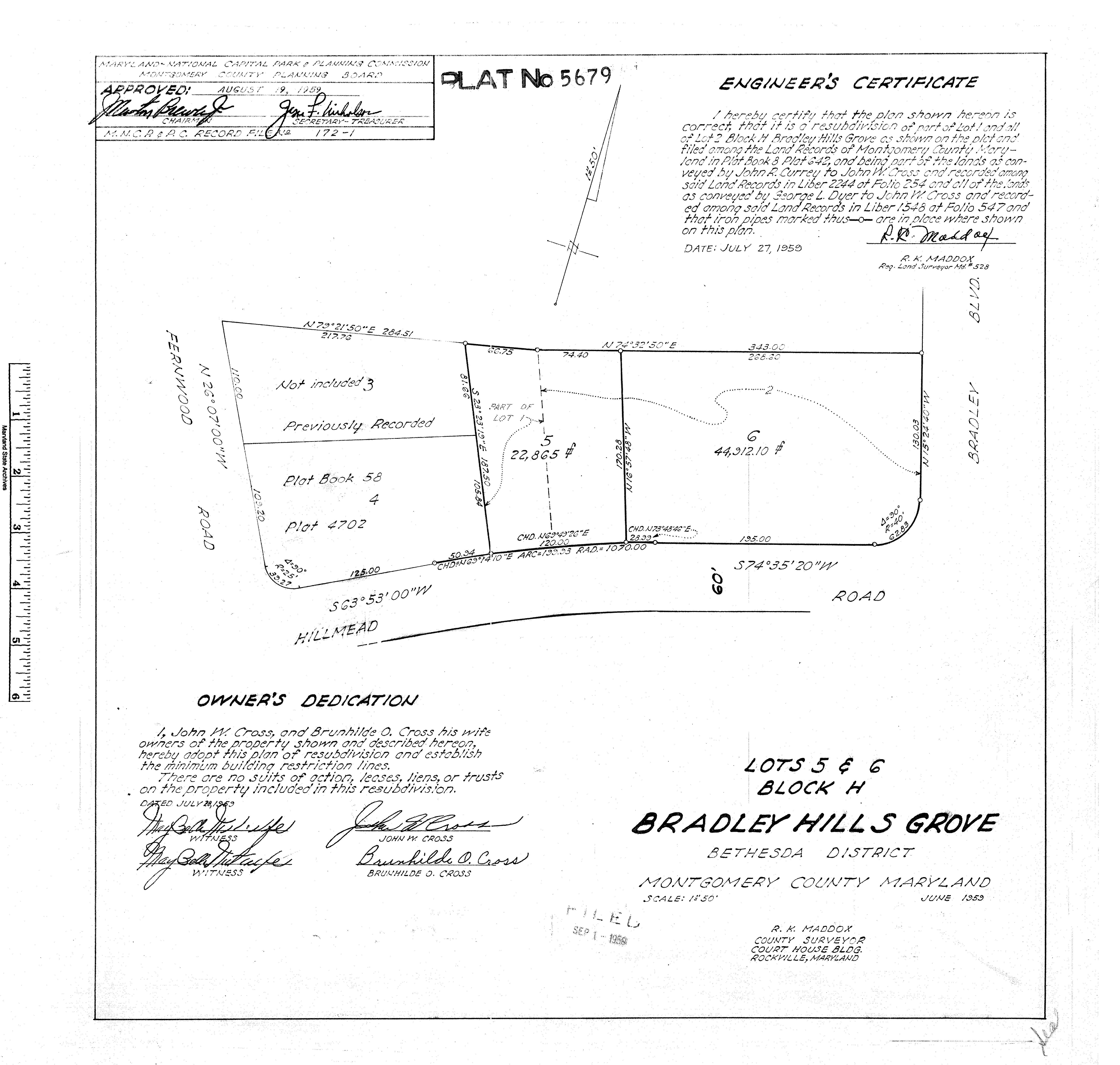
COUNTY CIRCUIT COURT (Subdivision Plats, MO) Plat 5679, MSA_S1249_13494. Date available 1959/09/01. Printed 04/15/2025.
APPENDIX B - ZONING MAP
Montgo me r y Cou nty Zo nin g
Date: 4/14/2025

APPENDIX C- DEVELOPMENT STANDARDS FOR R-200 ZONE