
Brandywine
Analysis of Potential Floodplain Restoration and Dry Dam Flood Control Facility Sites
April 2025
PREPARED BY Brandywine Conservancy
Chester County Water Resources Authority University of Delaware Water Resources Center


Section 9 Analysis of Potential Floodplain Restoration and Dry Dam Flood Control Facility Sites
9.1 Exploring Sites for Larger-Scale Flood Mitigation Projects
In addition to retrofitting or upgrading existing infrastructure (i.e., bridges, flood control facilities, etc.), the Flood Study team explored numerous sites throughout the watershed to evaluate their potential for large scale flood mitigation projects, including floodplain restoration/reconnection and the installation of new “dry dam” flood control facilities. The focus of this effort was to identify sites that could provide both flood storage and reduction in peak discharge during major flood events, particularly upstream of historically flood-prone communities.
The level of analysis completed for each site varied depending on individual characteristics. Generally, the site analysis fell into one of the following categories:
• Preliminary desktop analysis (used to screen out sites where further modeling was unnecessary), including reviews of topography, total drainage area, proximity to development and/or critical infrastructure, and available data for flow and discharge rates.
• Hydrologic and hydraulic (H&H) modeling of one or more flood mitigation scenarios on the site, to better assess the potential for a reduction in flood elevations and peak discharges.
While the findings from each site analysis should be considered as preliminary, they have each been assigned one of the following recommendations for next steps:
• Recommended for implementation
• Recommended for further analysis
• Not recommended for implementation (either due to lack of potential regional impact or due to considerable constraints uncovered during preliminary analysis)
Technical experts from Meliora Design and Gannett Fleming provided assistance with the site review and related H&H modeling.

Left photo: Beaver Creek Dry Dam in East Brandywine Township.
Right photo: Beaver Creek Dam after Hurricane Ida (September 2021)
9.2 Review of Site Analysis for Floodplain Restoration Opportunities
The project team identified and assessed numerous sites in the watershed for floodplain restoration potential. Floodplain restoration that is focused on downstream flood reduction involves providing additional storage for out-of-bank flooding of the adjoining floodplains, as well as providing for slower rates of these out-of-bank flows, so that the water does not race through to downstream communities. Floodplain restoration will often have small wetlands or depressions in the floodplains, which provide additional storage and even shallow groundwater infiltration following storms.
The following sites were analyzed for floodplain restoration opportunities with flood mitigation potential using H&H computer models.
Brandywine Conservancy Properties Chadds Ford Township Main Stem Brandywine Creek Floodplain restoration/ Legacy dam removal
Recommended for implementation
Modeled Single property owner; wide & flat floodplain; potential to complement other structural projects (including bridge replacement/removal and dam removal)
As presented in the full report, floodplain restoration is recommended for implementation on properties owned by the Brandywine Conservancy along the main stem in Chadds Ford Township. This work could serve to complement and enhance other flood mitigation efforts in the immediate area, including the removal of legacy bridges and dams that contribute to backwater flooding during major storm events.

Figure 9.1 Brandywine Conservancy Area of Analysis
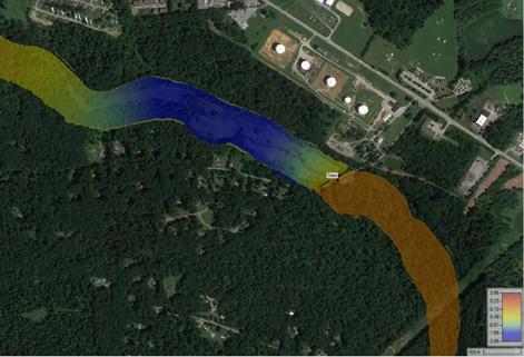
Brandywine Conservancy owns roughly 122 acres of undeveloped floodplain around its campus in Chadds Ford, PA. This land has been considered for floodplain restoration. H&H computer models were used to simulate lowering the floodplain on those parcels by approximately four feet. In addition, there is an existing dam on the Brandywine slightly upstream of the Route 1 bridge that is currently breached and slated to be removed. Removal of the dam was included in the proposed conditions model.
Based on the preliminary modeling results, the proposed floodplain restoration project has the potential to lower the water surface elevation for the 1% annual chance flood, including lowering the water surface elevation, by roughly 0.5-0.8 feet at the Brandywine Museum of Art, and surrounding structures in Chadds Ford.
However, upstream of Route 1, there is not much development in the floodplain, with only 5 structures and one paved road (Creek Road). The modeling analysis suggests prioritizing floodplain restoration on the parcels downstream of Route 1 would be more impactful in reducing flooding of structures in Chadds Ford.
In addition to the decrease in water surface elevation, the downstream peak discharge would be reduced by 73.5 cfs, or 0.25% of the 1% annual chance peak flow. In addi on to the decrease in water surface eleva on, the downstream peak discharge would be reduced by 73.5 cfs, or 0.25% of the 1% annual chance peak ow.


Figure 9.2 Brandywine Conservancy Area of Analysis & Estimated Change in Maximum WSE at the 1% Annual Chance Flood
Figure 9.2 Area of Analysis & Es mated Change in Maximum WSE at the 1% Annual Chance Flood
Icedale Lake Honey Brook and West Brandywine Townships
West Branch Brandywine Floodplain restora on/ Storage capacity improvements
Further analysis recommended Modeled Exis ng (breached) dam at the site; opportuni es for further analysis with municipal bridge replacement planning
The Icedale Road site includes an existing bridge and dam remnant near Honey Brook along the West Branch of the Brandywine. The area is within the FEMA-delineated Special Flood Hazard Area (SFHA) Zone A floodplain. However, the area is not mapped using a detailed computer model. The potential site is roughly 23 acres, spanning the area of the old reservoir. A bridge just downstream of the lake is currently slated for replacement. The proposed bridge plans were used to run the model. Since there was no detailed FEMA model along this stretch of the stream, the bathymetry was estimated based on the average slope of the FEMA bathymetry upstream of the site’s stream reach. Models were used to estimate the impact of the removal of four feet of sediment in the floodplain.
Removing floodplain material greatly reduces the 1% annual chance flood peak water surface elevation upstream of the bridge. However, this floodplain area is not developed, so there is no immediate potential impact to life and property. In spite of this, further analysis could be warranted as part of the bridge replacement project to assess alternatives at the site that were beyond the scope of this study.

9.3 Icedale Area of Analysis & Estimated Change in Maximum WSE at the 1% Annual Chance
Figure
Mary Street Riparian Corridor Downingtown Borough Beaver Creek Floodplain/ Streambank restoration
Further analysis recommended Modeled Potential to complement other structural projects (including bridge replacement)
The Borough of Downingtown experiences significant flooding from both the East Branch Brandywine and Beaver Creek. The site analyzed for this study is on land owned by the Archdiocese of Philadelphia adjacent to Beaver Creek that is in the 1% Annual Chance (100-year) FEMA floodplain. This area is adjacent to development on Mary Street and Stuart Avenue. At this site, H&H models were used to assess the potential impact of 11 acres of floodplain restoration where the floodplain area was lowered 4 feet and the terrain in the channel was modeled to be 1 foot lower than its current elevation.
Lowering this portion of the floodplain resulted in a modeled reduction of flooding at Mary Street for smaller storm events. Reduction of water surface elevation at the 1% Annual Chance Flood ranged from 0.257 to 0.776 ft below existing conditions in rows of houses in the floodplain. At the 10% annual chance flood, the reduction ranged from 0.25 to 1.87. It is possible that the reduction in water surface elevation could prevent homes from being flooded, however, the first floor of each structure has not been surveyed as part of this study. The project will not noticeably change the peak flow downstream, as the model estimates that only 3 cfs will be reduced from the peak flow out for the 1% annual chance flood.
This project on its own would not likely have significant positive impacts for local residents on Mary Street during major flood events. However, further analysis is warranted to explore coupling a floodplain restoration project, which may help address flooding from smaller scale storms, with upgrading the bridge on Manor Avenue in Downingtown, which would provide greater flood mitigation during larger storms.


Figure 9.5 Change in maximum water surface elevation at Mary Street at the 1% Annual Chance Flood

9.6 Change in maximum water surface elevation at Mary Street at the 10% Annual Chance Flood
Figure
Site
Wedgewood at Valley Run/Beaver Creek
Conuence
Level of Analysis Analysis Details
Caln Township Beaver Creek Floodplain/Stream restoration Further analysis recommended Modeled Potential to complement other projects and address concerns related to sediment mobilization and pond embankment stability
The study assessed a 32-acre site located near the confluence of Valley Run and Beaver Creek, including a large pond adjacent to the Wedgewood development complex, for floodplain restoration potential. Currently, portions of this site are slated for redevelopment, which may include remediation. For this model analysis, 6 ft. of floodplain material was removed for the entire site. Possible flood reduction in the residential complex, and along G.O. Carlson Road, which is the only access point into the complex, was assessed.
The modeling results show a significant decrease in the water surface elevation along Valley Run above its confluence with Beaver Creek (4.6-3 ft reduction). While no buildings appear to be impacted by these reductions in the 100-yr flood elevations, there were some reductions in the adjacent parking lot (~0.3 ft reduction). This effect lessens at the development entrance at G.O. Carlson Road (0.05 ft). Additionally, there is a small reduction in the downstream peak flow of 23.77 cfs, which is only 0.44% of the 1% Annual Chance Peak Flow.
While impacts from floodplain restoration on this site are likely to be minimal, further analysis may be warranted to assess other types of restoration work that is beyond the scope of this study. Notably, a 2007 study completed by Land Studies, Inc. on behalf of Caln Township, outlined opportunities for floodplain restoration coupled with stream realignment and the conversion of the existing pond into a floodplain wetland. This could have potential benefits beyond flood mitigation, including a reduction in both sediment loads and the risk of bank failure between the pond and Beaver Creek.

Figure 9.7 Valley Run/Beaver Creek Confluence FEMA FIRMette

Figure 9.8 Change in maximum WSE at Wedgewood at the 1% Annual Chance Flood Site
Brandywine Picnic Park (Lenape Park)
East Bradford and Birmingham Townships
Main Stem Brandywine Creek Floodplain restoration/ Storage capacity improvements Not recommended –minimal regional impact
Modeled Area is already in the oodplain and relatively low and at; minimal opportunity for storage or to reduce peak ow
Lenape Park, which used to be known as Brandywine Picnic Park, is located along the main stem of the Brandywine Creek near PA Route 52. The area used to operate as an amusement park, but remaining structures on site are in poor condition due to flood damage. Adjacent to the site, there is a dam that is proposed to be removed, which was included in the proposed model conditions. The H&H model was run under a scenario that included the removal of 4 ft. of floodplain material across the 20-acre site (along with the removal of all on-site structures). There are 21 structures upstream of the park on both sides of the Brandywine. These are all located adjacent to the Brandywine Creek in the FEMA Floodplain.
Modeling results indicate that the peak 1% annual chance maximum water elevations at the upstream structures were lowered 0.55 to 0.96 ft., with the larger change being at the structures closest to the dam and the park. However, as these structures are right on the stream bank, the nearby houses would still be under around 4 ft. of water in the proposed model conditions, providing a negligible benefit to life and property.
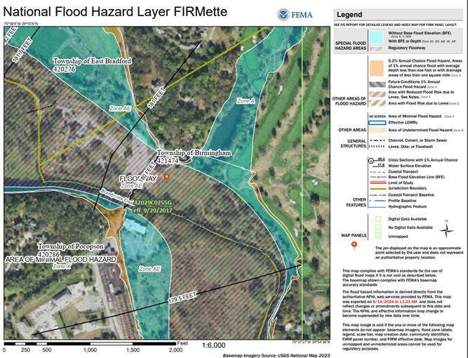

Figure 9.9 Brandywine Picnic Park FEMA FIRMette
Figure 9.10 Change in maximum WSE at Brandywine Picnic Park at the 1% Annual Chance Flood

Figure 9.11 Estimated maximum depth around Brandywine Picnic Park at the 1% Annual Chance Flood
The following sites were given a preliminary desktop analysis to assess floodplain restoration opportunities with flood mitigation potential. Ultimately, none were recommended for implementation due to minimal anticipated impact on regional flooding. Details about factors which led to that determination are provided in the following table.
Site Municipality
Manor Road/Kings Highway City of Coatesville
Caln Woodlands
Caln Township
Creek Road above Downingtown East Brandywine Township
East Fallowfield Park
Ingleside Golf Course
Johnsontown Park
East Fallowfield Township
Watershed Concept
West Branch Brandywine
Beaver Creek
Floodplain restoration/storage capacity improvements
Floodplain/Streambank restoration
East Branch Brandywine
Dennis Run
Caln Township Valley Run
Downingtown Borough East Branch Brandywine
Floodplain restoration/storage capacity improvements
Floodplain restoration/storage capacity improvements
Floodplain/Streambank restoration
Floodplain/Streambank restoration
Details
Upstream drainage area is too large for the size of the site; minimal opportunity for storage or to reduce peak flow
Area is already in the floodplain and relatively low and flat; minimal opportunity for storage or to reduce peak flow
Area is already in the floodplain and relatively low and flat; minimal opportunity for storage or to reduce peak flow
Small drainage area; existing retention facilities on site
Small drainage area; relatively flat terrain for storage potential
Upstream drainage area is too large for the size of the site; minimal opportunity for storage or to reduce peak flow
Paradise Valley Nature Area
Parkside Soccer Fields
Poorhouse Road Reservoirs
South Coatesville on Dennis Run
Tabas Memorial Park
East Bradford Township Valley Creek
Downingtown Borough East Branch Brandywine
West Bradford Township
South Coatesville Borough
Beaver Creek
Floodplain/Streambank restoration
Floodplain/Streambank restoration
Floodplain restoration/storage capacity improvements
Area is already in the floodplain and relatively low and flat; minimal opportunity for storage or to reduce peak flow
High point in local area; very small natural drainage area
Area is steep and narrow; limited opportunity for storage or to reduce peak flow without compromising critical infrastructure
Dennis Run
Floodplain restoration/storage capacity improvements
Downingtown Borough East Branch Brandywine
Floodplain restoration/storage capacity improvements
Limited potential to positively impact downstream flooding, which is driven by the West Branch Brandywine as opposed to by Dennis Run
Area is already in the floodplain and relatively low and flat; minimal opportunity for storage or to reduce peak flow


Figure 9.12 Sites Assessed for Floodplain Restora on Poten al
Figure 9.12 Sites Assessed for Floodplain Restoration Potential
9.3 Review of Site Analysis for Dry Dam Flood Control Facilities
Dry dams are flood control structures that only activate during flooding conditions. This means that there is no permanent reservoir or standing pool behind the dam. During normal or dry weather conditions, the stream moves naturally through the channel without any impediments to flow or fish passage. During intense precipitation, the structure of the dam holds back floodwater and allows it to be released downstream at a controlled rate. These flood control facilities can be implemented at a variety of scales, depending on the size and topography of the drainage area above the structure, anticipated discharge during storm events, the underlying geology of the site, and other factors.
Several sites throughout the watershed were analyzed to determine their suitability for dry dams to mitigate downstream flooding. Ultimately, none of the sites were recommended for further analysis. In most cases, this was because there was insufficient space (either due to topography constraints, existing development, or both) to create enough flood storage to meaningfully reduce flow rates during major storms.
Only the site along the West Branch above Valley Station Road, near Coatesville, moved beyond a preliminary desktop analysis to include H&H scenario modeling. Details of that analysis are provided below.
West Branch above Valley Station Road Coatesville
West Branch Brandywine
Not recommended - minimal impact for watershed flow rate reduction
Modeled
Upstream drainage area is too large for the size of the site; minimal opportunity for storage or to reduce peak flow without significant upstream property easements or acquisitions
The site above Valley Station Road north of the City of Coatesville was initially selected because of its proximity to the downstream area, and relatively minimal development in the adjacent floodplain. A portion of the site had formerly been inundated as the result of a mill pond, with the associated waterbody known as Lake Kurtz. Modeling results indicated that, while a dry dam at this site could be possible, the scale at which it would need to be built in order to provide meaningful reductions in peak flood discharges for downstream residents would require the acquisition of dozens of upstream properties (potentially more than it would protect). It would also risk inundating major roadways and critical infrastructure. As such, the concept was ultimately not recommended for further analysis or implementation.


Figure 9.13 Eleva on-Volume Curve for Flood Storage at the West Branch Site
Figure 9.13 Elevation-Volume Curve for Flood Storage at the West Branch Site

Figure 9.14 Inunda on Map of Flood Storage Pool for Structure with Top of Dam at 380 feet above Valley Sta on Road
Figure 9.14 Inundation Map of Flood Storage Pool for Structure with Top of Dam at 380 feet above Valley Station Road

Figure 9.15 Inunda on Map of Flood Storage Pool for Structure with Top of Dam at 400 feet above Valley Sta on Road
Figure 9.15 Inundation Map of Flood Storage Pool for Structure with Top of Dam at 400 feet above Valley Station Road
The remaining sites were given a preliminary desktop analysis to assess their potential for the installation of a dry dam flood control structure. Ultimately, the study did not recommend any sites for implementation due to minimal anticipated impact on regional flooding. Details about factors which led to that determination are provided in the following table.
Site Municipality Watershed
Buck Run near Laurel Forge Road Newlin Buck Run Not recommendedinfeasible
Dennis Run near Hephzibah Road East Fallowfield Dennis Run Not recommendedminimal impact for watershed flow rate reduction
Preliminary Land use and ownership restrictions likely prohibit such uses
Preliminary Limited potential to positively impact downstream flooding, which is driven by the West Branch Brandywine as opposed to by Dennis Run
Embreeville near Brandywine Drive Newlin West Branch Brandywine Not recommendedminimal impact for watershed flow rate reduction
Off Buck Road near Rte. 322 East Brandywine Beaver Creek Not recommendedminimal impact for watershed flow rate reduction
Unnamed Trib below Chester County Public Safety Training Campus South Coatesville West Branch Brandywine Not recommendedminimal impact for watershed flow rate reduction
Unnamed Trib near Union Street South Coatesville West Branch Brandywine Not recommendedminimal impact for watershed flow rate reduction
Preliminary Storage potential is greater than at other areas explored, but not large enough to provide significant benefits to downstream developed areas
Preliminary Drainage area too small to create meaningful flood storage
Preliminary Drainage area too small and terrain too steep to meaningfully create flood storage
Preliminary Drainage area too small and terrain too steep to meaningfully create flood storage