
tomorrow,TheThamesmead:andExtendingMendingtownoftoday Option Studio / Fall 2021

Studio Instructor Kathryn Firth Teaching Assistant Sai Joshi Students Eun Soo Choi, MLA Shannon Guo, MAUD Natasha Harkison, MLAUD Deqian Huang, MArch Zeqi Liu, MLA Austin Lu, MLA Avi Robinson, MArch Oliver Shi, MLA Erin Soygenis, MAUD Sovor Zhou, MLA Guangya Zhu, MLAUD
Students studied what holistic resiliency means in the context of an isolated district that will soon have better transport links to the metropolis of London. The scale of Thamesmead Waterfront had the potential to tackle all-encompassing challenges post COVID-19: climate change, social inclusion, diversity, diverse models of living and working, changing commuter patterns, infrastructure in a currently suburban opportunity to meet, work with and hear from local school students, the professionals that represent the diverse disciplines on the development and consultant teams and local government planners.
Extending and Mending Thamesmead: The town of tomorrow, today This studio investigated what it means to extend and mend a ‘new town’. Students explored the many physical and social edge conditions and tensions that arise when the new meets existing populations and places. Students were asked to consider what qualities distinguish a place as urban or suburban. As the boundaries between work, learning and living have blurred geographically and spatially over the past 18 months do characterizations of urban and suburban still make sense?
Studentscontext.hadthe
Preface 9 Studio Introduction Kathryn Firth Contextual History and Site Introduction 15 Historical Context 17 Movement Infrastructure 19 Environment and Open Space 21 Community and Culture 23 Ethnography and Demographics 25 Management and Stewardship 27 Policy and Jurisdictions Case Studies 31 Letchworth Garden City 33 Hampstead Garden Suburb 34 Cerge Pontoise 37 Radburn Community Engagement 41 Map your Day 43 Dot Polling 45 Draw your Thamesmead Projects 49 The Thamesmead Islands Oliver Shi, Eun Soo Choi, Shannon Guo 53 Island of Healing Eun Soo Choi 63 Island of Living Oliver Shi 69 Island of Trading Shannon Guo 79 Misplaced Resources De Qian Huang, Zeqi Liu 93 Thamesmead Districts Austin Lu, Guangya Zhu, Sovor Zhou 97 A Home for Cultural Legacy Austin Lu 107 Thamesmead District Guangya Zhu 115 Thamesmead Revitalization Sovor Zhou 123 Living in Water Erin Soygenis 137 Thamesmead on the Map Natasha Harkison
9Preface


The Past “ It was a good place to be as a kid. There was so much nature and wide-open space. In the spring there would be grass fights, in the summer there’d be water fights, in the autumn would be mud bombs and winter would be snowballs.”Philip Samuel, Thamesmead resident, 1975. In the mid-1960s, a vast concrete housing estate began to rise out of neglected marshland on the south bank of the River Thames. Headed by the Greater London Council, the scheme intended to solve the post-war housing crisis, and was heralded as visionary. Its design was both an architectural and urban experiment: concrete townhouses, blocks of apartments and elevated walkways were all built around a system of lakes, canals and parkland. Architects, sociologists and politicians all turned their attention to the transformation of a marshland into the ‘town of Intomorrow’.thebeginning, the estate was so exclusive that families had to be vetted to get a home there. However, there were real hardships and difficulties for these early pioneers. The slow development of local infrastructure, leaking concrete buildings and, most importantly the failure to provide the new township with efficient transport links started to erode Thamesmead’s shiny new image. In 1971 Thamesmead provided a backdrop to Stanley Kubrick’s seminal film, A Clockwork Orange. The abolishment of the GLC 1986 and ongoing lack of investment and management meant a continual slide into disrepair, crime, and marginalization over the subsequent three decades. Attempts to address the early signs of discontent resulted in the demolition of some of the original town’s signature landmarks and new buildings that were far more architecturally traditional resulting, according to architectural journalist Owen Hatherley, in a ‘straggling half-demolished mess of crap spec housing, wasteland and forlorn Brutalist fragments’. The Present In 2019 it was announced that the estate would receive an investment of £8 billion towards redevelopment of the existing estate and the development of Thamesmead Waterfront. A joint venture partnership between a developer and a public housing association - Lendlease and Peabody – will steward the future of Thamesmead.
The Future: the studio challenge Excerpt from the Thamesmead Waterfront Competition brief: “In the last five years, as the potential to accommodate significant development in other areas of London has been exhausted, the opportunity offered at Thamesmead has come into sharp focus and Thamesmead is now at a turning point. It is part of the high-growth corridor stretching from inner-East London to North Kent and South Essex. National and regional policy now recognise the strategic importance of the Thames Estuary and Thamesmead in providing homes and jobs for London and the wider South-East. This has focused minds on the need for infrastructure investment to catalyse development. The Thamesmead Waterfront comprises 100ha of the 647ha of the overall area. It is one of the few remaining undeveloped sites in London and the Southeast UK that offers the scale and capacity to accommodate significant, sustainable, longterm economic growth and housing.”
Kathryn FirthPreface 10 FirthKathryn
11Preface


The students were tasked with considering what holistic resiliency means in the context of an isolated district that will soon have better transport links to the metropolis of London. They investigated what it means to extend and mend a ‘new town’. Many explored the physical and social edge conditions and tensions that arise when the new meets existing populations and places. They were asked to consider what qualities distinguish a place as urban or suburban and whether, given boundaries between work, learning and living have blurred geographically through the pandemic, characterizations of urban and suburban still make sense?
Capacity studies have demonstrated that Thamesmead could provide as many as 20,000 new homes, as well as thousands of new jobs and new recreational, cultural, and commercial uses for the town. Connectivity is set to improve as current proposals are for a new station be built in Beckton, to the north, with a bridge over (or tunnel under) the River Thames to a new station in Thamesmead. The Docklands Light Rail is expected to be able to offer 15 trains per hour.
The class engaged in site analyses that investigated the social, spatial, physical, historical, and economic context of Thamesmead, across multiple urban scales, from Southeast England to Greater London - to Thamesmead and its neighbourhoods. In addition to desktop research, they had presentations from the joint venture partners and their consultants, representing disciplines of urban design, landscape architecture, engineering, environmental sustainability, public engagement, arts, and culture (refer to page X for full list of guest speakers). They also designed and ran an online workshop with secondary school students, learning from these young people how they perceive their neighbourhoods and what they would like to change. Case studies were conducted of ten utopian settlements spanning the first Garden City, built in 1903, to Cergy-Pontoise, realized in 1972.
Students took diverse approaches to the challenge, from exploring the many roles water can play in the urban context, to demonstrating how waste can become an asset, illustrating how settlement patterns can have a light touch on the land, and the ways temporary uses and cultural activities can kick-start community.
The students assimilated the bounty of information gathered, and then worked in small groups to produce a masterplan framework, highlighting the challenges they hoped to address and the principles underpinning their work. They then spent the last month of the term on individual project that focus on specific geographic and/or topical areas.
Studio Process and Reflections
12 FirthKathryn
Contextual History and Site Introduction 13
14
“It was pure south of France, white concrete buildings shining in the warm blue waters, reflected alongside yachts, bikinis and polo necks. The ambition for Thamesmead would bring the lifestyle of the European jetset – the kind of world portrayed in art house movies and racy novels – and combine it with the more functional aims of creating much needed council housing.”
Thamesmead has a fascinating and complex history. Its legacy both works for and against it. It is admired for its scale of vision and ambition; it is condemned for its social tensions and management shortcomings. Understanding the underlying principles that informed the Thamesmead vision was important as students considered the philosophical and spatial relationship between the past, present and future of the site. It was, of course, critical that the site analysis not only address the spatial environment but the social and economic conditions as well. Analyses cut across all scales, from the regional context to the very local.
- John Grindrod, Author (British architecture)
Sovor Zhu (MLA ‘22) / Natasha Harkison (MLAUD ‘22) 15 Historical Context
IntroductionSiteandHistoryContextual
UK with London’s and its surrounding metropolitan regions

HarkisonNatashaZhu,Sovor16 Planning typology and development composition studies
Historical frameworks as a case study for future speculations

development

•
MinorTopographyroads grow naturally around topography
1. Study the program composition of the form and symbol multi-modal transportation hub


The land is relatively flat, follows a 1:20 slope, which makes it suitable for biking.
Tranport infrastructure to support growth in T&AW
•gatewayiconic
IntroductionSiteandHistoryContextual
Potential area of focus:
Tranport infrastructure to support growth in T&AW

Deqian Huang (MArch ‘22)
3. Modes of transportation need to study topography change and slope to investigate the feasibility of biking car access in the neighborhood

17 Movement Infrastructure
•
•
2. More porous relationship between water and pedestrian•ground access to waterfront blocked by residentialtall block


Dockland Lightrail - Underground Connection Dockland Lightrail - Elevated Connection
HuangDeqian18
TheRailwaystation would be functional, providing a simple and attractive interchange with bus rapid transit service and other onward modes of transport at Thamesmead town centre. It would also be accessible for all, feel safe and secure to use, and add to the identity and distinctiveness of the area. More work is needed to establish how DLR infrastructure could serve Thamesmead, including whether the tracks will run below ground level or above ground. Both options bring with them a range of opportunities and challenges.


Austin Lu (MLA ‘22)
IntroductionSiteandHistoryContextual
19 Environment and Climate Change


LuAsutin20


Erin Soygenis (MAUD ‘22)
IntroductionSiteandHistoryContextual

21 Community and Culture

SoygenisErin22


IntroductionSiteandHistoryContextual
23
Shannon Guo (MAUD ‘22)
Ethnography and Demographics


GuoShannon24


IntroductionSiteandHistoryContextual and Stewardship


25 Management
Oliver Shi (MLA ‘22)
ShiOliver26


IntroductionSiteandHistoryContextual

27 Policy and Jurisdictions


Eun Soo Choi (MLA ‘22)

ChoiSooEun28


Case Studies 29
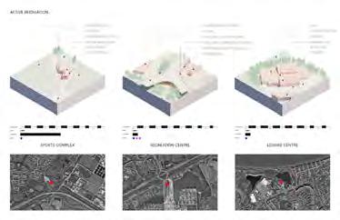
To help inform how to approach the new development that will extend Thamesmead it is useful to study how other planned towns have grown – either by design or organically. Each student was responsible for one case study. Students studied the growth of a town, or suburb, that was based on a distinct visionary urban planning concept. Some of these predate Thamesmead, while others are contemporaneous with it. In each instance they have had to content either with the adjacent city encroaching or urban growth emanating from their original boundaries.
How should a town grow?
The case study focused on qualities common to Thamesmead. The studies encompassed not only the physical changes that occurred over time but also whether and how the resident population was affected. It was important to ascertain a timeline of change. Lessons – both positive and negative – were drawn out as they might apply to the Thamesmead Waterfront. 30
Eun Soo Choi (MLA ‘22) / Natasha Harkison MLAUD ‘22) Letchworth, Hertfordshire, UK (1903)
StudiesCase

ZhuSovorGuo,ShannonSoygenis,Erin

Hampstead Garden Suburb, London, UK (1906)
Eun Soo Choi (MLA ‘22) / Natasha Harkison MLAUD ‘22)
StudiesCase

HarkisonNatashaChoi,SooEun

Erin Soygenis (MAUD ‘22), Shannon Guo (MAUD ‘22), Sovor Zhu ((MLA ‘22) StudiesCase 35 Cergy-Pontoise, Île-de-France, France (1972)
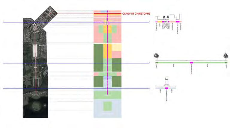

ZhuSovorGuo,ShannonSoygenis,Erin
36

Erin Soygenis (MAUD ‘22), Shannon Guo (MAUD ‘22), Sovor Zhu ((MLA ‘22) StudiesCase 37 Reston, Virginia, USA (1962) + Levittown, Pennsylvania, USA (1947)


ZhuSovorGuo,ShannonSoygenis,Erin

38

EngagementCommunity Process 39
Salliann Heaton, Resident 1976-88
“Growing up on Thamesmead was some good some bad. School was bad….At night we would go under the tower blocks and have a cig and some cider and play in the paddling pools; it was really nice – the only thing I didn’t like was school.”
In order to give students the opportunity to connect with local people, the studio engaged with a local secondary school through an online workshop. St Pauls Academy is located within Thamesmead, very close to the Thamesmead Waterfront site. Students designed the workshop. It was important to emphasize and convey that this interactive session was for the secondary school students, and it was meant to inform studio propositions. The workshop format facilitated a process where the secondary school students could express their critical thoughts about their neighbourhood and their aspirations for the future. 40
The first exercise in the community engagement process encouraged students to familiarize their audience with their day to day experiences. Each student was asked to draw a map of their daily walk to school, the park, the grocery store, or their local hangout. Students were separated into groups, and exchanged their map with one another. Then, in the larger group ‘zoom room’, each group chose a leader to recite the overall takeaways. As a studio, many lessons were learned based on safety, local neighborhood knowledge, students’ livelihoods, and experienced as they are known within the community. These were highly valuable moments to learn about, and the students expressed gratitude for being able to share with us.
ProcessEngagementCommunity 41 Exercise 01: Map Your Day


42


ProcessEngagementCommunity In exercise two, the goal was to gain insights on students’ preferences for community revitalization. Through a series of photographs and themes, students used ‘dots’ to place them on their favorite images. Further into the studio design process, these recollections were used to provide sufficient, useful, and necessary types of programming and design options to facilitate best uses for studio projects.

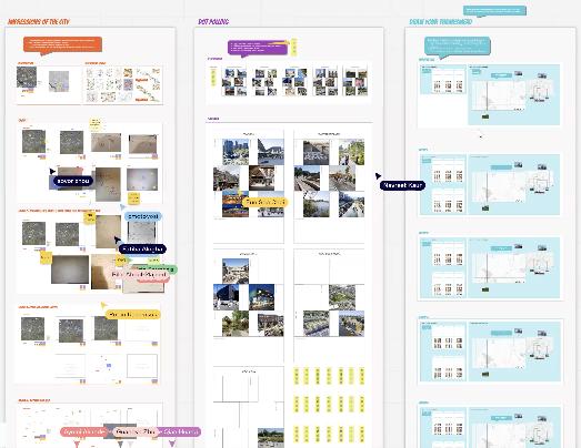
Exercise 02: Dot Polling
43
44

ProcessEngagementCommunity


The third exercise asked students to engage in an interactive planning game, where a Thamesmead site map (with neighborhood context) was provided along with a series of stickers with various types of program and engagement ideas. The results of the game found the students highly engaged in the workshop content. Students were asked to provided lessons learned, which allowed them to provide critical pros and cons of the Thamesmead as they understand it.
45
Exercise 03: Draw your Thamesmead
46


Studio Projects 47
Subsequently each student explored specific geographic and/ or thematic aspects of the framework. This allowed them to propose both strategic and detailed schemes that also looked at diverse solutions and how they might be implemented over time. 48
Drawing on the research, site analysis and learnings from various stakeholders, the students identified what they saw as the most critical issues that the masterplan framework for Thamesmead Waterfront should address. Working in small groups initially, students proposed framework plans that addressed issues related to physical and social mobility, transport infrastructure, community infrastructure, climate mitigation, environmental systems, the provision of usable opens space, vertical and horizontal use mix, the role of heritage, density and intensity, and how best to connect to and complement the existing Thamesmead neighbourhoods.
Eun Soo Choi(MLA, 2022), Xiangning Guo(MAUD, 2022), Oliver Shi(MLA, 2022) The Thamesmead Islands:
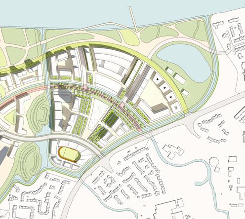
There will be 4 main ways of navigating the spacewhich are walking, biking, taking the tram, using the canals. Cars only serve a small portion of the islands, for emergency purposes. The Spine is the bike-andpedestrian-only path that connects the main cultural events. The promenade also has pedestrian and bike paths, but it also has the tram tracks extending out of the Waterfront and into Thamesmead, and the green tracks also serve as a rain garden.The green and the blue networks of the Thamesmead Islands go hand in hand to increase the effectiveness of flood mitigation.
This semester, we began with a wider look at Thamesmead, which has a high unemployment rate compared to the wider London, and a relatively younger population with nearly 60 percent of the population below 34 years old. While this neighborhood is known as a place for younger families, the youth often lack access to activities, due to two main factors: first, there is no sufficient public transportation, second, there are not that many things to do. Moreover, Thamesmead is disconnected from central London in terms of transportation, culture, retail, as well as healthcare. Flood management is essential in Thamesmead since most of the land is below the water level of the Thames river. It causes the waterfront to become a flood barrier, preventing people at the waterfront from physically or even visually engaging the Thames River.
How can we address the issues of disconnectedness as a unique characteristic of the site instead of a problem that needs to be solved? How can we achieve something that is both active and calm, urban and suburban at the same time? That’s when we arrived at the concept of an island, a landform that can reverse the idea of isolation and turn it into an Theattraction.islandas a spatial concept has been explored in literature throughout history. Shakespeare’s the Tempest explores how the Enchanted Islands can be experienced differently according to the characters No man is an island in and of itself, says John Donne, and every island should function as a piece of the continent, a part of the city. And visiting an island means to escape from the world of highways into the beautiful landscape. From the literary experiences, we composed three main spatial concepts. First, mobility mode as characters, the Thamesmead Island will provide multiple speeds of transportation. Second, the facilities essential for a community will be providedAnd third, the landscape will provide ecological services. Conceptually, Healing, Living, Trading are the main functions of the three islands that support the history and creative industries within the 15-minute radius of mobility, with access to essential facilities for self-sustainable community and ecological services that enrich and protect the living. We develop many strategies, including naming the three islands: Prospero, Miranda, and Ariel; pulling back the water edge, reducing the size of the artificial lakes to increase land area, compensating that by increasing water paths to drain rainwater into the Thames, integrating the new water network with the existing infrastructure, and providing major activities within 15-minute walking distance. So turning the site into islands is not just a conceptual exercise, but it is an infrastructural strategy to mitigate flood.
IslandsThamesmeadThe Isolation as Attraction
ShiOliverGuo,XiangningChoi,SooEun CirculationAxon systems RoadPlazaPromenadePedestrianSpineLegend 4 4 - Trams & Pedestrian & Bikes5 - Trams & Pedestrian & Bikes 6 - Trams & Pedestrian & Bikes 5 33 - Pedestrian & Bikes 1 2 1 - Road 2 - Water taxi 6


IslandsThamesmeadThe Island of Trading: Prospero Island of Living: Miranda Island of Healing: Ariel BuildingLEGENDUsesCivicBuilding(Library/Museum)Retail+RestaurantCommunityFacilitiesOffice/BusinessSchools/EducationHotelSportsFacilitiesResidential(Sell)TransportationInfrastructureApartment(Rent)


PHASE III(12 - 20 Y) FAR:1.4(with landfill). LAND AREA:272,472 SQM GFA: 392,969 SQM STATIONDLR ISLANDHEALINGOF PHASE (4-6ISLANDY)TRADINGOF REMEDIATIONLANDFILL FAR:3.28 LAND AREA: 108,553 SQM GFA: 355,325 SQM Master PhasingPlan ShiOliverGuo,XiangningChoi,SooEun PHASE II (6-12 Y) ISLANDLIVINGOF FAR:2.48 LAND AREA: 102,960 SQM GFA: 253,757 SQM WATERROADSPINEPROMANADEPLAZA/PAVINGBACKGROUNDLAWNORNAMENTALSHRUB/NATURALSTREETLEGENDTREETREETREE


Eun Soo Choi MLA 1 AP, 2022 53 Island of Healing: Biomedical Campus
An interwoven landscape experience

Scenic Viewpoint Move & Elevate Engage Add Commercial Use Connect Historical Artifact Wetland Canal Residential Residential Residential Woodland Spiral Hill Landfill Connect
The woodland at the edge of the site presents two residential communities turning their backs to each other. By turning the unprogrammed and unused woodland into a residential area that stitches them together. Enhancing the existing wetlands for biodiversity and involving the water paths to be at the center of the architecture combined with the slowness of the boats, would present a different urban experience that both the visitors and the locals can enjoy.
Ariel’s original landscape includes various features. While some were valuable and presented opportunities to enhance the experience, some were problematic. For example, the large landfill that rises about 15 meters from the Thames river contains contaminated soil. Hence, capping the landfill even more with the dredged soil from constructing the islands could enhance the viewing experience over the Thames river. The spiral hill is a problematic piece of landform that blocks any flow between the new development within the site and the adjacent residential community. Therefore, it would be wise to lower that landform to form a commercial plaza and recreate the spiral path on top of the taller landfill.

Ariel, the island of Healing is located on the West side of the three Thamesemead Islands and hosts the Biomedical Campus. The Campus provides spaces for the biotechnology industry, hospital, medical school, and student housing.

55CampusBiomedicalHealing:ofIsland

Wolfson Economics Prize 2021 Guidelines for Planning and Designing the Hospital of the Future


The
new hospital at the Thamesmead Islands will provide the hospital of the future, interwoven with the neighborhood, beautiful place that support the local needs, offering various garden spaces, that feels enclosed and secure. This addition of a hospital in the Biomedical Campus will serve the East London area south of the Thames river. HOSPITALS SHOULD BE: 1. Interwoven with neighborhood 2. Beautiful places to be proud of 3. Variety with a pattern 4. Naturally lit and ventillated spaces 5. Enclosed and secure 6. Green with garden 7. Adaptable and resilient
Therelationship.roofscape
ChoiSooEun56
of the Campus acts as an extension of the existing landscape: producing food to be traded at the market plaza, catching stormwater to delay runoff, providing gardens for the patients in the hospital 29,312 sqm 3,136 sqm 7,214 22,29072,26150,4954,54125,551sqmsqmsqmsqmsqmsqm by patients and medical personnel Accessible by students and workers


The sculpture park works with the Creative Distraict to support the local artists, and the curation will be managed by a committee formed by the local residents to help the newcomers and the locals form a productive
LEGEND Plaza & SportsSculptureMarketPark&Playing Fields RetentionWetlands Ponds

366 units 40 units 90 166unitsbeds LEGEND Agricultural Production Stormwater Retention Gardens - Accessible
buildings.ResidentialStudentHousingMixedResidential*CommercialCultural/HistoricalMedicalFacilitiesR&DOffices&LabsEducationFacilities Building Use LEGEND RoofscapeLandscape
The Campus offers vareity of building uses to support a campus life as well as the adjacent residential neighborhood that lack any commercial activities.
Gardens -


Architecture frames the landscape
CampusBiomedicalHealing:ofIsland

ChoiSooEun


CampusBiomedicalHealing:ofIsland Roofscape as an extension of the landscape

ChoiSooEun

CampusBiomedicalHealing:ofIsland Roofscape mitigates flood, provides outdoor space, and produces food...

ChoiSooEunIntegrating the natural landscape and architecture to support the living

Island of Living: is everything advantageous to life
Oliver Shi (MLA, 2022)
Under the master plan framework, Miranda is the island of living that provide the majority of housing for Thamesmead three islands. While living is the primary use of the island, Miranda also has creative industries, shared office space, public library, hotel, local business and resturants. Along Thames river, the waterfront park serves as a regional community park that have baseball field, children playground, gathering lawn, waterfront plaza and sailing dock. Three district are connected by different chaarac teristic parkways. The Promenade in the north has tram track and bike trails that connects the regional community. The spine is for biking and walking that connects three islands, where a 5m wide canal runs parallel to it. The centural parkway is emergency and delivery vehicle only. Private vehicles can access the island through a connector road that connects three islands to the arterial road. Within miranda island, a market alleyway and an art cursh walk bring people from south to the waterfront. As for community and housing, sports facilities, community gardens, and shared office space are pro vided across the neighborhood. The shared riverfront public spaces extend the natural experience into the courtyard.

Here
livingofIsland
Landscape & Public spaces
Riverfront
As for blue&green system, there are 10-m wide waterway that separates threee island and the 5-m wide waterway runs though them. NaturalWaterbodybank

HirtoricGatheringtump lawnPlaygroundCommunityBaseball Waterfront plaza
Circulation & Hardscape
GreengardenCommunityLawnPlazasarea Botanic garden CommunityCommunityplazagardeneventlawn
TownhousePublicroof garden
Diagrams describing programs, circulations and networks. With shared office/community space located in the lower level, where is vulnerable of flooding, residents are able to work remotely near their home. Retails are distributed along three main traffic routes. There are three districts with different characters, creative district, creek north district and creek south district. There are also three different transportation modes connect the island to the other two.
Waterway & Elevation Road bridgePedestian bridge Thames river(4m elevation)Sailing DockPump station Pump station 10-m wide creek (0m elevation) 5-m wide creek (0m elevation) 5m Ground level
Parkway/AlleywayHardscapeRoadSpinePromenade(Tram)Road Promenade(tram, walk, bike) Parkway(walk, emergency,delivery vehicle) Market Spine(walk,Alleywaybike, scooter) Art Crush walk ShiOliver
Creative District Creek south District Creek north District Waterfront park Creek south district Creative districtCreek north district
Island of living provides community scale spaces in the residential areas and large open space at the waterfront that serves regional community.
SharedHotelCultureRetail&ResturantOffice/Community Space Roof ApartmentGardenfor rent Townhouse for sell Apartment for sell Share spacecommunityoffice/
Figure Ground & Districts


soccer Tennis and basketball Building Uses


Public Library/ town center apartmentHigh-rise Mid-rise apartment Low-rise apartment Art gallery/workshop
Beer garden 7-player youth
livingofIsland

12th floor as rental apartments Hotel and Office spaceApartementsforsell

Creek reveals the identity and history of Thamesmead Public roof garden that provides views of Thames river 1st floor as retail and restuarant, 2nd to 4th floor as shared working space or community space
inland(5m)waterfront(8-10m)and5thto
Tram reflects the history of royal arsenal train transportation Creative district is adjacent to island of trading, prospero, which takes this advantage to become a middle ground between living and working. Art gallery, town center, public library, resturant, and shared work space are the major building uses here. Outside of the public library/town center, a botanic garden surves as a community gathering place. In the south, a beer garden space is surrounded by art galleries, local resturants and breweries. Public rooftop provides a view of Thames which is not accessible from ground level due to the raised waterfront elevation.
Terraced promenade closing the elevation difference between
Waterfront park as infrastructurerecreationalprotective
View of the promenade and creative district. Facade credit to Yu Qin.


Creek connects three islands and the rest of Thamesmead Trail brings people to the riverside Public library as a transition point fron creative district to residential area

Along the spine, retail and resturant are on the 1st floor, with residential on top Towards the Thames, buildings start to get higher as land value increases
ShiOliver


View of spine and creek north district on the left. Facade credit to Yu Qin.

Pedestian bridge that brings neighborhoodtwoas a whole. Creek north district is between landfill and cre ative district. High-rise apartment are located along the promenade to take advantage of Thames river. Apartments and town houses are mixed to form series of public space which provides comunity garden, waterfront plaza and playground to the Theresidents.market alleyway is space for community veg etable market, where residents can sell their food growed in the garden. A sailing dock, playground and baseball field serves as the community water front in the north.
Spine connects three islands by scooters, bikes and walking.
View of riverfront housing of creek south dirtrict. Facade credit to Yu Qin.

Gradual

3rd to facingtownhouses4thwest
4th to 6th floor low-rise apartment facing south riverfront trail connects different neighborhoods Riverfront plaza that become an outdoor amphitheather and play area change from hardscape to natural condition Yacht and sailing is one of activitiesThamesmeadBuilding-waterframedcourtyardspacewithsportsfacilities,playgroundsandcommunitygardens.
livingofIsland

Creek south district is mixed by apartments and town houses. Sports facilities provides activities space for 7-player youth soccer, tennis and basketball, which is accessble for resident from the island as well as resident from other Thamesmead neighborhood. Shared office space and retail space are also provided on the first floor due to the flooding risk and public character here. The historic tump structure are preserved as natural amenity. The market alleyway brings people from south to Thames waterfront. The connector road is accessible for private vehicles.

Circulation & Hardscape Figure ground & District Landscape & Public spaces Waterway & Natural bank Exploded Diagrams ShiOliver


TradingofIsland 69 Island of Trading:
Here is everything advantageous to life
The island of trading is the densest area which is located on the east of the site. The south of the island is connected with the original local residential com munity. The Thames River is on its north. On the west side, there is some connection with the living island. Therefore, the main problem is how to benefit both the new and existing Thamesmead residents, how to allow residents who walk or cycle from local commu nities and citizens who come from the central London by DLR to have better communications and outstand ing spatial experience.
The newly built DLR station is located right in the center of the site. Convenient transportation has given great value to this area, which can be used as a com mercial and office center for the Thamesmead. The railway platform will be directly connected to the cen tral plaza. The town center works as an urban anchor to attract people from the central London with the arriving DLR station. The density is relatively higher compared to the other 2 islands. From north to the south, the programming changes from economic cultural oriented districts, to educational district which mainly serves the surrounding neighborhood.
Xiangning Guo MAUD, 2022
The southern area connected to the local community consists of a primary school and an open stadium serving both the new and existing residents. Public space system is designed around the spine that runs through the entire Thamesmead. It is ben eficial to increase the density of people flow on the green axis to promote the encounter and communi cation between people and reduce crime rate in the Thamesmead.
The transportation system divides the entire site into 7 areas with different mixed-use programs. The area close to the Thames is mainly residentials, hotels and theater, which makes full use of the excellent waterfront resources. Areas on both sides of the central plaza are mainly composed of offices and commercials, serving people from the DLR station.
Current programs around the site is monotonous, and there is a lack of necessary commercial and cultural amenities for local community. The Thames Estuary Production Corridor is also a significant vision to unite east London. Therefore, relying on the new DLR sta tion, the project plans to provide a series of cultural facilities such as concert halls, galleries, and theaters to enrich local residents’ daily lives. Finally, the area will become a TOD center containing mixed uses like commercial, office, and cultural facilities, which would stimulate the whole Thamesmead area.
GuoXiangning70

TradingofIsland Axonometric View Xiangning Guo MAUD, 2022 Island of Trading: Here is everything advantageous to life

GuoXiangning

The island of trading is the densest area which is lo cated on the east of the site. The south of the island is connected with the original local residential com munity. On the west side, there is some connection with the living island. Therefore, the main problem is how to benefit both the new and existing Thame smead residents, how to allow residents who walk or cycle from local communities and citizens who come from the central London by DLR to have better communications and outstanding spatial experience. The current programs around the site is monoto nous, and there is a lack of necessary commercial and cultural amenities for local community. The Thames Estuary Production Corridor is also a signif icant vision to unite east London. Therefore, relying on the new DLR station, the project plans to provide a series of cultural facilities such as concert halls, galleries, and theaters to enrich local residents’ dai ly lives. Finally, the area will become a TOD center containing mixed uses like commercial, office, and cultural facilities, which would stimulate the whole Thamesmead area.


TradingofIsland
73
GuoXiangning74
Perspective seeing from the plaza in front of the concert hall

Perspective seeing from the 2nd floor of office buildings

Section A-A A A
The town center works as an urban anchor to attract people from the central London with the arriving DLR station. The density is relatively higher compared to the other 2 islands. From north to the south, the programming changes from economic cultural oriented districts, to educational district which mainly serves the surrounding neighborhood.
The newly built DLR station is located right in the center of the site. Convenient transportation has given great value to this area, which can be used as a commercial and office center for the Thamesmead. The railway platform will be directly connected to the central plaza.

The multi-layered DLR station is embedded underground with some connections with the office and cultural center. We could see the variation of the building heights.
TradingofIsland 75
GuoXiangning76


B B
The multi-layered DLR station is embedded underground with connections to the office and cultural center.

TradingofIsland 77
The building volume follows the following principles:
3. Although the building density in the core area is relatively high, I still hope to provide an experience of human scale when walking on the pedestrians. The receding terraces form a large number of platforms of different heights, creating diverse public spaces and 4.landscape.Finally,the height control of the entire area follows the strategy of gradually decreasing from the center to the outside, creating the identity of town center in the central area. B-B
2. On the north and south sides of the site, the build ing volume adopts different strategies. The building volume close to the local community will be smaller in response to the urban texture and block scale.
Section
1. The building close to the central plaza has the higher density, making full use of the transportation advantag es brought by DLR stations.
GuoXiangning78


Thamesmead waterfront is an area with beautiful land scape and marshland, a precious piece of ecosystem that is under huge development pressure from the housing crisis in London. The area remains undevel oped because of poor accessibility. Illustrated in the comparison diagram of transportation time between a satellite city of London and Thamesmead, the dis tance from Central London to Welwyn Garden city is twice to Thamesmead, while only use half of time to arrive there. Recently, municipality has an intention to extend DLR railway system to Thamesmead and that triggered the real estate company, Peabody, start to develop this area. An assumption received from Peabody suggests that a total of 15,000 new homes and 8,000 new jobs will be needed in order to justify the construction of a new DLR station landing at the center of the site. From the capacity fit out, I assume an average size of 70 sqm for each unit and provided parking according to the zoning rules. The outcome convinces me to challenge the number and to find another way to make the DLR project econom ically viable.
UrbanizationResources:ledbyRecycling
2. Current Situation
Introduction In this project, we prove trash is not something unwanted. Instead, they are valuable resources that happen to be misplaced on site. When treated wisely, waste can generate economic revenue, alle viate environmental stress from climate change and inspire a whole new lifestyle.
1. History Context
Between 1500s-1700s, Thamesmead comprised of wet marshlands, formerly known as Plumstead Marshes and Erith Marshes. The area was drained as early as the 1500s for use as farmland and for habitation. Around 1878, The site was used mainly for testing ammunition as the marshy land was good for absorbing the noise created through the explo sions. After 1920, Ammunition testing, production and storage of ordnance took place on the site until WWII. At its peak more than 70,000 people worked in the thriving military zone with its own railway and canal network. The Greater London Council created the new town of Thamesmead in 1966. The premise was ambitious: a new town for 60,000 residents as part of the GLC’s plans to ease the London hous ing crisis at the time. By the mid-1970s the scheme was marred with issues and the initial masterplan abandoned.
Misplaced Industries
ResourcesMisplaced Deqian Huang (March I, 2022) Zeqi Liu (MLA I, 2022) 79
3. Strategy We turn our eyes to waste both in liquid and solid form. Speaking of recycling water, we look at two water treatment plants near the site, Beckton to the North and Crossness to the East. They are the two biggest sewage plant in Europe, where treated efflu ent discharge into Thames River. The process of water treatment is to turn raw sewage into two prod ucts, a treated effluent, and semi solid residue known as sludge. They both contain high level of nitrogen and phosphorus which is one of the main pollutants in Thames river. Instead of throwing them back into the ecosystem, the two chemicals can be extracted and used as fertilizers. The treated effluent will supply non-portable water use in our community. Sludge will combine with food waste and go into biogas reactor that give us urban farm fertilizer and thermal supply. Then we look at solid waste. Our strategy is three part, first we want to reduce solid waste by using less disposables. Then we want to better separate differ ent type of waste by dispersing the sorting stations. Then, we will use ashes from incineration to reclaim the contaminated land demonstrated. Better local waste sorting increase recycle % and provide ash for land reclamation. We want light industries to inspire a new living experience by integrating them with public amenities. Such amenities will be distributed along several spines in the site.
HuangDeqian LiuZeqi80 1. BIOGAS REACTOR 2. LOCAL WASTE SORTING 3. URBAN FARM FERTILIZER 4. LOCAL ELECTRICITY GRID 5. THERMAL SYSTEM 6. WETLAND WATER SYSTEM 7. SOIL RESEARCH INSTITUTE 8. HIGHER EDUCATION 557 JOBS 354 JOBS 335 JOBS 247 JOBS 179 JOBS 676 JOBS 157 JOBS 217 JOBS Treated EffluentSemi solid residue - Sludge Local Waste SortingSewage Treatment Food WasteIncinerationRecycle Biogas Reactor Supply nonportable water use UrbanFertilizerFarm ThermalSupply Local ElectricityLand Reclamation
Twotunnel.water
jobs,

treatment: Beckton to the North and Crossness to the East, where treated effluent discharge into Thames River.

and land scape
from climate change is that we will receive heavier rain in winter and less water in summer. Our framework also focuses on moderating the water supply and demand by looking at ways to preserve and recycle water.
Levels of Waster Stress N/ALowModerateSerious
By taking a reference from a survey done in Italy, we predict such proposal will provide additional 2700 promoting a growth in renewable energy Treated effluent and sludge can be transported along with the DLR

industry.
The red region highlights the flooding risk across the Greater London. Nearly half of the site is under flooding risk and this line in the middle is a guideline we use in our framework to place different building


Anothertypologies.consequence

For the blue network, we have two zones. Zone 1 is sponge community and zone 2 is restored wetland system.


We design a 3-tier layout that covers the whole site with no overpass. Therefore our street sections incorporate landscape trails for pedestrian and biking use.
We also enhance the experience by raising the ground at the waterfront, allowing it to function both as a protective flooding wall and an immersive landscape.
For green corridor, we have five guidelines each with a central theme: starting from the left is centered around solid waste, where recycle plants serve as main anchors.
WasteSolidA AcademicBInstitutionDLRStation CultureC CommunityD WasteLiquidE Zone 1 Sponge Community Zone 2 Biological Filter
ResourcesMisplaced
HuangDeqian LiuZeqi
Here is our site plan of the whole framework and where we choose to zoom in to develop further.

83ResourcesMisplaced First is the DLR station. Our site takes in 3% of treated effluent and sludge from the plant, using the same tunnel as DLR under the river.
We proposed an underground DLR station because we looked at various sections through an existing railway, in which the tracks become a separator of Thecommunities.newstation
Thereforeedges.
we restore wetland that adapts to climate change and hardscape design such skateboard parks that store water. It is a sustainable landscape plaza that serves ecological functions. Then, it is the museum. The historical relics used to store nitrogen explosives in the Mirroringpast.that in contemporary times, we proposed a vertical farm where it takes nitrogen fertilizer from DLR station and purified water from adjacent Heremarshland.isasection perspective showing the integration of contemporary urban farming and local history, where visitors can meander through the relics, watch documentaries, and enjoy locally grown foods.
After understanding the local needs, we are confident that we can build a place where residents can feel relaxed and comfortable, fostering a sense of belonging and pride to be part of the neighborhood.
Thus, we propose the cultural corridor that will house programs such as podium seating for small concert, biking racks that promote sustainable commuting and cafes for gatherings.
gently follows the existing topography, allowing free movement at ground level. It not only bridges neighborhood on both sides, but also bringing commuters closer to nature. An ecowell that opens to the sky, collecting rainwater. A library that supports waste research. Earlier vision of public plaza demands a level of maintenance that is unsustainable for the neighborhood such as water fountain. As a result, people have turned their backs towards those water
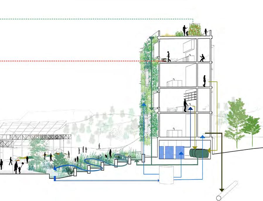
Moving toward residential section. We compliment the sludge network with water and plastic recycle network. Each parcel of land is interconnected and mutually dependent to create a strong resilient community. The section perspective illustrates three systems. Grey water is biologically purified through stepping terrace, contribute to non potable use. Small scale neighborhood farm supply weekend market with locally grown food, reducing carbon footprint and waste from packaging. Solid waste gets better sorted and recycled at various stations. And we have workshops on the second level to turn plastic trash into art installations. Those art pieces will be scattered on the eco corridor, which provides an immersive landscape for potential art Fromfestivals.ourcommunity workshop with local high school students, we take insights from their daily lives. For instance, they enjoy walking down into the woods. They seek an alternative weekend plan other than going to a crowded mall. They long for a place to hangout with friends besides grocery stores.
84 HuangDeqian LiuZeqi
we are confident that we can build a place where residents can feel relaxed and comfortable, fostering a sense of belonging and pride to be part of the neighborhood.

ResourcesMisplaced Zoom-in site plan

HuangDeqian LiuZeqi

The new station gently follows the existing topography, allowing free movement at ground level.


87
DLR station
We proposed an underground DLR station because we looked at various sections through an existing railway, in which the tracks become a separator of Thecommunities.newstation gently follows the existing topogra phy, allowing free movement at ground level. It not only bridges neighborhood on both sides, but also bringing commuters closer to nature. An eco-well that opens to the sky, collecting rainwater. A library that supports waste research. under the river.
Earlier vision of public plaza demands a level of maintenance that is unsustainable for the neighborhood such as water fountain. As a result, people have turned their backs towards those water edges. Therefore we restore wetland that adapts to climate change and hardscape design such skateboard parks that store water. It is a sustainable landscape plaza that serves ecological functions.

88 HuangDeqian LiuZeqi

Here is a section perspective showing the integration of contemporary urban farming and local history, where visitors can meander through the relics, watch documentaries, and enjoy locally grown foods. Existing Condition 1st stage before 1890 Nitrogen Storage 2nd stage 1890 Testing explosive and canal at sand dune 3rd stage 1914


Museum The historical relics used to store nitrogen explo sives in the past. Around 1878, The site was used mainly for testing ammunition as the marshy land was good for absorbing the noise created through the Mirroringexplosions.thatin contemporary times, we proposed a vertical farm where it takes nitrogen fertilizer from DLR station and purified water from adjacent marsh land. The museum is an integration of contemporary urban farming and local history, where visitors can meander through the relics, watch documentaries, and enjoy locally grown foods.


HuangDeqian LiuZeqi90

91
Residential Section
We compliment the sludge network with water and plastic recycle network. Each parcel of land is interconnected and mutually dependent to create a strong resilient community. The section perspective illustrates three systems. Grey water is biologically purified through stepping terrace, contribute to non potable use. Small scale neighborhood farm supply weekend market with locally grown food, reducing carbon footprint and waste from packaging. Solid waste gets better sorted and recycled at various stations. And we have workshops on the second level to turn plastic trash into art installations. Those art pieces will be scattered on the eco corridor, which provides an immersive landscape for potential art festivals.
The section perspective illustrates three systems.


HuangDeqian LiuZeqi
Thus, we propose the cultural corridor that will house programs such as podium seating for small concert, biking racks that promote sustainable commuting and cafes for gatherings. After understanding the local needs, we are confident that we can build a place where residents can feel relaxed and comfortable, fostering a sense of belonging and pride to be part of the neighborhood.
92
From our community workshop with local high school students, we take insights from their daily lives. For instance, they enjoy walking down into the woods. They seek an alternative weekend plan other than going to a crowded mall. They long for a place to hangout with friends besides grocery stores.
Composition of residential section


As a team of urban and landscape designers, we identified a few design solutions to address exist ing issues within the community. Firstly, it is difficult for local residents to access the waterfront areas because of limited access entry and existing barri ers. The edge type of waterfront areas varies but is generally quite hard as shown in the section draw ings. Secondly, even though parks and open spaces spread commonly in the community, the inadequate site access and barrier exacerbate the accessibility to those spaces. Thirdly, there are limited commu nities amenities that discourage future residents to move into the region. Our proposed design solu tions are specifically tailored to the three problems mentioned above. As a result, we intend to imagine new street typologies and create more efficient multimodal transport systems to make the communities more connected and accessible. Additionally, we aim to design more recreational spaces and new park systems to accommodate the growing popula tion. Moreover, we mean to integrate more mix-used development to support the economic growth in the neighborhood. The detailed design strategies are explained below.
Austin Lu, Julia Zhu, Sovor Zhu
On a site scale, we proposed trails throughout all the blocks to increase the walkability of the city. By taking the trails people could access their destinations in a shorter distance and a better walking experience.
Second, we proposed three kinds of green spaces to the city: Waterfront parks, art parks and urban multi function parks. The waterfront parks are communal recreational spaces that are intentionally designed to deal with floods with landscape berm and pro vide people a better experience to get closer to the wetland ecosystem. Art parks are adjacent to the art district that provides a tour to outdoor galleries and art performing. Urban multifunction parks are pub lic spaces that can hold gatherings, meetups, and hangouts for recreation and fitness, encouraging community interactions.
Thirdly, we aim to revitalize the neighborhood by promoting integrated mixed-use development. The strategy starts from DLR station. The roads connected DLR with other areas enjoy the most pedestrian flow, so strip stores and other commercial clusters, public buildings and hotels are planned to be built around, which activates open space around them.Those acti vated spaces further vitalize their surrounding open space. The program in open spaces is defined by the surrounding edges. For example, vendor exhibition are set between historical buildings and museums. Commercial uses around here would be art stores, sonvenior stores and restaurants. Other three types of open space are also designed in the similar way. Strips stores are only set for the first floor. Residential blocks are planned near commercial used buildings so that residents can easily access to the commercial area.All of the residential blocks, as well as the exist ing residential area surrounding the site, are next to the green space.The rest of those buildings are public used, office or art studio. As a result, we could see both vertical and horizontal diversity and how differ ent pedestrian flows inside those open spaces give buildings the appropriate functions. 93
First, we connect Thamesmead in three different scales. On a regional scale, we connect Thamesmead with greater London through the proposed DLR and docs that locate on the waterfront. Which could easily introduce people from the other side of Thames to the site. On a city scale, we connect Thamesmead water front with lower Thamesmead by extending the major roads and propose some walking friendly and bus friendly secondary roads to create a circulation network. This designed circulation network encourages public transportation’s uses by setting “5-minutes walking bus stations” to make sure people could take the bus to anywhere they want on the site. On the side, the proposed roads we designed shortened the drive lanes and widened the sidewalks and there will be bike lanes and planting areas in each direction.
Thamesmead Districts
DistrictsThamesmead
ZhuSovorZhu,JuliaLu,Austin94


DistrictsThamesmead 95


96
ZhuSovorZhu,JuliaLu,Austin


Cultural Legacy Thamesmead Art District Austin Lu MLA II, 2022 Chapter 1 A Home

Cultural Legacy:
Scene during Art Festival
A Home
DistrictArtThamesmead for for
LuAustinThamesmead Art District

Thamesmead is branded as a cultural hub based on the cultural infrastructure plan released by Peabody Group. The report focused on delivering a cultural center at Thamesmead waterfront, developing large-scale creative production workspaces, and exploring work and live spaces for creative companies and professionals. The art district is a great medium to attract tourists, boost local economies, and a great way to preserve the culture. Inspired by the cultural infrastructure plan, this project aims to create the art district at the center of the community, the key cultural and educational center, surrounded by mixed-use residential blocks.
The art district offers recreational amenities for the community and better serves the residents and outside visitors. The art district is the new brand for Thamesmead as a cultural and educational center. 99

Goals + Opportunities Site Master Plan

Austin Lu MLA II, 2022
DistrictArtThamesmead
The outdoor spaces serve multi-purposes including recreational, cultural, and educational destinations. To improve the accessibility within the community, four levels of road systems are planned: primary roads, secondary roads, primary trails, and secondary trails. Many cultural features such as theater, outdoor exhibition, sculpture garden, art wall, pop-up stores, art dining, and film studio are designed for diverse types of activity. Additionally, education is also another key component of the art district. Students can visit the museum, student center, performance pavilion, and outdoor classroom anytime.
4
Concept Generation Process Mobility Options LuAustin5 100


6 Austin Lu MLA II, 2022 101


DistrictArtThamesmead
Primary Road Section Secondary Road Section Cultural Features

Cultural OutdoorSculptureFeaturesGardenPerformance Outdoor Exhibition LuAustin7 102


Outdoor
DistrictArtThamesmead

EducationalClassroomFeatures
8 Austin Lu MLA II, 2022 103

Drainage + Landscape Diagram Delivery Diagram Building Entrance + Park Access Diagram LuAustin9 104


Art District Aerial View
DistrictArtThamesmead
10 Austin Lu MLA II, 2022 105

LuAustin11 106

107
Radburn where there is a separated road system for vehicles and pedestrians, Pedestrian paths are mainly penetrated through parks. The shortage here is the safety issue due to the lack of pedestrians at night. So for my studies, I am seeking to create pedestrian paths in the park while trying to attract the most pedestrian flow. I firstly want to connect the three blocks by break ing the buildings. But in this way, all the open space is becoming public space . Residents here cannot find a semi-public space for them to gather and rest. Then, large Courtyards are formed in sacrifice of enough connectivity. However, with such a large scale of courtyard, it’s doubtful that a certain amount of privacy is provided. Finally, the strategy is having different linear parks connecting different communi ties and providing shortcuts for pedestrians, keeping the right scale of different courtyard.
Two linear parks provide ways for residents to commute and go home. Learning from the case study, we are supposed to provide enough pedestrian flow for those linear parks.In doing so, all the linear parks are connecting the facilities with much pedestrian flows and the natural area. Providing shortcuts for pedes trians. So there will be enough pedestrians in those parks.Then, diverse programs and edges along those linear parks are another way to attract pedestrians. A mixed and walkable community is built in this way. Vertically, the edges facing the main street, which connect DLR and waterfront, are retail spaces on the first floor. Horizontally art studios are penetrated from the art district to the residential area. So there are some art studios on the first floor and the footprint is designed for that use. Linear parks are designed to become more and more larger when they reach the waterfront area. This is to try to make sure that pedestrians could directly see the water from the starting point, so that they will be attracted to the park. Another advantage of it is that residents on that edge can also see the river from the balcony because of the shape. Connected to the linear park are common courtyards , which provide semi public space for residents. I tried to study different kinds of openings and how they form different kinds of privacy in the courtyard. Besides, because of the truth that public buildings and art studios have larger footprints than residential buildings. Roof gardens are formed when residential buildings are above.Shared Garden is provided for the artists working in art studios, and private gardens are assigned for different family units.
BlocksResidentialThamesmead
Thamesmead Residential Blocks
Guangya Zhu (MLAUD)
The location of my focused site, sitting next to the art district and dominated by residential blocks. The mis sion here is trying to create a connected and mixed community. I tried to borrow from my Case studies
ZhuGuangya108 Case Study: Radburn’s Walking System Strategy Development Process


BlocksResidentialThamesmead 109 Thamesmead Residential Blocks: Open Space System, Mixed-use Buildings and Pedestrian Flow

ZhuGuangya110

BlocksResidentialThamesmead 111 Linear Park System Linear Parks System

Another advantage of it is that residents on that edge can also see the river from the balcony because of the shape. Linear parks are designed to become more and more larger when they reach the waterfront area. This is to try to make sure that pedestrians could directly see the water from the start ing point, so that they will be attracted to the park.

ZhuGuangya112

BlocksResidentialThamesmead 113
Courtyards and Roof Gardens System

Because of the pedestrian flow and safety in the linear park , the front doors of those buildings are arranged along those streets or linear park.

If a courtyard has only one opening, non-res idents will not come in. If the courtyard has two openings where they are not facing each other, it will also block non-residents. By con trast, if the openings are facing each other, it will be regarded as a shortcut, welcoming both residents and non-residents.Another ele ment that forms the level of privacy of open space is the height of opening. So I assign some openings that are only on the first floor to let residents walk through different court yards without increasing the level of publicity of those courtyards.


ZhuGuangya114

thamesmeadchapter-theSovorZhou|Kathryn

chapter 3 the future city Zhou | Kathryn Firth
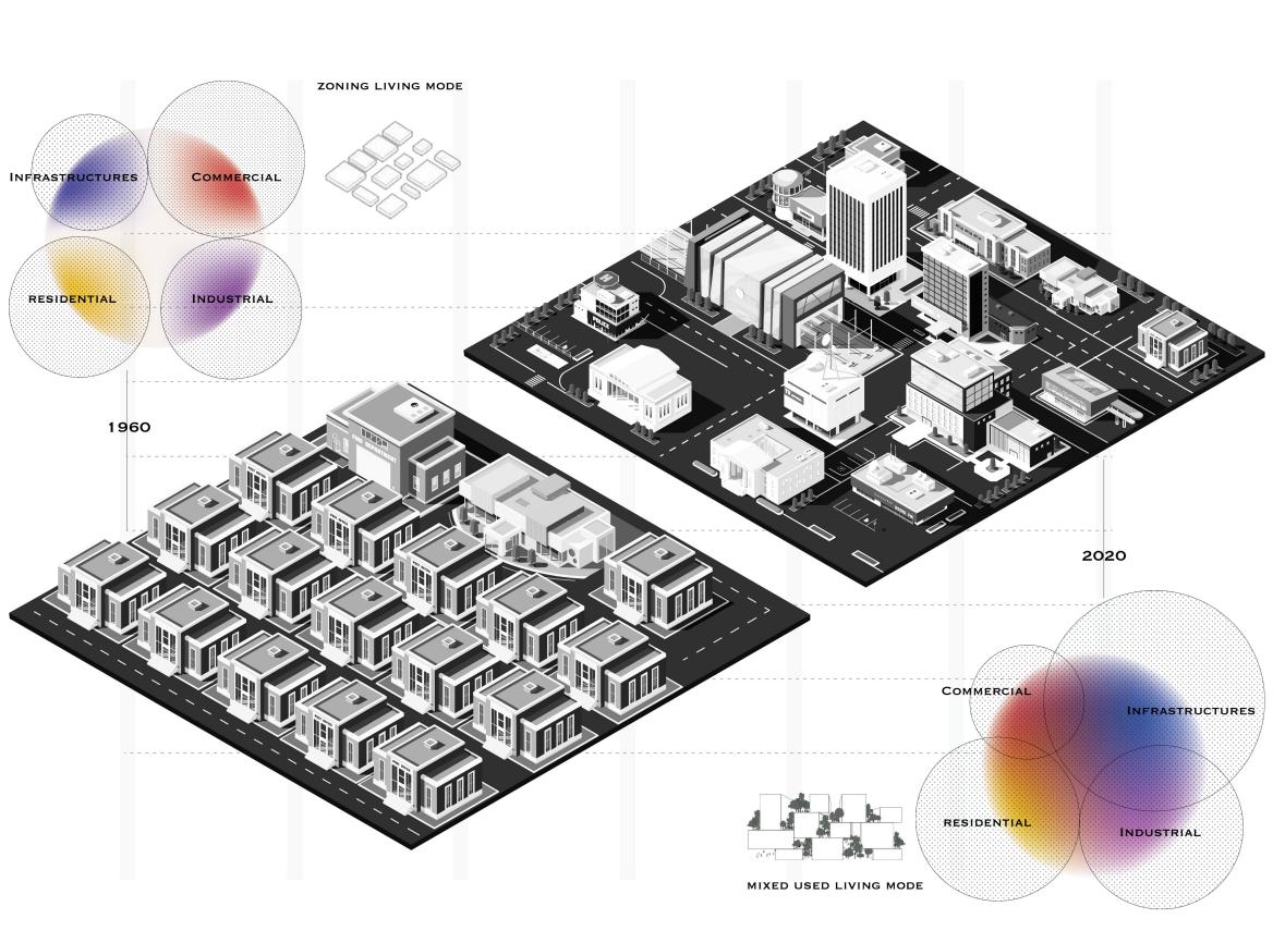
Thamesmead entered this world in the late 1960s, when Thamesmead was conceived as a town of the future. The developers and designers billed it as a futuristic utopia for southeast London. However, that did not happen. A city is a place where people can spend their entire residential career, from childhood through to old age (moving out of the family home, setting up home as a couple, establishing a home for one’s own family, growing old), and perform most of their day-to-day activities (work, shopping, socializ ing, leisure). We tried to make Thamesmead qualify as a successful city in previous masterplan, however we what about the future part? To predict what will happen in future, I study the past, the 1960s when Thamesmead appeared and compare the past with today 2020 in 6 lenses: carbon emission, outdoor time spending, natural resources overview, aging population, household size and mixed used lifestyle. By studying the trends, we can predict what will happen in the foreseeing future and those predictions could lead us the design strategies like low carbon transportation systems, attractive outdoor spaces, private green spaces, and small group shared living mode. Then, the design strategies will lead us the specific design guidelines which finally arrive at the new masterplan.
The future city

Sovor Zhou MLAII, 2020
Thamesmead revitalization
cityfutureThe-Thamesmead 117
ZhouSovor118 Carbon emissions from 1960 to 2020 Outdoor time spending from 1960 to 2020


cityfutureThe-Thamesmead 119 Thamesmead revitalization Natural resources overview from 1960 to 2020 Aging population from 1960 to 2020


ZhouSovor120 Household size from 1960 to 2020 Mixed used lifestyle from 1960 to 2020

121 MASTER PLAN Open landscape perspective

cityfutureThe-Thamesmead

ZhouSovor122 Silvermere lake view Town center view Thames river waterfront view


Living in ThamesmeadWater:Waterfront Community
WaterinLiving 123
ErinMAUD,Soygenis2023
Located along the Thames River, Thamesmead site is at the intersection of core wetlands and prime green areas, and with the extension of the new DLR line, will be easily accessible from London and other surrounding towns. However, the area is challenged by flood risk along the Thames. With the region getting more and more urbanized, the softscapes have been transformed into hardscapes over time, and forming a patchwork of green and blue. As a result, these disconnected permeable surfaces are not able to handle the flooding and rainfall that is increasing every year. Although the city has tried to address this challenge through various flood prevention infrastruc tures such as Thames Barrier, the region is still under the threat of Thamesmeadflooding.hadbeen
built on a marshland site ini tially with the vision of living in the green spaces and natural reserves with connectivity to the water. Due to the danger of flooding, the strategy was to lift up all the housing to the first level and link the places through elevated walkways, these were seen as very futuristic at that time. However, this vision became a threat as this elevated living left the streetscape unoccupied, disconnected, and unsafe. The Thamesmead site, located along the river is an opportunity to negotiate between the waterfront and the town, and to stitch together the disparate adja cencies through an ecological and social framework. In understanding the context, the project investigates the relationships with water, and explores three con cepts: Water and Resilience, Water and Economy, and Water and Community. The design incorporates water that streams through the site and generates a diverse array of green expe riences for the community from reserves to civic parks and wetlands which also serve a dual purpose for the industry. For a resilient waterfront, the issue of high tides and flooding is tackled through strategies such as breakwater, tidal pools dunes and storm water retention reservoirs. Preserving the areas that have ecological value, as well as retaining the structures that have collective memory value such as the town center determine and contain the buildable areas of the site. With the DLR extension arriving next to the existing town center, the development will attract peo ple from other towns for job opportunities in addition to local people.As a result, the area near the station is densified with more workspaces that relate to water research and development, water treatment, man agement and training. A woonerf/shared street lined with retail links the town center area to the waterfront and is anchored by community spaces such as a school along the way, that integrates water educa tion as part of a broader social resilience framework through creating awareness on coastal resilience and ecology. The waterfront area is, although intensely residential, includes co-working spaces, incubators and makerspaces relating to water technologies as well as community workshop spaces. Through adapting these strategies and enhancing access to the water’s edges, the aim is to create spaces for water to seep into everyday life in the form of recreation, research and production, and education and risk management. In blurring the edges between water and built areas, the aim is to create intertwined networks of resilience, economy and community to incorporate a lifestyle with water.
View along Corridor
SoygenisErin124
the Green

WaterinLiving

SoygenisErin Master Plan

WaterinLiving 127 Greater London Green and Blue Networks

To alleviate the pressures, the first strategy is to expand and connect the existing blue patches in Thamesmead area to integrate them into a larger ecological system and have them serve as potential water reservoirs.

CONNECTwaterfront.ECOLOGICAL
128
SoygenisErin
Through inserting community pavilions near important water bodies all around Thamesmead, the community is interlinked and integrated to the waterfront development through a pedestrian/bike trail in red, while the tram line in blue loop also extend access into the existing neighborhood from and to the DLR and NETWORK
In order to provide public access to the waterfront, and bring people into the site, the existing patches of green are extended as green links along the water streams. The marshlands are connected as a one permeable system allowing biodiversity to grow and sustain, and the waterfront is understood as a continuous public trajectory linking west-east of the site.

PROVIDE PUBLIC ACCESS TO THE LINKWATERFRONTTHECOMMUNITY

WaterinLiving 129 WATER RESTOREDTRAILEDGESTABILIZEDRUBBLEPAVILIONMOUNDWETLANDSDUNESBREAKWATER TIDAL WATERFRONTPOOL PARK TIDALTRAIL CONSTRUCTEDPOOL EDGE WATERCO-WORKINGGENERATIONTIDALAPARTMENTSENERGYSPACETECHNOLOGIES TRAILRESERVEECOLOGICALMOUNDNATURALEDGE FLOODABLEWORKSHOPSCOMMUNITYAPARTMENTSOPEN SPACE PROGRAMMED BARGE TRAIL


SoygenisErin130 MARINEWATERINDUSTRYRESEARCH WATER TREATMENT WATER EDUCATION FISHING TRAILGREENSTREAMMARKETSEAFOODCOVENURSERY/CORRIDOR WATER BASINPHYTOPLANKTONAERATIONMARSHLANDFACILITYTREATMENTZONEFLOATINGCLASSROOMRAINGARDENGREENCORRIDORSTREAMSCHOOLANDAPPRENTICESHIPWATERTOWNMEDIATHEQUEOFFICESWATERWOONERFRESEARCHCENTRETREATMENTTRAINING


WaterinLiving 131 PRIVATERETAILAPARTMENTSDECK GARDENPARKINGRETAILFLOODABLE OPENCOMMUNITYSPACE STREAMTERRACETERRACEAPARTMENTSSPACESGREENCORRIDORLOOK-OUTDECKTRAILTOWNHOUSESGREENHOUSETERRACEPRIVATECOMMUNITYGARDENS COURTYARD TYPE ONE WATERFRONT COVE TOWNHOUSE


SoygenisErin132 GARDENTERRACEPARKINGCULTURERETAILRESIWORKWATERINCUBATOR/MAKERSPACERETENTIONSTORMRETAILGARDENSUNKENAPARTMENTSPUBLICWATERRESERVOIRTECHLAKEMARSHLANDACTIVITYDECKTRAILCO-WORKINGSPACESAPARTMENTSPRIVATEGARDENTERRACE&COMMUNITYCOURTYARD TYPE TWO WATERFRONT BAR


WaterinLiving 133 URBAN AREA URBAN AREA ACTIVE RECSPORTSPARKPATH PATH LANEBIKECOMMUNITY GARDEN COMMUNITY GARDEN MARSHLAND MARSHLAND MARSHLAND SUNDKEN GARDENCOURTYARDTRAMSTREAMTOWNHOUSE TOWNHOUSESIDEWALK SIDEWALK SIDEWALK STOREFRONT SEATING APARTMENTSROAD ROAD ROAD BIOSWALE BIOSWALE PASSIVE RECREATIONRESIDENTIAL RESIDENTIAL BUFFER BUFFER ZONEAQUATIC BIOSWALE Section through Townhouse-Marshland-Courtyard


SoygenisErin134 URBAN AREA ACTIVE RECREATIONACTIVE RECREATION PATH PATH PRIVATE GARDEN SIDEWALKSIDEWALKSIDEWALK APARTMENTSAPARTMENTSFORESTLANDLOW FORESTLANDLOW FOREST ACTIVITY NODES STREAM PLANTSAQUATICPLANTSAQUATICDECKS PLAYGROUNDPLAYGROUND BIOSWALE PASSIVE RECREATION RESIDENTIAL RESIDENTIAL BUFFERBUFFER ZONE AQUATIC Section through Green Link-Waterfront Bar Typologies

WaterinLiving 135 View in the Fishing Cove

SoygenisErin136
View on the sports barge in the Waterfront Park

Map’ is a story about everyday affordability, spatial needs, and artistic endeavor. Located in the southeast area of London between Greenwich and Bexley, Thamesmead is home to a diverse ethnographic makeup. The ‘city in the east’ is poised for sustainable growth strategies at a time where young city dwellers continue to generate micro economies through cultural production throughout London. Thamesmead has a unique cultural heritage, having evolved over the last 50 years - especially as migration patterns have significantly shaped the region. With its iconic Brutalist architecture created during the modernist art movement, Thamesmead is a place where innovative responses to societal changes related to industrialization get seeded into the built environment. The future of Thamesmead is rich and bright with artistic and cultural interest – therefore, ensuring that built environments support diverse lifestyles is key to collective living. To tell the story of Thamesmead, a group of creatives has been positioned to radically reclaim space in the suburb. The creatives are looking for space to make, live, and be in proximity to a larger network of resources. The story seeks to ask: how might art produce culture? And could culture lay the foundation for a new village built into the network of greater London and the Thames Estuary Production Corridor? A series of planned strategies imagines
Thamesmead on the Map:
MaptheonThamesmead 137
London is a city in transition, a city that is rapidly urbanizing to meet the demands of its growing demography. Its multicultural and creative characteristics give it a unique identity, and its River Thames and Thames Estuary serve as London’s gateway to the world. Human settlements, docks, and industrial hubs line the Thames Estuary – and with the growing creative industry and the need for more inclusive infrastructure and accessible resources, the four Londons (north, east, south, and west) must work together to best serve the anticipated rapid growth and proliferating diverse population of ‘ThamesmeadLondon.onthe
temporal events, temporary-use agreements, goods trading, small-scale development negotiations, and community interfaces to depict the evolution of Thamesmead in a radical but sustainable method.
A story of affordability, spatial needs, and artistic endeavor
NatashaMLAUDHarkison2022
HarkisonNatasha138

It’s January 31st – the date of the Brexit deal.
On his way back to Thamesmead, Sho visits the team at Bow Arts and asks if there are any available artists to help curate the installation. With interest, Bow Arts and Peabody make an agreement to let Sho and his partners use the waterfront area.
MaptheonThamesmead
139
Shomari has been reading a lot about quiet revolutions – due to the need for bottom-up cultural enterprise and economic opportunity in London. He sees an ad in the Times for a call for submissions on an art installation. The theme is “Open Fences”, and the goal is to jumpstart a cultural movement through beautiful protest. He submitted a letter of interest and is now overjoyed that he’s been assigned to represent East London.
Sho takes the bus to Trafalgar Square and meets with the other artists. Together they plan and make concepts for how the Open Fences would look. It was a difficult meeting with different personalities, but the city reps agreed to ensure that free bus ridership would be offered.


HarkisonNatasha140
Two months have passed, and Sho reconnects with his music friends. He is contemplating a next move to put Thamesmead on the map, this time through music. Sho and a group of friends meet at the park on Southmere Lake. They invited members of Bow Arts to help with logistics and building a network of musicians for the program. With dialogue and debate, they decide on a set of rules to make the festival happen.
Fast forward two months to March, the art installations have been built in the landscape. Sho has worked with the existing community to design and fabricate each installation. The installations represent various locations around the world and remind them of memories of home. They visited the Thamesmead waterfront to be able to find the proper placements of each installation.


The Times reports that bus ridership has reached record numbers in Thamesmead and suggest the installation stay up one month longer.

Two weeks pass, and the local newspaper reports that the neighbors complained about the noise coming from the across the street. He meets with the neighbors, as they are still enraged about the after-hours noise and the heated discussion startles Sho. He gets frantic and the neighbors end up rewriting the rules of the festival.


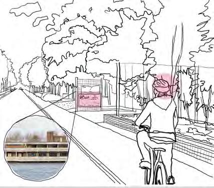
A summer ferry, sponsored by Lendlease, has been planned as part of the music festival sequence. They feel this will continue to help put Thamesmead on the map. To make this incentive work, Sho realizes he must work with people at the local timber yard to figure out how they can build a temporary jetty for a ferry stop on the Thamesmead waterfront. He offers them free festival tickets and his own volunteer time at their shop, in exchange for timber and nails to build the bridge.

MaptheonThamesmead

Weary that they don’t have enough volunteers to help with their rather ambitious program, they begin setting up tents, trailors, and temporary restrooms - marking space in the parking lot at the Thamesmead Village. They are so excited they set up a rap station in the middle of the parking lot.
141
Weeks later, the upset neighbors have been enjoying the music across the street, and the festival’s success creates another tension. Abbey Wood Station has been getting record passenger numbers coming through, and Peabody’s Village Center at Southmere gets more foot traffic. Southmere also has a substantial grocery store with a strong community of residents.
Morrisson’s sales are declining, and they agree to lease some of the warehouse to the artists at Bow OverArts.


HarkisonNatasha142
the next year, the artists capture several spaces in the parking lot. They make lease deals with Lendlease to make this happen. Lendlease is hopeful that the artists can reinvigorate their town center, and though cautious, are willing to give them a chance. Morrisson’s makes a lease agreement with the artists, and the film and TV production use gets transferred into the space.

Six months later, Pets & Home and Next are reconsidering their lease offer and have decided to relocate to another shopping center. The artists can capture more square footage to move their music production uses indoors.

MaptheonThamesmead


143
The neighbors once again complain about all the foot traffic coming through the area, and there was an accident on the main road. The artists, again, have a meeting with the neighbors to talk about a resolution. Sho even makes a new artist friend from within the neighborhood, although they ask for a Five Guys and H&M be added to the ongoing shopping center program. Sho is confused about the requests and saddened about the accident on the main road. He promises the neighbors that he will at least go to the City to try and figure out a solution to make the road safer..
A year later, Morrison’s sales continue to drop. They notice the vibrancy of the new mini-artist’s village, with many people coming and going to visit the local presence, enjoying the food trucks and live music every Thursday. In a final negotiation, they make a last lease agreement with the neighbors. This time, the space will house a creative workshop for painting and sculpting.
HarkisonNatasha144
The composite map shows us the ways that usual urban spaces can be reconfigured to accommodate different uses. A new village is taking roots along the Thamesmead waterfront. It is now January 31st, 2025. The artists are tired of commuting and are eager to live near their workspace. Sho has gotten so busy in the music production studio that he has forgotten about reaching out to the City re: the main road design. He thinks he may be able to redeem himself if he can work with the tired artists to make a plan to bring to the City. Sho calls a meeting with the artists and the neighbors in the parking lot office to create a framework plan.


145 Solidspace, a local small-scale builder, sets up their office in the parking lot, and the first part of phase 1 introduces 40 modular housing units set up around a shared courtyard. The film producers are ecstatic about living close to where they work and create. It only takes 3 months to build. The existing gas station is now being reappropriated as a public space, and the City is interested in alterative uses for the site. The arrangement of shipping containers in a linear court allows residents to stack the modular units. Areas adjacent to the loop road are to serve as fully public, entrepreneurial spaces and retail nodes. A green axis and trail connects the lakefront area to the canal trails, and also facilitate drainage from the parking lot. With the City’s interest in Sho’s proposal for downsizing the main roads, they begin to analyze the existing conditions to think about where possible bicycle routes might fit in. With the extensive and successful bus routes already in place, some challenges have come up with local authority and the neighbors.
MaptheonThamesmead


HarkisonNatasha146
The modular housing area is now considered a prominent artist’s village well-known in Thamesmead and has been designated as a conservation area. Lendlease agrees to preserve the artist’s village and help maintain its identity.


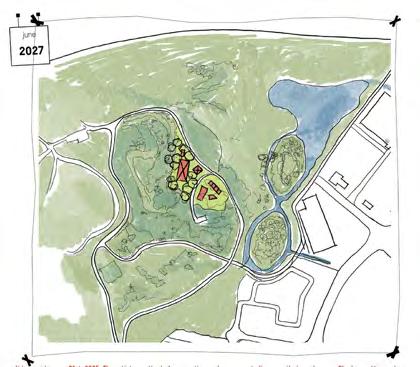
The village continues to grow throughout the main parking lot. Sho has worked with the City to rid the gas station, and although he knows about the consequences with the gas station site, they still take the risk to build incremental housing in its have passed, a community has now developed, and education has been a hot topic among the group. Sho is able to work with Bow Arts and EcoSchools, who has been actively seeking out spaces for forms of nature based education.
Twoplace.years

Reflections 147 Sowmya Parthasarthy Director, Urban Design & Masterplanning, Arup London
Thamesmead Waterfront is an extraordinary project. An unprecedented opportunity to design and develop a new town at the doorstep of both London and the Thames Estuary. Indeed, as the studio project subtitle notes, an opportunity to extend and mend the original Thamesmead district. Planning for the future of Thamesmead demands a wide lens and a holistic approach. It challenges you to think beyond your discipline. It requires bold thinking and collective innovation. It offers the scale and opportunity to be a model for sustainable urbanism fit for our times and the future. So, what kind of place should Thamesmead be? On the one hand, the type of places that people love has not changed for centuries. Affordable homes, good schools, walkable streets, welcoming open and green spaces, walkable neighborhoods, vibrant local and town centers, a sense of community, wellproportioned and beautiful buildings, and a well-understood hierarchy between public, semi-public, and private space. The old principles of good urban design are all still valid. But we expect a lot more from our places and cities now. 24/7 digital connectivity, on-demand services delivered to our door, data at our fingertips driving everyday decisions, healthy lifestyle opportunities, diverse cultural experiences, and new working patterns. And in today’s context, our places must also fulfill the aspirations (and requirements) for decarbonization, climate resilience, biodiversity, health, and social value. Such sites can only come to life through open-minded collaboration. 148
149Urban design has always been a multidisciplinary endeavor, and nowhere is this tested more strongly than at Thamesmead. I was impressed to see this focus on interdisciplinary, holistic thinking at the center of the design studio brief. The early stage of baseline assessment saw the students recognize and embrace this element with wellresearched and well-presented findings around climate change, water systems, transport connectivity, demographics, and various socio-economic indicators. I was interested to see how some of these findings helped shape the design concept in later stages of work – the link to the tidal waters of the Thames was a principal determinant, as was the desire to make a well-connected community based on walking, cycling, and public transport. At times, I felt that the sheer volume and availability of data presented at the assessment stage obscured more than it clarified. Students of urbanism must learn to work through this complexity, to balance analytical thought (populating the spreadsheet) with an intuition for design proposition (sketching the idea). Global drivers of change are critical considerations for city makers, but are we placing enough value on ‘smaller’ everyday experiences? As professional consultants, we have to navigate multiple perspectives and prioritize objectives during our work. While working on Thamesmead, city-level stakeholders overwhelmingly spoke about housing provision, net-zero targets, flood management, and design quality. Residents said of not having an ATM at walking distance, not being able to walk to the river, and lack of places for young people to hang out. Our job as urban designers is to make sure that all voices are heard, and all scales are considered –as a profession; we are still learning to do that well.
ParthasarthySowmyaI was also keenly interested in how the students translated early findings and ambitious sustainability aspirations into design ideas, spatial layouts, and specific proposals. For the most part, the rigor with which the students built the narrative was credible. But in this context, I would like to observe how easy it is to make assumptions about performance outcomes of places without following up on testing if that’s true. Shouldn’t urban designers do the equivalent of a building post-occupancy analysis? I am sure we would all learn a Aslot.design professionals working for the ‘client’ responsible for ‘delivery,’ we are accountable for translating utopian design concepts and highlevel sustainability ambitions into tangible actions. Design studios and university research can play a huge role in testing and exploring the sustainability performance of our places and communities and provide a body of guidance for change over time.
150
I want to acknowledge the challenge of undertaking a studio project so dependent on understanding local context during the pandemic, preventing students from experiencing the site in person. Under the circumstances, the understanding of context and outcomes was commendable. A final observation: I enjoyed seeing the group dynamics of the design ‘teams’ and how they navigated the brief and divided tasks amongst themselves. It was not unlike how professional teams organize themselves, and the same tension between creative collaboration and individual input under the pressure of time was well-replicated. I hope that in itself was a good learning experience!
CopyrightMehrotra©2020
Thamesmead: the town of tomorrow, today Instructors
Report Design
Acknowledgments
Text and images © 2022 by their authors.
Harvard GraduateUniversitySchoolof Design 48 Quincy gsd.harvard.eduCambridge,StreetMA02138
Editor
Natasha Harkison Sai Joshi Report
Kathryn Firth
President and Fellows of Harvard College. All rights reserved. No part of this book may be reproduced in any form without prior written permission from the Harvard University Graduate School of Design.
The editors have attempted to acknowledge all sources of images used and apologize for any errors or omissions.
Rahul
Extending Mending
and
Kathryn SaiNatashaFirthHarkisonJoshi
Dean and Josep Lluís Sert Professor of Architecture Sarah Whiting Chair of the Department of Urban Planning and Design
Gordon Davis, St Paul’s Academy Nadia Kassab Oghlo, Peabody
Guest Speakers Selina Mason, Director of Urban Design, PaulaLendleaseHirst, Strategy Director, Project Manager, Thamesmead Consultant Team Sowmya Parthasarthy, Director of Masterplanning and Urban Design, Arup Richard de Cani, Global Planning Leader, IanArupCarradice, Director, Arup Ben Smith, Director for Energy and Climate Change, Arup Dr Phil Askew, Director Landscape & Placemaking, Peabody Ellen Halstead, Director of Strategy & Programme for Thamesmead, Peabody John Lewis, Executive Director for Thamesmead, Peabody Adriana Marques, Head of Cultural Strategy for Thamesmead, Peabody Kate Willard, OBE, Thames Estuary Envoy and Chair of the Thames Estuary Growth Board
Final Review Critics Anne Tate, RISD Brie Hensold, Agency LP David Gamble, Harvard GSD Ian Carradice, Arup Jungyoon Kim, Harvard GSD Rodrigo Guerra, NBBJ Selina Mason, Lendlease Sowmya Parthasarathy, Arup Will Hunter, Loeb Fellow, Harvard GSD Workshop Liaisons


