

Assessingecologicalandsocio-politicalfactorsinsite
selectionforocelotreintroductioninTexas
LindsayA.Martinez 1 |JasonV.Lombardi 2 |GarrettPowers3 | AmandaD.Anderson3 |TylerCampbell4 |RoelR.Lopez3
1DepartmentofRangeland,Wildlife,and FisheriesManagement,TexasA&M University,CollegeStation,Texas,USA
2CaesarKlebergWildlifeResearch Institute,TexasA&MUniversityKingsville,Kingsville,Texas,USA
3TexasA&MNaturalResourcesInstitute, TexasA&MUniversity,CollegeStation, Texas,USA
4EastFoundation,SanAntonio, Texas,USA
Correspondence
LindsayA.Martinez,Departmentof Rangeland,Wildlife,andFisheries Management,TexasA&MUniversity, 495HorticultureRd,CollegeStation,TX 77843USA.
Email: lindsay.martinez14@gmail.com
Presentaddress
JasonV.Lombardi,WildlifeHealth Laboratory,CaliforniaDepartmentofFish andWildlife,RanchoCordova, California,USA.
Fundinginformation
USFishandWildlifeService;TexasA&M UniversityDepartmentofRangeland, Wildlife,andFisheriesManagement
Abstract
Wildlifereintroductionsiteselectionrequirestheconsiderationofnotonlya species'ecologybutalsosocio-politicalfactorsthatmayimpactconservation efforts.Thesesocio-politicaldimensionsmaybeespeciallyimportantfor endangeredcarnivorereintroductionsonprivatelandsintheUnitedStates, wherelandownersupportforthereintroductionisanecessitygivenlandowner concernsaboutecologicalandlegalimpactsofcarnivorerestoration.We designedanassessmenttoidentifypotentialsitesforreintroductionofthefederallyendangeredocelot(Leoparduspardalispardalis)inTexas,astatewhere over97%oflandsareprivatelyowned.WeincorporatedInternationalUnion forConservationofNaturerecommendationsintoageospatialanalysisevaluatingpotentialreintroductionsitesbasedonsitesize,ecologicalandlifehistoryrequirementsofocelots,potentialnaturalandanthropogenicthreats,and thesocio-politicalcontextofeachsite.Weidentifiedthefivehighest-ranking sitesthathadspecies-specificsuitablelandscapestructureofwoodycover, fine-scalevegetativecover,minimalnaturalandanthropogenicthreats,and thatpresentlandownershippatternsthatarelogisticallyfeasibleforconservationplannerstonavigate.Ourassessmentprovidedinformationforocelot conservationplanningandestablishedaframeworkforincorporatingprivate landdataintolarge-scaleassessmentsofwildlifereintroductionsitesonprivate lands.
KEYWORDS
conservationplanning,mammals,NorthAmerica,privatelands,remotesensing,threatened species
1 | INTRODUCTION
Felidsarecommonsubjectsofconservationreintroductionprogramsduetofelidpopulationdeclinesandsevere rangecontractions,theimportanceofrestoringthe
ecologicalrolesofpredatorspecies,andthehighintrinsic valueandassociatedpublicinterestinconservingfelids (Seddonetal., 2005).Thoughfelidreintroductions arecommon,theyarenotalwayssuccessful,andthepoor performanceofmanywildlifereintroductionefforts Received:30May2023Revised:19February2024Accepted:27February2024
CONTRIBUTEDPAPER
DOI:10.1111/csp2.13113
CreativeCommonsAttribution License,whichpermitsuse,distributionandreproductioninanymedium,provided theoriginalworkisproperlycited.
ConservationScienceandPractice publishedbyWileyPeriodicalsLLConbehalfofSocietyforConservationBiology.
2024;e13113. wileyonlinelibrary.com/journal/csp2 1of15 https://doi.org/10.1111/csp2.13113
Thisisanopenaccessarticleunderthetermsofthe
©2024TheAuthors.
ConservationScienceandPractice.
suggestsaneedforimprovedplanning(Fischer& Lindenmayer, 2000;Juleetal., 2008;Thomas etal., 2023).Whilereintroductionsiteselectionclearly mustincludeanevaluationofecologicalandlifehistory requirementsforspeciessurvivalandpopulationestablishment,socio-politicaldimensionsmustalsobeconsideredtofullyevaluatethefeasibilityofareintroduction program(Behretal., 2017;Carveretal., 2021;Ditmer etal., 2022;Grayetal., 2017;IUCN/SSC, 2013;Reading etal., 2002;Watkins, 2020).Thismaybeespecially importantforcarnivorereintroductions;globally,reintroductionplanningeffortsforfelidsorothercarnivores mustaddresspotentialhuman-wildlifeconflictconcerns, suchasthepossibilityofdepredationofwildlifepopulationsonprivatelyownedlivestock(Drouilly& O'Riani, 2021).Whenassessingcarnivorereintroduction sites,accountingforsocio-politicaldimensionssuchas presenceofprotectedareas,spatialpatternsinlandownership,expectedcarnivore-humantolerance,andlivestockstockingratescanprovideaclearerpictureofthe potentialsocio-politicalissuesatdifferentreintroduction sitesandtheecological-socialtradeoffspresentateach site(Connolly&Nelson, 2023;Ditmeretal., 2022; Pratzeretal., 2023).
AcrossNorthAmerica,levelsofprivatelandownershipvary,andprotectedlandscansometimesfailtomeet conservationrequirements(Clancyetal., 2020;Jenkins etal., 2015).IntheUnitedStates,endangeredspecies conservationmayalsobecomplicatedbysomeprivate landowners'concernsthatthepresenceofspeciesprotectedundertheEndangeredSpeciesAct(ESA)ontheir landswillleadtofederalregulationsthatrestrictlanduse andhabitatmodifications(Hansenetal., 2018).Thiscan makeconservationandrestorationofendangeredspecies intheUnitedStatesdifficult.Historically,someprivate landownersintheUnitedStateshavemanagedtheir landstopreventoccupancybyendangeredspeciesor haveconcealedinformationconcerningpresenceof endangeredspeciesontheirproperties(Lueck& Michael, 2003).Assuch,endangeredspeciesreintroductioneffortsintheUnitedStatesthatoccuroutsidepubliclyownedorotherdedicatedprivateconservationlands (e.g.,landtrustsandpreserves)requireestablishingregulatoryassurancedocumentation(e.g.,SafeHaborAgreements)withlandownerstoobtaintheirsupportfor reestablishmentofendangeredspeciesontheirproperties (Bork, 2011).
IntheInternationalUnionforConservationof Nature(IUCN)SpeciesSurvivalCommission(SSC) guidelinesforspeciesreintroductions(IUCN/SSC, 2013), IUCNrecommendsreintroductionsites:(1)arelarge enoughtosupportaviablepopulationofreintroduced species;(2)meetaspecies'ecologicalneedsatallrelevant
scales;(3)havereducedthreatstothespecies(including abatementofthehistoricthreatsthatcausedthedecline ofthespeciesandreducedthreatsfrompresentcatastrophicevents);and(4)aresocio-politicallyfeasiblefor reintroduction(IUCN/SSC, 2013).Inshort,IUCNsuggestsconsideringecology/lifehistory,size,abatementof humanandnaturalthreats,andsocio-politicalfactorsin choosingareintroductionarea.
Publishedassessmentstoidentifysitesforfelidreintroductionshavefocusedonecologicalfactorssuchas landcovertypeorvegetationcommunity,preybase,size andconnectivityofhabitat,andremotenessfromhuman encroachmentonhabitat.Examplesincludeassessments ofFloridapanther(Pumaconcolorcoryi)reintroduction sitesinFlorida(Thatcheretal., 2006);tigerreintroductionsitesinChina(Hebblewhiteetal., 2012;Qin etal., 2015);Europeanwildcat(Felissilvestris)reintroductionsitesinEurope(Klaretal., 2008);EurasianlynxreintroductionsitesinEurope(Hetheringtonetal., 2008; Schadtetal., 2002);IberianlynxsitesontheIberianPeninsula(Garroteetal., 2020);andreintroductionsites throughoutAsiaforseveralleopardsubspecies(Chiang etal., 2015;Gardener, 2020;Hebblewhiteetal., 2011). However,thesefelidreintroductionsiteassessmentslack considerationofsocio-politicalfactorsintheirdeterminationofsuitablereintroductionsites.
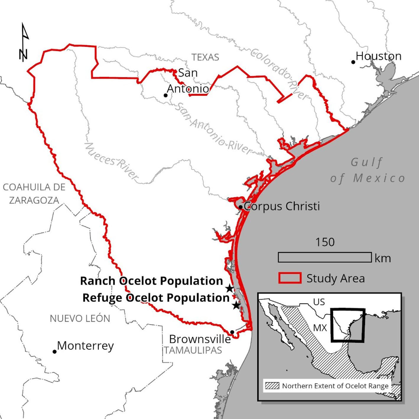
Theocelot(Leoparduspardalis spp.)isamediumsizedfelidconsideredleastconcernrange-widebutclassifiedasfederallyendangeredinseveralrangecountries, includingtheUnitedStates,wherepopulationexpansion viareintroductionisneededforrecovery(USFishand WildlifeService, 2016).IntheUnitedStates,ocelotshistoricallyoccupiedArizona,variousregionsofsouthern, central,andeasternTexas,andthewesternpartsof ArkansasandLouisiana(USFishandWildlife Service, 2016).However,bythemid-20thcentury,habitat loss,pettrading,furtrapping,andpredatorcontrolpracticesnearlyextirpatedocelotsfromtheUnitedStates (USFishandWildlifeService, 2016).Today,the UnitedStateshasonlytwoknownbreedingocelotpopulations,whicharetheorizedtonumberupto100individualspersistingindeepSouthTexasalongtheGulfof Mexico(Figure 1,Lombardietal., 2021).Thelarger oftheremainingpopulationsinTexasistheRanchOcelotPopulation,whichexistsonprivatelyownedworking ranchesinWillacyandKenedyCounties.Thesmaller RefugeOcelotPopulation(16–20ocelots)isfoundinand aroundLagunaAtascosaNationalWildlifeRefugein CameronCounty(Lombardietal., 2022).
ThetwoTexasocelotpopulationsoccurinvegetation communitiescontainingliveoak(Quercusvirginiana), palm(Sabal spp),andmesquite(Propsisglandulosa) woodlandsandforestswithopentodensepatchesof
2of15 MARTINEZ ETAL 25784854, 0, Downloaded from https://conbio.onlinelibrary.wiley.com/doi/10.1111/csp2.13113, Wiley Online Library on [26/03/2024]. See the Terms and Conditions (https://onlinelibrary.wiley.com/terms-and-conditions) on Wiley Online Library for rules of use; OA articles are governed by the applicable Creative Commons License
FIGURE1 Thestudyareaassesses potentialocelotreintroductionsitesin thelower116,480km2 ofTexas, UnitedStates,whichisattheperiphery ofthenorthernhalfoftheocelot's (Leoparduspardalis)geographicrange andcurrentlyhasonlytwoknown populations.
thornshrubandherbaceous(i.e.,cordgrass[Spartina sp.] andinvasiveguineagrass[Megathyrsusmaximus]) understories(Lehnenetal., 2021;Lombardietal., 2021; Sergeyevetal., 2022).Suitablelandscapestructureof woodycoverforocelotsinTexashasbeendescribedas large,adjacentwoodypatchesoccurringinlowdensities onthelandscape(Lombardietal., 2021).Acrosstheir geographicrange,ocelotsinhabitavarietyofmixedand densevegetationcommunitiesandforestedpatches, includingtropicaldeciduousforests(Lombardi,Haines, etal., 2022),pine-oakwoodlands(Gomez-Ramírez etal., 2017),tropicalbroadleafforests(Satteretal., 2019), savannaandgalleyforests(Pavioloetal., 2015)andsemiaridoakandshrubcommunities(Lehnenetal., 2021; Lombardietal., 2021).
Thesmallknownrangeofocelotpopulationsinthe UnitedStates afewcountiesincoastalsouthern Texas makesocelotsvulnerabletopotentialextirpation duetoalocalcatastrophicevent,suchasadiseaseoutbreak,mega-wildfire,orseverefloodingfromamajor hurricanes.Majorhurricanesareaparticularconcernfor Texas'socelots,whichoccurnearlow-elevationareas (<50m)neartheintercoastalLagunaMadreoftheGulf ofMexico.Inthefuture,climatechangemayincrease wildfirerisk(DiVirgilioetal., 2019)andsealevelrise
(Sweetetal., 2022)andleadtoincreasedfrequencyand severityoftropicalcyclonesandassociatedflooding (Knutsonetal., 2020),whichmaythreatenspeciesoccurringalongcoastlines.
Thereintroductionofanadditional,geographicallydistinctocelotpopulationinTexasisneededtoensuresurvivalofocelotsinTexasandintheUnitedStatesinthe caseofacatastrophiceventsuchaswildfire.ItalsoisnecessarytoincreasethenumberofocelotsintheUnited Statestoachieverecoveryfromendangeredspeciesdesignation(USFishandWildlifeService, 2016).Selectionofa siteforreintroductionofanadditionalpopulationofocelotsintohistoricbutunoccupiedhabitatinsouthernTexas providesuniquechallengesforafelidreintroductionplanningeffortbecauseover97%oflandinTexasisunderprivateownership(LeslieJr, 2016;Lombardietal., 2022).As such,privatelandsalmostcertainlymustplayarolein ocelotreintroductioninTexas,andprivatelanddynamics suchasownershipfragmentationandlandownerconcerns aboutlegalimplicationsofendangeredspeciespresence mustbeaccountedforinsiteselection.Thisnecessitates specialconsiderationofsocio-politicalfactorswhendeterminingareintroductionsite,asbothsupportandcoordinationfromprivatelandownersareneededtoimplement anocelotreintroductioninTexas.
MARTINEZ ETAL 3of15 25784854, 0, Downloaded from https://conbio.onlinelibrary.wiley.com/doi/10.1111/csp2.13113, Wiley Online Library on [26/03/2024]. See the Terms and Conditions (https://onlinelibrary.wiley.com/terms-and-conditions) on Wiley Online Library for rules of use; OA articles are governed by the applicable Creative Commons License
Amulti-institutionalcollaborativestudy(https:// RecoverTexasOcelots.org)wasestablishedin2021to partnerstateandfederalwildlifeagencies,academicinstitutions,conservation-minded non-governmentalorganizations,andprivatelandownerstoexaminethefeasibilityof reintroducinganadditionalocelotpopulationtoaportion ofitshistoricbutnowunoccupiedrangeinsouthernTexas withinandproximatetotheecoregionscurrentlyoccupied byocelotsinTexas.Aninitialobjectiveintheeffortwas theuseofIUCNguidelinesforreintroduction(IUCN/ SSC, 2013)inalarge-scalegeospatialassessmenttoidentify possiblereintroductionsitesbasedonspeciesecologyand socio-politicaldimensions.Wedesignedanassessmentto identifysiteswithhighecologicalsuitabilityforocelot occupancyaswellasminimalnaturalandanthropogenic threatstoocelots.Furthermore,recognizingtheneedfor sitestobesocio-politicallyandlogisticallyfeasibleforocelotreintroduction,weconsideredpatternsinlandownershiptoidentifythemostsuitablepotentialreintroduction sites.Collectively,weusedthisinformationtoidentify potentialreintroductionsitesthatwereevaluatedascandidatesforfutureocelotreintroductions.Ourworkwasused toselectasiteforinitialocelotreintroductioneffortsin southernTexas,andithasprovidedamodelfortheincorporationofprivatelandinformationintoassessmentsof potentialwildlifereintroductionsitesthatoccurinregions composedpartlyorevencompletelyofprivatelands.
2 | METHODS
2.1 | Studyarea
Weanalyzedapproximatelythesouthernone-third (lower46counties)ofTexas(approximately116,480km2; Figure 1)asthisareaispresumedtobehistoricocelot habitat(USFishandWildlifeService, 2016).ThesouthernthirdofTexasencompassesavarietyofecoregions. Thenorthernmostportionofthestudyareaisthe EdwardsPlateauregion,whichcontainsashejuniper (Juniperusashei)andliveoakwoodlandsandcanyonlands.Thecenterofthestudyareacontainsthesouthern Texascoastalplainsregion,whichisprimarilyliveoak andmesquitewoodlandswithextensiveTexasTamaulipanthornshrubcommunities.Finally,thesouthernmostpartoftheregion whichincludestherangeof existingocelotpopulations containstheLowerRio GrandeValleyandRioGrandeDeltaofthewesternGulf coastalplain,whichischaracterizedbysubtropicaland tropicalvegetationcommunities,extensiverow-cropagriculture,andahighlyurbanizedbi-nationalmetropolitan area(Griffithetal., 2007;LeslieJr, 2016).
Wetookatwo-stepapproachtoassessocelotreintroductionsitesinthestudyarea,beginningwithan
assessmentofrelevantfactorsatamacro-scalefollowed byanassessmentofhabitatatafinescale.Metricsatboth scaleswerecalculatedusingRstatisticalsoftware(RCore Team, 2020).Theapproachesinourstepwiseprocessare describedbelow.
2.2 | Macro-scaleassessment
2.2.1|Ecological/lifehistoryfactors
Weusedpublishedassessmentstoidentifylandscapescaleecologicalfactorsthatpredictocelothabitatin Texas.Ocelotsuselargepatchesofwoodycoverwith characteristicmeasuresoflowlandscapeshapeindex, aggregationindex,edge,andpatchdensityinadditionto highpercentagesofwoodycoverandlargestpatchindex (seeTable2inLombardietal., 2021).Usingthesemeasures,Lombardietal.(2021)publishedamapofsuitable landscapestructureofwoodycoverforocelotsinthe southernmost19countiesofTexas.Wereplicated themethodsfromLombardietal.(2021)usingtheocelot'soptimalrangeofvaluesforeachlandscapemetricto expandthemapofhighlysuitablelandscapestructureof woodycoverforocelotsacrossourentirestudyarea.We chosetolimitourconsiderationofmacro-scaleecological factorstolandscapecovertype(woody,herbaceous,bare ground,cropland,urban,orwater)andstructure (Lombardietal., 2021).Wedidnotincludeassessments ofpreydistributionsbecauseocelotsaredietarygeneralists(deVillaMezaetal., 2002;Morenoetal., 2006).In SouthTexasspecifically,ocelotshavebeenfoundtoconsumeninespeciesofsmallrodentspluswhite-taileddeer (Odocoileusvirginianus),black-tailedjackrabbit(Lepus californicus),easterncottontail(Sylvilagusfloridanus), andseveralspeciesofbirdsandreptiles(Booth-Binczik etal., 2013).Whileamodelofpreydistributionmaybe necessaryforidentifyinghabitatforadietaryspecialist, webelievedtheocelot'sgeneralistdietdidnotnecessitate suchanevaluation.
2.3 | Naturalandhumanthreatsto ocelots
Wenextremovedareasofsuitablelandscapestructureof woodycoverwhereareintroducedocelotpopulation couldbenegativelyimpactedbynaturalandhuman threats.First,weconsideredmajorhurricaneimpacts (i.e.,stormsurgeflooding)becauseonegoalofthereintroductionistoestablishanocelotpopulationthatwill notbeimpactedbystochastic,andpotentiallycatastrophic,majorhurricanes.WeusedtheNationalOceanicandAtmosphericAdministration'sSea,Lake,and
4of15 MARTINEZ ETAL 25784854, 0, Downloaded from https://conbio.onlinelibrary.wiley.com/doi/10.1111/csp2.13113, Wiley Online Library on [26/03/2024]. See the Terms and Conditions (https://onlinelibrary.wiley.com/terms-and-conditions) on Wiley Online Library for rules of use; OA articles are governed by the applicable Creative Commons License
OverlandSurgesfromHurricanesmodel(SLOSH; Zacharyetal., 2015)toidentifyareasatriskofinundationduringstormsurgesassociatedwithhurricanes.We usedSLOSH'sMaximumoftheMaximumEnvelopeof WaterCategory5output,whichisanensembleproduct ofmaximum “worse-casescenario” stormsurgepredictionsfrommultiplehurricanesimulationsfortheSaffirSimpsoncategory5(Stockdon&Thompson, 2007).We thenremovedsuitablelandscapestructureofwoody coverwheremaximumstormsurgeinundationwaspredictedtobeatleast0.30meters(onefoot)aboveground leveltoaccountforpotentialfloodingofocelothabitat.
Next,weconsideredhumanthreatstoocelots.Given thatroadwaysarethelargestknownsourceofmortality fortheRefugeOcelotPopulationinTexas(Blackburn etal., 2022)andthatocelotresourceuseisgreatestat least1kmfromhigh-trafficroadways(Vealsetal., 2022), weremovedsuitablelandscapestructureofwoodycover within1kmofanyhightrafficroadway,definedasa roadwaywithAnnualAverageDailyTrafficofatleast 1000vehicles/day(TexasDepartmentofTransportation, 2021).Then,weaccountedforpotentialhabitatlossdue tolanddevelopmentbyremovinganysuitablelandscape structureofwoodycoverpredictedtobedevelopedby 2050accordingtotheIntegratedClimateandLand-Use Scenariosdataset(Version2.1.1withSSP2andRCP4.5 Pathways,USEnvironmentalProtectionAgency, 2010).
Finally,weidentifieddistinctpatchesofsuitablelandscapestructureofwoodycoverbasedontheremaining suitablelandscapestructureavailablefollowingtheprevioussteps.Todothis,weusedamovingwindowanalysis todeterminetheproportionofsuitablelandscapestructureofwoodycoverwithinaneighborhood(window)of eachsuitablecell.Weusedawindowsizeof0.86km2, whichrepresentedabalancebetweencomputersystem processingrequirementsandthedailymovementrange ofanocelot,whichhasbeenestimatedat1.5km2 in Texas(Blackburnetal., 2022).Cellsofsuitablelandscape structureofwoodycoverwithaneighborhooddensityof lessthan75%suitablelandscapestructureofwoodycover wereremovedfromfurtherconsiderationwhileremainingcontinuouscellsweredelineatedintodiscrete patches.
2.4 | Rankingpatchesbyincluding socio-politicalfactors
Afteridentifyingcontinuouspatcheswithsuitablelandscapestructureofwoodycoverdistinctfromlikely threatstoocelots,weuniquelyidentifiedandranked patchesbasedonpatchsize(km2),threatstoocelots,and socio-politicalconsiderationsbyusingSpatialAnalyst
toolsinArcGISPro(ESRI, 2020).Toaccountforsociopoliticalfactorsthatmayinfluencethefeasibilityofocelotreintroductiononprivatelands,weincorporatedland ownershipdata(TexasNaturalResourceInformation System, 2021).Weidentifiedindividuallandholdings (parcels)withindiscretepatchesofsuitablelandscape structureofwoodycover,consideringadjacentparcels ownedbythesamelandownerasoneparcel,and extractedthesizeofeachparcel.Wealsodistinguished allareasofprotectedlandunderfederal,state,orlocal ownershiporprivateconservationorganization (e.g.,landtrusts)ownershipthatwerewithin25kmof eachpatch(TexasNaturalResourceInformation System, 2021).Webelievedthat,whenimplementingan ocelotreintroductionandseekinglandscape-scaleconservation,itispreferabletominimizeownershipboundaries andtocoordinatewithasmallnumberoflandowners whoownlargeparcelsversusmanylandownerswho eachownasmallparcel.Furthermore,weassumedthat eachreintroductionpatchneedsalargeownershipparcel toserveasacentrallocationforocelotreintroduction activities.Wedefinedlargeownershipparcelsasland holdingsofatleast25,000acres(approximately101km2), whichwouldbelargeenoughtosupportabout8–10male ocelothomerangeswith2–3femaleocelotsper male(USFishandWildlifeService, 2016.).
Foreachpatch,wecalculatedseveralmetrics:(1)area (km2)ofsuitablelandscapestructureofwoodycover, (2)degreeoflandownershipfragmentationinthepatch (i.e.,areaofpatchdividedbythenumberofuniquelandownersinthepatch),(3)area(km2)ofthepatchfound withinlargeownershipparcelsofatleast25,000acres (approximately101km2),(4)size(km2)ofthelargest ownershipparcelinthepatch,and(5)minimumdistance (m)betweentheboundaryofthelargestparcelinthe patchandthenearesthightrafficroad.Foreachpatch, wecalculatedthenormalizedvalueofeachmetricby subtractingtheminimumvalueofallpatchesfromthat patch'svalueandthendividingbythedifferencebetween themaximumandminimumvaluesofallpatches.Each patch'sfinalscoringwascalculatedasthemeanofallfive normalizedmetricvalues,whichwereallconsidered equallyimportant.Patcheswererankedbasedontheir meannormalizedscore,andthefivehighest-scoring patcheswerefurtherevaluatedbasedonsocio-political considerationsandfine-scaleassessmentofecology.
Afteridentifyingthehighest-scoringpatches,wealso gatheredhigh-levelsocio-politicalinformationaboutthe patchestoprovideinformationaboutprivatelandowner valueswithineachpatchandtoinformfuture landowneroutreachatpatches.Weobtainedgeneral informationaboutprivatelandownerswithinthepatches fromlocalprojectpartnerswhoparticipateinprivate
MARTINEZ ETAL 5of15 25784854, 0, Downloaded from https://conbio.onlinelibrary.wiley.com/doi/10.1111/csp2.13113, Wiley Online Library on [26/03/2024]. See the Terms and Conditions (https://onlinelibrary.wiley.com/terms-and-conditions) on Wiley Online Library for rules of use; OA articles are governed by the applicable Creative Commons License
landconservationandwildliferesearchinSouthTexas andarefamiliarwithlandownersthere.Thesepartners includedtheTexasParksandWildlifeDepartment (TPWD),CaesarKlebergWildlifeResearchInstitute (CKWRI)atTexasA&MUniversity-Kingsville,andthe EastFoundation,aprivatelandownerandmemberofthe SouthTexasPropertyRightsAssociation.Wequeried thesepartnersontheirknowledgeoflandowners'likely attitudestowardcollaboratingwithagenciesanduniversitiesonthereintroductionofafederallyendangeredcarnivorespeciesonandaroundtheirlands.Wedidnot conductaformalsurveyofalllandownersinthepatches orcontactanyspecificlandownersinthehigh-ranking patchestoavoidcreatingpossiblepublicconcernabout ocelotreintroductionduringtheearlyplanningstagesof theprogram.Webelievedthatdirectcontactwithspecific landownersinthepatcheswouldbeanecessaryfollowupactiononourassessmenttoprovidemoredetailed dataonthewillingnessoflandownerstoallowareintroductioneffortontheirlandsandtoparticipateinthe effort.
2.5 | Fine-scaleecologicalassessment
Afteridentifyingthetop-rankingpatches,weagain assessedecologicalfactors,thistimeevaluatingvegetation(includingwoodyandherbaceousvegetation)ata finescalewithinthehighest-rankingpatches.Weused LightDetectionandRanging(LiDAR)metrics (USGeologicalSurvey, 2018a, 2018b, 2018c, 2019)to identifyappropriatefine-scalevegetationcharacteristics forocelots.Weevaluatedtwovariablesderivedfrom AerialLiDARScan(ALS)thatmayinfluenceocelothabitatuseatafinescale:canopyheight(m)andunderstory vegetationdensity(Sergeyevetal., 2022).WeusedtheR packagesLidR(Version1.0.4;Rousseletal., 2020)and raster(version3.4-5;Hijmans&vanEtten, 2012)toprocessALSdataforthesemetricswithin30-mgridcells. Wecalculatedcanopyheightasthe95thpercentileelevationvalueinmetersabovegroundlevelforallpoints locatedwithineach30-mgridcell.Werepresentedvegetationdensityintheunderstoryusingthenormalizedrelativepointdensity(NRD)metric,whichisameasureof LiDARpointdensitywithinaspecificverticalstratum (USDepartmentofAgricultureForestService, 2021).We calculatedNRDwithineach30-mcellbydividingthe totalnumberofLiDARpointsbetween0.5and1mabove groundlevelbythetotalnumberofpointsbelow1m abovegroundlevel.Weselectedthisheightfilterbecause ocelots,whichstandabout0.5minheight,havebeen documentedselectingforvegetativecovernear1min heightwhilerestingandhunting(Sergeyevetal., 2022,
2023).Weappliedalogarithmictransformationtothe NRDvaluestoreduceskewnessindata.
Weidentifiedtheaveragecanopyheightandvegetationdensityatknownocelotlocationsusingdatafrom 12ocelots(4adultmales,8adultfemales)thatweremonitoredontwoprivaterancheswithintheRanchOcelot Populationfrom2017to2022(Lombardietal., 2021; Sergeyevetal., 2022).Monitoredocelotswereequipped withGPScollarsthatrecordedlocationsevery0.5–1h overadurationof4–9months(Lombardietal., 2021; Sergeyevetal., 2022).Wecharacterizedsuitablefinescalecoverforocelotsinthereintroductionpatchesas withinathresholdoftwostandarddeviationsfromthe meansforeachmetricmeasuredintheknownocelot locations(log-transformednormalizedvegetationdensity meanwas 2.23andstandarddeviation1.13;meancanopyheightwas5.83mwithstandarddeviation1.23m). Inthehighest-rankingpatchesofsuitablelandscape cover,weclassifiedpixelswithinthethresholdsforboth metricsassuitablefine-scalevegetativecoverforocelots. Then,weappliedthesamemovingwindowanalysisused earliertoidentifydenseandcontinuouspatchesoffinescalevegetativecoverwithinthehighest-rankingpatches ofsuitablelandscapecover.
Finally,weestimatedthecarryingcapacityforeach patchbasedonitsareaofidentifiedsuitablelandscape structureofwoodycover(maximumestimatedcarrying capacity),andfine-scalevegetativecover(minimumestimatedcarryingcapacity),andrecentpopulation estimatesincomparablehabitatsinNortheasternMexico ( 11.6ocelots/100km2;Lombardietal., 2022)and southernTexas(17.6ocelots/100km2;Lombardi etal., 2022).Thenorthernmostofthehigh-ranking patchesweidentifiedoccurintheTexasHillCountry, whichischaracterizedbyelevation>300manddeciduousandevergreenforests;therefore,wecalculatedcarryingcapacitytherebasedonestimatesfromthe mountainousareasoftheSierraTamaulipasinnortheasternMexico.TheCentralandSouthernpatchesweidentifiedhavesimilarvegetationcommunitiestothose currentlyoccupiedbyocelotsinsouthernTexas,sowe useddensityestimatesfromexistingocelotpopulations insouthernTexas(17.6ocelots/100km2;Lombardi etal., 2022)toestimatecarryingcapacityintheSouthern andCentralpatches.
3 | RESULTS
Wefoundthatthemajorityofourareaofinterestin southernTexashadsuitablelandscapestructureof woodycoverforocelots(Figure 2A)thatwasalsoremote fromanticipatedanthropogenicornaturalthreatsto
6of15 MARTINEZ ETAL 25784854, 0, Downloaded from https://conbio.onlinelibrary.wiley.com/doi/10.1111/csp2.13113, Wiley Online Library on [26/03/2024]. See the Terms and Conditions (https://onlinelibrary.wiley.com/terms-and-conditions) on Wiley Online Library for rules of use; OA articles are governed by the applicable Creative Commons License
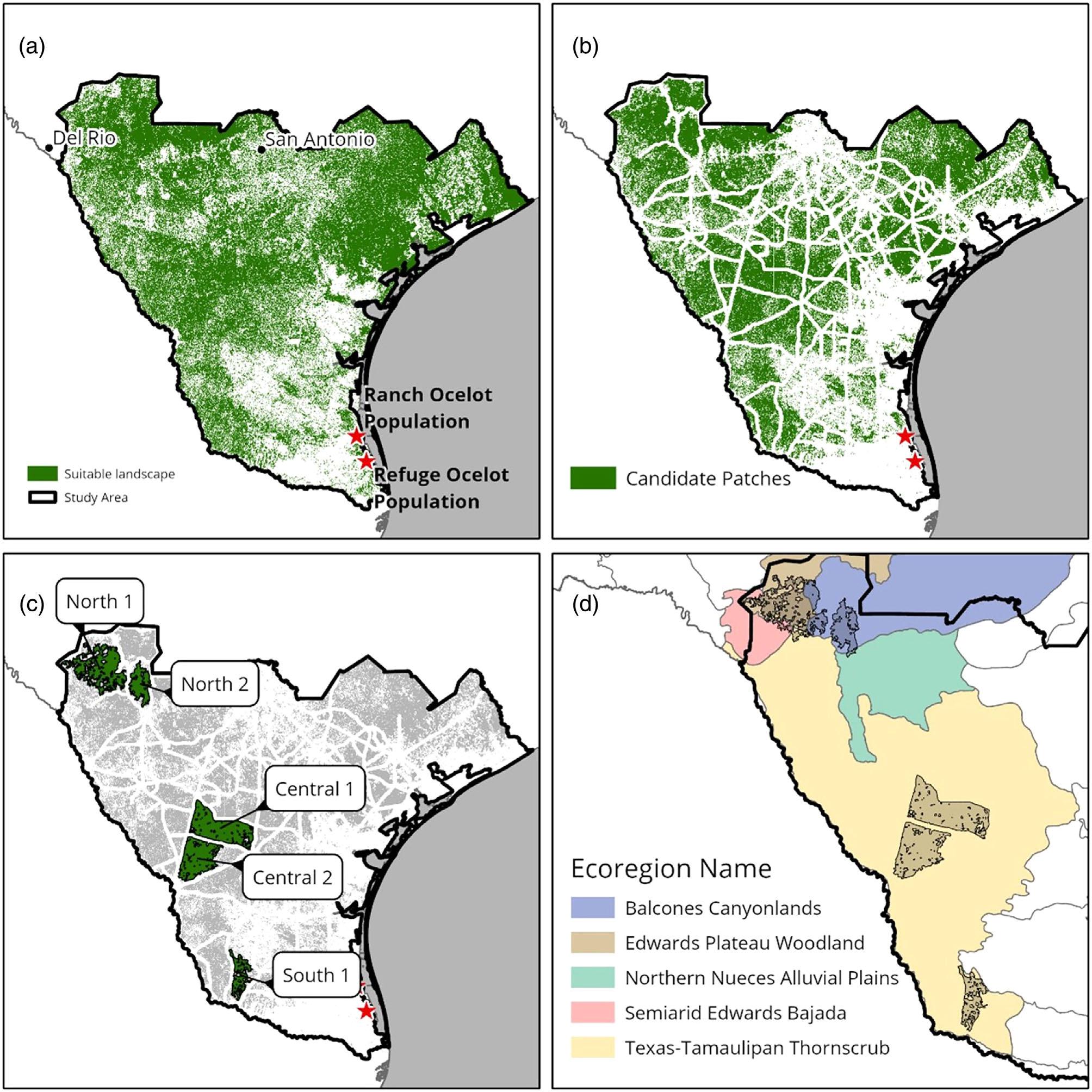
suitablelandscapestructureofwoodycoverthatremainedafterareaslikelytoimpactedbyhumanornaturalthreatstoocelots(i.e.,areas within1kmfromhigh-trafficroadwaysorareasoffutureurbandevelopmentorstormsurgefromCategory5majorhurricanes)were removed,(C)thehighest-rankingpatchesofremainingsuitablelandscapestructureofwoodycover(basedonpatcharea[km2],ownership fragmentation,areawithinlargeparcelsexceeding101km2,areaofthelargestsingleparcel,anddistancebetweenthelargestparcelanda high-trafficroadway),(D)andthelocationofhighest-rankingpatcheswithinecoregionsinTexas.
ocelotsthatmustavoidedinareintroduction(Figure 2B). Byrankingdiscretepatchesofsuitablecontiguouslandscapestructureofwoodycoverbasedonsize,degreeof landownershipfragmentation,totalareaoflarge (≥101km2)parcels,sizeofthelargestparcel,andremotenessofthelargestparcelwithineachpatchfromahigh-
trafficroad,wefoundthatfivepatchesemergedfromour criteriaasthehighest-rankingpossiblereintroduction sites(Table 1).Assessmentofcanopyheightandunderstoryvegetationdensityatafinescalewithinthesefive patchesusingLiDARshowedthatsuitablefine-scalevegetativecoverwaspresentinallpatches(Figure 3).The
MARTINEZ ETAL 7of15 25784854, 0, Downloaded from https://conbio.onlinelibrary.wiley.com/doi/10.1111/csp2.13113, Wiley Online Library on [26/03/2024]. See the Terms and Conditions (https://onlinelibrary.wiley.com/terms-and-conditions) on Wiley Online Library for rules of use; OA articles are governed by the applicable Creative Commons License
FIGURE2 Progressionofthemethodologyusedinourassessmentofpotentialocelot(Leoparduspardalispardalis)reintroductionsites inthesouthern46countiesofTexas,startingwith(A)allsuitablelandscapestructureofwoodycoverforocelots,(B)continuouspatchesof
TABLE1 Normalizedmetricandmeanscores,onascalefrom0to100,forthetopfivehabitatpatchesarereported.Higherscores indicateagreatersuitabilityrelativetoallotherpatches.
Patch
Areaofsuitable landscape structure Areawithinlarge parcels(>25,000 acres)
Sizeof largest parcel Distancefromthelargest parceltothenearest high-trafficroad Land ownership fragmentation Mean score
TABLE2 Areasofsuitablelandscapestructureofwoodycoverandfinescalevegetativecoverandestimatedmaximumandminimum carryingcapacityvalues,respectively,forthefivehighest-rankingpotentialocelot(Leoparduspardalispardalis)reintroductionpatches identifiedacrossthesouthern46countiesofTexas.Carryingcapacitieswerequantifiedbasedonthetotalavailableocelot-specificsuitable landscapestructure(maximum)andfinescalevegetativecover(minimum)basedonstudiesinsimilarhabitatandelevationalzonesin Texas(17.6/100km2 Lombardi,Sergeyev,etal., 2022)andNortheasternMexico(11.6ocelots/100km2;Lombardi,Stasey,etal., 2022).
Patch
Areasuitable fine-scale vegetative cover(km2)
Areafinescale vegetativecoverin largestsingle ownershipparcel inpatch(km2)
Areasuitable landscape structureofwoody cover(km2)
Estimatedocelot densityfrom literature
North11450181154811.6/100km2
North251914158811.6/100km2
fivepatcheshaveawidegeographicextentinTexas,and theyrepresentdiverseecologicalcommunities;delineationbasedonLevelIVEcoregions(USEnvironmental ProtectionAgency, 2013)showsthattheCentralpatches andSouthpatcharelocatedwithintheTexasTamaulipanthornshrubecoregionwhilethetwonorthernpatchesareatanexusbetweenBalconesCanyonlands,EdwardsPlateauWoodland,andSemiarid EdwardsBajadaecoregions(Figure 2D).
Theareaofsuitablelandscapestructureofwoody coverandfine-scalevegetativecovervariedbetweentop patches,asdidexpectedcarryingcapacitiesandland ownershippatterns(Table 2).TheNorthpatches (Figure 3A)wereadjacentpatchesseparatedbyahightrafficstatehighwaywithalarge,combinedareaofsuitablelandscapestructureofwoodycover(2136km2)and fine-scalevegetativecover(1969km2).Estimatedcarryingcapacitiesacrossbothareascombinedrangefrom 228.40to247.77ocelots(Table 2).TheNorthpatcheshad themostpotentialforconnectivitytoprotectedlands. Bothpatcheswerecomposedpartiallyofprotectedlands, andtherewerenetworksofprotectedlandstoboththe
Estimated minimum carrying capacity Estimated maximum carrying capacity
eastandwestofthepatches.Regardingprivatelands, TPWDbiologistsreportedthatmanylargelandownersin theareawereconservation-mindedandmaybeagreeable toanocelotreintroductionprojectonandaroundtheir lands.However,thelargestknownlandholdinginthe area,theBriscoeRanch,currentlyhasapubliccontroversyoverpropertyownership.
Thelargestidentifiedpatcheswerethecentral patches,whichwereadjacentbutseparatedbyahightrafficstatehighway(Figure 3B).Combined,thesetwo adjacentpatcheshadthelargesttractsofsuitablelandscapestructureofwoodycover(2780km2)andfine-scale vegetativecover(1921km2)withestimatedcombined carryingcapacitiesrangingfrom338.10to489.28ocelots (Table 2).ThepatchesareborderedbyanInterstate,state highways,andcountyFarm-to-Marketroads.Whilethere wereseverallarge(>101km2)privateparcelsinand aroundthepatches,therewasonlyoneprotectedareain Centralpatch1andnoneinCentralpatch2.Furthermore,therewerelimitedprotectedlandsinthevicinity oftheCentralpatches.Biologistsfromprojectpartners includingCKWRIandTPWDexpressedconcernabout
North129.9913.0120.5698.572.3432.90 North230.9515.9221.08100.001.5633.90 Central1100.0034.3127.3336.574.7640.59 Central276.30100.0073.5531.728.2657.97 South130.2822.8056.8749.252.0132.24
168.20179.57
60.2068.20 Central197871157717.6/100km2 172.13277.55 Central2943226120317.6/100km2 165.97211.73
63.8984.13 8of15 MARTINEZ ETAL 25784854, 0, Downloaded from https://conbio.onlinelibrary.wiley.com/doi/10.1111/csp2.13113, Wiley Online Library on [26/03/2024]. See the Terms and Conditions (https://onlinelibrary.wiley.com/terms-and-conditions) on Wiley Online Library for rules of use; OA articles are governed by the applicable Creative Commons License
South136312447817.6/100km2
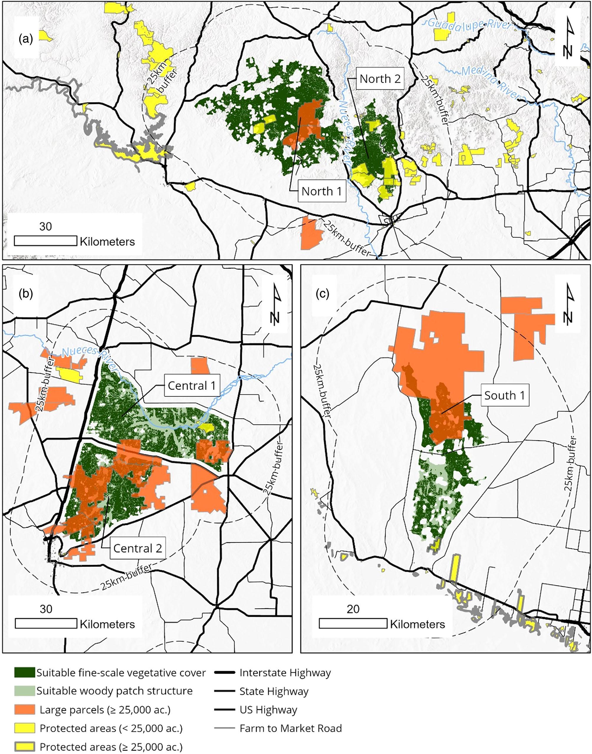
FIGURE3 Withinthefivehighest-rankingpotentialocelot(Leoparduspardalispardalis)reintroductionpatchesidentifiedacrossthe southern46countiesofTexas,suitablefine-scalevegetativecover,identifiedusingLiDARanalysisofcanopyheightandshruband herbaceous-levelvegetationdensityat0.5–1minheight,overlaidonsuitablelandscapestructureofwoodycover.
MARTINEZ ETAL 9of15 25784854, 0, Downloaded from https://conbio.onlinelibrary.wiley.com/doi/10.1111/csp2.13113, Wiley Online Library on [26/03/2024]. See the Terms and Conditions (https://onlinelibrary.wiley.com/terms-and-conditions) on Wiley Online Library for rules of use; OA articles are governed by the applicable Creative Commons License
privatelandownertoleranceofocelotreintroductionin thesepatchesbecauseseverallandownersinthepatches havepreviouslyexpresseddisinterestinacknowledging thepresenceofendangeredspeciesontheirproperties. Partnersbelieveditwouldbenecessarytofurtherstudy landownerattitudesinthisareatoassesswhetheritmay bepossibletoobtainlandownersupportforocelotreintroductionthroughouttheCentralpatches.
TheSouthpatchwasthesmallest(Figure 3C)inthe extentofsuitablelandscapestructure(478km2)andfinescalevegetativecover(363km2)andhadthelowestestimatedcarryingcapacity(63.89–84.13ocelots).Itwasalso themostremotefromhigh-trafficroadways,asitisnear multiplecountyFarm-to-MarketroadsbutnoInterstates andonlyonestatehighway.Thepatchincludedonlyone protectedarea,whichisfoundatthesouthernperiphery ofthepatch,andthereisanetworkofprotectedareasto thesouthofthepatch.Thelargestprivateparcelinthe patchisownedbyprojectpartnertheEastFoundation, anAgriculturalResearchOrganizationthathasamission toremainaworkingcattleranchandpromotelandstewardship,inperpetuity.CKWRIandTPWDreportedpositiveworkingrelationshipswithotherprivatelandowners inthepatchandagreedthatthismayaidinearningprivatelandownersupportforocelotreintroduction,though theEastFoundationneededtoconsultwithitsneighboringpropertiesmorecloselytoassesstheirtolerancefor ocelotreintroductionintheSouthpatch.
4 | DISCUSSION
Weusedageospatialapproachtoanalyzethesouthern 46countiesofTexastoidentifythefivehighest-ranking patchesthatmaybefurtherassessedassuitablesitesfor thefuturereintroductionofanadditionalocelotpopulation.Weidentifiedthehighest-rankingpotentialreintroductionpatchesbasedonIUCNrecommendationsfor selectingreintroductionsitesbasedonecology,size, humanandnaturalthreats,andsocio-politicaldimensionsoflandownership(IUCN/SSC, 2013).Theinclusion ofsocio-politicalinformationinourmodel,including spatiallandownershipdatarelevanttothecoordination ofnavigatinglandownershippatterns,andhigh-level knowledgeoflikelyprivatelandownerattitudestoward endangeredspeciesreintroductionatpossiblepatches wasuniqueforafelidreintroductionsiteassessment.The inclusionofsocio-politicalinformationwasmandatory consideringthatTexasismajority(>97%)privately ownedandanyocelotreintroductioninTexaslikelymust occuronprivatelands.Indeed,wefoundthatthemajorityoflandsinandaroundthefivehighest-rankingpotentialocelotreintroductionpatchesinTexaswereprivately
owned,andtherewerelimitedprotectedlandswithin 25kmofthepatches.Thiswasparticularlytrueforthe CentralpatchesandtheSouthpatch.
Ourmethodologycanbeamodelforassessmentsof wildlifereintroductionsitesforspeciesthatdonothave sufficienthabitatwithinprotectedlandsandinstead requireamatrixofprivateandpubliclandsforconservation.ThisisacommonoccurrenceintheUnitedStates, whereconservationeffortsonprivatelandsarecriticalto biodiversityconservationgoalsgiventhatexistingprotectedlandsdonotprovideenoughhabitat(Jenkins etal., 2015).InTexasalone,thereareseveralfederally endangeredwildlifespeciesbeyondocelotswhoserecoveryrequiresreintroductionsthatwilllikelyoccuronprivatelyownedlandsgiventhelandownershipmakeupof Texas.Reintroductionplanningforthesespeciesshould includeanassessmentsimilartoours.Forexample,the jaguarundi(Pumayagouaroundi)isasmallneotropical felidrecentlyextirpatedfromtheUnitedStates (Lombardietal., 2022)thatrequiresreintroduction effortsinsouthernTexas(USFishandWildlife Service, 2013).AlsoinTexas,acaptivebreedingandreintroductionprogramexistsfortheAttwater'sprairie chicken(Tympanuchuscapidoattwateri),afederally endangeredgrouse,andmanagersareseekingadditional releasesitesonprivatelands(USFishandWildlife Service, 2010).
Forcarnivorereintroductionsiteassessmentsinareas withasignificantmakeupofprivatelands,werecommendmappinglandparcelfragmentationwithinpatches ofecologicallysuitablehabitatandobtaininginformation aboutlikelyprivatelandownertolerancesforconservationefforts.Landownershipfragmentationpatternsmust beconsideredbecausecoordinatingwithasmallgroupof largelandownersratherthanmanysmallentitiesislikely toeasetheburdenoforganizingfieldcoordinationand securingsite-widelandownersupportforreintroduction. Obtaininginformationfromlocalorganizationsfamiliar withprivatelandownersaboutlikelylandownertolerancesandvalues,meanwhile,willhelpguidefurtherprioritizationofsitesandoutreachtolandownerstoobtain moresocio-politicalinformation.Backgroundknowledge ofprivatelandownerattitudeswillalsohelppreventcontactwithindividualswhoareunlikelytobesupportiveof aconservationprojectandmaybecomeopponentsofthe effort.Atthehighest-rankingsiteswherelandownersare likelytobetolerantofreintroduction,managersshould approachprivatelandownerstoindividuallyassesstheir willingnesstooffertheirlandsforreintroductionandto provideadditionallogisticalfieldsupport,asnecessary.
Onlytwopublishedassessmentsoffelidreintroductionsiteshaveexplicitlyconsideredlandownershipdata, thoughneitherusedlandownershipasavariableintheir
10of15 MARTINEZ ETAL 25784854, 0, Downloaded from https://conbio.onlinelibrary.wiley.com/doi/10.1111/csp2.13113, Wiley Online Library on [26/03/2024]. See the Terms and Conditions (https://onlinelibrary.wiley.com/terms-and-conditions) on Wiley Online Library for rules of use; OA articles are governed by the applicable Creative Commons License
modelsofhabitat.Thatcheretal.(2006)identified whetherlargetractsofprotectedpubliclands,suchas NationalParks,werepresentinpotentialFloridapanther reintroductionsitesthatwereotherwiseidentifiedby modelsoflandscapecoverandhumandisturbance.More recently,pantherconservationistshaverecognizedthat theconservationvalueofprivatelyownedranchlands shouldnotbediscountedandinfact,privatelandsare likelycriticalforrecoveryoftheFloridapanther (Kreye&Pienaar, 2015).Garroteetal.(2020)createda modelofreintroductionhabitatforIberianlynxbasedon landscapecoverandfoundthatoverhalfoftheidentified lynxhabitatwasonprivatelands.Ratherthanconsideringroutesforconservinglynxonprivatelands,the authorssuggestedthatthemodel'sresults “shouldbe usedasaguideforthecreationofnewprotectedareas.”
IUCNguidelinesforreintroduction(IUCN/ SSC, 2013)suggestthatreintroductionsitesshouldbe legallyprotectedandthus “securefromincompatible land-usechange ideally,inperpetuity.” Thisguideline promotesdiscountingprivatelandsaspotentialwildlife reintroductionsitesratherthanusingprivatelandownershipdatainreintroductionsiteassessmentsandevaluatingthefeasibilityofconductingareintroductionon privatelands.AsinthepantherandIberianlynxstudies, landownershipdataissometimesusedonlytodifferentiatesitesbasedonthepresenceofpubliclands,withthe assumptionthatpubliclandsprovidebetterlong-term protectionforwildlifeandhabitatthanprivatelandsdo (e.g.,Sneed, 2001).Wildlifereintroductionplannersmay focusonpubliclandsanddisregardpotentialhabitaton privatelandsbecauseofassumptionsthathuman-wildlife conflictwillbehighonprivatelandsandthatpossible turnoverinprivatelandownershipandlandowners' changinginterestsinconservationprojectswillhinder long-termcooperation.Ditmeretal.(2022)havecomplicatedthisbypointingoutthatprivatelandsarenot homogenousregardingthepotentialforhuman-wildlife conflict,landownerattitudes,andlanduses,whileCarver etal.(2021)havesuggestedthatprivatelandscaneven serveascoreareasforrewildingefforts.
Anocelotreintroductionatanyofthe highest-rankingpatchesidentifiedinouranalysishasthe potentialtoincreaseocelotnumbersinTexasandpromote ocelots'delistingfromtheendangeredspecieslist.Furthermore,theestimatedminimumcarryingcapacitiesateach ofthehighest-rankingpatchesexceed50individuals,the estimatedminimumeffectivepopulationsizeforavoiding inbreedingdepressioninsmallpopulations(Franklin& Frankham, 1998).Anyoftheidentifiedsitescanalso expandtheocelot'scurrentlyoccupiedrangeinsouthern Texas.Areintroductionatoneofthesesiteswillcreate resistancetothecompletelossofocelotsinTexasinthe
caseofacatastrophe whetheritbeawildfire,diseaseoutbreak,oramajorhurricane thatimpactsthetwosmall existingocelotpopulationsinthestate.Thetrade-offwith choosingareintroductionsitegeographicallydistinctfrom existingpopulationsisthatnaturalconnectivitybetween theexistingpopulationsandthepotentialreintroduction sitesisunlikelytooccurwithoutsignificanthabitatrestorationtocreateconnectivity.Thehighest-rankingreintroductionpatchesweidentifiedareallover100kmfromthe existingocelotpopulations.Giventhatthelongestrecorded ocelotdispersalis50km(Booth-Binczik, 2007),significant habitatconnectivityeffortswouldbenecessarytopromote naturalconnectivitybetweenreintroducedandexisting ocelotpopulationsinTexas.
Areintroductionatanyofthesitesidentifiedinthis analysisisonlyfeasibleiflandownersupportcanbe securedthere.Thoughprotectedlandsmaybeidealsites forwildlifeconservationprojects,theyweremostlyunavailableinthelargereintroductionsitesweidentified. Privatelandownersareneededtomakereintroduction possibleandmustprovideaccesstotheirproperties, directlyreleaseocelotsontheirlands,andmanagelands inawaythatcansustainocelots,forexample.Some landownersmaybewillingtovoluntarilycontributeto ocelotreintroductionefforts,andtheirsupportwill requiredevelopmentoflegalassurancesthatlandowners' voluntaryparticipationinocelotreintroductionwillnot resultinlanduserestrictionsrelatedtoEndangeredSpeciesActregulations.
Althoughitwasthesmallestofthehighest-ranking potentialreintroductionsitesidentifiedinourassessment,ocelotreintroductionplannersbelievedthatthe Southpatchmayprovidethemostviableoptionforan initialocelotreintroductioneffortinTexas.ProjectpartnertheEastFoundation,anAgriculturalResearchOrganization,ownsaranchcoveringover30%(124km2 of fine-scalevegetativecover)ofthepatch,whichoccurs withinasparselypopulatedregionofremoteranchlands. Followingthepresentationofthisstudy,EastFoundation offeredtomeetthecriticaloperationalneedsofareintroductioneffort,suchasconstructingfacilitiesandemployingprogrampersonnel(Readingetal., 2002).Incontrast totheSouthpatch,theNorthpatcheshadmoreprotected landsinandaroundthepatches,buttheonlyprivate landholdingover25,000acres(101km2)intheareais complicatedbyapubliclegalbattleovercontroland ownershipoftheproperty.Meanwhile,theCentral patcheshadalmostnoprotectedlands,andlocalstakeholdersTPWDandCKWRIwereconcernedthatprivate landownersintheareawouldhavelowtolerancesfor endangeredspeciesgivenpastinteractionsbetweenthe landownersandwildliferesearchandconservationorganizationsandagencies.
MARTINEZ ETAL 11of15 25784854, 0, Downloaded from https://conbio.onlinelibrary.wiley.com/doi/10.1111/csp2.13113, Wiley Online Library on [26/03/2024]. See the Terms and Conditions (https://onlinelibrary.wiley.com/terms-and-conditions) on Wiley Online Library for rules of use; OA articles are governed by the applicable Creative Commons License
TheremotenessoftheSouthpatchfrombothurban developmentandhighdensitiesofhigh-trafficroadways (thoughitisstillframedbylow-trafficcountyroadways), coupledwithitsrelativelystrongsocialtoleranceforocelot reintroductioncreatesastrongcaseforselectingthispatch forinitialocelotreintroductioneffortsinTexas.Following theanalysisconductedhere,theEastFoundationheld meetingswithprivatelandownersalsowithintheSouth patchandfoundthattheyweresupportiveofocelotreintroductiononandaroundtheirlandsiftheirregulatory concernsaboutendangeredspeciescouldbeaddressed. EastFoundationandtheUSFishandWildlifeService thendevelopedaproposedSafeHarborAgreementfor ocelotreintroductionontheEastFoundationproperty withintheSouthpatch(88USFederalRegister63598).
TheSafeHarborAgreementwillauthorizetheEastFoundationtoreleaseocelotsontoitslandinexchangeforfederalgovernmentassurancesthattheEastFoundation,and anyofitsprivatelandownerneighborswhoselandsocelotsmaydisperseto,willnotbesubjecttoanynewland userestrictionsnormallyassociatedwithEndangeredSpeciesActregulationsforfederallyprotectedspecies.
Whilethefavorablesocio-politicalsituationatthe Southpatchmaymakeitatpresentthemostrealisticocelotreintroductionsite,anypatchesnotinitiallyselected forocelotreintroductionshouldstillbeconsideredfor futurereintroductions.Continuedresearchbytheocelot reintroductionstudypartnersisnowunderwaytofurther assessthesocio-politicaldimensionsoftheCentraland Northpatchestoinformselectionandprioritizationof futurepossibleocelotreintroductionsites.Socio-political factorssuchasmanagementonprotectedlands,private conservationeasementdesignations,privatelandowner participationinstateoruniversitywildliferesearchorrecreationprograms,andplanneddevelopmentprojectsare beingconsideredtodeterminewhetherprivatelandowner supportforocelotreintroductionmaybedevelopedinthe futureatthesepatchestoexpandthescaleofocelotreintroductioneffortsinTexas.Iflandownersupportforocelot reintroductioncanbesecuredattheseotherpatches,additionalocelotreintroductionsmaybeplannedtheretoprovidefurtherconservationsupporttotheocelot.Further, historichabitatoutsideofourinitialareaofinterest (e.g.,easternTexas)shouldalsobeassessedforpresence ofpotentialocelothabitat,whichwashistorically destroyedduetoclear-cuttingorotherlandmodifications.
Ourwork,alongwiththatofDitmeretal.(2022)and Carveretal.(2021),encouragestheassessmentofprivate lands,notjustpublicprotectedlands,aspotentialwildlife reintroductionsites.Weprovideamethodtointegrate privatelandownershipdataintoreintroductionsite assessmentsfromafeasibility/coordinationperspective byaccountingforlandownershipfragmentationandthe
sizeoflandownershipparcels.Further,ratherthanseeingallprivatelandownersasequalintermsoftheirlikely willingnesstoengageinthereintroductionofanendangeredspecies,wesuggestgatheringinformationfrom locallyrelevantstakeholderstoassessandcompareprivatelandownerattitudesatpotentialreintroductionsites. Weprovidethisassessmentasamodelforotherconservationreintroductionplannerswhowishtoaccountfor thesocio-politicaldimensionsofprivatelandsintheir assessmentsofwildlifereintroductionsites.
AUTHORCONTRIBUTIONS
Martinez,Lombardi,Powers,Anderson,Campbell,and Lopezcontributedtotheconceptualdesignofthehabitat suitabilitymodel.PowersandAndersonconductedmappingandcomputationalwork.MartinezandLombardi ledthewritingofthemanuscript.Allauthorscontributed tothedevelopmentandrevisionofthemanuscriptdrafts, andallgavetheirapprovalforpublication.
ACKNOWLEDGMENTS
TheUSFishandWildlifeServiceandtheTexasA&M UniversityDepartmentofRangeland,Wildlife,andFisheriesManagementsuppliedcooperativefundingforthis study.Ocelottelemetrydatacollectionusedinthisanalysiswasfundedthroughcooperativefundingbyprovided bytheUSFishandWildlifeService(grant #F20AC11365)andEastFoundation.Wethankpastand presentCaesarKlebergWildlifeResearchInstitute andEastFoundationgraduatestudents,researchtechnicians,associates,andwildlifeveterinariansfortheirhelp incollectingocelottelemetrydatausedinthisanalysis. WethankSELehnen,AMFoley,LPetracca,andan anonymousreviewerforprovidingfeedbackonearlier versionsofthismanuscript.Thispublicationisnumber #099oftheEastFoundationand#23-109oftheCaesar KlebergWildlifeResearchInstitute.Theauthorsdeclare noconflictofinterest.
DATAAVAILABILITYSTATEMENT
Duetotheendangeredspeciesstatusofocelots,wecannotsharelocation-specificdataofocelots.Interested partiesmaycontactRoelLopez(roel@tamu.edu)ofthe TexasA&MNaturalResourcesInstitute.Allotherdata setsincludedinouranalyseshavebeencitedandare accessibleonline.
ORCID
LindsayA.Martinez https://orcid.org/0000-0002-42196860
JasonV.Lombardi https://orcid.org/0000-0002-00175674
TylerCampbell https://orcid.org/0000-0002-5962-530X
12of15 MARTINEZ ETAL 25784854, 0, Downloaded from https://conbio.onlinelibrary.wiley.com/doi/10.1111/csp2.13113, Wiley Online Library on [26/03/2024]. See the Terms and Conditions (https://onlinelibrary.wiley.com/terms-and-conditions) on Wiley Online Library for rules of use; OA articles are governed by the applicable Creative Commons License
REFERENCES
Behr,D.M.,Ozgul,A.,&Cozzi,G.(2017).Combininghuman acceptanceandhabitatsuitabilityinaunifiedsocio-ecological suitabilitymodel:AcasestudyofthewolfinSwitzerland. JournalofAppliedEcology, 54,1919–1929.
Blackburn,A.,Heffelfinger,L.J.,Veals,A.M.,Tewes,M.E.,& Young,J.H.,Jr.(2022).Cats,cars,andcrossings:Theconsequencesofroadnetworksfortheconservationofanendangeredfelid. GlobalEcologyandConservation, 27,e01582.
Booth-Binczik,S.D.(2007).Reportfromthefield:Monitoringocelotdispersalwithsatellitetelemetry. EndangeredSpecies Update, 24,110–112.
Booth-Binczik,S.D.,Bradley,R.D.,Thompson,C.W., Bender,L.C.,Huntley,J.W.,Harvey,J.A.,&Mays,J.L. (2013).Foodhabitsofocelotsandpotentialforcompetition withbobcatsinsouthernTexas. SouthwesternNaturalist, 58, 403–410.
Bork,K.(2011).Listedspeciesreintroductionsonprivateland limitinglandownerliability. StanfordEnvironmentalLawJournal, 30,177–239.
Carver,S.,Convery,I.,Hawkins,S.,Beyers,R.,Eagle,A.,Kun,Z., vanMaanen,E.,Cao,Y.,Fisher,M.,Edwards,S.R.,Nelson,C., Gann,G.D.,Shurter,S.,Aguilar,K.,Andrade,A.,Ripple,W.J., Davis,J.,Sinclair,A.,Bekoff,M., … Soulé,M.(2021).Guiding principlesforrewilding. ConservationBiology, 35,1882–1893. Chiang,P.-J.,Pei,K.J.-C.,Vaughan,M.R.,Li,C.-F.,Chen,M.-T., Liu,J.-N.,Lin,C.-Y.,Line,L.-G.,&Lai,Y.-C.(2015).Isthe cloudedleopard Neofelisnebulosa extinctinTaiwan,andcould itbereintroduced?Anassessmentofpreyandhabitat. Oryx, 29,261–269.
Clancy,N.G.,Draper,J.P.,Wolf,J.M.,Abdulwahab,U.A., Pendleton,M.C.,Brothers,S.,Brahney,J.,Weathered,J., Hammitt,E.,&Atwood,T.B.(2020).Protectingendangered speciesintheUSArequiresbothpublicandprivatelandconservation. ScientificReports, 10,11925. Connolly,E.,&Nelson,H.(2023).Jaguarsintheborderlands:MultinaturalconservationforcoexistenceintheAnthropocene. FrontiersinConservationScience, 4,851254. deVillaMeza,A.,Meyer,E.M.,&LopezGonzalez,C.A.(2002).
Ocelot(Leoparduspardalis)foodhabitsinatropicaldeciduous forestofJalisco,Mexico. TheAmericanMidlandNaturalist, 148,146–154.
diVirgilio,G.,Evans,J.P.,Blake,S.A.,Armstrong,M., Dowdy,A.J.,Sharples,J.,&McRae,R.(2019).Climatechange increasesthepotentialforextremewildfires. Geophysical ResearchLetters, 46(14),8517–8526.
Ditmer,M.A.,Wittemyer,G.,Breck,S.W.,&Crooks,K.R.(2022). Definingecologicalandsociallysuitablehabitatforthereintroductionofanapexpredator. GlobalEcologyandConservation, 38,e02192.
Drouilly,M.,&O'Riani,M.J.(2021).Rewildingtheworld'slarge carnivoreswithoutneglectingthehumandimensions. BiodiversityandConservation, 30,917–923.
ESRI.(2020).ArcGISPro:Release2.7.EnvironmentalSystems ResearchInstitute,Redlands.
Fischer,J.,&Lindenmayer,D.B.(2000).Anassessmentofthepublishedresultsofanimalrelocations. BiologicalConservation, 96, 1–11.
Franklin,I.R.,&Frankham,R.(1998).Howlargemustpopulationsbe toretainevolutionarypotential? AnimalConservation, 1,69–70.
Gardener,B.(2020).HabitatmodellingoftheAmurleopardand theSiberiantigerforfuturereintroductionusingconservation prioritysetting,ecologicalcorridors,andcarryingcapacities. BangorUniversity,Thesis.
Garrote,G.,Fernandez-Lopez,J.,Rojas,E.,Lopez,G.,& Simon,M.A.(2020).Planningthepeninsula-widerecoveryof theIberianlynx:Identificationoffavourablehabitatareas. Mammalia, 84,413–420.
Gomez-Ramírez,M.A.,Gutiérrez-Gonzalez,C.E.,&LopezGonzalez,C.A.(2017).Ocelotsthriveinanon-typicalhabitatof northwesternMexico. EndangeredSpeciesResearch, 32,471–478.
Gray,T.N.E.,Crouthers,R.,Ramesh,K.,Vattakaven,J.,Borah,J., Pasha,M.K.S.,Lim,T.,Phan,C.,Singh,R.,Long,B., Chapman,S.,Keo,O.,&Balter,M.(2017).Aframeworkfor assessingreadinessfortiger Pantheatigris reintroduction:A casestudyfromeasternCambodia. BiodiversityandConservation, 26,2383–2399.
Griffith,G.,Bryce,S.,Omernik,J.,&Rogers,A.(2007).Ecoregions ofTexas.Austin:TexasCommissiononEnvironmentalQuality Report.
Hansen,M.E.,Bennett,S.M.,Morales,J.,&Yeagley,R.M.(2018). Cooperativeconservation:Determinantsoflandownerengagementinconservingendangeredspecies.CenterforGrowthand OpportunityatUtahStateUniversity.PolicyPaper2018.003.
Hebblewhite,M.,Miquelle,D.G.,Murzin,A.A.,Aramilev,V.V.,& Pikunov,D.G.(2011).Predictingpotentialhabitatandpopulationsizeforreintroductionofthefareasternleopardsinthe RussianFarEast. BiologicalConservation, 144,2403–2413.
Hebblewhite,M.,Zimmerman,F.,Li,Z.,Miquelle,D.G., Zhang,M.,Sun,H.,Mörschel,F.,Wu,Z.,Sheng,L., Purekhovsky,A.,&Chunquan,Z.(2012).Isthereafuturefor Amurtigersinarestoredtigerconservationlandscapein NortheastChina? AnimalConservation, 15,579–592.
Hetherington,D.,Miller,D.,Macleod,C.,&Gorman,M.(2008).A potentialhabitatnetworkfortheEurasianlynx Lynxlynx in Scotland. MammalReview, 38,285–303.
Hijmans,R.J.,&vanEtten,J.(2012).Raster:Geographicanalysis andmodelingwithrasterdata.RPackageVersion2.0-12. http://CRAN.R-project.org/package=raster
IUCN/SSC.(2013). Guidelinesforreintroductionsandotherconservationtranslocations.Version1.0 (p.57).IUCNSpeciesSurvival Commission,viiii +.
Jenkins,C.N.,vanHoutan,K.S.,Pimm,S.L.,&Sexton,J.O. (2015).USprotectedlandsmismatchbiodiversitypriorities. ProceedingsoftheNationalAcademyofSciencesofthe UnitedStatesofAmerica, 112,5081–5086.
Jule,K.R.,Leaver,L.S.,&Lea,S.E.G.(2008).Theeffectsofcaptiveexperienceonreintroductionsurvivalincarnivores:A reviewandanalysis. BiologicalConservation, 141,355–363.
Klar,N.,Fernandez,N.,Kramet-Schadt,S.,Mathias,H., Trinzen,M.,Büttner,I.,&Niemitz,C.(2008).Habitatselection modelsforEuropeanwildcatconservation. BiologicalConservation, 141,308–319.
Knutson,T.,Camargo,S.J.,Chan,J.C.L.,Emanuel,K.,Ho,C., Kossin,J.,Mohapatra,M.,Satoh,M.,Sugi,M.,Walsh,K.,& Wu,L.(2020).Tropicalcyclonesandclimatechangeassessment:PartII:Projectedresponsetoanthropogenicwarming. BulletinoftheAmericanMeteorologicalSociety, 101,E303–E322.
Kreye,M.M.,&Pienaar,E.F.(2015).Acriticalreviewofeffortsto protectFloridapantherhabitatonprivatelands. LadUsePolicy, 48,428–436.
MARTINEZ ETAL 13of15 25784854, 0, Downloaded from https://conbio.onlinelibrary.wiley.com/doi/10.1111/csp2.13113, Wiley Online Library on [26/03/2024]. See the Terms and Conditions (https://onlinelibrary.wiley.com/terms-and-conditions) on Wiley Online Library for rules of use; OA articles are governed by the applicable Creative Commons License
Lehnen,S.E.,Sternberg,M.A.,Swarts,H.M.,&Sesnie,S.E. (2021).Evaluatingpopulationconnectivityandtargetingconservationactionforanendangeredcat. Ecosphere, 12,e03367.
Leslie,D.M.,Jr.(2016). Aninternationalborderlandofconcern: ConservationofbiodiversityinthelowerRioGrandeValley (No.2016-5078).USGeologicalSurvey.
Lombardi,J.,Perotto-Baldivieso,H.L.,Sergeyev,M.,Veals,A.M., Schofield,L.,Young,J.H.,&Tewes,M.E.(2021).Landscape structureofwoodycoverpatchesforendangeredocelotsin southernTexas. RemoteSensing, 13,4001.
Lombardi,J.V.,Haines,A.M.,Watts,G.W.,III,Grassman,L.I., Janecka,J.E.,Caso,A.,Carvajal,S.,Wardle,Z.M., Yamashita,T.J.,Stasey,W.C.,Branney,A.B., Scognamillo,D.G.,Campbell,T.A.,Young,J.H.,Jr.,& Tewes,M.E.(2022).Statusanddistributionofjaguarundiin TexasandnortheasternMéxico:Makingthecaseforextirpation andinitiationofrecoveryintheUnitedStates. EcologyandEvolution, 12,e8642.
Lombardi,J.V.,Sergeyev,M.,Tewes,M.E.,Schofield,L.R.,& Wilkins,R.N.(2022).Spatialcapture-recaptureandLiDARderivedvegetationmetricsrevealhighdensitiesofocelotson Texasranchlands. FrontiersofConservationScience , 3, 1003044.
Lombardi,J.V.,Stasey,W.C.,Caso,A.,Carvajal-Villarreal,S.,& Tewes,M.E.(2022).OcelotdensityandhabitatuseinTamaulipanthornshrubandtropicaldeciduousforestsinNortheastern Mexico. JournalofMammalogy, 103,57–67.
Lueck,D.,&Michael,J.A.(2003).Preemptivehabitatdestruction undertheendangeredspeciesact. JournalofLawandEconomics, 46,27–60.
Moreno,R.S.,Kays,R.W.,&Samudio,R.(2006).Competitive releaseindietsofocelot(Leoparduspardalis)andpuma(Puma concolor)afterjaguar(Pantheraonca)decline. JournalofMammalogy, 87,808–816.
Paviolo,A.,Crawshaw,P.,Caso,A.,deOliveira,T.,LopezGonzalez,C.A.,Kelly,M.,DeAngelo,C.,&Payan,E.(2015). Leoparduspardalis.TheIUCNRedListofThreatenedSpecies 2015.e.T11509A97212355.
Pratzer,M.,Nill,L.,Kuemmerle,T.,Zurell,D.,&Fandos,G. (2023).LargecarnivorerangeexpansioninIberiainrelationto differentscenariosofpermeabilityofhuman-dominatedlandscapes. DiversityandDistributions, 29,75–88.
Qin,Y.,Nyhus,P.J.,Larson,C.L.,Carroll,C.J.W.,Muntifering,J., Dahmer,T.D.,Jun,L.,&Tilson,R.(2015).Anassessmentof SouthChinatigerreintroductionpotentialinHupingshanand HouheNationalNatureReserves,China. BiologicalConservation, 182,72–86.
RCoreTeam.(2020). R:Alanguageandenvironmentforstatistical computing.RFoundationforStatisticalComputing. Reading,R.P.,Clar,T.W.,&Kellert,S.R.(2002).Towardsan endangeredspeciesreintroductionparadigm. EndangeredSpeciesUpdate, 19,142–146.
Roussel,J.R.,Auty,D.,Coops,N.C.,Tompalski,P., Goodbody,T.R.H.,Meador,A.S.,Bourdon,J.F.,de Boissieu,F.,&Achim,A.(2020).lidR:AnRpackageforanalysisofairbornelaserscanning(ALS)data. RemoteSensingof Environment, 251,112061.
Satter,C.B.,Augustine,B.C.,Harmsen,B.J.,Foster,R.J., Sanchez,E.E.,Wultsch,C.,Davis,M.L.,&Kelly,M.J.(2019). Long-termmonitoringofocelotdensitiesinBelize. Journalof WildlifeManagement, 83,283–294.
Schadt,S.,Revilla,E.,Weigand,T.,Knauer,F.,Kaczensky,P., Breitenmoser,U.,Fugka,L., Cerveny,J.,Koubek,P.,Huber,T., Stanisa,C.,&Trepl,L.(2002).AssessingthesuitabilityofcentralEuropeanlandscapesforthereintroductionofEurasian lynx. JournalofAppliedEcology, 39,189–203.
Seddon,P.J.,Soorae,P.S.,&Launay,F.(2005).Taxonomicbiasin reintroductionprojects. AnimalConservation, 8,51–58.
Sergeyev,M.,Crawford,D.A.,Holbrook,J.D.,Lombardi,J.V., Tewes,M.E.,&Campbell,T.A.(2023).Selectioninthethird dimension:UsingLiDARderivedcanopymetricstoassessindividualandpopulation-levelhabitatpartitioningofocelots,bobcats,andcoyotes. RemoteSensinginEcologyandConservation.
Sergeyev,M.,Holbrook,J.D.,Lombardi,J.V.,Tewes,M.E.,& Campbell,T.A.(2022).Behaviorallymediatedcoexistenceof ocelots,bobcats,andcoyotesusinghiddenMarkovmodels. Oikos, 4,e09480.
Sneed,P.(2001).ThefeasibilityofGrayWolfreintroductiontothe grandcanyonecoregion. EndangeredSpeciesUpdate, 18, 153–158.
Stockdon,H.F.,&Thompson,D.M.(2007).Vulnerabilityof NationalParkServicebeachestoinundationduringadirect hurricanelandfall:CapeLookoutNationalSeashore.USGeologicalSurveyOpen-FileReport2007–1376.
Sweet,W.V.,Hamlington,B.D.,Kopp,R.E.,Weaver,C.P., Barnard,P.L.,Bekaert,T.D.,Brooks,W.,Craghan,M., Dusek,G.,Frederikse,T.,Garner,G.,Genz,A.S., Krasting,J.P.,Larour,E.,Marcy,D.,Marra,J.J., Obeysekera,J.,Osler,M.,Pendleton,M., Zuzak,C.(2022). Globalandregionalsealevelrisescenariosforthe UnitedStates:Updatedmeanprojectionsandextremewater levelprobabilitiesalongUScoastlines.In NOAAtechnical reportNOS01 (p.111).NationalOceanicandAtmospheric Administration,NationalOceanService.
TexasDepartmentofTransportation(TXDOT).(2021).AADT annuals.Availablefrom https://gis-txdot.opendata.arcgis.com/ datasets/TXDOT::txdot-aadt-annuals/about
TexasNaturalResourcesInformationSystem(TNRIS).(2021).Land parcels.Availablefrom https://tnris.org/stratmap/land-parcels/ Thatcher,C.A.,vanManen,F.T.,&Clark,J.D.(2006).Identifying suitablesitesforFloridapantherreintroduction. TheJournalof WildlifeManagement, 70,275–763.
Thomas,S.,vanderMerwe,V.,Carvalho,W.D.,Adania,C.H., Gomercic,T.,Krofel,M.,Thompson,J.,McBride,R.T.,Jr., Hernandez-Blanco,J.,Yachmennikova,A.,& Macdonald,D.W.(2023).Evaluatingtheperformanceofconservationtranslocationsinlargecarnivoresacrosstheworld. BiologicalConservation, 279,109909.
UnitedStatesDepartmentofAgricultureForestService.(2021). Firstorderlidarmetrics:Asupportingdocumentforlidardeliverables.GeospatialTechnologyandApplicationsCenter. Availablefrom https://fsapps.nwcg.gov/gtac/CourseDownloads/ Reimbursables/FY21/Lidar_Material/LidarMetrics_Descriptions_ 2021.pdf
UnitedStatesEnvironmentProtectionAgency.(2010). Integrated climateandland-usescenarios(Iclus)V1.3user'smanual:ArcGIStoolsanddatasetsformodelingUShousingdensitygrowth. UnitedStatesEnvironmentalProtectionAgency.
USEnvironmentalProtectionAgency.(2013).LevelIVecoregions oftheconterminousUnitedStates.Availablefrom https://www. epa.gov/eco-research/level-iii- and-iv-ecoregions-continentalunited-states
14of15 MARTINEZ ETAL 25784854, 0, Downloaded from https://conbio.onlinelibrary.wiley.com/doi/10.1111/csp2.13113, Wiley Online Library on [26/03/2024]. See the Terms and Conditions (https://onlinelibrary.wiley.com/terms-and-conditions) on Wiley Online Library for rules of use; OA articles are governed by the applicable Creative Commons License
USFishandWildlifeService.(2010). Attwater'sprairie-chicken recoveryplan,secondrevision.SouthwestRegion.
USFishandWildlifeService.(2013). GulfCoastjaguarundi(Puma yagouaroundicacomitli)recoveryplan,firstrevision.Southwest Region.
USFishandWildlifeService.(2016). Recoveryplanfortheocelot (Leoparduspardalis).SouthwestRegion.
USGeologicalSurvey.(2018a).SouthTexaslidar.Availablefrom https://data.tnris.org/collection?c=6131ecdd-aa26-433e-9a24-97ac 1afda7de#6.41/27.576/-98.187
USGeologicalSurvey.(2018b).SouthcentralTexaslidar.Available from https://data.tnris.org/collection?c=77f928dc-298b-4b2e9efd-8e2e16ece2c0#6.76/29.228/-98.5
USGeologicalSurvey.(2018c).LowerColoradoSanBernardlidar.
Availablefrom https://data.tnris.org/collection?c=b246f8f79c79-4c89-91f7-9c7f44955fca#6.43/29.889/-99.969
USGeologicalSurvey.(2019).Hurricanelidar.Availablefrom https://data.tnris.org/collection?c=6ddcc1e6-2059-4fa2-a2cf-4ab 163e2c97e#6.76/29.228/-98.5
Veals,A.M.,Holbrook,J.D.,Blackburn,A.,Anderson,C.J., DeYoung,R.W.,Campbell,T.A.,Young,J.H.,Jr.,&
Tewes,M.E.(2022).Multiscalehabitatrelationshipsofahabitatspecialistovertime:ThecaseofocelotsinTexasfrom1982 to2017. Ecosphere, 13,e4204.
Watkins,C.E.(2020).Social-ecologicalsystemsconsiderationsfor wildlifereintroductionsandconservation.In DoctoralDissertation.UniversityofTennessee.
Zachary,B.C.,Booth,W.J.,Rhome,J.R.,&Sharon,T.M.(2015). Anationalviewofstormsurgeriskandinundation. Weather, Climate,andSociety, 7,109–117.
Howtocitethisarticle: Martinez,L.A., Lombardi,J.V.,Powers,G.,Anderson,A.D., Campbell,T.,&Lopez,R.R.(2024).Assessing ecologicalandsocio-politicalfactorsinsite selectionforocelotreintroductioninTexas. ConservationScienceandPractice,e13113. https:// doi.org/10.1111/csp2.13113
MARTINEZ ETAL 15of15 25784854, 0, Downloaded from https://conbio.onlinelibrary.wiley.com/doi/10.1111/csp2.13113, Wiley Online Library on [26/03/2024]. See the Terms and Conditions (https://onlinelibrary.wiley.com/terms-and-conditions) on Wiley Online Library for rules of use; OA articles are governed by the applicable Creative Commons License