16237 Riata Court Home Book

Page 1

PROPERTY FEATURES

UTILITIES
MAPS
S o u rce : E s ri , M ax a r, E a rth s tar Ge o g r a p h ics, a n d th e GIS Use r Co m m u n i ty, De s ch u te s C o u n ty GIS 16 23 7 R i ata C t Sist ers, O R 97759 Dat e: 4/11/2024 0 160 320 80 ft ± 1 i nc h 1 88 f eet
S o u rce : E s ri , M ax a r, E a rth s tar Ge o g r a p h ics, a n d th e GIS Use r Co m m u n i ty, De s ch u te s C o u n ty GIS 16 23 7 R i ata C t Sist ers, O R 97759 Dat e: 4/11/2024 0 1,250 2,500 625 ft ± 1 i nc h 1 50 5 f eet
FLOOR PLAN
COUNTY & TAX INFO
PLAT
PLOT PLAN
I JR(17 LJ/. 3" ci?i/ t2 ( I/ 4
WELL
SEPTIC
ZONING REGULATIONS
LOCAL ATTRACTIONS

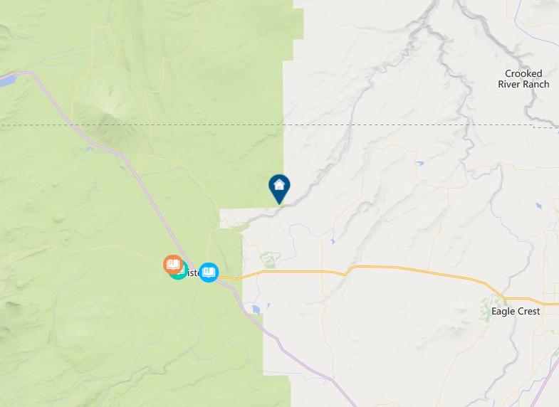
whychus canyon preserve trail map + rules of use

Whychus Canyon Preserve Rules:

—Dogs must be kept on physical leash AT ALL TIMES. Please clean up after your pet.

—Pedestrian travel only: no bike, horse, or motorized vehicle use.

—Stay on roads and trails and respect restrictions as posted.

—Removal or disturbance of plants, wildlife, and historical artifacts is prohibited.

—Catch and release fishing with barbless hooks is permitted subject to applicable state regulations.

—Commercial use and private events are prohibited.

—No hunting, motorized vehicles, camping, campfires, smoking, or unmanned aircraft use.

deschuteslandtrust.org

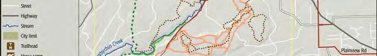
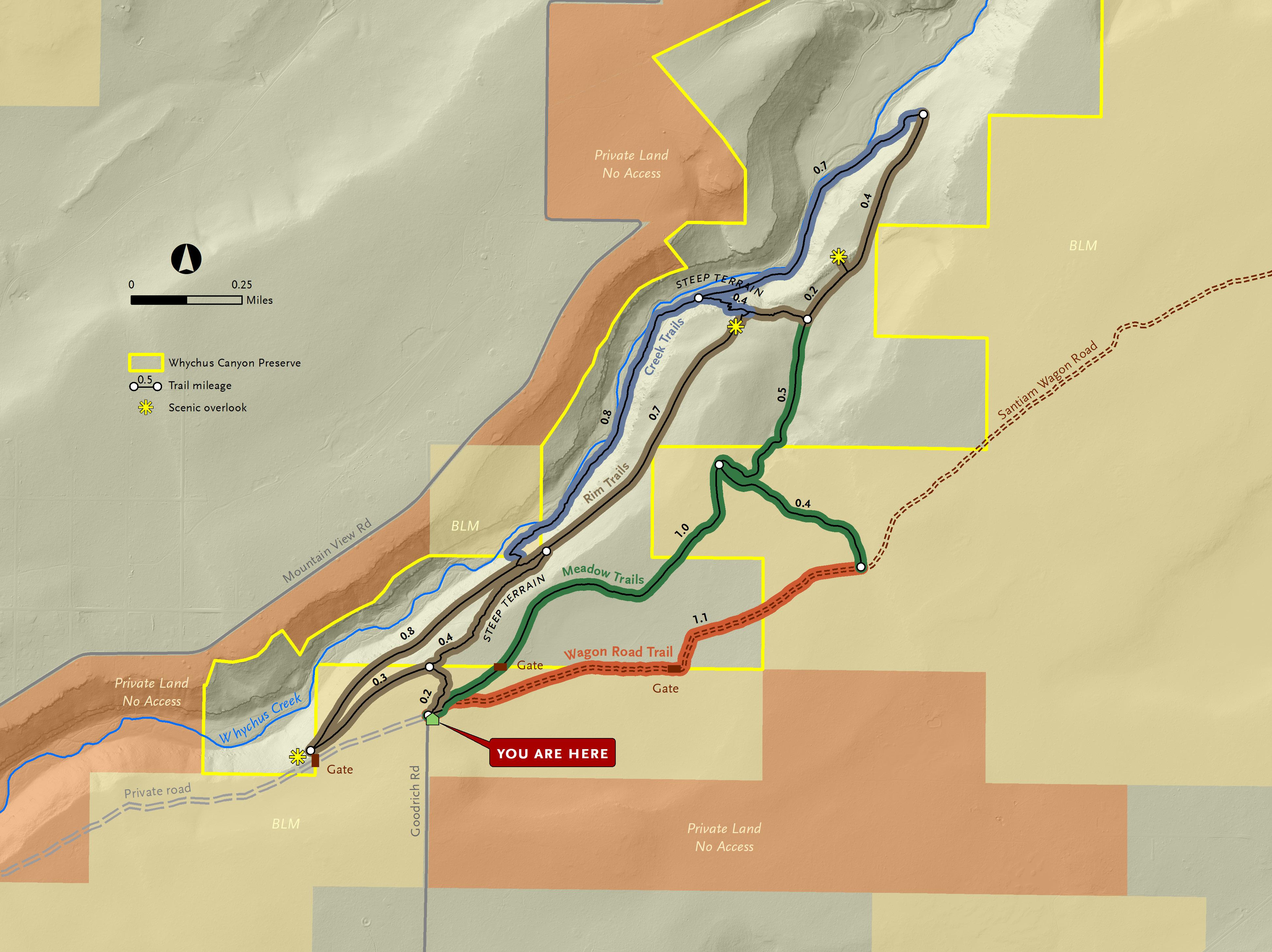
whychus canyon preserve suggested routes

Wagon Road and Meadow Loop: This route follows a portion of the historic Santiam Wagon Road. Interpretive signs along the way share the story of the Wagon Road east of the Cascades and the role it played in the settlement of Central Oregon. This fairly flat trail is lovely in the spring when desert wildflowers begin to bloom.

From the trailhead, follow signs to Wagon Road + Meadow Trails. When you see a Santiam Wagon Road interpretive sign on the right, veer off of the road and follow the dirt Wagon Road Trail. After 1.1 miles, you’ll reach a junction. Turn left and follow the trail through juniper and pine forest until you reach another junction after 0.4 miles. Turn left to continue on the Meadow Trail 1 mile back to the trailhead. Total Distance: 2.5 mile loop.

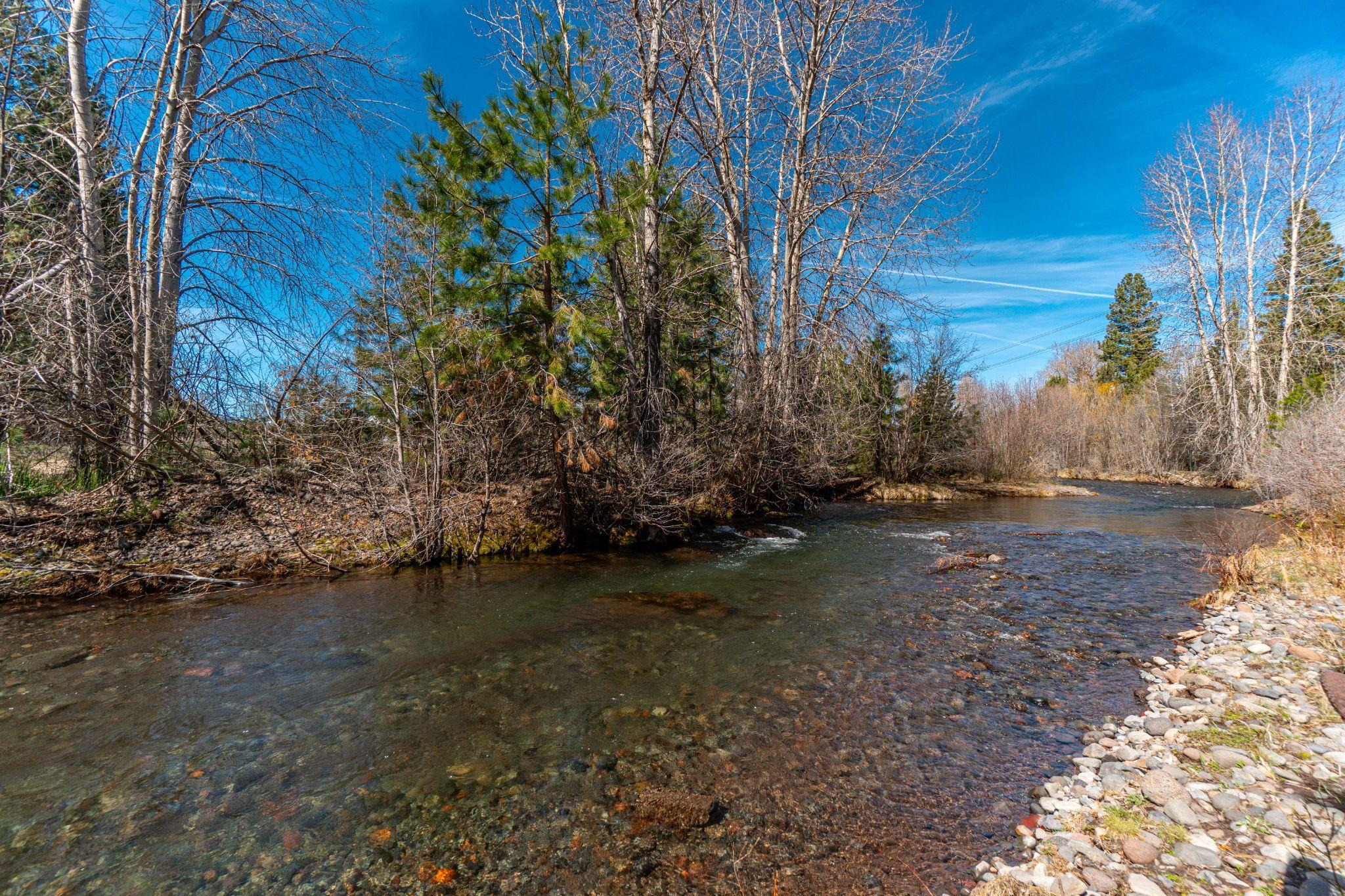
Long Canyon Route: Head down into the canyon to Whychus Creek, then stroll along the creek before heading back to the top of the canyon. This beautiful hike is challenging and involves steep trails with 300 feet of elevation gain/loss. Enjoy stunning displays of spring wildflowers, mountain views, and tranquil creekside breaks.

From the trailhead, follow signs to Rim + Creek Trails. At the first junction, turn left and walk .3 mile to a stone bench and overlook. The trail will begin to head down into the canyon for .8 miles. You’ll reach an intersection midway down the slope. Follow signs for the Creek Trail to reach the valley floor and walk downstream along Whychus Creek for 0.8 miles. At the next junction, continue straight through a sagebrush meadow for another 0.7 miles. The trail will then turn and begin to climb out of the canyon. Enjoy another scenic overlook before reaching the next junction at the top of the canyon. Follow signs for Meadow Trails and Trailhead for 1.5 miles back to the trailhead. Total Distance: 4.9 mile loop.

Mid Canyon Route: This route is for those looking for a quicker route that still dips into the Whychus Creek canyon without all the elevation gain/loss. Enjoy stunning displays of spring wildflowers and mountain views with 150 feet of elevation gain/loss.

From the trailhead, follow signs to Rim + Creek Trails. At the first junction, turn right and head down a steep route into the canyon for 0.4 miles. At the next junction, follow signs for the Rim Trail and turn right. After 0 7 miles along a rolling mid-canyon trail, you will reach a scenic overlook and bench with views into the northern portion of Whychus Canyon Preserve. Continue past the overlook to the next junction and turn right. After 0.2 miles you’ll reach another intersection. Turn left to add a quick 0.4 mile detour to another overlook. Or, turn right and follow signs for Meadow Trails and Trailhead for 1.5 miles back to the trailhead. Total Distance: 3.0 mile loop.

Georeferenced Map

Download a georeferenced map of Whychus Canyon Preserve to help with navigation. Scan the QR code to the right to download.

210 nw irving, suite 102 ∙ bend, oregon
deschuteslandtrust.org
97703 (541) 330-0017

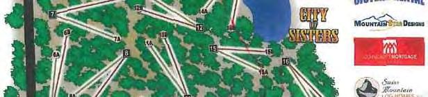
Mi ddle School Hi gh School Cros sro

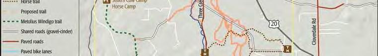
The Peterson Ridge Mountain Bike and Hiking Trail was designed as a ladder system. It consists of two linear trails, the PRT West and PRT East trails, with numbered connectors marked by junction posts that allow riders and hikers to design their own riding or hiking experience. We have included a loop option guide showing the distances from our Sisters Trailhead.

! ! ! ! ! ! ! k k k k k å å ! ! H T ! H T ! H T ! H T ! H T ! H T ! H T ! H T ! H T ! Elk R anch Lo op B Pe t ers on R i dge Hors e Trai l S i s t e r s £ 20 £ 20 U 242 U 126 " 1 6 T h r e e C r e e k s R d " 1 5 PoleCreekRd " 1 6 Bro oks Scanlon LoggingRd S E m S t Rd 2 20 PetersonMillRd 0161 0261 1514 1505 1505 1513 Edg ing ton Rd G Ed gi n gton Rd Wil dw i ng R d P e t e r s o n B urn Rd P n e S WagonWheel Livesay Rd 1612 H a r r i n g t o n L o o p Pe t ers on R i dge R d Parking at quarry F 880 4606 100 1608 Eurosport s Bike Shop Bl azi n Saddles Bi ke Shop Chamber of Comm erce Si st ers Ranger St at ion Three Creeks Brewing Co Q uarry Fi vePine Lodge Si st ers Park & Recreat i on WhychusCreek I nd i an Ford C r eek Fi ve pine conne ctor Tin Can A ll ey conne ctor Power li ne connect or Old St ump connect or Li tt l e Br idge conne ctor Eagl e R ock Pa ss Di tch Loop Bo neyard connect or Pipe li ne Summ er R ange conne ctor Runni ng El k conne ctor Doubl e Di tch connect or Turke y Hol l ow co nnecto r Tw i st & Shou t co nnecto r Haw k' s F li ght Te le grap h co nnecto r He ll o K i tt y co nnecto r Top R ung co nnecto r Dog Wal k co nnecto r La zy Z Loop Vi ew po int eM t o l i u s W i n d i g o Trail BarclayDr ¬
15
14
13
11A
9 ¬ 7 ¬ 8 ¬ 5 ¬ 6 ¬ 4 ¬ 3 ¬ 2 ¬ 1 ¬ 33 ¬ 32 ¬ 31 ¬ 30 ¬ 29 ¬ 28 ¬ 27 ¬ 26 ¬ 25 ¬ 24 ¬ 23 ¬ 21 ¬ 20 ¬ 19 ¬ 18 ¬ 16 ¬
¬
¬ 11 ¬ 22 ¬ 17 ¬
¬ 12 ¬ 10 ¬ 34 ¬ 15B
¬ 17A ¬ 15A
ads Whychus Cree k Ove rlo ok Parki ng Cree ks ide Pa rk/ Cam pground Spiri t Circl e Pla nt at ion F Bi ke Pa rk 24 2 G Eagl e R ock 2 Vi ew po int Pea k Vi ew Pe t ers on R i dge Ove rlo ok G Sis te rs Cow Cam p Hors e Cam p Rod eo Grounds Parki ng and Prim i t i ve Cam pi ng Jim ers on Loop P RT PRT East PRTWest PRT East PRTWest PRTEast PRTEast PRT W e st PRT Middle Whychus Foo t bri dge G Whychus Cree k Trai l i s a dif fi cult foot t rai l , clos ed t o all bik es and hors es Sis te rs Tie Tra il S H S South Tra il S H S to Tol l gat e Pat h Extension Parking for P RT and Scenic Bikeways Vi ll age Green Ci ty Park (3.2milesone-way) TRP W e s t 0 0 5 Miles E 4606 Power li ne connect or Old St ump connect or Li tt l e Br idge co nnecto r ¬ 9 ¬ 7 ¬ 8 ¬ 11 ¬ 12 ¬ 10 PRTWest PRT East ¬ 1 See Det ail A 11A Bo neyard connect or Pipe li ne Summ er Ra nge co nnecto r ¬ 15 ¬ 13 15A Di tch Loop PRT West P R T W e s t PRT O l d Trail See Det ail B Det ail A Det ail B Miles 0 1/8 Miles 0 1/8 Mo u n t a in b ike/p ed es tri an trail Easi est (P RT O l d Trai l ) Easy Mode rat e Di f fi cul t Hor se t rai l Me tol ius Wi ndigo trail Whychus Creek trail Proposed tra il Junct i on num ber k Vi ew point ! Re stroom ! Infor mat i on ! Bike sh op ! Hor se c amp ! H T Trai lhead ! Ca mpground Sha red road ( gravel- cinder ) Uni mproved road Road Hi ghway Ci ty of Sis ters
Peterson Ridge Loop Options from Village Green Parking Junction 2-3 5-6 7-8 9-10 11-12 13-14 15-16 17-18 19-20 21-22 23-24 25-26 26-27 29-28 34 Connector Name Dog Crossing Tin Can Alley Powerline Old Stump Little Bridge Boneyard Summer Range Running Elk Double Ditch Turkey Hollow Twist & Shout Telegraph Hello Kitty Top Rung Merger of PRT-East / West Loop Distance (miles) 1.4 2.8 3.3 3.8 4.1 5.6 6.8 7.8 10.3 12.3 14.3 14.8 16.8 18.8 20.8
georeferenced
Peterson Ridge Trail System
Link to
PDF. See Sisterstrails.com for details.
Description of Peterson Ridge Hiking and Biking Trail (PRT)
SCHOOLS
First American Title Insurance Company, and the operating divisions thereof, make no express or implied warranty respecting the information presented and assume no responsibility for errors or omissions. First
School Report
DEMOGRAPHICS
First American Title Insurance Company, and the operating divisions thereof, make no express or implied warranty respecting the information presented and assume no responsibility for errors or omissions. First
Demographics
Issuu converts static files into: digital portfolios, online yearbooks, online catalogs, digital photo albums and more. Sign up and create your flipbook.