
PORTFOLIO "Seeking my cityscape" Xinyu Su suxinyu435@gmail.com +44 0759718367


Kilbourne/Kelebourne is the earliest name for the Westbourne River and the origin of the name KilburnKilburn is the small river delta formed by the Westbourne River flowing out of Hampstead Heath. From the 19th century onwards the river was heavily polluted by the toilet revolution and high levels of pollution from industrial production. It became an essential north-south sewer in the Joseph Bazalgette scheme and was converted into an underground pipe.

However, the frequency of extreme weather events has increased under the influence of climate change. Short periods of heavy rain can lead to the city's surface being flooded during the summer months. At the same time, combined sewer systems can no longer handle both sewage and rainwater during storms, which can lead to pollution and waste of natural water resources.


On the initiative of environmental groups and the impact of frequent urban flooding. The government has begun upgrading the sewerage system to separate stormwater and sewage lines. The project is designed to benefit from this upgrade.
The project is designed to benefit from a separate sewer
system. The stormwater pipes from Kilburn Grange Park to Kilburn Park Road will be daylighted. It drains quickly in the rainy season through the flood channel. It becomes a recreational area for residents along the route, leading to Kilburn High Road's economic prosperityad. Flood ponds and pocket gardens will be created to connect to the river, improve stormwater treatment and purification, deal with street extreme weather events, and improve the living environment.

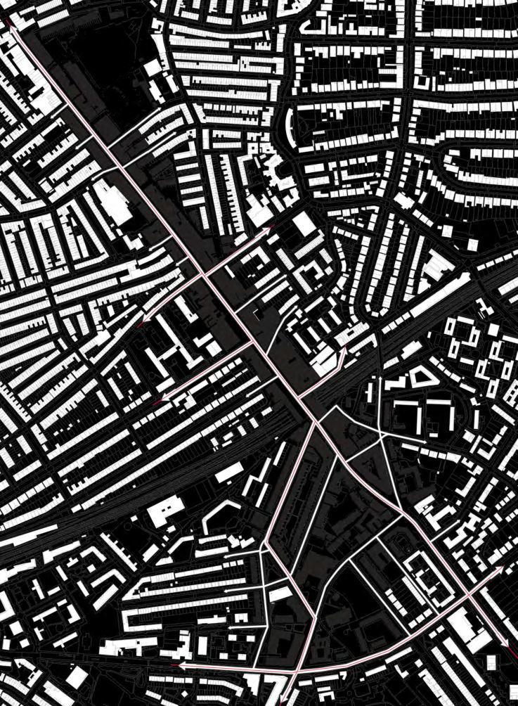
River Westbourne Tributaries

River Westbourne
Loop Line
Site Visit Tracks
Public Traffic Tracks
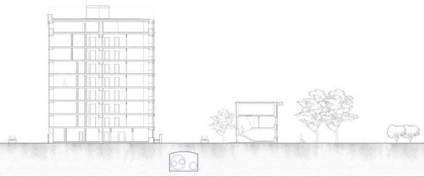
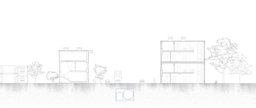
Section B-B'

"London falling: violence, feuds and fear scar the capital's heart"
"The rivalry has been reported to be a typical 'postcode war'"
"Typical of brutalist 60's designs of public housing in the United Kingdom" Who They Was"
"Defects in South Kilburn block results in all occupiers forced to move home
"Drugs and deadly weapons found hidden in bushes in South Kilburn"
"The River Westbourne flood defences, the tale of two boroughs"
Queen'sPark
Kilburn derives its origin from the kelebourne stream which eventually joins Westbourne, through which the Roman road known as Watling Street crosses.
Kilburn belonged to church land at the time. The part of Kilburn in the parish of Willesden belonged to the manors of Bonds, Brondesbury and Mapesbury. The monastery was a stopover for pilgrims on their way to the shrine of St Albans and later to Willesden.

Edgware Road extends northwards and a number of pubs have emerged in Kilburn. However, because seasonal agricultural areas do not encourage settlement, Kilburn has very few houses. A spring of medicinal value (containing iron) at Abbey Fields made Kilburn famous as an 18th century retreat. Kilburn became a notorious dueling ground in the late 18th and early 19th centuries
In 1815, records show a developer called Thomas Buckley built seven large houses along the west side of the Edgware Road, just north of Willesden Lane. By 1839 most of Kilburn's new buildings were 'beautiful villas and houses' aimed at the new middle-class professionals. In 1857, the builder James Bailey began to develop the neighbourhood. From 1861, Bailey built a series of roads and houses around a triangular space called Cambridge Gardens.
In 1915 the bakerloo was extended northwards. Kilburn Park station became the first underground railway in Kilburn, described by Charles Dicken as "a new district at the end of Edgware Road". The building was purchased by the RSPCA in 1931 for the Animal War Memorial Dispensary as a tribute to the numerous horses, dogs, donkeys, pigeons and many other types of animals used by the army in WWI and who gave their lives for their human owners. After WW II, taller flat blocks appeared in Kilburn and there was an influx of Irish immigrants.
The Kilburn High Road Community Improvement Area will be a community partnership with Camden and Brent Council. It will bring together stakeholders in the area to establish a community-led approach to regenerating the area.
Because Kilburn High Road runs along the boundaries of three boroughs, this involves a number of demarcation issues and, in general, there is a disorganisation and lack of maintenance of the public facilities here.
Aging amenities: Over time, public benches, squares, and pavements can deteriorate due to wear and tear, and replacing or repairing them can be costly.
High levels of vandalism: Sometimes public facilities are deliberately damaged, which can lead to disrepair if not dealt with in a timely manner.
Low community involvement: in areas with low levels of community involvement or awareness, public spaces may not receive the attention they need.

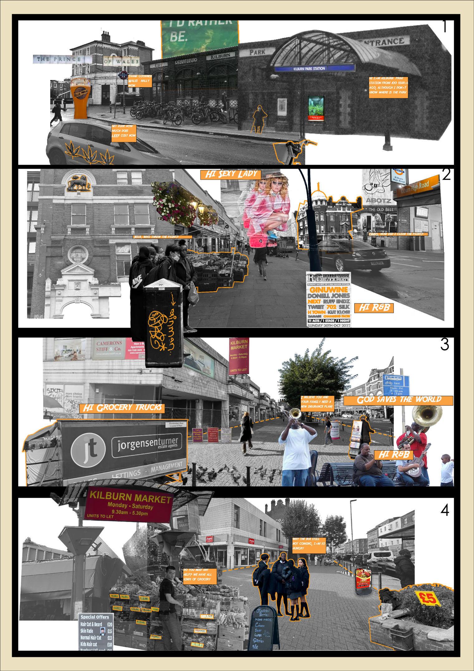
Ownership issues: sometimes it may be unclear who is responsible for maintenance - whether it is the local council, a private entity or a community organisation.
Cambridge Garden
0.4 ha
Public seating: 5
Children's facilities: 0
London Plane Trees: 11
Brich Trees: 2
Lime Trees: 3
Since it was first built in the mid-19th century, South Kilburn was notorious for its flood risk to housing, which made the area unpopular, difficult to sell new homes and concentrated poor people there. In the post-World War II wave of urban renewal, designers made use of the park's green spaces and built comprehensive flood protection facilities to accompany them. Kilburn has been praised for its excellent social and health infrastructure.
Brent Council denied the existence of the Westbourne river and downgraded it to a sewer in order to accommodate regional development.“ From 2010, the policy of total removal of publicly owned flood defences in the South Kilburn growth area and its green public green space and the resulting increasing flood risk was manufactured, leading to an agreement with Westminster. ”

On 12 July 2021 North West London received as much rainfall as it does in a day-to-day month. the Westbourne River function channel was unable to discharge rainwater quickly enough. Rainwater overflows from the pipes and flows to south Kilburn.
Westbourne River Tributaries
Westbourne River
Loop Line
Brent Policy boundaries
Sewer flooding records by Thame Water
Low population density
Middle population density
High population density
050100 m

The River Westbourne, one of the major tributaries of the north bank of the Thames, originates from a pond on the south-west side of hampstead Heath. It flows through Kilburn, Maida Vale, Paddington, Hyde Park, Knightsbridge and ultimately nto the Thames below Chelsea Bridges.The geology of the river deposits near Chelsea Hospital is associated with it.
The original name of Westbourne may have been Cowlburne or Kelebourne, which is related to the tributary that joins at presentday South Kilburn, and the place name Kilburn is also related to this river.
In the early 19th century, London built Kilburn Bridges on the River Westbourne by extending Edgware road northwards from the original Roman road - Watling Street. This was the basis for the present Kilburn High Road. As it flowed through the ecclesiastical land south of Kilburn, the river was lined with dairy farms which supplied milk to the Royal Family. The Grand Junction was completed in the 1830s and River Westbourne was forced to turn into an underground tunnel through the canal at Maida Vale, with pumping stations on both sides.

When it came to Bayswater, the River Westbourne was an important source of drinking water for livestock. In its heyday, there were as many as 23 stables in the area.


The following series of sections are extrapolated from sewer explorers and relevant references. North of Hyde Park, Westbourne's original river channel becomes part of the Ranelagh CSO. From the time it entered Hyde Park, the original river was part of the Ranelagh Storm Relief, which was primarily responsible for storm water drainage. At the same time Tyburn Brook - its tributary - has a separate pipeline and runs parallel to the RSR.


The River Westbourne, rose from numerous springs and headwater streams on the western edge of Hampstead Heath. With the development in this area, by the turn of the twentieth century the open watercourses, springs and ponds had mostly disappeared from the surface and were either placed into culverts or infilled. Much of Highgate wood is covered by London Clay and young Claygate. The soil is alternately shallow with a sequence of silt and fine sand grains.
 Section A: Kilburn High Road
Section B: Kilburn Park Road
Section C: Kilburn Park Road
Section D: Shirland Road
North West Storm Relief
Tributaries
Tributaries
Section A: Kilburn High Road
Section B: Kilburn Park Road
Section C: Kilburn Park Road
Section D: Shirland Road
North West Storm Relief
Tributaries
Tributaries
SEWER SYSTEM AND MISCONNECTION
London City Flood Simulation and Misconnection Map


Separate Sewers
Combine Sewers
River Flood
Surface Flood
V
Westbourne River (Ranelagh CSO)
Northwest Storm Relief
Foul Sewer
Combined Sewer
Main Combined Sewer
Manhole Cover
Vent
Tunnel
Main Design Area
Public Green
Precipitation


Rainfall for the summer period across the whole of the UK was low, with less than two-thirds recorded compared to the 1991-2020 average. The extremes in the UK weather will not only include storms and floods, but also heatwaves and periods of dry. During the past decade, winter storms and floods, as well as heat and drought, seem to have become the new normal.
This is because South Kilburn and Maida Vale to the south are the first low-lying areas after Westbourne flows out of Hampstead Heath. Maida Vale is managed by Westminster Council and a large flood storage facility is built on the south west side of Maida Vale. Rainwater can only flow to South Kilburn, which lacks flood protection infrastructure South Kilburn has become a sinking sink.
(Data from UK DEFRA)
Misconnections are where your property’s wastewater pipes are incorrectly connected into your rainwater downpipes. If your property is misconnected you may be polluting your local river. Plumbing misconnections are usually easy to fix and are the responsibility of the property owner. ( Data from Thames Water Propety Search
Misconnection: More shower and more appliances, and we put things down the toilet that can't be flushed, causing clogs. There are more and more hard surfaces, so when it rains (and with climate change, it is raining more and more), more of it goes down the drain - which is close to or at its capacity. Storm overflows are also more frequent.
Right Connection: Rainwater tanks have been added to other networks, actively managed and rehabilitated, and the capacity of sewage treatment plants has been increased. Numerous automatic drainage systems have been added to streets and public spaces, 'greening the grey areas' and keeping stormwater out of combined sewers. Storm water overflows rarely overflow.

Daylighting and deculverting are related processes with the shared objective of improving urban watercourses. Deculverting is a crucial component of daylighting, focusing on removing artificial structures that confine a river. Daylighting, on the other hand, is a more comprehensive approach that includes deculverting and other restoration efforts to improve the ecological health, aesthetics, and social benefits of the watercourse and its surrounding landscape.

While deculverting is an essential step in daylighting, it does not encompass the full scope of a daylighting project. Daylighting goes beyond deculverting by addressing additional aspects of river restoration, such as bank stabilization, habitat creation, and landscape improvements.

Hard Edge: The main purpose is to ensure the rapid passage of floodwaters and to maintain the safety of buildings on both sides and the stability of river banks.
Soft Edge: By restoring natural river features and vegetation daylighting projects create a more complex and diverse habitat structure. This complexity provides a variety of niches for different species to occupy, fostering greater biodiversity and ecological resilience. While retaining the original large mature and beautiful trees, gully terrain is created to both enrich habitat and provide space for flooding.
Tunnel information:
Max flow rate 10m³/s
Highest level : 2m


Maximum daily rainfall : 93.5mm

Original Pipeline build time 1830s
Set aside water caves to provide shelter for aquatic life. It is also possible to introduce snails and other crawling creatures to clean the water and attract birds.
The different topographic elevation differences between the left and right sides favour water drainage and provide more space for water storage.


Diverse flow structures support habitat system restoration.
The wide channel facilitates rapid flooding and provides wide views.
Infiltration: Infiltration is the process of allowing water to permeate through the soil. As water infiltrates, it is filtered through soil particles, which can remove pollutants such as sediment, heavy metals, and hydrocarbons.
Sedimentation: Sedimentation is the process of allowing particles in the water to settle out due to gravity. SuDS components like ponds and wetlands slow down the flow of water, allowing particles to settle and be trapped in the system. This helps remove pollutants such as sediment and suspended solids from the water.
Biological Treatment: These systems use plants to help remove pollutants from the water. Plants can absorb nutrients like nitrogen and phosphorus and can also help break down or transform pollutants through a process called phytoremediation. Additionally, bacteria and other microorganisms living in the root zones of plants can break down pollutants, further contributing to water purification.

Adsorption: Adsorption is the process by which pollutants adhere to the surfaces of materials, such as soil particles, organic matter, or filter media . This can help to remove pollutants like heavy metals and hydrocarbons from the water.


The harvesting of underground rivers involves the removal of culverts, underground pipes or other artificial structures used to channel the river beneath the road, and the subsequent restoration of the natural river to the surface. This process can bring many environmental, social and economic benefits to the surrounding area. The visual attractiveness of the landscape can be significantly improved by providing light to underground road rivers. The restored river can become a focal point for the community, providing a more aesthetically pleasing and pleasant environment. The introduction of water features and natural elements can also create more attractive and inviting public spaces.
By restoring the natural flow of the river, daylighting can significantly improve the health and diversity of the local ecosystem. This process can lead to the re-establishment of aquatic habitats, supporting the recovery of a variety of fish, invertebrates and plant life. In addition, daylighting can improve water quality by reducing pollutants and sediment, resulting in cleaner, healthier water for communities and the environment. By restoring the natural ability of rivers to absorb and transport stormwater runoff harvesting light to underground rivers can reduce flood risk. By restoring rivers to their natural state, their ability to slow and store water during heavy rainfall events can be improved, thereby reducing the risk of flooding in surrounding areas.
The original pipe is lowered through the centre of the road and connected to the sewer on both sides. Wide pipes and high mixing volumes make them prone to clogging.


The government's intention is to replace the old mixed pipes with separate sewers, which, despite their smaller diameter, do not change the flow of rainwater, but have a larger capacity. Easier management of storm water and sewage separately.

When the rainwater pipes are opened and the river regains its visibility, it has more space to hold flood water. At the same time, the existing pipes below are retained, increasing the river's capacity to handle water in the event of extreme flooding.

It not only offers a solution to control flooding but also provides ecological benefits by creating temporary wetlands that can host a variety of plant and animal species. This enriches the ecosystem and further strengthens the relationship between the built environment and the natural world.
1. Purify Pond
Objective: To act as a natural filter for the river, trapping pollutants and sediments.
Design Elements: Native aquatic plants/Shallow zones for sedimentation/Aeration systems
Benefits: Improved water quality/ Enhanced biodiversity/ Aesthetic value
2. Canal System
Objective: To manage water flow and reduce the risk of flooding.
Design Elements: Controlled locks and gates/ Reinforced walls/ Spillways
Benefits: Efficient water management/ Flood control/ Opportunities for water transport
3. Different Types of Banks
Objective: To stabilize the riverbanks, reduce erosion, and create habitats.
Types of Banks:
Riprap Banks: Stones or concrete blocks
Vegetated Banks: Native plants and shrubs
Engineered Banks: Geotextiles and retaining walls


Benefits: Erosion control/Wildlife habitats/Aesthetic diversity
4. Accessablity
Objective: To provide safe and easy access to the river for both humans and wildlife.
Design Elements: Non-slip material/ Gentle slopes/ Handrails and signage
Benefits: Improved accessibility/ Safety features/ Encourages interaction with the river
5. Flood Basin
Objective: To temporarily store excess water during heavy rainfall or rapid snowmelt, reducing the risk of flooding in downstream areas.
Design Elements: Contoured land to direct water flow/ Vegetation to absorb water and stabilize soil/ Controlled outlets for gradual release


Benefits: Effective flood control/ Groundwater recharge/ Creation of seasonal wetlands beneficial for local fauna
6. Additional Features
Objective: To enhance the overall usability and sustainability of the river.
Features: Observation decks/ Walking and cycling paths/ Fishing platforms/ Docks
Benefits: Recreational opportunities/ Public engagement/ Ecological education


Large Movement: cut off a portion of the road for a green space/ water area while maintaining access to all buildings. Also restricts speed and parking on Kilburn High Road to ensure efficient access and pedestrian safety on both lanes.
Internal Movement: the north-south movement is coherent and connected to the movement of the residential area, increasing the accessibility of the area. The cut-off road is internalised as a park movement.


Vegetation and Green: All mature tall trees within the design area have been retained (including changes to the topography) and proposals are intentionally protective of these trees.
Structures: Integrity and accessibility of movement lines. At the same time increase the visual effect and enrich the field of view
Primary Street
Secondary Street
Zoning
River
Underground River Tunnel
Limited Street
Normal Street
Limited / No Parking Street
New Building (extension)
Primary Pedestrian Only
Pedestrian Only
Roof Link
Rowing Line

Tertiary Street - one way
Key Area
Mature Tree (68)
New Tree (17)
Shrub & Shallow Plants (49)
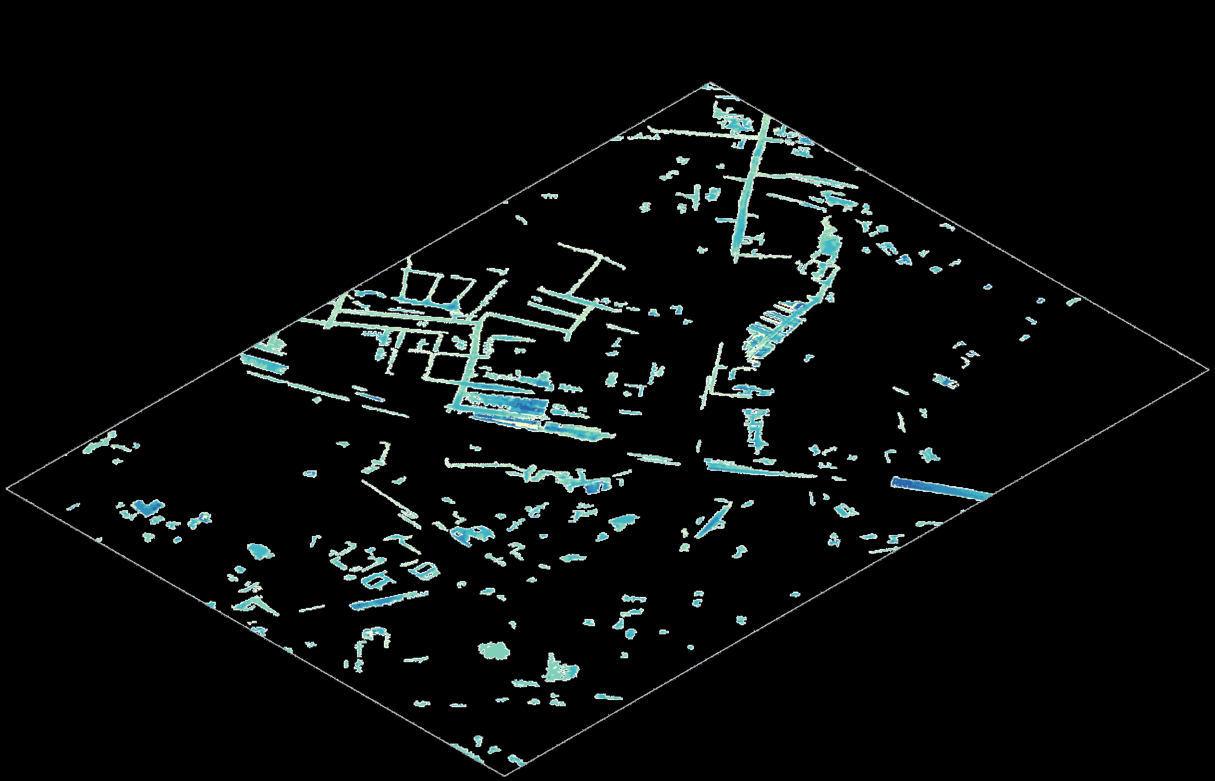
The section line is perpendicular to the river channel. In Parts A, B, C and D, lines are placed at 20 metre intervals along the channel. In Parts E and F, lines were placed at 40 metre intervals along the river channel.
The total number of sections is 56 and the length is 1.6 km. In each following part of the detail, key sections will be listed in enlargement.
This page is not in scale because the view changes.


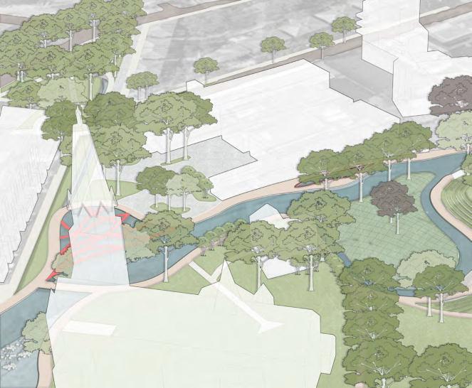
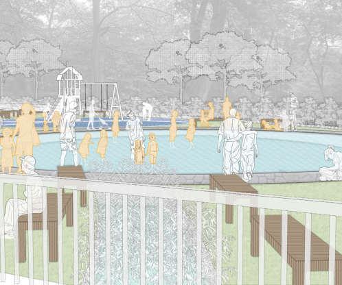
Grange Park serves as the beginning of the river's return to the daylight, which will first pass through a sedimentation and purification basin and flow out slowly. At the same time the excavated terrace will serve as a temporary saving in times of extreme flooding. The stepped terrace allows people to get closer to the river and softens the 6m height difference, making it a great place to enjoy the sunshine on a nice summer's day. The cross trail on the top increases the level and interest of the space. However, as the water purification is not completed, it is forbidden to go into the water.

 River Tunnel Sunshine Terrace


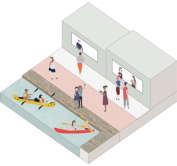
After the river flows out of Kilburn Grange Park it briefly exists in a hard banked pattern of canals for the purpose of rapid drainage in the event of flooding. Also due to the depth of the river at this point, the banks are too close to the buildings on either side for natural riparian restoration.
Beyond King's Gate Garden, the depth of the river gradually becomes shallower and opens up, where a two-tiered walkway is created to ensure proper access for residents on both sides. After a long process of purification, this area allows people to get close to the water. The planted pools on both sides of the river enrich the view, guide the flow of water, increase the speed of the water and provide a basis for boating.

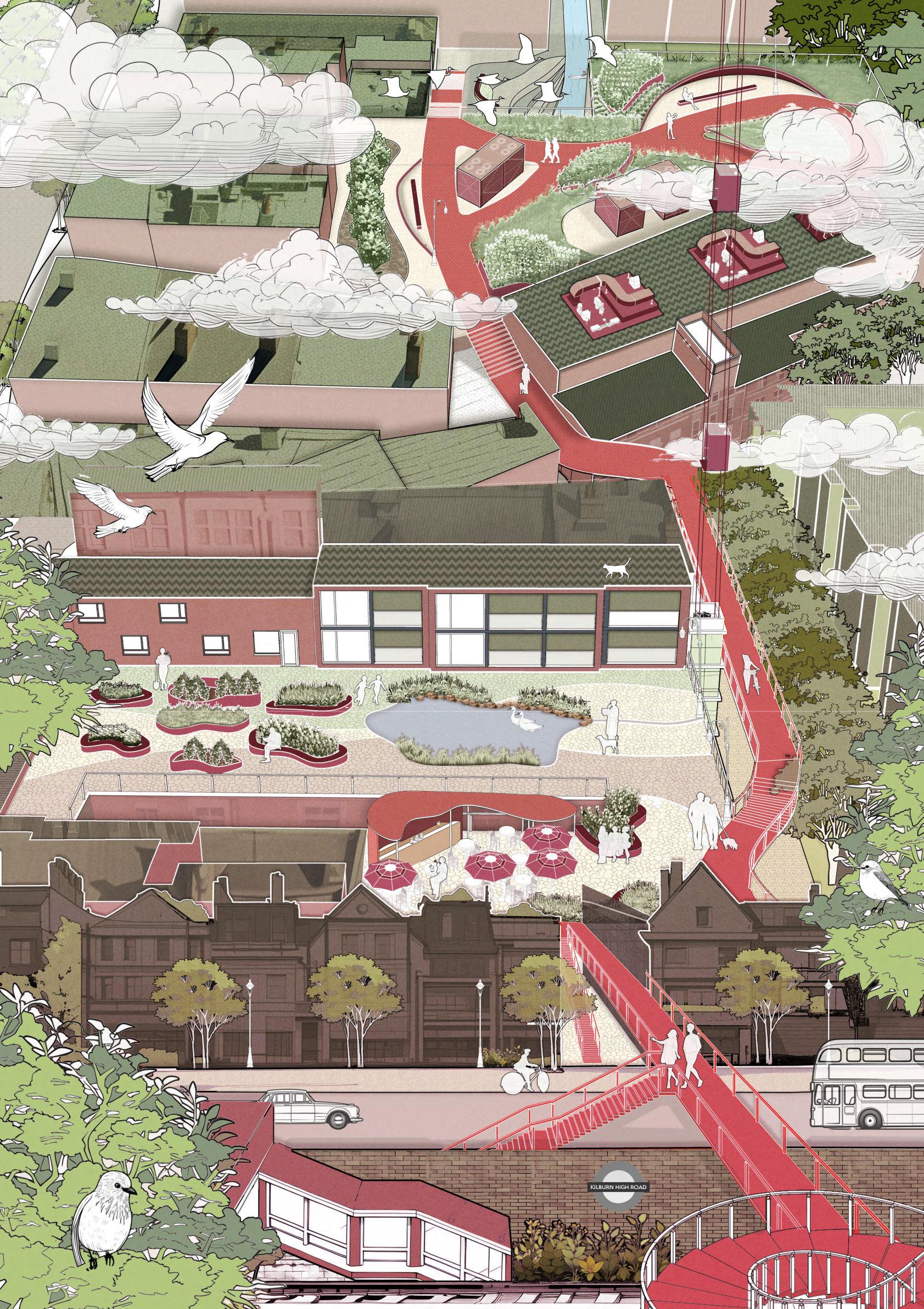


The spiral staircase becomes the another starting point for the trail across the railway. Meanwhile, the river returns to the surface on the back side of the Irish Pub after finishing its underground section. And the water pressure is used to build a fountain.
The terrace provides an opportunity for people to get close to the water while providing space for waterfowl. Bridges across the river provide a wealth of movement. During the rainy season, large areas of water provide temporary flood storage.

As the river crosses Kilburn High Road to the west, it becomes a tunnel. At the same time the road surface is raised to limit vehicle speeds and ensure continuity of the trail and pedestrian safety. Form a small gathering spot in front of the Marriott Hotel


When flooding occurs, bridges across rivers are temporarily submerged. At the same time, due to the low level of the clarifier, a portion of the floodwaters will be temporarily saved. Of course, the curved channel in front of the church would also provide temporary flood savings. Buried overflow pipes ensure the safety of aboveground buildings

At Kilburn Park, there will be undercutting to suit the terrain. Here the riverbank will have two levels. One level will be parallel to the river and the other level will be parallel to the building ground. At the same time a flood basin will be created in the former triangular garden, which will be connected to the roof of the sports centre by a ramp. Here there is more water space.


The steps to the left follow the terrain while allowing the river to form a cushion here, matching the scene with church. The island in the centre will run independently to provide habitat for river related creatures.


The purification pond at the front of the school would be a perfect place to practice education. The cascading filtration system will show students how the water filtration system works. At the same time, different pools will be rotated with different plants to ensure that the filtration runs at different times. The lush also provides space for birds to survive.


Highgate Woods is one of London's many ancient woodlands, located in north London and crossed by the Capital Ring Road. Covering 28 hectares, Highgate Woods is home to more than 950 species and is of great ecological conservation value. A standard ancient oak wood accompanied by boxwoods includes more than 50 species of trees and shrubs.
Around the playing field and in the areas where there is much dead wood scattered about, the soil is heavily trampled because of frequent visits, changing the soil's infiltration rate. The rainwater cannot infiltrate into the ground when heavy rains come, and surface runoff is formed. This leads to waterlogging and mire formation in low-lying areas. At the same time, the topsoil, which is washed away by surface runoff, takes away large amounts of nutrients, the density between soil molecules becomes less, and plants gradually fail to grow.
Many visitors flock to the playing fields and move uninhibitedly through the woods. The cafes became a busy places, unable even to cope with the many customers on weekends. Under the influence of the pandemic, family-based visitors became the primary users.
by building on the soil improvements in the project.
The entire route will be linked to the three themes of managing nature, relaxing in nature, and surviving.
The most important part of the route is the central area, where the playground is moved to the centre while the café area is expanded to make the family experience more complete. The former playground has been transformed into an educational centre where families can learn about the conservation work of highgate wood and nature. At the highest point of the site, a camping site will be created where children can learn basic survival skills in the wilderness.


One of london's many ancient woodlands, highgate wood dates back to the first century ad. It also provided london with raw materials and the british navy with shipbuilding materials in an era when wood was an important raw material. Because of the huge central sports ground, today it is one of north london's most popular public woodlands. With over ten schools within a kilometre of highgate wood, it is also an important educational and extra-curricular venue.
As an ancient Oak standard with Hornbeam coppice, It has a wide variety of ground cover, but the main part is still natural woodland surface. Look out for several mature wild serrvice trees; these are considered to be good indicators of the wood's ancient origin.
The decline of the oaks and the increase in the area of holly are distinctive features of the old woodland, which also marks the decline of the woodland as the holly continues to occupy the environment of the newly planted trees. City of London has also planted a number of non-woodland native plants in highgate wood to enrich the woodland flora and enrich the visual aspect of the landscape.


Holly Group Oak Hornbeam Beech Birch
Conifer Hawthorn Willow AlderPlanted Oak
Wild Service Tree Big Old Beech
1988
2021
Bramble
Ivy
Grass
Fallen tree (still live)
Fallen tree (dead) &logs
Trees regeneration
Unofficial Road
Nature Woodland
Shrub

Sportground


Playground
150m0m75m
BrambleIvy Grass Nature Woodland Trees Regeneration Fallen Tree Still Live Fallen Tree Dead Shrub


The source of visitors to Highgate Wood is mainly residents of the N10 postcode area. The increase in woodland issues has been significantly linked to population growth and increased visitation. Typically visitors come to highgate wood for the purpose of travelling through the woodland and the café in the centre, which also includes sport ground. This leads to this area being the most problematic.


Sunny weekend afternoons are the most popular time at highgate wood and this is usually a family event. The children play in the playground, the adults enjoy the sunshine in the café, or all play sports in the open space!
Protecting the Bluebells Wooden Fence
Preventing trampling by people and dogs and blocking unofficial roads.
Protecting the Bluebells
Wooden Trail
Ensuring space for bluebells to grow while increasing the human experience.
Soil Improvement
The soil is clearly stratified because of compaction. Lack of organic matter, light in colour.
10 Year
Significant role of plant roots, increased soil nitrogen content and soil loosening.

Protecting Woodland Willow Fence
Restoration of poorly closed woodland through natural restoration.


Disabled Toilet
Car Park
Disabled Car Park
Cafe Playground Education Centre
Camping Field Sportground
Recommended Routes Bluebell Protection Range Woodland Protection Range
Woodland Lawn Wooden trail Building Water System


Accessibility

All gates are accessible to wheelchaiss, disabled infrastructure are near the Cafe and Education Centre.


Is from the north side of the café: there is a small wooden horse for young children and a climbing device for teenagers further on. Tall hornbeam trees provide shade if you don't like strong sunlight. The addition of disabled parking spaces on the outside completes the infrastructure and accessibility of the site, although there are not always cars parked here.


View
Is in the north-west corner of the café. From here you can see the middle of the playfield through the open floor-to-ceiling windows. You will see children swinging on the swings. As well as a climbing net for children aged 6+, this might be a way for them to get in touch with the tall trees. Of course, this is also the closest entrance to the playfield from the Café.
Iis the new floor-to-ceiling windows and outdoor area from the café. When the children and their father go on a camping trip or the children and their mother visit the education centre, you can come and have a little seat here and order a coffee to enjoy the afternoon sun.

Sitting on the east side of the cafe on the outdoor gallery, you can see the playground and pool opposite, and you can let the kids play in the playground while you sit in the cafe and watch them have a great time. On rainy days, the water in the pool will slowly rise. This is a perfect rainy day laze activity.
Standing at the connection of the drain and the sportground, you can see the pool and the playground on the right. In summer you can see children playing in the pool; in autumn you can see the leaves floating on the water. When the children are not yet out of school, of course you can also sit by the pool and enjoy the sunshine, with your coffee and a book in hand. Enjoy the peace and quiet of the woods and listen to the birds quietly.
The terrace garden in front of the café is a partition before the sportsground, no one wants to be hit by a football in the café. Also this is the sunniest spot in the whole woodland where you can enjoy your lunch and watch the stream flow by. The curved structure and the planted pools are also effective in intercepting runoff. The arc also interrupts the original line of movement, dispersing the active line and alleviating the condition of the soil tramp.


"City memory" is a concept that relates to the shared history, experiences, and collective narrative of a city's inhabitants. It can be seen as an essential part of a city's identity, reflecting its history, culture, and development over time. In Beijing, a significant part of the city's memory is embedded in its architectural and urban heritage, such as the Beijing City Wall Ruins. This area is an important part of the transformation of Beijing's old city and can reflect the past development of the city, as well as the development at present and in the future. It represents a threshold between the old city and the outside world, bearing witness to the city's rich history and its continued evolution. The renovation and preservation of these landmarks is a significant aspect of maintaining the city's memory and cultural identity

Relocating from the old town in Beijing, often due to urban redevelopment and forced relocation, can have a substantial impact on the people who move. The process is typically complex and can be stressful, involving land expropriation, compensation negotiations, and forced movement. For many people, their connection to their neighborhood is deep, involving social networks and a sense of place. The forced relocation can disrupt these people-place interactions and lead to a variety of responses, including resistance, negotiation, and
adaptation. Some residents may see the redevelopment as an opportunity to improve their living conditions, while others may feel a profound loss due to being uprooted from their community. The impact is not only physical, but also social, economic, and psychological. The needs and expectations of the relocatees vary, and their diverse experiences and perceptions should be carefully considered in the redevelopment process
The old city bears a lot of people's memories. With the development of the city, people in the old city move to a new city without memory, and there are less and less communication activities. At the same time, the young people who come to the big city to wander are also far away from the city memory. I design urban furniture through the architectural outline of the old city of Beijing, in order to awaken people's urban and cultural memory. Inspired by Beijing's traditional architecture, Siheyuan, through wave shape to realizes various functions of community garden, rest and city memory.
Tiantongyuan, the largest community in China, is located in Dongxiaokou Town, Changping District, Beijing. It belongs to the junction of urban and rural areas, and is the largest economic and applicable housing cluster area in Beijing The community covers an area of 480000 square meters, with a planning area of 420000 square meters, including 350000 square meters of economic and practical houses. With the development of the times, Tiantongyuan, as the first building complex in the 21st century, has a lot of residential problems.


Tiantongyuan -The


Beijing China Changping Dongxiaokou Town Tiantongyuan
As the gathering area of affordable housing, Tiantongyuan is the first choice for the evacuees in the old city of Beijing and the residence of the staff coming to Beijing.
The residential structure of Tiantongyuan mainly divided into three types: working, going to school and retiring.


Through
research, the following data are obtained


Small backrest and plant belt are set on the platform to increase the playability of the platform.

The planting area can be used by nearby residents to form a small community garden.
The platform serves as a place for cricket fighting and other living habits, as well as a place for storage.
Pool provides a place for residents' fish farming habits, and also provides science popularization.

Add two swings to increase activity area for children.


Wood structure is set in the middle to form a gathering area and meet the needs of keeping bird.


The left wooden wave structure provides seats, forming a relatively closed space. Set up seats and bicycle parking at the connection with parking lot to isolate parking lot and garden.
The height of the wooden wave structure on the right side is low, increasing the playability of children.


When it comes to hot springs in Kunming, there is no better place than Anning. The An Ning Hot Spring, known as Biyu Spring in ancient times, is located on the side of a mountain and is as famous as the "First Soup in the World". Jinfang Street is located in the southeast of Anning City, one of the city's central districts, 30 kilometres from Kunming, which gives it a good geographical and locational advantage. The village of Dian Tho is part of the Siyi Village Committee of the Jinfang Street Office, which is a semi-mountainous area.
“Caishichang” is what “market” means in Chinese. Located on the border between Anning City and the countryside, the Anning Market is the first place for the integration of the countryside and the city, and it is in urgent need of renovation and upgrading in the face of foreign visitors. We explored the relationship between space and people in the vegetable market. It means an architectural space, an integreated act and a daily routine. When the two groups communicate, we are more looking forward to a “balanced collision”, where life, production, growth integrated in a presupposed space and time.

L means living E means ecological P means production, the three words come from the government’s policy. This is a group project. was responsible for the
research in the early stage, the design of the second floor of the project and completed some renderings. Because this market is located at the junction of the city and the countryside, we should not only change the mess of the original market, but also increase the functions of relax, village tourism and ecological circulation. In order to make the design more realistic, my partner and I went to inspect many markets to let us understand that Chinese food market is actually very interesting. At the same time, the color and style of the whole project refer to the color of pop art, some of the details are very cute


The prosperity in the East and West Market of Chang’an


In order to design the project perfectly, we have conducted market research. The research consists of two parts, a total of 407 online valid questionnaires and 43 offline one-on-one interview survey copies. People interviewed in the research are residents, farmers, and visitors. Research Results

Average Precipitation (mm)
More precipitation in summer and autumn, less precipitation in winter and spring.


The project is located at the junction of Jinfang Village and Anning City, Kunming City, Yunnan Province, China. There are seven medium-sized markets in the region.

℃ )
Warm winter, cool summer, known as the Spring City.
Adequate sunlight and high utilization of solar energy. Poultry


Vegetables and fruits account for the largest proportion.The second is meat, and the smallest is poultry.
The sales volume in the morning is larger than that in the afternoon. The sales of vegetables and fruits is the highest.


The
Based on the analysis of climate conditions, site surrounding conditions and market research in Kunming area, the Three-S model of Production, Ecological and Living will be positioned according to the vision.
Rest and Eat Entertainment Activities
As for living space, we conceive of completing infrastructure facilities and public service systems; improving the quality of the environment and enriching service functions, and creating a livable life space; satisfying the demand of residents.

To meet people’s need for eco-friendly products, we encourage and support the development of “ecological+” industries in the rural area. According to the conditions of the space, we can make the best of it and make ecological production and life function as complements.
Resource Utilization Three Garden Shopping by the Farm Farm Produce
As for production space, we hope to promote a green and ecological development, combine the production and ecological space, improve the overall ecological environment quality of rural areas, find out the economic potential of ecologica space, and bring innovative development motivation.


The square has different functions at different times. In the usual leisure hours, there will be fountains for children to play water; Adults can sit on the stairs and rest. The fountain collects water from the rainwater garden.


Lawn provides relaxation, picnic, sports, children's activities and other functions. The Central Garden provides a place for people on the ground floor to rest.
In the evening or on weekends, the square and staircase can be a good viewing area.
When a large fair is held, the square land will be for temporary use for floating stalls.


The rooftop garden has the function of ventilation, lighting, rest, sightseeing, solar energy collection and so on.
During the holidays, the square becomes a venue for performance from ethnic minorities.
Square (A) Lawn and Border (B) Central Garden (C)Roof Garden
Central Garden
Yucca gloriosa Linn Buxus sinica- (Rehd. et Wils.)Cheng subsp. sinica var. parvifolia M. Cheng
Hydrangeapaniculata Sieb.'Grandiflora

Matteucciastruthiopteris (L.)Todaro
Rain Garden
Dianthus chinensis- L.

Solar Power Generation (kW·h / day)
Sabina vulgaris Ant.
Grevillea robustaCheng Washingtonia filifera (Lind.exAndre)H.WendiCheng


Duranta repens LinnCheng


Pittosporum illicioides Makino


Coriaria nepalensis Wall.
Forsythia viridissima Lindl.

Canna indica L.
Iris forrestii Dykes

There are 7 solar panels on the rooftop garden, for a total of 28 ㎡ According to the average amount of solar radiation in Kunming City and the daily solar direct radiation time of 5 hours, the average daily power generation is as follows: Solar panels can provide daily lighting for the vegetable market;
Rhododendron pulchrum SweetCheng

Prunus Cerasifera Ehrhar f. atropurpurea (Jacq.) RehdCheng

Osbeckia crinita
Pteris wallichiana

Aucuba chlorascens F.T.Wang
Primula denticulata Smith sllbsp. sinodenticulata (Balf. f. et Forr.) W. W.
Smith et Forr.
Acorus tatarinowii Zantedeschia aethiopica (L.) Spreng.

Scirpus validus Vahl
Typha orientalis Presl


Rainwater Harvesting Capacity ( m³)


There are about 2200 ㎡ of plant area. According to the calculation of the average monthly precipitation and volumetric runoff coefficient in Kunming, the average monthly water storage is obtained.

Rainwater CirculationSolar Energy Collection

The source of Peng Yuepu is in Tanziwan, Putuo district. Influenced by the Suzhou River, It flows into Zhabei district, passing through Zhongshan North Road, Pengpu town and Zoumatang connecting with Donggaojing. Pangpu was originally just the name of a river, and there was a Pangwang Temple by the river, and Pangwang Temple was also just the name of a temple. After the temple was built, the incense was so strong that the population gradually gathered and commerce began to emerge.

Some stalls and restaurants gradually gathered in the temple to form a market, and some people also came to build houses and live here, and in time it became a town, called Pengpu Town after the river. As history progressed, the Pengpu Industrial Zone (to the south of the Maotang, on both sides of the Republican New Road) and Pengpu New Village emerged one after another after the liberation.
Pengyuepu passes through the center of Pengpu town, and both sides or the river bank are the main living areas of residents. but because or the serious industria pollution in the upper reaches and the Illegal bulldings occuping the river course in the lower reaches, Pengyuepu lost its vitality. With the demolition and renovation initiated by the

government. PengYuPu needs a redesian with vitality.
On both sides of the Penapu River. there are industrial zones, residential areas and many office buildings In order to explore the dailv behavior and needs of residents in the proiect. I contacted Mr. Zhou's family and conducted a 14-hour follow-up survey of five members of Mr. Zhou's family, who live in Wanrong Community, Lingshi Road. Jing' an District. Shanghal, Iust across the street trom Pengyuepu River.
Through the follow-uo investigation and bub ic survev of Mr. Zhou's family we can see that the Penyuepu River has a great impact on the lives of residents along the river. The problems mainly include water pollution. road obstruction, lack of public space, and lack of adequate life functions. Therefore summed up three main points: ecological restoration, ecological leisure, and leisure benetits.
0m27m54m81m
The total length of the river in the region is 2.1 km. Fitness trails are built on both sides of the river and connected at the first place to form a loop of 4.5 km. Only pedestrians are allowed to pass through the west bank of the river. The area emphasizes the green ecology, while pedestrians, vehicles and non-vehicles run on the east bank of the river, keeping the main traffic function unchanged.
Area A : Eco-recreation Area Area B : Health and Vitality Zone

A region is mainly industrial area. The pollution is more serious, so the main action is the ecological treatment, including reconstruction of the original green space, maintenance of the original wharf, and construction of the river trestle.
Area B actually has two large blocks, but the original bridge was demolished to provide convenience to rebuild pedestrian bridges.
The area provides hydrophilic, sightseeing, fishing and fitness functions, and adds two outdoor swimming pools to increase the playability, and also to provide fitness sites for the surrounding residents.
Loop Loop line
The length of the loop (including the east and west sides) is 4.5km, forming a one-hour fitness activity, and there is no car passing through the west bank of the river, ensuring safety for pedestrians.


Functional Division
WharfSwimming Pool
Rest AreaCommerical Area
A variety of functional areas are added to the area to provide convenience for residents on both sides. It also helps gather the flow of people.
The loop is formed by adding cruise ship wharf and downstream wharf in the original river bend, with a total length of 500m, which improves the playability and fitness function of the river.

Section A
Area C is dominated by office buildings and residential areas. The topography on the west bank of the river limits people’s ability to walk on the water, so the loop is continued along the embankment trail.


The east bank of the river adds a water platform and uses the original area to set up a commercial and leisure area to provide convenience to the surrounding white-collar workers.
Section B
Planting Green Area
The original green space in the area was transformed, and plant belts were added on both sides of the river to purify the water quality and increase the ornamental value.
Gathering Point Guidance
Section C

Eichhornia crassipes (Mart.) Solms

Emergent Heliophilous Zantedeschia aethiopica (L.) Spreng.

Emergent Warm Iris tectorum Maxim.

Emergent Heliophilous


Acorus calamus L.

Emergent Heliophilous Moisture-loving Phragmites communis (Cav.) Trin. ex Steud. Heliophilous


Area A is a major source of water pollution, with printing factories, logistics companies, machinery companies, etc. Water purification is achieved through the installation of waterfront plants.


In this system, sewage becomes the water and nutrients that are necessary for maintaining the normal growth of this biological community and the species diversity, which not only promotes plant growth, but also purifies itself.


DO: Dissolved Oxygen
BOD5: Five-days Biochemical Oxygen Demand

CODCr: Chemical Oxygen Demand
The business district is converted from the original shantytown, adjacent to a number of office buildings. The business district provides coffee, simple meals, convenience stores and other functions for the surrounding residents and white-collar workers. It also provides a number of rest areas. You can rest in front of the shop or sit in the water platform.
Waterfront Platform Rest Area Pass Shop
Index: 570015005500170028001700300030002700


Two independent swimming pools are added in the central part of the area to meet the fitness needs of the surrounding residents, with the adult swimming pool on the south side and the children's swimming pool on the north side.


Feb 2021 - Jun 2021
Landscape Architecture
Assistant (Flexible)
• Conducted market research and contributed to project planning for a collaborative studio project.

• Collaborated on preliminary research and diagram development for an Airbnb project at Jinfeng, Chongqing.
Wanlv Real Development

Co. , China Jun
2020 - Sep 2020
Jun 2019 - Aug 2019
Landscape Architecture
Assistant Intern(Full-time)
• Streamlined project development by organizing daily design meeting notes.

• Contributed to the creation of master plans and concept drawings for Wanlv Shiheng No. 1 & 2 community.

ZHIHU
Jul 2018 - Aug 2018
Advertising Planning
Internship
• Participate in the planning and submission of the New Zealand International Education Promotion Agency and Zhihu, write the proposal and communicate with relevant KOLs
