of Gunung Mulu and Buda, Sarawak
David William Gill
Copyright
Photographs © Rambli Ahmad, Andrew Atkinson, Hazel Barton, Nicky Bayley, Djuna Bewley, Colin Boothroyd, Dave Bunnell, Mark Burkey, Andy Eavis, Rob Eavis, Helen Fairclough, David William Gill, Pete Hall, Andrew Harp, Chris Howes, Ben Kent, Matt Kirby, David Nixon, Frank Pearson, Tom Smith, Hugh St Lawrence, Jeff Wade, Josh White, Tony White, and Jerry Wooldridge.
All photos in this book have been kindly provided by Rambli Ahmad, Andrew Atkinson, Hazel Barton, Nicky Bayley, Djuna Bewley, Colin Boothroyd, Dave Bunnell, Mark Burkey, Andy Eavis, Rob Eavis, Helen Fairclough, David William Gill, Pete Hall, Andrew Harp, Chris Howes, Ben Kent, Matt Kirby, David Nixon, Frank Pearson, Tom Smith, Hugh St Lawrence, Jeff Wade, Josh White, Tony White, and Jerry Wooldridge
Front Cover: Deer Cave, Gunung Mulu National Park. Photo: Chris Howes
Back Cover: Wonder Cave, Gunung Mulu National Park. Photo: Rob Eavis
This book is a tribute to the late
Chapter
Index
Acknowledgements
About the Author
Also by the Author


Gunung Mulu National Park and the adjoining Gunung Buda National Park in Sarawak, Malaysia can be regarded as among the world’s most spectacular tropical karst terrains. They hold remarkable biodiversity and some of the world’s largest caves classified as being of “Universal Significance” under the UNESCO World Heritage guidelines.
Exploration, mapping, scientific study, and photography of the caves have been carried out for 60 years by a dedicated group of volunteer cave explorers predominantly from the United Kingdom in Gunung Mulu and the United States in Gunung Buda. A considerable amount of work has been conducted over these years, but it is thought that many kilometres of caves still await exploration. The major problem is finding the caves, as the terrain is dangerously difficult.
Taking a photograph in a cave is also a challenge. Obviously, a photograph needs light, but caves are pitch black. A photographer must therefore be a master of the art of composition, judging where to place flash guns and subjects to achieve the best picture. There is little colour in a cave, and cavers stand out if dressed in bright red, yellow, or blue. Before 2000, all photographs were taken the hard way using film stock. Irrespective of whether a 35-millimetre or large format of 6x6-centimetre film was used, the photographer had no idea of the results until the film was developed. This changed around 2002 when reasonably affordable digital cameras became available, and results could be viewed immediately underground.
All cave exploration groups work with permission from and in conjunction with the Forest Department Sarawak and Sarawak Forestry Corporation. Expeditions, which have been conducted more or less biyearly since 1978, are joint ventures and produce detailed reports to ensure Sarawak has all relevant data. It is essential that all information is passed to the relevant government departments because the caves and the results of scientific study are of international relevance.
This long-overdue book therefore attempts to describe and give a historical perspective to the exploration of caves in the northern region of Sarawak, and to explain in layman’s terms why the caves are there and why they are so large and complex. The unique cave formations and creatures inhabiting the caves are also included in the book, which documentation can hopefully contribute to the history of cave exploration and discovery in Gunung Mulu and Buda National Parks.


INTRODUCTION
Gunung Mulu and Buda National Parks
The international importance of Gunung Mulu and Buda National Parks in Sarawak, Malaysia cannot be overemphasised. Gunung Mulu National Park is a UNESCO World Heritage Site where all four of the following criteria for nomination are satisfied:
to contain superlative natural phenomena or areas of exceptional natural beauty and aesthetic importance;
to be outstanding examples representing major stages of earth’s history, including the record of life, significant on-going geological processes in the development of landforms, or significant geomorphic or physiographic features;
• to be outstanding examples representing significant on-going ecological and biological processes in the evolution and development of terrestrial, fresh water, coastal and marine ecosystems and communities of plants and animals;
• to contain the most important and significant natural habitats for insitu conservation of biological diversity, including those containing threatened species of outstanding universal value from the point of view of science or conservation. (UNESCO World Heritage Convention, n.d.)

N 500 km

Sabah (Malaysia)
Brunei
Sarawak (Malaysia)
Kalimatan (Indonesia)
Gunung Mulu and Buda National Parks
Justification for the World Heritage Site nomination requires proof of “Outstanding Universal Value”1 backed by scientific research. Gunung Mulu is therefore an outstanding international example of tropical karst terrain with the largest caves explored and mapped, with high endemism of terrestrial species of animals and plants.
The acclaimed but now out-of-print 1992 book Giant Caves of Borneo by Jerry Wooldridge, Mike Meredith, and Ben Lyon describes the caves explored in Gunung Mulu National Park from 1978 to 1990. However, explorations of these caves have been actively ongoing since 1990, and a new book on further discoveries in Gunung Mulu and Gunung Buda can only contribute to a better appreciation of these two world-renowned national parks.
BORNEO
Gunung Mulu and Buda National Parks are situated on the island of Borneo in the territory of northern Sarawak, Malaysia. The caves in these parks are highly extensive, complex, and of massive proportions, containing areas of great beauty. Substantial scientific work has been carried out within them, including studies on cave sediments that have lain undisturbed for millennia. The results have contributed significantly to our understanding of how our world has developed through the passing of geological time. Without doubt, the caves and the biodiversity they contain are an important part of Sarawak’s natural heritage and of
1 According to Paragraph 49 of the Operational Guidelines for the Implementation of the World Heritage Convention, Outstanding Universal Value means that the heritage has a “cultural and/or natural significance which is so exceptional as to transcend national boundaries and to be of common importance for present and future generations of all humanity.” (World Heritage Centre, 2019)
History
Gunung Mulu National Park
In 1858, Spenser St John made a reference to “detached masses of limestone, much water-worn, with caverns and natural tunnels around the base of Mulu” in his book, Life in the Forests of the Far East (St John, 1862). St John was Consul General on the great island of Borneo and made some of the earliest explorations into the interior of Sarawak by any European. Limestone cliffs and dense forest thwarted his attempts to reach the summit of Gunung Mulu. The mountain kept the secrets of its summit for another 74 years until the Oxford University Expedition of 1932, when Edward Shackleton successfully climbed it.
In 1961, GE Wilford of the Malaysian Geological Survey visited the Mulu area to explore the caves. His exploration produced a survey or map of a cave in Mulu called Deer Cave and parts of another called Cave of the Winds. In the 1960s, Mulu was a remote and largely untouched wilderness, so Wilford’s achievements can only be considered remarkable. He predicted Mulu to yield many more caves in the future. His 1964 book, Geology of Sarawak and Sabah Caves, is a masterpiece deemed as the bible of the caves of Sarawak and Sabah.
From 1977 to 1978, the Royal Geographical Society Mulu Expedition spent 15 months in the Mulu area studying many aspects of the rainforest. The biological work was extensive, producing the park’s first species list of plants and animals. This was the largest scientific expedition ever to leave the United Kingdom (UK). The expedition team had six speleologists who, in three months, explored and surveyed 49 kilometres of cave passages including parts of caves called Clearwater Cave and Green Cave. The expeditions that followed—almost yearly—carried out scientific work, photography, cave exploration, and mapping.
Gunung Mulu National Park was constituted in 1974 with an area of 528.64 square kilometres. It was opened to the public in 1985 and received World Heritage Area status in 2000. In 2011, the park’s first extension of 45.55 square kilometres was constituted on the park’s west side to the Brunei international border, including two prominent limestone blocks to the west of Mulu Airport.
The second extension of 282.51 square kilometres was also constituted in 2011, covering a large area to the park’s east that does not contain any limestone or cave. Both extensions have been harvested for timber but are now in the process of recovery. Together, they bring the total area of the national park to 856.70 square kilometres, but the World Heritage Site only covers the original 528.64 square kilometres.


Gunung Buda National Park
Gunung Buda National Park was constituted in 2001 with an area of 62.35 square kilometres. The park was extended in 2011 for an additional 50.72 square kilometres to include the complete catchment of the Medalam River. The present total area of Buda is 113.07 square kilometres.
The present area of total protection enclosed by both Gunung Mulu and Buda National Parks now amounts to 969.77 square kilometres. The areas of total protection could be extended in the future, as the Heart of Borneo Initiative—an agreement between the governments of Malaysia, Brunei, and Indonesia to protect the rainforest region of Borneo island— recommends the establishment of protected zones joining the areas together. These zones will act as corridors for wildlife migration.
It must be emphasised that conservation and preservation are key elements of caving expeditions to Gunung Mulu and Buda National Parks. Over 44 years, both Gunung Mulu and Buda National Parks have seen 34 separate expeditions with more than 250 participants.
Location
Gunung Mulu National Park
Gunung Mulu National Park lies at a straight-line distance of approximately 110 kilometres southeast of the town of Miri in Sarawak’s Fourth Administrative Division.2 The park is located between the headwaters of Tutoh River (a major tributary of Baram River) and Medalam River (a tributary of Limbang River) in the Fifth Administrative Division. The park thus spans the watershed boundary between these two Administrative Divisions.
The northwest boundary of Gunung Mulu National Park lies along the international border of Brunei. Its location allows the area of natural heritage conservation to be greatly expanded, as the nearby Labi Hills in Brunei are also a protected zone.
Access to Mulu is by boat along Baram River and Tutoh River, or by air from Miri or Kuching in Sarawak or Kota Kinabalu in Sabah. The park has two entry points: Park Headquarters, situated on the southern boundary on the true left bank of Melinau River, and Mentawai Ranger Post on the northern boundary on the true left bank of Medalam River.
Gunung Buda National Park
The 113-square-kilometre Gunung Buda National Park is situated to the north of Gunung Mulu National Park, with Medalam River forming the boundary between them. Access into Buda was by a logging road but since the establishment of the national park, all logging has ceased and access via this route is no longer possible. At present, access to Buda is through a 12-kilometre trek from Camp 5 in Mulu, along the Head-Hunters Trail before crossing the Medalam River. In high water conditions, a boat can travel from the Mentawai Ranger Post along the Medalam River to Assam River, from where a five-kilometre walk reaches the limestone mountains and caves.


2 The state of Sarawak is divided into 12 Administrative Divisions—Kuching, Sri Aman, Sibu, Miri, Limbang, Sarikei, Kapit, Samarahan, Bintulu, Betong, Mukah, and Serian.
3 The Berawan is an indigenous tribe in Sarawak, Malaysia.

Gunung Mulu National Park

Next page
The closest longhouse to Gunung Mulu National Park is at Long Terawan on the true left bank of Tutoh River. This is inhabited by one of the Orang Ulu groups, or people of the interior. There are 27 different groups of Orang Ulu in Sarawak, and the Long Terawan group is predominantly Tring Berawan. Traditional stories indicate that the group moved to this region about 200 years ago. Some farming settlements were established along Melinau River, close to what is now the park.
The other prominent group is the Penan. These people were traditionally nomadic and roamed the forest, hunting and collecting jungle produce. During the Royal Geographic Society expedition, a small group of Penan from the Limbang Division settled close to the park and the expedition made great use of their forest expertise. After 1978, the group settled at Long Pala, a tributary of Melinau River. However, this was claimed as Berawan3 land and the Penan moved to their present settlement at Batu Bungan, where the government built them a longhouse. Another group of Penan built a longhouse at Long Iman, on the true left bank of Tutoh River, on land given by the Berawan.
The local population of Penan has grown considerably from the initial 40 to over 600. The authorities established employment, an agricultural area, a clinic, and a school for them, while the proximity to the park attracted more people to settle. The local community has gazetted privileges to hunt wild boars and deer and collect jungle produce within a certain area of the park. The total population at Gunung Mulu, including both Berawan and Penan, is now around 800.
Gunung Buda National Park
Gunung Buda National Park was originally part of the Medalam Protected Forest, a state land. The indigenous group was the Tabun at Kuala Medalam, but during the confrontation with Indonesia in the 1960s, groups of Iban settled along the Medalam River because they were too close to the conflict. Over 60 years of mixed marriages have occurred. No privileges have been granted for hunting and collecting jungle produce within the park, so the area is protected as a wilderness zone until the park becomes developed for responsible tourism.
In the following chapters, I describe the two Gunung Mulu and Buda National Parks in greater detail as well as the geology and formation of the caves. Chapters 5 to 8 chronicle the cave explorations that took place from 1961 to 2020, while Chapters 9 to 10 look at formations of caves and the creatures that can be found in them. Chapter 11 details the skills and equipment needed to be a cave explorer and also pays tribute to the teams of explorers who contributed to our understanding of Mulu and Buda today. Finally, Chapter 12 looks ahead at what the future holds for cave explorations.
References
St John, S. (1862). Life in the forests of the Far East. Smith, Elder.
UNESCO World Heritage Convention. (n.d.). The criteria for selection. https://whc.unesco.org/ en/criteria
World Heritage Centre. (2019). Operational guidelines for the implementation of the World Heritage Convention (WHC.19/01). United Nations Educational, Scientific and Cultural Organization.


DESCRIPTION OF THE PARKS
Gunung Mulu National Park
Gunung Mulu National Park has an area of 856.71 square kilometres, ranging in altitude from 28 to 2,377 metres above sea level, and is made up of Gunung Mulu, Gunung Api, and Gunung Benarat. The complete protected area is a tropical rainforest of 17 vegetation zones and 4 geological formations, including a significant karst region where the caves are found. The area has a high seasonal annual rainfall, ranging from 3,000 to 5,000 millimetres, and high humidity. The boundaries are marked with National Park plates and follow rivers for the most part, though there are short sections of cut boundaries to the southwest, east, and northwest. Part of the park’s northwest boundary is the international border with Brunei, bordering on the Labi Hills conservation area.
The Sarawak Forestry Corporation is responsible under the Chief Minister— the minister in charge of forestry—for the conservation of Gunung Mulu National Park, while a private company is responsible for the tourist amenities and development under the Sarawak Forestry Corporation and state government. Considering that the park is an important World Heritage Area, this system of management works to the advantage of tourists and visitors.
Only Gunung Mulu National Park has been developed for tourism and includes infrastructure such as tourist accommodation, staff quarters, a restaurant, an interpretation centre, an office block, an electrical generating plant, a water treatment plant, a research centre, nature trails, subcamps, caves with walkways, and electric lighting. The park has more than a hundred professional trained staff, including guides, with the majority recruited from the local community. Tourist attractions include five caves with walkways and electric lighting. These are Deer Cave, Lang Cave, Cave of the Winds, Clearwater Cave and Lagang Cave.
Deer Cave is one of the world’s largest cave passages, and the evening flight of two million bats is a major attraction. Lang Cave, with its magnificent cave formations, is close by. Cave of the Winds, adjacent to Melinau River, contains the spectacular King’s Chamber with huge, towering stalagmites. A river a little further up is the resurgence of Clearwater River where visitors can swim in crystal-clear water and feed fish. Inside, where visitors can view the river gallery, the Clearwater Cave is huge. Lagang Cave has also been developed, providing timber walkways and electric lighting. Guides are compulsory for visits to the caves and can be arranged through the park office.
King’s Chamber in Cave of the Winds in Gunung Mulu National Park
The imposing entrance to Deer Cave in Gunung Mulu National Park
Deer Cave looking towards the Garden of Eden entrance in Gunung Mulu National Park. The Garden of Eden is one of the world’s largest collapsed dolines with rainforest vegetation and divides Deer Cave from Green Cave.


Adventure caving trips with a qualified park guide can be organised to several spectacular caves—Racer Cave, Lagang Cave, Clearwater Revival, Clearwater to Cave of the Winds Connection and Sarawak Chamber, the world’s largest underground natural chamber by floor area. Visitors taking part in these trips can also hire caving equipment which includes helmets and lights. Inexperienced visitors are guided to the easy caves first before the more technically difficult caves are attempted. A tree tower, canopy walkway, botanical loop trail, and night walk have also been constructed for visitors to wander without a guide.
Gunung Mulu National Park has trails to subcamps, the most popular being the 9-kilometre-long trail to Camp 5 situated in the impressive Melinau Gorge, which separates Gunung Benarat from Gunung Api. This journey involves a one-and-a-half-hour longboat trip upstream to the start of the trail. After one night at Camp 5, visitors can take a challenging but rewarding 2.4-kilometre-long, 1,200-metre steep climb up the Pinnacle Trail to a viewing area to see the world-famous Pinnacles. Fixed ropes and ladders have been installed in order to safely climb the steep sections; all being regularly inspected for safety. From Camp 5, the Head-Hunters Trail is an 11.3-kilometre-long trail to the north and Medalam River, from where boat and road transport can take visitors to the town of Limbang by

Melinau River Head-Hunters Trail
Gunung Benarat Bukit Agung
Gunung Api
Lagang Cave Camp 1 Park Headquarters
Paku Valley Loop

Melinau Paku River Deer Cave
Gunung Buda
The 24-kilometre guided trail to the 2,377-metre summit of Gunung Mulu is a long, hard climb, taking at least four days and three nights spent in timber-constructed camps—Camps 1, 3, and 4. Camp 2 no longer exists as this was a science sub-camp during the 1978 expedition. The forest types range from lowland swamp forests to mossy forests and, at high altitudes, stunted forests with a range of vegetation species.
The Melinau Paku River flows southwest into the Melinau River. This valley, referred to as the Melinau Paku Valley, divides the limestone blocks of the Southern Hills and Gunung Api. The eight-kilometre Paku Valley Loop is a splendid trek through various forest types. From Park Headquarters, the plank walk is followed towards Deer Cave but the trail branches off at the Melinau Paku River passing the Canopy Walkway. The river is then crossed by wading and the trail is followed to the north towards the limestone outcrops of Gunung Api. At Lagang Cave, a well-marked trail leads northwest joining a concrete trail along the Melinau River and back
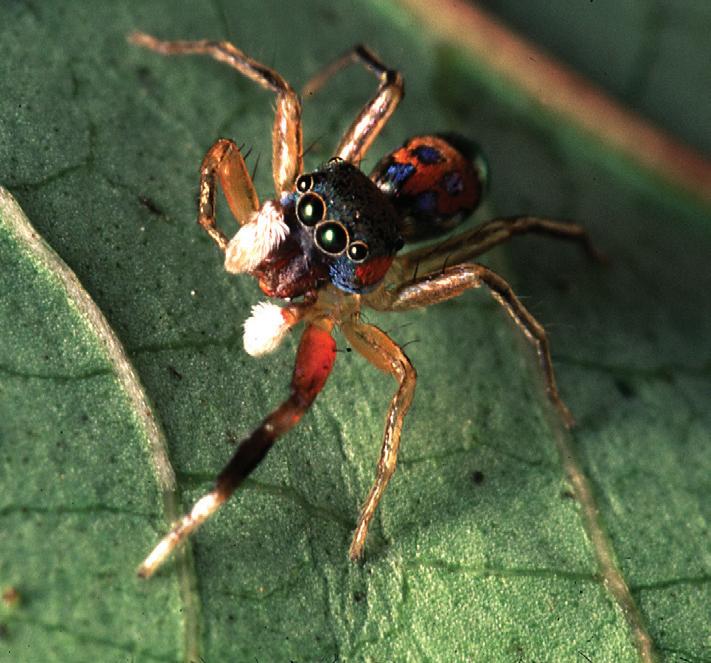
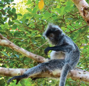
Gunung Mulu National Park is one of the world’s most intensively studied areas with 115 species of mammals identified, along with 307 species of birds, 102 reptiles, 97 amphibians, and 48 fish—cave fauna is prolific. Invertebrates number in the region of 20,000 different species. Plant species include more than 1,800 flowering plants and 1,700 mosses and liverworts. The park environment supports over 60% of all species identified on the island of Borneo.
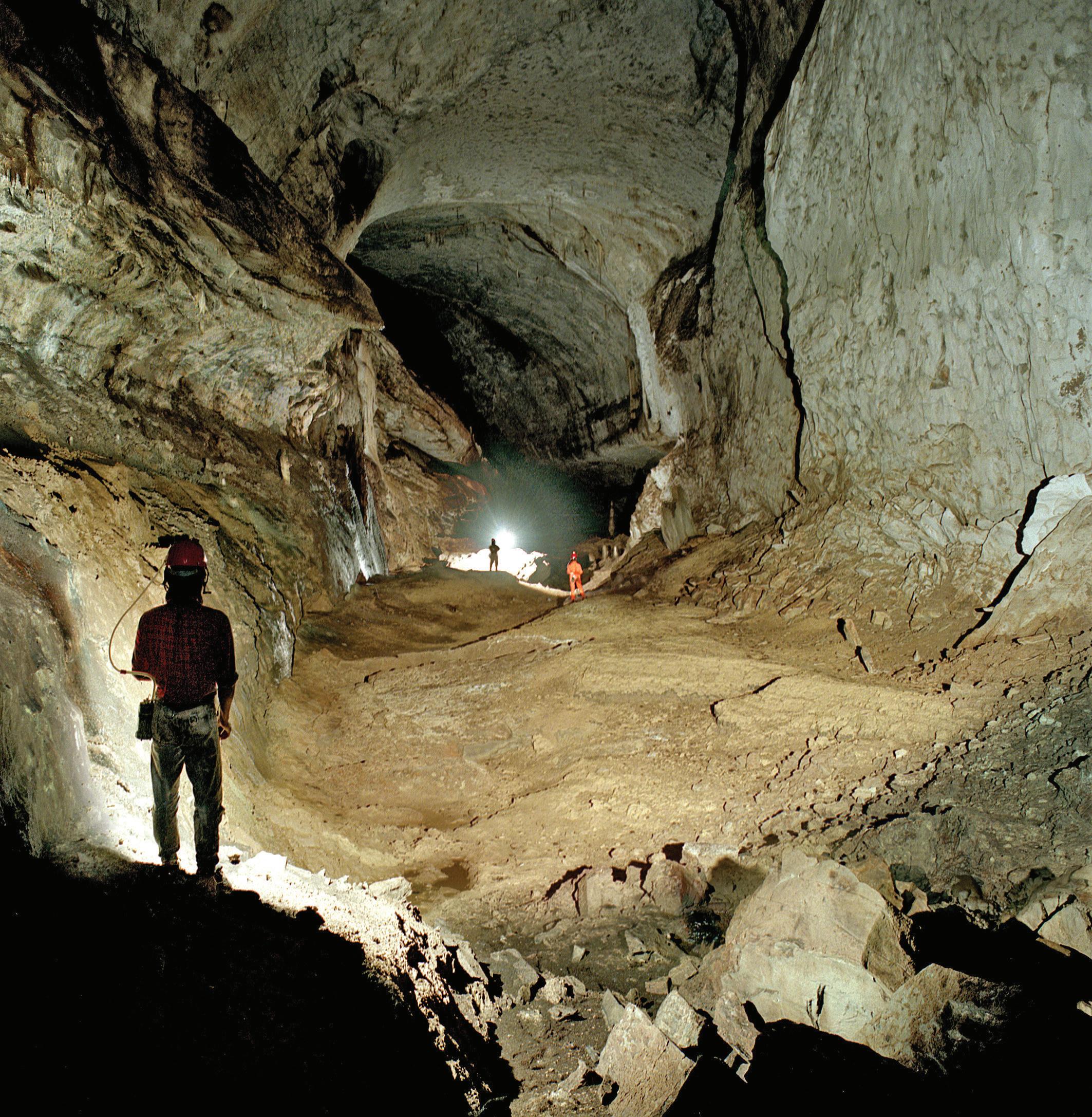
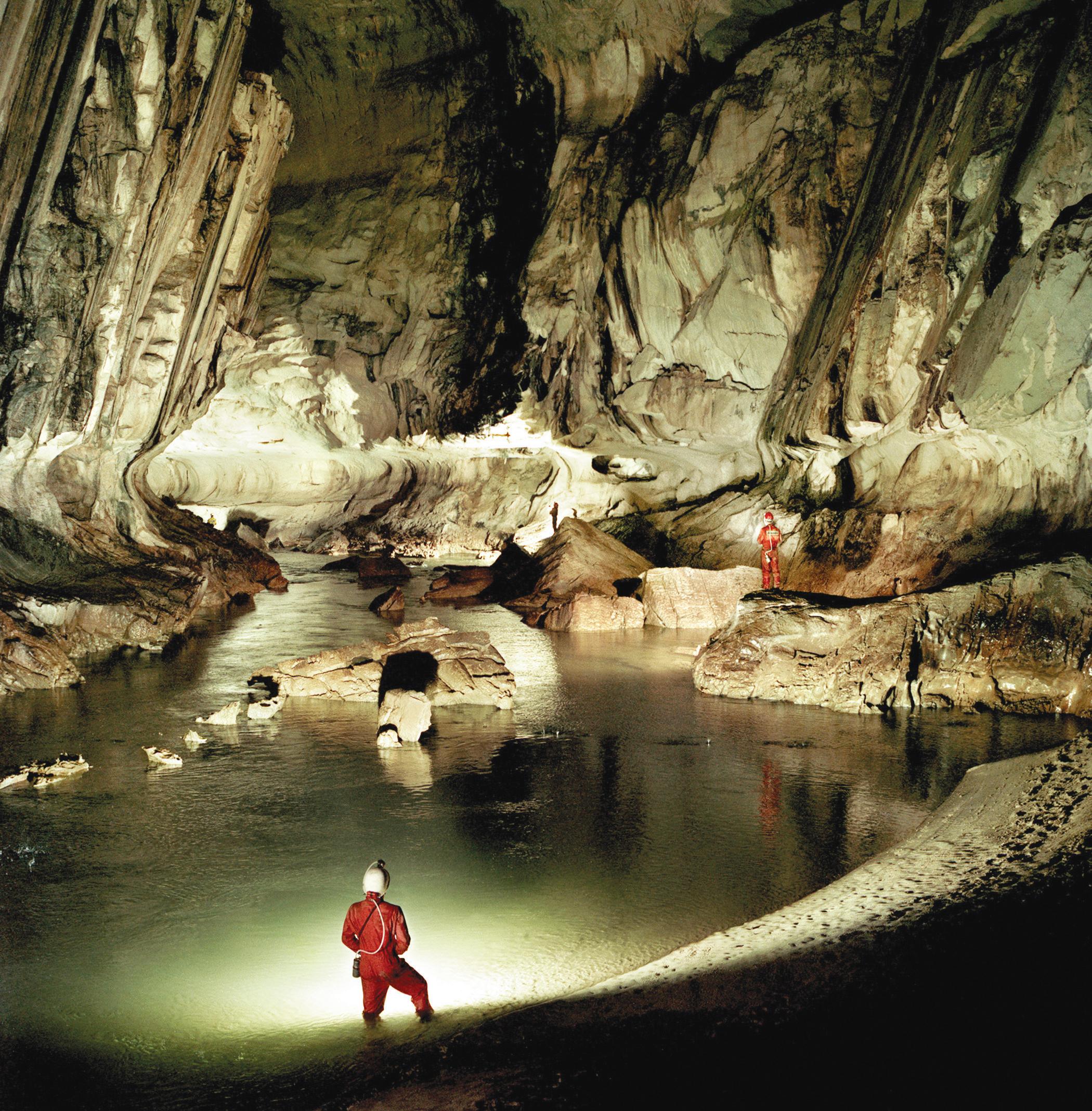
As of 2022, 458.6 kilometres of caves have been explored and mapped in Gunung Mulu National Park; including Gunung Buda, the total length comes to 549.1 kilometres. The Clearwater Cave System measures 256.1 kilometres, the eighth-longest cave system in the world. Due to the average size of the passages, this is almost certainly the world’s largest