Katie Mercer, Director of Marketing and Events + all of the Town’s dedicated employees
Prepared by Summit Design & Engineering, Inc.
List of Figures
Introduction
Woodstock’s future is bright and full of new and exciting opportunities. The Town will strive to enter a new period of prosperity while embracing its past history, using the strengths it has gained over many years to inform and guide its future. This plan represents the wants and desires of Woodstock’s community into a cohesive guide for the Town to utilize thoroughly in its future endeavors. As a guiding document, this plan represents the heart and soul of Woodstock as the Town grows in social and economic prosperity.
Simply stated, the comprehensive planning process defines where the Town is, determines where the Town wants to be, and identifies the steps it will take to get there. The process to complete this plan took place between October 2023 and December 2024, beginning with a presentation and work session with the Planning Commission on October 23, 2023, then moved into the public participation process. For more information on the public participation process please see page 20 and the appendix section of the document.
The planning team then gathered a great deal of demographic data from various sources, which forms the factual basis for the Plan. The planning team published a summary of each step of the process as a discrete deliverable, posting each on the Plan website, including: “What is a Comp Plan,” the Existing Conditions Report; the Future Land Use Map, and Woodstock Vision, Goals, and Objectives.
The draft recommendations were created by the planning team based on public input, existing conditions and planning best practices. The Planning Commission has reviewed, discussed, and considered the recommendations in the final plan document. A Public Open House on the Future Land Use Map and Vision, Goals, and Objectives was hosted in the fall of 2024 to collect community feedback before the final draft of the Comp Plan was created.
What is a Comprehensive Plan?
The Comprehensive Plan is a policy document that provides long-range guidance for the Town’s future. Woodstock will use the Plan in its decision-making about land use, transportation, and a variety of other “comprehensive” topics related to the public’s interest in the built environment. Through following the Plan, the Town can continue to strive for a high quality of life in the community over the next twenty years.
It has been almost two decades since the previous Comprehensive Plan was adopted in 2007 and last updated a decade ago in 2012. Think back to everything that has happened in the previous years, how perceptions have shifted, how technology has changed, how the housing market has flucctuated, and more. There are many complex challenges and opportunities facing communities across Virginia, and Woodstock now enjoys favorable conditions to create lasting success for generations to come.
The Plan is the result of robust community input and feedback, local elected and appointed officials commentary, focus group thoughts, and consultant recommendations to achieve a common vision for the future of Woodstock. This Plan will shape development, plan for improvements, and set expectations. However, the Plan is not set in stone once adopted. The Code of Virginia directs the Planning Commission to review the document every five years to determine if it is in need of updating, making it a “living” document that is subject to change over time, depending on shifts, new trends or changes in the community’s goals and strategies.
How is a Comprehensive Plan Used?
Local Government
The Town’s Staff, Planning Commission, and Town Council use the Plan for recommendations on land use applications. The Plan also details planned infrastructure and public facility improvements.
Community
The community can read the Town’s vision and ideas for the future. When giving public comment on land use applications, they can read the document to better understand the context.
Developers & Builders
The Plan outlines the Town’s goals and expectations of new development. This guidance helps streamline expectations, feedback, and negotiations.
Business Owners & Non-profit Organizations
Identify locations to expand, start, or relocate their business across Woodstock. Non-profits can find potential opportunities to collaborate and seek grant funding for new projects in the Town.
Legal Authority
The Code of Virginia outlines the legal authority and the requirement that all localities prepare, recommend, and adopt a Comprehensive Plan (Chapter 22, Article 3: §15.2-2223 through §15.2-2232). The statute also states that the comprehensive plan “shall be made with the purpose of guiding and accomplishing a coordinated, adjusted and harmonious development of the territory which will, in accordance with present and probable future needs and resources, best promote the health, safety, morals, order, convenience, prosperity, and general welfare of the inhabitants, including the elderly and persons with disabilities.”
Updates, Progress, and Previous Plans
The Comprehensive Plan is a living document, meaning it can be actively changed or amended to meet the Town’s needs. The Code of Virginia requires that the Planning Commission review the adopted plan and determine if any changes are needed. At the review, it is advised to evaluate how the existing plan is being implemented and if the stated goals are being met. The Planning Commission may determine that no changes are needed and no further action is required, or they may determine that specific amendments are needed, or that the entire plan needs to be rewritten.
To show ongoing implementation is being achieved, Woodstock’s Town staff should report annually to the Town Council and the Planning Commission about the Plan’s progress. This can also provide a designated time to capture any points of clarification or changes that need to be made to improve the Plan or ensure consistency with local ordinances.
Once this Comprehensive Plan is adopted by the Town Council, it will supersede the previous plan, adopted in 2007 and amended in 2012. Previous plans should be archived in order to track the trajectory of various trends and understand how the Town came make to certain decisions over time.
Relationship to Other Plans, Policies, and Ordinances
The Comprehensive Plan is a long-range, visioning and policy document that works in conjunction with other Town documents and regulations to shape the future of Woodstock’s built environment. The Plan is focused primarily on physical aspects of town development and is related to but not redundant to any strategic plans. The Capital Improvement Plan and the Town Council’s Strategic Plan may be found on the Town’s website at woodstockva.gov.
Capital Improvement Plan
Priorities, goals, and specific projects mentioned in the Comprehensive Plan should be included in future versions of or amendments to the Town’s Capital Improvement Plan (CIP). Virginia State Code Section 15.2-2239 requires that local planning commissions may, and at the direction of the governing body shall, prepare and revise annually a capital improvement program based on the adopted Comprehensive Plan. The CIP should include the commission’s recommendations as well as cost of facilities and means of financing them and is one of the primary vehicles for implementation of the Comprehensive Plan.
Zoning and Subdivision Ordinances
A locality’s Zoning and Subdivision Ordinances are the most significant and powerful vehicle for implementing the Future Land Use map in the Comprehensive Plan. The Future Land Use map (located on page 123 of this document) shows the general character desired for various parts of town in the future, and is implemented by changes to the Zoning Ordinance or Official Zoning Map, dictating how property may be developed. Over time, this changes the character of the built environment to that envisioned by the Comprehensive Plan.
Woodstock’s Mission and Strategic Plan
The Comprehensive Plan’s vision and implementing actions are in alignment with, but not redundant to, the mission and implementing steps of the Strategic Plan for the Town. The Strategic Plan is shorter term and describes actions taken over four years by the Town’s elected officials and staff to provide quality services for Woodstock residents, including policies and tasks that are not related to Land Use. However, the Town can use the Strategic Plan to prioritize certain tasks that are important to the vision of the Comprehensive Plan, or specific Actions from the Plan, in order to ensure effective implementation.
Planning Context
Existing Conditions Report
The Comprehensive Plan is based on both empirical data and the community’s vision. The planning process begins with an “Existing Conditions Report” to collect and analyze data to understand where the Town of Woodstock is today. Understanding where and how people live, what major employers are in the area, what the environment looks like, or how the transportation system is functioning, gives the community a common foundation for thinking about their vision for the future. Topical data that has been analyzed is found across this plan’s chapters that discuss the community’s housing conditions, economic conditions, transportation systems, environmental conditions, local community facilities, and the use of land.
People tend to have subjective understandings of their own community based on their individual experiences. While it is important to understand different perspectives, it is also important to examine objective data. This process helps ensure that all community stakeholders are starting from a common understanding of the Town’s conditions at the beginning of the planning process. Once this is established, the community can work collaboratively to address its needs. This data helps identify potential issues in the Town and with drafting recommendations to improve conditions. The data has also been used to draft the Comprehensive Plan’s vision alongside information from public engagement.
Where did the data come from?
Most of the data comes from the 2021 American Community Survey (5 year estimates), released on December 8, 2022, by the United States Census Bureau. This data was the latest and most available at the time. However, this document also utilizes other data, such as Decennial Census counts, Virginia Employment Commission, and Esri Business Analyst. All of these sources are widely used and as accurate as possible to give communities a picture of their existing conditions.
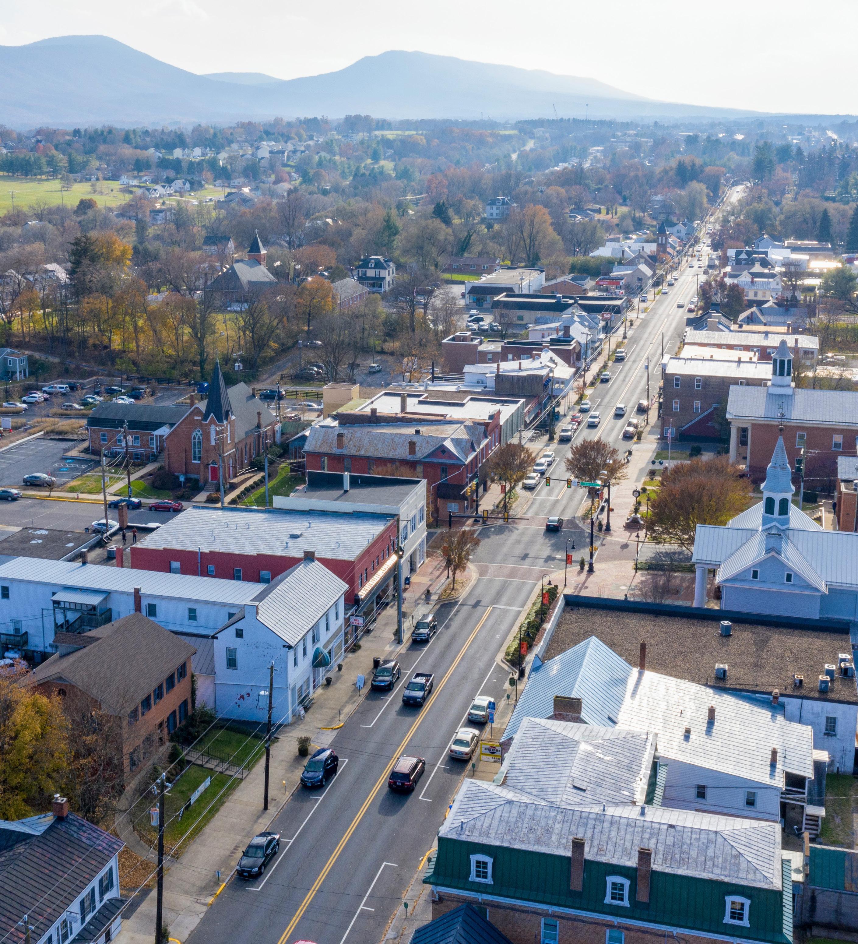
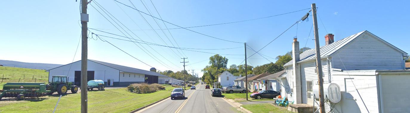
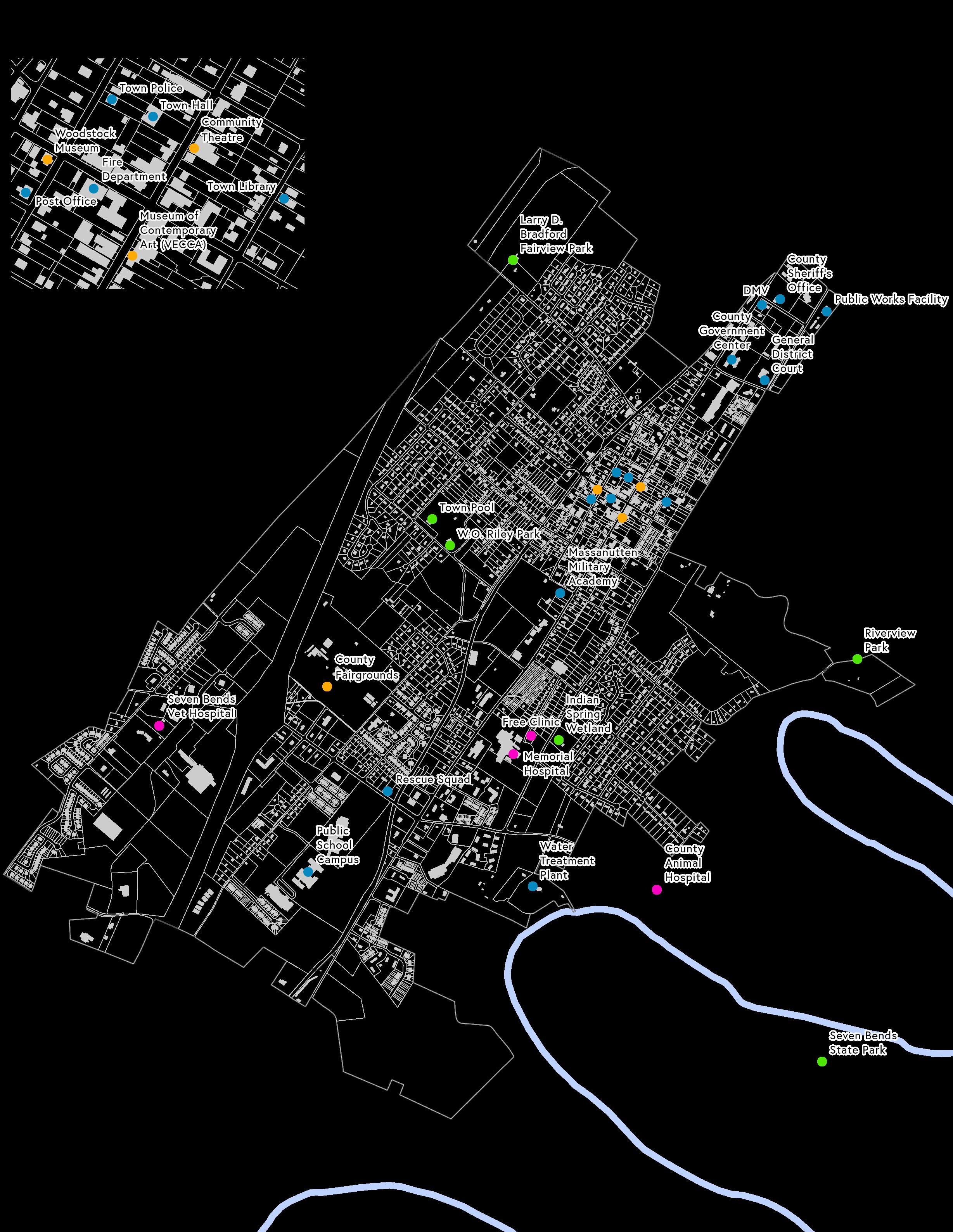
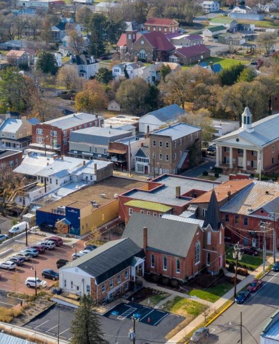
The Town of Woodstock is nestled in the Shenandoah Valley along the historic “Great Wagon Road.” Formally chartered in 1761, it is one of the oldest Towns in both Virginia and the United States. It is the County seat of Shenandoah County.
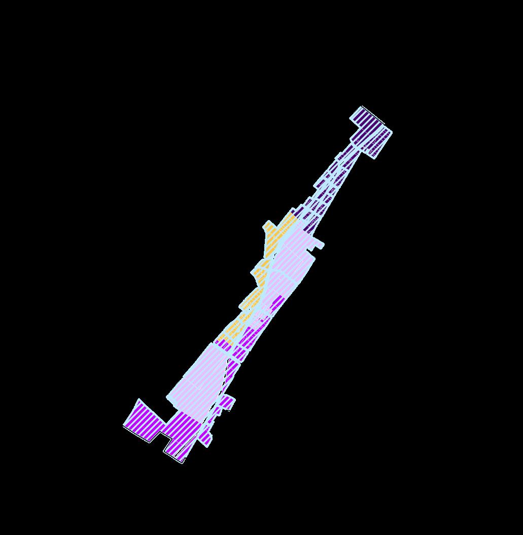
The Town’s land area is approximately 2,436 acres. While its boundaries do not directly run adjacent to it, the Shenandoah River’s many bends meander nearby. Seven Bends State Park provides formal access to recreation along the river.
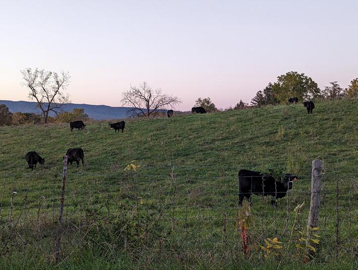
While Woodstock is generally developed, there are still some active farms within Town boundaries. Just outside the Town boundaries, there are many active farms that lend themselves to the visual character of the area.
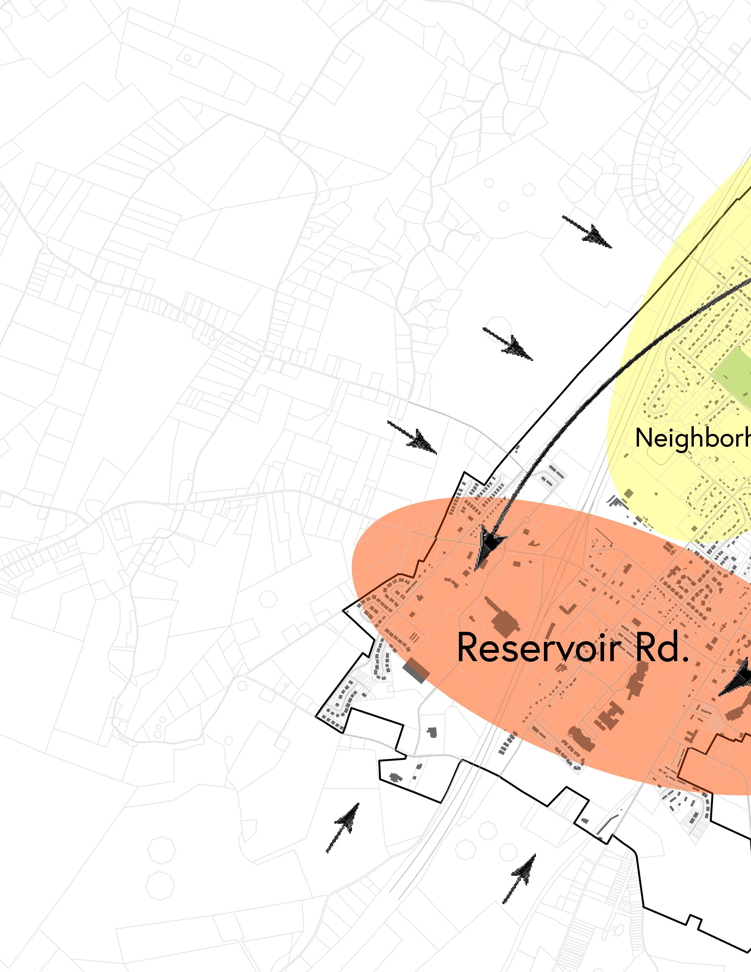
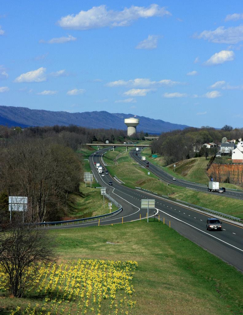
Two major roads bisect the Town. State Route 11, which runs North to South, and Interstate 81, which also runs North to South, parallel to Route 11. State Route 42, or West Reservoir Road, provides East to West access deeper into Shenandoah County.
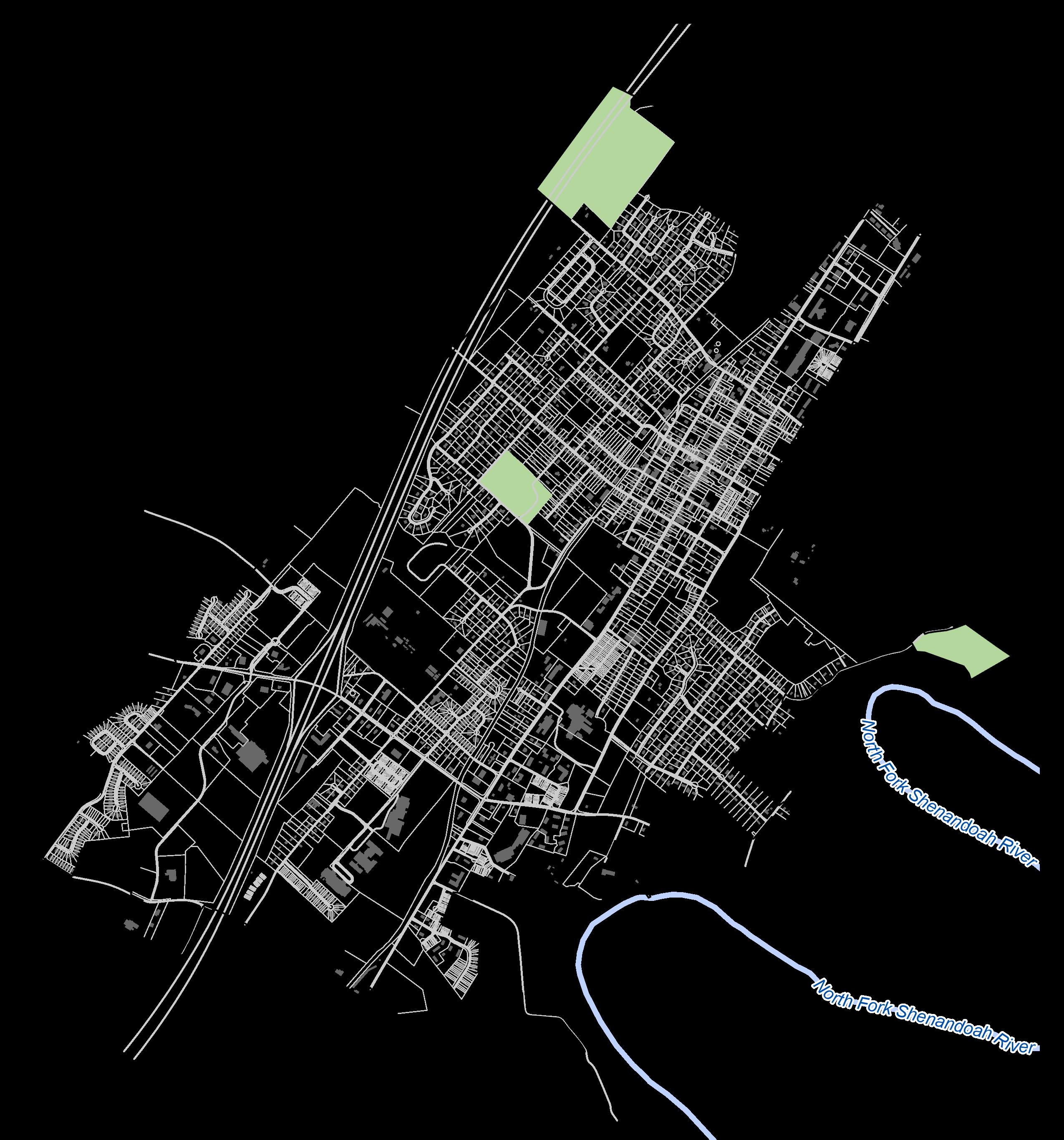
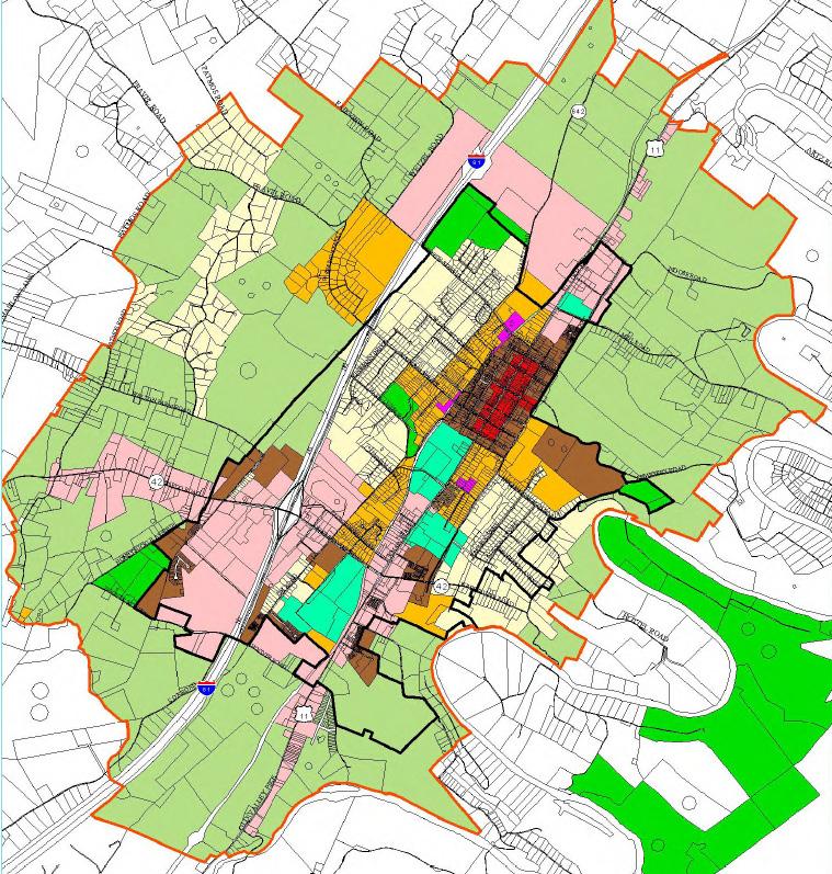
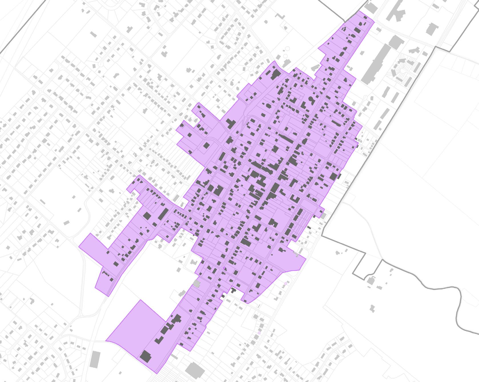
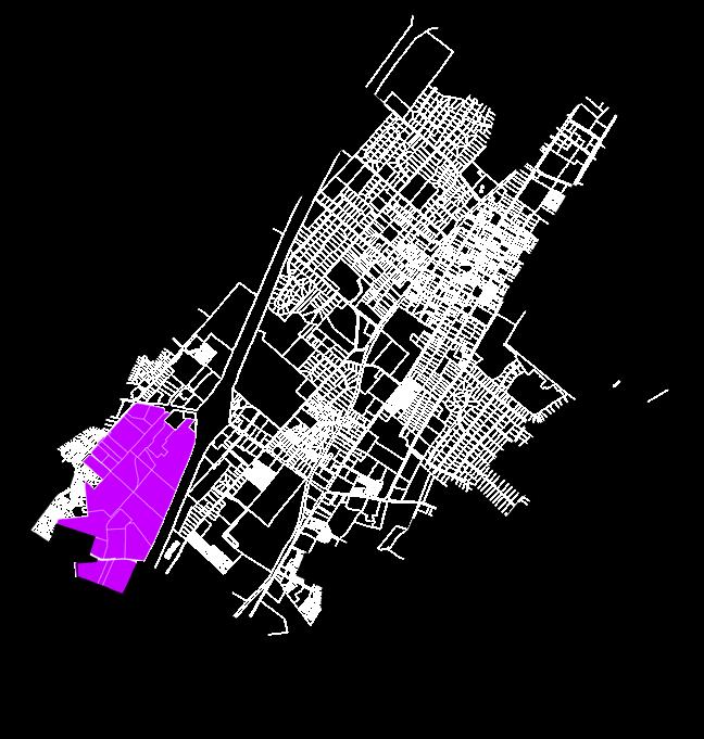
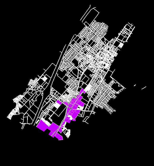
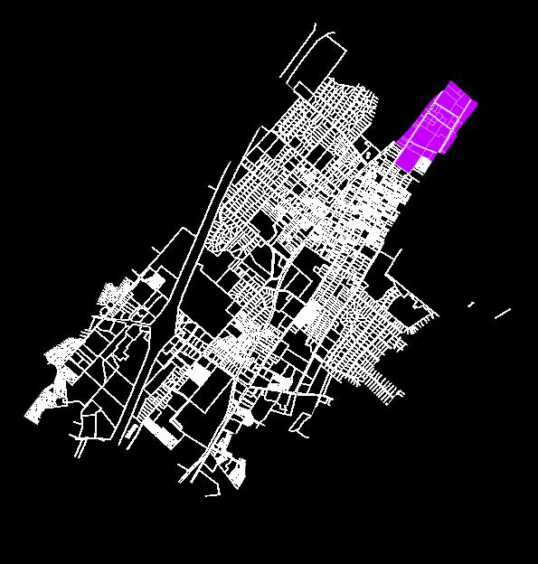
Figure 1. Figure-Ground Map
Regional Context
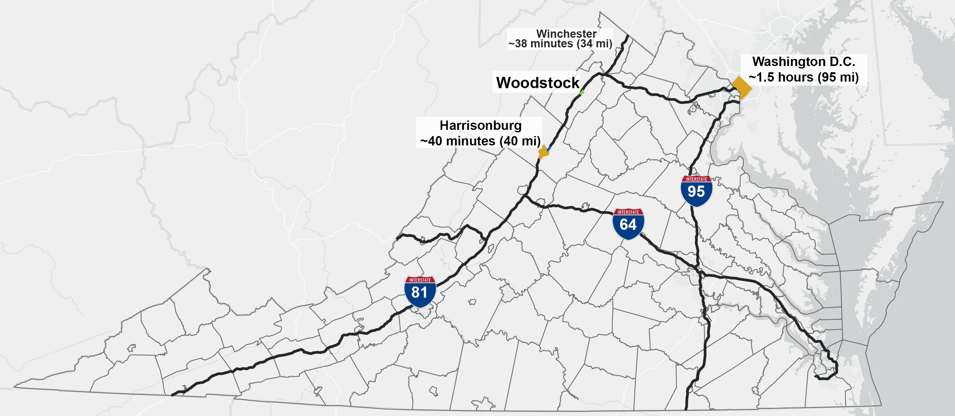
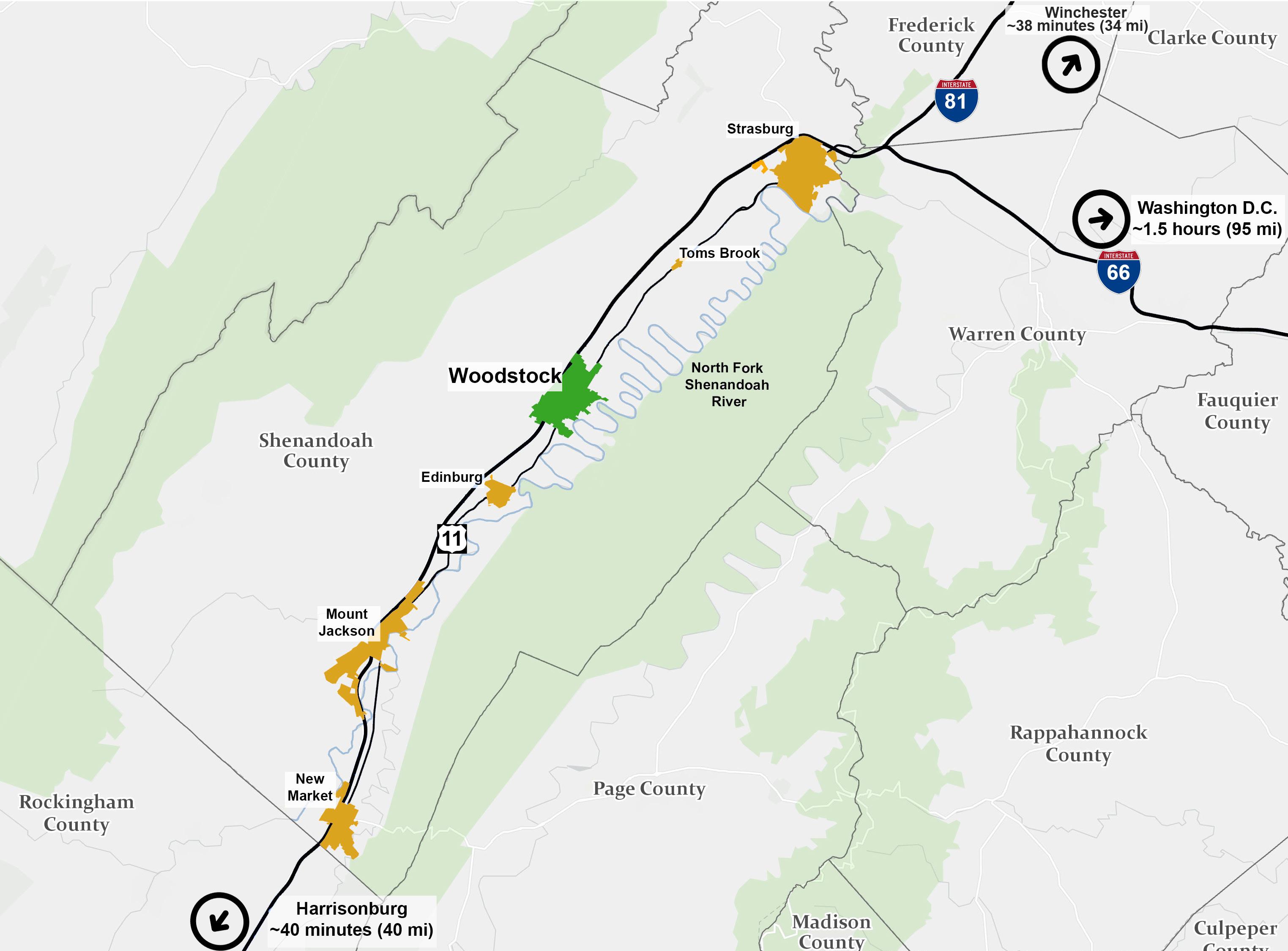
The Town is part of a string of communities, such as Strasburg, Edinburg, and Mount Jackson along the Route 11/Interstate 81 corridor, which follows the historic “Great Wagon Road.” As shown on the following maps, the Town is about 95 miles from Washington, D.C. and 40 miles from Harrisonburg. Regionally, it is approximately the midpoint between the cities of Winchester and Harrisonburg.
George Washington & Jefferson National Forest
George Washington & Jefferson National Forest
West Virginia
Figure 2. State-wide Context Map
Figure 3. Regional Context
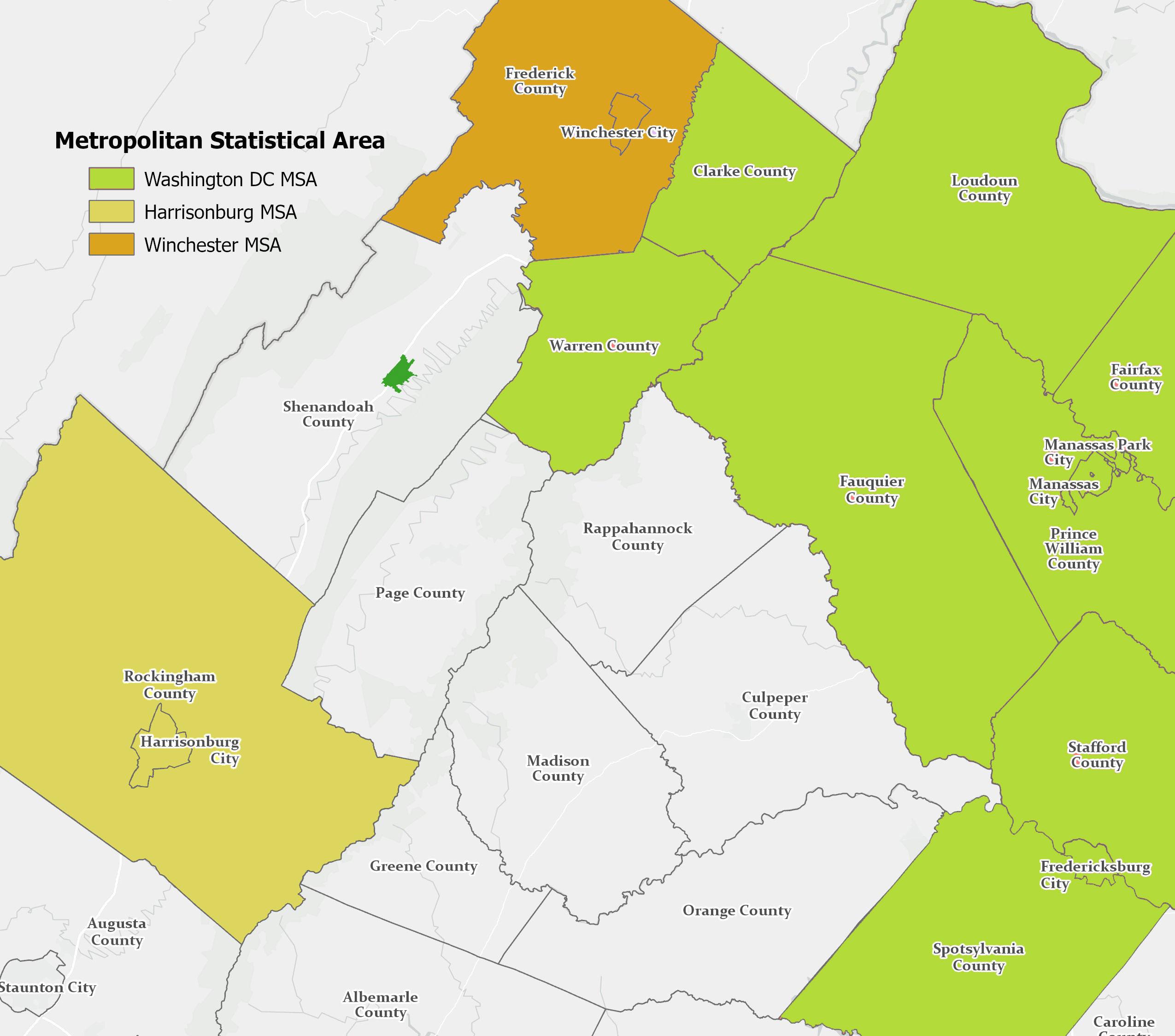
Surrounding Metro Areas
Metropolitan statistical areas (MSA) are the definition of a region, used by the US Census Bureau. An MSA consists of a core area that serves as a “population nucleus” and surrounding areas that have a “high degree of economic and social integration” with that core. MSAs are delineated, in part, through commuting patterns.
Woodstock is located near the MSAs of the City of Winchester and the City of Harrisonburg, as well as being located just outside the Washington-Arlington-Alexandria, DC-VA-MD-WV MSA. This is Virginia’s highest density area of economic activity and population, where growth has generally “sprawled” its way further and further into the countryside. This is important to note for planning purposes, as within the comprehensive plan’s horizon the Town may face sudden growth pressure. However, with careful planning the Town can manage this pressure so that it minimizes the impacts to the Town’s services for its existing residents.
Woodstock
Figure 4. Metropolitan Areas Map
Demographics
Population
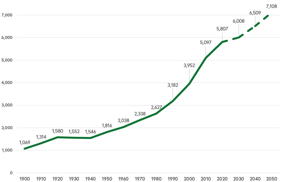
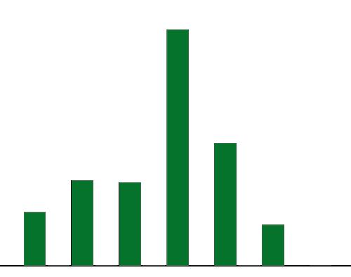
The total population of the Town of Woodstock is estimated to be 5,716 people as of the 2021 American Community Survey 5-Year Estimates. The more accurate, but now outdated count in the 2020 Census is estimated at 5,807.
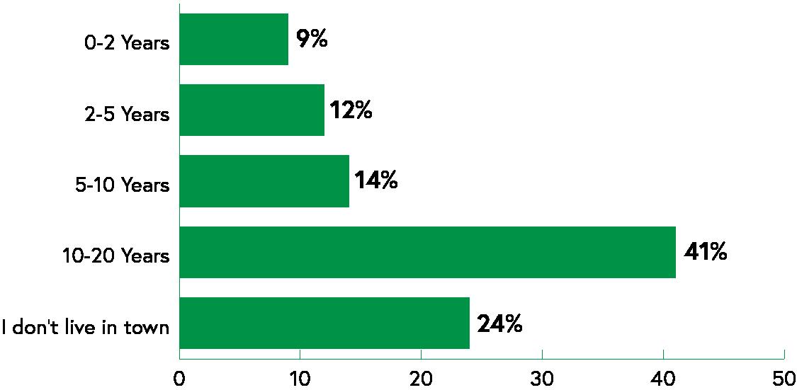
The graph above shows the Town’s population increase since the beginning of the 1900s. Notably, the population has grown almost every census of Woodstock’s history, particularly through the middle of the 20th century. Across Virginia, many small towns are struggling with the impacts of population loss. However, Woodstock has a history of a steady increase in population throughout the period of record of its history.
The University of Virginia’s Weldon Cooper Center for Public Service provides population projections for the Commonwealth’s localities. Woodstock’s population is expected to add around 2,000 people by 2050. It is important to plan for infrastructure and land use patterns that accommodates the needs of current and future residents. Growth projections attempt to give an idea of what may happen in the future, but its important to note that growth could drastically exceed or fail to meet the forecasted numbers. The comprehensive planning process will provide the Town with strategies to accommodate growth to maximize the benefit to existing residents.
Source: 1900- 2020 Decennial Census, Weldon Cooper Center for Public Service
Figure 5. Population Growth Over Time
Census Data
The United States Census Bureau has two major methods for collecting demographic information. The decennial census, required by the Constitution and conducted every ten years since 1790, is a short survey of every household in the country. The American Community Survey (ACS) is a longer form containing more questions, taken every year. It is published annually, and seeks to maintain accurate estimates by comparing the 1 year results with sets of 5 years. The decennial census has a smaller number of data points, like population, sex and race, with a lower margin of error. The ACS has a much larger number of data points (like social, economic and housing characteristics) and a wider margin of error. A mix of decennial census and ACS data is used to form the empirical basis for the Comprehensive Plan, to report a picture of the community as accurately as possible. This plan uses a combination of Decennial Census data and 2021 ACS 5 Year Estimates, which is the most recently available data as of the creation of this document.
Population Change Comparison
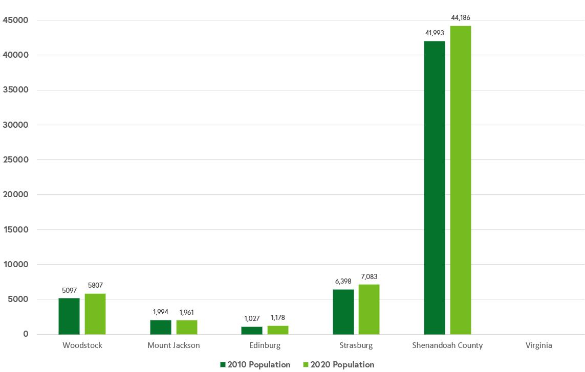
The graph below shows population change by percentages between the 2010 and 2020 Decennial Census with comparisons to other neighboring and rural localities in the region. Woodstock’s changed at a similar percentage as Strasburg and Edinburg, showing that over 10% growth has occurred in the last ten years, or on average 1% of growth per year. With neighboring localities experiencing similar growth, the region is evidently attracting many new residents.
2010 & 2020 Decennial Census, P1
Figure 6. Population Comparison
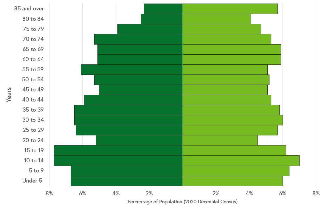
Age
The median age in the Town of Woodstock is estimated at 39.1. For comparison, the median age in Virginia is 38.8. The age pyramid above shows Woodstock’s population grouped by sex and age category. Woodstock’s population appears to be getting younger. For example, the median age for the 2010 American Community Survey estimates was 46 years old. The population pyramid above is made using 2020 Decennial Census information because it is considered more accurate than the American Community Survey, although this information is not the latest available. In many communities, the pyramid looks “inverse,” with a larger aging population over top of a thinning younger population. This can create a difficult situation in continuing to support a robust economy while providing the services that the aging population also relies on. In Woodstock, this is fortunately not the case with the Town’s population growing and getting younger there is a strong foundation for continued vitality in the community. However, the Town could improve even further by ensuring that its younger generation is especially attracted to and able to make Woodstock their home in the future. The lower percentage of the population between 20 and 34 shows where potential residents are moving away for college or other opportunities.
Median Age: 39.1 Men: 37.3 Women: 41.8
2020 Decennial Census
2021 American Community Survey, 5-Year Estimates, DP05
Figure 7. Population Pyramid
Figure 8. Age & Sex Summary
Race and Ethnicity
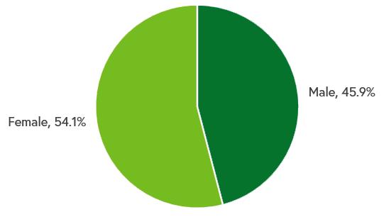
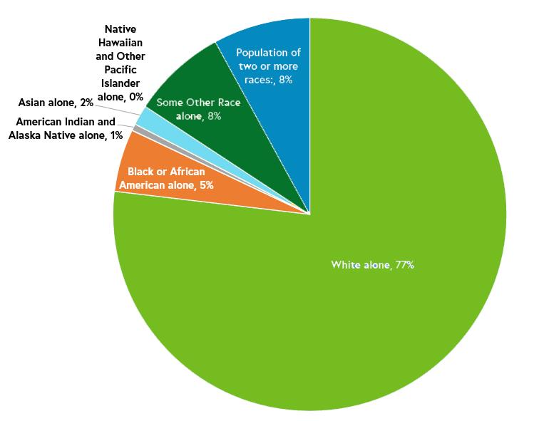
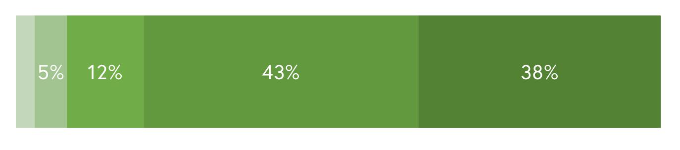
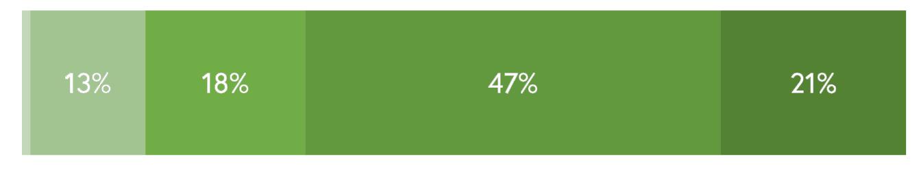
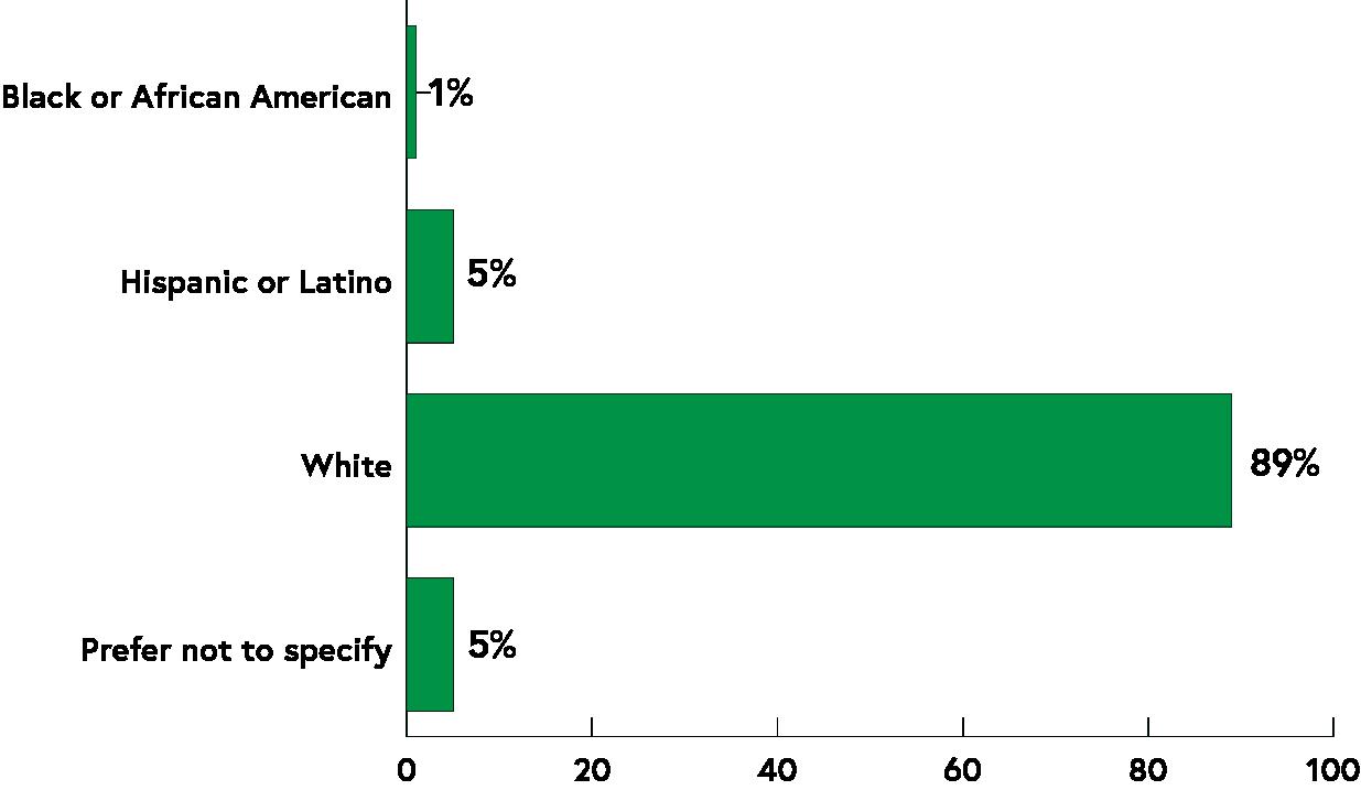
According to 2021 American Community Survey data, 77% of Town of Woodstock identifies as “White alone,” while 5% identify as Black or African American. 8% of the population identifies as Biracial. Other racial groups, such as Asian, Pacific Islander, American Indian, or Other Race Alone make up 3% of the Town.
2021 American Community Survey estimates 19% of Woodstock’s population identify as Hispanic or Latino.
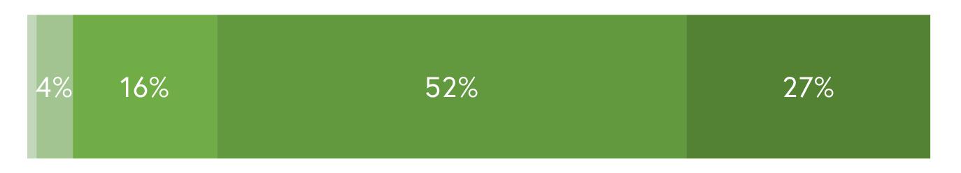
Educational Attainment
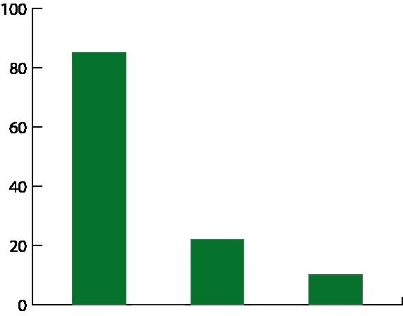
The population of the Town of Woodstock that is over the age of 25 totals approximately 3,897. Of this total, 85% are high school graduates or higher. However, only 22% of the population holds an Associates or Bachelor’s Degree and only 10% hold a Graduate or Professional Degree. Woodstock’s economy has not been historically reliant on the need for higher education as a result of a primarily agricultural economy in the region. However, as technology advances, high speed internet access increases, or other resources become available, new businesses may locate in the Town of Woodstock. Additionally, members of the community leaving to pursue higher education may choose to return to the County again with new skills and education to further develop and contribute to Woodstock’s local economy.
2021 American Community Survey, 5-Year Estimates, S1501
2021 American Community Survey 5-Yr. Estimates, DP05
Figure 9. Race by Percentage
Figure 10. Educational Attainment
Public Participation
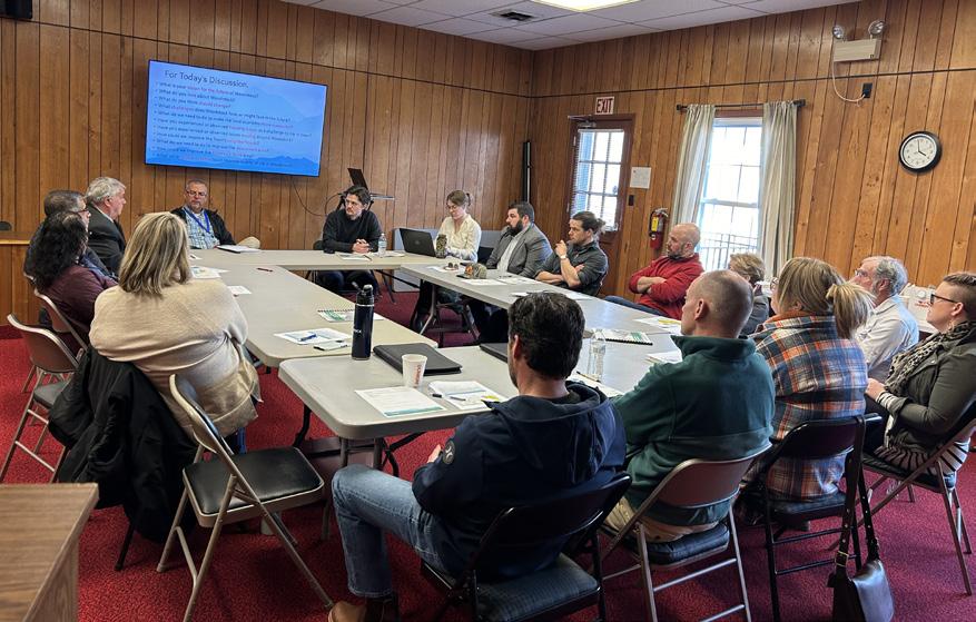
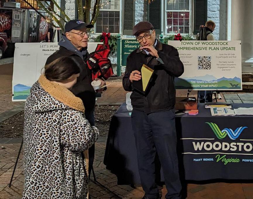
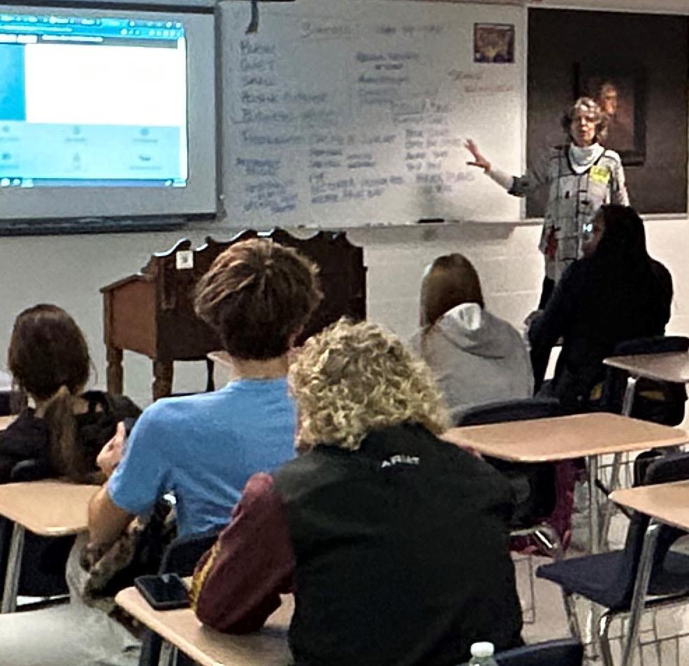
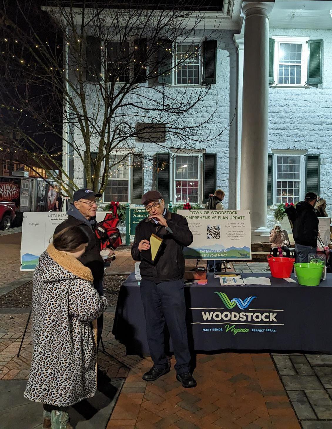
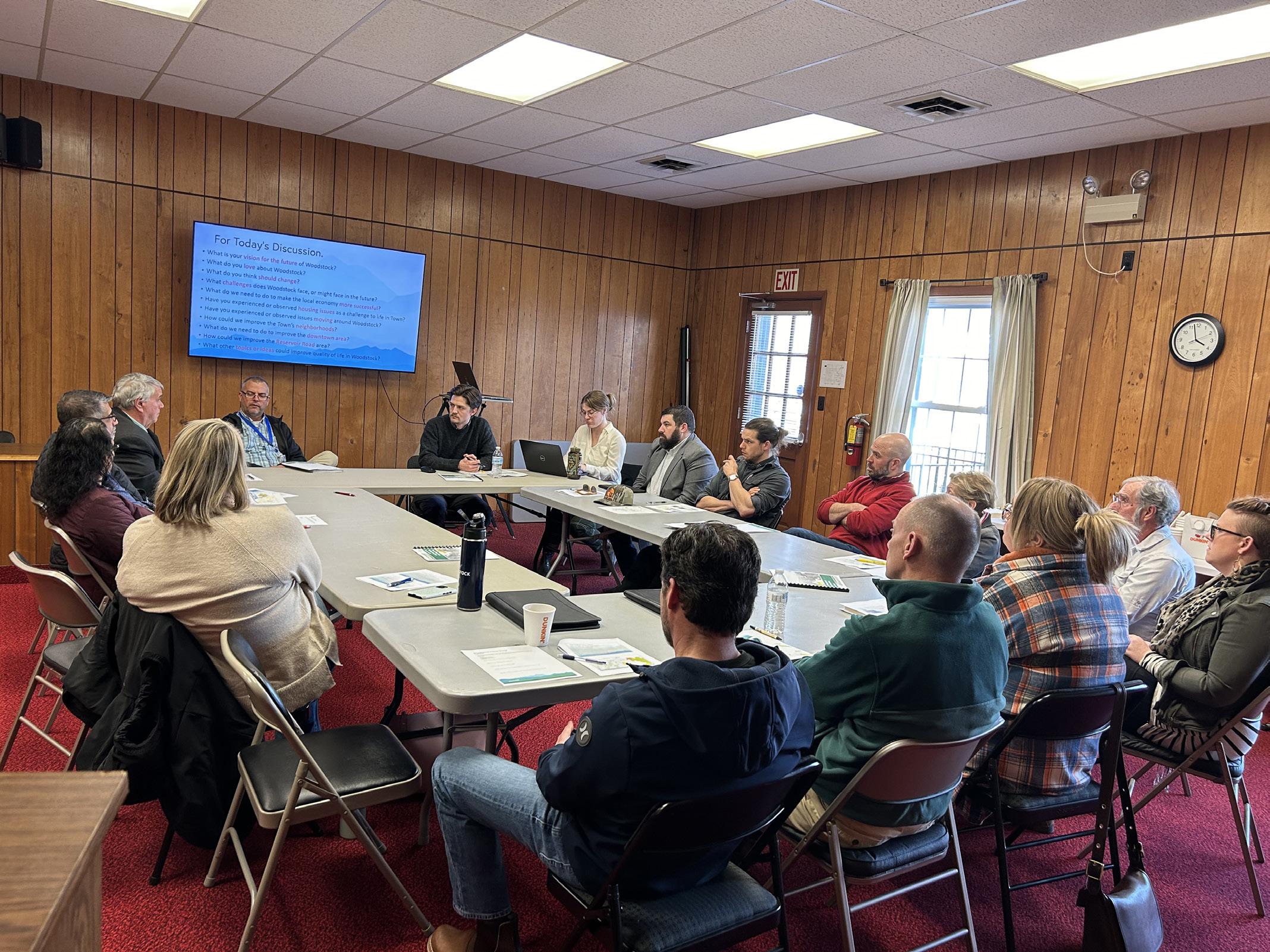
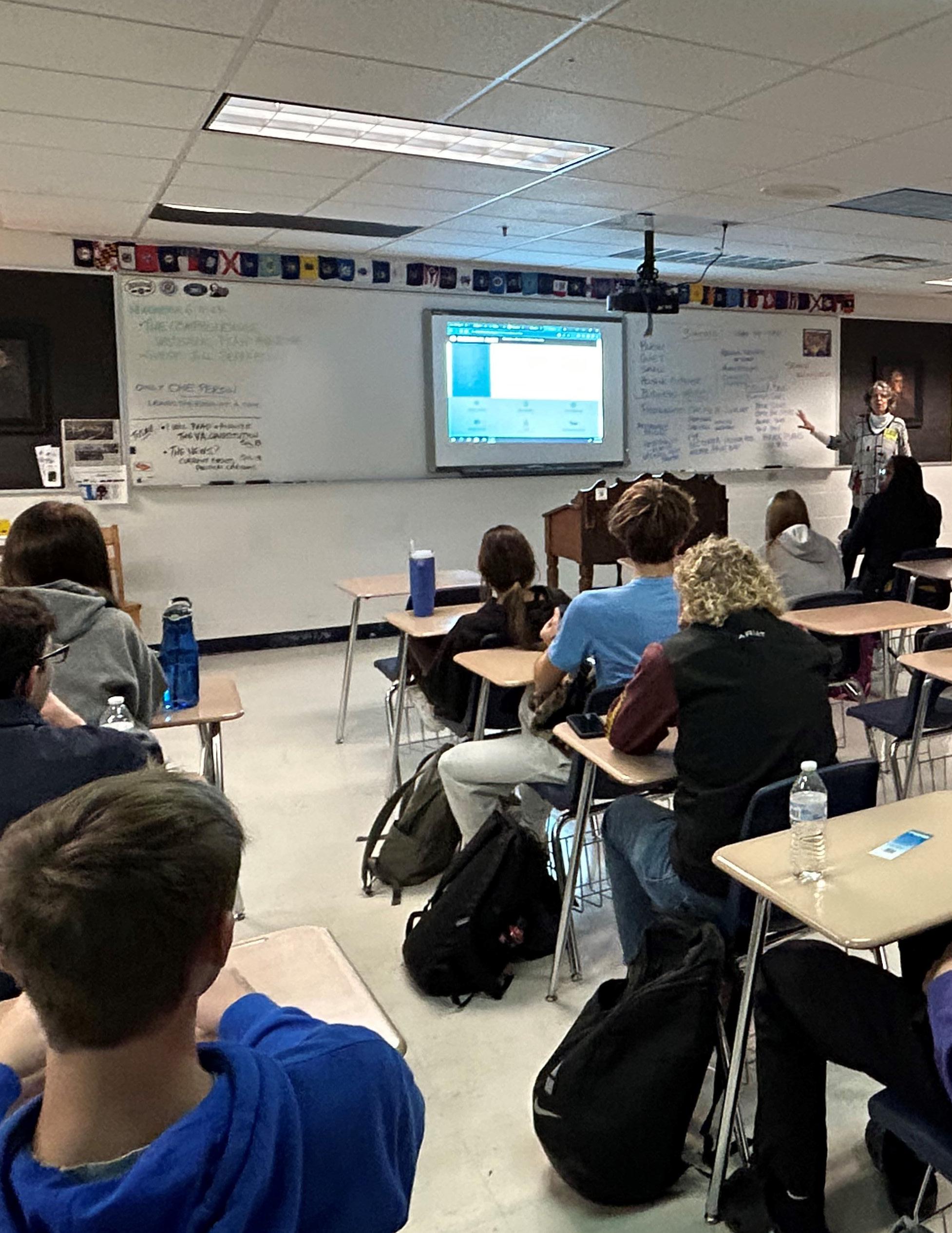
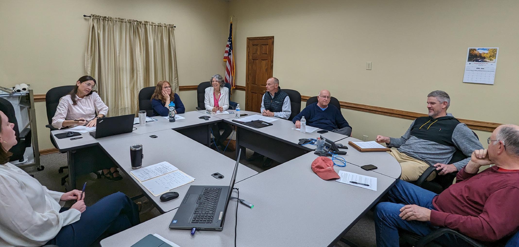
The Plan has been created with the input of as many Woodstock residents and local stakeholders as possible. All people who live, work, or regularly visit Woodstock were invited to provide their opinions, experiences, and vision for the Town. When combined with demographic data and existing conditions analysis, the input forms the foundation for the plan. Engaging the community is an important part of determining what the Town’s collective vision is for the future, as well as what current needs should be addressed. No one knows better what Woodstock needs than the people who call it home! The community gave input through: The Public Survey, Planning Commission Kick Off (October 23rd, 2023), Light Up Woodstock Tabling (December 1st, 2023), Community Focus Group (February 14th, 2024), Woodstock Staff Focus Group (January 16th and 26th, 2024), Economic Development Authority Meeting (February 22nd, 2024), Plan Open House (October 21st, 2024) and Other Interviews and Meetings (Includes local business owners, Shenandoah County Administration and Public Schools, Central High School and Triplett Tech students). The full results and summaries of these meetings are summarized in the Appendix at the end of the plan. With both quantitative data and the qualitative responses gathered, Woodstock’s plan for the future is fully reflective of where the Town is, and where it wants to go.
How was the Public Survey Conducted?
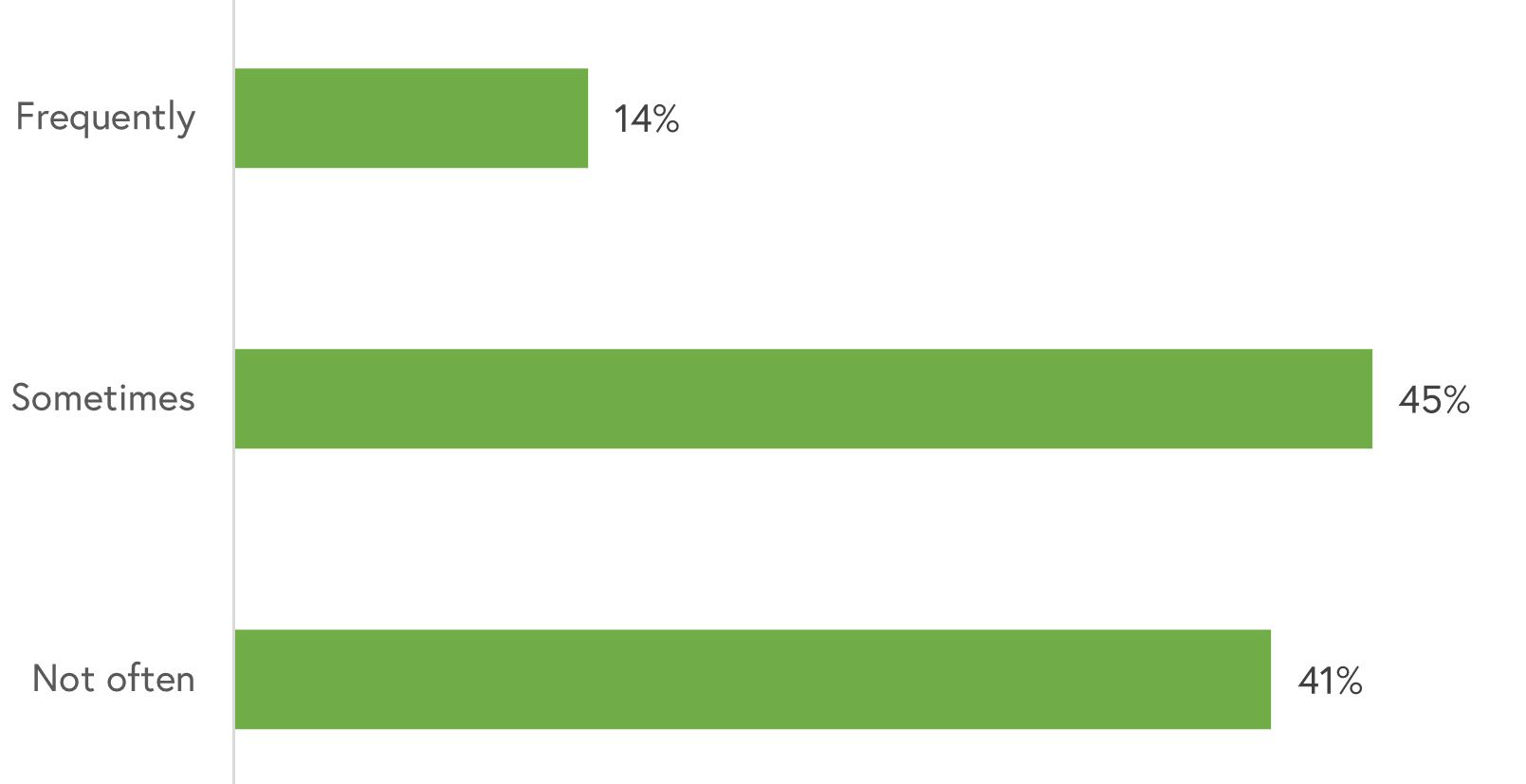
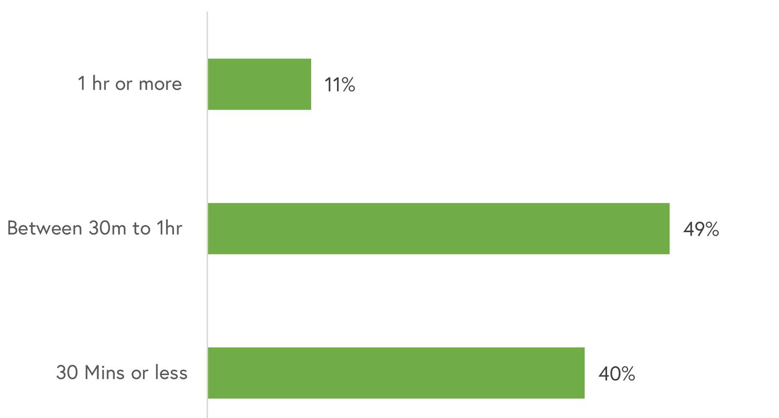
The survey was hosted on Woodstock’s Polco community engagement account. It was open to anyone interested in providing public feedback to the Town, whether they live, work, or own a business. The survey was launched on November 1, 2023 and remained open until March 31, 2024.
During the survey’s five month period, 141 residents and neighbors submitted survey responses.
Surveys help elected and appointed officials, the Town’s staff, and the public to understand their community goals and make informed decisions for future growth, infrastructure, and other needs. The responses from this survey have been used by the Town to inform and develop the Comprehensive Plan, accounting for the needs and desires of residents, neighbors, and visitors alike.
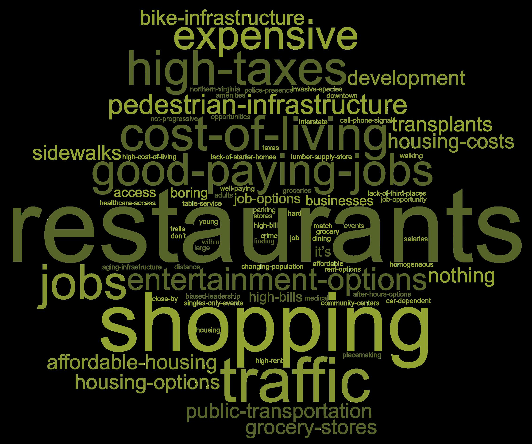
Please see the full Public Participation Summary in the Appendix of this document. On the next pages are three word clouds that show prevalent answers to survey questions, which give a good overview of stakeholder views of Woodstock’s present and future. The recommendations in this plan are in direct response to these and other stakeholder responses and priorities, taking care to preserve what people love about Woodstock while proactively addressing concerns for the future.
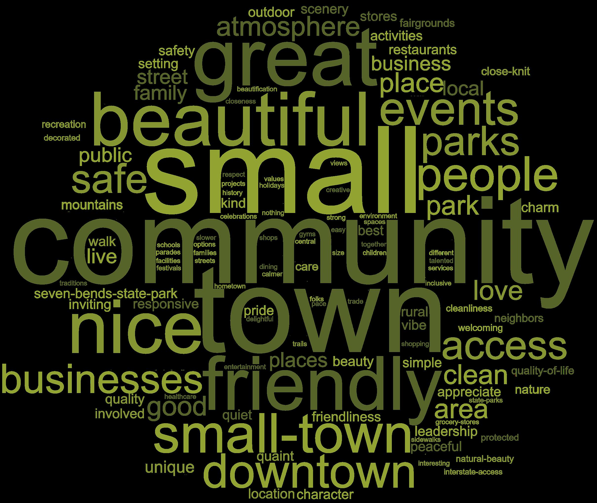
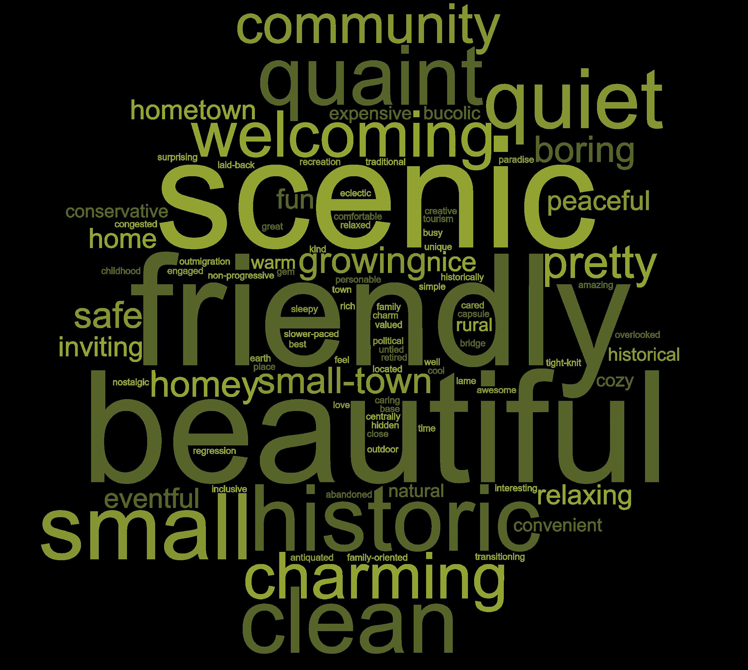
What are three words that describe Woodstock?
When asked which three words describe Woodstock, the words most mentioned were “scenic,” “friendly,” and “beautiful.” While true, this might have been partially influenced by being the example for this question. The next three most mentioned words were small, historic, clean. Other words that were mentioned often include: charming, welcoming, quaint, and quiet.
Figure 11. Word Cloud (Three Words)
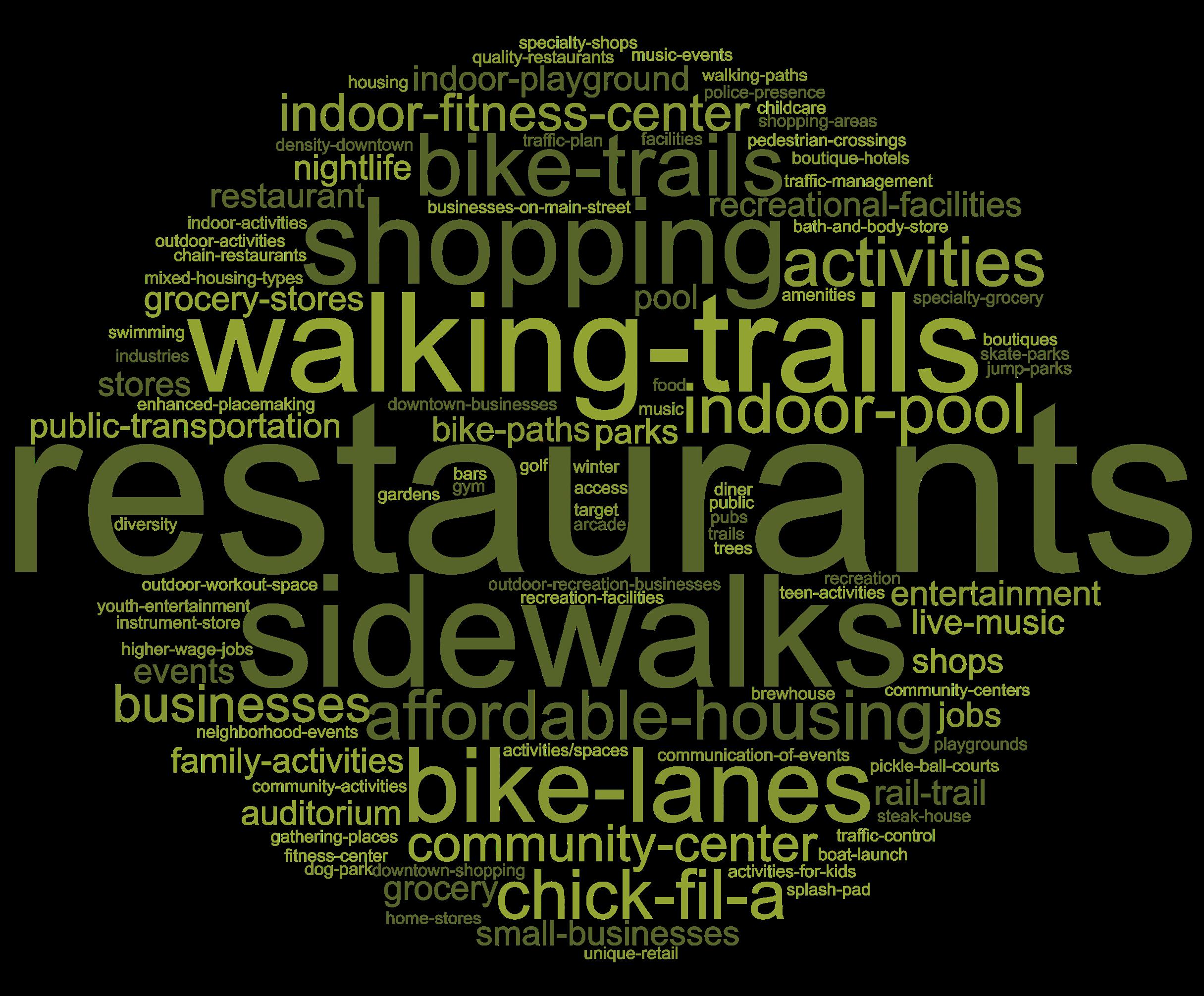
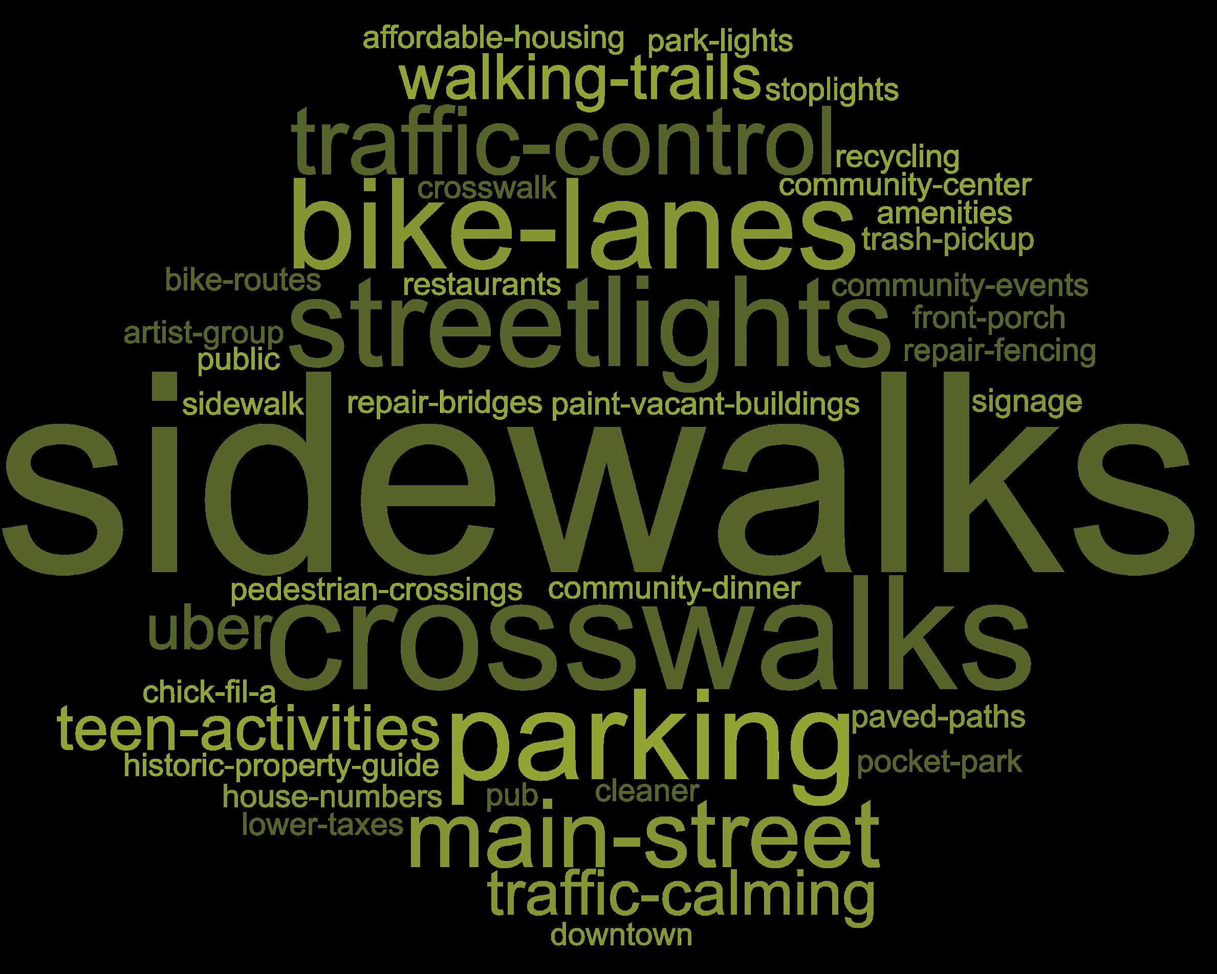
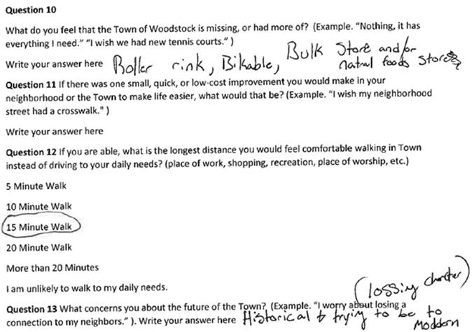
What do you feel that the Town of Woodstock is missing, or had more of?
When asked what Woodstock was missing, respondents stated that the Town needed more restaurants, sidewalks, walking trails, shopping, and bike amenities. Respondents want more active uses and activities in their downtown to walk or ride their bikes to, including splash-pads, home stores, and public music events in the park. One respondent stated they wanted a “dedicated outdoor workout space and community activities incorporating music and events.” This sentiment was reciprocated for many other respondents, as the desire for activity and events bringing community members together is widespread.
Figure 12. Word Cloud (Town’s Missing)
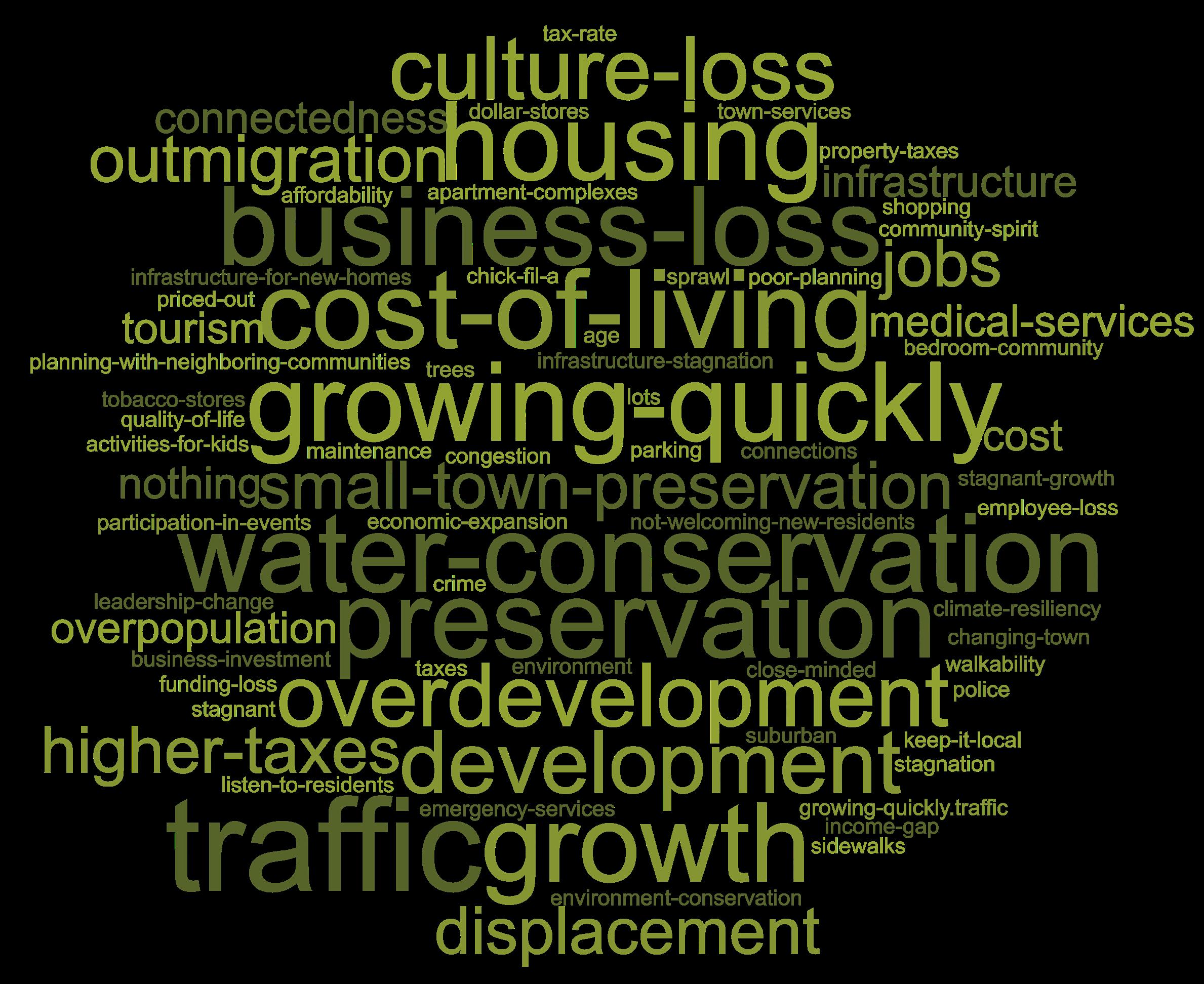
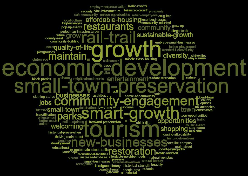
What concerns you about the future of the Town?
Survey respondents had a diverse range of concerns for the future of their town. The most recurring concerns were preserving the small town character, traffic, loss of small businesses, cost-of-living, growing too quickly, and housing. Some notable responses included, “I worry about the town losing it’s ‘small-town’ feel or losing local businesses,” and “The people coming up don’t have enough housing to choose from.” Many respondents also mentioned resiliency and preserving natural beauty: “[I am concerned about] climate change and ensuring that the Shenandoah River can meet the water needs of the region,” and “[My biggest concern is] managing water resources and community safety for a growing population.”
Figure 13. Word Cloud (Town’s Future)
Our Vision:
“Woodstock is the thriving heart of a verdant valley, where social and economic prosperity is generously shared and passed from generation to generation.”
Vision + Big Ideas
Overview
The Vision Statement is a key piece of the Comprehensive Plan that sets the tone and direction of the document. The message identifies the higher level aspirations that the Town is looking to achieve. The statement is clear and be based on the consensus, goals, and needs expressed through the community engagement process. The Public Participation Summary document is available in the Appendix section of the Plan to see the full range of responses from the community. The comments have provided invaluable insight into what the community finds as important for the Town to plan for.
These sentences capture the community’s future vision of Woodstock. The statement emphasizes Woodstock’s location in the beautiful Shenandoah Valley and its role as the center of economic, political, and cultural life in the area. It aspires to physical connectedness through infrastructure, as well as community connectedness through social and economic prosperity. The statement concludes with Woodstock’s high quality of life passing from generation to generation, aspiring that through time the Town will always be a wonderful place to age or grow up in.
The phrase “small town charm” comes up often when discussing why people enjoy living in Woodstock When people are asked to elaborate, the response is usually centered on the sociable nature of the community. People are happy to know their neighbors and support local businesses in Town. The statement seeks to go deeper into this phrase and encourage the Town to work on what creates the charm that people love so much about Woodstock.
Big Ideas
The vision is followed on the next pages by the Plan’s “Big Ideas.” These help explain where different topics that the Plan covers come together to address an issue. For example, when read separately the Land Use and Transportation objectives may appear to focus on different issues, however, together they are working on an overall goal of “weaving the activity centers together.” The “Big Ideas” are:
1. Weave activity centers together - This idea works to unite the character and walkable quality of the historic downtown with the rest of Woodstock, connecting the Town with new development that expands the fabric of places to go in Town.
2. Build on Woodstock’s Foundation - Shifting from the previous Comprehensive Plan, this Plan seeks to redevelop and infill available land in Woodstock, building on the foundation of what exists in Town rather than “sprawling” into the rural landscape.
3. Foster high quality spaces - The Plan seeks to improve the quality of architecture and public spaces that come with new development to create new shared value with new development. This will allow for growth that “gives back” to the community in a higher quality form that promotes the local economy and sociability.
4. Activate Woodstock - Placemaking is encouraged throughout Woodstock, as part of development, temporary uses, or in unlikely spaces. For example, a public parking lot can be transformed into a temporary space for fun events. This will bring the community together and allow for new creative events.
These ideas are explained in greater detail throughout the next section of the Plan.
Big Ideas
1. Weave activity centers together.
2. Build on Woodstock’s Foundation
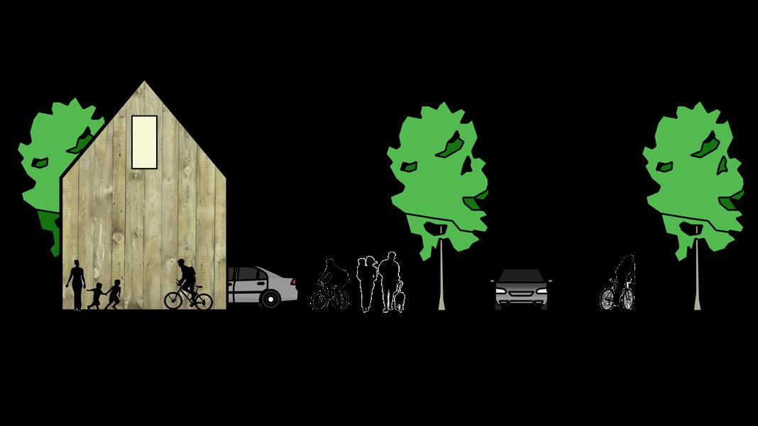
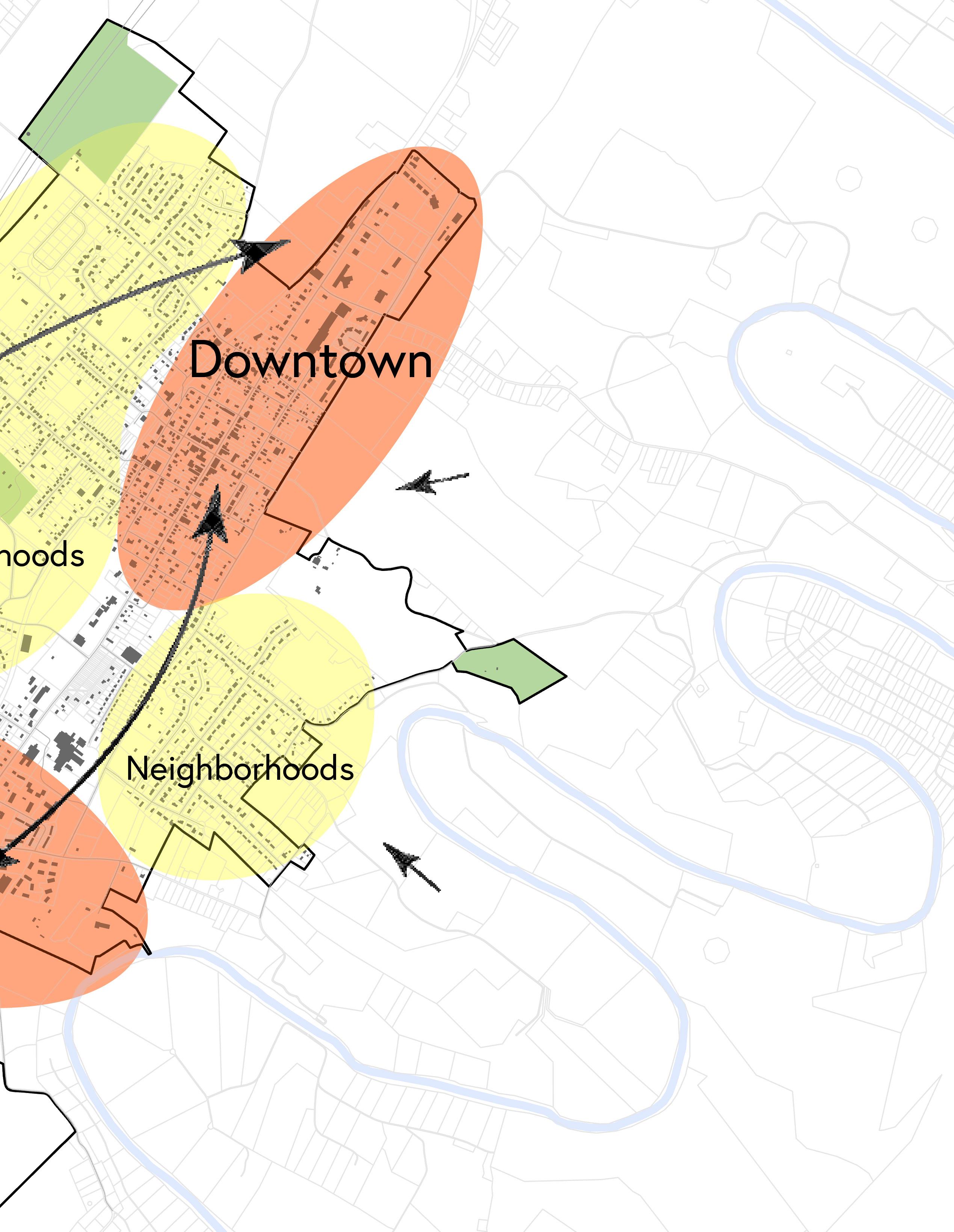
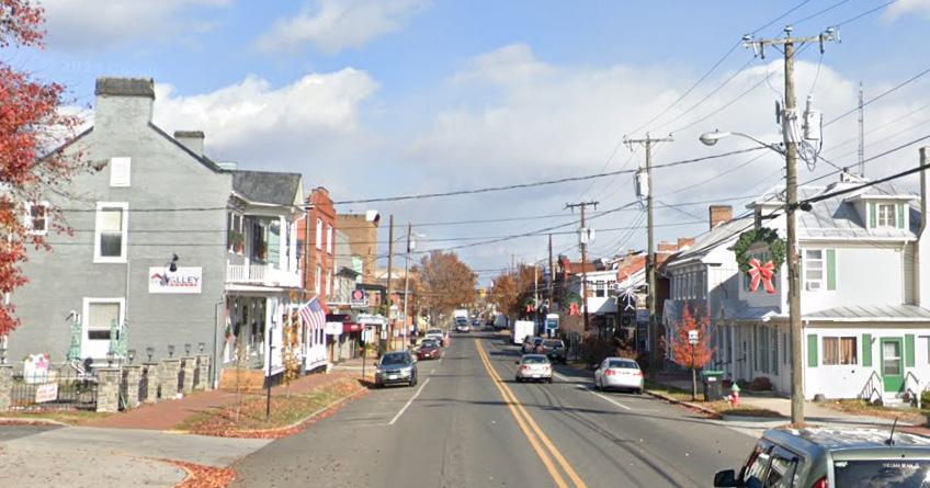
1. Weave Activity Centers Together
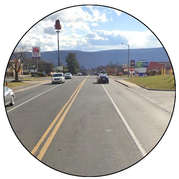
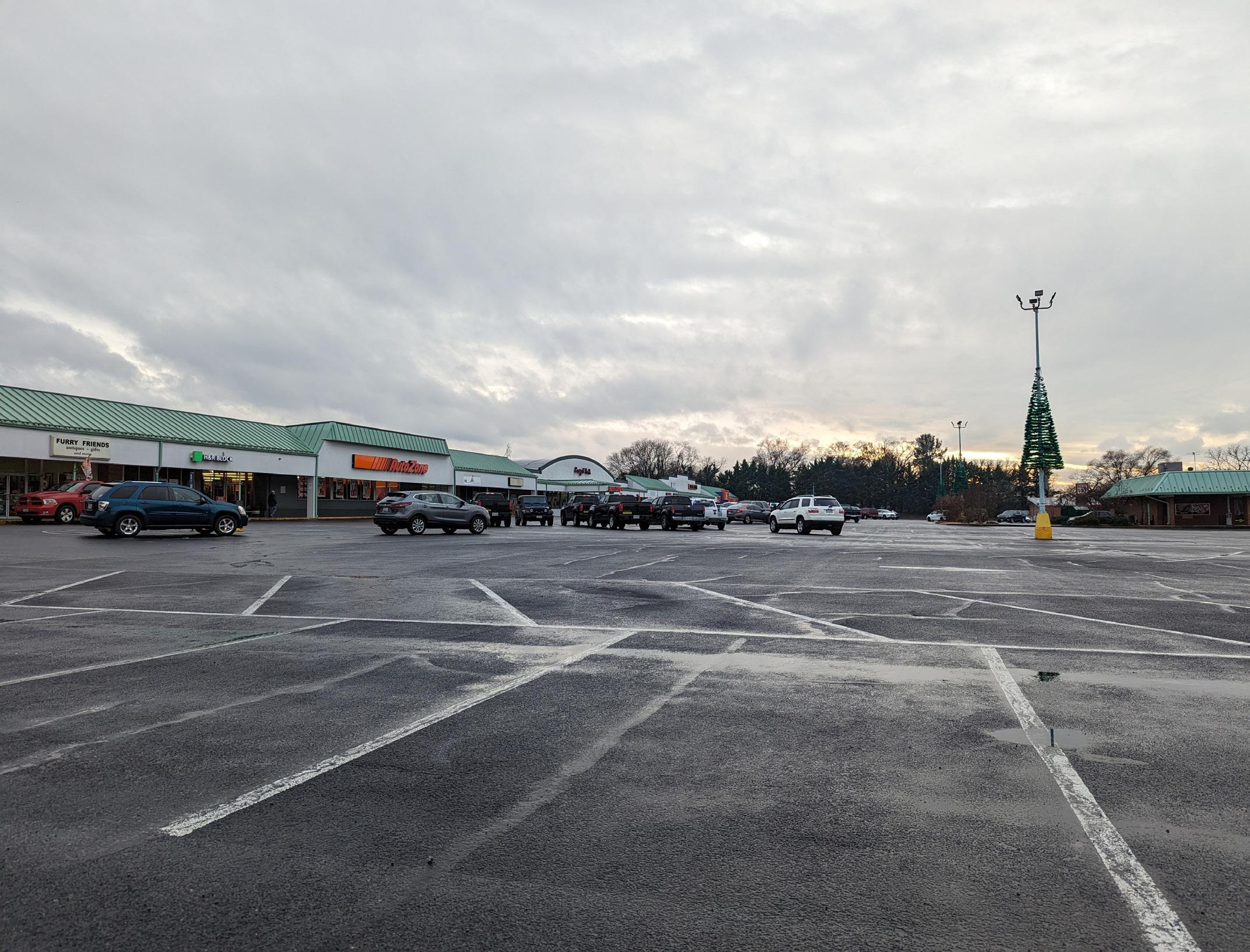
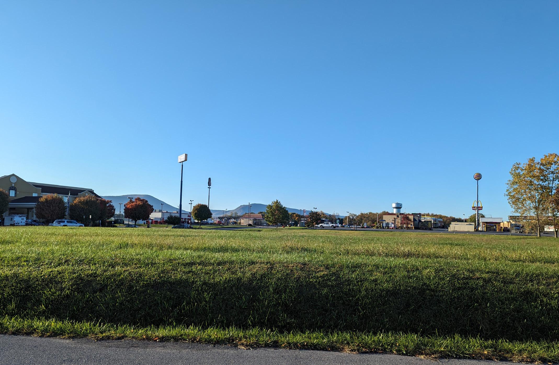
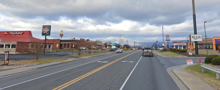
If one were to mention Woodstock, it would likely bring the mental image of its downtown. However, the community knows that Woodstock’s boundaries extend further than the historic downtown area. The exit off of Interstate 81, along Reservoir Road, features a road lined mostly with national chain restaurants, hotels, “big box” stores, and other businesses. Here, activity is intense and busy, mostly within vehicles. These businesses are open for long hours, offer many employment opportunities, and provide food and services to the Town’s residents. This comes at some cost to the community. Although there is a tax benefit to the Town’s revenue much of the business profit produced goes up and out to a national corporation rather than staying and circulating within the community. Additionally, although covering the entirety of the Town’s geography on foot or bicycle is possible, the character of this “autocentric” area is generally unsafe, for pedestrians or bicycles. The Town’s adopted Bicycle & Pedestrian Master Plan seeks to remedy this situation, making strategic alignment with the Comprehensive Plan important to ensure that land use decisions are supporting investment in the transportation network and vice versa.
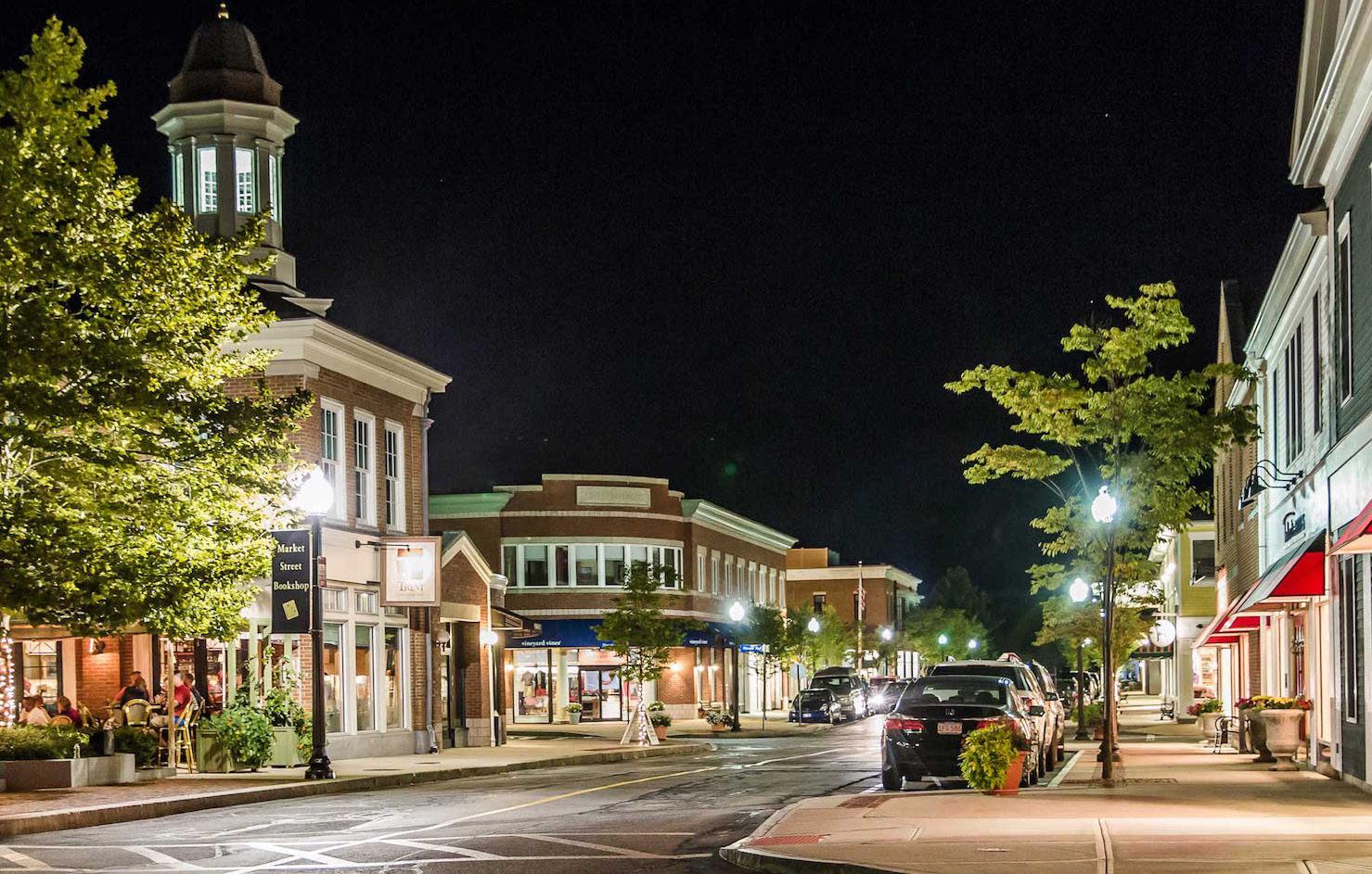
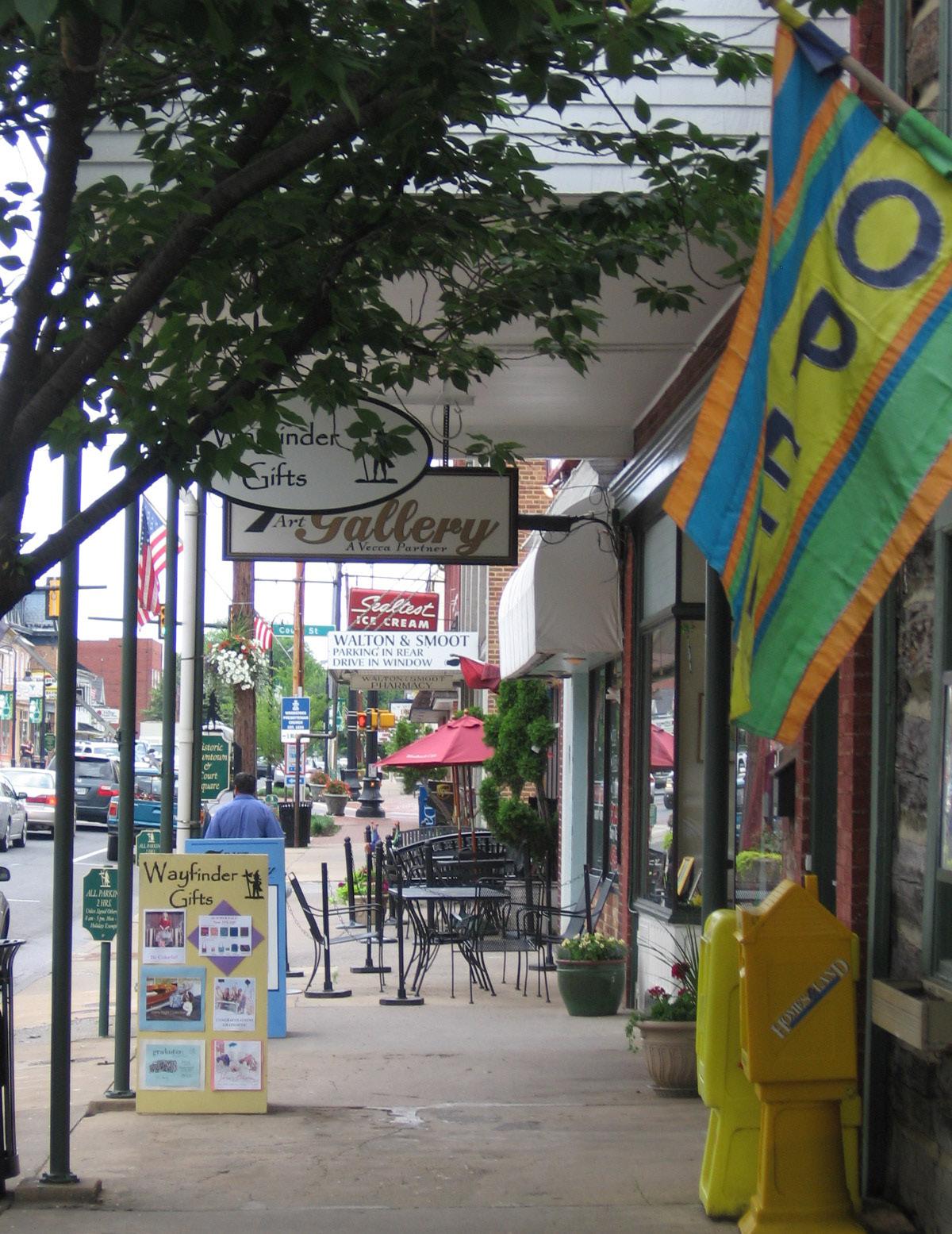
Downtown Woodstock is the charming center of the community, and where the original blocks were planned and formally chartered in 1761. Some of the businesses are alive around lunch or dinner time, but it is otherwise activity is generally sparse in the area. However, during events the area becomes crowded with many locals and visitors. Compared to Reservoir Road, the streets do not have as much activity. In the public engagement process, Woodstock residents expressed a strong desire for more restaurants and a lively atmosphere downtown. Community members also noted that, although there is signage, it seems difficult to attract people off of the interstate and into the actual historic core of the Town.
One “big idea” of the Plan is to unite key centers of activity together so that from border to border, Woodstock is a lively and comfortable place to live in and get around. This requires coordination between two parts of the Comprehensive Plan, although there are many steps to take to “weave together” these areas, specifically the Land Use and Mobility sections of the Comprehensive Plan. First, land use policies should be adjusted so that of varying types of businesses and houses can be mixed, where desired.
The Park
Currently, Woodstock has two distinct centers with very different feels and infrastructure. While a balanced town often includes different areas with diverse opportunities, weaving these areas into a more cohesive fabric can actually create a greater “small town feeling” while also having more businesses and places to live in closer proximity to one another. The Goals and Objectives in this document help adjust land use policies to see more high quality development projects are realized.
“Euclidean Zoning” is the historically recent way communities have regulated land use.
• Introduced a century ago to separate noisy, dirty factories from residents. Since then, it has been overused.
• Today it causes traffic congestion, decline in community cohesiveness and character.
Today, communities are reverting back to a “Mixed Use Zoning” approach.
• Allows uses in closer proximity together.
• More walkable design.
• Different types of housing allowed.
Mobility
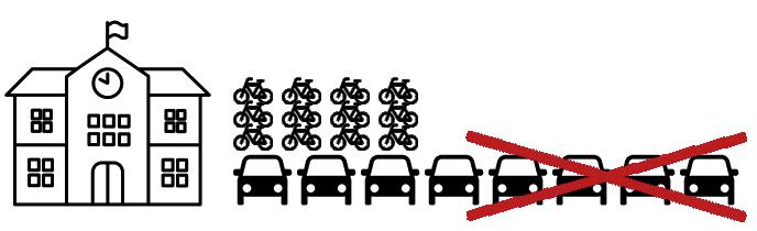
In the 24 hours of every day, most people have to work eight hours, attempt to get eight hours of sleep, and then have eight hours for “everything else.” Those eight hours include your transportation to work or between errands and activities, daily chores, and whatever is left is time to spend on leisure, family, or whatever one enjoys! Regardless of health, or socioeconomic standing, we all have a 24 limit to our day. Unfortunately, the past century’s urban planning trends have caused us to spread out every destination we have to visit. The space between these places wastes time in traffic, requires an automobile which might be expensive or limiting to children, the elderly, or disabled, and disconnects the community from one another. While vehicles are currently the quickest and most convenient way to get around, if everyone makes the same choice to drive, there will not be enough space to move comfortably or safely. One well-known example is the challenge of school pick-up and drop-off times near Reservoir Road. What if the community were better connected and half of the students arriving in cars could arrive safely by bicycle? The inconvenience of completing the activity would be greatly decreased and the experience would make everyone much happier. This “savings” in time can be utilized for other things that, in turn, are more enjoyable, thus leading to a higher quality of life. The Town’s other projects, such as the Rail to Trail and the Bicycle-Pedestrian Master Plan, also help implement this “big idea.”
One parking space can fit either a single car or up to 20 bikes!
2. Build on Woodstock’s Foundation
The Town’s currently active planning documents anticipated growth expanding the community’s borders through annexations of Shenandoah County. “Planned Unit Developments,” with some commercial components and new housing subdivisions would be how the Town accommodates people moving to the area. This strategy is in line with previous decades thinking that created the Woodstock we see today. From the area of the original charter, the Town expanded westward to accommodate new patterns of suburban residential and commercial development. With the addition of automobiles, these distances became greater and greater.
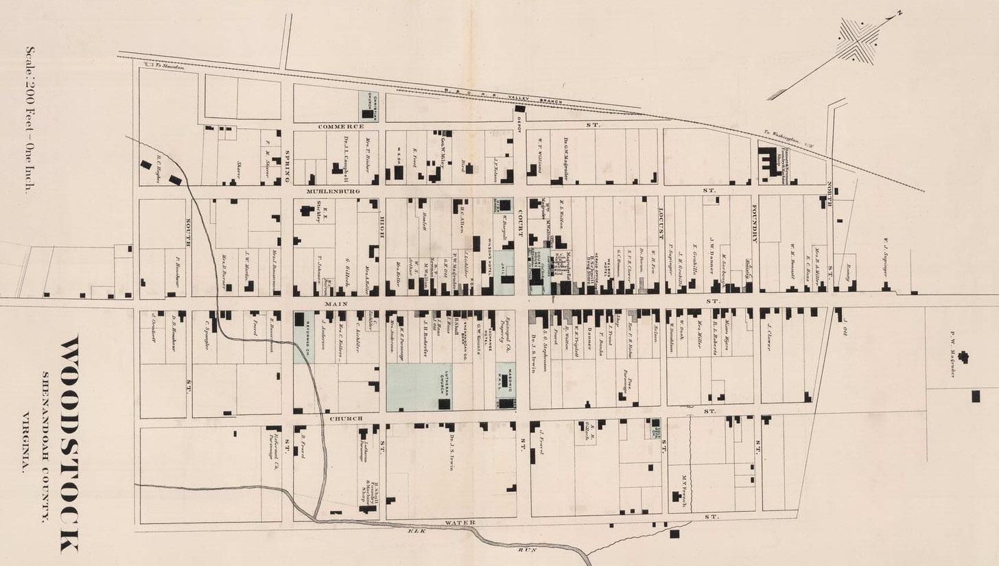
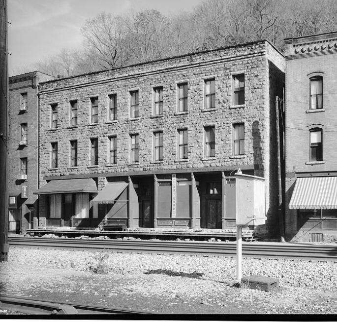
Woodstock’s original plat created a street grid that created blocks extending from Foundry St. to Spring St. bisected by the Great Wagon Road as “Main Street.” A map from 1878 shows that the extent of the Town had not expanded far outside these original boundaries, with a dense number of buildings fronting Main Street much like today, with the local railroad depot at the end of Court Street.
Grid-like, dense, mixed-use form of Woodstock in 1878.
Through the 1900s, however, the passenger rail system declined, bicycles were briefly invented and made popular, then automobiles continued to grow in use, the highway system was created, and numerous other social and technological advancements continued to push Woodstock outside of its historic boundaries. However, modern life’s benefits also come with increased demands and burden on infrastructure for energy or transportation, natural resources, wastewater treatment, and internet access. As this demand and burden continues to increase, communities around the United States have generally pursued the same patterns of growth and development to move into the future.
Downtown Woodstock was not so crowded that its Town boundaries needed to be expanded! New technology and cheaper housing construction methods allowed for the neighborhoods surrounding the historic centers of communities across the United States. With acres of available land surrounding them, American communities historically grew by annexing new areas of land and attracting new businesses with new roads to access them. Particularly with the creation of Interstate 81, which bisects Woodstock, and the rise of strip commercial and fast-food restaurants, the Town would seek to improve quality of life through the creation of new neighborhoods and shopping areas, and fiscally balance the cost of the infrastructure extending out to the new growth by preparing the next area of land for expansion, but this development model will not work in the future.
If we continue to look at development as a “linear progression,” we ignore exponentially increasing costs and the challenges to this growth model quickly add up. New roads, water, and sewer systems are very expensive. Locating grocery stores in an area that is too far to walk, and then making the way there unsafe to walk, means that everyone will make the same decision to drive around the same times of day, creating traffic that pollutes the air and water, creates noise, and is potentially unsafe to both drivers and other transportation modes. Modern schools and office facilities often demand ever larger parking lots to keep up with students, faculty, and worker needs. Collectively, across the country, we have taken all the activities that used to create active and vibrant streets and spread them out further and further in search of an “equilibrium” that is unobtainable by the development pattern’s design.
This Comprehensive Plan seeks to refocus Woodstock’s attention inward rather than outward. By looking for incremental opportunities for redevelopment and infill development of vacant parcels, the Town can develop in a way that maintains its charming, sociable character. There is a new moment in growth and development trends, where companies, visitors, and new residents are looking to live in walkable environments. Fortunately, this pattern of growth has already existed historically; we just need to get back to the development rules that made this a charming community in the first place.
Simply stated this big idea of the Comprehensive Plan seeks to:
Keep the Town fiscally sustainable by using infrastructure investment more efficiently, encouraging compact growth, rather than sprawl that increases maintenance costs.
Allow development in the historic patterns and forms that produced many of Woodstock’s favorite buildings that now contain well enjoyed businesses.
Protect the rural landscape and preserve agricultural uses surrounding Woodstock by focusing growth and development inward rather than outward.
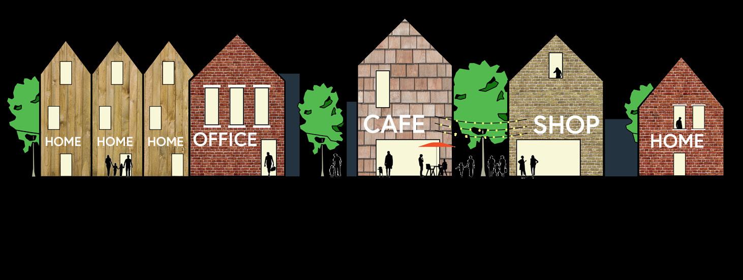
3. Foster High Quality Spaces
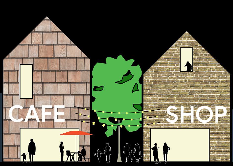
Woodstock needs more spaces. Spaces for new restaurants, shops, or offices to open up. Spaces for young families or single individuals. Spaces for the elderly and for children. However, not all development is of the same quality. The Town’s own regulations and rules, like many communities, are full of requirements such as setbacks or buffer yards that push different buildings away from one another and prevent building shared value. The idea here is that higher quality spaces can be achieved when there are more uses in proximity to one another, like the historic buildings on main street. When a building is only used for one purpose and requires too much parking and driving around it, the ability to build shared value is lost.
The design of individual buildings and their relationship to the other buildings along a street create the immediate sensory experiences, possibilities for interaction, and effectiveness at creating a lively atmosphere. Often, people look at main streets around the United States and notice that the buildings are historic. Intuitively, one might equate the ornamentation and architectural style typical of 1800s to early 1900s buildings with why the street is so attractive. However, while ornamentation is often interesting or beautiful, it is the actively used proximity and diversity of functions along the street that makes it more attractive. There are also physical features of the architecture that contribute to its attractiveness, regardless of architectural style, such as windows, porches, large windows in storefronts, informal outdoor seating spaces, and others. Awnings or siting buildings in response to wind or solar patterns can also enhance the experience of walking down the street by providing shade or protection as needed.
While the first big idea focused on weaving activity centers in Woodstock together and connecting them with infrastructure and the second focused on building on the foundation rather than looking outward, this big idea is focused on the physical layout and architectural features of buildings that create the atmosphere Woodstock’s community members have expressed their desire for.
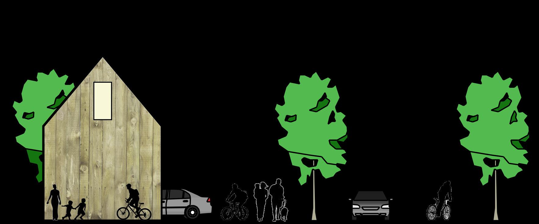
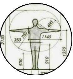
The Human Scale
The basic definition of the human scale is that objects in the environment are scaled to a size and shape that is tailored to the size of the average human body. When we compare areas such as Reservoir Road and Woodstock’s downtown, there is a clear example of architecture and design that is either scaled for automobiles and viewing the world through car windows, or for engaging pedestrians. Studies in the field of Environmental Psychology have sought to document the impacts of our built environment on our health, often finding that unsafe and unengaging environments raise people’s stress and anxiety levels. Therefore, it is important to build in ways that are scaled and conducive to the community’s health.
Average human size should influence architecture, planning, and design.
Scaled for automobiles with wide distances, limited opportunities, and large signs.
Scaled for pedestrians with many small details and opportunities.
Twelve Quality Criteria
How can we define what makes a “high quality place” from a “low quality one?” The renowned Danish urbanist Jan Gehl was one of the first researchers, in the 1970s, to study the built environment and categorize all characteristics that attract people. This was at the same time communities were building wide roads and separating all land use functions, such as residential and commercial areas. Today, many communities have realized the benefits of mixed uses and better design that follows historical patterns and are seeking to return and improve on how to build with higher quality.
High quality spaces exhibit all of the criteria below, regardless of where they are in the world. How much of the criteria do different areas of Woodstock meet? By identifying which of the criteria is missing, the Town can begin to work on improving the area. New development can also be assessed for its contributions towards meeting the various criteria.
PROTECTION AGAINST TRAFFIC AND ACCIDENTS - FEELING SAFE
• Protection for pedestrians
• Eliminating fear of traffic
OPPORTUNITIES TO WALK
• Room for walking
• No obstacles
• Good surfaces
• Accessibility for everyone
• Interesting façades
OPPORTUNITIES TO SEE
• Reasonable viewing distances
• Unhindered sightlines
• Interesting views
• Lighting (when dark)
SCALE
• Buildings and spaces designed to human scale
PROTECTION AGAINST CRIME AND VIOLENCE - FEELING SECURE
• Lively public realm
• Eyes on the street
• Overlapping functions day and night
• Good lighting
OPPORTUNITIES TO STAND/STAY
• Edge effect/attractive zones for standing/staying
• Supports for standing
OPPORTUNITIES TO TALK AND LISTEN
• Low noise levels
• Street furniture that provides “talkscapes”
PROTECTION AGAINST UNPLEASANT SENSORY EXPERIENCES
• Wind
• Rain/snow
• Cold/heat
• Pollution
• Dust, noise, glare
OPPORTUNITIES TO SIT
• Zones for sitting
• Utilizing advantages: view, sun, people
• Good places to sit
• Benches for resting
OPPORTUNITIES FOR PLAY AND EXERCISE
• Low noise levels
• Street furniture that provides “talkscapes”
OPPORTUNITIES TO ENJOY THE POSITIVE ASPECTS OF CLIMATE
• Sun/shade
• Heat/coolness
• Breeze
POSITIVE SENSORY EXPERIENCES
• Good design and detailing
• Good materials
• Fine views
• Trees, plants, water
Source: Gehl, Gemzøe, Kirknæs, Søndergaard, “New City Life,” The Danish Architectural Press, 2006. Further developed: Gehl Architects - Urban Quality Consultants, 2009.
Figure 14. Twelve Quality Criteria
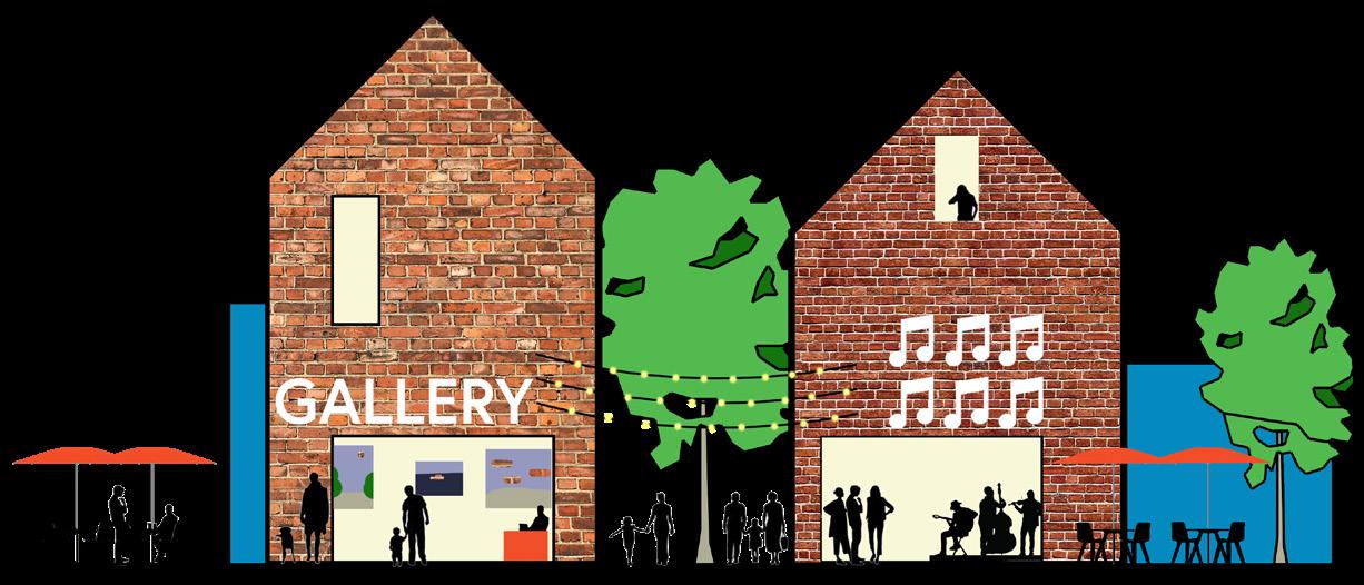
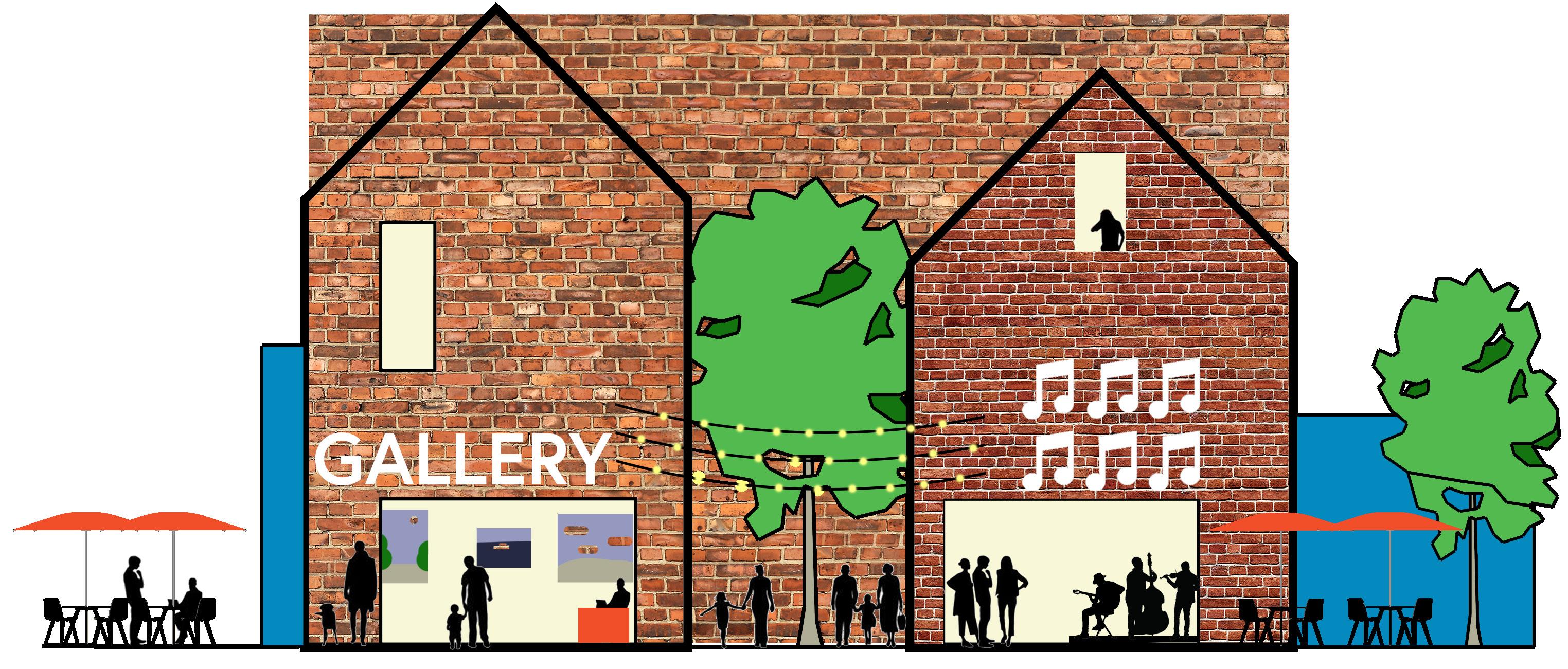
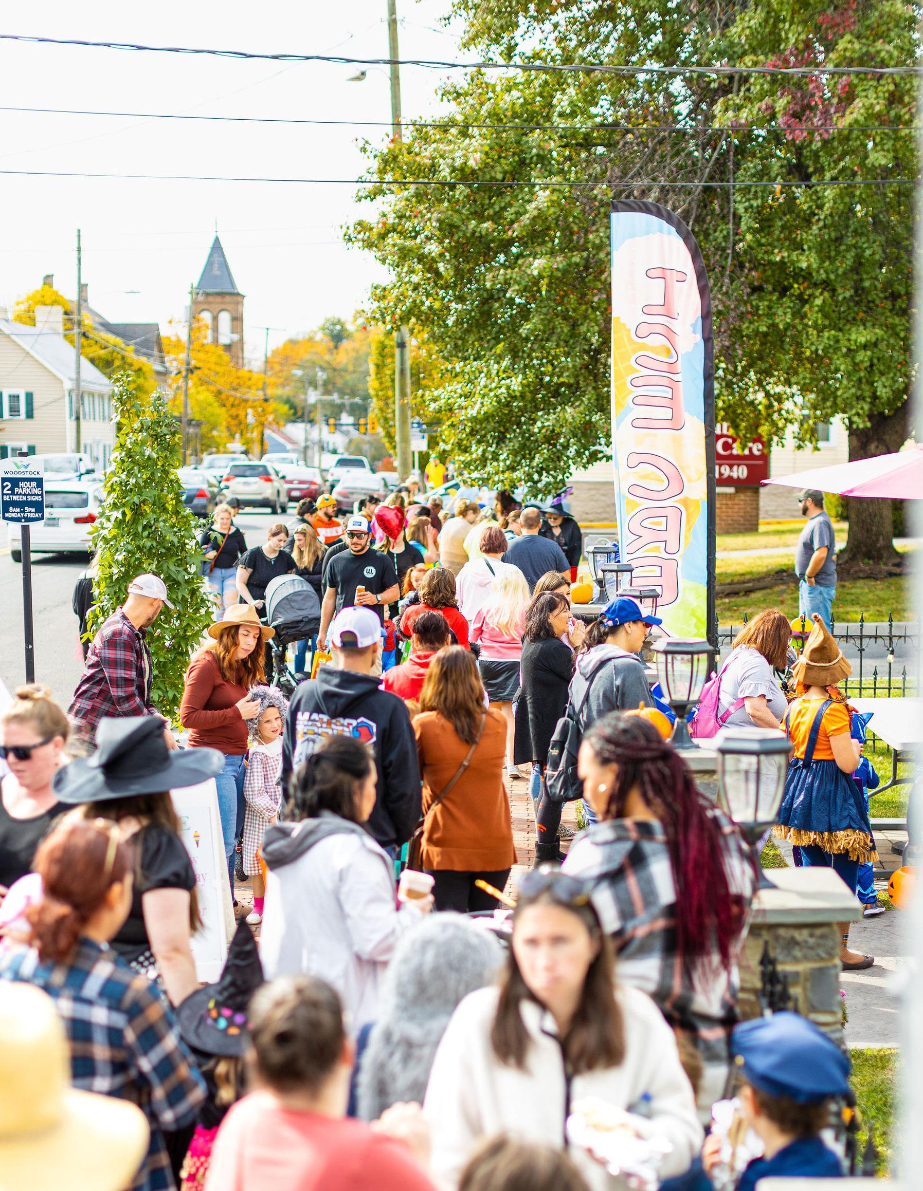
4. Activate Woodstock!
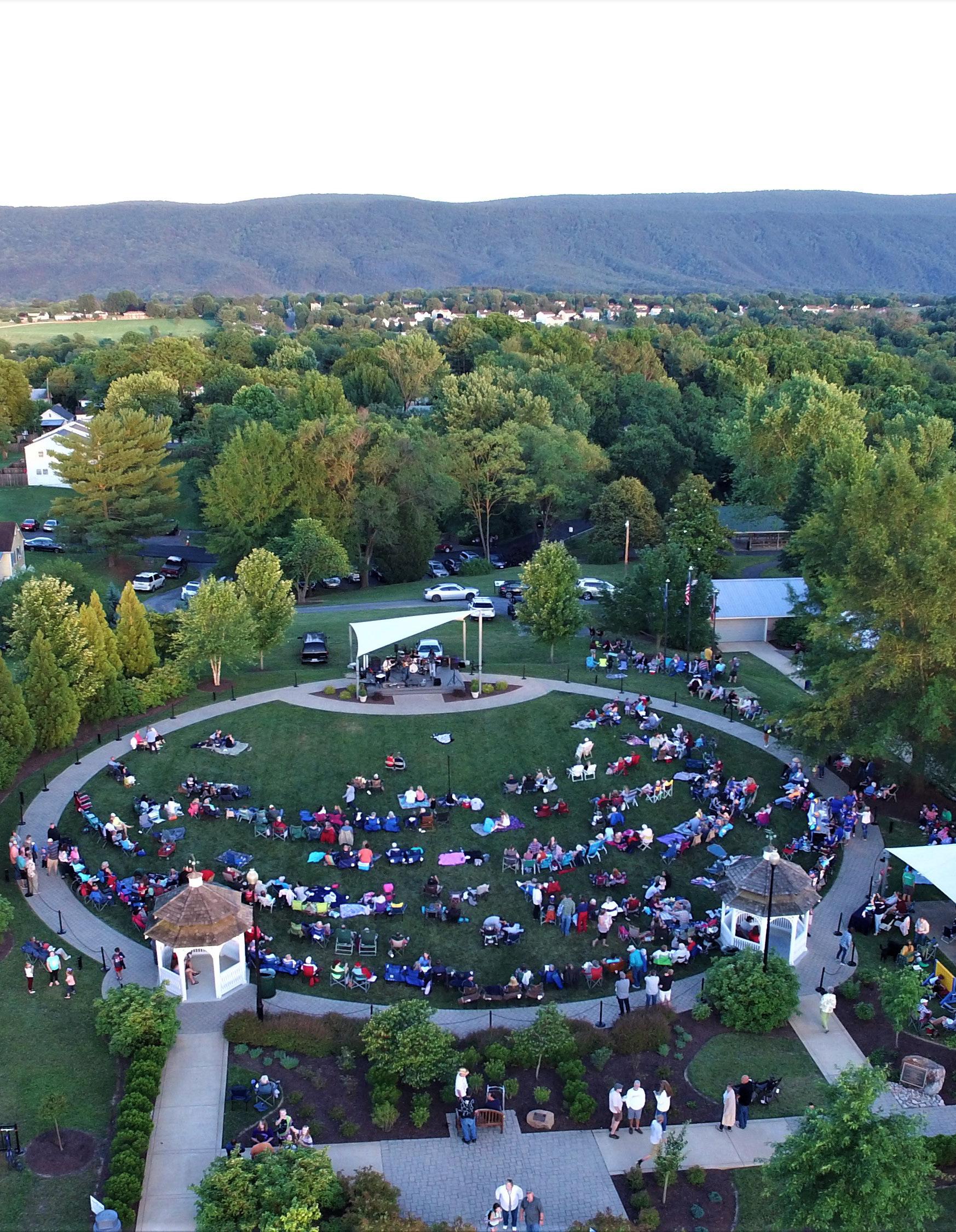
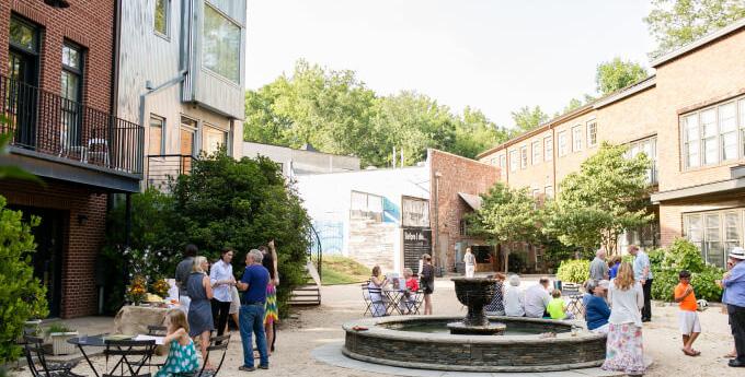
Through the community engagement process, Woodstock community members of all ages expressed a desire for various activities. While some ideas for this Plan, like a new community center, will require a long time with a high level of investment, other ideas like a “roller rink” came up. Building a roller rink may take time as well, but what if Town Hall’s parking lot were transformed into a temporary roller rink for a weekend? With some decorations, lights, and a sound system with music set up, the Town could put on yet another fun event for its residents to enjoy.
The Town is full of unlikely spaces that can serve as potential social infrastructure, it just takes some experimenting and creative ideas. Woodstock has a strong sense of “place.” Sense of place is the mental and emotional connection with a geographic location. The Shenandoah Valley and its Towns are unmistakable in their identity and community spirit, however, to even further maximize the shared value of being in or a part of Woodstock, the Town can create a formal “placemaking program.”
Beautifying the Town through landscaping, signage, banners, and other materials are ways the Town currently helps increase sense of place. However, creating a diverse amount of activities and temporary uses, new seating and gathering areas, or new public art, are all ways that the Town can invite its citizens to take ownership and stewardship of new areas.
Teenaged students specifically responded in the survey that they do not necessarily go to the Town’s parks or feel that event programming in the community engages them. By partnering with the schools and setting aside space or resources to allow for “pilot projects” of creative installations or events, the Town can begin to engage its young people and test ideas that might make them feel more included. Likewise, this can be repeated for elderly members of the community as well. Woodstock has many great local organizations and involved community members to collaborate with to ensure that events or new installations are produced with high quality.
Part of achieving this big idea to activate Woodstock requires ensuring that the Town is not getting in the way of its own success. The Zoning Ordinance and other development standards need to be assessed to ensure that activities, games, new seating areas, food or retail vendors, and other temporary uses are legally able to locate around Town. With a “lighter footprint” than a formal brick and mortar development, the Town can diversify opportunities in various locations and test what works with lower risk and investment. Other uses, such as pop-up kiosks for young entrepreneurs, art galleries, or music venues, while thoroughly enjoyed by the community might be incredibly difficult to develop due to the Town’s ordinances. “Activating” Woodstock and bringing its streets to life will take flexibility, diversity, and creativity.
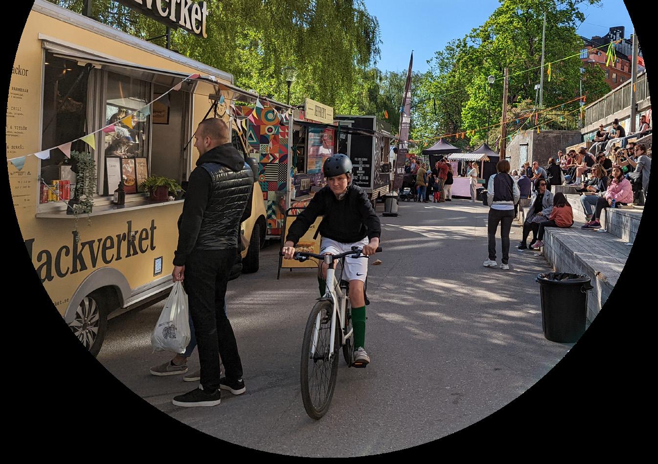
Events are an exciting part of life in Woodstock, regular pop-up markets can create predictable crowds to boost the local economy!
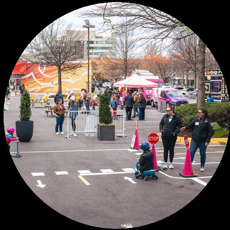
With some simple planters, tents, and picnic tables, a parking lot can become a new community space.
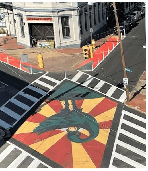
Paint can be used to make safer local streets as well as display public art.
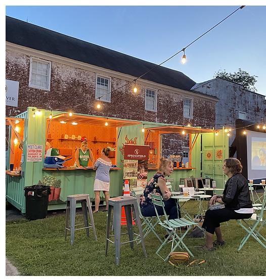
More substantial temporary uses, like a cafe, can be accommodated in shipping containers. Add some chairs and a movie screen and it becomes a perfect meeting place!
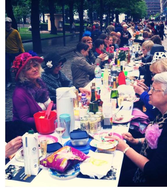
Creative events, like inviting all of Woodstock to dine at the same table for a night, can bring the community together.
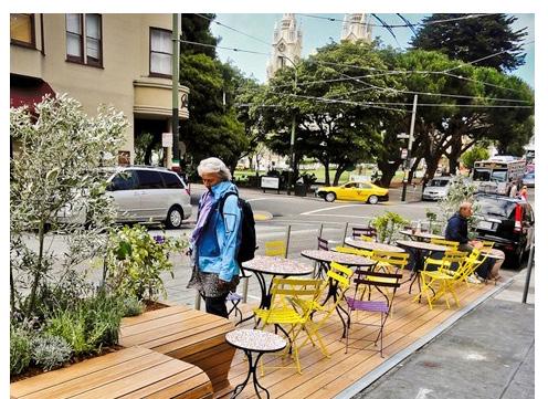
Parklets can help add more seating space for local businesses and extend the sidewalk, bringing more life to the street.
Land Use
Woodstock will efficiently utilize its land area to address the community’s needs for residential, commercial, and other uses to support a vibrant and sustainable local economy.
Overview
Woodstock’s previous Comprehensive Plan set the Town on a course that would grow into the countryside. If this path was continued, the agricultural landscapes that surround Woodstock would convert into subdivisions. As the Plan’s research shows, there is a great demand for more housing and commercial development in Woodstock, however, there is more than enough space within the Town to infill and redevelop properties to accommodate diverse types of housing without compromising the environmental and economic value of the agricultural landscape. This chapter focuses Land Use goals, objectives, and strategies into preserving the countryside while creating a framework for new growth inside the Town that delivers on what the community expressed a desire for; growth that brings new opportunities for retail, restaurants, or entertainment, but does not compromise the “small town charm” sociability that makes Woodstock’s community so special.
Internally, the Town features two distinct core areas that have very different characters, Reservoir Road is characterized by automobile-scale development and wide distances that the Town’s development ordinances have required over time. In contrast, the historic downtown was developed in a form that preserves walkability, offers many diverse uses of land mixed with one another, and is thought of as the “heart” of Town. Connecting these two areas, with transportation infrastructure and new development that offers interesting opportunities for employment or business, expands the built “fabric” of places to go and spend time in Woodstock.
By capitalizing on proximity to other uses, daily life in the Town can be made more convenient over time.
The previous Comprehensive Plan expected Woodstock to grow into an “urban growth area” over time, with new neighborhoods. This Plan preserves the agricultural economy in collaboration with Shenandoah County, and encourages growth inward rather than outward.
Existing Land Use
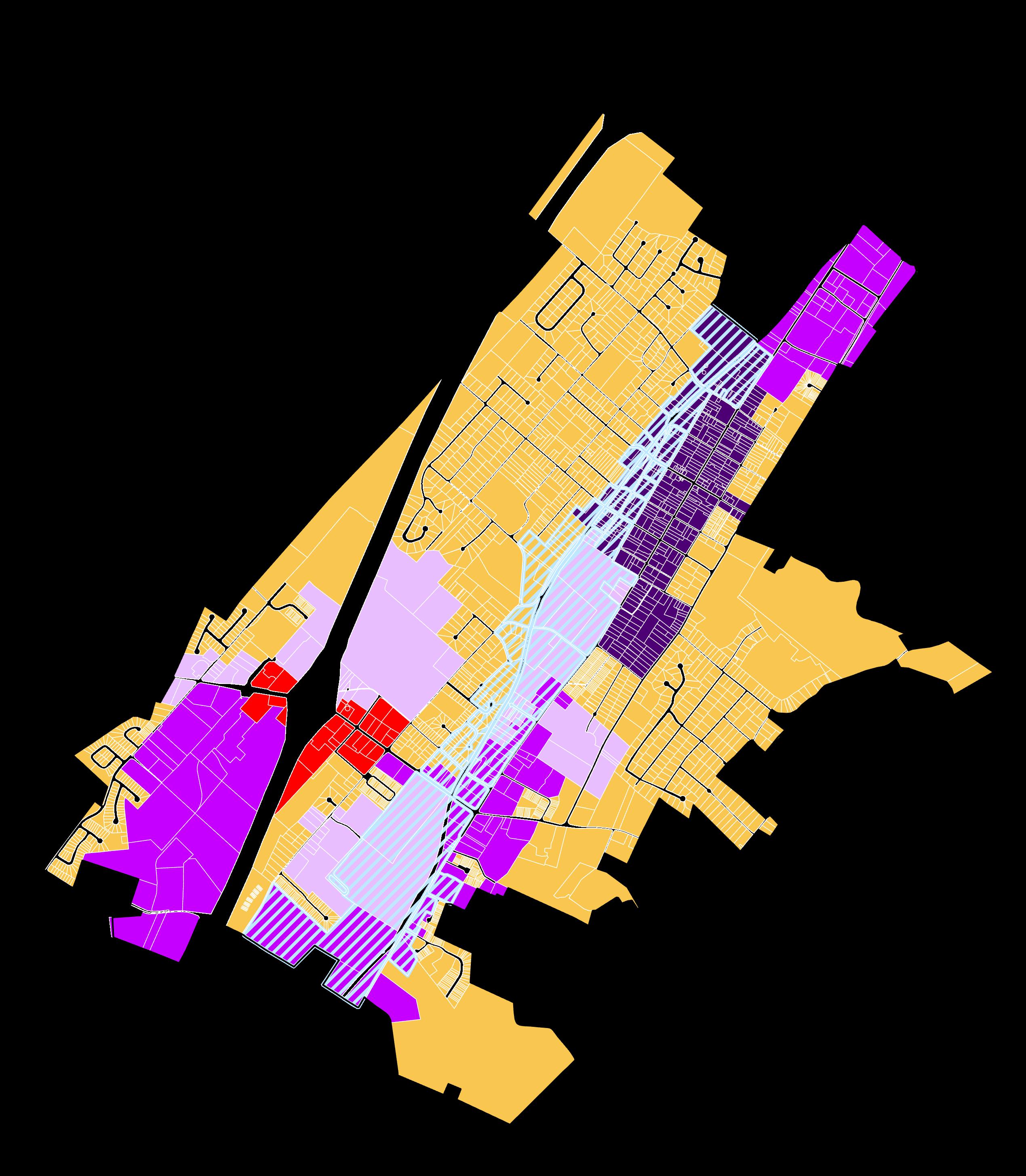
It is important to examine how Woodstock’s land is currently being used to ensure that it is efficient and productive. Efficiency and productive generally means that in areas where growth and development is planned, it is occurring as expected. A hypothetical example of “inefficient land use” would be if a historic commercial building in the downtown area was replaced with a self-storage business. Selfstorage businesses, while useful, are often “passive” meaning that they do not have a lot of people coming in or out of them like a restaurant does, meaning it is “inefficient” use of the land in that location along Main Street.
The Town and Shenandoah County’s previous planning documents show a potential growth area that greatly exceeds Woodstock’s existing boundaries. However, Woodstock still has a large amount of land that is currently undeveloped for any use. There are also aging shopping centers that could be redeveloped to add other uses, such as new apartments, rather than remaining solely commercial.
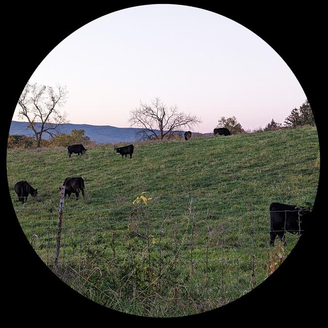
One of Woodstock’s assets for tourism is the beauty of the natural countryside, and the local economy is also fortunate to have active farms directly adjacent to the Town’s boundaries. If these farms were subdivided and converted into residential units, the cost to supply and maintain sewer and water infrastructure outside of Town boundaries will eventually hurt the Town’s finances as well as erode the “small town charm” character that residents express their enjoyment of.
Woodstock Shopping Center’s parking lot.
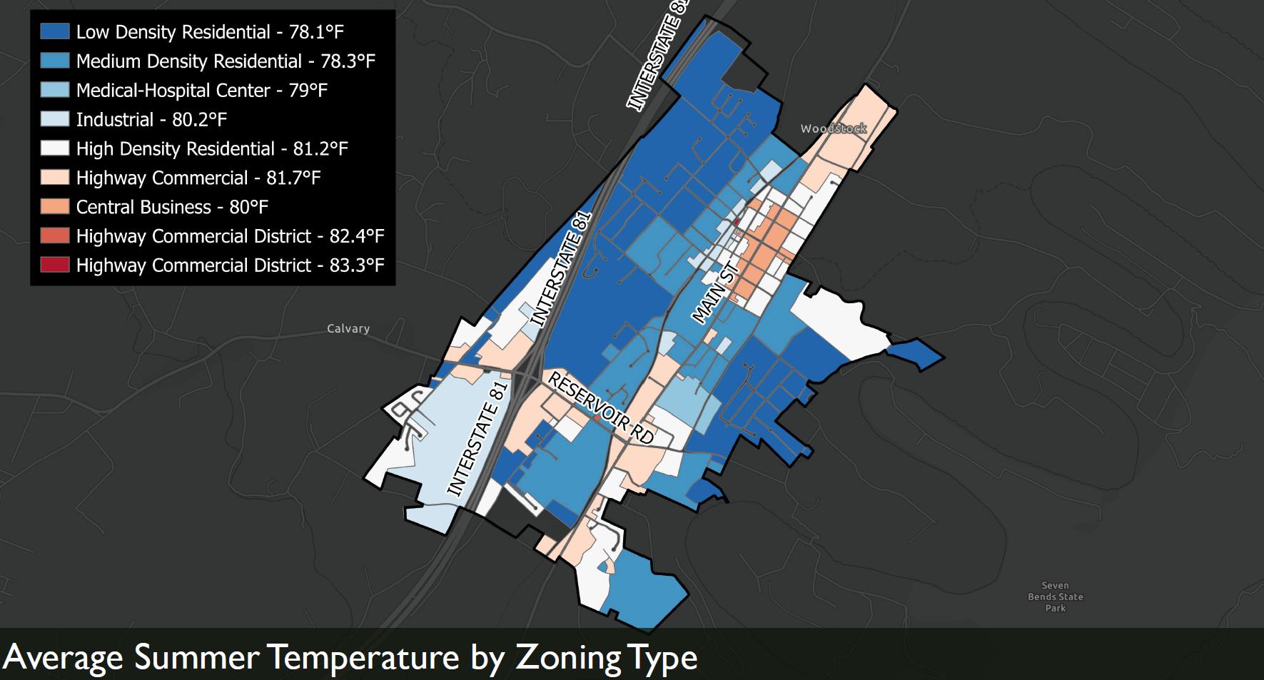
Figure 15. Existing Land Use Map
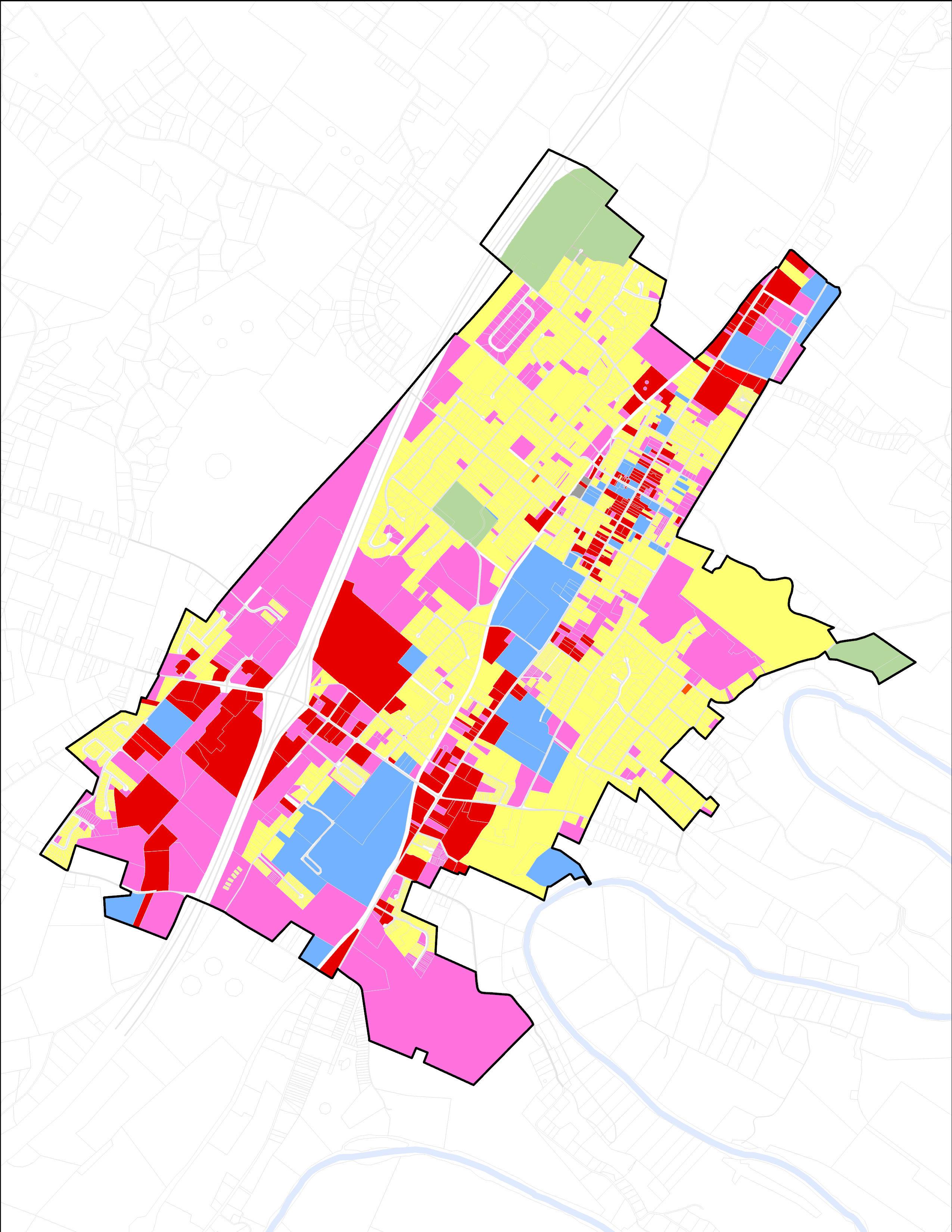
Existing Zoning
Zoning regulations are laws that determine how land can be used in certain areas, as well as requirements for the form of development. Woodstock’s Zoning Ordinance outlines zoning districts, each of which has its own regulations for uses, structures, landscaping buffer areas, setbacks, or other requirements.
The majority of Woodstock is currently zoned R-1 for low density residential. There are several areas with R-2 and R-3 zoning for general residential uses, including housing, schools, offices, and certain businesses at a higher density. There are several smaller areas in downtown and on major corridors that are zoned for business (B-1 or B-2). Several areas in the town are zoned for industrial uses, such as welding/machine shops, manufacturing, and meat processing or large footprint stores. Near the geographic center of town, there is a specific zoning district for the hospital center.
As Woodstock recommends changes in land use through the Comprehensive Planning process, updating the Zoning Ordinance is an essential step in implementing these changes. Most Zoning Ordinances throughout Virginia and the United States are full of outdated requirements from past decades that sought to put extensive controls on where development could go and what requirements it needed to follow. Historically, those controls were often designed to segregate higher income from lower income areas or white residential areas from black residential areas. Beloved shops in historic buildings could not be built today under current Zoning Regulations, due to parking requirements for instance. If the most loved parts of Woodstock were built in the past and are seen as the safest places to walk around and enjoy your time, why would a community want to make building in the same way illegal?
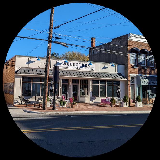
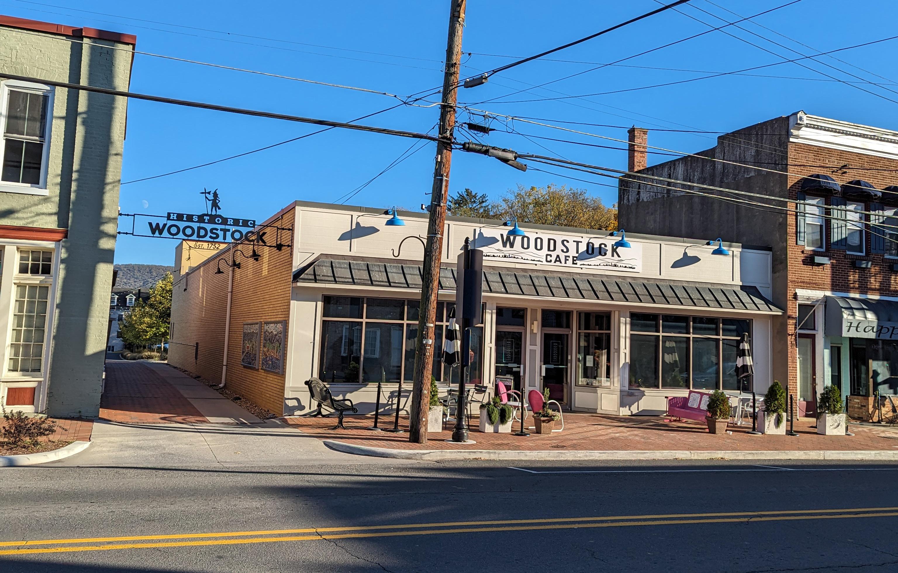
Woodstock Cafe, a popular business along Main Street.
Figure 16. Zoning Map
Undeveloped Parcels
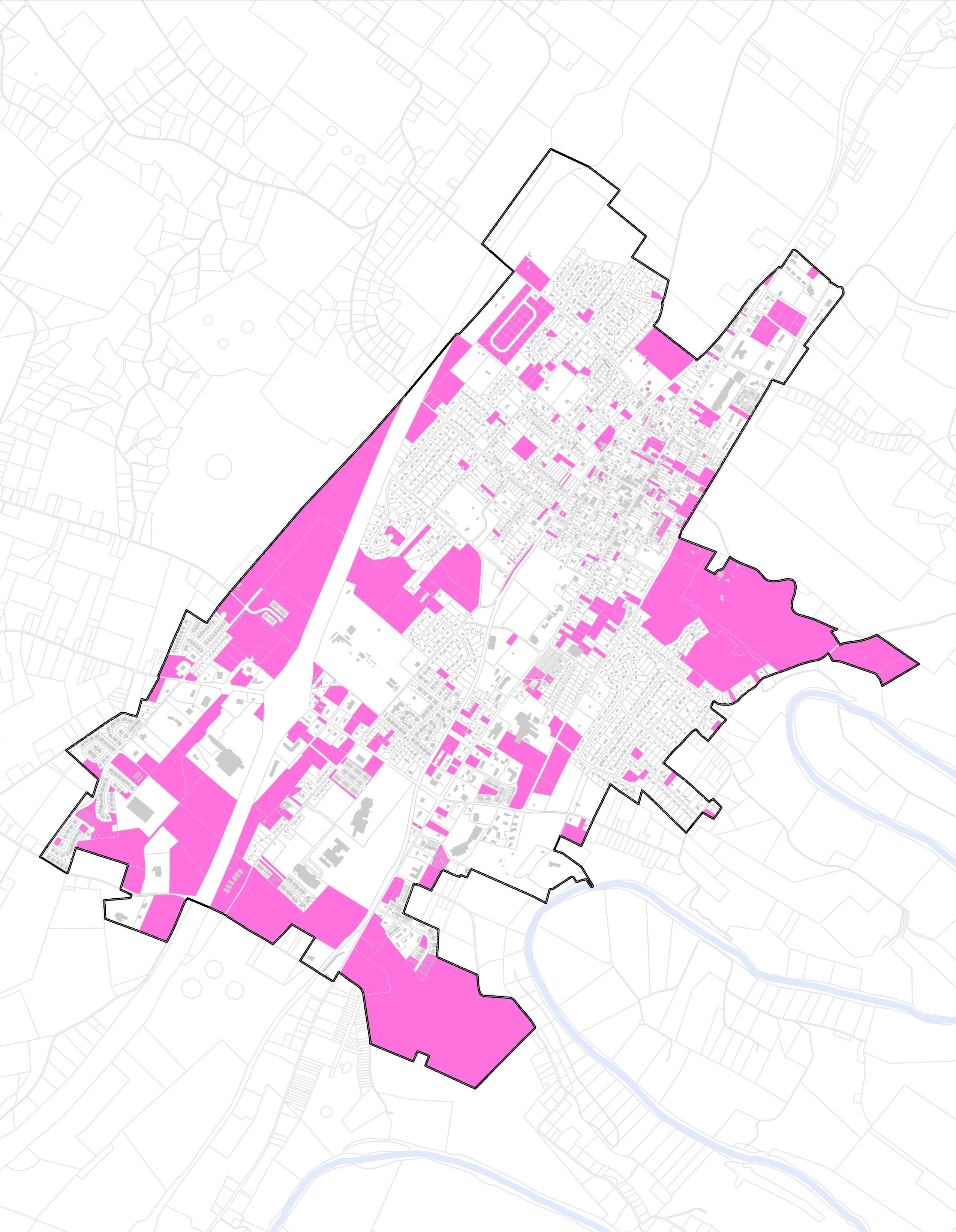
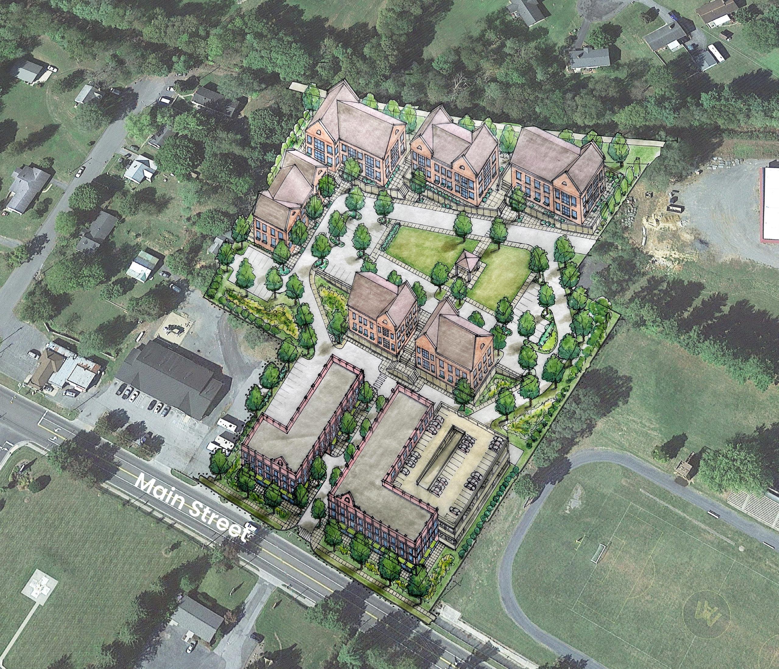
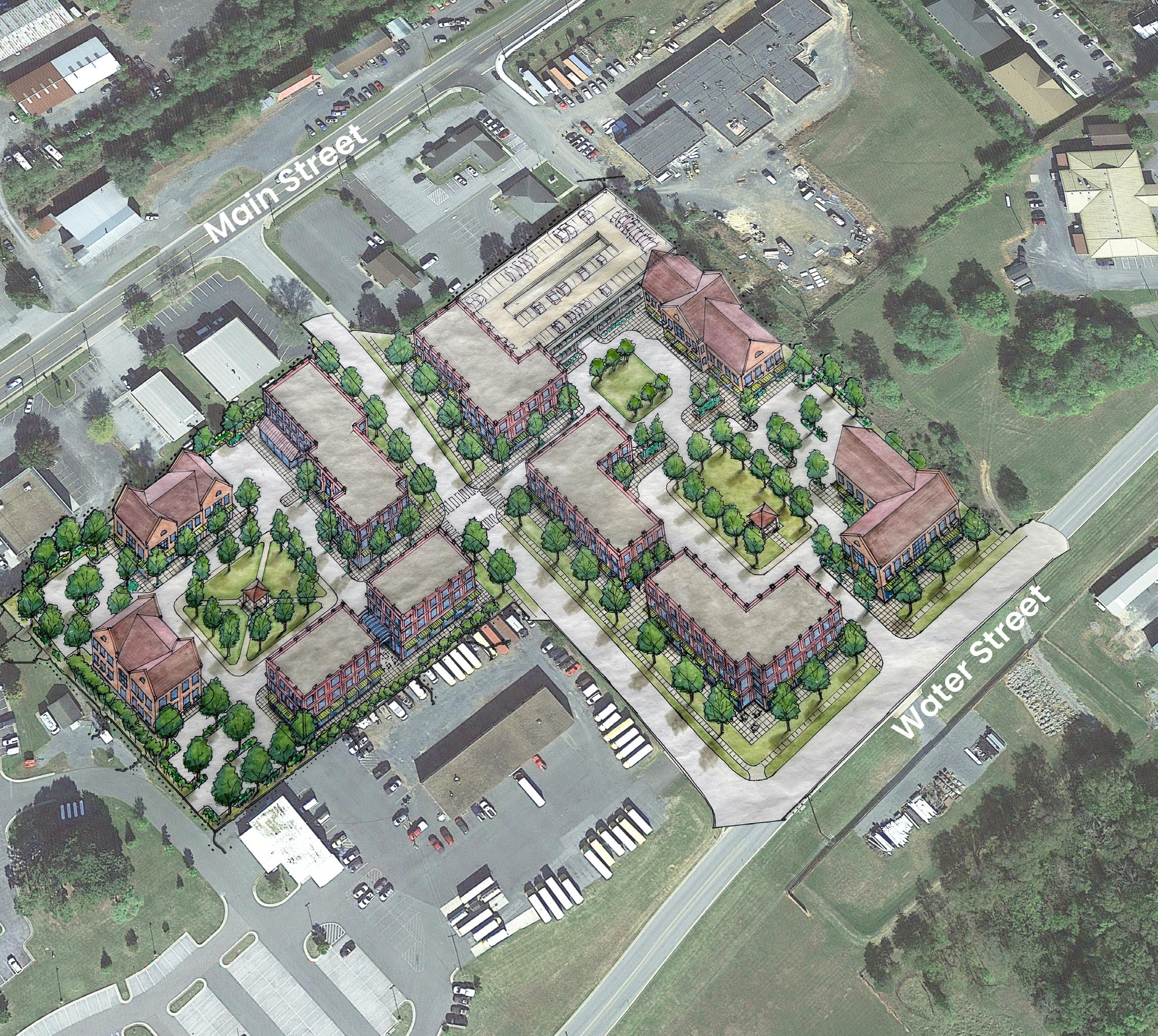
There are approximately 804 acres total of undeveloped, non-tax exempt, land available in the Town of Woodstock. While not all of this land is buildable for environmental reasons, it illustrates how much land is available within the Town’s existing borders that is not currently being utilized. This is important because Woodstock’s previous Comprehensive Plan identifies a large Urban Development Area outside of the Town’s boundaries and calls for dense, mixed use, Planned Unit Developments (PUDs) to provide the area with new housing and businesses. While an improvement over previous generations of singleuse sprawl, this type of development has similar issues of traffic generation, “placeless” aesthetics, and inefficient use of land. This Comprehensive Plan encourages the Town to look “inward” rather than outward by encouraging development along existing infrastructure. This allows the Town to provide services and utilities in a more economically sustainable and efficient manner.
Undeveloped parcels of land near West Reservoir Road.
Figure 17. Undeveloped Parcels Map
Subdivisions
The Town and County’s planning documents depict a future growth area that greatly exceeds the Town’s boundaries. While visually, the Town is surrounded by active farms and fields, there is a path forward towards subdividing these properties and converting them into residential uses. While new neighbors is a great asset for the County and the Town, the form of typical suburban subdivisions comes with many issues. Their design isolates them from the rest of the community and often makes the use of an automobile the only way to access daily needs. The more land is subdivided and developed, the more traffic is generated. Additionally, extending water and sewer utilities out to these subdivisions is expensive per foot compared to providing the same service to new development closer to the existing system. Suburban sprawl has been identified as a “placeless” or character eroding process of development proceeding to spread out of developed areas and encroaching on rural areas seeking cheaper land values and looking to market brand new homes to potential buyers. Today, it is recommended to mitigate these impacts by focusing on redevelopment of existing or vacant properties within a community before looking elsewhere for more land.
S. Water Street, where farming faces houses.
The previous Comprehensive Plan envisioned growth outward with new subdivisions, as shown below. The focus on this plan is to re-orient Woodstock’s growth inward, creating higher quality development and preserving the rural landscapes and agricultural economy surrounding the Town.
Figure 18. Previous Comprehensive Plan Growth Map
Goal 1: Implement changes to the Town’s land use regulations and make decisions in accordance with the Future Land Use map.
Objective 1.1 Audit and amend the Zoning Ordinance to fit the desired uses and character of an area, as determined by the Comprehensive Plan and the Future Land Use map categories.
Action 1.1.1 Allow for more diverse uses of land, encouraging vertical and horizontal “mixed uses” on various properties.
Action 1.1.2 Encourage infill of vacant and underdeveloped parcels of land with commercial and residential spaces.
Action 1.1.3 Allow for “gentle density,” increases of areas throughout Woodstock to incrementally increase the supply of housing. This can include accessory dwelling units (or “backyard cottages”), multifamily housing units, duplexes, or townhomes. Explore removing height requirements in favor of “stories.”
Action 1.1.4 Permit accessory commercial units, or small scale commercial spaces that allow for diverse retail or small scale non-nuisance creating manufacturing, such as to locate throughout Woodstock.
Action 1.1.5 Explore amending parking requirements from Woodstock’s ordinance. Consider the reduction or creation of “parking maximums” in areas where parking on-site is seen as required (such as Reservoir Road). Amend Section 90-387. - Off Street Parking - Generally. to greatly reduce the amount of required parking per use.
Action 1.1.6 Consider the future implementation of a Form-Based Code or revisions to the Municipal Code of Ordinances to promote different uses and varied housing types and densities, while maintaining the character of the town.
Goal 2: Weave together centers of activity with adjacent neighborhoods.
Objective 2.1 Amend the zoning regulations in residential neighborhood areas to allow for a mix of residential and commercial development outside of established cores where the market can support it to encourage connectivity between centers of activity.
Action 2.1.1 Amend parking requirements to ensure that new development in transitional areas between activity centers supports walkability by locating parking to the sides or rear, with buildings located closer to the street.
Goal
3: Improve the Reservoir Road center of activity through walkable design and a greater mix of residential uses.
Objective 3.1 Amend the Highway Commercial (B-2) District to reform all requirements that create unwalkable site designs. Create a new Zoning District more tailored to the I-81 exit to accommodate highway-oriented uses.
Action 3.1.1 Revise the “intent” of the B-2 district to better reflect its changing character into another important center of activity for Woodstock. The district name could be changed to reflect a more “mixed use” character.
Action 3.1.2 Revise the permitted uses to include apartments or other residential units.
Action 3.1.3 Amend district requirements to allow for more walkable site design, inter-parcel connections, and mixed uses. Consider buffering requirements that allow for “cut-through” sidewalks to adjacent residential neighborhoods.
Action 3.1.4 Encourage the redevelopment of excess parking areas into new active uses.
Action 3.1.5 Ensure that all related development standards are conducive to the ability to walk or bicycle safely and comfortably through the community.
Action 3.1.6 Encourage parking to be located in ways that do not inhibit pedestrian or alternative transportation access to the use.
Action 3.1.7 Create design guidelines for “big box” stores that encourage contemporary parking lot design and building architecture.
Objective 3.2 Collaborate with the Virginia Department of Transportation to ensure that the Town’s bicycle and pedestrian network is fully implemented and that new land uses are assessed for their ability to make the Reservoir Road area more walkable.
Action 3.2.1 Conduct further studies to ensure that students have a safe route to school by bicycle or on foot, particularly crossing West Reservoir Road.
Goal 4: Preserve the history of the area while enhancing the character of the Downtown center of activity to create more social and economic opportunities.
Objective 4.1 Amend the Central Business (B-1) District requirements to allow for a mix of residential and commercial development that enhances the walkability and use of the downtown area.
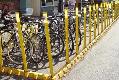
Action 4.1.1 Create provision in the Town code for bicycle racks and bus shelters for commercial uses.
Action 4.1.2 Amend district requirements to allow for more flexible siting of residential and/or commercial uses.
Action 4.1.2 Explore increasing the maximum building height and a set number of allowable “stories for more flexible architectural design, in keeping with the character of the district.
Action 4.1.3 Consider amending the requirements for accessory uses, structures, or buildings to allow for more varied uses.
Action 4.1.4 Explore the removal of off-street parking requirements in this district. Public parking supply adequately accommodates all needs and new public facilities can be constructed if necessary.
Action 4.1.5 Create suggested design guidelines for the downtown area that reflect high quality architecture and design.
Action 4.1.6 Revise the Code of Ordinances to require a percentage of a structure to be commercial, or street facing first floor use as commercial only in target areas. This could be achieved through an “overlay district” along Main Street with full residential use through Special Use Permits.
Objective 4.2 Amend or rezone areas of the High Density Residential (R-3) District to allow for a mix of residential and commercial development that enhances the walkability and use of the downtown area. Examples are included as actions below, but further revisions may be necessary.
Action 4.2.1 Increase the amount of permitted uses in the district to include neighborhood-scale commercial uses, such as restaurants or small shops.
Action 4.2.2 Amend district requirements to allow for more walkable site design, inter-parcel connections, and mixed uses as well as increasing the overall supply of housing. Revise requirements to allow for a continuation of the historic fabric found in the downtown area. Readdress height limits and set to a number of “stories.”
Action 4.2.3 Consider the removal of on-site parking requirements or change “shall” to “may” include up to two spaces for each unit.
Objective 4.3 Amend or rezone areas of the Industrial (I-1) District to allow for a mix of residential and commercial development that enhances the walkability and use of the downtown area. Examples are included as actions below, but further revisions may be necessary.
Action 4.3.1 Allow for the development of residential units of varying types as a permitted use in the district. Include the requirement that commercial spaces be developed as part of residential development.
Action 4.3.2 Revise the requirement that only one main building and its accessory buildings may be erected on a lot or parcel of land in this district to allow multiple uses on one property.
Action 4.3.3 Amend district requirements to allow for more walkable site design, inter-parcel connections, and mixed uses. Consider buffering requirements that allow for “cut-through” sidewalks to adjacent residential neighborhoods.
Objective 4.4 Identify underutilized or vacant properties that present redevelopment opportunities.
Action 4.4.1 Develop incentives or research and help advertise the use of grants and tax credits to assist in funding the redevelopment of underutilized or vacant properties.
Action 4.4.2 Use zoning enforcement methods to require vacant property owners to bring their properties in line with code, thereby encouraging owners to maximize usage of their property. Consider collaborating with the County on enforcing the Virginia Property Maintenance Code (VPMC).
Goal 5: Ensure that development is of high quality architectural design that contributes to its surroundings.
Objective 5.1 Develop and adopt design guidelines that promote high quality design of storefronts and shared community areas in new developments.
Action 5.1.1 Develop incentives or research and help advertise the use of grants and tax credits to assist in funding the redevelopment of historic properties.
Action 5.1.2 Consider the implementation of Form-Based Code to allow for different uses and housing types while maintaining the character of the town.
Goal 6: Collaborate with Shenandoah County and the Northern Shenandoah Valley Regional Commission to direct growth towards the Town, protecting the rural landscapes and agricultural economy.
Objective 6.1 Participate in the creation of a Transfer of Development Rights (TDR) and Purchase of Development Rights (PDR) program. Consider coordinating with land banking and management foundations or entities.
Action 6.1.1 Ensure that future land uses are complimentary to Shenandoah County’s Comprehensive Plan.
Economic Development
Woodstock will collaborate with Shenandoah County and regional partners to strategically develop a productive, vibrant, and diverse local economy that focuses on small business growth and gainful employment opportunities.
Overview
Woodstock is a center for employment and tourism for Shenandoah County and beyond. The Town will build upon its strengths by retaining existing and attracting new businesses to support residents and local entrepreneurs through with an ecosystem of goods, services, and well-paying jobs. By investing in infrastructure that supports housing and mobility in Woodstock, the Town will pursue additional employment opportunities through retail, small offices, workshops and studios, and other forms of employment. Woodstock will enable development by clarifying and reforming local land use regulations while investing in placemaking measures to grow shared value through proximity of local businesses.
The Town, through coordination with the local Economic Development Authority and other partners, will also seek out grant opportunities through the state and federal governments to retain businesses and attract new businesses to Woodstock. In doing so, the Town will also work with existing businesses directly to understand their needs and what challenges they may be facing. Woodstock will also seek to support and enhance food systems to address grocery needs and connect farmers with a greater customer base.
By implementing the Comprehensive Plan’s various goals, the “entrepreneurial ecosystem” of Woodstock will be enhanced, creating ample opportunities for the local community to benefit from employment or increased commercial opportunities. As the Town’s tax base diversifies, it will have more flexibility and ability to fund new projects that further improving quality of life and addressing the community’s needs. With an emphasis on local development and placed-based shared value creation, the Town will be able to pursue high quality economic development and site new projects into its vision for the future, rather than chasing opportunities from a “blank slate.” This will position Woodstock to be fully engaged and prepared for any future negotiations with clear expectations.
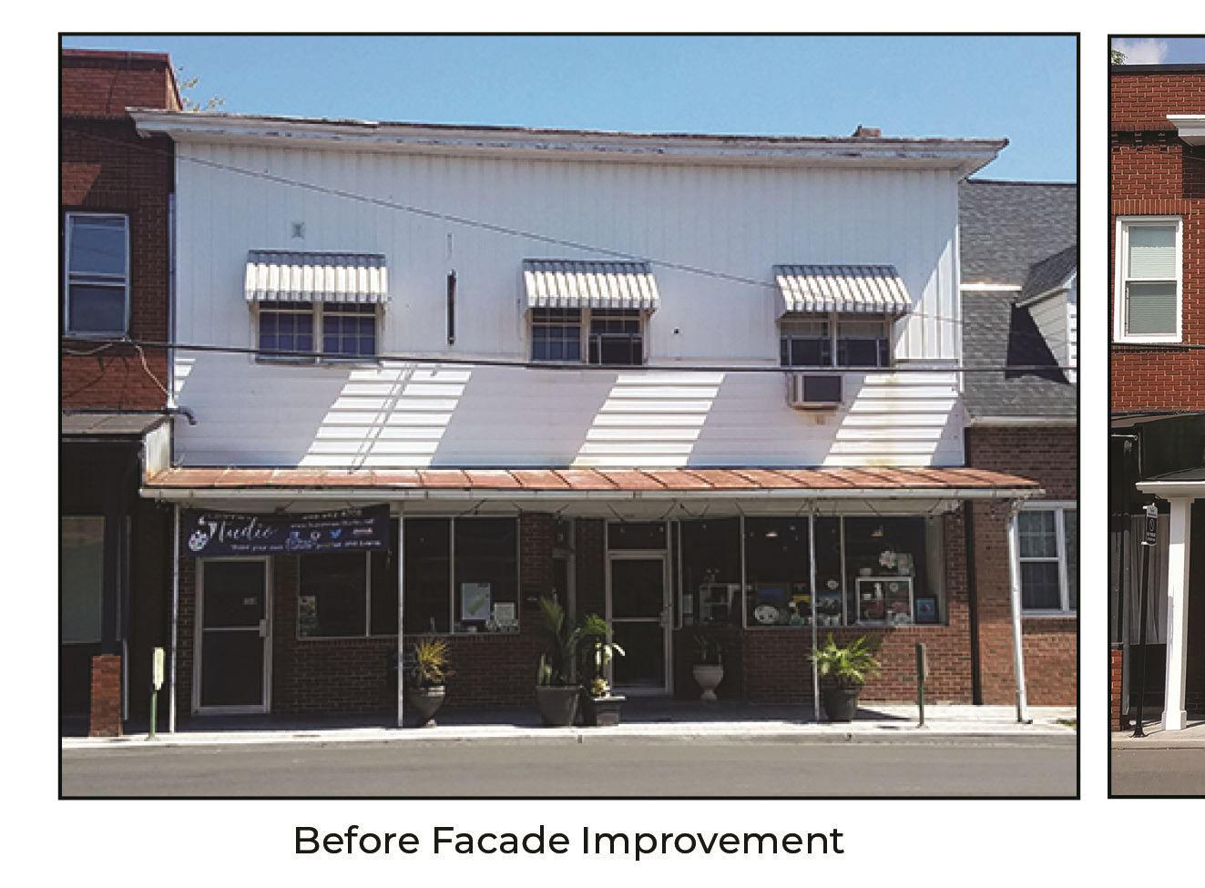
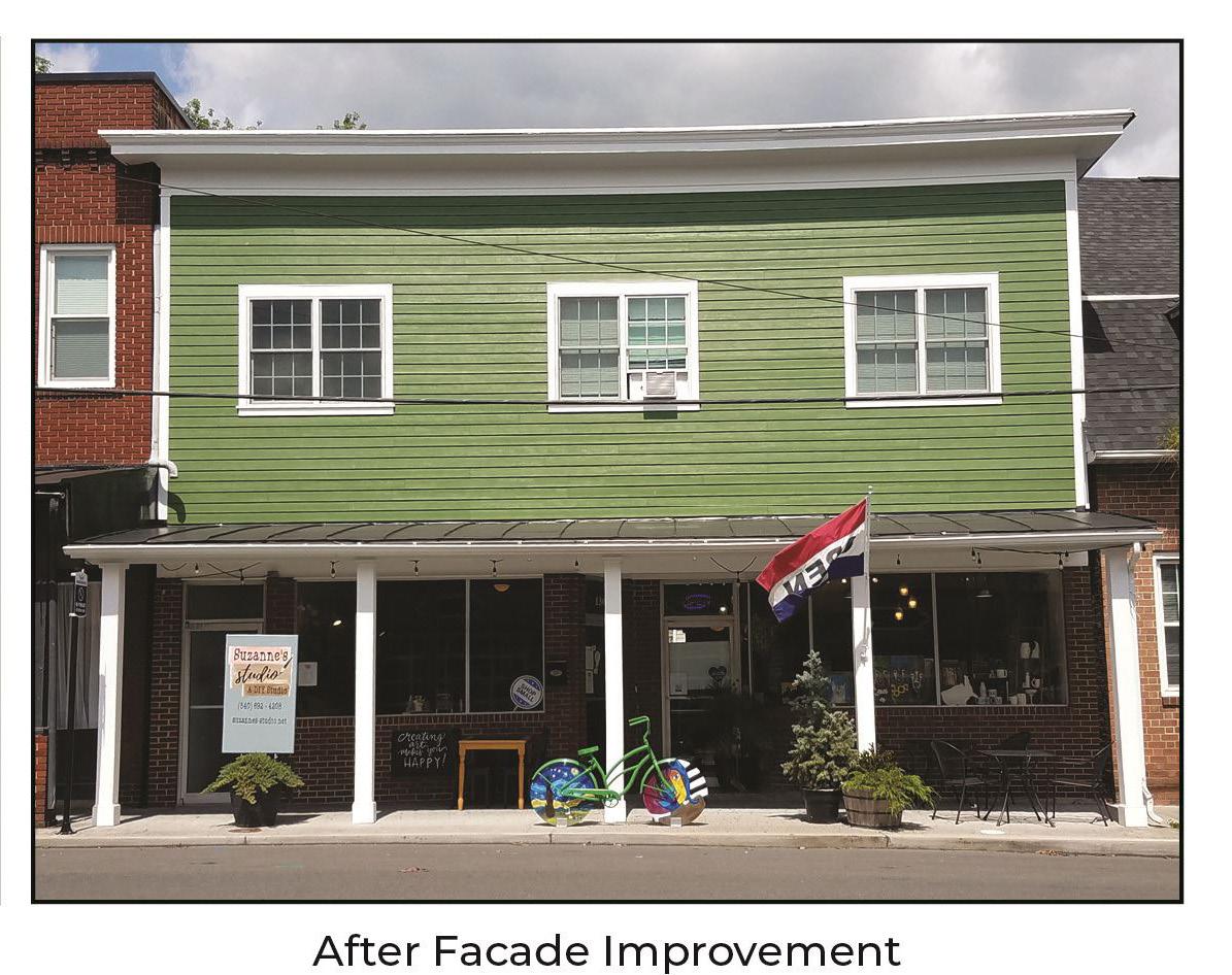
Grants for facade improvement are offered through the Town’s Economic Development Authority’s RENEW Grant Program.
The funds help businesses and property owners to refresh the facade of the building and make the downtown area more attractive.
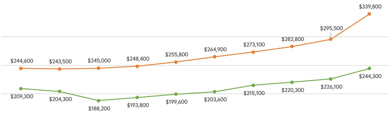
Median Household Income
The median household income in the Town of Woodstock is $61,210, with roughly 50% of households earning between $35,000 and $100,000 annually. Woodstock’s median household income is about $20,000 less than the statewide median of $80,963.
Median Household Income: $61,210
2021 American Community Survey, 5-Year Estimates, S1901
Median Household Income Comparison and Change Over Time
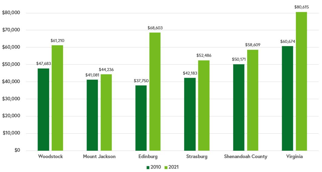
As shown in the bar graph below, median household income in Woodstock increased 28.4% between 2010 and 2021 (ACS estimates, not accounting for inflation). Other localities in the region and the County have also experienced a growth in median household income, most notably Edinburg at 81.7%. However, the median household incomes in the region are still less than the overall statewide median household income of $80,615.
Figure 19. Median Household Income
Figure 20. Median Household Income Comparison
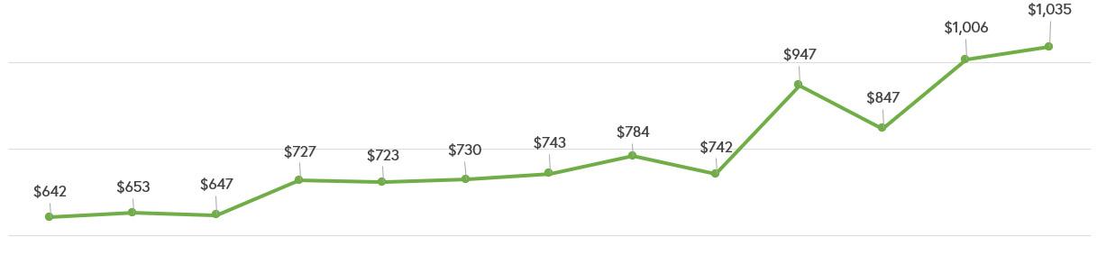
Individual Income
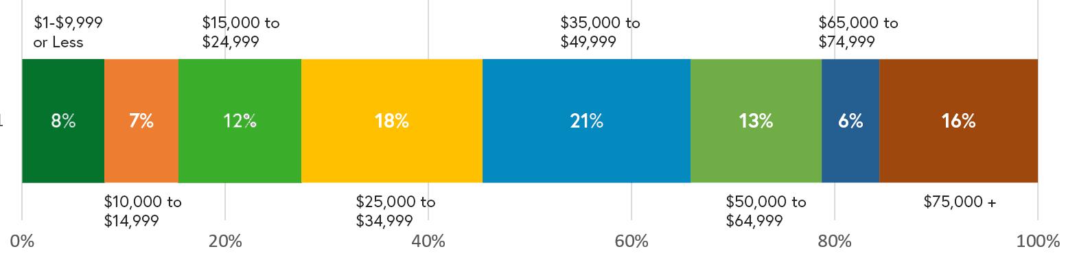
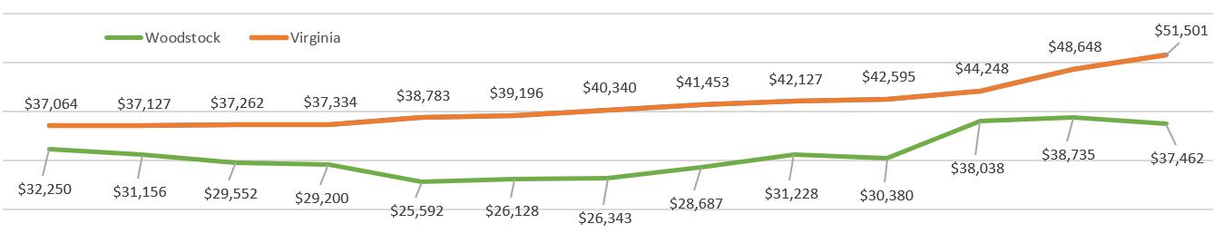
The breakdown of Woodstock residents individual incomes by percentage of population is displayed below, above a line chart depicting the median individual income in Woodstock over the previous decade. While incomes have generally increased in recent years, they are still below Virginia’s statewide median individual income.
Individual Income by Percentage of Population in 2021
2010-2022 American Community Survey, 5-Year Estimates, S1901
% Below Poverty Level
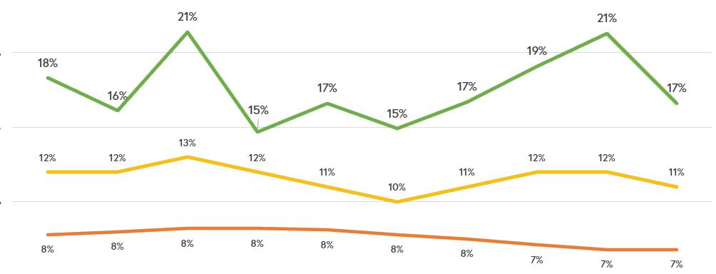
Poverty status is determined for individuals based on their annual income. The chart below shows Woodstock and Shenandoah County’s percentage of individuals under the poverty level over time compared to that of Virginia overall. Woodstock’s higher percentage over individuals under the poverty level may be attributed to older residents on fixed income as well as lower income individuals living in the most affordable housing around. United for ALICE is research branch of United Way, an international fundraising non-profit that targets social issues. ALICE stands for Asset Limited, Income Constrained, Employed, and as a definition seeks to inform public decisionmakers about populations outside of the traditional definition of poverty that are not yet financially stable. In the 2021 American Community Survey, the ALICE population for Shenandoah County was determined to be 29% of households and there were 11% of households in poverty.
2010 - 2021 American Community Surveys, 5-Year Estimates, S1701
Individual Income Over Time in the Town of Woodstock and the State of Virginia
Woodstock Shenandoah County
Virginia
Figure 21.
Figure 22.
Figure 23. % below Poverty Level
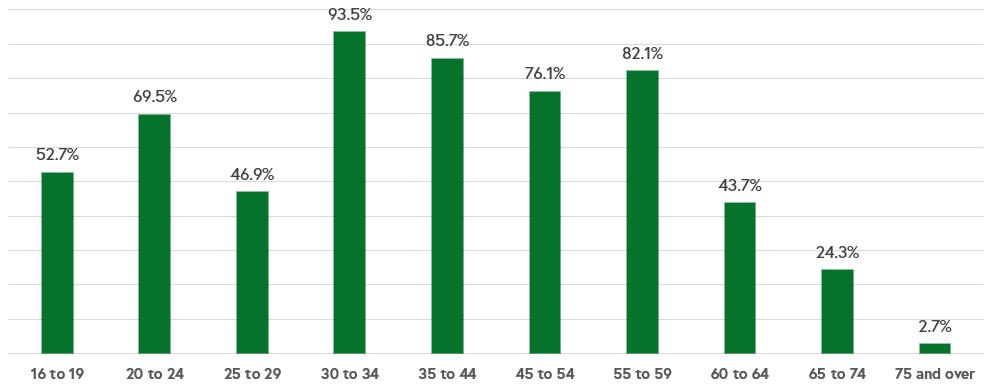
Labor Force Participation Rate
The Labor Force Participation Rate (LFPR) is the percentage of all people of working age who are either working or actively seeking work (Employed + Unemployed). Town of Woodstock’s LFPR is 59.6%, which is similar to the national rate of 61.8% and Virginia’s at 63%. The chart below shows the percentage of each age cohort’s percentage of the population participating in the labor force. The high LFPR for individuals between 30 and 60 years old shows that much of the Town’s population is employed, however, for younger individuals below 30 there may be a need to develop more pathways to employment.
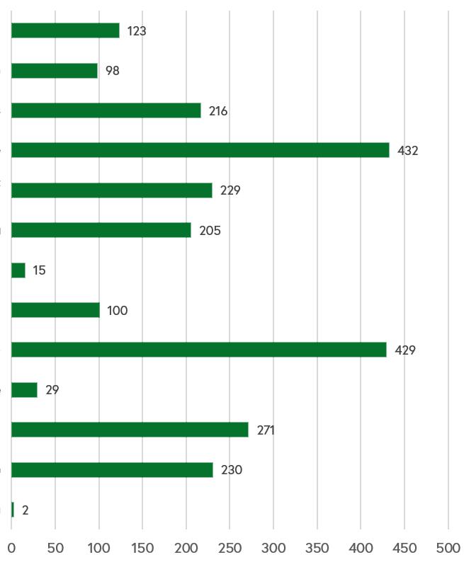
Employment by Industry
Most people in the Town are employed in “Educational services, and health care and social assistance,” this is typically the largest employer for most localities. Notably, many people in the Tow are employed in Retail trade. Employment data is difficult to track and is subject to seasonal shifts and under reporting. This may be the case for the low number of people employed in Agriculture, forestry, fishing and hunting, and mining.
2021 American Community Survey, 5-Year Estimates, S2301
Figure 24. LFPR Rate
2021 American Community Survey, 5-Year Estimates. S2405
Figure 25. Employment by Industry
Major Employers
The Top Ten Employers is adapted from the VA Employment Commission’s Shenandoah County Community Profile, dated 3/2/24. Note the list is for Top Ten Employers with a physical presence in Woodstock and that have a central office/headquarters in Woodstock. These employees do not necessarily live within the Town, for information on where Woodstock’s employees commute to and from, see the Mobility section of this Plan.
Figure 26. Major Employers
Unemployment Rate
The unemployment rate in the town in 2021 was estimated at 3.9%. Since 2010, the unemployment rate appears to have slightly increased in Woodstock. Unlike other places, the Town’s unemployment rate increased before the COVID-19 pandemic and dropped during it. For comparison, the rate was higher than Virginia and the United States overall rates at the beginning of the decade, but has since dropped below Woodstock’s. While this trend may seem like a large fluctuation, the unemployment rate is only marginally different over time.
Figure 27. Unemployment Rate
Goal
1: Retain and
attract new businesses to meet the needs of the current and future community.
Objective 1.1 Develop an economic development strategy that identifies target businesses by type and long-term economic goals.
Action 1.1.1 Focus on local quality job creation to increase opportunities to live and work in the same community in the future.
Action 1.1.2 Seek grants from state agencies such as the Department of Housing and Community Development and Virginia Tourism Corporation to support local business retention and development.
Action 1.1.3 Research rural development grants offered to towns such as Woodstock through federal agencies such as the United States Department of Agriculture (USDA).
Objective 1.2 Create a strategy for business development and education.
Action 1.2.1 Support Woodstock’s work in advancing economic vitality through program evaluation, development, and promotion. Consider special emphasis in the downtown area for services, restaurants, tourism, recreation, and retirement-age/teenage demographic needs.
Action 1.2.2 Meet with existing businesses to determine their needs and the needs of future businesses.
Action 1.2.3 Identify entrepreneurs that are operating small businesses from their home, garage, or their property and determine what their needs would be to locate to a brick-and-mortar location.
Objective 1.3 Attract additional grocery options, with an emphasis on support for local agriculture, entrepreneurs, and quality of life by strategically supporting food-related production, commercial, and retail businesses.
Action 1.3.1 Research alternative grocery options and barriers hindering the establishment of grocery stores in Woodstock.
Action 1.3.2 Coordinate efforts between local government and farmer’s markets to ensure the market is successful and accessible, such as advertising campaigns.
Goal 2: Encourage physical improvement or construction of new spaces for businesses.
Objective 2.1 Encourage the development of additional leasable spaces for restaurants and retail, especially in the downtown core.
Action 2.1.1 Utilize incentives and regulations to encourage owners to bring substandard commercial rental space up to standard through rehabilitation or rebuilding.
Action 2.1.2 Encourage more small footprint leasable spaces for new businesses at rents compatible with the scale of their business.
Objective 2.2 Establish a program to retain and improve existing business locations through the creation of incentives to reinvest.
Action 2.2.1 Consider opportunities with local banks or WEDA for setting up a low-interest or nointerest loan pool for building improvements in addition to the facade improvement grant program.
Goal 3: Coordinate efforts to maximize efficient and effective economic development.
Objective 3.1 Review relevant ordinances, regulations, and policies for consistency and support of economic development.
Action 3.1.1 Research best economic development policy practices established by other localities.
Action 3.1.2 Integrate all department perspectives and develop consistent messaging throughout the organization.
Action 3.1.3 Review the Zoning Ordinance for barriers to establishing new businesses where appropriate.
Objective 3.2 Collaborate with surrounding towns, Shenandoah County, and other economic development organizations on strategies for layering business attraction, retention, and expansion.
Action 3.2.1 Research best practices established by other localities in developing successful business retention and expansion strategies.
Objective 3.3 Consider what has drawn tourists to Woodstock and build on current successes.
Action 3.3.1 As local tourism grows, consider how to capitalize on tourism while maintaining local housing stock and supporting residents.
Action 3.3.2 Work with Shenandoah County and other tourism partners to identify new target tourist groups and find ways to connect them with experiences in Woodstock.
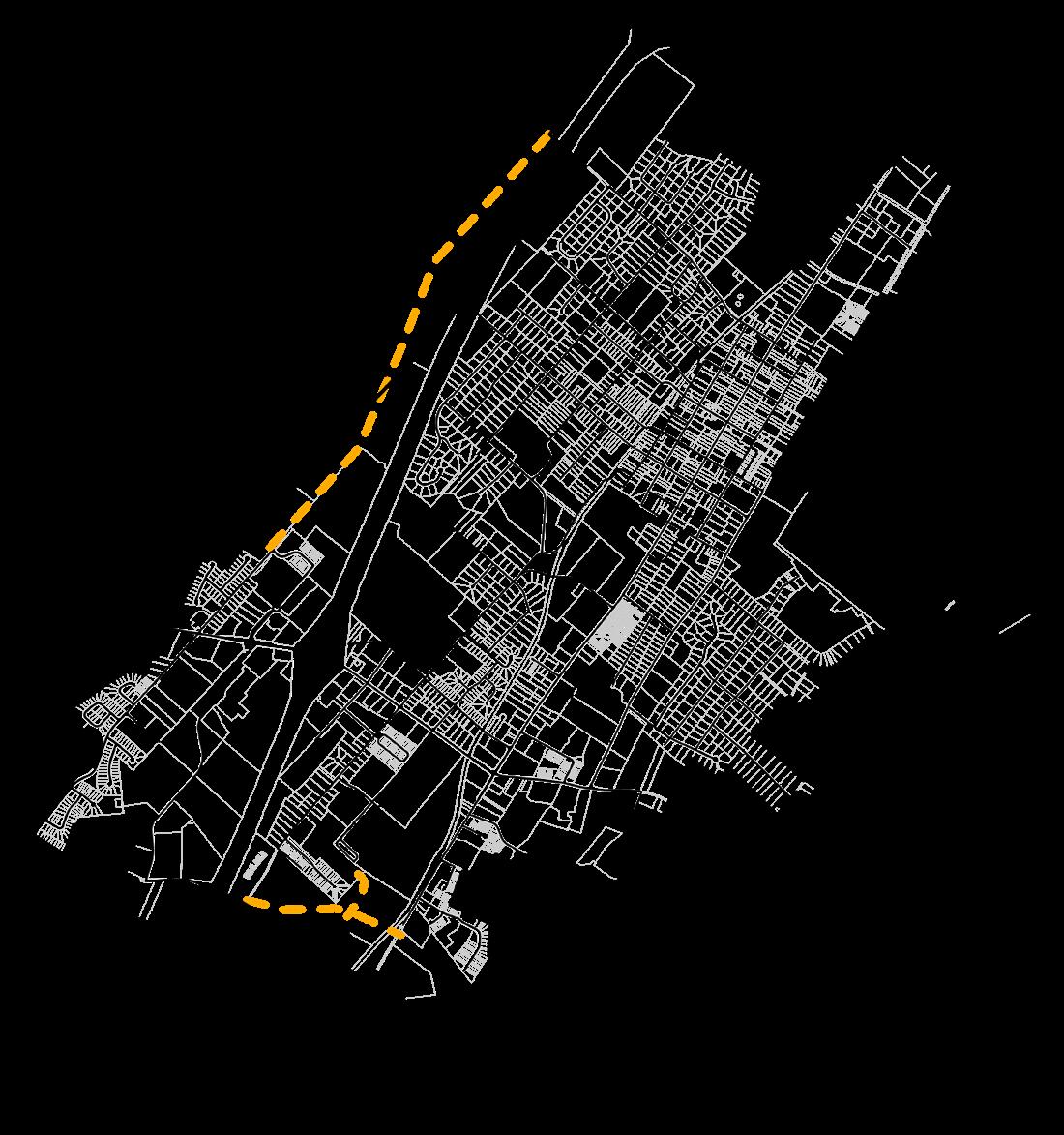
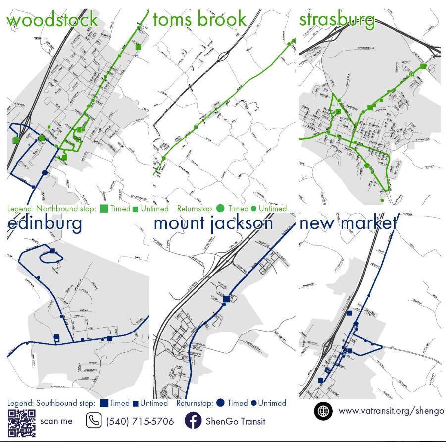
Mobility
Woodstock residents and visitors of all ages and abilities will be able to move around the Town safely, comfortably, and conveniently using their mode of choice. Bicycles, pedestrians, and other modes besides automobiles will be given increased importance for community benefits to health, safety, infrastructure, and the local economy.
Overview
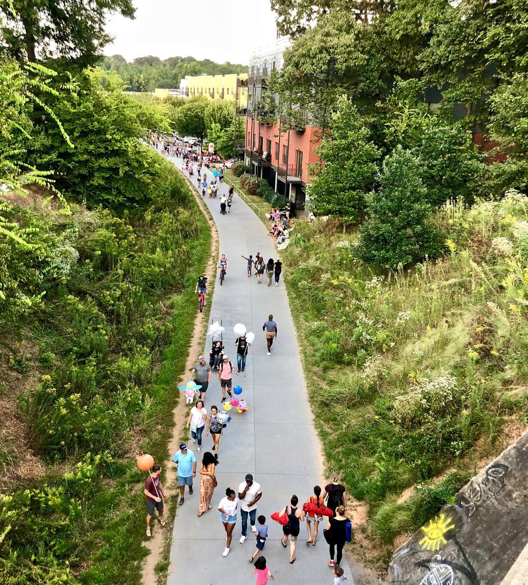
Woodstock’s downtown core represents how the Town’s residents historically moved around, a dense interconnected network of sidewalks and crosswalks for residents to walk to and from their destinations. As the Town grew over time and technology changed, the infrastructure shifted towards prioritizing motor vehicles, higher speeds, and requiring parking, which is reflective of the types of development and lack of pedestrian infrastructure in newer areas of the Town. Woodstock will be a place where residents and visitors will have transportation options to choose from, where one can walk, take a bus, or ride a bike as safely and as easily as driving a car to a destination. This freedom of mobility will transcend simply improving transportation in the Town, and will generate more opportunities for economic growth, improvements in health outcomes, and provide safe routes to school and other amenities for all age groups.
The Town will continue to thrive as a regional destination, particularly with new regional transportation infrastructure, such as the Rail to Trail. Embracing and enabling this opportunity should come with ensuring that visitors and users of the trail can access and appreciate more of Woodstock safely through multimodal improvements throughout the Town. These improvements in safety and comfort for bicycles and pedestrians, coupled with the pursuit of improved bus service through ShenGO will further, allow for trips to be made without an automobile. If one chooses to drive, it will also help relieve local congestion on roads. By reducing “vehicle miles traveled,” the Town can both accommodate new businesses and housing without compromising its “small town charm” or sense of place. The following pages present data that shows how Woodstock residents currently get around and commute.
This chapter fulfills the requirements of Section 15.2-2223 (B) of the Code of Virginia by presenting a transportation plan that identifies infrastructure needs and recommendations, as well as provides alignment of infrastructure with affordable housing, community services, and integration for elderly and disabled persons. Road and transportation improvements are identified and consistent with the Virginia Department of Transportation (VDOT) and Commonwealth Transportation Board (CTB) plans for future infrastructure upgrades. Transportation elements of the Plan are reviewed by VDOT to ensure consistency. The Plan is intended to be fully integrated with Woodstock’s adopted Bicycle & Pedestrian Trail Master Plan, which outlines specific pedestrian and bicycle infrastructure segments that connect the entire Town.
Review the Town’s Bicycle & Pedestrian Master Plan on the Town website for more specifics on infrastructure plans!
Commuting
90% of Woodstock residents get to work by commuting in a car, truck, or van. This is typical of other localities. 10% reported carpooling to work, while 0% reported Public Transportation use. This is potentially an inaccurate estimate, as services such as ShenGO provides regional transportation. However, limited service may not line up with shift schedules. Although Woodstock is a small locality, if there is further growth and development it may burden the local road system with greater traffic. If development is targeted around more dense areas of the Town, there is the opportunity to allow for a greater share of the community walking and bicycling to daily needs, employment, or even a expanded public transportation service.
Travel Time to Work
The largest percentage of Woodstock’s workforce is commuting 10 minutes or less to work (24.1%). 56.7% of Woodstock’s commuters travel less than 25 minutes to work. Shorter commutes to nearby places of employment can greatly improve quality of life through happiness and wellbeing.
However, 12.7% of commuters travel more than 60 minutes to work. Long commute also come at a higher cost in vehicle maintenance and fuel.
2021 American Community Survey, 5-Year Estimates, S0801
2021 American Community Survey, 5-Year Estimates, S0801
Drove alone (90%)
Carpooled (10%)
Figure 28. Mode of Commute
Figure 29. Travel Time to Work
Worked outside of state of residence (3.2%)
Place of Work
When commuting times are crossreferenced with the place of work, it is noticeable that 65.5% of the population works in their County of residence. As mentioned previously about “bedroom communities” or the impacts of longer commutes on quality of life, it is important to examine transportation patterns and ensure that places of employment, recreation, residency, and commercial uses are all available locally. Fortunately, for Woodstock, most of local residents work within the Shenandoah County area.
Commuting To/From
in county of residence (65.5%) Worked outside of county of residence (31.4%)
American Community Survey, 5-Year Estimates, S0801
The tables below are produced by the U.S. Census Bureau’s “OnTheMap” application, which gives insight into where employed workers are commuting to (from Woodstock), and commuting from (to Woodstock). There are a total of 4,329 people employed within Woodstock, with 3,866 people commuting to Woodstock. Employment is generally spread throughout the region with a much larger inflow of workers than outflow. Employment in Northern Virginia areas such as Chantilly, Arlington, and Fair Oaks, is notable as telework and highway connectivity allow for an approximately 1 hour commute to large areas of employment.
U.S. Census Bureau, OnTheMap Application and LEHD Origin-Destination Employment Statistics, 2021.
2021
Live in Woodstock, Employed Outside of Town 1,875 workers
Figure 30. Place of Work
Figure 31. Commuting Patterns
Employed in Woodstock, Live Outside of Town 3,866 workers
Bicycle & Pedestrian Master Plan (2019)
The Town adopted the Bicycle & Pedestrian Master Plan in June 2019. The Plan explored Woodstock’s existing conditions and conducted public outreach to identify where the Town’s community wanted to go and how the community wanted to get there. The vision states, “The Woodstock loop provides 12.45 miles of active transportation infrastructure, connecting Woodstock residents and visitors to nature, neighborhood parks, schools, and the Historic Downtown, without having to use a car.” The Plan details 74 potential project and infrastructure/facility type recommendations across the Town that will make the Town safer and more convenient for bicycles to get around. The Comprehensive Plan is linked to the Bicycle & Pedestrian Master Plan as the main guiding plan for tracking and implementing progress towards overall goals and vision. Some projects are already underway, such as a connecting bicycle path between Fairview Park on West North Street and West Spring Street (considered Phase I). Other projects include a new sidepath on West Spring Street, South Summit Avenue, and a sidewalk along West Court Street. Throughout the Downtown along Court Street, new ADA ramps, and bumpouts, are all in the process of being engineered and constructed (considered Phase II). More information can be found on the Town’s website regarding the status of implementation.
The map, from the Bicycle & Pedestrian Master Plan, below depicts the locations of the existing and proposed infrastructure improvements throughout the Town.
Figure 32. Bicycle & Pedestrian Master Plan Map
Rendering of Bicycle & Pedestrian improvements along E. Court St.
Recommendations
While there are ongoing projects that are Town-initiated and funded, certain projects may also be listed in the Comprehensive Plan as recommendations. These projects may make their way into VDOT’s various programs and find funding for planning, engineering, design, and construction, however, they are not exhaustive of all of the mobility-related projects that Woodstock plans for. These preliminary descriptions and cost estimates are related to ongoing work the Town has conducted regarding two important future connecting roads that allow for circular transportation flow around the entirety of Woodstock.
1. Part of Hisey Avenue Extension - The Hisey Ave. extension is planned to reach W. Spring St. Construction of the extension is to be partially completed by adjacent subdivision development, however, the remaining 0.6 mile road with sidewalks to W. Spring St. remains as a potential project. Estimated cost:
2. Realignment of Hoover Road - The relocation of Hoover Road to connect to the Shenandoah County Public Schools Campus was studied in 2013 by McCormick Taylor in consultation with VDOT. This project includes approximately 1 mile of roadway and sidewalk, realigning Hoover Ave.’s connection with Main Street and adding a connecting road to the school campus. Estimated Cost: 1. 2.
Functional Classification
The Federal Highway Administration (FWA) classifies roads based on mobility (how fast vehicles can move from one point to another) and access (the number of opportunities for vehicles to enter or leave that road). These designations influence decisions regarding maintenance and infrastructure projects. The Town of Woodstock’s Public Works Department owns and maintains its own roads with the exception of arterial and collector roads, such as Route 11, Interstate 81, and Route 42.
Roads are designated with one of the following classifications:
High Mobility (High Speed)
• Interstates
• Other Expressways
• Principal Arterials
• Minor Arterials
• Major Collector
• Minor Collector
• Local Roads
High Access (Lots of Places to Enter/Exit)
Figure 33. Functional Classification of State Roads Map
Public Transportation
Bus transit service is provided through the ShenGO! system, with routes throughout Shenandoah County. Funding was initially provided by the Virginia Department of Rail and Public Transportation through a grant that was obtained by the local Planning District Commission, the Northern Shenandoah Valley Regional Commission (NSVRC), and is now subsidized by the area’s localities. Each trip costs only $1.00. Annual ridership data has showed a continuous increase, highlighting the growing demand for varied transportation options in the region that can further connect Woodstock to its neighbors without the use of a car.
ShenGO! Annual Ridership Counts
Photo from the Northern Virginia Daily of a ShenGO bus.
The maps above depict the available routes for ShenGO service. Please visit the ShenGO website for the bus schedule as well as other information regarding the public transportation service.
Annual Average Daily Traffic
Annual average daily traffic (AADT) is a measure of how many vehicles travel a section of a road each day, expressed as an average value from traffic counts taken over the course of a year. The Virginia Department of Transportation (VDOT) will generally prioritize maintenance or upgrade projects for roads with higher AADT.
Route 11 (Main Street) and Route 42 (West Reservoir Road) are the Town’s most heavily traveled roads, excluding Interstate 81.
Route 11 / Main Street through Woodstock.
West Reservoir Road, looking north.
Figure 34. Traffic Volume on State Roads
Crashes
The following map shows the amount of recorded crashes along Woodstock’s roads. Notably, all areas of Woodstock experience crashes. Typically, crashes are recorded along the highest traveled corridors, but there are some notable patterns. Intersections, in particular, have crashes recorded even in neighborhoods. Woodstock’s most traveled roads are where the highest amount of crashes occur, with strong clusters occurring along Main Street through the historic downtown area and along West and East Reservoir Road. Crash severity data for categories “A - Serious Injury” and “K - Fatality” have been included showing where particularly destructive accidents have occurred. The Comprehensive Plan will seek to proactively plan to eliminate crashes of all types, saving life and property from harm.
occur.
From Vision Zero Network
S. Main Street and E. Reservoir Road, where many crashes
Crashes Recorded at Location
Few Many
Crash Severity
Data Source: Virginia Department of Transportation
Figure 35. Crash Data Map
Rural Long Range Transportation Plan
VDOT worked with the Northern Shenandoah Valley Regional Commission, which serves as the Planning District Commission (PDC) for the region, to develop the 2035 Rural Long Range Transportation Plan (RLRTP). This plan was released in 2011, and covers the geographic areas of Shenandoah, Frederick, Clarke, Warren, and Page Counties as well as their incorporated towns, such as Woodstock. As is the case with a Comprehensive Plan, the RLRTP is visionary in nature and provides recommendations that are not financially constrained.
The map below highlights the transportation system deficiencies in Town of Woodstock identified in the RLRTP. These deficiencies and recommendations are outlined in the table on the following pages.
*A potential project listed on the RLRTP is not guaranteed to be completed by VDOT. Through the comprehensive planning process, the Town will identify priority transportation projects using the RLRTP as a guide.
The RLRTP can be accessed at: http://nsvregion.org/documents.html
Transportation Deficiencies Intersection
Operation Improvement
Safety Improvement Segment
Operation Improvement
Safety Improvement
Operation & Safety Improvement
Data Source: Regional Long Range Transportation Plan
Figure 36. Deficiencies Map
1 I-81/VA 42 Intersection Operation Short-term apply access management and sign westbound left turn lanes to indicate access to Wal-Mart versus Lowes; Mid-term construct parallel access roads from Minor Road; Long-term reconstruct interchange (project in environmental stage).
2 VA 42 / Ox Rd.
3 VA 42/US 11
Operation Add northbound left turn lane. Continue to monitor for potential improvements after northbound left turn lane is added.
with low priority. Continue to monitor for potential improvements.
Long-term reconstruct road to rural six-lane standards (project in environmental stage).
5 US 11 (Main St.) Lakeview Dr. W. Reservoir Dr. Operation Long-term upgrade to urban four-lane roadway.
6 US 11 (Main St.) Indian Spring Rd. W. N. St. Operation Long-term upgrade to urban four-lane roadway.
VA 42 / Hisey Ave.
Long-term reconstruct road to address geometric deficiencies (11-foot lanes).
Long-term perform signal study and install signal when warranted.
Long-term add a westbound right turn lane, a northbound right turn lane, and a southbound left turn lane.
Long-term construct new interchange on I-81 providing access to VA 676, VA 604, VA 642, and US 1 (further study required to define specific improvements).
construct southbound left turn lane and northbound right turn lane.
16 US 11/Lora Drive (1,500 ft. of Hoover Rd.)
Intersection Operation Mid-term construct southbound left turn lane and northbound right turn lane.
17 VA 42 Reservoir Rd. Western Woodstock Boundary I-81 W Safety
18 VA 42 Reservoir Rd. I-81 W Susan Ave. Safety
Long-term improve and widen VA 42 from current configuration to four-lane urban divided standards and implement access management.
Long-term improve and widen VA 42 from current configuration to four-lane urban divided standards and implement access management.
19 Hisey Ave. Extension N. Hisey Ave. N. St. Operation Long-term extend Hisey Ave. from current northern terminus to N. St. and construct extension to rural two-lane standards.
20 Hisey Ave. Extension (Central) Hisey Ave. Spring St. Operation
21 Hoover Rd. Hisey Ave. Ext. Water St. Ext. Safety
Long-term reconstruct road to address geometric deficiencies (11-foot lanes).
Long-term reconstruct roadway to two-lane rural standards.
22 Hisey Ave. S. Hisey Ave. Hoover Rd. Operation Long-term extend Hisey Ave. from current terminus to N. St. and construct extension to rural two-lane standards.
23 Ox Rd. Hoover Rd. Park Ave. Safety
24 Massanutten Heights Ox Rd. Commerce St. Safety
Long-term reconstruct roadway to two-lane rural standards.
Long-term reconstruct roadway to two-lane rural standards.
25 New Connector Rdwy. VA 676 Main St./ Moose Rd. Intersection Operation Long-term construct roadway on new alignment to two-lane rural standards.
26 Proposed Central High School Access Rd. School Complex Hoover Rd. Operation Long-term provide additional access to the school for improved circulation.
Figure 37. RLRTP Table
Six-Year Improvement Program
Transportation improvement projects that are recommended for funding by VDOT feature in the Six-Year Improvement Program (SYIP), which can be viewed at http://syip.virginiadot.org/Pages/ allProjects.aspx. These projects may have been featured in the Town’s RLRTP.
There are seven road improvement projects in Woodstock that are included in the FY2024 - FY2029 SYIP, four of which are Bicycle and Pedestrian facilities or safety improvements. However, these projects are not scheduled to have construction completed for the next few years.
Improvements along Route 42 stem from the Route 42 Corridor Improvement Study, published in January 2020 by the VDOT Staunton District Office. The study utilized the adopted Bicycle & Pedestrian Master Plan from 2019 to identify potential multi-modal facilities that would address issues along the heavily traveled route.
Virginia Department of Transportation
Figure 38. VDOT SYIP Table
Scheduled Fiscal Year of Construction
Data Source: Virginia Department of Transportation
Figure 39. VDOT Projects Map
Goal 1: Expand public transportation in Woodstock.
Objective 1.1 Coordinate with ShenGO to improve routes in Woodstock.
Action 1.1.1 Increase the frequency of bus headways and number of stops by working with partner agencies and localities.
Action 1.1.2 Establish permanent bus shelters with seating and other amenities throughout Woodstock.
Goal 2: Enhance pedestrian safety and comfort throughout the Town.
Objective 2.1 Utilize traffic calming devices throughout the community to ensure safety.
Action 2.1.1 Continue the use of the “tactical urbanism” program to calm traffic on neighborhood streets and other areas throughout the community.
Action 2.1.2 Provide traffic calming measures, such as curb extensions/”bump outs,” neighborhood roundabout islands, and other measures throughout the Town.
Objective 2.2 Ensure that mobility-impaired community members are protected and able to access all sidewalk facilities throughout the community.
Action 2.2.1 Ensure that sidewalks and trails are wide enough to accommodate strollers, wheel chairs, or other mobility devices and are free of obstructions such as signage and utility poles.
Action 2.2.2 Ensure that all new sidewalks and sidewalk repairs meet ADA accessibility standards.
Objective 2.3 Strengthen streetscape connections by installing pedestrian infrastructure such as sidewalks, crosswalks, pathways, and trails where such infrastructure is missing.
Action 2.3.1 Develop Town-wide public realm standards to include shade trees, bike parking, bike share, signage, public art, screened parking, street furniture, pedestrian-level lighting, and other elements in the public right-of-way that enhance walkability.
Action 2.3.2 Conduct and maintain a sidewalk inventory.
Action 2.3.3 Expand the annual allocation of funds for sidewalk and multi-use trail improvements in the capital improvements program.
Action 2.3.4 Require developers to construct sidewalks and street trees as part of their development projects, including up-coming infill developments in neighborhoods.
Action 2.3.5 Implement continuous sidewalks throughout key pedestrian areas in the Town. Sidewalks should continue the same grade with cars having to pass “over the sidewalk” rather than a curb cut stepping down for the pedestrian.
Action 2.3.6 Implement deferred maintenance budgets in capital improvement budgets to make repairs to pedestrian infrastructure when damage occurs.
Objective 2.4 Increase the amount of street furniture throughout the Town, including benches, trash cans, bicycle repair stations, bicycle parking, and other amenities to allow for resting while traveling between destinations.
Goal 3: Ensure that there are Safe Routes to Schools, particularly by walking and biking.
Objective 3.1 Coordinate with VDOT to establish safe crossing points that allow for pedestrians or bicyclists to directly and conveniently reach the school.
Action 3.1.1 Consider adding signalized pedestrian crossings to key intersections for pedestrians, especially near the schools.
Objective 3.2. Address school drop-off congestion
Action 3.2.1 Conduct a traffic study at schools during peak hours.
Action 3.2.2 Create walk and/or bike “bus” programs that offer students the ability to walk or bike as a group safely to school chaperoned by volunteers to ensure their safety.
Objective 3.3 Seek state and federal grants for Safe Routes to Schools.
Goal 4: Improve safety, traffic congestion, and flow.
Objective 4.1 Work with Virginia Department Of Transportation (VDOT) to improve safety at key intersections.
Action 4.1.1 Coordinate efforts with VDOT to identify roadway safety improvements, especially on Reservoir Road.
Action 4.1.2 Incorporate safety considerations into the design of roadways for all travel modes.
Action 4.1.3 Identify pedestrian safety improvements to Route 11 through downtown.
Objective 4.2 Consider how to deal with and expedite high traffic events, such as I-81 closures.
Action 4.2.1 Consider designating alternate routes to Henry Ford Drive from the north side of the Town.
Action 4.2.2 Continue to explore the north connector extension of Hisey Avenue north to West Spring Street or West North Street/Fairview Road. Additional considerations may reference the limited frequency but high traffic impact of events at the fairgrounds.
Objective 4.3 Assess and seek to mitigate the transportation impacts of development and redevelopment projects.
Action 4.3.1 Require traffic impact studies with all rezoning and special-use permit applications proposing development that will create a significant traffic impact. Such studies should meet the requirements of the Virginia Department of Transportation for traffic impact analyses and should encourage transit, pedestrian, and bicycle use.
Objective 4.4 Create, adopt, implement, and update regularly a Town Road Improvement Plan of needed road and intersection improvements. This plan will serve existing and future land uses and should be coordinated with road improvement plans of the Virginia Department of Transportation and Shenandoah County.
Action 4.4.1 Annually review, update, and expand the town’s Road Improvement Plan to include additional projects as deemed necessary.
Action 4.4.2 Expand the plan to include multi-use trail projects identified in the Bicycle and Pedestrian Master Plan.
Objective 4.5 Identify potential sites for a future structured public parking facility in the downtown area.
Objective 4.6 Consider strategic street extensions and/or realignments to facilitate future mobility, such as Hisey Avenue to Spring or North Street; Eagle Street to Reservoir Road; and a second school access street from Falcon to Hoover or Route 11.
Goal 5: Improve multimodal safety and comfort throughout the Town.
Objective 5.1 Safe, protected bicycle infrastructure will be implemented along roads throughout the community.
Action 5.1.1 Fully implement the Bicycle and Pedestrian Master Plan. Update and expand as needed.
Action 5.1.2 Monitor success of the plan by counting bicycle users and pedestrians in key areas as resources become available.
Action 5.1.3 Ensure that the bicycle system can be utilized by all members of the community by utilizing best practices, such as protected or separated bicycle lanes.
Action 5.1.4 Inventory and map the locations of bicycle parking to ensure that there is availability across Town.
Objective 5.2 Increase the number of bike racks on sidewalks and/or use the curb to provide on-street bike parking.
Action 5.2.1 Select simple standardized forms of bicycle racks that can be used throughout the Town. Work with property owners around the Town to ensure bicycle parking spaces are located in convenient places near the entrance.
Action 5.2.2 If needed, replace select automobile parking spaces for “bicycle corrals” where multiple racks can be located within the space of one private automobile space.
Objective 5.3 Explore events such as a “Ciclovia” to close parts of the downtown area (such as a dedicate time on Saturday mornings or one day a month) to car traffic to allow for recreative use of other modes of transportation that help to build community.
Action 5.3.1 Consider permanent or temporary street closures and expanding and improving bike-walk streets, which are not entirely closed to cars but use physical infrastructure to slow cars. This could include, but is not limited to, weekend closures of parts of the downtown for bicycle, pedestrian, and retail use.
Objective 5.4 Create an “ad campaign” style communications program about the benefits of walking and bicycling for the community’s health, safety, local economy, and infrastructure.
Action 5.4.1 “Ad campaigns” used elsewhere have created posters or other materials that say “Hello! Thank you for bicycling. You are contributing by ____” When people begin to see other people bicycling, they will consider the option for themselves.
Goal 6: Prepare the Town for the Rail Trail.
Objective 6.1 Ensure that all necessary connections, amenities, signage to and from, and collaboration with local businesses is coordinated to capitalize on the trails development.
Action 6.1.1 Proactively address potential parking issues for the trail. Ensure that existing parking is well signed and marked. Allow for paid lots to accommodate increased visitation due to Rail Trail.
Action 6.1.2 Consider the creation of a specialty overlay district that provides greater development flexibility along the trail corridor.
Public Services, Utilities, & Infrastructure
The Town will continue to provide excellent services and build resiliency into its utility and infrastructure systems.
Overview
One of the great reasons to live in Woodstock is the quality of local services and infrastructure, as well as the dedication of the staff that work to maintain them. The public engagement process included a focus group of Town employees, and it was discovered that the overwhelming majority of participants were born and raised in Woodstock or nearby and were still working to make the Town the wonderful place it is today.
The Town provides public utilities services including water supply and sewage treatment, police protection, parks and recreational facilities. Shenandoah County provides the local public school system, libraries, solid waste disposal, courts, social services, and other parks and recreational facilities. Both entities collaborate for volunteer fire and rescue services.
Maintaining utility infrastructure and services is an ongoing challenge for any community. Replacing aging systems and investing in future upgrades must always be balanced with the Town’s revenue, available grants, and future plans. The Comprehensive Plan seeks to address these challenges by keeping the Town constantly engaged with opportunities to improve water quality and address stormwater run-off into the Shenandoah, as well as prevent damage from flood events. Most importantly, securing a secondary water source aside from the Shenandoah River is identified as a critical need for the Town and the surrounding area.
Woodstock’s Police Department can be found at 134 N Muhlenberg St.
The Town decorates its utility boxes by wrapping them with public art.
Woodstock’s wastewater is treated at its plant along the banks of the Shenandoah.
Community Facilities & Cultural Venues
Community facilities in Woodstock include government buildings, schools, emergency resources, and recreation facilities. These facilities are funded wholly or in-part by tax dollars, and they are accessible to the community at-large or otherwise provide essential services for life in Woodstock. On the map to the right, there are also some important “Entertainment” venues identified, such as the Shenandoah Downs, where the County fair takes place, the Woodstock Museum, Community Theatre, and the Museum of Contemporary Art. These are some of the places that Woodstock builds its community and quality of life, hence their inclusion alongside typical public community facilities. Medical centers, such as the local Shenandoah Memorial Hospital, are also important assets for the community, improving the health and quality of life of the Town.
As shown on the following map, there is a cluster of schools and government administration buildings in the southwest area. There is also a concentration of facilities in the walkable area of downtown, including the library, community theatre, town hall, post office, museums, and courts. Shenandoah County’s government facilities are mostly located in the northeast section of Town.
Venues
Figure 40. Community Facilities Map
Goal 1: Enhance Town services by creating a resilient built environment.
Objective 1.1 Support Shenandoah County Public Schools in the delivery of quality education through well-designed learning environments.
Action 1.1.1 Collaborate with Shenandoah County to support education goals through infrastructure, connectivity, public spaces and parks, and specialty programming, such as including students in the maintenance of the school arboretum.
Objective 1.2 Maintain public safety through resilience planning.
Action 1.2.1 In cooperation with federal, state, other local law enforcement and emergency preparedness agencies, and Shenandoah Memorial Hospital, provide for continual maintenance and updates in collaboration with the Shenandoah County Emergency Operations Plan and the Regional Hazard Mitigation Plan.
Action 1.2.2 Encourage new development that takes public safety into consideration and use code enforcement measures to ensure that properties continue to be maintained.
Action 1.2.3 Foster safe environments and communities through active and well-designed places that have high visibility and lots of activity, discouraging negative social behavior.
Objective 1.3 Ensure that all local government facilities are well maintained and functionally appropriate to meet all requirements. Proactively invest in necessary municipal, police, and public works space needs to meet the demands of a growing community.
Goal 2: Provide high quality Water, Sewer, and Stormwater services
Objective 2.1 Continue to provide high quality public water service.
Action 2.1.1 Maintain the existing water system components through programs that emphasize repair, protection, system reliability, water quality, and water loss reduction. Develop a comprehensive maintenance and replacement schedule for our infrastructure.
Action 2.1.2 Continue to add water supply, treatment, distribution, and storage capacity as growth requires.
Action 2.1.3 Develop a Water Works Facilities Plan for the water system to provide a comprehensive assessment of the town’s infrastructure and its ability to store and deliver the amount of water anticipated at full build-out predictably and sustainably.
Action 2.1.4 Identify a potable water source through groundwater to supplement the river intake.
Action 2.1.5 Develop a plan to address compliance with new state and federal standards on removing PFOS (perfluorooctane sulfonate) pollutants as well as mitigating the potential impacts of Harmful Algae Blooms (HAB) on the potable water supply.
Objective 2.2 Continue to provide dependable, environmentally sound, sanitary sewer service.
Action 2.2.1 Continue the Town’s wastewater system repair and maintenance programs that emphasize repair, preventive action, and reliability. Develop a comprehensive maintenance and replacement schedule for our infrastructure.
Action 2.2.2 Continue the Town’s abatement program addressing infiltration and inflow to the wastewater collection system.
Action 2.2.3 Continue and enhance the Town’s grease trap inspection program to eliminate grease, oil, and sand from the wastewater system.
Action 2.2.4 Develop a Wastewater Facilities Plan for the wastewater system to provide a comprehensive assessment of the town’s infrastructure and its ability to collect and transport the amount of wastewater anticipated at full build-out.
Action 2.2.5 Identify future expansion need for sewer capacity and set a reserve fund for when expansion is needed.
Objective 2.3 Continue to improve the quality of stormwater runoff in and around the town.
Action 2.3.1 Develop and implement a public education and outreach program regarding the impacts of stormwater discharges on streams.
Action 2.3.2 Prepare a Drainage Master Plan to assess stormwater and identify areas for improvement to reduce flooding and overland sheet flow.
Action 2.3.2. Detect and eliminate illicit discharges to the sanitary sewer system.
Action 2.3.3 Continue to work with Shenandoah County to enforce the Erosion and Sediment Control ordinance.
Action 2.3.4 Maintain and improve programs to prevent pollution and practice good housekeeping in town operations.
Action 2.3.5 Use sustainable design principles and concepts for town facilities.
Goal 3: Ensure the Town’s resources are invested equitably and sustainably across the community
Objective 3.1 Annually revise, adopt, and maintain a Capital Improvement Plan (CIP)
Action 3.1.1 Balance the Five Year CIP as required by the Code of Virginia (§15.2-2239).
Action 3.1.2 Update the CIP annually as part of the annual budget process.
Action 3.1.3 Identify one-time funding sources such as grants, donations, and in-kind sources to develop capital amenities.
Action 3.1.4 Identify CIP items that equitably serve residents while limiting impacts to Town resources.
Objective 3.2 Ensure that revenues adequately support current and future service and infrastructure needs.
Action 3.2.1 Review previous capital improvement spending and determine what gaps may exist or what projects have not received funding in recent years.
Action 3.2.2 Put aside funding for each capital improvement budget towards deferred maintenance budgeting.
Trails, Parks, and Recreation
The Town will continue to invest in high quality parks and recreation facilities. Creative and diverse activities will be possible to ensure that all age groups are engaged and attracted to enjoy use of Woodstock’s spaces.
Overview
Woodstock currently enjoys some of the best parks in the region, along with access to state parks, such as Seven Bends, that are destinations for travelers from far and wide. Residents of the Town greatly appreciate the many park amenities there are to serve a wide range of ages and abilities. Additional improvements will be made to further the equitable accessibility of Woodstock’s parks to ensure that accessibility continues to improve and that parks can be accessed by all neighborhoods. Trails will serve transportation purposes as well as recreational purposes as a reliable way for residents and visitors to reach parks and other important destinations.
Through partnerships with local organizations and regional entities, Woodstock will improve its park accessibility, programming, and cultural events. The Town will enable more opportunities for community events through symbiotic relationships with organizations for shared facilities. Park facilities will also advance the expansion of the tree canopy, assist in sustainable stormwater management, and help transfer the stewardship ethic present in the community from generation to generation.
Woodstock will be a recreational destination for visitors from far and wide and residents will enjoy the diverse array of cultural events, parks, trails, and recreational opportunities year-round. Local organizations will be able to reach a larger audience through events in Town parks and support from the local government.
Jean Fogle Nature Sanctuary Boardwalk path in Woodstock’s W.O. Riley Park.
The selected Master Plan for the Town’s new Larry D. Bradford Fairview Park!
Goal 1: Woodstock will enhance public health and quality of life in the community through high quality parks, recreation facilities, and pedestrian and bicycle improvements.
Objective 1.1 Improve active connections throughout the Town and surrounding areas through trails and bicycle lanes.
Action 1.1.1. Pursue funding and timely implementation of trails, bike lanes, and sidewalks utilizing the Bicycle and Pedestrian Master Plan.
Action 1.1.2. Promote active recreational groups through Town communications and foster events that encourage usage of pedestrian and bicycle improvements.
Objective 1.2 Develop equitable active recreational improvements for all ages and abilities.
Action 1.2.1. Inventory park resources and infrastructure to determine accessibility for residents of all ages and abilities or disabilities.
Action 1.2.2. Foster welcoming environments in parks and recreation facilities for a diverse population through safety enhancements such as lighting and paved pathways.
Action 1.2.3. Consider the accessibility needs of multi-generational residents when improving trails, parks, sidewalks, and recreation facilities.
Action 1.2.4. Explore creating active recreational uses such as skate rinks, skate parks, climbing walls, chess boards, and other uses that encourage physical activity and play.
Action 1.2.5 Explore creating passive recreational access, such as therapy gardens, mazes, “forest bathing” trails, for sensory rest in a natural setting.
Objective 1.3 Foster symbiotic partnerships with organizations for shared facilities.
Action 1.3.1. Partner with various organizations to develop shared recreational facilities that benefit residents through enhanced programing.
Action 1.3.2. Build upon established relationships to seamlessly permit programmatic and cultural usage of Town recreational facilities.
Goal 2: The Town will continue to support and enhance cultural programs and activities.
Objective 2.1 Support local organizations in their efforts to provide cultural events and programs.
Action 2.1.1. Provide opportunities for local organizations to utilize Town resources and facilities for cultural events.
Action 2.1.2. Promote local organizations’ activities and events through Town communications to foster greater social cohesion and usage of recreational facilities.
Objective 2.2 Develop programs and events in partnership with local organizations.
Action 2.2.1. Take advantage of funding opportunities at the federal, state, and philanthropic level to support cultural programs, activities, and events in the Town of Woodstock.
Action 2.2.2. Promote events and activities that draw visitors to walk or bike in Woodstock or Woodstock’s parks.
Action 2.2.3. Develop themed weeks or months to support local businesses, arts, and culture in Woodstock.
Objective 2.3 Promote regional cultural identity and appreciation.
Action 2.3.1. Partner with neighboring towns and the County to develop cultural events that celebrate the arts, history, and music of the region while celebrating and embracing newcomers.
Action 2.3.2. Encourage walking or cycling tours of Woodstock and beyond to identify and appreciate historic sites and natural resources.
Environmental Sustainability
Woodstock will seek to protect the natural environment through active pursuit of sustainability in its actions and assets and encourage the community to follow its lead for future generations.
Overview
Woodstock’s surrounding temperate rural landscapes include both agriculturally productive land and preserved forests. The seasonal weather patterns bring the challenges of winter and the heat of summer annually. The Town is reliant upon the waters of the Shenandoah River and the many ecosystems that contribute to its health. Residents of Woodstock value the relationship between the Town and the environment by keeping beautiful landscaping on public and private lands and planting many native species throughout both. Town residents also cherish and support local businesses and entrepreneurs that promote environmental sustainability through plant sales, outdoor sculpture, and local produce.
The growth and success of Woodstock’s built environment will not be at odds with goals for achieving environmental sustainability in the future. New and existing structures will implement sustainable materials and design practices to reduce stormwater runoff, increase tree canopy, and improve biodiversity throughout the Town. Much work has already gone into implementing existing plans to increase tree cover and biodiversity will contribute to these improvements while providing a legal framework to draw upon for both public and private entities.
The Town will become more environmentally sustainable over time as Woodstock secures another water source and while also improving infrastructure and providing education to reduce water consumption. The local government will work to be an example in its facilities, investments, and decision-making process to promote sustainability.
Figure 41. Average Daily Temperature by Season
Source: National Oceanic and Atmospheric Administration (NOAA)
Soils
The United States Natural Resource Conservation Service conducts soil surveys, which outline soil types and characteristics that are present in certain areas. The soils present in Woodstock are:
• Carbo-Silty Clay Loam
• Carbo-Endcav Complex (Very Rocky)
• Chilhowie Silt Clay Loam
• Edom Silty Clay Loam
• Endcav Silt Loam
• Endcav Silt Loam (Rocky)
• Frederick & Poplimento Gravelly Silt Loams
• Frederick and Poplimento Silt Loams (Very Rocky)
• Nomberville Loam
• Opquon Silty Clay Loam (Very Rocky)
• Rock Outcrop-Carbo Complex
These have been grouped by soil type and presented in a simplified map to the right. Soils range in depth to bedrock from 35 to 68 inches. When erosion and sediment control plans and stormwater management plans are reviewed during the development review process, the soil type and depth are important for determining the rate of stormwater infiltration into the soil and the amount of runoff that may result from development.
Data Source: US Department of Agriculture
Figure 42. Soils Map
Wetlands
Wetlands are defined as areas that are wet or have wet soils during some part of the growing season. The map to the right displays the United States Fish and Wildlife Service’s National Wetlands Inventory records of wetland locations as well as the local creeks and the Shenandoah River. Wetlands have been historically considered to be wasted land area and were often filled in or drained to make the land developable. However, research has showed that wetlands are home to diverse populations of mammals, waterfowl, and marine life. In addition to providing habitat, many plant and animal species are only present in wetlands, which makes them an important part of regional ecosystems. The U.S. Fish and Wildlife Service estimates that Virginia has lost 42% of all Wetlands acreage between 1780-1980. One can only imagine the more extensive presence of wetlands through the Shenandoah County in years past.
Additional environmental benefits to humans are wetlands ability to naturally improve water quality. Densely vegetated wetlands act as a filter by trapping sediments and nutrients before they flow into Woodstock’s streams and the Shenandoah. Wetlands can also help prevent flooding and erosion with their sponge-like soils soaking up flood water.
While the National Wetlands Inventory is generally accurate, there are still some wetlands that are not mapped. When development occurs, surveys must take place that delineate all wetlands present on any given property. One example of this is the Indian Spring Wetland, a feature that the Town has implemented interpretive signage around, but does not appear on the national map. Its location has been marked with a label on the map to the right.
Due to the high importance of wetlands, the Virginia Department of Environmental Quality (DEQ) requires that a Virginia Water Protection (VWP) permit be obtained before disturbing a wetland or stream by clearing, filling, excavating, draining, or ditching.
The North Fork of the Shenandoah River, where Woodstock’s runoff flows.
Data Source: U.S. Fish and Wildlife Service, National Wetlands Inventory
Indian Spring Wetland
Figure 43. Water bodies Map
Floodplains
The meandering bends of the North Fork of the Shenandoah River are a major part of Woodstock’s landscape, with its highest mapped floodplain just reaching the edge of the Town’s boundaries. Hollow Run, a tributary creek to the River, bisects the middle of Woodstock and has a floodplain that connects with that of areas such as Indian Spring that covers many parcels with residential or commercial buildings. Managing the risk of potential flooding during severe weather events is an essential part of land use planning. Intense development should be generally directed away from floodplains and stormwater infrastructure that captures and slows water is especially important in these areas.
On July 13th, 2015, Woodstock experienced a storm that dropped almost four inches of rain in three hours, peaking at almost 2.3 inches per hour. With the ground saturated and no longer absorbing water, floodwaters began to rise quickly. Roads were closed and residents took to social media to post incredible images and videos of the flooding. Though just outside Town limits, residents along Wood Park Lane were evacuated as water impacted electrical boxes, water and sewer lines, and hazardous materials were released, as reported by the Shenandoah County Fire Department.
As storm events of greater intensity and frequency are expected in the future, it is important to improve Woodstock’s infrastructure and developments to be more resilient. Resiliency is the community’s ability to face an impactful event, like a major storm, and recover quickly with limited potential for injury to people or damage to property. The Comprehensive Plan’s goals, objectives, and strategies will work to protect the community while improving quality of life.
Photo from footage taken by WUSA 9
Flooding on July 13th, 2015 near the Spring House Tavern.
Data Source: Federal Emergency Management Agency
NorthForkShenandoahRiver
North Fork ShenandoahRiver Narrow Passag
North Fork
ShenandoahRiver
Hollow Run
Hollow Run
Figure 44. Floodplains Map
Tree Canopy Coverage
In 2022, the Town of Woodstock collaborated with students from the University of Vermont’s Spatial Analysis Lab to study the Town’s tree canopy coverage from 2011 to 2022. The study found that the Town’s tree canopy is increasing from 18.4% in 2011 to 23.4% in 2022. There are approximately 571 existing acres of tree canopy coverage, making the total change an increase of 123 acres. The study estimates that there is a possible 38% increase with further plantings in across the Town, if trees were planted.
Trees are an important environmental asset for the community. They help absorb and slow stormwater to reduce impacts from flooding, boost air quality, buffer and protect structures from wind damage, and cool the air by providing shade. Woodstock is fortunate to have a high stock of mature trees contributing to its overall canopy. The “urban heat island effect” is a potential phenomenon that occurs when areas are stripped of their trees and impervious surfaces, such as buildings or asphalt pavement, are left to absorb the full heat from the sun. The average surface temperature is hotter in these areas, affecting the “micro-climate” outside of buildings with potential impacts on public health as well as worsening flooding.
Tree Board
The Town’s Tree Board is active committee that exists to; develop, implement, and maintain an urban forestry management program in the Town; apply standards and guidelines for planting, maintenance, and preservation of public trees; inform Woodstock’s residents on proper tree selection, planting, and maintenance; support efforts of other groups’ urban forestry interest in the Town; support the Town’s Bee City USA designation and associated activities; advise the Town Manager, Town Council and appropriate Boards and Commissions on matters pertaining to urban forestry, and the designation of historic or landmark trees. Through the Board’s work, the Town has been awarded the title of “Tree City” for 20 years and had access to many grants that have provided plantings and informational materials to benefit the public. Members of the Tree Board have advised and assisted with the review of the Comprehensive Plan, and various policies and goals have been transferred from their plans to the Comprehensive Plan itself.
As Woodstock develops, it is important to ensure that new street trees and plantings are part of development plans to ensure that the Plan’s vision of the Town as the heart of a verdant valley are fulfilled. The study revealed that the commercial districts have higher average temperatures than the residential districts. This is logical, as there are less trees, but shows how design standards could be improved to make a measurable difference in temperature.
These images show how the University of Vermont studied historic imagery of the Town in comparison with more contemporary images. Mapping the same area allowed them to reveal places where trees coverage was either gained or lost.
Goal 1: Secure access to and sustainably use water resources
Objective 1.1 Find a secondary water source.
Action 1.1.1 Work with consultants, other localities, or the Planning District Commission to identify alternative potable sources using groundwater.
Action 1.1.2 Conduct a feasibility study of other potential water sources.
Objective 1.2 Reduce water consumption town-wide.
Action 1.2.1 Consider local incentives for water saving faucets, toilets, and appliances.
Action 1.2.2 Incorporate greywater use or rainwater capture into local government buildings or park structures, and encourage educational materials about such technologies to inform and inspire the public.
Goal 2: Reduce stormwater runoff through sustainable design.
Objective 2.1 Reduce impervious surfaces.
Action 2.1.1 Consider removing concrete and installing additional permeable paver systems in areas that are more susceptible to flooding, such as low-lying areas near water sources.
Action 2.1.2 Encourage new developments to incorporate rain gardens, rain barrels, green roofs, buffer zones, and permeable pavement whenever feasible.
Objective 2.2 Utilize innovative measures to handle stormwater runoff.
Action 2.2.1 Preserve and use natural drainage ways and wetlands wherever possible for stormwater management and nonpoint source pollution control.
Action 2.2.2 Adopt flood resilient design standards within flood plain areas to ensure the safety of residents and the resilience of structures in the event of a flood.
Action 2.2.3 Monitor stream health and seek grants to improve water quality and biodiversity in local ecosystems.
Objective 2.3 Enforce existing environmental standards and provide incentives where applicable.
Action 2.3.1 Continue to collaborate with Shenandoah County to enforce soil sediment, erosion control, and stormwater management regulations to protect surface waters.
Action 2.3.2 Determine the feasibility of providing incentives to businesses and homeowners for instituting sustainable design for their properties.
Goal 3: Increase tree canopy and native flora while controlling for invasive species by implementing the Urban Tree Canopy Plan.
Objective 3.1 Facilitate tree planting in residential and commercial districts (private properties) to attainment an increase in the overall tree canopy. Increase community awareness regarding the benefits of tree plantings.
Action 3.1.1 Use the latest tree canopy assessment research for the identification of priority sites for additional tree canopy (additional tree plantings on residential and commercial properties).
Action 3.1.2 Support Tree Board activities, which raises awareness among citizens and property owners of the benefits of tree canopy.
Action 3.1.3 Support the Tree Board’s community education efforts through Arbor Day events, collaboration with Shenandoah County Schools, involvement in park development, creation of tree care brochures, public presentations, and other methods.
Action 3.1.4 Develop a “Tree Voucher Program” for residential property owners and citizens that promotes tree affordability (developed in conjunction with area retail establishments.)
Action 3.1.5 Adopt an ordinance requiring the planting and replacement of native trees during the development process.
Action 3.1.6 Consider an ordinance which would provide for the maintenance of existing natural vegetative cover and prevent excessive erosion.
Action 3.1.7 Continue to update and promote recommended native landscaping trees and shrubs. Utilize “approved” species for street trees/public land, particularly those that are drought tolerant to be used with xeriscaping practices.
Action 3.1.8 Implement a Tree Inventory Plan for existing and future tree plantings and Maintenance Plan for existing trees in collaboration with the Public Works Department, local power companies, and other utility providers.
Action 3.1.9 Promote further plantings in the public realm and work with private entities to reduce the heat island effect, targeting suitable areas identified by the University of Vermont’s 2011-2022 Tree Canopy Study.
Objective 3.2 Control for invasive species.
Action 3.2.1 Seek to collaborate with community members on invasive/non-native species removal.
Action 3.2.2 Review state code to determine what ordinances the Town can adopt to reduce invasive species plantings within Woodstock.
Action 3.2.3 Adopt ordinances to prevent the proliferation of running bamboo and other invasive species.
Objective 3.5 Work with the Virginia Department of Transportation and Shenandoah County to implement a wildflower beautification project along Route 11 north and south of town, and along Route 42 west of town.
Action 3.5.1 Request VDOT’s pollinator program be expanded to include areas at the Town’s primary entrance points.
Action 3.5.2 Use Town resources and volunteers to assist VDOT with the creation and maintenance of pollinator wildflower areas.
Goal 4: Protect and preserve ecosystems
Objective 4.1 Determine prominent nesting locations for birds and other wildlife.
Action 4.1.1 Collaborate with local conservation groups to locate bird and wildlife populations and develop measures to preserve and protect wildlife.
Objective 4.2 Protect and preserve wetlands in Woodstock
Action 4.2.1 Identify wetlands throughout the Town and determine what threats to wildlife, water, and air quality may be present for each.
Action 4.2.2 Partner with community groups, schools, and conservation groups to provide in the field education on the importance of wetlands and wildlife.
Action 4.2.3 Collaborate with conservation groups, schools, and community organizations to schedule cleanup events for wetlands and streams that have trash, junk, or for invasive species removal.
Objective 4.3 Consider or support federal or state initiatives on wildlife crossings as resources become available.
Goal 5: Implement sustainable land use and mobility ordinances, policies, and objectives.
Objective 5.1 Implement the Bicycle and Pedestrian Master Plan to increase safe bike and pedestrian access around Woodstock.
Action 5.1.1 Ensure quality bicycle parking in key destination areas.
Action 5.1.2 Encourage electric bicycles and other alternative transportation to reduce traffic congestion and single occupancy vehicle trips.
Objective 5.2 Encourage incremental development in key areas to allow for greater opportunities for walkability to reduce emissions by car usage.
Action 5.2.1. Recommend mixed-use developments for new projects to allow residents to obtain their needs by walking or biking to their destination, rather than driving.
Goal 6: Encourage or incentivize the use of local and sustainable building materials and techniques in development.
Objective 6.1 Encourage sustainable building techniques.
Action 6.1.1 Encourage the use of ‘passive house’ technology, or design that reduces energy usage through insulation, ventilation, and airtightness.
Action 6.1.2 Educate homeowners on energy efficiency through workshops and classes at libraries and community centers.
Action 6.1.3 Encourage homeowners increase the energy efficiency of their homes through incentives and other means.
Objective 6.2 Allow for and encourage the creative integration of solar energy in development projects, such as on large flat roofs or over parking lots.
Action 6.2.1 Educate community members through public events on the benefits of local distributed solar generation and energy efficiency methods.
Action 6.2.2 Review zoning code and ordinances from other localities that have more established solar presence on local distributive projects to determine what gaps may exist in Woodstock’s code.
Goal 7: Reduce light pollution and adopt a “dark sky” policy.
Objective 7.1 Evaluate requirements and installation of street lights to reduce light pollution.
Action 7.1.1 Consider street lights that are shielded, low-glare, or low-wattage.
Action 7.1.2 Reevaluate and improve existing outdoor lighting ordinance or initiate the development of an outdoor lighting ordinance. Consider incorporating Virginia IDA, Illuminating Engineering Society (IES), or Smart Outdoor Lighting Alliance guidelines.
Action 7.1.3 Set a timeline for replacing current streetlights with dark sky friendly streetlights.
Action 7.1.4 Explore incentivizing the use of infrared cameras to replace all-hour illumination of stores for security.
Objective 7.2 Encourage parks and local natural areas to incorporate night-time programming, starwatches, awareness resources, and citizen science projects
Action 7.2.1 Engage with local tourism staff and board as well as amateur astronomer clubs to explore potential for “astrotourism”.
Action 7.2.2 Partner with schools, area museums, and local businesses to design night-time programming for all ages to appreciate stargazing.
Goal 8: Create an official Town sustainability program
Objective 8.1 Research effective approaches in developing sustainability programs.
Action 8.1.1 Research sustainability efforts adopted by other localities and develop an understanding of how approached could be adapted to meet the needs of Woodstock.
Objective 8.2 Commit to sustainable practices while encouraging local businesses and residents to do the same.
Action 8.2.1 Consider sustainable practices for Town services, such as switching to an electric or hybrid fleet for Town vehicles and other sustainable efforts.
Action 8.2.2 After adopting and implementing sustainable efforts, encourage businesses and residents to follow in the Town’s footsteps by implementing sustainability efforts of their own.
Action 8.2.3 Promote/advertise local recycling efforts and look for regional coordination to increase recycling opportunities.
Goal 9: Formally conduct “Resiliency Planning” in coordination with Shenandoah County and the Planning District Commission.
Objective 9.1 Assess the Town’s preparation for potential extreme weather events, such as flooding or heat spikes.
Action 9.1.1 Monitor Federal Emergency Management Agency (FEMA) guidelines to address threats from extreme weather.
Action 9.1.2 Plan measures for reducing vulnerable population groups exposure to extreme weather events.
Action 9.1.3 Designate and clearly mark Emergency Shelters for refuge in disaster events.
Housing
The Town will pursue a diverse stock of housing types suitable for both ownership or rent at all stages of life. Through both increasing the supply and implementing policies, programs, and research the Town will pursue the ability for all generations to enjoy affordable living.
Overview
The quality and availability of housing stock is foundational to every community. Across the United States, a “housing crisis” can be identified due to both a lack of supply of units at affordable rates for rent or homeownership and the available units are not diverse by type. Diversity of units reflects different types of apartments, townhomes, or homes of different sizes available to accommodate the widely varying needs for housing that exist, such as a young person looking for a place near their employment, or a retired couple looking to downsize. When businesses are seeking to locate in a community, they often look at the availability of housing for potential employees alongside other factors. Diversification and density of housing improves economic development.
Woodstock is not an exception to the trends in housing affordability. To accommodate the growing housing needs of the Town, work will be conducted to adjust policies, permitting, zoning, and other procedures to ensure that additional housing is developed in a variety of styles, densities, and types. The Town will also pursue opportunities to foster the development of affordable housing throughout the Town to ensure workers and families of all income levels can live comfortably.
Woodstock will ensure that existing housing is preserved and ages gracefully as the Town grows and develops. New buildings built alongside the old will contribute to and enhance the cultural fabric of the Town, adding new housing styles to appreciate. New housing will also help support the improvement of Town systems and provide a robust contribution to the Town’s economy.
Addressing housing affordability is an important and on-going process. Often there is some time before a noticeable change occurs. It is important for Woodstock is to use all tools available to ensure that housing development occurs and that affordability is sustained over time. Without this emphasis on creating new units, people seeking housing in Woodstock may further “out bid” existing residents or generationally younger members of the community may be unable to afford to ever return home. The goals and objectives outlined in this section are in pursuit of the Plan’s vision of a great place to live that can continue to be passed down from generation to generation.
Household Size
Households are comprised of one or more people living together. This includes families related by birth, marriage, or adoption, as well as other combinations of people, such as roommates.
The total number of households in Town of Woodstock is estimated to be 2,170 with an average size of 2.42 people per household for Owner-occupied units and 2.73 for Renteroccupied units. If Woodstock’s population increases to the projected 7,108 by 2050, the Town will need approximately 528 additional housing units for a total of 2,698 households to maintain the same average size of people per housing unit.
Housing Types
Single-family detached homes make up 57.6% of the housing stock in Woodstock, or an estimated 1,251 units in total. The Town has some attached single-family homes (townhomes) estimated at 430 units, and 441 multi-family units (apartments), as well as an estimated 19 mobile homes. Compared to other localities, Woodstock has more diverse types of housing stock with both Multi-family and Single Family Attached units making up almost half of the total units. The Comprehensive Plan is required by Virginia’s State Code to provide for Manufactured Housing as a source of affordable housing. Ideally, housing options are diverse to meet many different lifestyle needs, such as downsizing, raising a family, or simply wanting to live in one type of housing over another. Determining suitable locations for additional Multi-family or Single Family Attached homes would help further diversify the housing stock.
Total Occupied Housing Units: 2,170
Average Size: 2.42 per Owner Occupied 2.73 per Renter Occupied
Single Family Detached (58%)
Single family Attached (20%)
Multi-family (22%)
Manufactured Home/Other (1%)
Figure 45. Households
Figure 46. Housing Types
Age of Housing
Woodstock has roughly 2,331 housing units in total, about 2,170 of which are occupied. Woodstock has a mix of older housing (60+ years old) and relatively new housing (less than 25 years old). More homes were constructed in previous decades than are currently being constructed.
Current Median Home Value & Over Time
Of the 1,150 owner-occupied housing units, the median home value (including lot value, where applicable) was estimated at $226,100 in April 2021. Approximately 47% of homes have values between $200,00 and $299,999. For comparison, the median home value in Virginia overall was estimated at $295,500, which makes the Town of Woodstock a slightly more affordable place to live. However, in the future, as nearby metropolitan areas begin to grow, housing prices may begin to rise significantly if there continues to be no new construction. The chart at the bottom of the page showing median value over time shows that this trend may have already begun.
Less than $50,000
$50,000 - $99,999
$100,000 - $149,999
$150,000 - $199,999
$200,000 - $299,999
$300,000- $499,999
$500,000- $999,999
Of Homes
#
Figure 47. Age of Housing
Figure 48. Median Home Value
Owners & Renters
Homeownership is regarded as one of the most effective ways to “plant roots” in a community and build intergenerational wealth. It is also important to provide affordable, high-quality rental housing for young professionals and other residents who may not have the means to purchase a home or may not want to purchase a home.
Out of the 2,170 estimated occupied housing units in the Town, 53% are owner-occupied and 47% are renteroccupied. Woodstock’s mix of housing is fairly standard for small towns in Virginia.
Tenure
Ninety-three percent (93%) of the total 2,331 housing units in Woodstock are either full time owneroccupied (53%) or renter-occupied (47%). There are an estimated 161 vacant units in the Town. The table below shows the change over the past decade, where the Town has around 300 less units than it had a decade ago. While the American Community Survey’s data has a wide margin of error, this is still an important issue to highlight for the Town. Additionally, there are currently no estimated units available for rent. These are indicators of difficult conditions to find housing locally and for affordability over time as the supply remains constrained. With the Town’s population expected to continue growing into the future, these issues can become more critical over time as new buyers for homes move to the area and outbid local buyers, driving prices up.
Median Gross Rent
Woodstock’s median gross rent is estimated most recently at $1,035. From the chart below, you can see that rent has nearly doubled over the past decade. As noted above, the supply of rental units is limited which may be driving the price up.
2021 American Community Survey, 5-Year Estimates, DP04
Figure 49. Owners and Renters
Figure 50. Tenure
Figure 51. Median Gross Rent
Median Monthly Housing Costs
Compared to the state overall, housing in Woodstock is relatively affordable, with a median housing cost of $1,040 per month in 2021. For Woodstock and most of the Towns in the area, median housing costs are cheaper for those renting than those for homeowners. Costs are notably slightly higher in the Town than in Shenandoah County, however when compared to Virginia overall, the cost to live in the region is substantially cheaper.
Proportion of Income Spent on Housing Costs
The majority of Woodstock residents spend less than 20% of their household income on housing costs each month; however, roughly 18% of residents meet the Department of Housing and Urban Development criteria for “housing cost burdened” by spending more than 30% of the monthly income on rent/mortgage payments, utilities, and any other bills or fees associated with housing. Additionally, another 7.2% of residents are spending between 20% to 29% of their income on Housing costs. If housing costs continue to rise, more members of the community will struggle afford life in the town.
2021 American Community Survey, 5-Year Estimates, S2503
2021 American Community Survey, 5-Year Estimates Table S2503
Figure 52. Median Monthly Housing Costs
Figure 53. Income Spent on Housing
Goal 1: Promote and facilitate a variety of housing types, styles, and densities
Objective 1.1 Identify opportunities for new housing development.
Action 1.1.1. Identify additional vacant parcels for multifamily or single family attached homes to increase both available renter and owner-occupied units.
Action 1.1.2. Ensure that new housing development is well-connected to existing walkable, mixed use neighborhoods.
Action 1.1.3. Investigate potential funding sources for smaller-scale infill development, such as duplexes, tri-plexes, 4-plexes, 6-plexes, backyard cottages, carriage houses, or other accessory dwelling units.
Action 1.1.4 Monitor and support legislation at the State-level that increases local flexibility in housing production and prepare any necessary ordinance changes to align with the updated code, if adopted.
Action 1.1.5 Support the development of a Continuing Care Retirement Community (CCRC) in Woodstock.
Objective 1.2 Increase the affordable housing stock of Woodstock.
Action 1.2.1. Identify issues causing residents to be “housing cost burdened” or paying more than 30% of their gross income in housing costs.
Action 1.2.2. Explore solutions to reducing the number of housing cost burdened residents through state and federal voucher programs for renters and homeowners.
Action 1.2.3 Identify opportunities to provide more affordable housing, such as through code updates, rehabilitation of derelict buildings, or affordable housing requirements.
Action 1.2.4 Create a local Housing Task Force, comprised of local housing non-profit leaders, business owners, and citizens, to provide policy recommendations for creative and sustainable housing initiatives. Utilize this group to participate in regional efforts at the Planning District level.
Action 1.2.5 Purchase or acquire vacant parcels to develop jointly with affordable housing developers to directly provide affordable housing to residents of Woodstock.
Action 1.2.6 Incorporate “missing middle” housing strategies that complement existing development patterns in Woodstock.
Action 1.2.7 In accordance with §15.2-2223.5 of the Code of Virginia, Woodstock will promote manufactured housing as a source of affordable housing by preserving existing manufactured housing communities, allowing for the creation of new manufactured home communities, and the creation of new manufactured home subdivisions when proposed.
Goal 2: Adopt improved policies to support housing development
Objective 2.1 Amend zoning districts to allow for more flexibility in developing housing.
Action 2.1.1 Allow for accessory dwelling units (ADUs) by right and ensure that the setback requirements do not preclude their development.
Action 2.1.2 Remove parking minimums and consider the implementation of parking maximums to conserve land in the Town.
Action 2.1.3. Consider the implementation of form-based code to allow for different uses and housing types while maintaining the character of the town.
Action 2.1.4 Consider amending the zoning code to allow housing development adjacent to or on the same parcels as places of worship.
Action 2.1.5 Encourage better spatial organization of housing developments through the reduction of building setbacks, lot widths, and front and side yards, and the incorporation of smaller lot sizes.
Objective 2.2 Audit Woodstock’s zoning and permitting process.
Action 2.2.1 Work with a housing task force composed of community members, developers, planning staff, and other stakeholders to determine methods of refining and streamlining housing construction in Woodstock. Develop recommendations to alter zoning code, Town ordinances, and planning and permitting processes to streamline housing development for the Town of Woodstock.
Action 2.2.2 Develop an affordable housing plan for policies to promote a percentage of new residential development be priced to address affordability.
Action 2.2.3 Explore the development of pre-approved building plans or pattern books to expedite the permitting process.
Goal 3: Preserve and support housing where it currently exists with services and other amenities equitably
Objective 3.1 Ensure Woodstock’s housing stock ages gracefully and sustainably.
Action 3.1.1 Monitor state and federal grant releases annually to determine Woodstock’s eligibility for preservation and rehabilitation grants.
Action 3.1.2 Consider funding grants for neighborhoods to improve their facades.
Action 3.1.3 Utilize proactive zoning code enforcement to encourage owners to maintain their buildings and prevent decay.
Objective 3.2 Eliminate all substandard housing through code enforcement.
Action 3.2.1 Assist owners with applying for rehabilitation grants or other programs to prevent code violations whenever possible.
Historical & Architectural Resources
Woodstock will identify and encourage the preservation of significant historic properties, and consider ways to protect them as a community asset to the extent practical and consistent with the character of a dynamic downtown.
Overview
Woodstock’s collection of historic buildings across its town core contribute to a walkable, aesthetically pleasing, and suitable place to spend time, conduct business, and enjoy life in the community. These buildings have withstood the tests of time, and remain preserved as a valuable community asset that serves as an example for future development. The stories these buildings and the district as a whole convey, however, is only partially told. Ongoing work to provide further historical interpretation is encouraged, along with other goals and objectives, to bring forth more of Woodstock’s history in every day life.
The Woodstock Historic District is noted on the State and National Registers of Historic Places. Historic Districts are collections of buildings, sites, structures, or objects that share a similar time period of development and physical character. Woodstock’s Historic District features 283 contributing buildings. The Virginia Department of Historic Resources notes that Woodstock’s varied collection of residential, commercial, and church buildings reflects the evolution of one of Shenandoah County’s linear communities over more than two centuries. The 1795 Shenandoah County Courthouse at its center is considered the oldest courthouse west of the Blue Ridge Mountains and is still actively in use. Commercial development was further spurred by the construction of the Valley Turnpike road in the 1830s and the Manassas Gap Railroad in 1856. The American Civil War from 1861-1865 did not significantly damage the Town, despite the movements of troops through the area. In the 20th Century, the local economy was sustained by small industries and businesses that operated in the Shenandoah Valley. Woodstock’s residents thoroughly enjoy the character of its historic buildings today, and the protections afforded by listing on National and State lists will help preserve its contributing buildings into the future. One important consideration for the comprehensive plan will be to think of the floodplains map in relation to the historic district, presented earlier in this document. Many historic buildings were impacted by the flooding in 2015, raising the critical importance of resilience in protecting these community resources for future generations.
Figure 54. Historic District Map
Data Source: Virginia Department of Housing & Community Development
Goal 1: Support growth that preserves and enhances the historic urban fabric.
Objective 1.1 Preserve culturally, historically, and architecturally significant buildings, sites, structures, neighborhoods, cemeteries, and landscapes that contribute to Woodstock’s cultural identity.
Action 1.1.1 Continue the Town’s Façade Renew Grant program to encourage investment and growth in downtown.
Action 1.1.2 Complete and maintain a historic resources inventory that is current and comprehensive.
Action 1.1.3 Pursue public and private partnerships to fund the preservation of historically significant sites.
Objective 1.2 Create suggested architectural guidelines that provide recommendations for development to enhance streetscapes in historic areas.
Action 1.2.1 Explore establishing suggested design guidelines for the historic district. This could include signage, facades, attractive architecture, landscaping, rehabilitation of existing structures, and commercial and residential infill guidelines.
Objective 1.3 Consider requiring the screening of rooftop utilities, communication, transformers, and other service connections to buildings, where feasible.
Action 1.3.1 As a part of a long-range effort, embark on a program of incrementally placing utility lines and structures underground or behind buildings, particularly in this historic district. At major intersections, freestanding traffic signals should be installed to reduce visual clutter.
Action 1.3.2. Pursue the undergrounding of power lines where feasible. Investigate funding through grants for undergrounding powerlines. Consider requiring new developments to fund the undergrounding of utilities on their sites.
Objective 1.4 Encourage adaptive reuse of historic buildings to preserve historic assets.
Action 1.4.1 Create flexibility in the Zoning Ordinance to encourage the adaptive reuse of historical buildings and deter demolition, such as allowing for compatible densities and uses in historical areas (e.g., reduce parking requirements for historical institutional buildings that are changing uses).
Action 1.4.2. Increase property maintenance code enforcement as a proactive tool to prevent demolition by neglect.
Action 1.4.3 Continue the demolition delay period of 30 days at which time the Town could explore other options through civic groups, public agencies, and interested citizens. Options could include relocation or recommendations for acquisition by public or private bodies or agencies.
Goal 2: Provide for the inclusive telling of Woodstock’s history.
Objective 2.1 Educate the public on the economic and aesthetic benefits of preservation and restoration.
Action 2.1.1 Ensure that historic preservation values and interests are coordinated with economic development groups, affordable housing developers, historical societies, as well as cultural groups.
Action 2.1.2 Strengthen programs and partnerships that engage the public in exploring community history and places of significance.
Action 2.1.3 Partner with preservationists and researchers to provide preservation workshops at local libraries or community centers to teach residents about preservation techniques for their properties.
Objective 2.2 Encourage and invest in public art.
Action 2.2.1 Continue to allocate Town funds for art, providing financial support for art groups, schools, and hosting public art competitions.
Action 2.2.2 Continue to locate, purchase, and install public art that inspires creativity for Woodstock residents and visitors alike.
Objective 2.3 Maintain the historic character of the Town through the preservation of historic buildings and natural resources for the optimal benefit of current and future citizens.
Action 2.3.1 Develop mini parks and plazas in the downtown area for public events.
Action 2.3.2 Work with schools and property owners of vacant storefronts and encourage volunteer participation for window displays. Encourage vacant building owners to participate in beautification programs to highlight local art and history through window displays.
Action 2.3.3 Create an interpretative signage program for historic contributing properties throughout the historic district, possibly in collaboration with Shenandoah County Schools.
Fiscal Sustainability
Woodstock will make careful investments and decisions that lead to long lasting fiscal stability and positive growth.
Overview
Woodstock enjoys steady leadership that in recent years has focused on strategic planning and fiscal management. These planning efforts have set the stage for the Town to prosper in the future by creating consensus in the community that allows for more easy discussion of development applications, infrastructure, or community needs.
The Town, through its Department of Public Works, owns and maintains its own streets, water and sewer systems, and parks system. Through organizations, such as the Woodstock Enhancement Committee, event planning and beautification projects take place throughout the year. Close collaboration is conducted with Shenandoah County for public schools and other services. All of these programs, infrastructure systems, and services require sustained funding for maintenance and improvements.
Fiscal sustainability is a balancing act, requiring careful management of projected future needs while also financing the possibly endless maintenance of existing systems. Throughout history, new advances in technology and infrastructure improvements have made life more clean, healthy, productive, and enjoyable. The goals and objectives in this section guide the Town to continue its practice of strategic planning to build consensus, ensure that its land use and transportation patterns are efficient and fiscally sustainable, and continue its careful and transparent financial management.
Find information and connect with the Town at woodstockva.gov!
Goal 1: Review the Strategic Plan annually and update as needed.
Objective 1.1 Identify strategic management objectives that guide decision making, goals, and objectives.
Action 1.1.1 Work with relevant Town departments to develop cohesive goals and objectives for the strategic plan.
Action 1.1.2 Encourage participation from a variety of Town employees to craft meaningful goals and objectives for strategic planning.
Action 1.1.3 Identify strategic objectives aimed at ensuring a fiscally sound government while achieving the desired vision for Woodstock.
Objective 1.2 Ensure public participation for community based and publicly accessibly community investments.
Action 1.2.1 Develop a community engagement strategy that meets residents in their neighborhoods at reasonable hours to maximize public participation efforts.
Action 1.2.2 Observe public usage of Town amenities such as sidewalks, parks, and community facilities to determine what hidden improvements may be needed. For example, a mother lifting a stroller over a curb, a teen skateboarding in a crumbling parking lot, or an older adult pushing a walker up a staircase.
Objective 1.3 Develop participatory budgeting process for some elements of the capital improvement budget.
Action 1.3.1 Research participatory budget usage in other cities to determine best practices for Woodstock.
Action 1.3.2 Determine which elements of the capital improvement budget could benefit from a participatory format. For example, setting aside budgetary items to allow citizens to vote for funding for parks, tree plantings, or sidewalks.
Action 1.3.3 Consider setting aside funding to allow citizens to vote for temporary pilot projects. For example, placing picnic tables and traffic cones in a parking space outside of a popular restaurant to dine outside.
Goal 2: Study land use and mobility infrastructure development patterns to ensure that the Town remains fiscally sustainable.
Objective 1.1 Ensure that land use decisions are efficient and compatible with current and future service levels.
Action 1.1.1 Consider requiring non-administrative land use applications submit a fiscal impact model or statement using the Town’s provided proforma models for fiscal impacts and general revenue gain or loss to study service level impacts and inform decision-making.
Objective 1.2 Ensure that transportation infrastructure investment is carefully made with future maintenance costs considered.
Goal 3: Continue the Town’s sound fiscal management practices, as evidenced by the award of the Certificate of Achievement for Excellence in Financial Reporting over the last thirteen consecutive years.
Future Land Use
What is “Future Land Use?”
Future Land Use categories are visionary descriptions of how areas of Woodstock should look and feel in the future. However, they are used for guidance rather than legal regulations on what a landowner can or cannot do with their property. They allow the community to describe how they’d like to see an area develop in the future to meet community needs. As projects are undertaken, such as new zoning ordinance updates, streetscape improvements, or other recommendations in the Comprehensive Plan, the future land use categories can be referred to for the desired outcomes of new development. The Future Land Use categories are also used by decision-makers, planners, and developers, when applying for rezonings or conditional use permits. Planners will review the Comprehensive Plan to see if the proposed project adheres to what the Town is envisioning in the future. Over time, the Future Land Use Map acts as an important tool through which the Comprehensive Plan is implemented. These categories do not necessarily line up with existing land use, or specific zoning districts, but rather describe where the Town wants to guide future trends. The Plan creates a scenario that will allow for a high quality of life in the Town by balancing infrastructure, environmental, social, or economic needs with future growth.
Categories and Descriptions
Each future land use category will feature a description with the following elements: Intent:
A brief description of the “intent” of the future land use category.
Development Style:
Description of how development shall look and feel in the area in the future. This will include a description of how ground floor elements of buildings should address the street, particularly in commercial or mixed-use developments, elements of how the community is expected to move around the area, and the overall “intensity” of lot sizes and general heights of buildings.
Primary and Secondary Uses:
Primary uses are described as the predominant land uses that are desirable in the future of the area, as well as secondary supporting uses that can sometimes be found in the area in the future.
Public Spaces:
Public Spaces describe the types of public parks, community facilities, and other public spaces would be most desirable for each future land use area.
All area within Town limits will be considered as a potential receiving area for the Purchase of Development Rights or Transfer of Development Rights with the adoption of such program by the Town and participating jurisdictions.
Figure 55. Future Land Use Map
Downtown Mixed Use
Intent:
The Downtown Mixed-Use category covers the existing downtown historic area of Woodstock along Main Street. Development in this area is intended to reflect the diversity of historic architectural features present in the Town and incorporate the diversity of uses that bring Main Street to life. This category allows for more flexible use of land across the area. Rehabilitation and renovation of existing historic buildings should comply with historic district guidelines, once created, with particular attention to how the buildings address the streetscape. Infill and redeveloped properties are encouraged to have a mix of commercial and residential uses on the same property or within the same building. The rear of commercial parcels with surplus parking areas should be considered for development of accessory commercial or dwelling units. Utilities, such as overhead powerlines, should be relocated underground when possible. The category seeks to enhance the existing walkable, historic downtown and provide greater access and development opportunities at the heart of the community to enliven it.
Development Style:
Buildings should range from 2-4 stories, with ground floors and entrances addressing the streetscape, regardless of use, with features such as windows and door openings. Upper floors are preferred to be recessed or stepped back, respective of adjacent buildings. Depending on the context, front porches, elevated ground floors, or other features found throughout the area can be utilized to either provide privacy for residential uses or provide for innovative or architectural flexibility. Housing consisting of apartment units above retail, restaurant, or office uses, facing the sidewalk and street will provide greater housing and employment opportunities for residents of Woodstock. Additionally, other diverse types of housing may be developed, in keeping with the historic diversity of types found throughout the downtown district. For larger apartment buildings, parking should be structured off-street.
Primary and Secondary Uses:
Mixed Commercial and Residential Structures or singular use single family homes, townhomes, duplexes, triplexes, apartments. Secondary uses may include accessory commercial or residential dwelling unit structures.
Public Spaces:
Public spaces in the downtown area should be compact and accessible. Pocket parks should be designated within a block or two of homes, apartments, and businesses when possible. These parks should consist of seating in the form of benches, picnic tables, or other architectural components that allow and encourage sitting. For some pocket parks, it may be appropriate to install some low-impact play structures for children. Landscaping is encouraged to provide natural elements to space, ideally with native flowers, trees, or grasses that support pollinators, birds, or other wildlife and contribute shade and cooling to the streetscape. Plazas and courtyards provide a more built environment that encourages interaction. These spaces are encouraged to be used as small event spaces like artisanal fairs, popup tents for farmers, bakers, or other crafters, local musicians playing music, artists sketching, and street performances. For everyday use, plazas and courtyards are the perfect place for the community to sit and take a break or socialize.
Rail Heritage
Intent:
The “Rail Heritage” district is adjacent to downtown Woodstock along its historic railroad corridor. The district is encouraging of typical development styles that were once prominent along railroads in towns that developed at the time of rail expansion. This district is envisioned to extend the fabric of historic downtown Woodstock while capitalizing on the introduction of the bicycle rail-to-trail through the railroad corridor. By reusing the development styles of the past fronting on or alongside the rail-to-trail, Woodstock can provide a high-quality experience to visitors and residents alike. Uses in this district should be varied and diverse, allowing for a multitude and density of uses that generate activity.
In the days when passenger and cargo rail were once the primary modes of transportation between towns and cities across the country, rail stations were nodes of activity. These stations attracted development that relied on rail transit’s frequent influx of goods and people. The area mixed industrial uses in warehouses, small manufacturing, or retail uses like hotels, restaurants, and shops. Many of these buildings would feature ground-floor commercial uses with housing on the floors above, as many buildings were two or three stories high. These buildings typically shared walls and can have varied heights and uses on the same block. This will allow new visitors or residents in Woodstock to conduct many potential trips within a walkable or bikeable area.
Development Style:
Development in the district should enhance the character of Woodstock by encouraging a mix of one-, two-, and three-story buildings that are built directly to or slightly set back from the sidewalk as well as the future railto-trail. These buildings should complement the existing development styles present in the area – warehouses, churches, single-family, and multifamily buildings by filling in vacant or underutilized parcels. Porches, courtyards,
patios, and other sidewalks or trail adjacent spaces should be encouraged to increase the communal aspects of this area. Larger buildings should have accessible parking through alleys and side streets to ensure pedestrians’ safety while promoting the rail heritage corridor’s form. Entrances to retail businesses and apartment buildings should address the same streets as their neighboring uses to generate more activity.
Primary and Secondary Uses:
Historically and encouraged today, the uses adjacent to rail in small towns were commonly retail dry goods, restaurants and taverns, hardware stores, offices, and light industrial or warehousing. Most towns would maximize the usage of the area by allowing apartments or hotels above retail establishments to increase the density of their town center. The rail heritage district should replicate this style by encouraging a mix of uses adjacent to the rail-trail, encouraging walkability and generating activity for businesses and restaurants that choose to locate to the area. Also, low-impact manufacturing uses such as machine shops, craft spaces such as leatherworking, carpentry, or tailoring, office spaces, and warehousing would provide employment opportunities and enhance the district’s placemaking. Cultural uses could include galleries, art studios, performance and practice spaces, and others.
Public Spaces:
The rail heritage district should account for the future rail-to-trail, as it will provide a useful public open space for the Town of Woodstock and for its visitors as well. Public open spaces should account for the surrounding uses – be it denser commercial or lighter neighborhood residential. Public open spaces should include pocket parks, plazas, ball parks, basketball courts, playgrounds, and tennis courts.
Neighborhood Residential
Intent:
The neighborhood residential future land use designation is for primarily residential uses, with small-scale neighborhood supporting uses and mixed housing types. These could include low-impact home-based businesses such as personal services, small scale craftsmanship businesses, or other uses that could operate out of an accessory structure or ground floor. Additionally, neighborhoods could benefit from the development of “corner” style developments such as boutique clothing stores, small office spaces, cafes, or small dry goods stores, such as those found in the historic downtown.
Development Style:
The neighborhood residential future land use category encourages greater density of housing units that are more diverse in type than what is currently available to landowners in R-1, R-2, and R-3 districts. However, this change is expected to occur incrementally and through infill or redevelopment of the existing stock. This is also intended to coincide with the implementation of the Bicycle and Pedestrian Plan, reducing the need for automobile parking and usage. Homes and buildings should be built close together, creating a unified street wall to maximize the usage of parcels within these districts and permit residents to walk to corner destinations in a more expedient and efficient manner. Buildings should also feature street-oriented facades, windows, and entrances. Appropriate front setbacks should allow small gardens, porches, or stoops to promote interaction with the sidewalk and privacy. New driveways should be prohibited and vehicular access to homes and businesses should be confined to alleys and side streets.
Primary and Secondary Uses:
Primarily residential uses are expected in these neighborhood areas. Diversifying housing types is encouraged, secondary uses may include neighborhood supporting “corner stores or
cafes” or other low impact home-based businesses that support local employment and livable neighborhoods. Additionally, low-impact cultural uses, such as galleries or art studios, should be encouraged to add to the character of neighborhoods. These uses are intended to exist as a small percentage of blocks, simply providing neighborhoods with small uses that do not conflict or overshadow the primary intent of the neighborhood residential district, which is to provide quality housing for residents. Secondary uses such as accessory dwelling units should be permitted and encouraged within the neighborhood residential districts. Accessory dwellings should also be allowed to operate accessory uses such as workshops, offices, artist studios, or other home-based businesses.
Public Spaces:
Neighborhood residential districts should feature public open spaces within a fiveto-ten-minute walk of residential units. Public open spaces should include ball parks and courts, pools or water recreation areas, trails, running tracks, playgrounds, community centers, and other public open spaces.
The size and character of public open spaces can vary – large parks such as Larry D. Bradford Fairview Park or the W.O. Riley Park can be further programmed with community amenities based on the public’s preferences. Pocket parks, dog parks, or ball courts could be dispersed to other corners of Woodstock, creating more opportunities for residents to walk to recreational amenities.
Trails and greenways should be considered as ways for residents to bike, jog, run, walk, or roll to their destinations such as workplaces, commercial uses, parks, or other amenities.
Highway Commercial
Intent:
The Highway Commercial category is designated for land immediately located near the Interstate 81 exit. This is expected to remain commercial uses that primarily serve the community and visitors traveling on the highway. As changes in the ordinance are adopted, better design, interconnection, landscaping, and increased uses per parcel may be possible. Residential uses are discouraged from this area due to the noise and traffic patterns.
Development Style:
New development includes multiple uses on properties with inter-parcel connections allowing for access or parking a single time to access multiple uses. Pedestrians and bicycles may still pass safely through the area or access services; however, the primary means of access is expected to remain automobiles with businesses oriented towards serving travelers along the highway. Buildings should utilize high quality materials and allow for safe pedestrian bypass or access to the site.
The auto-oriented nature of the highway commercial future land use category does not directly support the addition of public open spaces. However, new and existing businesses should be encouraged to enliven the district with well-designed landscaping such as shade trees and native flora to foster a greater sense of place. Restaurants and eating establishments should have well-maintained patios or courtyards for patrons.
Gateway Areas
Intent:
The intent of the gateway future land use category is to recognize the retail uses that are prevalent in these areas while recognizing their potential to redevelop into mixed-use centers in the future. Aging “strip-style” retail should be redeveloped with new mixed-use buildings that incorporate residential units either alongside or on top of commercial retail or restaurant spaces. This will create new opportunities for housing, commerce, and employment reflective of Woodstock’s role in the region. These areas have been separated to offer more specific guidance based on the specific area’s current conditions.
“Western Gateway Area” - In the future, the area is a new walkable destination in Woodstock, a place to enjoy and spend time. This area is currently somewhat isolated from the rest of Woodstock because of the interstate highway and highway oriented-commercial uses. There is a lack of sidewalk infrastructure, especially connecting the many residential homes to commercial buildings within the area and to the rest of Woodstock itself. This requires all residents in the area to drive to safely access the community. New mixed-use development can provide more of a sense of place to establish more opportunities and create a new destination within the Town. There are available properties along Henry Ford Drive that are suitable for new development. Existing businesses are built with a more “suburban” character including large parking lots and limited landscaping. New buildings should be built to better address the streetscape and mitigate the impacts of automobile circulation with safe and convenient access by other modes, such as bicycling or walking.
“Southern Gateway Area” - The area around the intersection of East Reservoir Road and Main Street features many properties could either be redeveloped or allow for infill on the same lot to increase the amount of mixed-uses. New diverse types of residential units should be built adjacent to, or in the same structure with commercial office, retail, or restaurant uses with a new local internal street system established with new public spaces. Safe bicycle and pedestrian access will provide safety and comfort accessing or traversing the area, particularly allowing students to reach the local schools safely.
“Northeastern Gateway Area” - New commercial and residential uses are developed as aging properties are given new life through revitalization. The local community is supported through new retail, restaurants, offices, and other employment opportunities and engaging public spaces that attract people through Woodstock and the surrounding region to spend their time.
Development Style:
Development in gateway areas should include many uses that are accessible on foot or by bicycle to surrounding neighborhoods. Currently, these service areas are primarily auto-centric, but service buildings in these districts should mimic the development style of the historic downtown by building to the sidewalks and having parking in the rear or in structured garages. The establishment of a street grid and public spaces should accompany new mixed-use redevelopment site designs.
Primary and Secondary Uses:
Retail and commercial should be encouraged to maximize the usage of their space and have hours of operation that allow shopping or dining outside of normal working hours. As Woodstock develops in the future, mixed uses should be encouraged, allowing residential units above retail ground floor to further increase walkability in the gateway districts.
Public Spaces:
Public open spaces for the service areas should follow similar patterns to the Downtown Mixed Use future land use category or the neighborhood residential future land use category whenever possible. Some areas may require more condensed public open spaces like pocket parks or plazas where others may require larger spaces like ball parks or playgrounds.
Institutions & General Mixed Use
Intent:
This future land use category details areas that are either developed with commercial or residential uses, or as long-time “institutional” uses, such as the Public School system, local hospital, or the fairgrounds. These are parcels of land that are expected to allow for mixed commercial or residential uses to help implement the Comprehensive Plan’s vision of connecting the “centers of activity,” identified by the Gateway Area future land use categories, with new diverse housing and business opportunities that attract further walking and bicycling through the community. Long-standing institutional uses are not expected to change but are included in this category to allow for flexibility of the sites for future usage if plans change.
Development Style:
Depending on the size of the parcel and adjacent uses, buildings may range between 2 and 4 stories, with the fourth floor potentially recessed respective of adjacent properties. Apartment units over restaurant or retail spaces are desirable to “infill” under-utilized properties. Safe passage through bicycle and pedestrian infrastructure is needed to facilitate connections to more dense service areas, although these uses are expected to require some parking. The bulk of parking should be located towards the side or rear, with limited spaces at the front. This is a shift away from the previous “highway commercial” patterns of development seen in previous decades, and incremental change is expected to take place over the next few decades.
Primary and Secondary Uses:
Primarily commercial restaurant, retail, or other stores with apartment units above, or residential apartment buildings and freestanding commercial units that are oriented to the street. Residential development that increases the diversity of housing types is also encouraged.
Public Spaces:
The Institutions and General Mixed Use future land use category features large open space, though some of which are private or serve a more regional purpose. Institutional uses such as The Shenandoah Downs and the Massanutten Military Academy are defining features of this future land use category, these uses do have events that draw residents from Woodstock and beyond, but partnerships should encourage enhanced usage of the expansive greens of each. For example, a farmer’s market could expand its reach and presence to a more regional audience should it host harvest festivals or other events. Additionally, schools such as Massanutten Academy or public schools such as the High School, Middle School, or Elementary School should consider shareduse agreements that allow residents of adjacent neighborhoods to use ball fields or running tracks when not in use by the schools or students.
Future Development
These illustrations provide a conceptual example of what development could look like in the future. They were drawn exploring these sites along Main Street and Kingree Road in scale and represent a “real” potential site design, following a cursory examination of the topography and neighboring properties. As the Comprehenisve Plan details in its various chapters, some of the Town’s ordinances are recommended to be updated in order to facilitate this type of development. These designs are only illustrative in nature and do not represent actual projects approaching the Town. These drawings only seek to convey qualitative characteristics that the Town would like to see in future development proposals.
Main Street Site
Kingree Road Site
By mixing uses, increasing opportunities for houses and new businesses, providing better multi-modal access while increasing treeplantings and landscaping, including public spaces, mindfully integrating stormwater management, and new concepts that follow old ones in the historic area of Town have been incorporated into the design. These elements help different parts of Woodstock share more in common with the quality of the historic downtown area and over time “weave together” different areas of the Town, as this Comprehensive Plan seeks to achieve. This form of development will allow Woodstock to grow to accommodate its needs, while preserving its character and charm for future generations.
Future Land Use Photo Sources
All photos are considered illustrative and to be used for general guidance.
1. Downtown Woodstock.
2. Serenbe Development - Chattahoochee Hills, Georgia.
3. Adobe Stock.
4. Church Street Marketplace. (n.d.). Church Street Marketplace. Church Street Marketplace. Retrieved September 5, 2024, from https://churchstmarketplace.com/history
5. Center City Philadelphia. (n.d.). John F. Collins Park. Retrieved September 4, 2024, from https://centercityphila.org/parks/ john-f-collins-park
6. Library of Congress - Thurmond, West Virginia.
7. Serenbe Development - Chattahoochee Hills, Georgia.
8. Serenbe Development - Chattahoochee Hills, Georgia.
9. Atlanta Magazine. (n.d.). Atlanta Beltline. Retrieved September 26, 2024, from https://cdn2.atlantamagazine.com/wpcontent/uploads/sites/4/2021/03/atlbeltlineeastside_overhead_courtesy.jpg
10. Cherner, J. (2017, July 10). The 19 Best Designed Basketball Courts in the World. Architectural Digest. https://www. architecturaldigest.com/gallery/best-designed-basketball-courts-world PHOTO - Dan Peterson, 2017
11. Adobe Stock.
12. Steuteville, R. (2019, August 29). Testing new ideas with cottage courts [Text]. CNU. https://www.cnu.org/ publicsquare/2019/08/29/testing-new-ideas-cottage-courts Photo - Ross Chapin Architects
13. The City of Minneapolis. (n.d.). Minneapolis Street Design Guide. City of Minneapolis Street Design Guide Informs the Planning and Design of All Future Street Projects in Minneapolis. Retrieved September 5, 2024, from https://sdg.minneapolismn. gov/design-guidance/bikeways/neighborhood-greenways
14. Donsky, P., & Jo-Leigh, U. (2021, August 4). Going Al Fresco: Restaurants Turn Parking Spaces into Dining Spots. ARC. https:// atlantaregional.org/whats-next-atl/articles/going-al-fresco-restaurants-turn-parking-spaces-into-dining-spots/
15. Adobe Stock.
16. Adobe Stock.
17. Mashpee Commons | Home: Live Your Best Life in Cape Cod, MA. (n.d.). Mashpee Commons. Retrieved September 17, 2024, from https://mashpeecommons.com/
18. Mashpee Commons. (2016, May 27). [Text]. CNU. https://www.cnu.org/what-we-do/build-great-places/mashpee-commons
19. LoopNet. (n.d.). 1905 Aldrich, Austin, TX 78723—The Diamond Building at Mueller. LoopNet. Retrieved September 17, 2024, from https://www.loopnet.com/Listing/1905-Aldrich-Austin-TX/26166571/
20. Serenbe Development - Chattahoochee Hills, Georgia.
21. Adobe Stock.
22. 752 S. Main St. Proposed Building, Woodstock, Virginia.
23. Felicity Property Co. (n.d.). Work. Felicity Property Co. Retrieved September 16, 2024, from http://felicitypropertyco.com/ commerical/the-julian
24. Sisson, P. (n.d.). 3 Zoning Reform Success Stories that Reignited Downtown Development. American Planning Association. Retrieved September 16, 2024, from https://www.planning.org/planning/2023/winter/3-zoning-reform-success-stories-thatreignited-downtown-development/ PHOTO - Specialized Realty Group
Appendix
Legend - “ “ = Same as above.
Land Use Recommendations
Goal 1: Implement changes to the Town’s land use regulations and make decisions in accordance with the Future Land Use map.
Objective 1.1 Audit and amend the Zoning Ordinance to fit the desired uses and character of an area, as determined by the Comprehensive Plan and the Future Land Use map categories.
Action 1.1.1 Allow for more diverse uses of land, encouraging vertical and horizontal “mixed uses” on various properties.
Planning Department Staff, Planning Commission, Town Council
Action 1.1.2 Encourage infill of vacant and underdeveloped parcels of land with commercial and residential spaces.
Action 1.1.3 Allow for “gentle density,” increases of areas throughout Woodstock to incrementally increase the supply of housing. This can include accessory dwelling units (or “backyard cottages”), multifamily housing units, duplexes, or townhomes. Explore removing height requirements in favor of “stories.”
Action 1.1.4 Permit accessory commercial units, or small scale commercial spaces that allow for diverse retail or small scale non-nuisance creating manufacturing, such as to locate throughout Woodstock.
Action 1.1.5 Explore amending parking requirements from Woodstock’s ordinance. Consider the reduction or creation of “parking maximums” in areas where parking on-site is seen as required (such as Reservoir Road). Amend Section 90-387. - Off Street Parking - Generally. to greatly reduce the amount of required parking per use.
Short term
Planning Department Staff, Planning Commission, Town Council “
Planning Department Staff, Planning Commission, Town Council
Planning Department Staff, Planning Commission, Town Council
Planning Department Staff, Planning Commission, Town Council “ “
Short termImplemented within 2 years of plan adoption.
Medium termImplemented within 5 years of plan adoption.
Long termImplemented within 10 years of plan adoption.
Ongoing - Currently in process and/or recurring action.
Goal 2: Weave together centers of activity with adjacent neighborhoods.
Objective 2.1 Amend the zoning regulations in residential neighborhood areas to allow for a mix of residential and commercial development outside of established cores where the market can support it to encourage connectivity between centers of activity.
Action 1.1.6 Consider the future implementation of a Form-Based Code or revisions to the Municipal Code of Ordinances to promote different uses and varied housing types and densities, while maintaining the character of the town. Planning Department Staff, Planning Commission, Town Council “ “
Action 2.1.1 Amend parking requirements to ensure that new development in transitional areas between activity centers supports walkability by locating parking to the sides or rear, with buildings located closer to the street. Planning Department Staff, Planning Commission, Town Council
Short term
Goal 3: Improve the Reservoir Road center of activity through walkable design and a greater mix of residential uses.
Objective 3.1 Amend the Highway Commercial (B-2) District to reform all requirements that create unwalkable site designs. Create a new Zoning District more tailored to the I-81 exit to accommodate highway-oriented uses.
Action 3.1.1 Revise the “intent” of the B-2 district to better reflect its changing character into another important center of activity for Woodstock. The district name could be changed to reflect a more “mixed use” character.
Action 3.1.2 Revise the permitted uses to include apartments or other residential units.
Action 3.1.3 Amend district requirements to allow for more walkable site design, interparcel connections, and mixed uses. Consider buffering requirements that allow for “cutthrough” sidewalks to adjacent residential neighborhoods.
Action 3.1.4 Encourage the redevelopment of excess parking areas into new active uses.
Action 3.1.5 Ensure that all related development standards are conducive to the ability to walk or bicycle safely and comfortably through the community.
Action 3.1.6 Encourage parking to be located in ways that do not inhibit pedestrian or alternative transportation access to the use.
Action 3.1.7 Create design guidelines for “big box” stores that encourage contemporary parking lot design and building architecture.
Planning Department Staff, Planning Commission, Town Council
Ongoing
Goal 4: Preserve the history of the area while enhancing the character of the Downtown center of activity to create more social and economic opportunities.
Objective 3.2 Collaborate with the Virginia Department of Transportation to ensure that the Town’s bicycle and pedestrian network is fully implemented and that new land uses are assessed for their ability to make the Reservoir Road area more walkable.
Objective 4.1 Amend the Central Business (B-1) District requirements to allow for a mix of residential and commercial development that enhances the walkability and use of the downtown area.
Action 3.2.1 Conduct further studies to ensure that students have a safe route to school by bicycle or on foot, particularly crossing West Reservoir Road.
“ Short term
Planning and Public Works Staff, Planning Commission, Town Council Ongoing
Action 4.1.1 Create provision in the Town code for bicycle racks and bus shelters for commercial uses.
Action 4.1.2 Amend district requirements to allow for more flexible siting of residential and/ or commercial uses.
Action 4.1.3 Explore increasing the maximum building height and a set number of allowable “stories for more flexible architectural design, in keeping with the character of the district.
Action 4.1.4 Consider amending the requirements for accessory uses, structures, or buildings to allow for more varied uses.
Planning Department Staff, Planning Commission, Town Council Short term
“ “ Short term
“ “ Medium term
“ “ Short term
Objective 4.2 Amend or rezone areas of the High Density Residential (R-3) District to allow for a mix of residential and commercial development that enhances the walkability and use of the downtown area. Examples are included as actions below, but further revisions may be necessary.
Action 4.1.5 Explore the removal of off-street parking requirements in this district. Public parking supply adequately accommodates all needs and new public facilities can be constructed if necessary.
Action 4.1.6 Create suggested design guidelines for the downtown area that reflect high quality architecture and design.
Action 4.1.7 Revise the Code of Ordinances to require a percentage of a structure to be commercial, or street facing first floor use as commercial only in target areas. This could be achieved through an “overlay district” along Main Street with full residential use through Special Use Permits.
Action 4.2.1 Increase the amount of permitted uses in the district to include neighborhoodscale commercial uses, such as restaurants or small shops.
Action 4.2.2 Amend district requirements to allow for more walkable site design, interparcel connections, and mixed uses as well as increasing the overall supply of housing. Revise requirements to allow for a continuation of the historic fabric found in the downtown area. Readdress height limits and set to a number of “stories.”
Action 4.2.3 Consider the removal of on-site parking requirements or change “shall” to “may” include up to two spaces for each unit.
“ Medium term
Planning Department Staff, Planning Commission, Town Council
“ Medium term
Objective 4.3 Amend or rezone areas of the Industrial (I-1) District to allow for a mix of residential and commercial development that enhances the walkability and use of the downtown area. Examples are included as actions below, but further revisions may be necessary.
Action 4.3.1 Allow for the development of residential units of varying types as a permitted use in the district. Include the requirement that commercial spaces be developed as part of residential development.
Action 4.3.2 Revise the requirement that only one main building and its accessory buildings may be erected on a lot or parcel of land in this district to allow multiple uses on one property.
Action 4.3.3 Amend district requirements to allow for more walkable site design, interparcel connections, and mixed uses. Consider buffering requirements that allow for “cutthrough” sidewalks to adjacent residential neighborhoods.
Planning Department Staff, Planning Commission, Town Council
Short term
“ Medium term
Objective 4.4 Identify underutilized or vacant properties that present redevelopment opportunities.
Action 4.4.1 Develop incentives or research and help advertise the use of grants and tax credits to assist in funding the redevelopment of underutilized or vacant properties.
Woodstock Staff Short term
Goal 5: Ensure that development is of high quality architectural design that contributes to its surroundings.
Objective 5.1 Develop and adopt the tools needed to facilitate high quality development.
Action 4.4.2 Use zoning enforcement methods to require vacant property owners to bring their properties in line with code, thereby encouraging owners to maximize usage of their property. Consider collaborating with the County on enforcing the Virginia Property Maintenance Code (VPMC).
Action 5.1.1 Develop incentives or research and help advertise the use of grants and tax credits to assist in funding the redevelopment of historic properties.
Action 5.1.2 Develop and adopt design guidelines that promote high quality design of storefronts and shared community areas in new developments.
Action 5.1.3 Consider the implementation of Form-Based Code to allow for different uses and housing types while maintaining the character of the town.
Woodstock Staff Ongoing
Goal 6: Collaborate with Shenandoah County and the Northern Shenandoah Valley Regional Commission to direct growth towards the Town, protecting the rural landscapes and agricultural economy.
Objective 6.1 Participate in the creation of a Transfer of Development Rights (TDR) and Purchase of Development Rights (PDR) program. Consider coordinating with land banking and management foundations or entities.
Economic Development Recommendations
Goal 1: Retain and attract new businesses to meet the needs of the current and future community.
Objective 1.1 Develop an economic development strategy that identifies target businesses by type and long-term economic goals.
Action 6.1.1 Ensure that future land uses are complimentary to Shenandoah County’s Comprehensive Plan.
Town Manager’s Office Short term
Planning Department Staff, Planning Commission, Town Council Medium term
Action 1.1.1 Focus on local quality job creation to increase opportunities to live and work in the same community in the future.
Planning Department Staff, Planning Commission, Town Council in coordination with Shenandoah County Ongoing
Action 1.1.2 Seek grants from state agencies such as the Department of Housing and Community Development and Virginia Tourism Corporation to support local business retention and development.
Action 1.1.3 Research rural development grants offered to towns such as Woodstock through federal agencies such as the United States Department of Agriculture (USDA).
Economic Development Authority, Woodstock Enhancement Committee, staff Ongoing
Woodstock staff in coordination with other partners Short term
Woodstock staff in coordination with other partners
Objective 1.2 Create a strategy for business development and education.
Goal 2: Encourage physical improvement or construction of new spaces for businesses.
Objective 1.3 Attract additional grocery options, with an emphasis on support for local agriculture, entrepreneurs, and quality of life by strategically supporting food-related production, commercial, and retail businesses.
Objective 2.1 Encourage the development of additional leasable spaces for restaurants and retail, especially in the downtown core.
Action 1.2.1 Support Woodstock’s work in advancing economic vitality through program evaluation, development, and promotion. Consider special emphasis in the downtown area for services, restaurants, tourism, recreation, and retirement-age/teenage demographic needs.
Action 1.2.2 Meet with existing businesses to determine their needs and the needs of future businesses.
Action 1.2.3 Identify entrepreneurs that are operating small businesses from their home, garage, or their property and determine what their needs would be to locate to a brick-andmortar location.
Action 1.3.1 Research alternative grocery options and barriers hindering the establishment of grocery stores in Woodstock.
Action 1.3.2 Coordinate efforts between local government and farmer’s markets to ensure the market is successful and accessible, such as advertising campaigns.
Action 2.1.1 Utilize incentives and regulations to encourage owners to bring substandard commercial rental space up to standard through rehabilitation or rebuilding.
Action 2.1.2 Encourage more small footprint leasable spaces for new businesses at rents compatible with the scale of their business.
Woodstock staff in coordination with other partners Ongoing
Goal 3: Coordinate efforts to maximize efficient and effective economic development.
Objective 2.2 Establish a program to retain and improve existing business locations through the creation of incentives to reinvest.
Objective 3.1 Review relevant ordinances, regulations, and policies for consistency and support of economic development.
Action 2.2.1 Consider opportunities with local banks or WEDA for setting up a low-interest or no-interest loan pool for building improvements in addition to the facade improvement grant program.
Action 3.1.1 Research best economic development policy practices established by other localities.
Action 3.1.2 Integrate all department perspectives and develop consistent messaging throughout the organization.
Action 3.1.3 Review the Zoning Ordinance for barriers to establishing new businesses where appropriate.
Woodstock staff “ “
Woodstock staff Short term
Economic Development Authority, staff “ “
Woodstock staff “ “
Planning Department Staff, Planning Commission, Town Council Ongoing
Town Council, WEDA “ “
Town Council, Economic Development Authority Short term
Woodstock staff “ “
Town Manager’s Office “ “
Planning Department Staff “ “
Objective 3.2 Collaborate with surrounding towns, Shenandoah County, and other economic development organizations on strategies for layering business attraction, retention, and expansion.
Objective 3.3 Consider what has drawn tourists to Woodstock and build on current successes.
Action 3.2.1 Research best practices established by other localities in developing successful business retention and expansion strategies.
Woodstock Staff, WEDA Short term
Action 3.3.1 As local tourism grows, consider how to capitalize on tourism while maintaining local housing stock and supporting residents.
Action 3.3.2 Work with Shenandoah County and other tourism partners to identify new target tourist groups and find ways to connect them with experiences in Woodstock.
Transportation Recommendations
Goal 1: Expand public transportation in Woodstock.
Objective 1.1 Coordinate with ShenGO to improve routes in Woodstock.
Goal 2: Enhance pedestrian safety and comfort throughout the Town.
Objective 2.1 Utilize traffic calming devices throughout the community to ensure safety.
Action 1.1.1 Increase the frequency of bus headways and number of stops by working with partner agencies and localities.
Action 1.1.2 Establish permanent bus shelters with seating and other amenities throughout Woodstock.
Action 2.1.1 Continue the use of the “tactical urbanism” program to calm traffic on neighborhood streets and other areas throughout the community.
Woodstock Staff, WEDA Ongoing
“ Short term
Woodstock
in cooperation with ShenGO
ShenGO Medium term
Woodstock Staff Short term
Objective 2.2 Ensure that mobility-impaired community members are protected and able to access all sidewalk facilities throughout the community.
Objective 2.3 Strengthen streetscape connections by installing pedestrian infrastructure such as sidewalks, crosswalks, pathways, and trails where such infrastructure is missing.
Action 2.1.2 Provide traffic calming measures, such as curb extensions/”bump outs,” neighborhood roundabout islands, and other measures throughout the Town. “ “ Long term
Action 2.2.1 Ensure that sidewalks and trails are wide enough to accommodate strollers, wheel chairs, or other mobility devices and are free of obstructions such as signage and utility poles.
Action 2.2.2 Ensure that all new sidewalks and sidewalk repairs meet ADA accessibility standards.
Action 2.3.1 Develop Town-wide public realm standards to include shade trees, bike parking, bike share, signage, public art, screened parking, street furniture, pedestrian-level lighting, and other elements in the public rightof-way that enhance walkability.
Action 2.3.2 Conduct and maintain a sidewalk inventory.
Action 2.3.3 Expand the annual allocation of funds for sidewalk and multi-use trail improvements in the capital improvements program.
Town staff in cooperation with VDOT
Medium term
Woodstock staff Ongoing
Planning Department staff Medium term
Woodstock staff (Planning and DPW) Short term
Planning Commission, Town Council
Medium term
Goal 3: Ensure that there are Safe Routes to Schools, particularly by walking and biking.
Objective 2.4 Increase the amount of street furniture throughout the Town, including benches, trash cans, bicycle repair stations, bicycle parking, and other amenities to allow for resting while traveling between destinations.
Objective 3.1 Coordinate with VDOT to establish safe crossing points that allow for pedestrians or bicyclists to directly and conveniently reach the school.
Objective 3.2 Address school drop-off congestion
Action 2.3.4 Require developers to construct sidewalks and street trees as part of their development projects, including up-coming infill developments in neighborhoods.
Action 2.3.5 Implement continuous sidewalks throughout key pedestrian areas in the Town. Sidewalks should continue the same grade with cars having to pass “over the sidewalk” rather than a curb cut stepping down for the pedestrian.
Action 2.3.6 Implement deferred maintenance budgets in capital improvement budgets to make repairs to pedestrian infrastructure when damage occurs.
“ “ Ongoing
Woodstock staff (Planning and DPW) “ “
Planning Commission, Town Council “ “
Planning and DPW staff, Planning Commission, Town Council “ “
Goal 4: Improve safety, traffic congestion, and flow.
Objective 3.3 Seek state and federal grants for Safe Routes to Schools.
Objective 4.1 Work with Virginia Department Of Transportation (VDOT) to improve safety at key intersections.
Action 3.1.1 Consider adding signalized pedestrian crossings to key intersections for pedestrians, especially near the schools.
Town staff, in coordination with VDOT
Short term
Objective 4.3 Consider how to deal with and expedite high traffic events, such as I-81 closures.
Action 3.2.1 Conduct a traffic study at schools during peak hours.
Action 3.2.2 Create walk and/or bike “bus” programs that offer students the ability to walk or bike as a group safely to school chaperoned by volunteers to ensure their safety.
Town staff, in coordination with School Board, staff, and other partners
Town staff “ “
Action 4.1.1 Coordinate efforts with VDOT to identify roadway safety improvements, especially on Reservoir Road.
Town staff, in coordination with VDOT Short term
Action 4.1.2 Incorporate safety considerations into the design of roadways for all travel modes. “ “ Ongoing
Action 4.1.3 Identify pedestrian safety improvements to Route 11 through downtown. “ “ Short term
Action 4.3.1 Consider designating alternate routes to Henry Ford Drive from the north side of the Town.
“ Medium term
Goal 5: Improve multimodal safety and comfort throughout the Town.
Objective 4.4 Assess and seek to mitigate the transportation impacts of development and redevelopment projects.
Action 4.3.2 Continue to explore the north connector extension of Hisey Avenue north to West Spring Street or West North Street/ Fairview Road. Additional considerations may reference the limited frequency but high traffic impact of events at the fairgrounds.
Action 4.4.1 Require traffic impact studies with all rezoning and special-use permit applications proposing development that will create a significant traffic impact. Such studies should meet the requirements of the Virginia Department of Transportation for traffic impact analyses and should encourage transit, pedestrian, and bicycle use.
Planning and DPW staff, Planning Commission, Town Council “ “
“ “ Ongoing
Objective 4.5 Create, adopt, implement, and update regularly a Town Road Improvement Plan of needed road and intersection improvements. This plan will serve existing and future land uses and should be coordinated with road improvement plans of the Virginia Department of Transportation and Shenandoah County.
Objective 4.6 Identify potential sites for a future structured public parking facility in the downtown area.
Objective 4.7 Consider strategic street extensions and/or realignments to facilitate future mobility, such as Hisey Avenue to Spring or North Street; Eagle Street to Reservoir Road; and a second school access street from Falcon to Hoover or Route 11.
Objective 5.1 Safe, protected bicycle infrastructure will be implemented along roads throughout the community.
Action 4.5.1 Annually review, update, and expand the town’s Road Improvement Plan to include additional projects as deemed necessary.
Action 4.5.2 Expand the plan to include multiuse trail projects identified in the Bicycle and Pedestrian Master Plan.
Planning and DPW staff, Planning Commission, Town Council “ “
“ “ Short term
“ “ Long term
“ “ Long term
Action 5.1.1 Fully implement the Bicycle and Pedestrian Master Plan. Update and expand as needed.
Action 5.1.2 Monitor success of the plan by counting bicycle users and pedestrians in key areas as resources become available.
Action 5.1.3 Ensure that the bicycle system can be utilized by all members of the community by utilizing best practices, such as protected or separated bicycle lanes.
“ “ Ongoing
Town staff “ “
“ “ “ “
Goal 6: Prepare the Town for the Rail Trail.
Objective 5.2 Increase the number of bike racks on sidewalks and/or use the curb to provide on-street bike parking.
Action 5.1.4 Inventory and map the locations of bicycle parking to ensure that there is availability across Town.
Action 5.2.1 Select simple standardized forms of bicycle racks that can be used throughout the Town. Work with property owners around the Town to ensure bicycle parking spaces are located in convenient places near the entrance.
Action 5.2.2 If needed, replace select automobile parking spaces for “bicycle corrals” where multiple racks can be located within the space of one private automobile space.
Town staff Medium term
Objective 5.3 Explore events such as a “Ciclovia” to close parts of the downtown area (such as a dedicate time on Saturday mornings or one day a month) to car traffic to allow for recreative use of other modes of transportation that help to build community.
Objective 5.4 Create an “ad campaign” style communications program about the benefits of walking and bicycling for the community’s health, safety, local economy, and infrastructure.
Objective 6.1 Ensure that all necessary connections, amenities, signage to and from, and collaboration with local businesses is coordinated to capitalize on the trails development.
Action 5.3.1 Consider permanent or temporary street closures and expanding and improving bike-walk streets, which are not entirely closed to cars but use physical infrastructure to slow cars. This could include, but is not limited to, weekend closures of parts of the downtown for bicycle, pedestrian, and retail use.
Action 5.4.1 “Ad campaigns” used elsewhere have created posters or other materials that say “Hello! Thank you for bicycling. You are contributing by ____” When people begin to see other people bicycling, they will consider the option for themselves.
Action 6.1.1 Proactively address potential parking issues for the trail. Ensure that existing parking is well signed and marked. Allow for paid lots to accommodate increased visitation due to Rail Trail.
Action 6.1.2 Consider the creation of a specialty overlay district that provides greater development flexibility along the trail corridor.
Public Services, Utilities, and Infrastructure Recommendations
Goal 1: Enhance Town services by creating a resilient built environment.
Objective 1.1 Support Shenandoah County
Public Schools in the delivery of quality education through well-designed learning environments.
Objective 1.2 Maintain public safety through resilience planning.
Action 1.1.1 Collaborate with Shenandoah County to support education goals through infrastructure, connectivity, public spaces and parks, and specialty programming, such as including students in the maintenance of the school arboretum.
Action 1.2.1 In cooperation with federal, state, other local law enforcement and emergency preparedness agencies, and Shenandoah Memorial Hospital, provide for continual maintenance and updates in collaboration with the Shenandoah County Emergency Operations Plan and the Regional Hazard Mitigation Plan.
Town staff, in coordination with partners Long term
Town staff, in coordination with partners “ “
Town staff Medium term
Town staff “ “
Town Council Ongoing
Town staff “ “
Goal 2: Provide high quality Water, Sewer, and Stormwater services
Objective 1.3 Ensure that all local government facilities are well maintained and functionally appropriate to meet all requirements. Proactively invest in necessary municipal, police, and public works space needs to meet the demands of a growing community.
Objective 2.1 Continue to provide high quality public water service.
Action 1.2.2 Encourage new development that takes public safety into consideration and use code enforcement measures to ensure that properties continue to be maintained.
Action 1.2.3 Foster safe environments and communities through active and well-designed places that have high visibility and lots of activity, discouraging negative social behavior.
Objective 2.2 Continue to provide dependable, environmentally sound, sanitary sewer service.
Action 2.1.1 Maintain the existing water system components through programs that emphasize repair, protection, system reliability, water quality, and water loss reduction. Develop a comprehensive maintenance and replacement schedule for our infrastructure.
Action 2.1.2 Continue to add water supply, treatment, distribution, and storage capacity as growth requires.
Action 2.1.3 Develop a Water Works Facilities Plan for the water system to provide a comprehensive assessment of the town’s infrastructure and its ability to store and deliver the amount of water anticipated at full buildout predictably and sustainably.
Action 2.1.4 Identify a potable water source through groundwater to supplement the river intake.
Action 2.1.5 Develop a plan to address compliance with new state and federal standards on removing PFOS (perfluorooctane sulfonate) pollutants as well as mitigating the potential impacts of Harmful Algae Blooms (HAB) on the potable water supply.
Action 2.2.1 Continue the Town’s wastewater system repair and maintenance programs that emphasize repair, preventive action, and reliability. Develop a comprehensive maintenance and replacement schedule for our infrastructure.
Town staff, Planning Commission, and Town Council “ “
Town staff “ “
“ Short term
Town staff Ongoing
Objective 2.3 Continue to improve the quality of stormwater runoff in and around the town.
Action 2.2.2 Continue the Town’s abatement program addressing infiltration and inflow to the wastewater collection system.
Action 2.2.3 Continue and enhance the Town’s grease trap inspection program to eliminate grease, oil, and sand from the wastewater system.
Action 2.2.4 Develop a Wastewater Facilities Plan for the wastewater system to provide a comprehensive assessment of the town’s infrastructure and its ability to collect and transport the amount of wastewater anticipated at full build-out.
Action 2.2.5 Identify future expansion need for sewer capacity and set a reserve fund for when expansion is needed.
Action 2.3.1 Develop and implement a public education and outreach program regarding the impacts of stormwater discharges on streams.
Action 2.3.2 Prepare a Drainage Master Plan to assess stormwater and identify areas for improvement to reduce flooding and overland sheet flow.
Action 2.3.2. Detect and eliminate illicit discharges to the sanitary sewer system.
“ “ “
“ Medium term
Goal 3: Ensure the Town’s resources are invested equitably and sustainably across the community
Objective 3.1 Annually revise, adopt, and maintain a Capital Improvement Plan (CIP)
Action 2.3.3 Continue to work with Shenandoah County to enforce the Erosion and Sediment Control ordinance.
Action 2.3.4 Maintain and improve programs to prevent pollution and practice good housekeeping in town operations.
Action 2.3.5 Use sustainable design principles and concepts for town facilities.
“ “ “
Town staff Short term
“ Medium term
Town staff, in cooperation with state agencies Ongoing
Action 3.1.1 Balance the Five Year CIP as required by the Code of Virginia (§15.2-2239). Planning Commission, Town Council “ “
Action 3.1.2 Update the CIP annually as part of the annual budget process. “ “ “ “
Action 3.1.3 Identify one-time funding sources such as grants, donations, and in-kind sources to develop capital amenities.
Action 3.1.4 Identify CIP items that equitably serve residents while limiting impacts to Town resources.
Town staff “ “
Objective 3.2 Ensure that revenues adequately support current and future service and infrastructure needs.
Trails, Parks, and Recreation Recommendations
Goal 1: Woodstock will enhance public health and quality of life in the community through high quality parks, recreation facilities, and pedestrian and bicycle improvements.
Objective 1.1 Improve active connections throughout the Town and surrounding areas through trails and bicycle lanes.
Action 3.2.1 Review previous capital improvement spending and determine what gaps may exist or what projects have not received funding in recent years.
Action 3.2.2 Put aside funding for each capital improvement budget towards deferred maintenance budgeting.
Action 1.1.1. Pursue funding and timely implementation of trails, bike lanes, and sidewalks utilizing the Bicycle and Pedestrian Master Plan.
Action 1.1.2. Promote active recreational groups through Town communications and foster events that encourage usage of pedestrian and bicycle improvements.
“ “ “ “
Planning Commission, Town Council “ “
Town staff Short term
Objective 1.2 Develop equitable active recreational improvements for all ages and abilities.
Action 1.2.1. Inventory park resources and infrastructure to determine accessibility for residents of all ages and abilities or disabilities.
Action 1.2.2. Foster welcoming environments in parks and recreation facilities for a diverse population through safety enhancements such as lighting and paved pathways.
“ “ Ongoing
“ “ Short term
“ “ Ongoing
Action 1.2.3. Consider the accessibility needs of multi-generational residents when improving trails, parks, sidewalks, and recreation facilities. “ “ “ “
Action 1.2.4. Explore creating active recreational uses such as skate rinks, skate parks, climbing walls, chess boards, and other uses that encourage physical activity and play.
Action 1.2.5 Explore creating passive recreational access, such as therapy gardens, mazes, “forest bathing” trails, for sensory rest in a natural setting.
“ “ Medium term
“ “ “ “
Objective 1.3 Foster symbiotic partnerships with organizations for shared facilities.
Action 1.3.1. Partner with various organizations to develop shared recreational facilities that benefit residents through enhanced programing.
Action 1.3.2. Build upon established relationships to seamlessly permit programmatic and cultural usage of Town recreational facilities.
Town staff Short term
“ “ Ongoing
Goal 2: The Town will continue to support and enhance cultural programs and activities.
Objective 2.1 Support local organizations in their efforts to provide cultural events and programs.
Action 2.1.1. Provide opportunities for local organizations to utilize Town resources and facilities for cultural events.
Town staff “ “
Objective 2.2 Develop programs and events in partnership with local organizations.
Action 2.1.2. Promote local organizations’ activities and events through Town communications to foster greater social cohesion and usage of recreational facilities.
Action 2.2.1. Take advantage of funding opportunities at the federal, state, and philanthropic level to support cultural programs, activities, and events in the Town of Woodstock.
Action 2.2.2. Promote events and activities that draw visitors to walk or bike in Woodstock or Woodstock’s parks.
Action 2.2.3. Develop themed weeks or months to support local businesses, arts, and culture in Woodstock.
Town staff “ “
Objective 2.3 Promote regional cultural identity and appreciation.
Action 2.3.1. Partner with neighboring towns and the County to develop cultural events that celebrate the arts, history, and music of the region while celebrating and embracing newcomers.
Action 2.3.2. Encourage walking or cycling tours of Woodstock and beyond to identify and appreciate historic sites and natural resources.
Environmental Sustainability Recommendations
Goal 1: Secure access to and sustainably use water resources
Objective 1.1 Find a secondary water source. Action 1.1.1 Work with consultants, other localities, or the Planning District Commission to identify alternative potable sources using groundwater.
Action 1.1.2 Conduct a feasibility study of other potential water sources.
Town staff “ “
Goal 2: Reduce stormwater runoff through sustainable design.
Objective 1.2 Reduce water consumption townwide.
Action 1.2.1 Consider local incentives for water saving faucets, toilets, and appliances.
Action 1.2.2 Incorporate greywater use or rainwater capture into local government buildings or park structures, and encourage educational materials about such technologies to inform and inspire the public.
Town staff Short term
City Council “ “
Town staff “ “
Objective 2.1 Reduce impervious surfaces. Action 2.1.1 Consider removing concrete and installing additional permeable paver systems in areas that are more susceptible to flooding, such as low-lying areas near water sources. “ “ Medium term
Action 2.1.2 Encourage new developments to incorporate rain gardens, rain barrels, green roofs, buffer zones, and permeable pavement whenever feasible. “ “ Ongoing
Objective 2.2 Utilize innovative measures to handle stormwater runoff.
Action 2.2.1 Preserve and use natural drainage ways and wetlands wherever possible for stormwater management and nonpoint source pollution control.
Goal 3: Increase tree canopy and native flora while controlling for invasive species by implementing the Urban Tree Canopy Plan.
Objective 2.3 Enforce existing environmental standards and provide incentives where applicable.
Action 2.2.2 Adopt flood resilient design standards within flood plain areas to ensure the safety of residents and the resilience of structures in the event of a flood.
Objective 3.1 Facilitate tree planting in residential and commercial districts (private properties) to attainment an increase in the overall tree canopy. Increase community awareness regarding the benefits of tree plantings.
“ “ Short term
Action 2.2.3 Monitor stream health and seek grants to improve water quality and biodiversity in local ecosystems. “ “ “ “
Action 2.3.1 Continue to collaborate with Shenandoah County to enforce soil sediment, erosion control, and stormwater management regulations to protect surface waters. “ “ Ongoing
Action 2.3.2 Determine the feasibility of providing incentives to businesses and homeowners for instituting sustainable design for their properties. “ “ Short term
Action 3.1.1 Use the latest tree canopy assessment research for the identification of priority sites for additional tree canopy (additional tree plantings on residential and commercial properties).
Action 3.1.2 Support Tree Board activities, which raises awareness among citizens and property owners of the benefits of tree canopy. “ “ Ongoing
Action 3.1.3 Support the Tree Board’s community education efforts through Arbor Day events, collaboration with Shenandoah County Schools, involvement in park development, creation of tree care brochures, public presentations, and other methods.
“ “ “
Action 3.1.4 Develop a “Tree Voucher Program” for residential property owners and citizens that promotes tree affordability (developed in conjunction with area retail establishments.) “ “ Medium term
Action 3.1.5 Adopt an ordinance requiring the planting and replacement of native trees during the development process.
Action 3.1.6 Consider an ordinance which would provide for the maintenance of existing natural vegetative cover and prevent excessive erosion.
Action 3.1.7 Continue to update and promote recommended native landscaping trees and shrubs. Utilize “approved” species for street trees/public land, particularly those that are drought tolerant to be used with xeriscaping practices.
Town Council “ “
Town Council Short term
Town staff Ongoing
Action 3.1.8 Implement a Tree Inventory Plan for existing and future tree plantings and Maintenance Plan for existing trees in collaboration with the Public Works Department, local power companies, and other utility providers. “ “ “ “
Action 3.1.9 Promote further plantings in the public realm and work with private entities to reduce the heat island effect, targeting suitable areas identified by the University of Vermont’s 2011-2022 Tree Canopy Study.
Town staff and other partners “ “
Objective 3.2 Control for invasive species. Action 3.2.1 Seek to collaborate with community members on invasive/non-native species removal. “ “ Ongoing
Action 3.2.2 Review state code to determine what ordinances the Town can adopt to reduce invasive species plantings within Woodstock.
Action 3.2.3 Adopt ordinances to prevent the proliferation of running bamboo and other invasive species.
Town staff Short term
Town Council “ “
Goal 4: Protect and preserve ecosystems
Objective 3.5 Work with the Virginia Department of Transportation and Shenandoah County to implement a wildflower beautification project along Route 11 north and south of town, and along Route 42 west of town.
Objective 4.1 Determine prominent nesting locations for birds and other wildlife.
Objective 4.2 Protect and preserve wetlands in Woodstock
Action 3.5.1 Request VDOT’s pollinator program be expanded to include areas at the Town’s primary entrance points.
Action 3.5.2 Use Town resources and volunteers to assist VDOT with the creation and maintenance of pollinator wildflower areas.
Town staff and other partners “ “
“ “ “ “
Objective 4.3 Consider or support federal or state initiatives on wildlife crossings as resources become available.
Action 4.1.1 Collaborate with local conservation groups to locate bird and wildlife populations and develop measures to preserve and protect wildlife.
Action 4.2.1 Identify wetlands throughout the Town and determine what threats to wildlife, water, and air quality may be present for each.
Action 4.2.2 Partner with community groups, schools, and conservation groups to provide in the field education on the importance of wetlands and wildlife.
Action 4.2.3 Collaborate with conservation groups, schools, and community organizations to schedule cleanup events for wetlands and streams that have trash, junk, or for invasive species removal.
“ “ Ongoing
“ “ Short term
“ “ Ongoing
“ “ “ “
“ “ “ “
Goal 5: Implement sustainable land use and mobility ordinances, policies, and objectives.
Objective 5.1 Implement the Bicycle and Pedestrian Master Plan to increase safe bike and pedestrian access around Woodstock.
Objective 5.2 Encourage incremental development in key areas to allow for greater opportunities for walkability to reduce emissions by car usage.
Action 5.1.1 Ensure quality bicycle parking in key destination areas.
Action 5.1.2 Encourage electric bicycles and other alternative transportation to reduce traffic congestion and single occupancy vehicle trips.
Action 5.2.1. Recommend mixed-use developments for new projects to allow residents to obtain their needs by walking or biking to their destination, rather than driving.
“ Ongoing
Goal 6: Encourage or incentivize the use of local and sustainable building materials and techniques in development.
Objective 6.1 Encourage sustainable building techniques.
Goal 7: Reduce light pollution and adopt a “dark sky” policy.
Objective 6.2 Allow for and encourage the creative integration of solar energy in development projects, such as on large flat roofs or over parking lots.
Action 6.1.1 Encourage the use of ‘passive house’ technology, or design that reduces energy usage through insulation, ventilation, and airtightness.
Action 6.1.2 Educate homeowners on energy efficiency through workshops and classes at libraries and community centers.
Action 6.1.3 Encourage homeowners increase the energy efficiency of their homes through incentives and other means.
Action 6.2.1 Educate community members through public events on the benefits of local distributed solar generation and energy efficiency methods.
Action 6.2.2 Review zoning code and ordinances from other localities that have more established solar presence on local distributive projects to determine what gaps may exist in Woodstock’s code.
Town staff and partners
Town staff “ “
Objective 7.1 Evaluate requirements and installation of street lights to reduce light pollution.
Objective 7.2 Encourage parks and local natural areas to incorporate night-time programming, starwatches, awareness resources, and citizen science projects
“ Short term
Action 7.1.1 Consider street lights that are shielded, low-glare, or low-wattage. “ “ “ “
Action 7.1.2 Reevaluate and improve existing outdoor lighting ordinance or initiate the development of an outdoor lighting ordinance. Consider incorporating Virginia IDA, Illuminating Engineering Society (IES), or Smart Outdoor Lighting Alliance guidelines. Planning Commission, Town Council, Town staff “ “
Action 7.1.3 Set a timeline for replacing current streetlights with dark sky friendly streetlights.
Action 7.1.4 Explore incentivizing the use of infrared cameras to replace all-hour illumination of stores for security.
Action 7.2.1 Engage with local tourism staff and board as well as amateur astronomer clubs to explore potential for “astrotourism”.
Town staff “ “
“ “ “ “
Town staff Ongoing
Goal 8: Create an official Town sustainability program
Objective 8.1 Research effective approaches in developing sustainability programs.
Objective 8.2 Commit to sustainable practices while encouraging local businesses and residents to do the same.
Action 7.2.2 Partner with schools, area museums, and local businesses to design nighttime programming for all ages to appreciate stargazing.
Action 8.1.1 Research sustainability efforts adopted by other localities and develop an understanding of how approached could be adapted to meet the needs of Woodstock.
Action 8.2.1 Consider sustainable practices for Town services, such as switching to an electric or hybrid fleet for Town vehicles and other sustainable efforts.
Action 8.2.2 After adopting and implementing sustainable efforts, encourage businesses and residents to follow in the Town’s footsteps by implementing sustainability efforts of their own.
Action 8.2.3 Promote/advertise local recycling efforts and look for regional coordination to increase recycling opportunities.
“ Short term
“ Ongoing
Goal 9: Formally conduct “Resiliency Planning” in coordination with Shenandoah County and the Planning District Commission.
Objective 9.1 Assess the Town’s preparation for potential extreme weather events, such as flooding or heat spikes.
Housing Recommendations
Goal 1: Promote and facilitate a variety of housing types, styles, and densities
Objective 1.1 Identify opportunities for new housing development.
Action 9.1.1 Monitor Federal Emergency Management Agency (FEMA) guidelines to address threats from extreme weather.
Action 9.1.2 Plan measures for reducing vulnerable population groups exposure to extreme weather events.
Action 9.1.3 Designate and clearly mark Emergency Shelters for refuge in disaster events. “ “ Short term
Action 1.1.1. Identify additional vacant parcels for multifamily or single family attached homes to increase both available renter and owneroccupied units.
Action 1.1.2. Ensure that new housing development is well-connected to existing walkable, mixed use neighborhoods. “ “ Ongoing
Action 1.1.3. Investigate potential funding sources for smaller-scale infill development, such as duplexes, tri-plexes, 4-plexes, 6-plexes, backyard cottages, carriage houses, or other accessory dwelling units.
Action 1.1.4 Monitor and support legislation at the State-level that increases local flexibility in housing production and prepare any necessary ordinance changes to align with the updated code, if adopted.
“ “ Medium term
“ “ Ongoing
Objective 1.2 Increase the affordable housing stock of Woodstock.
Action 1.1.5 Support the development of a Continuing Care Retirement Community (CCRC) in Woodstock.
Action 1.2.1. Identify issues causing residents to be “housing cost burdened” or paying more than 30% of their gross income in housing costs.
Action 1.2.2. Explore solutions to reducing the number of housing cost burdened residents through state and federal voucher programs for renters and homeowners.
Action 1.2.3 Identify opportunities to provide more affordable housing, such as through code updates, rehabilitation of derelict buildings, or affordable housing requirements.
Action 1.2.4 Create a local Housing Task Force, comprised of local housing non-profit leaders, business owners, and citizens, to provide policy recommendations for creative and sustainable housing initiatives. Utilize this group to participate in regional efforts at the Planning District level.
Action 1.2.5 Purchase or acquire vacant parcels to develop jointly with affordable housing developers to directly provide affordable housing to residents of Woodstock.
Action 1.2.6 Incorporate “missing middle” housing strategies that complement existing development patterns in Woodstock.
Action 1.2.7 In accordance with §15.2-2223.5 of the Code of Virginia, Woodstock will promote manufactured housing as a source of affordable housing by preserving existing manufactured housing communities, allowing for the creation of new manufactured home communities, and the creation of new manufactured home subdivisions when proposed.
Town Council, Planning Commission, staff Short term
Town staff “ “
Town staff and other partners “ “
Town staff “ “
Town staff and other partners “
Town staff “ “
Goal 2: Adopt improved policies to support housing development
Objective 2.1 Amend zoning districts to allow for more flexibility in developing housing.
Action 2.1.1 Allow for accessory dwelling units (ADUs) by right and ensure that the setback requirements do not preclude their development.
Planning Commission, Town Council, staff
Short term
Action 2.1.2 Remove parking minimums and consider the implementation of parking maximums to conserve land in the Town. “ “ “ “
Action 2.1.3. Consider the implementation of form-based code to allow for different uses and housing types while maintaining the character of the town. “ “ Medium term
Goal 3: Preserve and support housing where it currently exists with services and other amenities equitably
Objective 2.2 Audit Woodstock’s zoning and permitting process
Action 2.1.4 Consider amending the zoning code to allow housing development adjacent to or on the same parcels as places of worship.
Action 2.1.5 Encourage better spatial organization of housing developments through the reduction of building setbacks, lot widths, and front and side yards, and the incorporation of smaller lot sizes.
Action 2.2.1 Work with a housing task force composed of community members, developers, planning staff, and other stakeholders to determine methods of refining and streamlining housing construction in Woodstock. Develop recommendations to alter zoning code, Town ordinances, and planning and permitting processes to streamline housing development for the Town of Woodstock.
Action 2.2.2 Develop an affordable housing plan for policies to promote a percentage of new residential development be priced to address affordability.
Action 2.2.3 Explore the development of preapproved building plans or pattern books to expedite the permitting process.
“ “ Short term
“ “ “
Town staff and other partners Ongoing
Objective 3.1 Ensure Woodstock’s housing stock ages gracefully and sustainably.
Action 3.1.1 Monitor state and federal grant releases annually to determine Woodstock’s eligibility for preservation and rehabilitation grants.
Action 3.1.2 Consider funding grants for neighborhoods to improve their facades.
Planning Commission, Town Council, staff Short term
“ “ “
Town staff Ongoing
Objective 3.2 Eliminate all substandard housing through code enforcement where necessary
Historical and Architectural Resource Recommendations
Goal 1: Support growth that preserves and enhances the historic urban fabric.
Objective 1.1 Preserve culturally, historically, and architecturally significant buildings, sites, structures, neighborhoods, cemeteries, and landscapes that contribute to Woodstock’s cultural identity.
Short term
Action 3.1.3 Utilize proactive zoning code enforcement to encourage owners to maintain their buildings and prevent decay. “ “ Ongoing
Action 3.2.1 Assist owners with applying for rehabilitation grants or other programs to prevent code violations whenever possible.
Action 1.1.1 Continue the Town’s Façade Renew Grant program to encourage investment and growth in downtown.
Town staff Ongoing
Action 1.1.2 Complete and maintain a historic resources inventory that is current and comprehensive. “ “ “ “
Action 1.1.3 Pursue public and private partnerships to fund the preservation of historically significant sites.
Town staff and other partners “ “
Goal 2: Provide for the inclusive telling of Woodstock’s history.
Objective 1.2 Create suggested architectural guidelines that provide recommendations for development to enhance streetscapes in historic areas.
Objective 1.3 Consider requiring the screening of rooftop utilities, communication, transformers, and other service connections to buildings, where feasible.
Action 1.2.1 Explore establishing suggested design guidelines for the historic district. This could include signage, facades, attractive architecture, landscaping, rehabilitation of existing structures, and commercial and residential infill guidelines.
Action 1.3.1 As a part of a long-range effort, embark on a program of incrementally placing utility lines and structures underground or behind buildings, particularly in this historic district. At major intersections, freestanding traffic signals should be installed to reduce visual clutter.
Action 1.3.2. Pursue the undergrounding of power lines where feasible. Investigate funding through grants for undergrounding powerlines. Consider requiring new developments to fund the undergrounding of utilities on their sites.
Planning Commission, Town Council, Town staff Medium term
Objective 1.4 Encourage adaptive reuse of historic buildings to preserve historic assets.
Objective 2.1 Educate the public on the economic and aesthetic benefits of preservation and restoration.
Action 1.4.1 Create flexibility in the Zoning Ordinance to encourage the adaptive reuse of historical buildings and deter demolition, such as allowing for compatible densities and uses in historical areas (e.g., reduce parking requirements for historical institutional buildings that are changing uses).
Action 1.4.2. Increase property maintenance code enforcement as a proactive tool to prevent demolition by neglect.
Action 1.4.3 Continue the demolition delay period of 30 days at which time the Town could explore other options through civic groups, public agencies, and interested citizens. Options could include relocation or recommendations for acquisition by public or private bodies or agencies.
Action 2.1.1 Ensure that historic preservation values and interests are coordinated with economic development groups, affordable housing developers, historical societies, as well as cultural groups.
Action 2.1.2 Strengthen programs and partnerships that engage the public in exploring community history and places of significance.
Action 2.1.3 Partner with preservationists and researchers to provide preservation workshops at local libraries or community centers to teach residents about preservation techniques for their properties.
Town staff and other partners Long term
Planning Commission, Town Council, Town staff
Town staff Ongoing
Town staff Ongoing
Town staff and other partners
Objective 2.2 Encourage and invest in public art.
Objective 2.3 Maintain the historic character of the Town through the preservation of historic buildings and natural resources for the optimal benefit of current and future citizens.
Action 2.2.1 Continue to allocate Town funds for art, providing financial support for art groups, schools, and hosting public art competitions.
Action 2.2.2 Continue to locate, purchase, and install public art that inspires creativity for Woodstock residents and visitors alike.
Action 2.3.1 Develop mini parks and plazas in the downtown area for public events.
Town Council, Planning Commission, staff “ “
Planning Commission, Town Council, staff
Town staff and other partners Medium term
Action 2.3.2 Work with schools and property owners of vacant storefronts and encourage volunteer participation for window displays. Encourage vacant building owners to participate in beautification programs to highlight local art and history through window displays. “ “ Short term
Action 2.3.3 Create an interpretative signage program for historic contributing properties throughout the historic district, possibly in collaboration with Shenandoah County Schools.
Fiscal Sustainability Recommendations
Goal 1: Review the Strategic Plan annually and update as needed.
Objective 1.1 Identify strategic management objectives that guide decision making, goals, and objectives.
Objective 1.2 Ensure public participation for community based and publicly accessibly community investments.
Action 1.1.1 Work with relevant Town departments to develop cohesive goals and objectives for the strategic plan.
Action 1.1.2 Encourage participation from a variety of Town employees to craft meaningful goals and objectives for strategic planning.
Action 1.1.3 Identify strategic objectives aimed at ensuring a fiscally sound government while achieving the desired vision for Woodstock.
Action 1.2.1 Develop a community engagement strategy that meets residents in their neighborhoods at reasonable hours to maximize public participation efforts.
Action 1.2.2 Observe public usage of Town amenities such as sidewalks, parks, and community facilities to determine what hidden improvements may be needed. For example, a mother lifting a stroller over a curb, a teen skateboarding in a crumbling parking lot, or an older adult pushing a walker up a staircase.
“ Medium term
Town Council, Planning Commission, staff Ongoing
Town staff Ongoing
Town Council, Planning Commission, staff
Town staff
Town staff and other partners
Goal 2: Study land use and mobility infrastructure development patterns to ensure that the Town remains fiscally sustainable.
Objective 1.3 Develop participatory budgeting process for some elements of the capital improvement budget.
Goal 3: Continue the Town’s sound fiscal management practices, as evidenced by the award of the Certificate of Achievement for Excellence in Financial Reporting over the last thirteen consecutive years.
Objective 1.1 Ensure that land use decisions are efficient and compatible with current and future service levels.
Action 1.3.1 Research participatory budget usage in other cities to determine best practices for Woodstock.
Action 1.3.2 Determine which elements of the capital improvement budget could benefit from a participatory format. For example, setting aside budgetary items to allow citizens to vote for funding for parks, tree plantings, or sidewalks.
Action 1.3.3 Consider setting aside funding to allow citizens to vote for temporary pilot projects. For example, placing picnic tables and traffic cones in a parking space outside of a popular restaurant to dine outside.
Action 1.1.1 Consider requiring nonadministrative land use applications submit a fiscal impact model or statement using the Town’s provided proforma models for fiscal impacts and general revenue gain or loss to study service level impacts and inform decisionmaking.
Town Council, Planning Commission, staff Short term
Commission, staff
Objective 1.2 Ensure that transportation infrastructure investment is carefully made with future maintenance costs considered.
Town Council, Planning Commission, staff Ongoing
Public Participation Summary
What is the Public Participation Summary?
The Public Participation Summary reflects the work conducted in the early stages of the Comprehensive Planning process to engage the Woodstock community. Engaging the community is an important part of determining what the Town’s collective vision is for the future, as well as what current needs should be addressed. The activities and events thus far have included: The Public Survey, Planning Commission Kick Off, Light Up Woodstock Tabling, Community Focus Group, Woodstock Staff Focus Group, Economic Development Authority Meeting, and Other Interviews and Meetings. The results of these meetings are summarized in this document and will be utilized alongside the Existing Conditions Report to draft the Vision, Goals, Objectives, and Strategies that make up the core of the Comprehensive Plan. With both quantitative data and the qualitative responses gathered, Woodstock’s plan for the future will be fully reflective of where the Town is and where it wants to go!
The results of each of these events are summarized herein. However, this summary does not represent all of, or the end of the community engagement process. The Comprehensive Plan is advertised on the Town’s social media channels and website. The Woodstock community’s input and attendance is requested on every document and event that will be released or scheduled in the near future.
Public Survey Results
How was the Public Survey Conducted?
This survey was hosted on Woodstock’s Polco community engagement account. It was open to anyone interested in providing public feedback to the Town, whether they live, work, or own a business. The survey was launched on November 1, 2023 and remained open until March 31, 2024.
During the survey’s five month period, 141 residents and neighbors submitted survey responses.
Surveys such as these help elected and appointed officials, the Town’s staff, and the public to understand their community goals and make informed decisions for future growth, infrastructure, and other needs. The responses from this survey will be used by the Town of Woodstock to inform and develop the Comprehensive Plan, accounting for the needs and desires of residents, neighbors, and visitors alike.
Question
1: Do you live or own property/a business in the
Town of Woodstock?
Of the survey’s 141 responses, 102 respondents indicated that they live or own property/a business in the Town of Woodstock, accounting for 72% of all responses. Thirty-nine respondents or 28% of all respondents did not live or own property/a business in the Town of Woodstock.
Question
2: If you live here, how long have you lived in the Town?
A majority of respondents have lived in Woodstock for between 10 to 20 years, accounting for 41% of all respondents. Thirty four respondents do not live in Woodstock, accounting for 24% of all survey responses. 14% of respondents moved to Woodstock in the past 5-10 years, while 17% or 17 respondents moved to the town in the past 2 to 5 years. Twelve respondents indicated that they made Woodstock their home in the past two years.
Question 3: What are Woodstock’s strengths?
Respondents used the words community, small-town, beautiful, and friendly the most. Some responses stated that the town is welcoming, clean and well-kept, and full of lively small businesses and public spaces. One respondent noted, “I always notice something different every time I’m walking around in town.”
Question 4: What are the challenges of living or working in Woodstock?
Every town has its challenges. Survey respondents noted that restaurants, good-paying-jobs, shopping, and entertainment options were Woodstock’s biggest challenges. Respondents referred to the difficulty of finding employment opportunities with reasonable salaries to accommodate increasing cost-of-living. Respondents commented that there were not enough housing units that are affordable within walking distance to local jobs or the downtown area. Sidewalks, pedestrian infrastructure, and being able to walk around Woodstock was on many respondents minds.
Question 5: On a scale of 1 (lowest) to 5 (highest), rate the quality of life in the Town.
85 respondents, or 60% of all survey respondents rated the quality of life within Woodstock as a four out of five. 20% of all respondents rated the quality of life at a five of five, whereas 20% of respondents rated the quality of life at a three or lower. No respondents stated that the town had the lowest value rating for quality of life.
Question 6: How do you feel about the following statements?
I can see myself living in Woodstock in the future
Nearly half of respondents strongly agreed that they could see themselves living in Woodstock. Another 35% of respondents agreed that they could see themselves living in the town. 10% of respondents indicated that they did not see themselves living in Woodstock.
41% of respondents agreed that they felt like they are part of the community. 30% strongly agreed that they were part of the community, whereas 23% felt neutral.
I can find a good paying job in Woodstock
42% percent of respondents had a neutral response to finding good paying jobs in Woodstock, representing the plurality of responses to this statement. Respondents were generally evenly split with the statement, indicating whether they could or could not find a good paying job in the town.
I can afford to live in Woodstock
40% of respondents stated that they could afford to live in Woodstock. 25% of respondents were neutral toward the statement, with 21% of respondents strongly agreeing with the statement.
I feel safe walking or biking in town
The majority of respondents suggested that they feel safe walking or biking around in town, with 43% of respondents agreeing with the statement. Another 38% of respondents strongly agreed with the statement.
There are lots of fun things to do in town
40% percent of respondents agreed that there are lots of fun things to do in Woodstock, however, 28% of respondents were neutral towards the statement. 18% of respondents disagreed with the statement that there were fun things to do in Woodstock.
Our parks are well-equipped and accessible
The majority of respondents agreed or strongly agreed that Woodstock’s parks are well-equipped and accessible for residents and visitors.
Our local event and activity programming makes me feel a part of the community
Forty-one percent of respondents agreed that the local event and activity programming made them feel more at home in Woodstock. 26% of respondents were neutral towards the statement and 23% of respondents strongly agreed that local event and activity programming made them feel like a part of the community.
and
Most of respondents agreed that traffic is managed safely and efficiently for the town of Woodstock. Another 21% of respondents strongly agreed, whereas, 18% of respondents were neutral towards the statement.
An abundance of respondents agreed that Town services are provided efficiently and effectively, with an additional 26% of respondents strongly agreeing with the statement.
County
Most respondents agreed that County services are provided efficiently and effectively, with an additional 25% of respondents strongly agreeing with the statement.
Question 7: What do you think are the most important issues facing Woodstock? (Check all that apply)
71% percent of respondents expressed that Economic Development & Job Creation were the most important issues facing Woodstock. Following closely behind was affordability, with 50% of respondents indicating that the affordability of Woodstock was an important issue. Walkability and safety was another important issue for residents, with 40% of respondents indicating that this was an important concern for them. Additionally, historic preservation was another key issue, with 38% of respondents checking this as being an important issue facing Woodstock.
Question 8: What are three words that describe Woodstock? (Example. “Friendly. Beautiful. Scenic.” )
When asked which three words describe Woodstock, the words most mentioned were “scenic,” “friendly,” and “beautiful.” While true, this might have been partially influenced by being the example for this question. The next three most mentioned words were small, historic, clean. Other words that were mentioned often include: charming, welcoming, quaint, and quiet.
Question 9: What do you feel that the Town of Woodstock is missing, or had more of?
When asked what Woodstock was missing, respondents stated that the Town needed more restaurants, sidewalks, walking trails, shopping, and bike amenities. Respondents want more active uses and activities in their downtown to walk or ride their bikes to, including splash-pads, home stores, and public music events in the park. One respondent stated they wanted a “dedicated outdoor workout space and community activities incorporating music and events.” This sentiment was reciprocated for many other respondents, as the desire for activity and events bringing community members together is widespread.
Question 10: If there was one small, quick, or low-cost improvement you would make in the Town to make life easier, what would it be?
To make life easier in Woodstock, many respondents stated that they want sidewalks, crosswalks, bikelanes, parking, and streetlights. Survey respondents had many specific and inventive recommendations to make life easier such as painting vacant building windows with fun, active pictures or adding sidewalks and crosswalks near schools. Respondents also had unique placemaking ideas such as installing guides to historical properties in town, and signage to direct visitors to amenities on Main Street.
Question 11: If you are able, what is the longest distance you would feel comfortable walking in Town instead of driving to your daily needs?
26% of respondents attested that they would be comfortable and willing to walk twenty minutes to reach daily destinations instead of driving. Following closely behind, 25% of respondents indicated that they would be comfortable walking fifteen minutes to destinations for daily needs. Another 18% of respondents would walk ten minutes to destinations within Woodstock for daily needs. 16% of respondents stated that they would be willing to walk more than twenty minutes to destinations for daily needs.
Question 13: What concerns you about the future of the Town?
Survey respondents had a diverse range of concerns for the future of their town. The most recurring concerns were preserving the small town character, traffic, loss of small businesses, cost-of-living, growing too quickly, and housing. Some notable responses included, “I worry about the town losing it’s ‘small-town’ feel or losing local businesses,” and “The people coming up don’t have enough housing to choose from.” Many respondents also mentioned resiliency and preserving natural beauty: “[I am concerned about] climate change and ensuring that the Shenandoah River can meet the water needs of the region,” and “[My biggest concern is] managing water resources and community safety for a growing population.”
Question 14: What is your hope for the future of Woodstock?
Respondents stated that they want Woodstock to remain the small town that they know and love. However, many respondents also would like some form of economic development for the town to continue its prosperity while also growing its population with new friendly neighbors. Some examples of this include: “I hope Woodstock will welcome new residents and the changes they bring,” and “Grow to meet the needs of the people while also maintain its small-town vibes,” and “I hope we can continue to embrace small businesses and community building opportunities.” Respondents have immense pride in Woodstock and have high hopes for the future, while also remembering its history. Many responses also expressed excitement at the potential Rail-Trail project while also applauding the Town’s parks and offering recommendations for more events downtown and at parks around Woodstock. Overall, most respondents want the town to grow and flourish as not only a tourist destination but as a small-town that supports and welcomes new residents.
Question 15: If you are employed, where do you work?
60% of respondents stated that they work in town, work remotely, or are retired. 15% of respondents work between ten and twenty minutes away, while 10% of respondents work at jobs that are over an hour away.
Question 16: How often do you visit Woodstock’s parks?
45% of respondents visit Woodstock’s parks once or twice a week, while 41% of respondents visit the town’s parks once a month or never. 14% of respondents visit Woodstock’s parks almost every day.
Question 17: How long do you stay at the parks?
49% of respondents spend about an hour at parks in Woodstock, whereas 40% of respondents spend thirty minutes or less at town parks. 11% of respondents stated that they spend over an hour at Woodstock parks.
Question 18: How often do you visit downtown?
A majority of respondents stated that they visit downtown a few times a week, while 30% of respondents visit downtown almost every day. 13% of respondents don’t visit downtown often, only once a month or less.
Question 19: How long do you stay in downtown?
Most respondents indicated that they spend at least an hour downtown whenever they visit. 27% of respondents stated that they spend over an hour on their trips downtown, while 25% of respondents said they spend less than thirty minutes downtown.
Demographic Information
What is your age group?
Survey respondents represent a diverse set of age groups, which helps illustrate the different and complex needs required by residents of all ages. Local students were engaged as part of a government class and some submitted paper copies of the survey, showing their higher representation here..
What gender do you identify as?
A majority of respondents were women, representing fifty-five percent of all respondents, nearly ten percent more than male respondents.
What is your income group?
Most respondents fell within the middle to upper middle class income group. However, there was some representation from lower and higher income groups, presenting a good range of perspectives when planning for diverse income groups.
What race do you identify as?
Nearly all respondents identified as White, representing eighty-nine percent of all respondents. This survey does not capture the best sample of Woodstock’s true racial and ethnic demographics, and future surveys are needed to get a more representative sample.
Survey Conclusion
Most survey respondents know and love the Town of Woodstock. Whether they have lived there for ten years or more, work or play in the Town, or are newcomers to the community, the social charm and natural beauty of Woodstock captivates respondents and instills pride. Responses overwhelmingly wish to maintain the qualities that make Woodstock a pleasant place to live, while also expressing a desire to grow the Town in a sustainable manner and continue to prosper. Many respondents expressed praise and admiration toward the Town’s leadership and services, including coordination with Shenandoah County services as well.
However, there’s always room for improvement. Most respondents want to safely walk or ride bikes and be active in their town through improved sidewalks and bike routes. Many responses want more restaurants, shopping, and events or activities downtown to allow them to spend their money locally and support local entrepreneurs. Respondents love their public spaces and they’d love to see more improvements such as an indoor pool, more fitness options, and outdoor events for teens and kids.
While the future isn’t certain, respondents have immense hope for the future of Woodstock. They believe the Town can, and should, grow and welcome new residents while building its economic foundation through new small businesses in various industries.
Planning Commission Kick-Off
The Comprehensive Planning process kicked off on October 23rd with the Town’s Planning Commission, who are tasked by Virginia’s State Code to initiate the drafting of the Comprehensive Plan. The Commission was briefed on the process for the coming year and the to-be-launched survey. The Planning team heard directly from the Commission what their impression of the Town’s needs, issues, and hopes for the future were. The discussion was lively and yielded some key insights.
There was a perception that Woodstock’s challenges were in employment opportunities. Particularly, jobs for people of all ages that allowed them to age in community and remain a member of Woodstock. There are nursing homes in Town, but not the kind that simply provide continuing care and allow the residents to have independent lives. However, even at those nursing homes, the issue of staffing was mentioned. It was felt that the Town was becoming a bedroom community, where people work and enjoy some place else and simply sleep in Woodstock. Tourism was acknowledged as a growing industry and big opportunity, but one that fluctuates greatly with the season.
Housing was another challenge identified by the Planning Commission, there are a lot of single family detached and duplexes in the Town, but other types, such as apartments, are missing. The Public School system is also getting more crowded and there are issues with teacher retention, although the school programs and education quality are excellent. It is valued to have the schools be located within the Town. There is also an active trade school that produces skilled workers. However, to retain graduating students, new workers, or teachers, housing availability is an important need.
The Town’s available services are high quality, but the Commission noted that indoor activities are needed. Elder members of the community were noted as going to Lowe’s or Walmart in order to “get their steps in.” Places for exercise and socializing, particularly in the winter time are desirable.
To further develop the economy, it was felt that Woodstock could compete for non-hazardous or polluting industries, such as IT or other office-based work that would look for a place, such as Woodstock, for a high quality of life for its workers. However, it was noted that there are many small family farms in the area that should be retained as active working farms.
Overall, there was acknowledgment that Woodstock is a caring community with many families having deep ties to the area and everyone getting along with one another even when they disagree. People hope that their children will stick around and stay, while also wanting people to feel welcome to join them. Locals are very active in charity, faith communities, or helping in schools, and other projects. The socialability of the community is highly valued, and there is concern that new growth could erode the character and create traffic congestion or other challenges. The Planning process will need to navigate how to address the needs and aspirations for the future while navigating issues that are in conflict with one another. For example, if new graduates or teachers are looking for housing, it might be perceived as growth that is not desired in Town. The Comprehensive Plan will seek to provide recommendations and policies for the highest benefit of all members of the community.
Light Up Woodstock Tabling
In order to announce the Comprehensive Plan update’s start, members of the Planning team attended the “Light Up Woodstock” event and observed the festivities, including the parade and local student groups singing. Community members could stop by the Woodstock table in the historic courthouse square and leave comments or discuss any concerns or questions. Most importantly, bookmarks were distributed with the QR code and website directing community members to where all future documents, events, and other information would be uploaded regarding the Plan.
Interestingly, discussion with the public yielded insights that appear to be opposite from one another. Many people stopped by the table and said they absolutely love the Town and hope that it never changes. However, equally as many stopped by and said they feel that the Town needs more opportunities, such as new restaurants or retail businesses, or new housing. Respondents were asked to state whether they were Woodstock residents, while most were, many others lived within the other communities in the Shenandoah Valley.
It was evident that needs and aspirations for the future exist, while concerns about the form that growth takes were also present.
Woodstock Staff Focus Group
Woodstock’s staff were asked to participate in a focus groups held on January 16th and 26th, 2024. Members from the Woodstock Police Department, Department of Finance, Department of Public Works, and the Planning Department totalling about 40 people over the two sessions were asked questions about their vision for the future and for thoughts on issues and opportunities. Interestingly, nearly all of the Town’s participating staff lives in and is a long time member of the community or grew up in Town. Some of the questions and summaries of the following discussion are found below.
“What is your vision for Woodstock?”
It was expressed that there should be more opportunities spread throughout the Town, particularly noting the growth being experienced along Reservoir Road is not also found towards the Shenandoah County government buildings. More shopping, grocery, restaurant or entertainment options found in places like Harrisonburg or Winchester, would be desirable to prevent having to drive out of the community to enjoy them. Staff members felt that division in the community around housing was preventing new projects from being developed, which causes affordability issues, and that it would be nice to be more like Middleburg, Virginia, where “people are out walking the streets all the time.”
What are some opportunities for Woodstock?
Staff members mentioned better information about events occurring in Town and coordination across the Valley’s many communities so that events do not conflict with one another. Night vendors, restaurants being open later, or other nightlife opportunities were seen as ways to bring life to downtown. The Rails to trails project or a new Visitors Center were seen as potential attractions, overall there was a desire to attract and capture more visitors from the interstate, rather than seeing them patronize businesses along Reservoir Road without ever coming to the downtown.
What strengths does Woodstock have?
The staff agreed that the quality of the community was high, there are regional attractions, opportunities to connect with one another, active upgrades to local parks that make them more attractive and fun, and that local businesses, such as the brewhouse, are great places to meet. Bringing this success to further enhance downtown was desired.
What are some barriers to your vision for Woodstock?
The staff noted that there should be more to do for people at all stages of life, more things for young people, families, and older community members. There was not much discussion of barriers, just a hope that the community could collaborate to improve.
What services does Woodstock lack?
Staff members mentioned that there are no regular 24/7 restaurants other than Sheetz. For those working long hours or at night, this is an area of improvement. There is also a lack of places to purchase new clothes or shoes, and with the local brewhouse closing at 8:00 p.m. on most days, it was noted there is “nothing to do most week nights.”
“Are there other communities you think are doing things well that you’d like Woodstock to be more like?”
Staff members said they enjoyed New Market’s Main Street. Middleburg was also noted for its nice atmosphere and many little interesting storefronts. Historic downtown Abingdon was also identified for its many restaurants and pleasant shops. Waynesboro was commended for its work in revitalizing areas of its community, bringing in new restaurants and stores, connected with bicycle and pedestrian paths.
“If you could pick a major project for the Town to achieve in the next 5-10 years what would that be?”
As the discussion was held with a lot of members of the Department of Public Works, many different infrastructure projects came up to improve the Town’s water and sewer systems and local roadways.
What are some words that describe Woodstock?
“Relaxed,” “Quaint,” “Stalled in growth,” “Too small to be big, but too big to be small,” “Stuck and stubborn - everyone wants change, but when change comes everyone fights it!” “Small, but good,” “Home.”
Community Focus Group
Summit Design and Engineering partnered with the Town of Woodstock to host a Comprehensive Plan Focus Group on February 20, 2024. The focus group was attended by 14 local participants representing many interests, including local businesses and hotels, small and large businesses,
hospitality, housing and transportation organizations, the hospital, and the Town. The focus group lasted two hours and addressed mainly the following issues: housing affordability and availability; mobility concerns; small business growth; tourism; and density and development downtown.
Housing
The first issue raised was the issue of diversity of housing types, housing affordability, and housing availability in Woodstock. Due to Woodstock’s proximity to Northern Virginia, a realtor said houses are selling for much higher than residents can afford to people moving in from out of town. In the rental market, many rentals have waiting lists of 5-10 people and there are no empty rentals in town, which is also driving rental prices up. Some rentals have been turned into short-term rentals for tourism, which further hurts the long-term rental market in town. The issues with rentals seem especially difficult for the hospital workers and teachers, who often cannot find or afford local rental
options. Due to these issues of housing affordability and availability, a participant who works for the Continuum of Care (CoC) said that homelessness has risen 12% in the past year, with many of those folks being in their 20s and 30s and unable to keep up with the rise in their rent. Woodstock has a very limited number of affordable units and some of those have issues with building conditions due to their age.
An issue that has exacerbated the local housing crisis is the lack of housing development. According to a participant, the cost of development, including the cost of building and the cost of planning and development, has been way up since the pandemic. In addition, to get government approvals, the timeline has been drawn out to subdivisions approved in over two years where it previously took one year. These issues have stagnated housing development in Woodstock since 2020. Since there has been no additional housing built in the past four years, the shift from single family dwellings from long-term to short-term rentals is reducing the housing stock due to the stagnation in development. Participants mention potential changes in the zoning code that could help in the development of housing in the future as well as infill as an opportunity for smaller growth.
Mobility
Other issues raised by participants included traffic management, parking for tourism, and pedestrian access. Participants mentioned high congestion on Reservoir Road between the CVS and Tractor Supply. This seems to be exacerbated by wrecks on interstate 81 which often direct people through town to route 11 and can affect traffic on any given day. Trucks routed through town have issues with turns and often pull things down downtown. Another issue raised was the school drop off. Participants said it often takes 30 minutes or more to drop their kids off at school, with Ox Road, Reservoir Road, Susan Avenue, and Hoover Road bearing most of the congestion. Parking downtown was also a concern, especially with the upcoming Rails to Trails. Folks mentioned asking churches to allow public parking after hours and allow them to set hours and charge.
Participants mentioned other non-vehicular safety concerns as well. Around the schools, Route 11, and Sheetz, participants mentioned safety concerns for kids as the attempt to cross the road to school. Pedestrian access downtown was also mentioned, especially as folks may need to walk further from parking areas to downtown. Similarly, adding bike lanes downtown was mentioned as a need as Rails to Trails continues.
Economic Development
Many participants came from small businesses and the issues surrounding business downtown were discussed. Participants noted that there are approximately five anchor institutions in downtown Woodstock, among those are Flour and Water and the Woodstock Café. Residents and tourists alike demand additional retail and restaurants downtown. However, there are barriers, including staffing, building conditions, and affordability of rents. Participants mentioned that, despite the demand for additional restaurants and retail, staffing is an issue. Participants mentioned that current restaurants downtown do not open all days of the week in part due to staffing. This is compounded by the fact that those staff cannot afford to rent somewhere within town, so many younger folks continue to live with their family or outside of town. Available housing for younger professionals is non-existent. Folks also mentioned that while there are vacant storefronts and buildings in the downtown area,
the conditions of those buildings are not fit for use currently. The issue of affordability for a small business to invest in a rental storefront was discussed, especially as there are no buildings that are currently fit for a restaurant, which would take immense investment to build out and they would not gain the equity if they were just renting. Participants mentioned that the town should consider helping small businesses through grants or low-cost loans to develop spaces that work for them, as well as using tools such as inspection and condemnation to bring abandoned or vacant buildings up to code.
Tourism to Woodstock seems to be on the rise, according to participants. A participant from the local hotel industry mentioned that they are often sold out in the summertime and have as many as 200 rooms rented throughout the rest of the year. A participant from local retail mentioned that she saw an uptick in tourism this year during the winter, which is generally the slow season. Local tourism from Winchester and Harrisonburg seems to have increased, with those folks looking for a bit of small-town experience with local food and shops. As previously mentioned, short-term rentals such as Airbnb have increased in recent years to cater to these increases in tourism.
Participants mentioned density and smart growth on Main Street as a solution to many of these concerns. A lot of the downtown buildings have second stories, and these areas could be better utilized as apartments for workforce housing. The location also allows for less car use, as staff at local retail or restaurants could walk to work. Infill in the downtown area was also mentioned to provide additional housing and/or retail spaces. However, barriers to these changes could include zoning, cost and timeline of development, and available spaces for development.
Participants mentioned that the future of Woodstock is in their youth. Many of the participants left Woodstock for college and returned to raise their children, and feel that their children may want to do the same. However, they hope that growth in Woodstock can continue to be managed and steady to maintain the local character and feel of town. Participants mentioned that in order to maintain what they currently have in Woodstock, they need renewal and change and managed growth.
Additional Input
A handful of virtual interviews and additional meetings were also conducted for other stakeholder groups. Their discussion and response to various questions is summarized below and on the next pages:
Local Business Owner
This community member felt that they were heavily invested in the Town and that it was disappointing to see so many vacant storefronts downtown. Tourism is the main reason people come and visit, and it was noted that tourists are who typically patronize the downtown businesses rather than local residents. They felt that although the Town does many nice things and is a nice place to live, there is still lacking coordination between different efforts that create shared value. For instance, local wayfinding maps that show all of the businesses in the downtown are missing or there are no historical plaques on many buildings telling the story like there are in other communities. There is also a gap between the resources potential business owners with new ideas have and their ability to build out existing available spaces to meet their needs. There’s a need for more places to stay
particularly in the downtown as well as more apartments. Ultimately, providing more opportunities and coordination to help start more businesses, thinking about how to specifically attract people to downtown and keep them there, and ensuring that the investments the Town does make further contribute to shared value increasing. Placemaking ideas such as new outdoor seating, activities, or other amenities would be desirable.
Shenandoah County Administration
Although the Town of Woodstock is an independent entity from Shenandoah County, it is important to coordinate planning efforts to ensure mutual success. Shenandoah County is currently working on their Comprehensive Plan update. Their plan emphasizes preserving the rural economy and the beauty of the natural landscape. The County recognizes it is fortunate to have so many thriving communities in the valley and wants to help further enhance tourism and other efforts, though it hopes it can benefit from it alongside the local Towns. Current working relationships are great between the County and its local Towns and it is hoped this will continue into the future.
Shenandoah County Public Schools
The schools are growing and need to expand facilities to have adequate capacity. In Woodstock, particularly there is a known issue with Reservoir Road during school start and end times with traffic congestion as well as safe access for pedestrians and bicycling students. Challenges that students express about life in Woodstock include there being “nothing to do on weekends and evenings.” Staff express that there are not enough choices for restaurants in the area. Some students say that they want to return after college, but many say they will not if they don’t have local opportunities keeping them in the area. It was noted that local businesses are very supportive of students and some provide internships. There is an issue with the teacher turnover rate, particularly because of the culture and climate around education right now in Virginia, not necessarily the County in particular. If there was something to improve for the local student population, it would be ensuring there is good sidewalk and bicycle access throughout the community, ensuring there are activities for youth on the evenings and weekends that are well advertised, and addressing traffic particularly on Reservoir Road.
Central High School & Triplett Tech Students
Over two days in a local government class, Woodstock’s staff discussed the Comprehensive Planning process with students from Central High School and Triplet Tech. Students generally responded in comments and discussion that they want more opportunities for employment and more entertainment or recreational activities. Although most are likely living at home with their families, they are aware that affordable housing is an issue in the community. They see the businesses elsewhere they have to drive to access and want those types of attractions in the Town. When asked for words that describe the Town, each of the sessions generally replied that the Town felt “Small, Boring, Expensive” and that they wanted more businesses. While students acknowledged that it was a strong community that was a nice place to grow up, the reoccurring theme was to ask for more opportunities in every way.
Particularly, a lack of affordable housing for them to acquire in the future, jobs and gainful employment for the future, a feeling of disconnection from the rest of the community, and a lack of activities for teenagers were all identified as key issues for this group. Ideas for activities for teenagers included a roller rink, arcade, paintball arena, trampoline park, or other amenities specifically attractive to their age. Students expressed that the Town’s parks did not really serve them. Students also noted that there should be more crosswalks, sidewalks, and other means of traffic management, particularly to deal with congestion around the school campus in the mornings and afternoons. Safely accessing their route to schools and the rest of their community via sidewalks in the Reservoir Road area was of special importance to many students. Two students also expressed that they wished the Woodstock Hospital offered maternity services.
Students participated in paper survey responses that were collected as part of the sessions. Of those who returned paper responses, the majority replied generally negatively to statements about whether they can see themselves living in the Town in the future, whether they feel like they are part of the community, or whether there are fun things to do in Woodstock. Almost every student noted that Woodstock is “charming, pretty, and boring.” Feedback included wanting to “keep the rural vibe while still growing a bit,” and “develop but still stay kind of small.” This tracks with the discussion about how the Town feels unexciting to young people. It is important to consider ways to make the community more attractive and affordable to both allow and encourage young people to stay or return after college education.
Shenandoah County Hispanic Chamber of Commerce
On February 20th, Summit Design and Engineering partnered with the Town of Woodstock to meet with the Woodstock Hispanic Chamber of Commerce. The meeting included around 10 local business owners to discuss the Comprehensive Planning process, request feedback and survey responses, as well as discuss issues facing their community. During the hour-long conversation, the topics of business, connection, and stormwater were raised. First, the participants mentioned the difficulty in starting a local business. They discussed having a difficult time navigating the local and state processes, finding adequate space for their proposed business, and a general lack of materials in Spanish. Second, participants discussed an appreciation for the Town in reaching out to the community to ensure inclusion in many processes and planning efforts, such as the Bicycle & Pedestrian Trail Master Plan. Participants thought this connection was important and could aid future business and community efforts. Finally, participants mentioned flooding issues in certain areas of town that seem to disproportionately affect Latine owned and operated businesses. Participants hoped that these comments could aid future efforts to ensure the success of Latine businesses and greater community.
Example student survey
Economic Development Authority Meeting
The Planning team met with Woodstock’s Economic Development Authority (EDA) to discuss priorities for economic development in Woodstock, as well as their general vision for the future. The EDA is undergoing its own strategic planning process to further refine its targets for success. The Comprehensive Plan’s recommendations should reflect the same priorities to ensure that all work being conducted is actively building shared value in the Town.
The discussion illuminated the character of Woodstock and the types of economic development that would be desirable, including attracting new businesses, ensuring there are affordable places to live for new workers, but also avoiding becoming a bedroom community. New growth and development must be “purposeful,” jobs should provide a living wage, the local community should be uplifted, and the economy should be diversified and resilient.
More work was acknowledged as needed to be done regarding aligning the EDA with the Town Council and Planning Commission’s priorities, it was noted these entities do not talk together enough. There is also more work that needs to be done to support keeping young people in the community and further integrating newcomers to the community into either new business or volunteer opportunities. Woodstock was acknowledged as doing an excellent job, due to the efforts of the Woodstock Enhancement group especially, of ensuring that the Town was clean, attractive, and beautiful, with a lot of great events. More improvement to the Town could be done to build the business ecosystem and develop leasable spaces for new ideas and grow the economy.