Problems
and Questions: Urban Flood Resilience in India
We will look into the current situation of climate resilience planning in Indian cities and summarize other crucial factors, which inhibit the serious implementation of sponge city practices. Sometimes these causes stem from water related issues, however it will be important to summarize larger challenges in urban planning in India more generally.
Shortcomings in Climate Action and Resilience
The quality of life of urban residents was brought into the focus of the discussion by the Smart Cities Mission, initiated by the government of India in 2015. The Smart Cities Mission involves 3 types of interventions, city improvements, city renewals and city extensions. 40% of cities selected under the Smart City Mission have included a primary and secondary drainage layout to promote groundwater recharge under their proposed projects, as well as lake rejuvenation and naturalization. 70% of cities have also propose an integrated water management upgrade, with rainwater harvesting, productive landscaping and green infrastructure. They also mention the construction of drainage canals and store water from landscape irrigation (Rajashekar et al, 2018) (Anand et al, 2018). Unnikrishnan and Nagendra, 2021 analysed the resilience action plans of 13 Indian cities. The authors analysed the city plans in 6 categories, heat action plans, resilience strategies, carbon-neutral cities, environmental status reports, city development plans and disaster management plans. Some of these plans are accommodated in larger comprehensive plans of the cities and some have separately been prepared. The author observed during his research that the planning of climate resilience follows a centralised command philosophy and the significant number of technocratic solutions proposed, rather than focusing low-tech interventions. Furthermore, whenever nature-based solutions are mentioned, it is usually connected with tree-planting and water-body management (Unnikrishnan and Nagendra, 2021)
Challenges for urban flood resilience in India
India’s cities are expanding and overburdened by the population growth. The infrastructure usually runs behind the population growth and many cities discharge most of the sewage water get discharged into water bodies, without any treatment Natural rivers, streams and water bodies have been encroached upon by development. Real estate development takes place uncontrolled in many cities in floodplain areas, as the demand for real estate is so high, that the benefits of the investments usually downplay the long-term challenges. Real estate development in flood prone areas, severely increases the likelihood of flooding in the next weather extreme vet Simultaneously the agencies which should be responsible, are not organised in a way to carry out the infrastructure upgrade required. The use of innovate sustainable drainage systems are therefore hard to implement. Furthermore, urban data is insufficient and studies are not being carried out, to
5
analyse the existing condition, problems, or strengths (Gupta, 2020). This was visible in the lack of academic literature on the topic online. Another city where deficiencies were observed, is Chennai. The city experienced extreme levels of flooding in 2015, as well as 2018 Chennai is a coastal city affected by rising sea levels, storm surges and extreme precipitation. As per Sanchez and Govdinarajulu, 2023 before the disastrous flooding events both cities did not have any mentioning or attention towards blue-green infrastructure in their masterplans, however after both extreme vents there is a paradigm shift visible. Like many cities Kochi and Chennai were not sufficiently managing their water appropriately. Sewage water was not treated 100%, the storm water drainage system was overloaded and flood-sinks were overbuilt by development.
The second Master Plan of Chennai Metropolitan Area shows the dilemma the agencies and politicians face. The Masterplan focuses of economic development and expansion of infrastructure. A detailed analysis of ecological sensitive areas and the planning considering these conditions, are rarely mentioned. The disaster management chapter of second Master Plan is largely reactive to weather extreme events. The agencies responsible for different infrastructure categories also do not seem to have a coordination between themselves. One aspect which Singapore evolved from totally. The public works department, water supply, sewage board, highways department and the Chennai Metropolitan Development Authority (CMDA) all are involved in the development of Chennai and visible infrastructure, as well as underground infrastructure. Unfortunately, there is no flood control action plan, or any kind of framework to allocate who is responsible for which task. Pallakaranai floodplains is a crucial flood sink in the south of Chennai. One of the largest remaining marshlands in Chennai. In the second master plan it is identified as such, however the development plans do not reflect any strategy to deal with development around the marshland. IT parks, residential and commercial developments still take place around the marshland. Therefore, it is no surprise that many Chennai gets severely impacted by weather extreme events, which are getting more frequent due to climate change. Indian cities are deeply diverged into short-term urban problems, due to the rapid speed of urbanization. Furthermore, the short tenure of urban administrators and mayors, forces them to focus on elections and the lack of integration of urban agencies creates a situation where Indian cities are barely liveable. The private sector tries to fill the vacuum, however this is only achievable to limited extent (Rajashekhar et al, 2018)
Challenges for urban governance in India
One of the core issues in Indian urban governance is the fact that the responsivities in the hands of non-representative bureaucratic agencies. This system has its roots in the colonial era, where most of the urban planning, was focused on reducing diseases outbreaks in “native’ Indian neighbourhoods and thereby protecting the usually white dominated military forts (Idiculla, 2021). Significant problems remain as Urban Local Bodies (ULB) lack expertise, administrative power, and qualified professionals to deal with urban problems. Furthermore, diverse agencies do not
6
corporate with each other to provide urban infrastructure needs (Sanchez and Govindarajulu, 2023) (Rajashekhar et al, 2018).
Ideological challenges in post-independent India
Another important aspect to mention about India, especially for those unfamiliar with the Indian context are the ideological confusions about cities post-independence. After independence, Indian freedom fighters were scrambling to create a vision for a developed India, in a colonial world. Unfortunately, during that period many of them made ideological mistakes and thereby carried on certain colonial mindset, unconsciously. For example, many freedom fighters in post-independent India labelled cities as “non-Indian” and as “elite”. There was a form of glorification of villages, with Gandhi believed to have said “the future of India lies in its villages” . Gandhi famously stated “I regard the growth of cities as an evil thing. The British have exploited India through its cities. The latter have exploited the villages. The blood of the villages is the cement with which the edifice of the cities is built.” (Jha, 2020). These ideas ignored the fact that many ancient Indian cities were larger than any city built by the British during colonial rule in India, not to mention the full-fledged planning and design of cities in the Indian subcontinent, with sewage systems 4000 years ago (Singh, 2019) The reason for this conclusion, by early Indian nationalists, including Gandhi, was most likely acrimony and the result of cultural humiliation. Unfortunately, Gandhi’s opinion was largely shared and was uncontested for decades to come. Apart from Ambedkar and Savarkar Indian nationalists and politicians were anti-urban and never mentioned urban infrastructure in the 5-year plans laid out till the economic liberalization in 1991 (Prakash Singh, 2020) (Jha, 2020). One of the reasons for this to continue in contemporary India, was the fact the rural India had the largest share of voters. Smaller towns and village usually were the main target voters. Urban voters are, on top of that, not as enthusiastic voters as rural voters (Prasad and Parashar, 2023) (Pani, 2019). Contemporary India faces the same challenge, as many politicians win election based on rural votes. Therefore, it is crucial for any Indian government to invest heavily in rural infrastructure, to successfully win an election. Currently, for example, the Modi government is pushing hard to achieve 100% tap water access to all Indian households before the next general election (Mashal and Kumar, 2021).
This is extremely important and a sign of an efficient democracy, however an economically well-off society usually has a higher share of urban residents, who are employed in the formal sector, with a decent pay and working hours. Therefore, the planning and foresight of urban expansion is crucial and neglected. The situation is however, evolving as more and more Indians are residing in urban areas. After the economic liberalization and subsequent economic boom, many government programmes were initiated to improve urban quality of life such as Atal Mission for Rejuvenation and Urban Transformation (AMRUT), Smart Cities Mission (SCM) and Swachh Bharat Mission (SBM). The aspect of climate resilience and adaptation, is not a central focus and is very often not mentioned in the area-based proposals by the cities. In general India also does not invest sufficiently in urban infrastructure, as a percentage of its GDP in comparison to other Asian countries. India spends around
7
1.5 – 1/7 % of its GDP on urban infrastructure, whereas the Asian average ranges around 5.7% (Sethi et al, 2021).
The initiation of the Smart Cities Mission by the BJP Modi-led government in 2015, changed the discussion around cities in India, for the first time since pre-colonial times. Prior to this mission many common citizens were not aware of the concept of urban planning or design. The Smart City Mission by the central government works in following. Cities submit their submissions of area-based development plans to a Smart City challenge commission. This mission determined the best submission and select “smart cities’, which will receive fund from the central and state government to undertake their projects. Each city will have a special purpose vehicle (SPV), with a CEO and will have to vouch for additional funds from the private market (Anand et al, 2018)
Problems in the planning and design around blue spaces in India
More and more Indians are craving for a higher quality of life, beyond just basic needs. Reclaiming urban public spaces and using it for cultural identification, leisure, sports, family time or just mental peace is a growing urge. This is visible in the numerous riverfront development projects, which are being proposed and planned in several cities in India. Riverfront projects in India are successfully making rivers more accessible to citizens and broadly cleaning the riverbanks. For the first time since pre-colonial India, rivers are enjoyable spaces, without any sewage stanch or garbage incarcerations fumes hurting your eyes and nose, as many projects include the construction of sewage treatment plants and thereby stop discharge of sewage water into the river (Bhasin, 2022).
However, many of the riverfront projects are still not able to compete with the spaces build in ancient India or with more international urban design projects. Neither are many international viewers deeply impressed by many projects, as their aim is to solve self-evident problems, like sewage effluence into rivers (Mohta, 2019). The undertakings are usually targeted in the view of the next election. The aim of trying to create something unique, which can inspire members of the public and international tourists, is absent. More importantly the idea of increasing climate resilience and nurturing natural ecosystems to improve public life has not been absorbed yet. An example of many positive and negatives of recent riverfront development projects is the Sabarmati Riverfront Development project
A decade ago, the Sabarmati River was an undesirable space in the city, filled with sewage and industrial wastage. It was a breeding place for water-borne diseases and a spot for lower-income families to build informal settlements, on land which seemed to belong to no one. However, beginning in the 1990s, the Sabarmati riverfront development channelled the river into a uniform width of 263 meters, reclaimed land from the river and build embankments along the river on both sides. The embankment has two elevations, the lower one is for pedestrians and cyclist and the higher one is for civic amenities, like parks, recreational space, festival grounds and sports facilities (Ganguly, 2015). Riverfront markets are held in frequent interval and sport facilities are being constructed for the first time by a public agency, rather than private stakeholders. Residents are also using the riverfront as jogging
8
paths, which is a unique in Indian cities (Bhasin, 2022). The projects had the aim to clean the river from sewage and garbage, as Sabarmati was very polluted in the past. Unfortunately, the focus on other aspects gets lost, as the design mainly consists of a concrete riverbank from the north to the south of the city. The project, I argue, was designed in more technical civil engineering manner than really required for Ahmedabad. There is space for improvement, especially with the help of inputs from landscape architects and ecologists (Ganguly, 2015).
Goda Ghat
Another example of arguably more severe misguided riverfront implementation can be seen in the Goda Ghat in Nashik. The Goda Ghat has seen interventions by government authorities twice. In 1992 the riverbank was first amended, to make the riverbank more accessible, as it had an uneven level and was slippery, due to the basalt rock. In 2003 the river was even more amended with concrete and asphalt. Thereby the river ecology was severely destroyed and the access to 17 Kunds was inhibited (Rajput, 2022). Kunds are traditional rainwater harvesting systems. They are rectangle shaped step-well, which descent to an underground well. They are usually cladded with disinfectant lime and ash (Pal, 2016). The width of the Godavari was reduced and thereby the surrounding areas experienced higher levels of floods
Under the Jawaharlal Nehru National Urban Renewal Mission (JNNURM) the Godavari was planned to be redesigned on the example of Sabarmati Riverfront Development, however due to significant floods this was not realised. Some investment was undertaken to improve the stormwater system, however no distinction was made between the sewage water, the storm water and the natural surface geomorphology was not considered, during the planning (Rajput, 2022). The Goda Ghat in Nashik is seen as example of how everything can go wrong, while attempting to improve blue spaces in an urban area. Unfortunately, according to a local activist, there is still a mindset that concrete equals development What is not given importance is the sheer amount of diversity existent in the varies kinds of riverine landscapes. Minor changes can cause damage to ecosystems. Dutta, 2018 also accused local agencies of commercialising the riverfront and floodplain areas. In many cases of riverfront developments in India, have caused an increased level of water pollution, despite improvement in sewage water treatment (Dutta, 2018). The river has seen all extremes of severe drought and extreme floods, many of which can be attributed to the design of the riverbanks (Dahake, 2022). Interestingly, recently in 2019 the river has been de-concretised and the local Nashik Smart City limited has been given the task to “de-concretise” the river. The pressure also came from the Bombay High Court, the highest judicial authority in the state of Maharashtra. Under the Smart-City mission the parts of the concrete were removed, despite initial resistance, many residents noticed the reduction of floods the water quality improving. The river looks better now, however there is tremendous space for improvement to really combine the comfort of human designed spaces and the pleasure of a natural riparian landscape (Nitnaware, 2020).
9
10
Figure 2, Picture of Goda river after concretisation (Dahake, S. 2022)
Figure 1, Demolition of concretised Riverfront Nashik, Goda Ghat (Nitnaware, H. 2020)
Figure 1
Figure 2
Many other riverfront development projects show similar kinds of trends. With the water quality becoming worse after interventions, by inhibiting the natural ability of a river to clean itself, a proven by a study on the Gomti Riverfront development in Lucknow (Khan et al, 2022). Rivers and in a larger sense, water bodies play a crucial role in our lives. It is proven that just seeing water can improve mental and physical health (Bratman et al, 2012). Riparian ecosystems, like ravines, play a crucial role to curb flooding and erosion. Gajera and Sutaria studied three locations along the Sabarmati River in Gandhinagar. One upland, midland and lowland (riverbank) site. The ravine forests were damaged by human activity, however despite this the two authors found 159 local species of herbs, creepers, climbers and grasses. This is recommended as landscape design palettes for future development, by the authors. A soft-edge riverfront development is more ideal in combining the benefits of the existing ecosystems and benefit for human beings. The benefits of healthy ecosystems are not to be underestimated over real estate development or river cleaning projects (Gajera and Sutaria, NA).
Kota – Chambal Riverfront
Another important riverfront project being undertaken currently in India is the riverfront project on the Chambhal river in Kota. It is being being built is competition with the neighbouring state of Gujarat and the Sabarmati project. Gujarat is ruled by the BJP and Kota is located in the state of Rajasthan ruled by the Congress. This project aims to demonstrate voters that the Congress can achieve similar kinds of protects as the opponents The riverfront design features the construction of stone carving along the river. The carvings or artworks replicate famous Indian landmarks,
11
Figure 3, Picture of Goda river after flood event (Dahake, S. 2022)
Figure 3
like the Red Fort or the Hawa Mahal. They are placed without any idea of space and hierarchy, neither do they serve any purpose, besides being an aesthetic attention seeker. The project in Chambal is another example of a bad design, with design features analogue to a Bollywood film setting rather than anything to do with urban design or planning. Not a single tree or biological landscape was planned as part of the project, rather the spaces feature 100% concrete. In a city like Kota, with average temperatures of 42 degrees Celsius, that doesn’t seem like a brilliant idea (India Meteorological Department, 2015)
It is deeply concerning to see that stepwells have been built in the project, for merely aesthetic purposes. Without any connection with the hydrological network of the landscape or the catchment area. Furthermore, it has a concrete bed, which destroys the entire purpose of a stepwell, as one of its functions is for water to percolate into the groundwater table. Noone in ancient India would have built a stepwell with a solid bed and of course they had technology to do so (Murari, 2023). Leaving the rivers as it is does not seem like an option as shown by one study done by Dempsey et al, 2018. In the study a developed river (Sabarmati River, Ahmedabad) and undeveloped contaminated river (Vagai River, Madurai) were compared. They concluded that both rivers lack quality and do not really offer a space, which everyone connects with. The Sabarmati riverfront is criticised for having too much concrete, not being inclusive and significantly ignoring the landscape ecology of the area. The Vagai river in Madurai, which is an undesigned river, serves only informal uses and no sewage water management, also does not serve as an example of how river landscapes should be used (Dempsey et al, 2018).
Literature Review and Conceptual Framework: Ancient India and Contemporary Singapore
Sponge city design practices in Ancient India
Nature-based solutions are nothing new in India and several pieces of literature, which recommend water management based on the modern concept of naturebased solutions (Singh et al, 2020). The idea to preserve water on-site and thereby increase the groundwater table and aquatic ecosystem, is as long as India’s history. The Indus Civilisation had a superior water management system, with large public baths, accessible to everyone and flood/groundwater control infrastructure
Furthermore, when Yudhishtara, from Mahabharat founded a new kingdom and was given the task of constructing a new city, after been exiled from his ancestral kingdom. The saint Narada advised him to construct water reservoirs to preserve rain water and thus making the agriculture water self-sustainable. Bhisma, an important figure in Mahabharata, also advised Yudhishthara, the younger prince of
12
the kingdom, that the gift of water is superior to every other form of gift and be provided to all living organism of the empire, during all times (Vijaykumar et al, 2019). These are just glimpses in the urban design philosophy of the late-Vedic period, which is around 2000-2500 years ago (Gangopadhyay, 2020) Regards to water treatment it is documented that several practices were existent to cleanse water by adding Tulasi, Vetiver and Drumsticks, to reduce the fluoride levels in water. (Kayastha, 2014). There are hymns in the Rigveda’s promoting forest conservation and tree plantations to improve water quality. The Rigveda is one of the earliest Vedas, originating in the early-Vedic period. Not just in the Rigveda, Yajurveda and Atharvaveda there are mentions of several procedures and protocols to ensure good water quality. There are also pages emphasising techniques for water conversations and management, similar to modern-day nature-based solutions (Singh et al, 2020). It is important to note that there is significant lack of research and archaeological study results, due to the deliberate decline of many practices during the British era (D’Souza, 2006). Contemporary India is now recently discovering ancient technologies and processing the past knowledge of hydrology (Bhaduri, 2013).

Figure 4, An AI image of Ayodhya 4th century BC (Ugra, 2023)
With the help of AI some images have been created on the basis on historic descriptions of ancient cities. One example shown in Figure. 9 is Ayodhya. After evolving as a significant urban centre in the 3-4th century BC, Ayodhya became an important religious hub. More important for this thesis is however the urban relationship with water in ancient Ayodhya. The city was covered with different ponds
13
Figure 4
and tanks. Some tanks and ponds are still existent in their original form. (Kumar and Singh, 2013)
Particular water harvesting techniques and management practises have certain resemblance with modern-day Sponge city urban design. For example, in modern day Bihar, which is also located in the Ganga floodplain, Ahar Pynes are used to harvest floodwater. Ahar Pynes are a combinations of channels (pynes), with embankment on three sides and retention ponds (ahars). This systems of channels and ponds allow for two purposes, one for stormwater drainage and another for water retention. The maintenance of these systems was organized equally between local communities and the government, with some channels extending for kilometres (Singh et al, 2020).
In Tamil Nadu, in the South of India, the preservation of water during the rainy season was crucial, as the rivers were only seasonal. Therefore, there was a sophisticated systems of tank and reservoirs. Small earthen reservoirs were called “yeris”, there were surrounded with side walls above ground. A “Kuttai” was encircled by an enclosure, to maintain minimum disturbance from animals, to ensure high water quality. A “Kullam” is a deep temple pond or tank surrounded by steps. The water in such reservoirs usually had religious sanctity and was structured hierarchically, depending on water usage. Temple ponds were there for pilgrims to wash themselves after a long pilgrimage and to water the temple garden The Temple Pond served the function to recharge other wells and ponds (Ganesan, 2008). All form of water reservoirs were interconnected with each other with canals, during the Chola empire period. Unfortunately, most reservoirs, canals and temple ponds are in a bad shape. Many are eutrophic and filled sewage water or plastic garbage In addition to that, inlets and outlets are totally blocked (Vijaykumar et al, 2019). The ponds and reservoirs were initially built for primarily three functions to preserve water, to control flooding and to promote the overall ecosystem. Ganesen, 2008 also concludes by saying that a temple pond bed, should always be alluvial soil, as many temple beds have been concretised in the past years. The alluvial soil allows for water percolation and minimum contamination (Ganesan, 2008). The same pattern of temple ponds can be observed all over India. In Chhattisgarh for example temple ponds had similar functions. According to field study undertaken by Mene, 2014 temple ponds served as a source of portable water, as recreational swimming pools, as promoters of biodiversity, as a hub for the plantation of medicinal plants and as an aesthetic sight. (Mene, 2014). The amount of literature available does not represent the sheer amount of example and the complexities every city dealt with in its own climate. Every geography had its own challenges and strengths, which are utilized and managed. We are trying to gather as much available literature as possible, but we will still be scratching the surface.
A study conducted by Ramieni and Bharadwaj, 2021 looked into the sponge city urban design principles of a vernacular city of Melukote. The city has its roots in the 12th century and allegedly relies solely on rainwater for its water supply Ramieni and Bharadwaj, 2021 conducted several interviews with residents and gathered data through field studies. The interviewees were residents and academics, who worked on Melukote. Melukote being located in a semi-arid area, has a sophisticated
14
network of water tanks and temple water tanks. They are strategically placed to capture every drop of rainwater precipitating on the site. This is crucial as the topography of Melukote is hilly and the temple town itself lies on top of a hill. This makes the town an interesting case study to analyse sponge city management in ancient India. The translation of the name Melukote is “melu” meaning top and “kote” fort. (Ramieni and Bharadwaj, 2021).
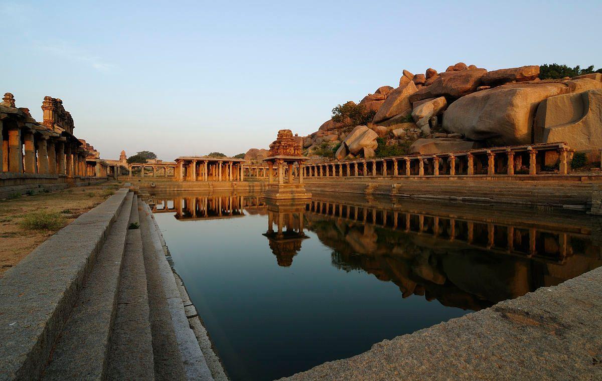
Stepwells and temple tank play a crucial role in the hydrological network of ancient cities and will be described in the following.. Stepwells in India formed an important part of the water management systems, they were an incremental public space and part of a circular system, made from reused materials. Stepwells were common across north-western-central India and in South India. They were a common piece of water infrastructure for several millenniums. In the Mughal period there was a decline in the construction of such structures and during the British era the construction of stepwells was completely stopped. The British Raj saw stepwells as unhygienic, as it serves as a public place. In Ancient India stepwells were part of an intrinsic network of the irrigation system, which considered climatic variabilities between regions, predicted rainfall and groundwater recharge. A stepwell was usually constructed in arid or semi-arid regions and built according to the condition of the soil, water depth and soil erosion (Selvaraj et al, 2022) Every region in India had its own technique and practice of water harvesting (Selvaraj et al, 2022). Such as the Apatani in Arunachal Pradesh, which cultivated rice and aquacultures on mountain slopes. Other cultures in North-East India practised bamboo-drip irrigation (Das et al, 2012). A “Surangam” is a tunnel dug into a laterite hill rock from which water and moisture arise out. This was particularly common in Tamil Nadu (Ghai,2021). Another important feature of ancient Indian water management are temple tanks, which are usually rectangle shaped wells located in temple complexes. They form an important piece of public space in a village or town, as they offer cool breezes amidst heat and were extremely clean and biodiverse, before the advent of modern water pollution. The were the habitat of diverse forms of aquatic organisms and aquatic plants, which biologically cleaned the water in the tank and therefore made it available for public use. As these tanks were located in temples, they were given spiritual and religious important, taking a dip inside the water is spiritually cleansing and part of important ceremonies. In that way water was not treated as a use and throw product, which it later become during the British colonial era, but it was rather an element, which enhanced life on earth (Ramachandran, 2003). Temple tanks were also used to facilitate the growth of medicinal and herbal plants. The year-long availability of water contributed to positive outcomes in biodiversity, as well, many tree varieties thrived along the temple tanks, which in turn facilitated the existence of several other organisms (Maya, 2003)
15
ABC Water Plan Singapore
Introduction of Singapore ABC Water Plan
Singapore and India are two countries lying in a tropical climate zone and facing similar kinds of challenges. Singapore being a well-developed country has already gone through several phases of evaluating its practices in water management (Tortajada, 2006). From building big concrete canals for stormwater to redesigning meandering rivers, Singapore has changed its idea of water management and design. India is rediscovering the importance of blue spaces, after several years of public space deprivation.
Initially Singapore followed a traditional civil-engineering approach, similar to contemporary India. Many attempts were focused on keeping water away. Reservoirs were closed off to public. The main ambition was to keep the city safe from urban flooding related damage and maintain urban sanitation. They were realistic fears of diseases, like malaria spreading. The post-independent Singapore usually built concrete canals in response to these fears. The Singapore in the second half of the 20th century, was expanding and growing. New towns were coming up and natural areas were concretised, which in turn created a higher likelihood for urban flooding. The view of blue spaces as solely functional spaces changed in Singapore in the 1990s and 2000s. Water bodies were opened up and hard barriers were replaced with softer ones. The drainage reserves were used as
16
Figure 5, Picture of a stepwell in Hampi, Capital of Vijayanagar Empire 15th century (Sandip, 2018).
Figure 5
jogging paths in the initial phases of the paradigm shift. Very similar to the riverfront developments happening in India today. The conservation of mangroves along Sungei Api Api river however, was a first step towards a new direction, in which engineers and architects designed a way to maintain the drainage needs of an expanding city and simultaneously conserving the river and the mangroves. It was a success story, especially because of the coordination between government agencies. The Public Utilities Board of Singapore was transferred out of the ministry of trade and industry and merged into the sewage and drainage department under the environment ministry. This merged all water-related responsibilities in Singapore under the Public Utilities Board. These reforms prepared the stage for ABC Waters programme in 2006.
Singapore had the aim to become water self-reliant, as it was dependent on its neighbours for water resources before. Singapore is a water-scarce city, despite having abundant rainfall hydrological catchment areas are not sufficient for its water supply. As of 2014 Singapore receives its water from Malaysia, desalinated water, recycled water and purified water and the local catchment area. Imported water from Malaysia makes up 40% of the water supply and 20% comes from local water catchment (Schaeffer, 2014). A consequence of aiming for water self-reliance is that the urban area of Singapore became a water catchment area and that required a different mindset than previously followed. The government wants to make 90% of Singapore’s land area a water supply catchment area. Singapore initiated sponge city urban design practices as early as in the 1970s, when stormwater retention ponds were built to irrigate civic gardens. One way of getting the support from members of the public, was to increase public engagement and participation and more importantly of increasing the probability of a rise in property value after the implementation of ABC water projects. As the waterfront views significantly improved after successful ABC water programmes, property values in the area usually have seen an increase, that way more critical resident could be convinced Another way of promoting sponge city urban design is the certification of project as water sensitive projects. In addition, points are given to developers to reward their attempts to build sustainably. Punggol District was one such area where ABC design features were incorporated into the design from beginning onwards.
The initial efforts to gain the confidence of politicians and citizens was not easy. To demonstrate the abilities of the ABC water programme, demonstration projects were undertaken such as the Kolan Ayer. Some engineers were concerned that the water quality would deteriorate after reservoirs would open for leisure activities. Kolam Ayer project was important milestone to try out ideas and learn from them. They were a diverse group of stakeholders involved and the interest in the canals of the area was limited. Many people involved in producing the ABC Water programme said the enthusiasm from citizens before, during and after the project was crucial, to make sure the project was a success. To raise awareness about the ABC Water programme, significant amount of work was necessary and was undertaken under the advice of the permanent secretary of the ministry of sustainability and the environment. An exhibition, a lifestyle magazine, a game show and a mascot of the public utilities board of Singapore were all organized just to promote of the idea of
17
ABC Water design. The acronym “ABC” was also conceived as it was easy to remember and simplified the aims of the programme, active, beautiful and clean (Centre for Liveable Cities, 2017). Singapore’s ABC Water Plan has three components. One is the A for Active, which aim to strengthen the community by creating spaces around waterbodies. The second is B for Beautiful, to establish blue water spaces in the city as aesthetically pleasing sights. The last C connotates that the water in the city is “Clean” and that adequate education takes place to sensitise the population about water pollution (Lim and Lu, 2016).
A so-called 3P network was formed with its own director, with the sole intention of increasing stakeholder outreach. The three Ps were People, Private and Public. A inter-agency working committee was established to manage the inter-relations between different agencies, such as the PUB (Public Utilities Board), HDB (Housing Development Board) and National Parks Board. Every intended step was communicated to other agencies, such as utility agencies or the urban redevelopment authority (URA), before executed. The Urban Redevelopment Authority (URA) is the agency responsible for allocating land for development, to the specific agencies. This also ensured that every project in the city followed the idea of water-sensitive\sponge city urban design. Furthermore, know-how and expertise from different fields is required. The involvement of the private sector was also pivotal in bringing in top architects, engineers, and real estate developers. Partnerships with universities were also promoted to conduct pilot projects and do research. The way the ABC water programme redesigned the way urban planning and design was practiced in Singapore, questions if a general permanent paradigm shift is necessary in the professional field, from the conventional function-based segregation of urban agencies. Maybe the professions were too divided in the past to allow for flexibility and dynamism in urban planning. The support of technical expertise in landscape planning from the National Parks Board was crucial, as the expertise was unavailable in the Public Utilities Board Singapore. PUB was largely made of engineers.
Another initiative was a masterplan to connect parks with each other in Singapore. Several studies in the field of landscape ecology have proved that the interconnectivity of landscapes increases biodiversity and the health of animal populations (Hyseni et al, 2021) (Brudvig et al, 2009). The masterplan proposes 100 projects to be carried out until 2030. There were three catchments drawn out in the masterplan and considering the specificalities of each catchment, a consultant was drawn up. Each catchment has a specific type of predominant land-use, which is inherited to Singapore’s urban planning policies. The Western catchment is predominantly industrial and the eastern/central catchment areas are predominantly commercial and residential. Singapore itself saw inspiration from technical plans made for water sensitive urban design projects in Melbourne (Centre for Liveable Cities, 2017). Undertaking the project had 3 main challenges. One was the existence of a physical barrier to water. Every agency had its own distinctive allocated space and therefore the project required a mindset shift, where the space was managed by several entity but with overlapping boundaries. This integration of the space concluded in a more efficient use of urban space.
18
The maintenance of the ABC Water sites had to be sorted to ensure the long-term success of the programme. This wasn’t always easy as sometimes different contractors only maintained certain parts of a site and ignored others. To sort out these responsivities it was important to clarify who would be responsible for what, as this may not be as obvious. Furthermore, an advantage of ABC Water projects is there low-maintenance. Regular checks were sufficient to make sure no litter clogged up the filtrations systems and the bioswales.
Furthermore, the Public Utilities Board of Singapore trains ABC professionals and includes them in a registry. The ABC Water Plan was launched in April 2006, the first rain garden was built in 2009 and in the same year the first guidelines were published. More and more projects were launched projects in the following years and legislation was set in place to legally require developers to slow down surface runoff. Developers were also mandated to reduce stormwater discharge ABC Water Design guidelines are focused on a 1–3-month storm event and excess water is intended to be diverted into an existing stormwater system, designed for 10-year storm event. The three aims in the projects are Infiltration, Conveyance, Detention and Cleansing. One of the most popular features used are green roofs, green walls, bioretention swales and rain gardens. This was accessed based on an evaluation of the projects on the PUB Website. The guidelines recommend to choose locations with a slight slope of 1-4 meters and also to select a location, where an increased level of groundwater will not be harmful to existing infrastructure, like walkways, or basement parking (Lim and Lu, 2016)
19
Figure 6, Plan of Bishan-Ang Kio Park in Ang Mo Kio Neighbourhood in North Singapore (American Society of Landscape Architects, 2016)
Figure 6
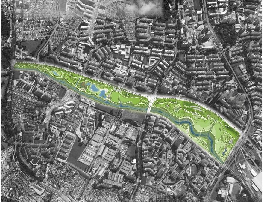
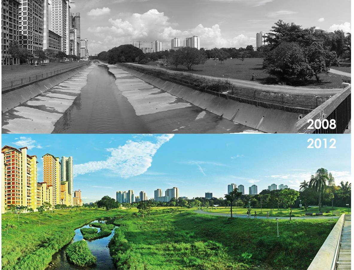
The Bishan-Ang Mo Kio Park along the Kallang River was originally a straight canal connecting Lower Pierce Reservoir to the Marina reservoir, as visible in Figure. 13 (Schaefer, 2014). The Singaporean government had built this canal in the 1960s to curb flooding, therefore natural streams and rivers were converted into canals so that they flow faster out of the city. Unfortunately, in the process the canal created a barrier between two neighbourhoods, was aesthetically unappealing and hazardous, as to be seen in Figure. 13 (An et al, 2020). The canal had fences on its edges, but was still a popular site visited by locals, children would climb into the canal and sometimes during flooding get themselves in dangerous situations (Schaeffer, 2014). As part of the ABC Water Plan the canal was naturalised back into its original form as a river. The naturalised river now serves as a water purifier, flood controller and an amazing recreational and educational space. The plants chosen on the site were specifically scouted. A constructed wetland, a cleansing biotope and several bioswales were installed on the site, to clean the water on reduce its volume. During the design and construction, a big obstacle in the process, was the fear of residents of the water. Residents often demanded physical barriers and engineering solutions, as they were not confident enough about nature-based solutions (Schaeffer, 2014).
20
Figure 7, Pictures of Kallang River before intervention and after (American Society of Landscape Architects, 2016)
Figure 7
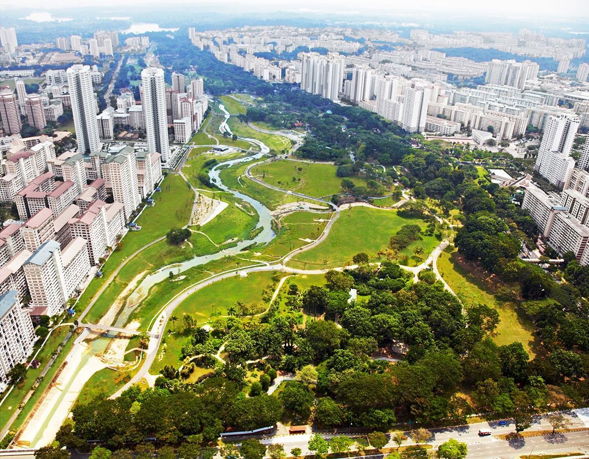
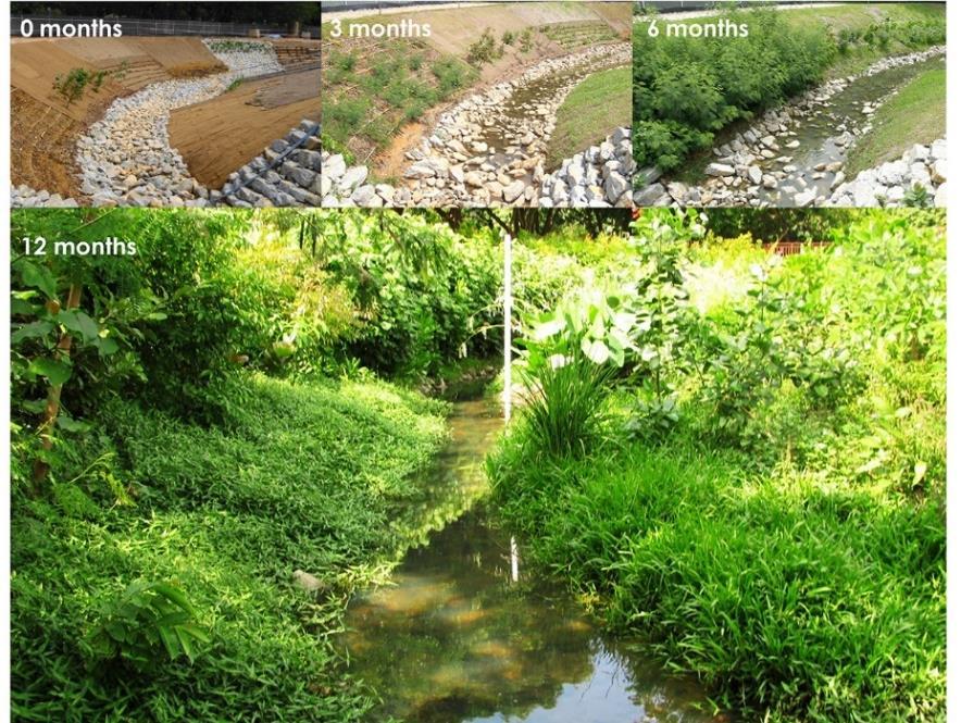
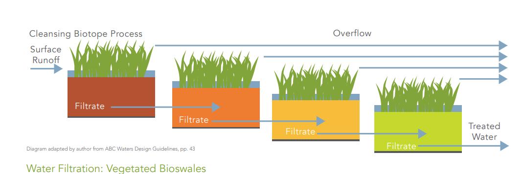
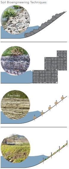
The design of the meandering river, had to ensure that the riverbanks do not get eroded during floods or stronger streams. In nature this process takes place gradually and the vegetation around the riverbanks ensures resilience. However, as this is an engineering redesign project, landscape designers had to incorporate natural features to ensure the same result as in natural ecosystems. This method is called soil engineering. A testbed was created to try out different features. To mimic a natural riverbank 4 kinds of features could be used, as seen in Figure.16 Riprap stones, which is basically a large group of stones. Gabions, stones and soil captured in a metal cage. Fascines, a bundle of young sprouting and unsprouted shootings and Brush mats The park is also designed to be flooded during rains and used as recreational space during dry seasons The material from the old canal was reused to build steps, paths and small buildings in the park, as well as a hill. The Recycle Hill provides a rare topographic experience of Singapore. A large constructed wetland is meant to clean the river-runoff The water runs through 15 different cells and four terraces, as seen in Figure.19. The substrate is nutrient poor and filter out particulates. The mineral compositions bind phosphates out of the water. The vegetation is specially chosen, to clean containments like phosphorus, nitrogen and copper (Schaeffer, 2014).
21
Figure 8, View from above after project completion (American Society of Landscape Architects, 2016)
Figure 8
22
Figure 9, Timeline of Progress: Bioengineering (American Society of Landscape Architects, 2016)
Figure 10, View of Park during flood event (American Society of Landscape Architects, 2016)
Figure 9
Figure 10
Vegetated bioswales play another important role in landscape design, they serve as an important aesthetic feature, simulating a natural landscape in biosphere reserves Furthermore, they serve as pre-filtering before treating the water in the constructed wetlands. Special kinds of grass can also be planted to ensure mosquitos do not breed. Plants can also filter out cadmium and lead from the water (Schaeffer, 2014).
Vegetated swales have the intention to increase sedimentation and improve the water run-off quality (Yau et al, 2017).
Mosquitos are a common problem in the tropics, therefore ABC Water Design Guidelines has strict standards. To prevent breeding stagnant water has to be avoided, mosquito repellent plants can be used or fish can be inhabited into clean water, which eat mosquito larvae. The park has also become a space for improving education among Singaporean residents about ecosystems, flora and fauna. Children were invited to design sculptures, which were later integrated into the park.
23
Figure 11, Different types of bioengineering to prevent erosion and imitate natural riparian landscape (Schaeffer, 2014)
Figure 12, Biofiltration stages (Schaeffer, 2014)
Figure 11
Figure 12
It is also proven that the amount of biodiversity increased in the area, after the redesign of the area. Animals such as the otter, are also commonly visible in an area, where they weren’t very common. Schaeffer from Massachusetts Institute of Technology, USA complains about lack of transparency in the evaluation of the ABC projects, she observed that very few papers existed that criticise or evaluate the ABC Water Plan critically. Despite Singapore not being a free democracy, it is easy to say that the project was a success and an important pioneer in the tropical climate zone (Schaeffer, 2014)
The chief sustainability officer of PUB stressed the importance of doing flagship projects in the initial stages to keep interest from the public high, therefore the Bishan-Ang Mo Park was initiated along the first ABC Water projects. The BishanAng Mo Park project benefitted from the technical advice of landscape architects from the National Parks Board (NParks) of Singapore. The flooding capacity increased in comparison to the previous concrete canal and more space was created for Tai Chi and recreational activities. More importantly the relationship between the residents and the water space has changed, children and adults can dive in and touch the water filled with freshwater fish, where previously a deep concrete channel divided the relationship with water (Centre for Liveable Cities, 2017).
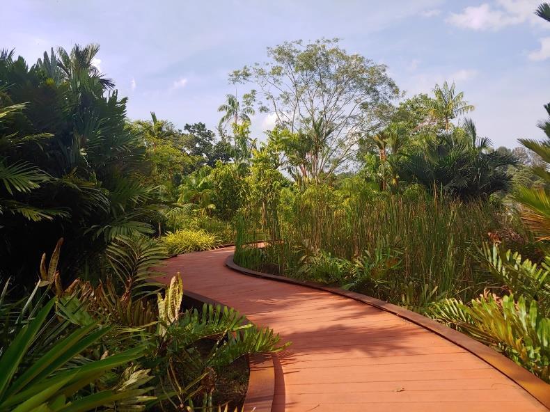
Jurong Lakeside Gardens
Located in the west of Singapore, Jurong Lakeside Garden is an attempt to rehabilitate a freshwater swamp forest. It was one of the pioneering projects, where ABC Water design features were integrated into the masterplan of the neighbourhood, from the beginning. The project has a size of 53 hectares (Holmes, 2022). The project consists of woodlands, wetlands, grasslands and reused materials (Landzine award). The intent was to try to reproduce the condition of the ecosystem, before anthropogenic intervention. This was done in phases. With the first phase involving improving the area’s abiotic elements. In some projects in Singapore, log piles were placed in the area to increase and promote microorganic activity, which internally increases flora and fauna. After that specific types of plants were reintroduced, which were endemic before human intervention. These plant types can be ideal for herbivores, who spread seeds across a landscape or are preferred nesting spots for birds. In the case of Jurong Lake Garden swamp, Alstonia trees were planted (Hwang and Jain, 2021). For recreation, the Jurong Garden has been designed specifically for children and wildlife lovers, with playgrounds simulating the movement of wildlife, who inhabit swamp or marshy areas. The grasslands create a long visual sightline, with meandering walkways along the lake, which bring residents and visitors closer to the flora and fauna. Marshy lands and swamps have a high-level biodiversity and are extremely good carbon sinks (Chmura et al, 2003) (Yang and Yuan, 2018). The site also had 3 300m long straight drainage canals, which as part of the project was converted into several meandering streams, with bioengineered embankments and vegetation typical for tropical delta ecosystems (Landzine, ).
24
Rain Gardens
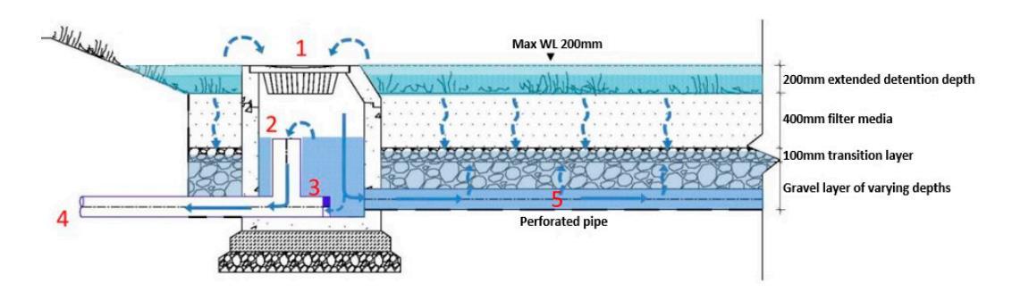
One of the first rain garden projects, as part of Singapore’s ABC Water Plan was the Balam Estate rain garden, at 240m² it covers 4% of its catchment area. It is located in a highly urbanised neighbourhood. The water released from the rain garden is released into the marina reservoir. A rain garden consists of water filter media layers. The first layer is detention ponding layer (100mm), a filtration layer (400mm), a saturated anaerobic zone (400mm) and a drainage layer of (100mm). Anaerobic organisms denitrify nitrogen in the saturated anaerobic layer into nitrogen gas, which makes up the majority of our atmosphere (Cape et al, 2011). According to Lim and Lu, 2016 this rain garden performs well in removing suspended soils (TSS) and nitrogen (TN). One concern from rain garden is leaching, due to higher carbon influx, many organic materials get sedimented in rain gardens and then release concentrated storm wastewater (Lim and Lu, 2016).
A rain garden has different kinds of technical features, which manage, store, and try to absorb the water. A typical rain garden in Waterway Ridges is shown in a crosssection.
25
Figure 13, Jurong Lakeside Garden walkway (Landzine Award, 2016)
Figure 13
The water is allowed to fill the rain garden until 20cm\200mm and simultaneously percolate into the filter media and gravel layer. When the water reaches the bottom of the rain garden it can run-off through percolated pipes. If the water overflows beyond 20cm on the surface, it will overflow into a manhole and drain directly into the percolated pipes. If that manhole overflows as well, the water will overflow into a conventional discharge pipe. Between the manhole basin and the conventional pipes are orifice outlets, which basically regulate the amount of water passing through. The rain gardens at Waterway Ridges have a much thicker gravel layer than other rain gardens in Singapore. Bioretention lawns are similar to rain gardens, however they have a more diverse vegetation and are used as recreational space during dry seasons (Yau et al, 2017).
Green Roofs
Another important aspect of the ABC Water project are green roofs. They can be either extensive and intensive. Extensive collaborates to more shallower vegetation depth. In Singapore intensive green roofs are more common. The retention capabilities of green roofs depend on the chosen vegetation, the climate and the growing media. A study in western Singapore of a green roof with media depth of 120mm, has shown a retention of 57% The average retention of green roofs is between 57% and 68%. However, the capacity of retention is only during the initial rainfall period and reduces drastically with long-intense precipitation. Green roofs do not have a significant role in curbing urban flooding or stopping water run-off, however by increasing the depth of growing media, the retention can be increased. It is noted that in tropical climates, green roofs have a higher retention capability, due to higher temperatures and generally higher biomass. The water quality does not show significant improvements, especially due to fertilisers used in green roof vegetation. Therefore, a green roof must be installed with a thoughtful design, to not make the downstream urban drainages eutrophic (Lim and Lu, 2016). The values of a green roof are more in its ability to reduce air-conditioning costs, reduce airpollution and significantly improve the mental health of urban residents (Morakinyo et al, 2017).
Effectiveness of Singapore’s ABC Water Plan in controlling the quantity of the run-off
Yau et al, 2017 investigates the effectiveness of the ABC Water Plan for controlling and retaining water run-off. The study uses the project called Waterway Ridges as a
26
Figure 14, A cross-section of a typical rain garden in Waterway Ridges, Punggol (Yau et al, 2017)
Figure 14
case study to analyse its effectiveness. The project achieves a run-off coefficient (c) for a 10-year storm event of 0.55. That means 55% of precipitation has run-off our of the site area and 45% of the run-off has been absorbed by the landscape. Yau et al, 2017 used an uncalibrated 1D hydraulic model (Yau et al, 2017). The model (SWMM) was used. SWMM is a simulation model, developed by the United States Environmental Protection Agency (EPA), to simulate surface and subsurface water run-off quantity and quality (Gironas et al, 2010). The results show the design features can reduce the water-runoff by 33% during a 10-year storm event. The authors point out that there is very little modelling of water run-off, due to the fact that the focus of the ABC Water Plan in Singapore is generally kept on improving the water run-off quality and creating recreational space for its citizens. If there is any modelling in place it is usually for assessing the impact of ABC design features on the water quality. Modelling for run-off control has been undertaken in many other countries, such as Australia and the US. There it has proven it be extremely effective, depending on the ratio of the water catchment and bioretention space and depth. The research in this field is very limited in tropical climates (Yau et al, 2017).
The project in Waterway Ridges is a four-hectare space implemented by a join collaboration between the Public Utilities Board and the Housing Development Board of Singapore. The residential development has integrated different types of ABC design features, which is unique in Singapore. The design features include bioretention basins, bioretention lawns, vegetated swales and vegetated swales with a gravel layer. Below the rain gardens and gravel swales there is a 400-750mm thick gravel detention layer. There are 21 rain gardens, 4 vegetated swales and 2 gravel swales (Yau et al, 2017). The research methodology of the study conducted by Yau et al, 2017 focuses first on data collection, then setting up a 1D hydraulic model of the area with the specific ABC Water Plan design features and then to assess the hydraulic performance of the design features. The authors obtained the engineering drawings from PUB and rainfall data for Singapore (Yau et al, 2017).
A dynamic wave hydraulic routing was used to simulate the processes. This technique calculates, in case the water flows reverse in the perforated pipes. The model simulated the 6 different scenario’s ranging from a conventional scenario of no water sensitive urban design\sponge city design features to an ideal design landscape for water detention and absorption. So fictional scenarios were incorporated. The results unearth many conclusions. First, they show that orifice outlets without any ABC design features do not show any effect on the water run-off. Among the design features the rain gardens are the most effective in controlling and reducing water run-off, followed by the gravel swales. The vegetated swales showed the least amount of water absorption ability. The authors however stress that vegetated swales serve other functions such as improving water run-off quality and promoting biodiversity, as well as curbing the urban heat island effect. The results also show that the ABC Design features are more effective in reducing water run-off during 3-month storm events, than in more extreme weather events. The features were able to reduce the outflow by 46.7% in a 3-month storm event in comparison to a 10-year storm event, where the flow reduced by 32.6%, due to ABC design features. In general, the design features narrowly miss the required run-off targets by
27
the legislation in Singapore. However, they could be easily achieved by increasing the width of the orifice outlets, or increasing the size of the rain gardens. (Yau et al, 2017)
The authors conclude that the gravel swales and the orifice outlets are crucial to meet legislation requirements and achieve a coefficient of 0.55. With an increase in the budget by only 3%, an improvement of the performance can be achieved by 11%. Yau et al, 2017 also proved that a minimum of 6% of the site area should be covered by rain gardens to achieve the regulations of c = 0.55. The combination of rain gardens and vegetated swales also helps in curbing the spread of mosquitos and promotes biodiversity, which in turn also can control the population of mosquitos (Yau et al, 2017). The results from Singapore provide valuable data for the implementation of rain gardens, vegetated swales and gravel swales in an Indian context. Cities with similar precipitation intensity and volumes can easily follow strategies followed in Singapore. Cities in India with higher precipitation and highly dynamic precipitation patterns would require additional research and pilot projects to implement similar projects. Different kinds of sponge city infrastructure can be piloted and tested according tot the different conditions of the weather and also be fictionally tested for weather extreme events. One weakness of sponge city projects is their lower impact during weather extreme events. This has been observed in sponge city projects in China (Poon and Torres, 2023).
Methodology
In this thesis we investigated deeper theories and strategies for sponge city practices in India, as this field is under-researched in India and very few examples, which have public prominence. Our aim is to describe what an ideal sponge city in India could look like and what it could inspire itself from. It is a conceptual research approach. The focus is to connect different ideas from different epochs and geographies to provide a conceptual framework for contemporary urban hydrological planning in India.
The type of data needed for this project, was achieved by secondary data. Studies and articles in journals online, which document the hydrological planning in ancient Indian cities or scientific studies on the success and failure of ABC Water Plan projects in Singapore. This methodology is best suitable for the timeframe provided and the scope of expected research. To achieve detailed conclusions, primary data collection would have been a must. The research methodology has research limitations, as a lot of literature on ancient Indian urban planning is yet to be written and few studies have been undertaken to investigate it in detail. Furthermore, Chinese is the predominant language of Singapore and many literature pieces in Chinese or in other local languages have been ignored.
Comparing the contemporary urban landscape design in India with framework
Positive developments can be observed in the urban planning practices of India’s cities, can be seen after 2014. The Ministry of Urban development issued new guidelines after 2014 making it mandatory to plan after considering the blue-green
28
infrastructure of a city and ecosystem-based approaches (Sanchez and Govindarajulu, 2023) Their approaches are slowly coming closer to modern-day nature-based solutions and ancient planning philosophies.
Bengaluru:
K-100 Waterway
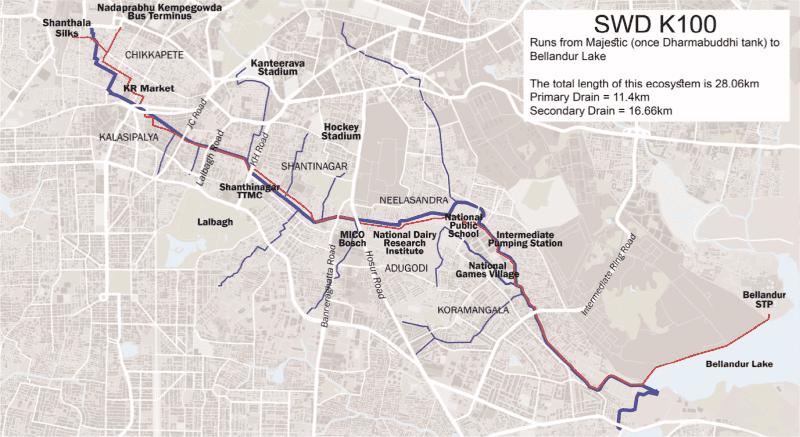
Several stakeholders are realizing the mistakes of initial riverfront projects and are piloting projects across with the aim of closing the knowledge gap with cities like Singapore and Seoul, South Korea. In Bengaluru/Bangalore, the BBMP, has initiated a project in corporation with other private and government agencies to rejuvenate a stormwater drainage canal. The project called “K-100 Waterway” was initiated when the National Green Tribunal of India ordered the stop of urban development of worth 2,300 crore rupees (approx. 278 million USD) and ordered the rejuvenation of Rajakuluves and (Ashok, 2022). The court also ordered a no-development zone buffer of 75 meters, according to D.N, 2016 from the online newspaper “Citizens Matters Bengaluru” (D.N, 2016). The city has a network of 850km of stormwater drainage canals. The aim is to revive the distressing state of canals in the city and create a sense of ownership and responsibility among the citizens of Bengaluru/Bangalore. One of the most important drainage canals is the Rajakuluve, which has a catchment area 32 sq. km. This canal covers the areas of the historic city, the British military cantonment and post-independent urban expansion. Unfortunately, many trunk sewers were built along the stormwater drainage canals (Rajagopal, 2021)
The sedimented silts of the drainage were removed to allows higher volumes of water flow. The plan laid out by the Mod Foundation sets to make the drainage canal into an ecological corridor, which connects through the city, improve quality of fie by providing valuable public spaces and making use of ecosystem service, wherever possible. The most important achievement of the project was the collaboration of several agencies in Bengaluru, like the Storm Water Drain department in the BBMP, the Solid Waste Management department, BBMP, Bengaluru Water Supply
29
Figure 15, Map of K100 canals network (Rajagopal, 20210
Figure 15
Sewerage Board (BWSSB), Karnataka State Natural Disaster Monitoring Centre, Karnataka State Pollution Control Board, Bengaluru Electricity Supply Board and Star Infratech, who implemented the engineering design of the project (BWSSB). Every agency had its role to play, from relaying utilities and protecting for them potential water contact, to undertaking risk assessments of flooding, redirecting sewer tunnels away from the drain, constructing sewage treatment plants, clearing encroachments, and ensuring no solid waste enters the site (Rajagopal, 2021). The tunnelling of the sewage was a considerate success. The urban designer criticises the awareness among public and the lack of public participation, another member of the Mod Foundation Team highlights the importance of bringing the concept of constructed wetlands to India, to treat stormwater before it reaches its main water body (Ashok, 2022). The project is a small success, but the fact that a higher legal institution had to enforce it, is condemnable. Furthermore, it is to observe is a larger watch catchment planning will take place, unfortunately in case of Bengaluru, this is unlikely.
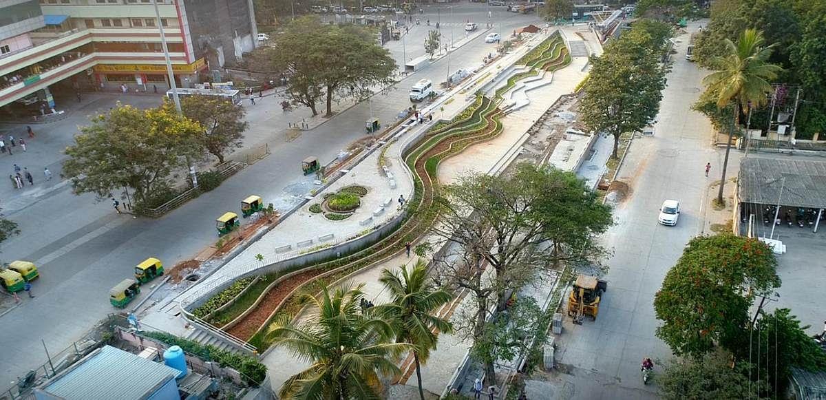
Pune: Mula-Mutha Riverfront Project
There is a visible improvement in the design of riverfront projects even from the same architects and urban designers, as the Sabarmati riverfront development project, such as for the Mula-Mutha Riverfront project. HCP Design proposed a soft edge for the Mula-Mutha Riverfront project between the pedestrian space and the blue space of the river. The same firm was responsible for the design of the Sabarmati riverfront project, with a persistent hard-edge through out the stretch of the river. This design feature adaptation is not highlighted by the firm or politicians in support of the Pune Riverfront project, which would have been beneficial to counter opposition from environmental activists. A soft-edge promotes biodiversity and human interaction with the river, in comparison to a hard-edge. It is important to engage with critics of the project. A challenge for such a debate, is the deep political backdrop in which riverfront projects take place. The relentless pollical competition, sometimes overshadow productive and professional debate, among citizens, as well
30
Figure 16, Picture of Pilot Project Site in Bengaluru (Rajagopal, 2021)
Figure 16
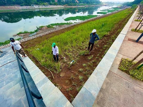
as urban design/planning professionals (HCP Design – Mula Mutha Project) A pilot stretch has been completed in Pune and fortunately the soft-edge has been implemented, these adaptations are commendable.
31
Figure 17, Pilot Project Site of Mula-Mutha Riverfront development Pune (Dhage, 2023)
Figure 17
In addition to the design features, relevant in nature-based solutions urban planning. The planning and regulatory framework on a larger metropolitan level is extremely crucial as mentioned in the Bengaluru K100 project chapter. Planning on a larger can guide smaller interventions effectively and make them politically and economically viable. Due to several constraints and challenges a few cities in India have made the leap in climate resilience. This may not also be intentional, however still commendable.
Delhi: City of Lakes project
The Delhi Jal Board has initiated an interesting project, to increase the water selfreliance of National Capital Territory Delhi. The aim is, like Singapore, to reduce the dependence on water supply from neighbouring states One of the reasons for this project is that Haryana supplies 60-70% of Delhi’s water needs. During an agitation against the Delhi government in Haryana, the main canal was made malfunctional, which affected the water supply in Delhi. This reminds of the motivation of Singapore to become water-self-reliant, due to political differences with Malaysia. The project has its own website and communicates its ambition to develop rejuvenate lakes, rejuvenate drains, decentralise wastewater management and improve wastewater treatment. One such project is the development of the Pappankalan in Southwest Delhi. The Delhi government claims that the groundwater table in the area increased by 4 metres after its conception. The water for the lake comes from an adjacent Pappankalan wastewater treatment plant. Inside the lakes automated aerators have been placed to maintain good-oxygen levels in the lake and promote aerobic digestion among microorganism. The challenges face during the project are specific to the context of the area. Some areas have a higher water table or a lower and the soil characteristics are different. In certain water bodies, water pollution occurs and has to be diverted away before rejuvenation The Sanjay Van Lake rejuvenation project involves the instalment of floating plants wetland plants, to absorb pollutant and organic substance from the water (Matharu, 2023).
Blue green infrastructure: Chennai
Another city compelled to innovate is Chennai, after experiencing devastating floods in the last decade. Citizens have increased their awareness around flooding and it has been realised as a serious threat. The concept of Blue-green infrastructure is been considered more seriously in the masterplan of Chennai. Blue-green infrastructure (BGI) is a combination of natural and anthropogenically designed biome landscapes. These landscapes provide ecosystem services to urban or rural settlements. According to Sanchez and Govindarajulu, 2023 two cities in general have taking a paradigm shift and turned their focus towards BGI, Chennai and Kochi.
In 2017 the Chennai Municipal Corporation collaborated with “100 Resilient Cities” to create a resilience plan after the floods in 2015. In 2019 the CMC identified suitable water bodies for rejuvenation and restoration, including rivers and canals. The Pallikaranai marshland restoration was put under priority, especially because the degradation of this marshland affecting Velachery, an important economic hub of the city. Solid-waste was removed form the marshland and Okkiyam Maduvu, which
32
streams from the Pallikaranai into the Bay of Bengal. An authority to conserve Pallikarani was setup in 2012, but got importance only after the severe floods. The authority got scientific support from NGOs and international agencies. The German financial aid agency, GIZ, setup a competition to collect ideas for the redesign of Buckingham canal. This initiative was part of the Eyes on the canal project. It was a participatory urban planning initiative to include neighbourhood communities and redesign Buckingham Canal to make it more resilient to weather extreme events. 28 contestants participated in the competition. One of the positive outcomes of the entire programme was the increased awareness among public citizens and institutions, as well as the increased coordination of urban agencies. It is being awaited what content the Chennai Masterplan for 2026 and how much input has been taken in from the initiatives and competition. An aspect which Chennai can be lauded is its Resilience Strategy 2019 (Sanchez and Govindarajulu, 2023). The resilience paper mentions under the chapter Resilience Pillars number 1 Urbanising responsibly, the aim to foster a resilience thinking into urban planning paradigms Furthermore, a multi-stakeholder driven planning practice is invigorated. The strategy paper defines 5 pillars of resilience action, urbanising responsibly, water systems, disaster preparedness, governance ecosystem and Chennai’s vulnerable communities. Together with the resilience strategy a resilient office Chennai was also setup, with the chief resilience commissioner. Interestingly the paper mentions the urban horticulture programme as a priority resilience action. The horticulture plan consists of constructing vegetable gardens on public schools and with the help of resident welfare associations across other buildings in the city. The paper proposes to use funds from Smart city Chennai limited and expand existing similar kinds of projects. The primary aim to improve education around recycling resources and ecological resource cycles (Resilience Strategy Chennai, 2019). Another priority resilience action is the “Water as leverage’ concept, by creating hydrological networks inside a city to accommodate water volumes. Among them is a proposal of the Chitra Nagar housing scheme, to funds local initiative to close the water cycle loop. For example, by collecting water, recycling and recharging the groundwater. The subtitle mentions a city of 1000 tanks, this directly reminds oneself of ancient Indian cities, which were spread out with different kinds of tanks. Small and large tanks or publicly accessible tanks to publicly inaccessible tanks, for improved water quality. Analysing the Resilience Strategy of Chennai, as well as the Biodiversity Action Plan of Kochi, in a separate research thesis or paper is highly feasible.
Crucially Govindarajajulu, 2014 suggests a GIS-based land suitability analysis to allocate suitable land for development. The criteria would be based on land use, slope, water features (Govindarajaulu, 2014). To avoid the deterioration of the water catchment encroachments. To improve Chennai’s resilience to urban flooding Rajagopalan, 2017 suggests several measures. First, to create a standard database to collect and information on the impact of flooding in the urban area. Produce risk assessments plans before any planned developments, to allows developers and residents to anticipate the impact of their development. Most importantly integrate all agencies into a larger network and make sure their frameworks complement each other. Like Singapore an educational and awareness campaign will have to be
33
started to attract technical expertise and talent, as well raise the attention of citizens (Rajagopalan, 2017).
Ente Kochi
The Kerala government initiated the Kudumdshree initiative to collect garbage doorto-door and separate the waste, this led to an improvement in the waste disposal into water bodies and open land sites. Kochi is integrating blue-green infrastructure (BGI) step-by-step into it urban planning policies and procedures. Kochi is India’s first city to have a Local Biodiversity Strategy and Action Plan. The Kochi Municipal Corporation and GIZ supported an open urban design competition for Mullassery canal. The local community was heavily involved, with participatory surveys conducted. The local communities brought up issues which may not have been directly evident, such as the spread of a specific weeds, which has inhibited the flow of water in the Mullassery canal or the lack of public spaces along the canal
Sanchez and Govindarajulu, 2023 stress the importance of understanding the catchment hydrology of a city, and simulating to predict future outcomes and plan the most efficient strategies. They also highlight that a mindset shift is needed among the urban administrators to include the scientific community and local community into planning processes (Sanchez and Govindarajulu, 2023)
Conclusion
After looking into the design practices and features of ancient Indian water management and moder-day Singapore, one should be looking at the future optimistically. Reasonably, ancient Indian water management cannot be applied in the 21st century India one-to-one, as the sheer size of modern-day megacities is far beyond anything seen in ancient civilisations. However, they serve as an important inspiration and motivation to implement moder sponge cities, furthermore every region has a different climate and different topography and understanding how our ancestor dealt with water in the specific climates can be useful. Furthermore, in certain cases the revival of ancient hydrological systems can be feasible, as see in the city of Madurai, which has an existent ancient system, which has survived all these years (Aubriot and Prabhakar, 2011).
Many Indian cities do not sufficiently treat their sewage water and do collect their entirely. These are significant inhibitions for sponge city projects, as rain gardens cannot be built if solid-garbage is absorbed onto the site area, this would clog the drainage pipes and make the maintenance financially inviable. Furthermore, if the sewage of streams and nalas is not 100% treated, it can never be transformed into public space or widened into a meandering river such as in Bishan Ang-Ko Park. Therefore, it is important to initiate sponge city masterplans and projects in cities, which are close to achieving 100% solid-waste collection and 100% sewage treatment. Many cities in India have achieved this recently and therefore it is the right time to take the next step and catch up with the best practices in urban flood
34
planning and design (Singh, 2021) (Gupta et al, 2015) It is very important for a city to also have a positive mindset and political climate towards urban planning in general. Sponge city practices or water sensitive urban design does not always work that well under compulsion as seen in Bangalore. It is yet to be seen if Bangalore’s K100 project will follow resemble the ABC Water Plan in Singapore.
The biggest takeaway from ancient Indian urban wate management as mentioned in the abstract is the design philosophy followed. A city was not designed to tame nature, but became a part of it. Natural landscapes were seen as the senior urban planners guiding the human urban planners how to layout their cities. These ideas fit into the larger of ecocentrism (Washington et al, 2017). Ecocentrism as summarized by Gray et al, 2018 is giving priority to the need to the larger ecosystem and following the needs of living organism on secondary basis. Ancient India however had a much lesser ideological or political approach to ecocentrism. Neither was there any term to define, as it was just the standard way of doing things. Furthermore, it was deeply connected with Indian culture and spirituality (Vijaykumar et al, 2019). It will be the task for 21st century India to regain these philosophies and making it the method of operating.
Worldwide cities follow 3 types of planning strategies in response to an increase in weather extreme events. The first is the engineering resilience approach, such as levees, dams or embankments. The second is prediction, prevention and making policies to curb the negative impacts of climate change, by compensating victims of urban flooding for example. This can also include warning systems at flood-prone neighbourhoods or evacuations masterplans. The third focuses on climate resilience and has the aim make sure a society can absorb natural hazards, without any harm done. Essential basic service and functions are preserved or are restored to its original form in a timely and efficient. In addition, the natural hazards can become a strength of the community or society and can improve the dynamics of urban life, thereby losing its classification as a hazard (Sethi et al, 2021). Cities around should institutionalise the third approach. Worldwide 12.1% of urban initiatives are based around adaptation and resilience (Sethi et al, 2021) Sethi et al, 2021 investigates climate trends and intends to propose adaptions measures based on local-climatic conditions. The authors criticise the lack of a nation-wide policy to guide climate adaptations measures across India.
An ideal Indian city should seek inspiration from both directions and get itself inspired to create unique water management practices adapted to the specific climates of an urban area. Each climate zone in India has unique challenges and opportunities. Micro climates inside cities also have their individualities. For example, an interesting pattern of rainfall has emerged in Central India, has seen an increase in extreme rainfall events, especially around the region of Madhya Pradesh (Roxy et al, 2017). The ABC Water Plan guidelines and engineering procedures serve as an important framework for sponge cities in India. Every design feature of a sponge city in India, such as rain gardens, vegetated swales, gravel swales, bioretention ponds, constructed wetlands and river restorations should have specific studies and surveys to understand its effectiveness in every climate context of the Indian subcontinent.
35
Bibliography:
American Society of Landscape Architects, 2016. Bishan-Ang Mo Kio Park. [Online[. [Accessed 12 August 2023]. Available from: https://www.asla.org/2016awards/169669.html
An, Z., Chen, Q. and Li, J., 2020. Ecological strategies of urban ecological parks–a case of Bishan Ang Mo Kio Park and Kallang river in Singapore. In E3S Web of Conferences (Vol. 194, p. 05060). EDP Sciences.
Anand, A., Sreevatsan, A. and Taraporevala, P., 2018. An overview of the smart cities mission in India. Centre for Policy Research, New Delhi, pp.1-17.
Arnaud, F., Schmitt, L., Johnstone, K., Rollet, A. J., & Piégay, H. (2019). Engineering impacts on the Upper Rhine channel and floodplain over two centuries. Geomorphology, 330, 13-27.
Aubriot, O. and Prabhakar, P.I., 2011. Water institutions and the'revival'of tanks in South India: What is at stake locally?. Water Alternatives, 4(3).
Biodiversity Action Plan Kochi, 2020. Kochi Municipal Corporation collaboration with Interact-Bio and German federal ministry. [Online]. [Accessed 12 August 2023].
Available from:
file:///C:/Users/zudi1/Downloads/KochiLBSAP_abridgedversion_lowres.pdf
Bhaduri, A. 2013. Ahar pynes, traditional flood water harvesting systems can help revive agriculture in south Bihar. India Water Portal. [Online]. [Accessed 12 August 2023]. Available from: https://www.indiawaterportal.org/articles/ahar-pynestraditional-flood-water-harvesting-systems-can-help-revive-agriculture-south Bloch, E., Keppens, M. and Hegde, R. eds., 2009. Rethinking religion in India: the colonial construction of Hinduism. Routledge.
Bratman, G.N., Hamilton, J.P. and Daily, G.C., 2012. The impacts of nature experience on human cognitive function and mental health. Annals of the New York academy of sciences, 1249(1), pp.118-136.
Brudvig, L.A., Damschen, E.I., Tewksbury, J.J., Haddad, N.M. and Levey, D.J., 2009. Landscape connectivity promotes plant biodiversity spillover into non-target habitats. Proceedings of the National Academy of Sciences, 106(23), pp.9328-9332.
Cape, J.N., Cornell, S.E., Jickells, T.D. and Nemitz, E., 2011. Organic nitrogen in the atmosphere Where does it come from? A review of sources and methods. Atmospheric Research, 102(1-2), pp.30-48.
Centre for Livable Cities, 2017. Urban System Studies – The Active, Beautiful, Clean Waters Programme: Water as an Environmental Asset. [Online]. [Accessed 12 July 2023]. Available from: https://www.clc.gov.sg/docs/default-source/urban-systemsstudies/rb172978-mnd-abc-water.pdf
36
Chen, Chi-Feng; Sheng, Ming-Yang; Chang, Chia-Ling; Kang, Shyh-Fang; Lin, JenYang (2014). "Application of the SUSTAIN Model to a Watershed-Scale Case for Water Quality Management". Water. 6 (12): 3575–3589. doi:10.3390/w6123575 ISSN 2073-4441
Chmura, G.L., Anisfeld, S.C., Cahoon, D.R. and Lynch, J.C., 2003. Global carbon sequestration in tidal, saline wetland soils. Global biogeochemical cycles, 17(4).
D’Souza, R., 2006. Water in British India: the making of a ‘colonial hydrology’. History Compass, 4(4), pp.621-628.
Dahake, S. 2017. Godavari: Worshiped, Destroyed & Forgotten River of Nashik. Sandrp, [Online]. [Accessed 12 August 2023]. Available from:
https://sandrp.in/2017/12/24/godavari-worshiped-destroyed-forgotten-river-of-nashik/ Dahake, S. 2018. ‘Fixing’ the River: Political Ecology of Changing Water Flows and Infrastructuring along the Godavari Riverscape in Nashik. Engage. [Online].
[Accessed 12 August 2023]. Available from:
https://www.epw.in/engage/article/%E2%80%98fixing%E2%80%99-river-politicalecology-changing-water
Dahake, S. 2022. ‘Fixing’ the River: Political Ecology of Changing Water Flows and Infrastructuring along the Godavari Riverscape in Nashik. Engage. [Online]. [Accessed 12 August 2023]. Available from:
https://www.epw.in/engage/article/%E2%80%98fixing%E2%80%99-river-politicalecology-changing-water
Das, A., Ramkrushna, G.I., Choudhury, B.U., Munda, G.C., Patel, D.P., Ngachan, S.V., Ghosh, P.K., Tripathi, A.K., Das, S. and Kumar, M., 2012. Natural resource conservation through indigenous farming systems: Wisdom alive in North East India.
Dempsey, N., Jayaraj, S.R. and Redmond, E., 2018. There’s always the river: social and environmental equity in rapidly urbanising landscapes in India. Landscape Research, 43(3), pp.275-288.
Dev, N. 2022. Sabarmati Riverfront: A fairy tale of urban transformation. Organiser. [Online]. [Accessed 12 August 2023]. Available from:
https://organiser.org/2022/09/21/94613/bharat/sabarmati-riverfront-a-fairy-tale-ofurban-transformation/
Dhage, C. 2023. Mula Mutha Riverfront Development Project, #Pune A first stretch is under progress as pilot project. Twitter. [Online]. [Accessed 12 August 2023].
Available from: Chandrashekhar Dhage on Twitter: "Mula Mutha Riverfront Development Project, #Pune. A first stretch is under progress as pilot project.
https://t.co/HVv2o5aGDy" / X
Dutta, V., Sharma, U., Iqbal, K., Kumar, R. and Pathak, A.K., 2018. Impact of river channelization and riverfront development on fluvial habitat: evidence from Gomti River, a tributary of Ganges, India. Environmental Sustainability, 1, pp.167-184.
37
Frantzeskaki, N., 2019. Seven lessons for planning nature-based solutions in cities. Environmental science & policy, 93, pp.101-111.
Gajera, H. and Sutaria, D. [No date]. Riverfronts with Ravines: A case of Sabarmati River in Gandhinagar. [Online]. [Accessed 12 August 2023]. Available from: https://www.researchgate.net/profile/DipaniSutaria/publication/367189471_Riverfronts_with_Ravines_A_case_of_Sabarmati_Ri ver_in_Gandhinagar/links/63c635af6fe15d6a5726afae/Riverfronts-with-Ravines-Acase-of-Sabarmati-River-in-Gandhinagar.pdf
Ganesan, M., 2008. The temple tanks of Madras, India: rehabilitation of an ancient technique for multipurpose water storage. Indian journal of science and technology, 1(7), pp.1-8.
Gangopadhyay, B.K., 2020. Historicity of the Mahabharata and the most probable date of the Kurukshetra war. Sovarani Memorial College, Jagatballavpur, India, Tech. Rep.
Ganguly, S. 2015. The transformation of Sabarmati from a parched riverbed with puddles of industrial effluents to a bustling, swanky riverfront. The Economic Times. [Online]. [Accessed 12 August 2023]. Available from: https://economictimes.indiatimes.com/news/politics-and-nation/the-transformation-ofsabarmati-from-a-parched-riverbed-with-puddles-of-industrial-effluents-to-a-bustlingswanky-riverfront/articleshow/45998310.cms
Ghai, R. 2021. Fate of Afghanistan’s karez system uncertain, but south India’s surangam thriving. Down to Earth. [Online]. [Accessed 12 August 2023]. Available from: https://www.downtoearth.org.in/news/water/fate-of-afghanistan-s-karezsystem-uncertain-but-south-india-s-surangam-thriving-78584
Gironás, J., Roesner, L.A., Rossman, L.A. and Davis, J., 2010. A new applications manual for the Storm Water Management Model(SWMM). Environmental Modelling & Software, 25(6), pp.813-814.
Govindarajulu, D., 2014. Urban green space planning for climate adaptation in Indian cities. Urban climate, 10, pp.35-41.
Gupta, N., Yadav, K.K. and Kumar, V., 2015. A review on current status of municipal solid waste management in India. Journal of environmental sciences, 37, pp.206217.
Holmes, D. [No date]. Jurong Lakeside Gardens. World Landscape Architect. [Online]. [Accessed 12 August 2023]. Available from:
https://worldlandscapearchitect.com/jurong-lakeside-garden-singapore-rambollstudio-dreiseitl/?v=c86ee0d9d7ed
Hwang, Y.H. and Jain, A., 2021. Landscape design approaches to enhance human–wildlife interactions in a compact tropical city. Journal of Urban Ecology, 7(1), p.juab007.
38
Hyseni, C., Heino, J., Bini, L.M., Bjelke, U. and Johansson, F., 2021. The importance of blue and green landscape connectivity for biodiversity in urban ponds. Basic and Applied Ecology, 57, pp.129-145.
Idiculla, M. 2021. Who Plans Indian cities development authorities who still follow colonial masterplans. The Print. [Online]. [Accessed 12 August 2023]. Available from: https://theprint.in/opinion/who-plans-indian-cities-development-authorities-whostill-follow-colonial-masterplans/770913/
India Meterologial Department, 2015. Station: Kapurthala Climatological Table 1981–2010" (PDF). Climatological Normals 1981–2010. India Meteorological Department. January 2015. pp. 389–390. Archived from the original (PDF) on 5 February 2020. Retrieved 20 January 2021
Jha, R. 2020. The impact of Gandhi on post-Independence treatment of cities. ORF Online. [Online]. [Accessed 12 August 2023]. Available from:https://www.orfonline.org/expert-speak/the-impact-of-gandhi-on-postindependence-treatment-ofcities/#:~:text=It%20is%20the%20villages%20we,growth%20as%20signs%20of%20 degeneration.
Kayastha, B.L., 2014. Queen of herbs tulsi (Ocimum sanctum) removes impurities from water and plays disinfectant role. J Med Plants Stud, 2(2).
Khan, R., Saxena, A., Shukla, S., Goel, P., Bhattacharya, P., Li, P., Ali, E.F. and Shaheen, S.M., 2022. Appraisal of water quality and ecological sensitivity with reference to riverfront development along the River Gomti, India. Applied Water Science, 12(1), p.13.
Kumar, S. and Singh, R.P., 2013. Waterfront cultural landscape of Ayodhya (India), an ancient sacred abode of Gods. South Asian Affairs, 9(1), pp.6-17.
Landzine International Landscape Award, 2019. Jurong Lakeside Gardens by Ramboll Studio Dreiseitl. [Online]. [Accessed 12 August 2023]. Available from: https://landezine-award.com/jurong-lakeside-garden/
Lim, H.S. and Lu, X.X., 2016. Sustainable urban stormwater management in the tropics: An evaluation of Singapore’s ABC Waters Program. Journal of Hydrology, 538, pp.842-862.
Mashal, M. and Kumar, H. 2021. In India’s water stressed villages, Modi seeks a tap for everyone. New York Times. [Online]. [Accessed 12 August 2023]. Available from: https://www.nytimes.com/2021/12/21/world/asia/india-water-modi.html
Maya, S., 2003. Temple tanks-the ancient water harvesting systems of Kerala and their multifarious roles. Indian Journal of Traditional Knowledge, 2(3), pp.224-229.
MENE, S., TEMPLE TANKS–THE ANCIENT WATER HARVESTING SYSTEM OF CHHATTISGARH AND THEIR MULTIFARIOUS ROLES. 2014.
39
Mohta, P. 2019. ‘a three-generation project’: riverside development divides Indian city. [Online]. The Guardian. [Accessed 12 July 2023]. Available from:
https://www.theguardian.com/cities/2019/jan/16/a-three-generation-project-riversidedevelopment-divides-indian-city
Morakinyo, T.E., Dahanayake, K.K.C., Ng, E. and Chow, C.L., 2017. Temperature and cooling demand reduction by green-roof types in different climates and urban densities: A co-simulation parametric study. Energy and Buildings, 145, pp.226-237.
Nitnaware, H. 2020. Godavari Was Being Buried Under Concrete. Until This Man Fought a 5-Year Battle. The Better India. [Online]. [Accessed 12 August 2023}.
Available from: https://www.thebetterindia.com/238029/devang-jani-nashik-removeconcrete-court-case-river-godavari-riverbed-environment-activist-inspiring-him16/
Nitnware, H. 2020. Godavari Was Being Buried Under Concrete. Until This Man Fought a 5-Year Battle. The Better India. [Online]. [Accessed 16 September 2020].
Available from: https://www.thebetterindia.com/238029/devang-jani-nashik-removeconcrete-court-case-river-godavari-riverbed-environment-activist-inspiring-him16/
No author, 2018. Ancient India Water conservation techniques. [Online]. [Accessed 12 August 2023]. Available from: https://www.chaitanyaproducts.com/blog/ancientindian-water-conservation-techniques-part-1/
Pal, S. 2016. Traditional Water conservation systems India. The Better India. [Online]. [Accessed 12 August 2023]. Available from: https://www.thebetterindia.com/61757/traditional-water-conservation-systems-india/ Pani, N. 2019. Why are urban and rural voters dissimilar. The Hindu Business Line. [Online]. [Accessed 12 August 2023]. Available from: https://www.thehindubusinessline.com/opinion/columns/the-way-people-vote-andwhy/article26913896.ece
Peach, D.A., Almond, M., Gries, R. and Gries, G., 2019. Lemongrass and cinnamon bark: plant essential oil blend as a spatial repellent for mosquitoes in a field setting. Journal of Medical Entomology, 56(5), pp.1346-1352.
Poon, L. and Torries, P.M.T. 2023. CityLab Daily: Extreme Storms Expose Limits of China’s Sponge Cities. CityLab. [Online]. [Accessed 12 August 2023]. Available from: https://www.bloomberg.com/news/newsletters/2023-08-03/citylab-dailyextreme-storms-expose-limits-of-china-s-sponge-cities
Prasad, S. and Parashar, K. 2023. Even as 72.15% of Karnataka electorate vote, Bengaluru sees only 53% turnout, lower than in 2018. Indian Express. [Online]. [Accessed 12 August 2023]. Available from:
https://indianexpress.com/elections/even-as-72-15-percent-of-karnataka-electoratevote-bengaluru-sees-only-53-percent-turnout-lower-than-in-2018-8602738/
40
Raja, R. 2021. Citizens’ Water Way Project: How Bengaluru is revamping the Majestic-Bellandur drain network. Citizens Matter Bengaluru. [Online]. [Accessed 12 August 2023]. Available from: https://bengaluru.citizenmatters.in/all-about-k100stormwater-drain-citizens-waterway-project-69378
Rajagopalan, L., 2017. Integrating climate adaptation into urban development and infrastructure planning in Indian cities: Urban flood vulnerability and responsibility in Chennai, Tamil Nadu, India. Urban perspectives, 50.
Rajasekar, U., Chakraborty, S. and Bhat, G., 2018. Climate resilient smart cities: opportunities for innovative solutions in India. Climate Change in Cities: Innovations in Multi-Level Governance, pp.203-227.
Ramachandran, K., 2006. The sacred spaces of a water culture: The temple tanks of South India. In Third World Water Forum–Water and Cultural Diversity–2003. Tokyo: United Nations Educational Scientific and Cultural Organization (pp. 113-130).
Ramineni, S. and Bharadwaj, M., 2021. Integrated Water Systems in Vernacular Settlements: Temple City of Melukote, Karnataka, India.
Resilience Strategy Chennai, 2019. Resilient Chennai. [Online]. (Accessed 12 August 2023]. Available from: https://resilientchennai.com/wpcontent/uploads/2019/07/Resilience-Strategy_20190703.pdf
Roxy, M.K., Ghosh, S., Pathak, A., Athulya, R., Mujumdar, M., Murtugudde, R., Terray, P. and Rajeevan, M., 2017. A threefold rise in widespread extreme rain events over central India. Nature communications, 8(1), p.708.
Sánchez, F.G. and Govindarajulu, D., 2023. Integrating blue-green infrastructure in urban planning for climate adaptation: Lessons from Chennai and Kochi, India. Land use policy, 124, p.106455.
Sandip, D. 2018. Stepped Tanks of Hampi. Atlas Obscura. [Online]. [Accessed 12 August 2023]. Available from: https://www.atlasobscura.com/places/steppedtanks-pushkarani-hampi
Schaefer, C. 2014. Bishan Ang-Mo Kia Park. MIT. [Online}. [Accessed 12 August 2023]. Available from: https://web.mit.edu/nature/projects_14/pdfs/2014-Bishan-AngMo-Kia-Park-Schaefer.pdf
Selvaraj, T., Devadas, P., Perumal, J.L., Zabaniotou, A. and Ganesapillai, M., 2022. A comprehensive review of the potential of stepwells as sustainable water management structures. Water, 14(17), p.2665.
Sethi, M., Sharma, R., Mohapatra, S. and Mittal, S., 2021. How to tackle complexity in urban climate resilience? Negotiating climate science, adaptation and multi-level governance in India. PLoS One, 16(7), p.e0253904.
Shekhar, L. 2019. In photos: How temple tanks are helping Chennai conserve rain water. [Online]. [Accessed 12 August 2023]. Availeble from:
41
https://www.indiawaterportal.org/articles/photos-how-temple-tanks-are-helpingchennai-conserve-rain-water
Singh, A.P. 2017. Stop Romanticizing Villages! For India to become great, Agrarian Feudal order has to go. Swarajya. [Online]. [Accessed 12 August 2023]. Available from: https://swarajyamag.com/politics/stop-romanticising-villages-for-india-tobecome-great-agrarian-feudal-order-has-to-go
Singh, P.K., Dey, P., Jain, S.K. and Mujumdar, P.P., 2020. Hydrology and water resources management in ancient India. Hydrology and Earth System Sciences, 24(10), pp.4691-4707.
Singh, R., 2021. Municipal solid waste management in the city of Indore A case study. J. Civ. Eng. Environ. Sci, 7, pp.8-17.
Tortajada, C., 2006. Water management in Singapore. Water Resources Development, 22(2), pp.227-240.
Unnikrishnan, H. and Nagendra, H., 2021. Building climate resilient cities in the global South: assessing city adaptation plans in India. The Round Table, 110(5), pp.575-586
UNESCO, 2003. Water and Cultural Diversity. Third World Water Forum. [Online]. [Accessed 12 August 2023]. Available from:
https://sswm.info/sites/default/files/reference_attachments/UNESCO%202006%20W ater%20and%20Cultural%20Diversity.pdf#page=123
Ugra, 2023. There is a description of ancient Ayodhya by Agastya muni in the Skandapurana. He decribes the city very vividly. I tried feeding the information contained in the Shlokas below into AI. The results obtained were quite interesting. [Twitter]. 12 July. (Accessed 12 August 2023). Available from: https://twitter.com/_ugra_/status/1678978810115682304
Van der Meulen, G.J., Bacchin, T.K. and van Dorst, M.J., 2023. Hydrocultural dimension in Water-Sensitive Urban Design for Kozhikode, India.
Vijayakumar, M.C., Paranthaman, G., Rajan, P. and Sridhar, S., 2019. Traces How Many Of Our Historical Values Of Sacred Temple Tanks, Water Resource Engineering Skills Of Ancient Tamils Have We Lost?. Think India Journal, 22(14), pp.6328-6336.
Washington, H., Taylor, B., Kopnina, H., Cryer, P. and Piccolo, J.J., 2017. Why ecocentrism is the key pathway to sustainability. The Ecological Citizen, 1(1), pp.3541.
Wright, I.A., Davies, P.J., Findlay, S.J. and Jonasson, O.J., 2011. A new type of water pollution: concrete drainage infrastructure and geochemical contamination of urban waters. Marine and Freshwater Research, 62(12), pp.1355-1361.
Yang, L. and Yuan, C.S., 2019. Analysis of carbon sink effects for saline constructed wetlands vegetated with mangroves to treat mariculture wastewater and sewage. Water Science and Technology, 79(8), pp.1474-1483.
42
Yau, W.K., Radhakrishnan, M., Liong, S.Y., Zevenbergen, C. and Pathirana, A., 2017. Effectiveness of ABC waters design features for runoff quantity control in urban Singapore. Water, 9(8), p.577.
43
