


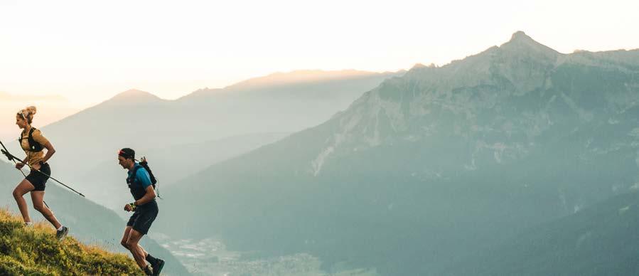
Der Stubai Ultratrail 2025 steht unter dem neuen Motto „EPIC TRAILS. EPIC VALLEY.“ und verspricht ein spektakuläres Trailrunning-Erlebnis im schönsten Tal der Alpen. Der Stubai Ultratrail findet am Wochenende vom 27. bis 28. Juni 2025 statt und führt die Läufer:innen auf 5 unterschiedlichen Distanzen durch die atemberaubende Landschaft des Stubaitals. Alle Strecken beginnen und enden in Neustift, was das Event zu einem wahren Fest für Trailrunner:innen macht.
EN The Stubai Ultratrail 2025 has the new motto “EPIC TRAILS. EPIC VALLEY.” and promises a spectacular trail running experience in the most beautiful valley in the Alps. The Stubai Ultratrail will take place on the weekend of June 27–28, 2025 and will take runners on 5 different distances through the breathtaking landscape of the Stubai Valley. All routes start and finish in Neustift, making the event a real happening for trail runners.
Start, Ziel/Finish: Dorfplatz Neustift
→ 78 km
↓↑ 5.930 Hm
Start, Ziel/Finish: Dorfplatz Neustift
→ 31 km
↓↑ 2.325 Hm
Start, Ziel/Finish: Dorfplatz Neustift
→ 59 km
↓↑ 4.280 Hm
Start, Ziel/Finish: Dorfplatz Neustift → 24 km ↓↑ 1.305 Hm
Start, Ziel/Finish: Dorfplatz Neustift
→ 16 km ↓↑ 750 Hm
Sulzenauhütte (2.191 m)
STUBAIER GLETSCHER
Dresdner Hütte (2.308 m)
Nürnberger Hütte (2.297 m)
Bremer Hütte (2.413 m)
Innsbrucker Hütte (2.369 m)
Neue Regensburger Hütte (2.286 m)
STUBAIER HÖHENWEG
78 km

Franz-Senn-Hütte (2.147 m)
Starkenburger Hütte (2.237 m)
Neustift (985 m)
Der STUBAIER HÖHENWEG ist die ultimative Herausforderung im Herzen der Alpen. Der Lauf beginnt in Neustift im Stubaital und führt dann 78 km und über 5.930 Höhenmeter entlang des bekannten Stubaier Höhenwegs, einem technisch extrem anspruchsvollen, hochalpinem Trail, bevor es schlussendlich wieder zurück nach Neustift geht. Der auf einer Höhe von 2.100 – 2.900 Metern gelegene Stubaier Höhenweg ist geprägt durch 8 Hütten, gepflegte Kulturlandschaften und wilden ursprünglichen Hochgebirgsregionen und bietet somit ein in dieser Art einzigartiges Trailrunerlebnis.
ACHTUNG: Aufgrund der Schwierigkeit der Strecke (hochalpines Gelände, mehrere große Schneefelder, leichte Seil- und Kletterpassagen) müssen gewisse Kriterien von den Läufer:innen erfüllt werden, um sich zum Lauf anzumelden. Näheres dazu auf: www.stubai.at/ultratrail/strecken/stubaier-hoehenweg
EN The STUBAIER HÖHENWEG (STUBAI HIGH TRAIL) is the ultimate challenge in the heart of the Alps. The run starts in Neustift in the Stubai Valley and then leads 78 kilometers and 5,930 meters of altitude along the well-known Stubaier Höhenweg, a technically extremely demanding, high alpine trail, before finally returning to Neustift. Located at an altitude of 2,100 to 2,900 meters, the Stubaier Höhenweg is characterized by 8 huts, cultivated landscapes and wild, pristine high mountain regions and thus offers a unique trail running experience of its kind.
PLEASE NOTE: Due to the difficulty of the route (high alpine terrain, several large snow fields, easy rope and climbing passages), runners must meet certain criteria in order to register for the run.
More details on: www.stubai.at/ultratrail/strecken/stubaier-hoehenweg
Zwölfernieder (2.335 m)
Hühnerspiel (2.185 m)
Milderaunalm (1.671 m)
Autenalm (1.658 m)
STUBAI ULTRA
4.280 Hm
Brandstattalm (1.810 m)
Neustift (985 m) Milders (1.027 m)
START/ZIEL Neustift Dorf (1.000 m)
Hängebrücke (1.320 m)
Starkenburger Hütte (2.237 m)
Galtalm (1.634 m)
Bergstation Elferbahnen (1.794 m)
Fronebenalm (1.306 m)
Der STUBAI ULTRA bietet auf 59 Kilometer und 4.280 Höhenmeter alles, was das Trailrunningherz begehrt! Einmalige Trails und grandiose Aussichten in einer sich ständig ändernden alpinen Landschaft. Zu den Highlights des STUBAI ULTRA gehören der Teilabschnitt zwischen der Milderaunalm und der Brandstattalm, der auch schon bei der WM 2023 gelaufen wurde, die Bergkulisse rund um die Kalkkögel den „Nordtiroler Dolomiten“ und das Elfer-Massiv mit seinen charakteristischen Felstürmen und -zacken.
EN The STUBAI ULTRA offers 59 kilometers and 4,280 vertical meters of everything a trail runner‘s heart desires! Unique trails and magnificent views in a constantly changing alpine landscape. The highlights of the STUBAI ULTRA include the section between the Milderaunalm and the Brandstattalm, which was also run at the 2023 World Championships, the mountain scenery around the Kalkkögel, the „Nordtirol Dolomites“ and the Elfer massif with its characteristic rock towers and pinnacles.

Hühnerspiel (2.185 m)
Milderaunalm (1.671 m)
Milders (1.027 m)
START/ZIEL Neustift Dorf (1.000 m)

STUBAI CLASSIC → 31 km
2.325 Hm
Brandstattalm (1.810 m)
Kaserstattalm (1.890 m)
Hängebrücke (1.320 m)
Neustift (985 m)
Gschmitz (1.360 m)
Der STUBAI CLASSIC ist der nicht minder spektakuläre kleine Bruder des STUBAI ULTRAS. Grandiose Trails und atemberaubende Aussichten verspricht auch dieser Lauf. Nach dem Start in Neustift geht es über die ORIGINAL WM-STRECKE VON 2023 von der Milderaunalm zur Brandstattalm. Nach einem harten Aufstieg bis zur Kaserstattalm geht es schlussendlich über den Sunnenseit’n Weg und der Hängebrücke zurück ins Ziel nach Neustift. Insgesamt müssen 31 Kilometer und 2.325 Höhenmeter bewältigt werden.
EN The STUBAI CLASSIC is the no less spectacular little brother of the STUBAI ULTRA. This race also promises magnificent trails and breathtaking views. After the start in Neustift, the route follows the ORIGINAL 2023 WORLD CUP ROUTE from the Milderaunalm to the Brandstattalm. After a tough climb up to the Kaserstattalm, the route finally takes you via the Sunnenseit‘n Weg and the suspension bridge back to the finish in Neustift. A total of 31 kilometers and 2,325 vertical meters have to be

Milders (1.027 m)
Issenangeralm (1.380 m)
Neustift (985 m)
Neder (980 m)
Kampl (1.000 m)
STUBAI EXPRESS → 24 km
1.305 Hm
Kartnallhöfe (1.300 m)
Hängebrücke (1.320 m)
Pfurtschellhöfe (1.297 m)
Der STUBAI EXPRESS verbindet auf 24 Kilometern und 1.305 Höhenmetern den Sunnenseit’n Trail mit dem wildromantischen Pinnistal und bietet grandiose Aussichten auf beide Seiten des Stubaitals. Die erste Hälfte der Strecke verläuft über den Sunnenseit’n Weg und die spektakuläre neue Hängebrücke. Nach dem Abstieg und der Querung des Talbodens führt die zweite Hälfte über den Besinnungsweg ins Pinnistal. Von dort geht es dann zurück ins Ziel nach Neustift.
EN The STUBAI EXPRESS connects the Sunnenseit’n Trail with the wild and romantic Pinnistal over 24 kilometers and 1,305 meters of altitude and offers magnificent views of both sides of the Stubai Valley. The first half of the route follows the Sunnenseit’n Weg and the spectacular new suspension bridge, and after descending and crossing the valley floor, the second half continues along the Besinnungsweg into the Pinnistal Valley before heading back to the finish line in Neustift.

STUBAI SUNNENSEIT’N TRAIL
16 km
750 Hm
Hängebrücke (1.320 m)
Pfurtschellhöfe (1.297 m)
Der STUBAI SUNNENSEIT’N TRAIL bietet auf seinen kurzen und knackigen 16 Kilometern und 750 Höhenmetern feinste und einfache Trails. Nach dem Start in Neustift geht es über Milders hinauf zu den Kartnallhöfen und dann über den Sunnenseit’n Weg zum Highlight der Strecke, der neuen 105 Meter langen Hängebrücke, die spektakuläre Ausblicke auf die Stubaier Bergwelt bietet. Im Anschluss geht es über Pfurtschell zurück zum Ziel nach Neustift.
EN The STUBAI SUNNENSEIT’N TRAIL offers a short but challenging 16-kilometer route with 750 meters of ascent, featuring some of the finest and easiest trails. Starting in Neustift, the route leads through Milders to the Kartnallhöfe and continues along the Sunnenseit’n Weg to the highlight of the course: a new 105-meterlong suspension bridge that offers spectacular views of the mountains in Stubai. The trail then heads back to Neustift via Pfurtschell.
DATUM/DATE
27.06. – 28.06.2025
STRECKEN/TRAILS
STUBAIER HÖHENWEG → 78 km ↓↑ 5.930 Hm
STUBAI ULTRA
STUBAI CLASSIC
STUBAI EXPRESS
59 km ↓↑ 4.280 Hm
31 km ↓↑ 2.325 Hm
24 km ↓↑ 1.305 Hm
STUBAI SUNNENSEIT’N TRAIL → 16 km ↓↑ 750 Hm
ANMELDUNG/REGISTRATION www.stubai-ultratrail.com/anmeldung
TEILNAHMEGEBÜHR / PARTICIPATON FEE
STUBAIER HÖHENWEG
STUBAI ULTRA
STUBAI CLASSIC
STUBAI EXPRESS
STUBAI SUNNENSEIT’N TRAIL
€ 195,-
€ 145,-
€ 115,-
€ 85,-
€ 50,-
Nachmeldung vor Ort möglich + € 20,–
Late registration on site possible + € 20,–
TVB STUBAI TIROL
Stubaitalhaus, Dorf 3
6167 Neustift i. St., Austria
T +43 (0) 501881-0 info@stubai.at www.stubai.at