THE EXPERIENCE STARTS HERE
Biking in the Stubai valley


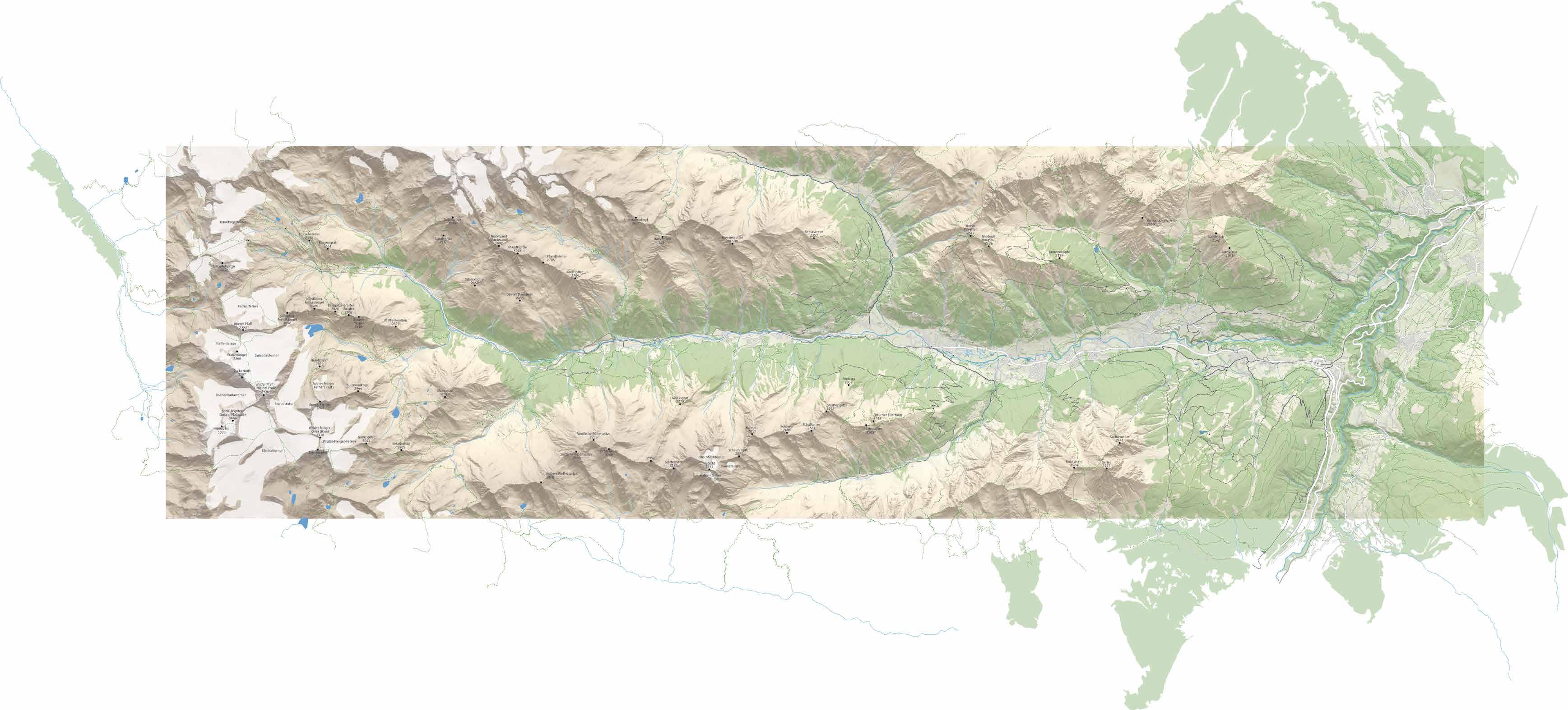
Cycling and mountain biking in the Stubai valley has a lot to offer. You will find routes for every taste and level of difficulty sorted by colors in the following sections.
Cycling track 19 page 12–23
Easy routes page 28–33
Intermediate routes page 36–65
Difficult routes page 68–77
Single trails page 78–81
Important information
Shops, rentals page 82
Guides, adventures, pools page 83
Doctors, pharmacies page 84
Safety instructions page 87
Easy to understand, the following symbols will guide you through the variety of biking options in the Stubai valley.
What the symbols mean:
scenic nature site
train station
swimming pool
gondola
restaurant parking lot
toilets
What the diagrams say:
cycling track 19 easy bike route intermediate bike route difficult bike route single trail route number

With a QR code you are directed to the gpx tracks.

noch 2 km taleinwärts bis zur
Oberiss 1750
1750
Josef 1371
Auffangalm 1620
Bärenbad 1250
Starkenburger Hütte 2237
Gletscherblick
Sennjochhütte 2225
Intersport Martin 1023
Milders
Kaserstattalm 1890
In the mood p. 7
Biking for all p. 9
Cyclists and bikers of all ages are rolling in the Stubai valley.

Cycling track 19 p. 12
Pleasant riding on the cycling track on the valley grounds.


Easy routes p. 28
Family friendly and rideable with all types of bikes.
Intermediate routes p. 36
Sporty mountain bikers will find a new challenge here.
Difficult routes p. 68
Well-trained and experienced bikers can wear themselves out.

Single Trails p. 78
Where one finds action, and a small path is the task. Appendix
Shops, rentals p. 82
Bike guiding p. 82
Adventure, pools p. 83
Doctors p. 84
Pharmacies p. 85
Safety instructions p. 87

For better readability, only the masculine form was used for personal nouns. However, the terms apply to all genders without any bias.


It’s much easier to pedal on when you are looking forward to a nice break with a tasty snack. That is why alongside the Stubai biking routes many delicacies await you.


Above: Action fans will also get their share of excitement in the Stubai valley and have fun. But be aware, flying high is something for experts.
On the left: On flat terrain at the valley grounds, even the smallest cyclists can go on a discovery tour and explore the Stubai valley with the whole family.

It’s time to discover the Stubai valley on two wheels. This valley has a lot more to offer in the summer than just the high peaks that are conquered or the ice giants, that are admired. From the Stefansbrücke on the outskirts of Innsbruck all the way to the glacier, many paths lead bikers to their destination.
Whoever thought, that biking in the Stubai valley is only for tough riders, is wrong. Families and pleasure cyclists are the main group of people in the saddle here. It’s given by the many hotels specialized for families, the BIG family kids’ program and the numerous huts serving local delicacies.
More and more, less-trained bikers reach high on an electric bike. They gather kilometers and meters of vertical height in the whole valley, get to know a lot about nature and culture within a short period of time and do not only charge their bike batteries regularly but also fill up their own resources with tasty food, views, and adventures.
On the paved cycling track 19 at the valley grounds, starting with cycling is possible at any age. With some more experience and shape you can ride on easy and intermediate mountain biking routes to new adventures and views. Well-trained and experienced bikers will find new challenges on black routes, whereas riders focused on the downhill can gear up their fun level on two single trails.
At the hotels, inns, bed & breakfast places as well as apartment houses, cyclists and mountain bikers will always find themselves well accommodated and tended to whatever their preferences are. On days without cycling and for family members who do not ride, there are many alternative activities in the Stubai valley.
Gondolas that carry bicycles, bike shops and rentals as well as bike schools complete the service for bikers in the Stubai valley.
Above on the right: Together, everything is easier. With a little help from their parents, even the little ones get to their next adventure quickly. Below on the right: Water is a constant companion when biking in the Stubai valley. Whether splashing or roaring, it provides variety and refreshment.


Where families and pleasure bikers roll along. No matter if on a balance bike, a road cycle, an electric bike, or a city cruiser – on the Stubai valley grounds all bike fans pedal with no greater effort on the newly build cycling track 19. They are accompanied by impressive mountains, get to know nature and culture, and can taste themselves through a lot of local delicacies at numerous
stops along the way. Next to the cycling track 19, the Ruetz river splashes and provides a fresh breeze while pedaling. The closer it gets towards the glacier, the wilder the river becomes, and the mightier the ice giants seem to reign over the valley. This magical view draws cyclists and bikers inbound and almost let them forget that riding a bike requires some muscle activity.
Discover the Stubai valley quick and easy on the cycling track 19.
Reconstructed and signposted.
The Stubai cycling track 19 is a largely developed, including variations and access roads, about 40 km long cycling path for the whole family. From the starting point in Schönberg to the Doadler Alm in Falbeson, little and big cyclists pedal valley inbound from one adventure to the next without any greater ascent.
Between Kirchbrücke in Fulpmes and Stefansbrücke near Innsbruck, they can also explore an unspoiled scenery. A highlight for all small bikers is the Kids’ Park Klaus Äuele with climbing walls, swinging rope, zip line and much more. But even adults get their efforts worth. They can enjoy the landscape as well as culinary delights and take an active break from everyday life.


Above: The views are invitingly and reward for every effort. Cyclists of any age move forward without having to pedal hard.
On the left: Not only culinary experiences are waiting to be enjoyed at the many resting areas, restaurants, and huts along the way.
Signpost. Continuously marked in green, the cycling track 19 on the Stubai valley grounds lets nobody go astray.

Innsbruck "
Stefansbrücke
cycling track 19
access to cycling track 19
variations cycling track 19
Wipptal cycling track
Through the whole valley. The continuation of the cycling track 19 from Neustift to Fulpmes as well as from Mieders to Schönberg is completed for the most parts. In the direction of Innsbruck, between Kirchbrücke and Stefansbrücke (19a), cyclists can now also enjoy nature and culture. Some parts are not paved
Brenner "
yet and sometimes you have to cross a road, but the track leads continuously from the Wipptal link to the base of the glacier. It is also worth wandering away from the main route and visiting the picturesque villages. There you will find a selection of culinary and cultural options and much more to explore.
23 19 20 21 km 24
!glacier
Playing and having fun. In this section, families should be prepared that they might make more stops than planned and probably won’t reach the Doadler Alm hut at all. The distractions along the track are numerous, and side trips like the one to the “feel good” lake in Milders are not even considered. Alongside the more than 10 km from Neustift towards the base of


the glacier, big and little cyclists meet adventures and temptations in a row, in the form of delicious ice cream, wild waters and many resting and playing areas. At the Kids’ Park Klaus Äuele, attractions like the low rope course or the raft provide enough reasons to leave the little bikes on the ground after all.
Doadler Alm: 1215 m
Total track Schönberg–Doadler Alm
Neustift: 985 m

11 km 14
!glacier
Cool refreshments. No matter if you are cycling outbound or inbound, the envisioned destinations in this section in the summer most likely contain cool refreshments, whether it be cold drinks or delicious ice cream. One of the highlights is the Kampler See lake on the outskirts of Neustift. Playing in the sand or splashing in the water is equally popular there with


the kids as swinging or sliding. While teenagers love to battle at beach volleyball, the adults enjoy a break in the shade of a tree. More water fun is provided at the StuBay indoor and outdoor pools in Telfes. If you aim higher, you will find more challenges in the Schlick 2000 area.
Neustift: 985 m
Total track Schönberg–Doadler Alm
Kirchbrücke: 870 m

Kirchbrücke: 870 m
Schönberg parking: 1051 m
Stefansbrücke: 721 m

Pristine scenery. Even though the connection to the Inntal valley cycling track and therefore to the European cycling track network is not completed yet, and you won’t find restaurants or huts there, it is definitely worth pedaling between Kirchbrücke and Stefansbrücke (19a).
The most unspoiled area of the cycling track 19 will convince you with its lush meadows and deep green forests. You should enjoy the impressive nature while cycling outbound, because on the way back there are some ascents to master which could distract you.
If you choose the southern direction at the Kirchbrücke junction, you not only get to Schönberg and to the start of the cycling track 19 but can also cycle on to the Wipptal valley and over the Brenner pass to Italy from there. However, you have to expect cars as well as ascents and descents after Schönberg.
Easy routes p. 28
Intermediate routes p. 36
Difficult routes p. 68


Mountain biking in the Stubai valley, that mainly means pleasure and easiness, views, and adventures. Everyone is invited to join the ride on two wheels to the next mountain hut or the next scenic nature site, to be there when the views onto the valley reward for the efforts made going uphill and when the slightly different playground is reached after a few vertical meters.
Most of the cycling and biking adventures of the Stubai valley are just around the corner. With a little bit of muscle power, they are easily manageable for all motivated cyclists. Electric power or a kids’ carrier, where the little ones can get comfortable, also help to make everything run smoothly.
Nonetheless, there are routes in the Stubai valley that are challenging too, and where even experienced and welltrained bikers are struggling.

Next to the 3 blue and 14 red routes, 5 black routes are reserved for bikers who want to work out hard and bring experience as well as skills.
The blue routes are family friendly and manageable with all types of bikes. They have a compact, closed track surface. The uphill and downhill gradients are no more than 5 percent. However, you partly have to expect cars and traffic.
The red tracks demand sporty riding. Their uphill and downhill gradients are between 5 and 12 percent. Bikers also have to expect curvy and poorly foreseeable sections –sometimes with vehicles passing.
Black routes are demanding with numerous dangerous sections.
The maximum uphill and downhill gradients are way more than on the red ones, and the routes’ characters are much more difficult. Here, skills and practice are needed.
Single trails are extremely demanding and narrow routes, which only can be ridden with special bikes. There are no-fall-zones and very steep areas, high steps, and roots on the surface as well as rocks. Also expect pushing and carrying sections.

Vergör 1296
1680 Kreuzjochbahn Mittelstation
2000 Talstation 1000
A promising cycling and trekking tour for beginners and the entire family. This bike adventure for both old and young starts at the bottom station of the Kreuzjoch cableway at the Schlick 2000. After about 200 meters on a paved road, the gravel road leading up to the Vergör alpine hut marks the beginning of a new experience on an electric bike or a de-energized cycling passion. It can also appeal to young riders who aim high. As a reward ice cream and a fantastic view onto the Stubai valley await the bikers on the sun deck of the hut. Furthermore, it is only a 30 minutes’ walk to the scenic nature site Gschmitz, where you are easily getting carried away (Hiking booklet p. 38).
Finish: Vergör
Go straight, (right: 585 Almenrunde Schlick → p. 50 and 5006 Starkenburger Hütte → p. 70)
Start of gravel road
After 20 m on paved road go uphill to the right
Start: bottom station of Schlick 2000
start/finish: 1000 m destination: 1296 m


A family cycling trip to a scenic nature site with fun in the pool afterwards. Starting in Telfes, you roll outbound without much pedaling. Even inbound, this route can be mastered by old and young alike, if needed, in a kid carrier or with a little help from the adults. After a short ride, the scenic nature site Telfer Wiesen is a perfect spot to take a break. On the most beautiful larch meadows of Tirol, you can enjoy the sunrays longer than anywhere else and gaze at the rich gentian blossom in the spring. As a special treat for a day in the saddle, a visit to the StuBay – the recreation center with pool, playground and many fun things more – is then highly recommended.
Left to the starting point
Sharp turn left to Niederfeld
Go on straight (left: 100 m to Kirchbrücke)
Keep right (Wiesenhof/no food or drinks)
Start of paved road (Gallhof/no food or drinks)
Turn right ahead of train station
Scenic nature site Telfer Wiesen
Go on right
Parking lot Telfer Wiesen, gravel from here
Go straight uphill on paved road (left: 564 Pfarrachalm → p. 52)
Turn right onto the state road
Start: StuBay


Young and old alike discover nature while cruising through the magical forest. With only one short ascend at the beginning, this tour leads nicely flat through a shady wood from the Schönberg parking lot to Mieders. Quite possible, that you meet the School of Magical Animals out there, while they are having class. So better watch out and take regular breaks along the gravel road to not miss anything exciting at the side. Outbound of the valley, heading back to the starting point, you can take the paved road through the village. If you go fast there, you may roll up easily the last meters of vertical height and overcome that little climb with no greater effort.
Right to Kirchgasse and via the bridge across the autobahn back to the starting point
Go right, parallel to village road
Right to B183 federal road
Go straight to Porzens
Stay right to Oweges
Right to Obere Gasse
Right to Schmelzgasse
Start of paved road
Downhill to the right
Keep left - start of gravel road
Left in the direction of the soccer stadium
Start: Schönberg, go left


Oberhausalm 1350
Gletscherstraße
5082
Falbesoner Nockalm 1663
Doadler Alm 1260
Bushaltestelle Klaus Äuele 1194
Discover the rear Stubai valley and the ice giants on a pleasurable route. Even where the glacier is within a grasp, there are still some rather easy ways to experience the Stubai valley on a bike. From the first parking lot at Falbeson, pedal inbound via the cycling track and the state road. After Ranalt, turn left to Falbesoner Nockalm and pedal on the gravel road up to the hut. But be careful not to go off the track when looking at the stunning and mighty glaciers while cycling. At the Falbesoner Nockalm you must try the Stubai delicacies before you ride back on the same route and eventually add an extra trip to the Oberhausalm when in Ranalt (route 569).
start/finish: 1194 m
Finish: Falbesoner Nockalm
Left on gravel road to Nockalm
Ahead of the parking lot Nürnberger Hütte, turn left onto the gravel road
Left onto L232 state road, go on for 1.5 km
Inbound right, parallel to L232 state road
Right to L232 state road
Right to cycling track 19
Start: bus stop Klaus Äuele
destination: 1663 m


569
Route 5082 → S. 36 Falbesoner Nockalm 1663 Oberhausalm 1350 Bushaltestelle Klaus Äuele 1194
Radroute 19
Doadler Alm 1260
For a short lunch break, as a relaxing extra lap or an easy beginners’ ride. Without greater effort, you can ride to the Oberhausalm at the rear of the Stubai valley. It takes about 30 min. on paved and gravel road from the starting point at the Falbeson parking lot to the destination. Even with children or a kid carrier, this tour is manageable. While the kids then romp around at the playground, the adults can enjoy their after-ride-drink or a Marend – the traditional Tyrolean afternoon snack with bread, cold cuts, and cheese. Outbound there is a short and for everybody manageable single trail, bikers have to overcome, followed by an easy ride on the Stubai cycling track.
Starting point
Left onto L232 state road and back to the starting point via cycling track 19
Highest point 1325 m, start of trail
Oberhausalm
Sharp turn to the left
Turn right (gravel road)
Left onto L232 state road, go on for 200 m
Inbound right, parallel to L232 state road
Right to L232 state road
Right to cycling track 19
Start: bus stop Klaus Äuele


Milderaunalm 1671 Auffangalm 1620
Bärenbad 1250
Stubai Radroute 19 → S. 16
Intersport Martin 1026
Scenically stunning route on a paved road to the Oberberg valley west of Neustift. A rolling wild river, blooming meadows and mighty summits accompany cyclists from Milders to the Oberissalm at the end of the Oberberg valley. The paved road leads past mountain farms and mountain pastures with numerous benches for short stops. At the Oberissalm parking lot, unfortunately there is no riding on. Cyclists have to turn around and roll back on the same route or park their bike and go on by foot to the Franz Senn hut (about 1.5 hrs) or to the Rinnensee lake (about 3 hrs, hiking booklet p. 122). Either way we recommend treating yourself to a delicious Tyrolean dish before.
start/finish: 1026 m
Finish: Oberissalm
Stöcklenalm (no food or drinks)
Ahead of the hut (no food or drinks), right across the bridge
Left across the bridge
Straight uphill in the direction of Bärenbad
Start: Intersport Martin sports shop


Route 568 → S. 40
Josef 1371
Seblaskreuz 2352
Brandstattalm 1810
Hühnerspiel 572
Milderaunalm 1671
Krößbach
Bärenbad 1250
Auffangalm 1620
Intersport Martin 1026
Milders
Stubai Radroute 19→ S. 16
A lap over three alpine pastures with a promising hiking option for strong bikers. This perfect route for a ride with friends starts at the entrance of the Oberberg valley. On paved roads you pass Alt Bärenbad and then move forward on gravel in the direction of Auffangalm and Brandstattalm. Slightly above 1700 m sea level, there is a junction leading to Brandstattalm, which lies only a bit off the main route. This hut marks the highest point of the route and is a perfect stop for refreshments. Easy rolling is on next till Milderaunalm, where the views are also great and the scenic nature site Hühnerspiel is only a 1.5 hrs walk away (hiking booklet p. 44). After that, ride on to Milders and finish the lap.
Back at the starting point: Intersport Martin sports shop
Go straight (right: alternative downhill to Krössbach)
Back on the main route, keep right and go back to Milders
Turn right for Milderaunalm, go on for 600 m
Back on the main route, go right to Milderaunalm
Turn right to Brandstattalm, go on for 700 m
Back on the main route, go left in the direction of Brandstattalm
Go straight for 500 m to Auffangalm
Turn left (start of gravel road)
Go straight Left across the bridge
Straight uphill in the direction of Bärenbad
Start: Intersport Martin sports shop

Freizeitzentrum Neustift 989
Elferlift Talstation 980

Zum Weber Lois 1110
Elferlift
Route 5072 → S. 68
Panorama-
restaurant Elfer 1794
Elferhütte 2004
→Elferspitze
Route 571 → S. 46
Issenanger Alm 1380
A tour for strong legs with an additional summit and a walk-in wooden artwork. As a warm-up you first roll from Neustift to Stackler where you then have to constantly ride up to the top station of the Elfer gondola. Once you have arrived there, enjoy the view and gaze at the brave paragliders, but also visit the special wooden artwork. It is the biggest walk-in sundial of the Alps, measuring 8 m in cross-section dimension. Before ascending the last meters that lead to the downhill ride to Pinnistal valley, mountaineers can add a 2-hours’-hike to the Elfer peak (hiking booklet p. 104) and roll back to Neder and to Neustift via Issenanger and Herzeben mountain hut later.
start/finish: 989 m
Back at the starting point
Right across the bridge to the starting point
Turn left (start of paved road)
Issenangeralm, turn left (right: 571 Pinnistal Karalm → p. 46)
Keep left after the T-bar lift
Highest point reached: 1809 m
Top station of Elfer gondola and Panoramic restaurant Elfer
Turn left (right: 5072 Klamperberg → p. 68)
Weber Lois inn
Keep right
Sharp turn left, start of gravel road (straight: cycling track 19)
Turn left (ahead of the start of cycling track → p. 16)
To the right onto the state road
Start: Neustift recreation center


Freizeitzentrum Neustift 989
Stubai Radroute 19 → S. 16
Klamperbergalm 1795
Autenalm 1665
Zwölferspitze 2562
5072 → S. 68
Panoramarestaurant Elfer 1794
Elferspitze 2505
Pinnisalm 1577 Karalm 1737
Gespaltener Stein
574 → S. 44
Issenanger Alm 1380
Countryside tour for cyclists on electric and nonelectric bikes along a mountain stream to the picturesque Pinnistal valley. Specially at the beginning, either strong muscles or electric power is needed on this tour. Once the climb from Neustift via Obergasse to Neder as well as the gravel road to Issenangeralm are done, it gets easier - time to breathe and admire the diverse nature and cultural landscape. With mighty rock walls to the left, wooded hillsides to the right and a stream next to the road, the tour leads to Karalm, where the valley opens again. Whoever likes to do additional exercise, can add a walk to the Innsbrucker Hütte or a hike to the Habicht summit.
start/finish: 989 m
Finish: Karalm
Pinnisalm
Scenic nature site Gespaltener Stein (cracked rock)
Straight to Issenangeralm
Herzebner Almwirt (no food or drinks)
Turn right to Pinnistal (start of gravel road)
Go straight on Obergasse
Turn left immediately after the bridge
At the traffic circle, inbound across the bridge
Start: Neustift recreation center
destination: 1737 m


Vergör 1296
Schlickeralm 1643
Galtalm 1680
Bruggeralm 1350
Fronebenalm 1306
Schlick 2000 Talstation 1000
Sportive panoramic tour over a few pastures with regional delights. After a couple of meters on paved roads, branch off onto a gravel road towards the Froneben middle station and then go rather steep uphill until you see the Kalkkögel mountain range. At the Schlicker Boden pasture the effort and a side trip to the Schlicker Alm hut will be rewarded. Moving forward to the beautifully located panoramic lake and ascending the last meters to Galtalm, is no problem then. On the way back, just roll down to the valley past Bruggeralm and Fronebenalm.
Back on paved road, going to the starting point
Turn left
Bruggeralm
Galtalm
Turn left (right: 900 m to Schlickeralm)
Go straight (left: 5006 Starkenburgerhütte → p. 70)
Fronebenalm
Turn right (left: 514 Vergör → p. 28)
Start of gravel road
After 20 m, uphill to the right on paved road
Start: bottom station of Schlick 2000


Cycle till late into fall on the sunny side of the Stubai valley to a long-distance view. This intermediate bike tour leads from the StuBay recreation center in Telfes on paved road constantly rising to the Pfarrachalm parking lot, where the gravel road with its wide turns begins. Then, the route goes constantly uphill through woods and meadows to the Pfarrachalm mountain pasture. After satisfying the hunger and the thirst there and enjoying the long-distance view over the Stubai and the Zillertal Alps, you can take a 15 minutes’ walk to a scenic nature site and have fun on a giant swing (hiking booklet p. 50) or add a 2-hours’-hike to the summit of the Saile (2404 m).
start/finish: 987 m
Finish: Pfarrachalm
Turn left after the flat part
Stay right
Go straight Go straight, start of gravel road
Turn left to Pfarrachalm (straight: 563 Telfer Wiesen → p.30)
Turn right onto the state road
Start: StuBay


Wiesen
StuBay 987
Radroute 19 → S. 16
Conquer the Stubai valley from the back on shady climbs. The StuBay recreation center in Telfes is the ideal starting and finishing point for this route too. On a paved road you go to the Telfer Wiesen, where it changes to gravel. Via Stockerhof then move on to Kreither Alm. It is only a two-minute detour from the main route. Although this hut is located outside of the Stubai valley, it also offers Stubai delicacies. About 150 vertical meters later, the route is back in Stubai terrain. Before descending to the valley at the highest point of the tour, enjoy the view. Halfway down you might then even want to extend the tour over the Pfarrachalm (route 564).
Turn left and go back to the starting point
Paved road from here on
Go straight (right: 564 Pfarrachalm → p. 52)
Downhill to the left, highest point 1659 m
Go straight (right: 300 m to Kreitheralm)
Keep left (right: 500 m to Stockerhof)
Go left (200 m of trail)
Go left into the direction of Stockerhof
Telfer Wiesen parking lot, from here on gravel road
Straight uphill on paved road (left: 564 Pfarrachalm → p. 52)
Turn right onto the state road
Start: StuBay


Beginners’ tour, suitable for children, through larch meadows and shady woods. From the first days of spring till the onset of winter, the Telfer Wiesen meadow is a popular destination for easy going bikers and families. They only have to manage a few meters of vertical height through the village before reaching the impressive nature and cultural landscape. From there it is a comfortable ride to Kreith, where the climb to Stockerhof starts. There the little ones are rewarded with a playground, whereas the adults can enjoy a Tyrolean dish and an open view to the Inntal and Zillertal valleys. A short climb after the inn, this nice lap leads all the family back to Telfes.
Back on paved road, go on to the starting point
Go on straight to Telfes
To the left, 500 m to Stockerhof and back
To the left across the bridge
Go straight on gravel
About 300 m after the bridge, sharp turn to the left (paved road)
Keep left (train station Telfer Wiesen, right: 563 Telfer Wiesen → p. 30)
Scenic nature site Telfer Wiesen
Rechts weiter
Telfer Wiesen parking lot, gravel road from here on
Straight uphill on paved road (uphill on the left: 564 Pfarrachalm → p. 52)
Turn right onto the state road
Start: StuBay


Pleasant bike ride with moderate effort and a short section to push. East of the federal road, the old state road leads into the valley and in the direction of Medraz. You can start this tour at the bottom station of the Serles gondola in Mieders. At the Adventure Park in Fulpmes, the route is continuing easy going on gravel. Then the climb up to Sonnenstein follows. We recommend a break and a snack at the inn there because the bike has to be pushed afterwards for about 400 meters to the Klaushof well. At the well, the route leads onto a gravel road which connects it with the routes 556 and 558. Those routes make it both easy to roll back to the starting point.
Back on paved road, go straight to the starting point
Go left on turn 4 of the sledding run
Gravel road
Alpine Inn Sonnenstein, start of pushing section
Sharp turn to the left
Ahead of Medrazer Stille, keep left
Pass the Adventure Park
To the right, start of gravel road
Sharp turn to the left at the end of the meadows
Go straight at Mühltal
Turn left and go inbound on flat terrain
Start: bottom station of Serles gondola


Serlesbahn
Serlesbahn Talstation 960
Speichersee Koppeneck
Koppeneck 1600
Ochsenhütte 1582
Shaded tour for hot summer days with many opportunities for refreshments. The starting point of this tour is the parking lot of the Serles gondola in Mieders. After a short ride outbound through the village, you turn right at the village well and pedal your way up in the shady forest. The gravel road meanders along a pleasant ascent towards Ochsenhütte. From there you then roll over to Koppeneck with no greater effort. Not later than there, it is time to have a break and enjoy the view from the Karwendel mountain range to the Zillertal Alps. The way down to the valley then leads past some chapels, where it is worth stopping or at least riding slowly to have a look.
Back on paved road, go on to the starting point
Turn left ahead of T-bar lift
Ahead of Hirschlacke, downhill to the right (left: about 500 m to the artificial lake and to the Koppeneck restaurant)
Ochsenhütte
Keep right in the direction of Ochsenhütte
Turn left to Gleins
Turn left to Ochsenhütte
Keep right at the junction
Start of gravel road
Right onto Schmelzgasse, then left to Bachleite
Start: bottom station of Serles gondola, go right on paved road to the village well


Serlesbahn Talstation 960
Serlesbahn
Schönberg 1047
Gleinserhof 1412
Ochsenhütte 1582
Queen Serles grants mountain bikers an audience and shows them her view. The greatest effort on this tour is the winding paved road from the Schönberg parking lot up to Gleins. Nevertheless, it needs some endurance to do the queen the honor of visiting. In exchange, bikers get a view on the stunning threepiece rock formation as well as the Stubai valley. Once you have reached the highest point of the tour at the Ochsenhütte, the riding goes on pleasurable to Koppeneck, where on hot summer days you can let your legs dangle in the water. After that, the downhill ride to the bottom station of the Serles gondola and the way back to Schönberg via Mieders is an easy task.
Go back via Kirchgasse and the A13 crossover
Turn right ahead of the toll station (left hand) and go parallel to the village road
Onward on B183 federal road
Go to Porzens, parallel to B183 federal road
Left to Obere Gasse
Turn right to Schmelzgasse at the well
Turn right to the village at the gondola station
Downhill on the right at Bischof-Stecher monument (left: 559 Kreuzweg → p. 76)
Go on straight (right: to the artificial lake and Koppeneck)
Ochsenhütte
Highest point reached: 1670 m
Sharp turn to the left
Gleinserhof inn
Left after 700 m: cycling track 19 Matrei → p. 17
Start: Schönberg


Stefansbrücke 708
Stubai Radroute 19→ S. 16
Mieders
Gleinserhof 1412 Telfer Wiesen
Route 556 → S. 62
Schönberg 1047
Stubai Radroute 19 → S. 16
Enjoy the Stubai and Inntal valley panorama on a pleasurable afternoon ride or a quick evening tour. On this route at the beginning of the Stubai valley bikers in shape start at the Stefansbrücke inn on the old Brenner road and pedal for about 300 vertical meters through the woods on a steep gravel road. It is easier though to start at the Schönberg parking lot (connection to Wipptal cycling track) and ride on a paved and winding road over green fields to Gleinserhof. After enjoying a tasty snack there with a view of the Inntal valley, the fastest way back is on the ascending route. Additional calories can be burned when riding over Koppeneck and Mieders (556).
Finish: Alpine inn Gleinserhof
Go on straight (left: cycling track Schönberg-Matrei → p. 16)
After the Schönberg parking lot (easy starting point), turn right and go straight below the chapel
After the underpass, right into Kirchgasse, then on the bridge across the Autobahn
Turn right to Schulgasse at the first houses
Turn right onto the paved road after the bridge
Turn left at the cross
Go straight on paved road for 200 m
Start: Stefansbrücke inn


Milders
Schaller
Klamperbergalm 1795
Zwölferspitze 2562
1665
Route 574 → S. 44 Freizeitzentrum Neustift 989
0 500 1000 m Panoramarestaurant Elfer 1794
Practicing lap for ambitious mountain bikers and experienced electric cyclists. Like route 574, this tour starts at Stackler and leads towards the top station of the Elfer gondola. After about 400 vertical meters though, it branches off to Autenalm and goes on from there to Klamperbergalm over a very steep climb, which is only manageable for strong bikers and skilled e-bikers. Cyclists without electric power might need to push their bikes there. Be aware that even with electric drive it is technically challenging. The fastest way back is on the same route. At the junction with the route to the top station you can add route 574 to the tour, going via Pinnistal.
0 km
start/finish: 989 m
Finish: Klamperbergalm
Autenalm
Go straight to Autenalm (sharp left: 574 Elfer → p. 44)
Weber Lois inn
Keep right
Sharp turn to the left onto gravel (straight: cycling track 19)
Turn left (go straight for cycling track 19 → p. 16)
Right onto the state road
Start: Neustift recreation center


Hoher Burgstall 2611
Starkenburger Hütte 2237
Vergör 1296
Schlickeralm 1643
Bruggeralm 1350
Fronebenalm 1306
Galtalm 1680
Kaserstattalm 1890 Ruetz
Kampler See B183
Schlick 2000 Talstation 1000
High above the Stubai valley, endurance and stamina are rewarded by the view. Mountain bikers and batteries of electric bikes have to demonstrate long lasting power on this tour. There are quite some meters of vertical height to overcome from Fulpmes via middle station Froneben of the Schlick 2000 resort as well as the Galtalm mountain pasture to the Kaserstattalm. Before reaching the Knappenhütte (closed), the tour becomes technically more demanding, but most of the climb is already done there. At the Starkenburger Hütte bikers fill their stomachs and energy depots to eventually go on a hike to the Hoher Burgstall summit (hiking booklet p. 101) in addition.
start/finish:
Finish: Starkenburger Hütte
Kaserstattalm, afterwards go on uphill on the upper right side
Knappenhütte
Galtalm
Bruggeralm
Turn left (right: 585 Almenrunde Schlick → p. 50)
Fronebenalm
Turn right (left: 514 Vergör → p. 28)
Start of gravel road
After 20 m, uphill to the right (paved)
Start: bottom station of Schlick 2000


Sennjochhütte 2225
Schlickeralm 1643
Zirmachalm 1935
Krinnenköpfe 2139
Kreuzjoch 2136
Kreuzjochbahn Mittelstation
Vergör 1296
Neder-Pfurtschell
Kampler See
A great Stubai view but demanding even for cyclists in good shape. The bottom station of the gondola in Fulpmes is the starting point of this mountain biking challenge. After a few meters on paved road, you have to pedal hard on a gravel road and manage your energy well on the way up to the middle station. Although, the climb becomes more moderate shortly after, you still have a lot of vertical meters ahead. So, better take a break at the Schlickeralm with a view of the Kalkkögel mountain range before going on to the panoramic restaurant Kreuzjoch. Despite the effort already made, you should walk (15 min.) to the lookout platform and stop at the panoramic lake when going downhill.
start/finish:
Finish: Kreuzjoch panoramic mountain restaurant
Turn left (right: alternative route to Sennjoch)
Zirmachalm
Schlickeralm
Go on straight (left: 100 m to the panoramic lake)
Go on straight (left: 5006 Starkenburger Hütte → p. 70)
Fronebenalm
Turn right (left: 514 Vergör → p. 28)
Start of gravel road
After 20 m, uphill to the right (paved)
Start: bottom station of Schlick 2000


Extremely steep and challenging with one of the best scenic views of the Stubai valley. On this difficult tour to Wildeben technical skills and good shape are required. The start is rather easy. From the parking lot of the Serles gondola in Mieders, take the old state road inbound to the Adventure Park in Fulpmes. The following gravel road through the forest to Medraz still does not give a clue of the upcoming struggles. However, shortly after the first houses, an extremely steep track winds its way uphill. Even on an electric bike, a lot of practice is required and after a welldeserved break at the inn, you have to focus once again on the downhill of the same route.
start/finish:
Finish: Wildeben inn
Go on straight (left: 560 Sonnenstein → p. 58)
Ahead of Medrazer Stille, go left
Pass the Adventure Park
Turn right onto gravel
Sharp turn to the left at the end of the meadows
Go on straight at Mühltal
Turn left and go inbound on the flat
Start: bottom station of Serles gondola
destination: 1781


Route 560 → S. 58
Sonnenstein 1400
Serlesbahn
Speichersee Koppeneck Koppeneck 1600
Serlesbahn Talstation 960
Route 558 → S. 60
Ochsenhütte 1582
Klostergasthof Maria Waldrast 1638
Divers tour for riders who are experienced and in shape. Already shortly after the start at the bottom station of the Serles gondola in Mieders, this route winds up to the Waldrast mountain saddle passing stations of the Cross. At the back of the mountain saddle, bikers can not only satisfy their thirst on the Mary’s well, but also eat some regional food at the monastery inn. Strong bikers may then want to go on an additional 2.5 hours’ walk to the summit of the Serles (hiking booklet p. 98) while action fans better save their energy for the trail on the route past the Sonnenstein inn. Less experienced bikers should choose the route past Koppeneck for the downhill.
Back on paved road, go to the starting point
End of the single trail, turn right
Immediately downhill on the right Sonnenstein inn
Start of the single trail
Highest point reached: 1680 m (downhill on the right to Sonnenstein inn, straight for 300 m to Maria Waldrast)
Go straight at the Bischof-Stecher monument
Go straight
Go straight (left: to the artificial lake and to Koppeneck)
Right on turn 2 of sledding run
Start of gravel road, sharp turn left
Uphill on the left (paved) onto Waldrast road
Start: bottom station of Serles gondola
highest point: 1680 m


How about getting a little bit wilder?
For some bike fans, single trails with roots and steep turns are absolutely necessary to have fun when riding. Therefore, at the Elfer in Neustift, where paragliders have found their playground already a while ago, now freeriders, downhill and enduro bikers call the place home too. They can also use the gondola to get to the top fast and easy and can afterwards

choose between two single trails to speed from the top station down to the valley. Of course, at the bottom station they will find the obligatory washing area. However, with skills for level S2 on the single trail scale needed for this adventure, technique and practice are essential. Whoever wants to have fun at the Elfer, has to know how to manage roots, rocks, narrow turns and steep downhills.


The EinsEinser trail starts right below the top station and demands full concentration from the beginning on. Over numerous turns through mostly wooded areas with many roots the 4 km long trail winds its way down. In the lower section there are some drops and north shore elements as well as a wall ride. Even though some smooth parts will bring bikers into a flow, the trail may not be underestimated and is definitely not for beginners.
From the top station, the ZweiZweier trail winds its way down underneath the gondola and sometimes through the woods on natural sections as well as areas with constructed turns and jumps. After 3.5 km it leads into the EinsEinser trail. Although it is mostly bulldozed with few roots, what makes the ZweiZweier trail more flowing, faster, and easier to ride than the EinsEinser trail, skills and practice are needed here as well.
Shops, rentals
in Neustift:
• Sport Stubai
Stubaitalstraße 62
6167 Neustift +43 5226 30288 sport-stubai@aon.at
• Schönherr Sport & Mode
Stubaitalstraße 79
6167 Neustift +43 5226 369043 info@schoenherr.cc

• Sport Hofer
Dorf 13, 6167 Neustift +43 5226 2428 hofer@sport2000.at
• Stubike
Dorf 25, 6167 Neustift +43 650 6359058 info.stubike@gmail.com
• Intersport Martin Milders, Franz-SennStraße 88, 6167 Neustift info@intersport-martin.at +43 5226 23045 in Fulpmes:
• HP-Sports bottom station
Schlick 2000
6166 Fulpmes +43 664 4765650 office@hp-sports.at
• Intersport Pittl bottom station
Schlick 2000
6166 Fulpmes +43 5225 64115 intersport-pittl@aon.at
• Sport Denifl Industriezone C10
6166 Fulpmes +43 5225 62281 office@sportshop.at
• Radsport Steixner Bahnstraße 14 6166 Fulpmes +43 5225 62312 radsport.steixner@eunet.at
Bike guides
• Flat Sucks
+43 664 4254829 info@flatsucks.at
• Earla
+43 512 327277 hallo@earla.at
• Sport Stubai
+43 5226 30288 sport-stubai@aon.at
• Stubike
+43 676 3305112 info.stubike@gmail.com
• Markus Kindl
+43 650 5231909 kindl.markus@gmx.at


Adventure, action
• Adventure Park High rope & tree top courses Gschnalsgasse 3 6166 Fulpmes
+43 664 8644944 info@outdoorprofi.at
• Rafting in the Stubaital
+43 660 7569539 info@stubai-rafting.at
• Alpen-Paragliding-Center Moos 18, 6167 Neustift
+43 5226 3344 flugschule@apc-stubai.at
• Wings of Change Paragliders Waldrasterstraße 6b 6166 Fulpmes
+43 5225 64830 wings-of.change@aon.at
Indoor & outdoor pools, lakes
• Recreation center StuBay
Pools, sauna & airparc
Landesstraße 1
6165 Telfes
+43 5225 62666
info@stubay.at
• “Miederer Badl” pool
Wiesel 3
6142 Mieders
• „feel good“ lake Milders
Franz-Senn-Straße 170
6167 Neustift
• “Kampler See” lake
Stubaitalstraße 22
6167 Neustift

Doctors
• Dr. Turkonje (General practitioner)
Dorf 32, 6167 Neustift
+43 5226 30053
• Dr. Gleirscher (General practitioner)
Stubaitalstraße 104
6167 Neustift
+43 5226 2737
• Dr. Lugmayr/Dr. Ranalter (Sports medicine)
Scheibe 39, 6167 Neustift
+43 5226 2214
• Dr. Somavilla (General pract., orthop.)
Riehlstraße 32b
6166 Fulpmes
+43 5225 62257
• Dr. Gritsch (internal med.)
Riehlstraße 3
6166 Fulpmes
+43 5225 65286
• Dr. Leitgeb (General practitioner)
Lange Gasse 24
6165 Telfes
+43 5225 63823-1
Pharmacies/imprint

• Dr. Nagiller (General practitioner)
Mieders
+43 5226 2973
Pharmacies
• St. Georg pharmacy
Dorf 30, 6167 Neustift
+43 5226 3100
• Stubaital pharmacy
Waldrasterstr. 12
6166 Fulpmes
+43 5225 62070
• Serles pharmacy
Schmelzgasse 2
6142 Mieders
+43 5225 63030
• Publisher: Stubai Tirol
Tourism Association
• Editor: Irene Walser
• Layout & graphic design: Atelier Christian Mariacher
• Graphic design assistant: Daniela Schatz
• Mapping: Pindar
Creative (with Copernicus, OpenStreetMap contributors) and Atelier Mariacher
• Print: Alpina Druck
• Pictures: Flatscher, Dräger, Malin, Parafly Stubai, Schönherr, scisettialfio/ istockphoto.com
No guarantee for completeness or accuracy of all data. All liability for the quality of routes and tracks is denied. No accountability for accidents of all arts.
Riding on the routes and tracks at own risk.


Wayfinding information design Throughout the cycling track 19, not only end-to-end signposting has been installed with a green logo leading cyclists along the entire route. A couple of platforms with benches, a general map, bike racks and tools were also built. They give you an overview of the location as well as the cycling possibilities and invite you to stop and enjoy a break. In 2023, Atelier Mariacher and architect Thomas Mathoy were awarded by the International Institute for Information Design for the quality of their graphic and architectural creation.
Emergency numbers in Austria: fire brigade 122 police 133 ambulance 144 alpine emergency 140
Safety instructions
→ Always ride with controlled speed and within breaking distance of half the sight!
→ Take care of hikers and walkers and pass them with walking pace only!
→ Mind the level of difficulty of the route and rank your own abilities, experience, and skills as a mountain biker within that level!
→ Never ride without a helmet! Check your gear before every ride!
→ Accept closed routes and barriers and do not pass them. Don’t forget that most of the tracks and roads are mainly used by farmers for their daily work. Close farmland fences after passing!
→ Respect nature and animals and stay on the marked routes.
→ For your own safety and that of the animals: finish your bike ride before dawn!
→ Don’t leave garbage behind! Special safety recommendations on single trails
→ Advanced riding skills and technique as well as a helmet and protectors are absolutely necessary!
→ Ride only with special freeride, downhill or enduro bikes on single trails!
→ Stay on the trail and don’t make short cuts! Do not leave skid marks on the trail by blocking back wheels!
→ Pay attention for alpine risks!


