Local and Landscape Determinants of Non-breeding Bird Use of Powerline Rights Of Way
Preliminary Results Fig. 3 Percent land cover surrounding each ROW
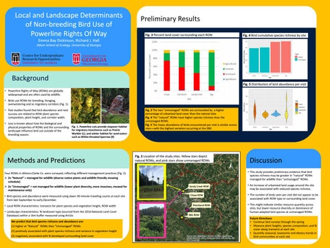
Fig. 4 Bird cumulative species richness by site
Emma Bay Dickinson, Richard J. Hall Odum School of Ecology, University of Georgia
Background Fig. 5 Distribution of bird abundance per visit • Powerline Rights of Way (ROWs) are globally widespread and are often used by wildlife. • Birds use ROWs for breeding, foraging, overwintering and as migratory corridors (Fig. 1). • Past studies found that bird abundance and nest success are related to ROW plant species composition, plant height, and corridor width. • Less is known about how the biological and physical properties of ROWs and the surrounding Fig. 1. Powerline cuts provide stopover habitat for migratory insectivores such as Prairie landscape influence bird use outside of the Warbler (L), and winter habitat for seed-eaters breeding season.
Fig. 3 The two “unmanaged” ROWs are surrounded by a higher percentage of urbanized land cover than the natural sites Fig. 4 The “natural” ROWs have higher species richness than the unmanaged ROWs Fig. 5 The mean abundance of birds encountered per visit is similar across sites—with the highest variation occurring at the SBG
such as White-throated Sparrow (R)
Methods and Predictions
Fig. 2 Location of the study sites. Yellow stars depict natural ROWs, and pink stars show unmanaged ROWs
Four ROWs in Athens-Clarke Co. were surveyed, reflecting different management practices (Fig. 2). ➢ 2x “Natural” = managed for wildlife (diverse native plants and wildlife-friendly mowing schedule)
Fig. 4 Map of Sites in AthensClarke County
Discussion • This study provides preliminary evidence that bird species richness may be greater in “natural” ROWs managed for wildlife than “unmanaged” ROWs.
➢ 2x “Unmanaged” = not managed for wildlife (lower plant diversity, more invasives, mowed for maintenance only)
• An increase of urbanized land usage around the site may be associated with reduced species richness.
• Bird species and abundance were measured using dawn 30-minute traveling counts at each site from late September to early December.
• The number of birds seen per visit did not appear to be associated with ROW type or surrounding land cover.
• Local ROW characteristics: transects for plant species and vegetation height, ROW width
• This might indicate similar resource quantity across sites, but lower resource diversity or dominance of human-adapted bird species at unmanaged ROWs.
• Landscape characteristics: % landcover type (sourced from the 2016 National Land Cover Database) within a 1km buffer measured using ArcGis We predict that bird species richness and abundance are: (1) higher at “Natural” ROWs than “Unmanaged” ROWs (2) positively associated with plant species richness and variance in vegetation height (3) negatively associated with % developed surrounding land cover
Future Directions • Continue bird surveys through the spring • Measure plant heights, species composition, and % cover along transects at each site • Quantify seasonal, taxonomic and dietary trends in bird communities at each site