SRI POORANI SRINIVASAN
selected works 2021-25
selected works 2021-25
Type : Academic (MSUD thesis)
Dates : Aug ‘24May ‘25
Location : Chennai
Instructor : Prof. Dean Almy, Prof. Hope Hasbrouck
Monsoon is a force that changes the winds, the tides, the temperatures, brings rain, and influences the lives of millions of people living on the coast. It is an inherent part of coastal culture and the Bay of Bengal communities depend on it as much as they are affected by it. This research explores the relationship between the monsoon, nature and coastal communities, specifically the fishermen of the city of Chennai.
The geography of coastal cities are a composition of different ecosystems exclusive to the coastal areasmangroves, seagrass meadows, estuaries, coral reefs and coastal
wetlands. Mangroves and seagrass beds act as protectors of the coast because of their roots preventing erosion and rough waves. Wetlands act as sponges and so on. It is when these ecosystems are disturbed by unplanned development, that the city suffers. The city of Chennai is one such case.
The work presented in the portfolio is a part of the research phase of my thesis. I am currently working on is the design phase where I aim to study and ideate nature based ecological revival and design strategies for the fisher communities to combat monsoon and climate change.


Cycles of the monsoon shape the region’s geography, food, culture, and economy. Around 275 million people are engaged in monsoon-dependant economies like agriculture and fisheries. The monsoon influences the timings of harvest, fish breeding and landing, therefore dips and boosts in economies.
Natural events severely damage the coastal
ecosystems too. Mangroves, seagrass, coral reefs and sand dunes sytems inherently protect the coastlines from storm surges and activities of ocean warming, pollution, unplanned development degrade these ecosystems, exposing coastal landscapes to greater climate risks.


The city of Chennai or ‘Madrasapattinam’ was originally a land of scattered fishing villages (pattinam - coastal town). There’s literary and geological evidences of huge portions of mangroves, sand dune systems and mudflat ecosystems which have now been reduced drastically due to urbanization.
“Eri’s are the man-made water tank systems of the majorly rain-fed region. A vital source of water, these were deemed as ‘porambokku’ or common land preserved to public use. Over time, they’ve been misused and converted to private parcels leading to unplanned development and degradation of water sources.
The Buckingham canal was constructed for transportation of goods in the British era. The increased sewage outflow into the canal and its negligence has reduced its storm-water bearing capacity and quality of life. The construction of the Chennai harbour has led to coastal erosion by waves to the North of the harbour.

Industrial land use pollute the Ennore creek biodiversity and cause harm to lives of people
Construction of harbour leads to coastal acretion and erosion
1923 Mambalam Housing Act Tank breached to provide 1600 acres of housing
Sewage discharge and waste disposal pollute the Adyar estuary depleting its mangrove resources. Adyar Eco-Park a move to restore the lost fauna and flora.
Waste dumping, sewage discharge and building construction shrunk the Pallikaranai wetlands to a great extent. In 2007, declared a protected forest area.
existing fisher settlement prone to tidal flooding

existing coastline
attenuate
settlement relocated
high marsh planted buffer zone
Adyar inter-tidal waters
Adyar inter-tidal waters lined with mangroves
narrow footpath
footpath extension
existing canal
waterfront buffer
construction of the harbour in 1881 led to erosion and pollution of the coast to the North of the port
low marsh
wave attenuation by breakwater and marsh buffer reverses coastal erosion
existing fisher settlement prone to tidal flooding
restoration of native sand dune landscape for coastal protection
Greenways roadarterial road of the Quibble island
extension and preservation of mudflat territory increases biodiversity and controls storm surge
extending footpath and adding bioswales for stormwater management
incorporating rain garden in the OSR space in building
concretized Captain Cotton canal with settlements right on the edge prone to damage from surge
canal embanked with vegetation to filter and slow down runoff. pedestrian bridge to activate waterfront

flooding and vulnerable fishing villages

proposed relief centers and mudflat attenuation
Estuary to mudflats
Estuary to Mudflats offers the reintroduction of native dune landscape (prevelant along the coast) that acts as a natural barrier for winds and waves. The preservation of existing mudflat terrain and mangrove biodiversity also provides the means for flood mitigation and a supportive economy for the fisherfolk through ecotourism and care incentives.
flooding and coastal erosion

proposed preservation and living breakwaters
Wetland to Coastal Marsh project extends on the same and strengthens the network of stormwater drainage from wetlands to the ocean through dispersion strategies of street and canal porosities. It identifies areas of communal significance and ties them with the stormwater strategies like vegetative buffer, rain garden, and bioswales. Living breakwaters that form an internal buffer is used to counter-act the erosion, along with marsh biodiversity.
Type : Professional architectureRED
Dates : Sep ‘22Jan ‘22
Location : Chennai Supervisors : Biju Kuriakose, Kavya Suresh
Role : site surveying, client meetings, design concept, drawings, 3d modeling and report
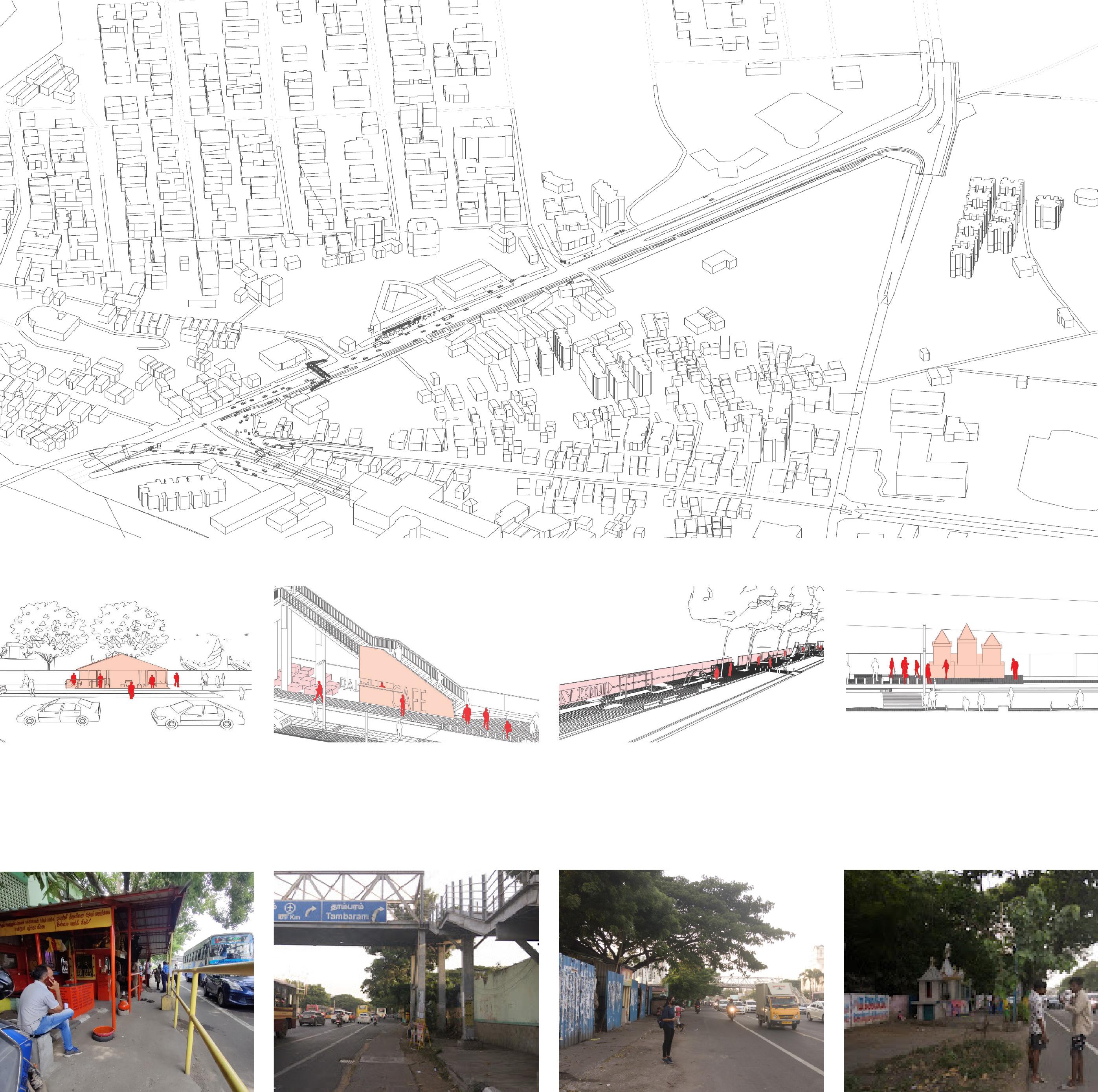
The Chennai Megastreets Project is a project undertaken by Greater Chennai Corporation (GCC) to redesign and develop streets in Chennai to be futureready and prioritised for non-motorised transport. The designs will incorporate various aspects of mobility, utility and livability.
The vision for this project therefore draws on this notion of Adyar being both a place as well as a portal and seeks to strengthen these identities as manifested in its street network through the power of placemaking.
The Taluk road is one of the gateways to Adyar, is a ceremonial path terminating at the Raj Bhavan junction. As it functions as an entry point to Adyar, there’s high vehicular movement. The proximity of major transit nodes and the presence of large green spaces makes it a heavily pedestrianised street. The vision is to make the path an active people’s place, while increasing the road safety. This is achieved by identifying and linking potential social zones that can create an identity for the locality.


streetscape - building heights and zoning
Existing temple is articulated with a pedestrian friendly neighborhood with better seating, cycle track and landscape.
Existing Foot over bridge is activated by introducing catalysts like cafes and seating.
A linear park with play area for kids and an open gym is intergrated along with landscape in the ecological park
The existing church shrine is articulated by defining pedestrian paths and seats around.
Parallel parking lanes and 4 lane vehicular route
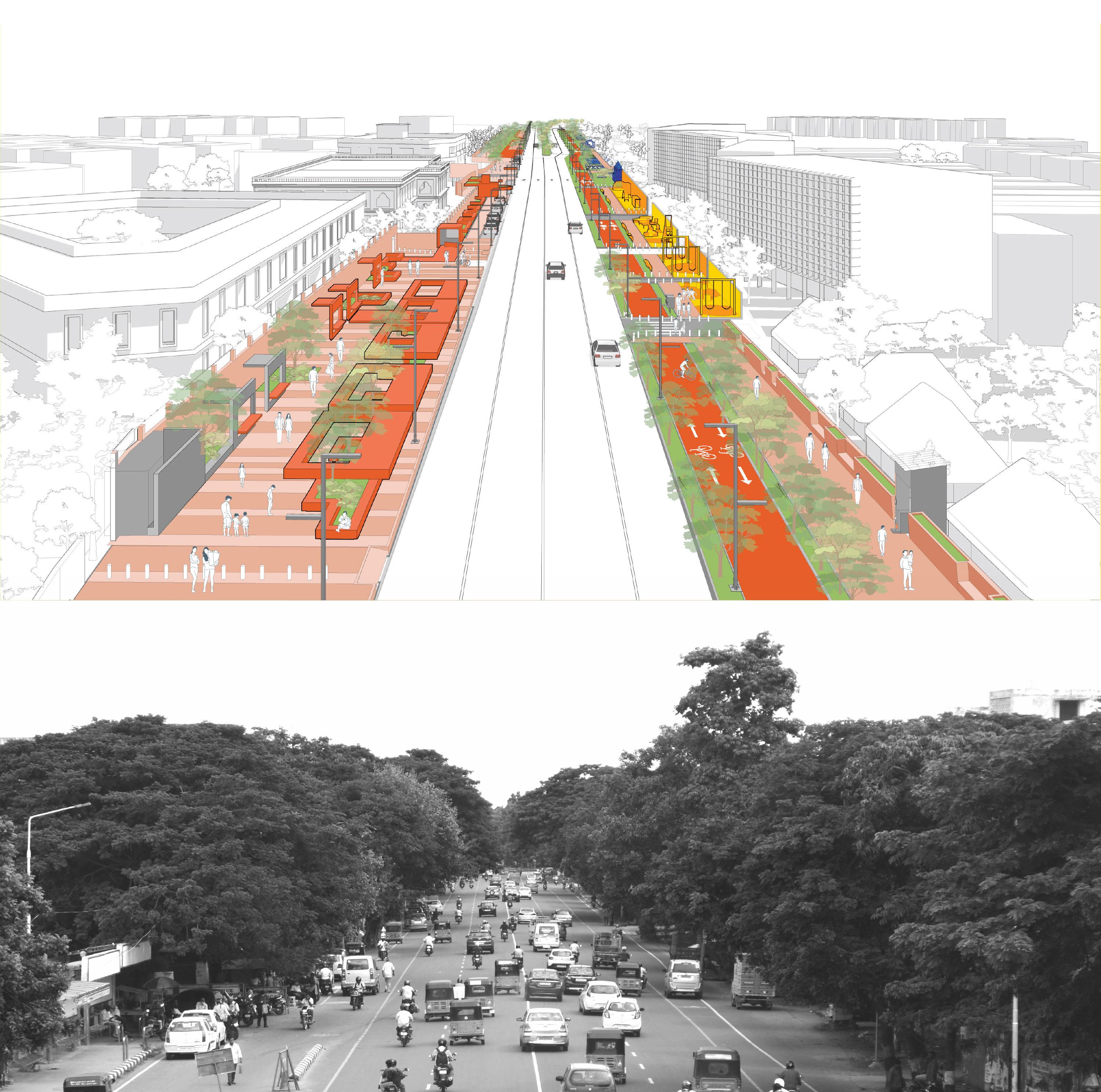
Ramps and raised crossing for differently abled
streetscape - pedestrianized Taluk Road
Designated cycle track and parking

Spillover of daily activities from the magistrate courts in the form of small stalls, shops and seating spaces requires the extension of the pedestrian pathway and the walkability of the bus stop in turn boosts the vendor economy.


Housing park space
Type : Professional Dates : Aug ‘24
Location : New York
Supervisor :
Runit Chhaya, Kate Belski
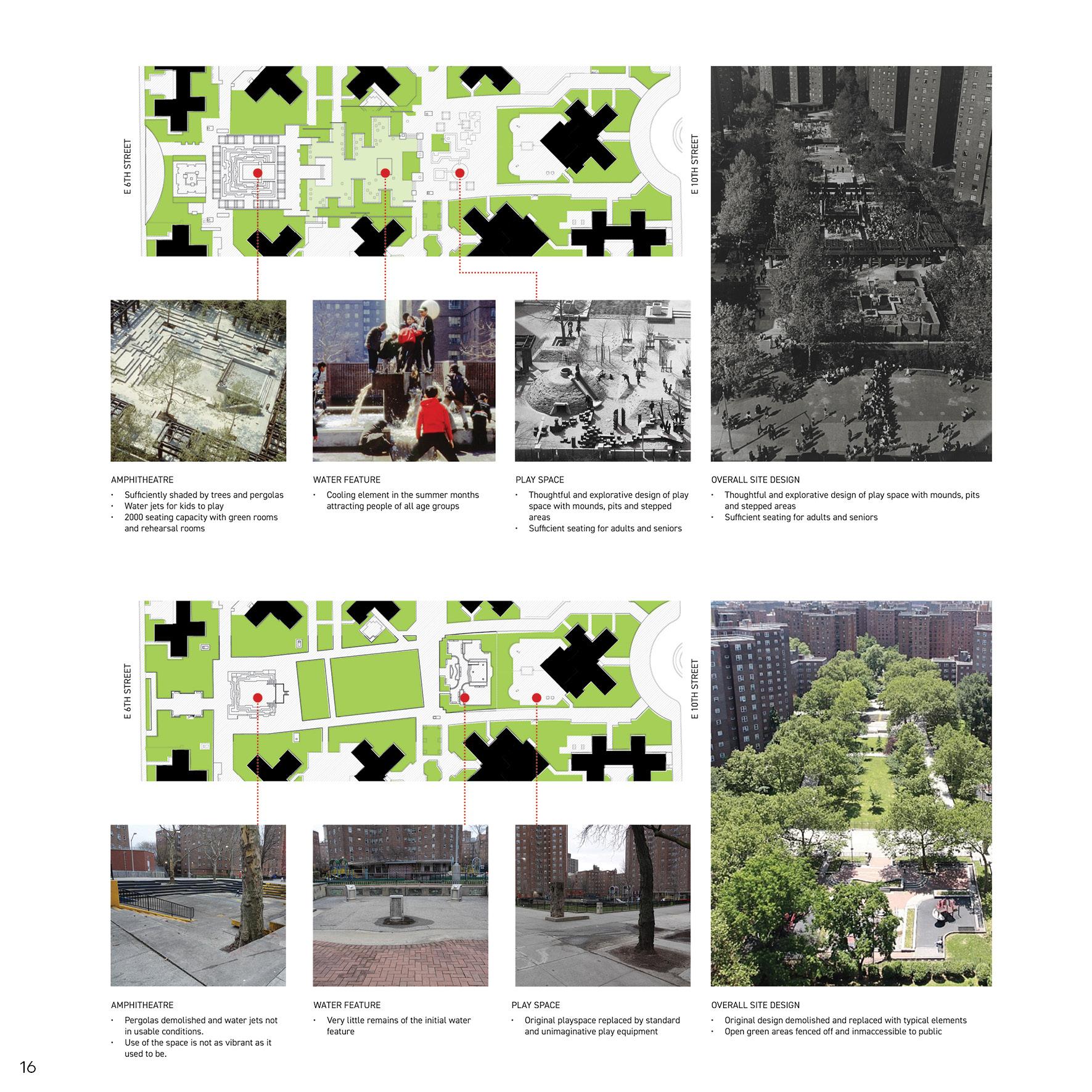
Previously designed by Friedberg as an interested sequence of programming the ground, overtime due to lack of maintenance and other issues, the original site has been transformed to less accessible and typical lawn infrastructure.
This project is an analysis and redesign of the NYCHA Riis housing open spaces. We analysed the site conditions, location, site composition, demographic composition, and the issues brought up by the residents.

neighborhood connectivity
demographics
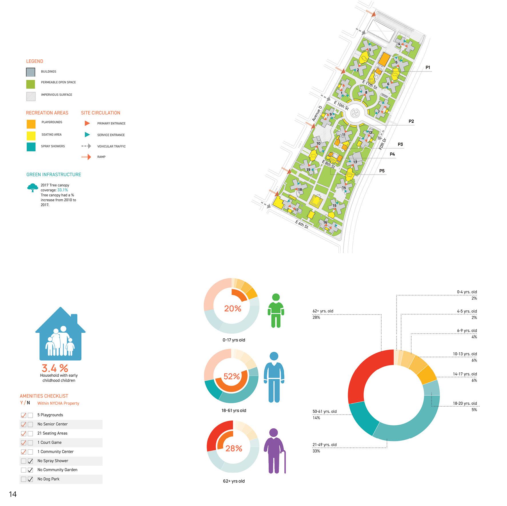
requirements

existing landscape

Type : Academic (MSUD)
Dates : Jan - May ‘24
Location : Austin
Instructor : Prof. Dean Almy
Team : Sri, DrishtiWW
Role : Mapping, framework concept, 3d modelling and illustrations
Honors : UTSOA
Design Excellence
2024 nominees
The project was a part of the Austin eastern archipelago studio where teams worked on different sites along the I-35 highway to accommodate future densities.
The Water Paradox identifies the flooding and drought extremities of the region because of soil tendencies and proposes water discharge, retention, detention and harvesting strategies as part of an ecological framework for controlled development.
It explores the various intersections of hydrology, soil percolation, transit and green corridors and presents them as opportunities for resilience and livelihood. The focus is on using the terrain to disperse and store water while determining development on areas of percolation and above all, connecting isolated neighborhoods through transit and landscape corridors. The site, sandwiched between important networks and natural sites stitches together commerce, ecology and community.

The flood - drought paradox is the result of flooding reducing the percolating capacity of the soil which in turn reduces the water holding tendency leading to high chances of drought.

flood and drought paradox

connecting the urban and the rural

strengthening the riparian edge
density along transit and landscape


Hindu temple
Austin Rodeo
Kipp School and Ancillary Programs
Natural Dams
Integrated Reservoirs
Camp Ground
Walk on Board
Camp fire
Cabins
Flower Viewing
Viewing Area
Fish Related Diving Area
Duck Viewing
Maps and Information
Exercise and Fitness
Playground Hiking
Archery Boating
Wood Gathering
COMMUNITY \ DENSITIES
Snack Bar
Restaurants
Grocery Store
Food Storage
Library
Lodging
Community Gardens
Bookstore / Souvenir Store
MOBILITY
Bike Rack
Proposed Bus Stops
Shuttle Service
Electric Charging Stations


Enriching the riparian corridor by integrating public spaces, landscape, storm water treatment park, bike and pedestrian trails and retail at intersections of transit nodes and water
Rejuvenating lake ecosystem by introducing floating wetlands that increase biodiversity and attract birds from the Hornsby Bend observatory. Activating the lakefront and introducing kayaking and fishing activities to boost tourism economy.
Transforming road bunds in the floodplains into elevated systems that allow for natural drain-off into retention ponds. Insertion of commercial units that enable a community space.

Type : Professional (architectureRED)
Dates : Aug ‘21Sep ‘22
Location : Bangalore
Team : Biju Kuriakose, Kishore Pannikar, Oveas Ahmed
Role : site and consultant coordination, site inspection, good-forconstruction drawings, 3d, design of ground, compound wall, security cabin, creative room and lobby spaces, detailing.
Assetz Sun & Sanctum is a 300 unit housing project in Bangalore. It is formalized with the concept of stepped terraces to create a strong and active skyline for the context. The ground is designed to respect the topography of the site, by separating the levels of vehicular and pedestrian access which in turn creates an opportunity to program the ground as different communal spaces. I was the project architect and responsible for holding
client and consultants coordination, site visits, team handling along with producing GFCs and design detailing. I contributed to the design of community spaces and the landscaping at the ground level. The project exposed me to the elaborate process of working large scale with an overwhelming team of experts in various facets, working with strategic coordination to make a project of this scale to take off.

1. raising the podium to accommodate parking

4. defining courts between blocks
2. defining the focus with clubhouse
3. extending the experience across site
5. creating connection between anchor and entrance
6. weaving private and social spaces


The ground level consists of a series of community spaces linked by a common corridor that connects all 5 wings creating a sequential experience. These spaces are anchored by the clubhouse.


Type : Professional (Grain Collective)
Dates : Jun - Aug ‘24
Location : New York
Supervisors : Sapna Advani, Ali Estefam
Role : community outreach; planning, graphics and preparation for tabling events, community workshops
The Organics project was a time-based community outreach program along with NYCHA and Compost Power to inform the communities about the DSNY Smart Bins and composting ideas. We held tabling events, compost workshops, and community gardening at 13 NYCHA developments and giveaways on Family Days.
The Nostrand Community Priority Survey was a part of the development
shift where the residents were surveyed on what they’re willing to change about their development. I was involved in creating graphics, surveying, preparing for and attending community meetings to inform volunteers about the resident survey process.
The summer internship at Grain Collective exposed me to the groundwork process of urban planning and design.

Type : Academic (MSUD sem 1)
Dates : Aug - Dec ‘23
Location : Austin
Instructor : Prof. Liang Wang
Team : Sri, Tess
Role : mapping, design framework, concept diagrams and visualization
Middle Grounds is a project that addresses the disparity in economic opportunities on either side of I-35 because of the historical redlining of East Austin. It also addresses the ‘missing middle’ typologies of 2-20 units in Austin, which is predominated by single family houses and highrise apartments, creating an uneven distribution of densities. The rising boom of tech industry and the need for open public recreational spaces plays an
important role in the development of this post-industrial site, which is situated near the East-side Bus Plaza, and edged by the Colorado River, with the East Chavez road cutting through.
Middle Grounds is a mixed-use neighborhood that enables the coexistence of tech companies and a mixed-income neighborhood through a well connected system of public nodes that reflect the cultural values of the neighborhood.

NETWORKS
Activity corridor
Highway
HOUSING
Predominantly Black / Hispanic
Predominantly White
Moderate proportion of missing middle
High proportion of missing middle
PLANNING - Imagine Austin
Neighborhood center
Job center
Industry
Tech
Regional center

vertical stacking of program connecting open spaces and waterfront retaining cultural structures integrating recreational spine and density


The larger courtyard typology in the main district is more public and faces the cultural spine. It has retail on 2nd floor that is connected from the other side of the road through the pedestrian bridge.


The mat typology creates a middle density that is on a smaller scale and inclusive of nature as it faces the river trails and is interwoven with mini-gardens.

The community market acts as an inviting entry space for the active pedestrian spine of the development. It encourages selfemployment and interacting opportunities for the different housing economies present.


The artist plaza is surrounded by warehouse structures that are creatively reused as gallery spaces and mural canvases. It provides a hangout space for the artist and other community that exists in the site. The site is characterized by these canopies on important cultural and social locations that indicate a significant social pause.

Type : Competition
Dates : Oct- Jan ‘23
Location : Seattle
Advisors:: Rebecca, Todd, James, Dean Almy
Team: Erin, Maria, Aishwarya, Robert, Sri
Role : mapping, concept, 3d modelling, postproduction, illustrations
Being at the historical core of Seattle, the Circuit celebrates the diversity of cultures and domains around it. The project creates opportunities for the tech, healthcare, artist and other communities and facilitates an environment where they can afford improved livability. The site is revived through housing for the working sectors and a place for collaborative learning and innovation. The Circuit transforms the region, from a “skid row” that divided the communities, into a crossover that brings people of diverse backgrounds together into a thriving neighborhood.
Being at the historical core of Seattle, the Circuit celebrates the diversity of cultures and domains around it. The project creates opportunities for the tech, healthcare, artist and other communities and facilitates an environment where they can afford improved livability. The site is revived through housing for the working sectors and a place for collaborative learning and innovation. The Circuit transforms the region, from a “skid row” that divided the communities, into a crossover that brings people of diverse backgrounds together into a thriving neighborhood.

low walkability and green infrastructure walkability and eco-sensitivity

potential to elevate cultural density
inacces of employment to low-income population
connecting existing cultural and historic threads
diversity of job opportunities


