Southern Peninsula
Celebrating 20 years in 2026
Genuine care when it matters most www.rosebudfunerals.com.au
Fighting for the community since 2006
123 Jetty Road, Rosebud
Ph: 5986 8491
An independent voice for the community
Your weekly community newspaper covering Safety Beach to Portsea
17
FREE
Wednesday 9 September 2026
For all advertising and editorial needs, call 03 5974 9000 or email: team@mpnews.com.au www.mpnews.com.au
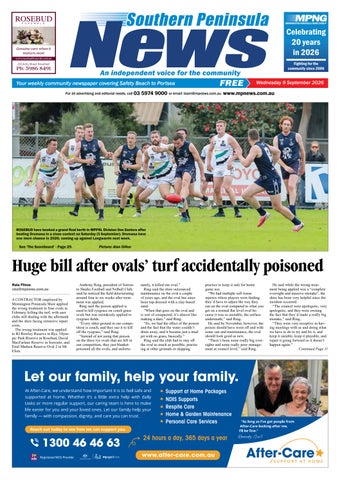
ROSEBUD have booked a grand final berth in MPFNL Division One Seniors after beating Dromana in a close contest on Saturday (5 September). Dromana have one more chance in 2026, coming up against Langwarrin next week. See ‘The Scoreboard’ - Page 29.
Picture: Alan Dillon
Huge bill after ovals’ turf accidentally poisoned Raia Flinos raia@mpnews.com.au A CONTRACTOR employed by Mornington Peninsula Shire applied the wrong treatment to four ovals in February, killing the turf, with user clubs still dealing with the aftermath and the shire facing extensive repair costs. The wrong treatment was applied to RJ Rowley Reserve in Rye, Olympic Park Reserve in Rosebud, David MacFarlane Reserve in Sorrento, and Emil Madsen Reserve Oval 2 in Mt Eliza.
Anthony Ring, president of Sorrento Sharks Football and Netball Club, said he noticed the field deteriorating around four to six weeks after treatment was applied. Ring said the poison applied is used to kill ryegrass on couch grass ovals but was mistakenly applied to ryegrass fields. “Every other ground in our competition is couch, and they use it to kill off the ryegrass,” said Ring. “Instead of not using that poison on the three rye ovals that are left in our competition, they just blanketpoisoned all the ovals, and unfortu-
nately, it killed our oval.” Ring said the shire outsourced maintenance on the oval a couple of years ago, and the oval has since been top-dressed with a clay-based sand. “When that goes on the oval and is sort of compacted, it’s almost like making a dam,” said Ring. “So, we had the effect of the poison and the fact that the water couldn’t drain away, and it became just a mud pit with no grass, basically.” Ring said the club had to stay off the oval as much as possible, practising at other grounds or skipping
practice to keep it safe for home game use. “We had multiple soft tissue injuries where players were finding they’d have to adjust the way they ran on the oval compared to what you get on a normal flat level oval because it was so unstable, the surface underneath,” said Ring. He said by November, however, the poison should have worn off and with some sun and maintenance, the oval should look good as new. “There’s been some really big oversights and some really poor management at council level,” said Ring.
He said while the wrong treatment being applied was a “complete oversight and massive mistake”, the shire has been very helpful since the incident occurred. “The council were apologetic, very apologetic, and they were owning the fact that they’d made a really big mistake,” said Ring. “They were very receptive in having meetings with us and doing what we have to do to try and fix it, and keep it useable, keep it playable, and repair it going forward so it doesn’t happen again.” Continued Page 11