Free!
Lake Geneva
A CSM Company
SERVING THE VILLAGE OF ANTIOCH AND TREVOR WEDNESDAY, JULY 19, 2017 DISPLAY ADS (262) 877-2813
VOLUME 06 • NUMBER 9
CLASSIFIEDS (262) 728-3411
DELIVERY (262) 728-3411
147 E. Main Street, Twin Lakes, WI 53185 • Published By Southern Lakes Newspapers, LLC
Under new Own
ership
Enjoy $10 OFF
Any Part or Ser vice 262.249.5252 • la of $50 or More! kegenevagm.co Limited one coupon per customer. By app m ointment only. Cou purchase. Managem pon must be ent reserves all righ
Record flooding puts two states at standstill
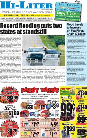
When heavy rains fell on Northern Illinois and Southern Wisconsin last week, it left several municipalities scrambling to address flooding concerns along the Fox River, where record flooding occurred. The rainfall caused the City of Burlington to shut down four bridges surrounding the Fox River, where floodwaters damaged area homes and businesses, according to the Burlington Standard-Press. Meanwhile, down the Fox River flow, the National Weather Service recorded a record flood stage of 17.5 feet, supplanting the previous high set in 2008, when it was 15.43 feet. With record setting readings, it caused excess water to flow downstream into Fox Lake and Chain O’Lakes, according to the Illinois Department of Natural Resources. “The Fox River near New Munster is forecasted to continue to fall, but it will be over one week before it falls below flood stage,” the DNR states. “This flow is higher than we have seen on the Chain.” The flow resulted in state officials opening the gates at the Stratton and Algonquin dams, according to the state DNR, which said the Fox Lake flood stage is 7.9 feet and forecasted to crest on Monday. Meanwhile, in Burlington, where the city had a curfew for three nights, opened the Echo Lake dam to ease pressure and prevent further erosion along shorelines. The opening of Echo Lake’s dam has been a concern, noting it could exacerbate conditions downstream, but the DNR reports the dam has held up. “The dam in Burlington has not breached,” the DNR states. As Illinois officials work to address flood-
EARLENE FREDERICK Hi-Liter
A resident escapes from her vehicle, which had two of her children inside, and is rescued by Salem Lakes fire officials during last week’s flooding.
ing concerns, Village of Fox Lake Mayor Donny Schmit issued a statement on social media, where he explained the flooding situation. “The Chain is like a big bath tub. If the bath tub can drain 10 gallons a minute (Stratton dam) and you’re putting 20 gallons (Fox River from New Munster) a minute into it, the level in the tub will rise and go over the sides. This is what has been occurring in the
presented at booking ust 31, 2017.
ts. Valid through Aug
Chain,” Schmit wrote. “When IDNR says the flow rates are decreasing, they are, but in the bath tub example, they have gone from 20 gallons a minute down to 15 gallons per minute. The Chain is still rising, but not as fast.” “When the Chain crests today, again using the bath tub example, it means that 10 gallons is coming in and 10 gallons is going out. This should occur today.”
288649
~ formerly Antioch Report
Flood Levels to Increase on Fox River/ Chain O’Lakes
According to Lake County Emergency Management officials, they expect to see flood levels on the Fox River and Chain O’Lakes area to increase, a release states. Significant flooding continues in Lake County from the Chain O’Lakes, Fox River and Des Plaines River,” the release states. “Even though the weather forecast looks promising over the next couple of days, we are still monitoring flooding of several rivers, streams and lakes.” The release also issued the following reports at each of the rivers: Fox River/Chain O’Lakes The Fox River gauge at New Munster, WI has crested at 17.5 feet and is going down. This is about three feet higher than the 2013 crest level. Those who live along or near the Fox River and Chain O’Lakes should continue to prepare for high water over the next several days. Fox Lake at Lake Villa is currently predicted to crest sometime between July 17-19. There is high concern for road and structural flooding. Sandbagging efforts will continue. The Lake County Stormwater Management Commission has created inundation maps for the Chain O’Lakes, which show a prediction of additional structures that will be impacted. Des Plaines River The Des Plaines River at Russell, Gurnee and Lincolnshire are at major flood stage. The river at Russell has crested, and at Gurnee it’s expected to crest tomorrow. At Lincolnshire, the first crest was at 16.5 feet and has been falling since. However, the current forecast indicates water levels to increase again today and have a second crest of 17 feet Saturday afternoon before decreasing.
288568