


I was born in Nieuwegein in The Netherlands and moved with my family to Florence, Rome, and London before we settled down for good in Cincinnati, Ohio. My family and I traveled back home frequently- mixing in our trips to the Netherlands with visits to France, Switzerland, Mexico, Gautemala, and other countries.
My education is in City and Regional Planning and Development Management, which has allowed me to see the world from both an analytical and design perspective. Since then, I have worked in a variety of organizations in research, program management, and communications roles. A year and half ago, I started a three year Master’s program in Landscape Architecture at Temple University, in Philadelphia. In November, my husband got a wonderful work opportunity in Rotterdam- since I had always wanted to move back to The Netherlands, we took this opportunity, even though it unfortunately meant ending my Landscape Architecture Master’s without finishing.
My first role was as a program officer in the microfinance sphere in Philadelphia at The Women’s Opportunities Resource Center. I worked to manage the lending portfolio and the entrepreneurship training program. I helped build an evaluation function at WORC and managed our outward communications with monthly newsletters, data dashboards, and online curriculum design.
In 2019, I helped found a nonprofit, Small Things, which has grown from providing 10,000 meals annually in 2017 to providing over 9 million meals in 2021. I managed all communications, including developing a new brand and brand guidelines, building a new website, and designing and writing

copy for our annual reports and newsletters.
Moving forward, I would like to combine my passion for Urban Planning and Design with Landscape Architecture. I am passionate about creating new spaces for (and with) people and nature. I am excited about the new opportunities to design, learn, and share knowledge as I transition to working in the Netherlands.
Education
London School of Economics; London, UK
Master of Science Development Management
The Ohio State University; Columbus, OH
Bachelor of Science City and Regional Planning
Summa Cum Laude; American Planning Association Distinguished Student Award; Faculty Award
Director of Communications | Small Things; Philadelphia, PA
01/2018 - Present
• Manage communications with stakeholders, partners, and volunteers to increase food distribution to families in need from 10,000 meals annually to 2.5 million meals in 2020.
• Create and implement charitable giving goals and fundraising campaigns and manage fundraising platforms to triple fundraising from $100,000 to $300,000 in 2020.
• Author, edit, and format communications including the website and annual reports.
• Develop and promote our brand, images, and identity to the media and public during the growth from a seasonal project to a year-round non-profit organization.
Project Manager
• Managed stakeholder relations with 70 community organizations and funders to raise over $100,000 annually and spread awareness about food insecurity in Philadelphia.
• Prepared and manage annual program budgets for advertising and project support.
Program Manager | WORC; Philadelphia, PA
05/2018 - 08/2020
• Helped manage a $1.5 million loan portfolio and support struggling clients with technical assistance and capacity building through workshops and one-on-one assistance.
• Managed digital communications including the development of monthly newsletter, writing copy for grants and annual reports, and developing graphics for programs.
• Built and pilot tested an online entrepreneurship training curriculum to provide flexible learning options for clients with challenging schedules and alternative learning preferences.
• Adobe InDesign
• Adobe Photoshop
• Adobe Illustrator
• Sketchup
• AutoCAD
• ArcGIS
• Tableau & PowerBI
• English (fluent)
• Dutch (proficient)
• Spanish (intermediate)
This studio class we followed a specific process to lead towards a finalized bathhouse in a landscape. The process included:
• Modeling and dividing a cube
• Drawing the model
• Reframing the landscape
• Designing the final landscape
In this project we were required to make a model of a cube out of basswood and use shapes (squares, rectangles, Ts, Ls, and donuts) to split the model into different compartments.
This is an image of the 12”x12” cube built out of 1/4”x1/4”x12” basswood sticks. The model was split into halves and then into thirds. Later cardboard shapes were added to see how light travels through the model in different ways.
After splitting the original modeled cube into various shapes the objects were drawn from multiple angles to demonstrate how they fit together to create the original cube.
The resulting product was then projected onto vellum and redeveloped into a landscape drawing.
A section of the drawn cube was used to develop a stamp. This stamp was used to develop the lines which created the landscape on the right. The landscape was inspired by the Italian garden, with a focus on grandeur, elevation changes, the travel of water through the landscape, and creating small hidden caves in the landscape.


A small part of the site plan was chosen as the final site plan for the bathhouse model. The numbers represent different elevations and the colors represent different materials.
A small cutout of the landscape below formed the base for the plan for the final bathhouse and landscape (right).


The final stage of the Studio project was to use the plans and sections to develop a 3-D model of a bath house in the landscape. The objective was to create the impression of a bathhouse with two separate pools that was integrated into its surroundings, while also appearing to float above the landscape. A secondary goal was to create a bath house that provided clear public and private spaces.
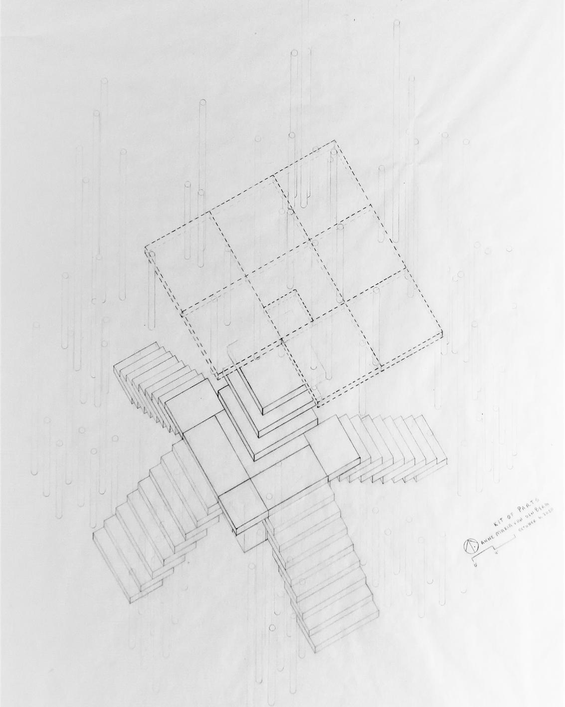
This project is an investigation in mass, space, and light. In its essence, this project takes advantage of the different spaces and voids created through a particular palette of shapes. Built on a 24” x 24” grid, this project is built from white mat board and wood dowels on a foam core board. The project is designed entirely by using only 6 parts:
• 3” x 3” x .25” panels
• 3” x 1.5” x .25” panels
• 2” x 1.5” panels
• 1.5” x 1.5” panels
• 1.5” x 1.5” cubes, and
• .25” dia x 3” round columns.
My purpose for this project was to use the parts to create 2 types of gathering spaces that play into the concept of public vs private space and to explore the role of light in creating these different spaces. The design uses prospect and refuge to create these separate spaces. One space will be up on the platforms at the terminus of the ‘staircase’ and the other will be below the platform.
On top of the platform is an open and public space that is exposed to the elements. Once on the final platform, the individual is treated to an expansive view of the surrounding landscape.
The second space, under the platform, is private and more intimate. The space is sheltered from the elements and is smaller. Instead of an expansive view of the landscape, you are on the lower level, and focus just on the immediate environment around you. The tree coverage in this area is significantly denser to emphasize the feeling of enclosure.


In this design, similar to the Spanish Steps in Rome, or the Art Museum Steps in Philadelphia, the steps function as both a space of movement and gathering.
Both the upper plaza and the lower plazas are spaces of rest.
The form and movement of the design encourage individuals to explore both the upper and lower elements as they circulate through the separate spaces.


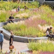
The purpose of this project was to design a Library Plaza for the Ambler Campus that would offer a pleasant place for students, faculty, and visitors to sit, eat, and socialize; enhance the existing circulation patterns; and educates the public about best management practices and natural landscapes.
This design anchors the northeast side of campus by creating two new major spaces. The first space, in front of the library, uses large raised planting beds with incorporated seating to create a more quiet, contemplative space. The planting beds are laid out to leave a larger path between Bright Hall and the Learning Center. The tall meadow and wildflower planting here will connect to the meadow in the rear of the library and soften the facade of the library. Additional modifications include: the development of a larger entry path to welcome visitors to the site and modifying the directions of existing paths to create an elbow with a statue of Jane Bowne Haines to celebrate the Ambler Campus history as the Pennsylvania Horticultural School for Women.
The focus of this redesign is the rear of the library. Currently there is a steep drop-off from the library to a large lawn area with little visual interest besides a small wetland area towards the parking lot. This design proposes a large two-tiered deck which looks over a pond. The pond curves to create continually fresh views of the space. The pond is surrounded by large wetland and upland meadow plantings reminiscent of Piet Oudolf’s work to create year-round visual interest. The deck itself provides both cafe style seating and bar style seating to provide multiple ways to gather, eat lunch, or read a book.


Anchor the northeast side of campus in an engaging landscape.
Create unique spaces by the library that provide the opportunity for both quiet activities like reading as well as a space for gathering together to enjoy lunch, work on a group project or host a happy hour.

Design a landscape that will provide both aesthetic and educational value.


Improve the entryway into campus.
Connect pathways in front of Learning Center to paths leading to the Library, West Hall, and Bright Hall.


An axonometric drawing of the proposed Ambler Library Redesign


A section drawing of the design


This project focuses on the revitalization of a small borough just north of Philadelphia- Jenkintown. This historic borough 248 acres and has a population on 4,500. As part of the studio, we took a thorough inventory of the towns strengths, opportunities, and weaknesses.
The Wayfinding, Branding, and Signage group looked specifically at ways to build on the historic brand and identity of the town.
The opportunities and constraints demonstrated the need for a Design and Branding Package which built on the borough’s history but also gave it a modern feeling.
The last component of the project focused on a detailed design of one specific area of the borough. The detail design, Gateway Park, is located on the north edge of the Strawbridge & Clothier Building, along Old York Road and near Noble Station at the North gateway into Jenkintown. It is a 1.43-acre site that is currently used as a parking lot. The site abuts Old York Road on the West side and a large parking structure on the South edge.
The Jenkintown Comprehensive Plan, as well as the inventory and analysis provide multiple recommendations which can be applied in the design of this site, in particular:
• Providing more park/ green space for the residents of Jenkintown.
• Improving the pedestrian experience/ pedestrian safety.
• Providing additional spaces for children/ teens to play or hang out.
• Building a unique brand/ identity for Jenkintown.
• Creating gateway spaces that welcome individuals into Jenkintown.
• Reducing stormwater run-off and increasing the pervious surface coverage in the borough.

School Zone is an opportunity to create school specific branding Connect routes to station with Town Center through consistent furnishings + amenities
West Gateway with iconic Jenkintown sign.
Major intersections creates opportunity for improved wayfinding.
Wayfinding, Branding, and Signage Opportunities and Constraints
North Gateway with historic Strawbridge Building


Town Center along York Road with historic Hiway Theater


York Road entry points to Town Center, school, and train station Linear connection between South and North Gateways


• Develop a cohesive and engaging borough identity that builds on the historic identity of Jenkintown as well as its school spirit.
• Develop a cohesive and engaging borough identity that builds on the historic identity of Jenkintown as well as its school spirit.
• Increase and Expand flexible public space. Brand sidewalks as a public space with cohesive public amenities, lights, and signage.
• Increase and Expand flexible public space. Brand sidewalks as a public space with cohesive public amenities, lights, and signage.
Modify the gateways so there is a clear transition into Jenkintown.
• Modify the gateways so there is a clear transition into Jenkintown.
• Highlight the Business District and School Zone as special areas.
Highlight the Business District and School Zone as special areas. Improve wayfinding through consistent signage and visual cues.
• Improve wayfinding through consistent signage and visual cues.
Connect the Boroughs green spaces.
• Connect the Boroughs green spaces.


Create an exciting and inviting gateway into Jenkintown that welcomes people coming both by car and from Noble Station.

Provide multiple different spaces where residents and visitors can come to relax, spend time with friends, and enjoy nature.

Build accessible spaces for both active and passive play for children in multiple age ranges. Provide both engaging built and natural features.
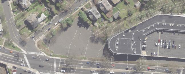

The current sidewalk is right next to the high speed traffic on York Road, which creates an uncomfortable pedestrian experience.
The current view as you enter the north end of Jenkintown from York Road or coming up from Noble Station is a large parking lot with a large parking structure in the background. Transforming this space into a park creates a way to welcome residents and visitors to Jenkintown.


The design of the gateway park uses bold elements like a large entry plaza with a water feature to make a statement for those entering Jenkintown and to highlight the park as an entrance into the borough. The open lawn provides space for passive and active recreation. The meadow functions to soften the views, manage stormwater runoff, and provide respite from the excitement of Old York Road.
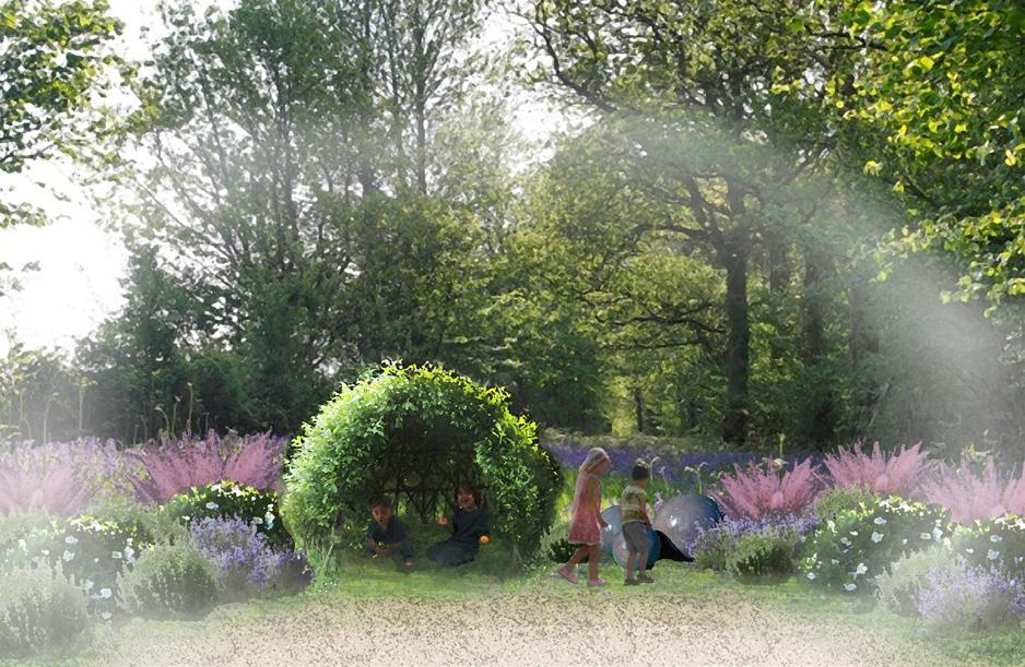
The playground area is designed to engage children in multiple age ranges, provide spaces for learning and exploration. The sensory garden will allow children to engage with a variety of smells, textures and sounds to create a passive educational experience.


This project walked through the rendering process, starting out with using a set of instructions and dimensions to create an AutoCAD file. Based off of the AutoCAD document, I designed a basic SketchUp rendering of the project. The project was them finalized in Photoshop.


The request for this poster was to design a comprehensive poster covering the ecological restoration of High School Park, a restoration project in Elkins Park, PA. This poster covers everything from the history of the site to the restoration components used along each part of the park transect. The poster highlights different plant and animal life as well as some of the challenges that came along with the restoration project.
Location: Montgomery Ave & High School Rd- Elkins Park, PA 19027
Geology: Wissahickon Formation- Oligoclase mica schist
Soils: Urban Land -Udorthents, schist and gneiss complex (Uug
History:
Previous site of the Cheltenham High School Complex.
Friends of High School Park worked with Cheltenham Township, the PA DCNR to acquire the property and Andropogon Associates to design a Masterplan for the park.
In 2011, Wells Appel planned a redesign of the natives meadow and welcome garden, new educational signage, seating areas and pathways.
• The park has an Ecological Restoration manager who supports ongoing restoration efforts.
Friends of High School Park (FHSP):
to support the park, and
of volunteer
the


Methods:
Ecological Restoration:
Restore native meadow, edge, woods, and shoreline species
Remove invasive species
Develop a 10-year restoration management plan was developed to ensure management of invasives.
Recreation & Landscape Features:
Maintain historic built features such as the old school wall and stairs.
Address runoff from the meadow through upper and lower rain gardens.
Improve wayfinding signage, lighting and seating options. This includes the installation of a meadow walkway and new educational signage.
Streambank Stabilization:
Provide stabilization, restoration, and riparian buffer for Tookany Creek
Cribface Walls and shoreline planting were used to stabilize the creek and manage high stormwater flows.
1. The meadow was built on urban land that had structures- so it was challenging to create a good soil layer to establish the meadow.
2. Invasive plant management is an ongoing issue that requires continual work.
3. Budget/ timing issues to maintain the trails and ecological areas properly.
Creek Edge & Lower Rain Garden
dogwood (Cornus sericea)
(Sambucus canadensis)
Arrowwood viburnum (Viburnum dentatum)
willow (Salix nigra)
(Platanus occidentalis)
(Acer rubrum)
knotweed (Reynoutria japonica)

Ostrich fern (Matteuccia struthiopteris)
Canada goldenrod (Solidago canadensis)
Orchard grass (Dactylis glomerata)
Mock strawberry (Potentilla indica)
False nettle (Boehmeria cylindrica)
*Mugwort (Artemisia vulgaris)
The
Song Sparrow Ruby-Throated Hummingbirds
Common milkweed (Asclepias syriaca)
Yellow sweet clover (Melilotus officinalis)
Wild bergamot (Monarda fistulosa)
Foxglove beardtongue (Penstemon digitalis)
Bottlebrush buckeye (Aesculus parviflora)
*Mugwort (Artemisia vulgaris)
Oxeye daisy (Leucanthemum vulgare)
Canada goldenrod (Solidago canadensis)
Yellow sweet clover (Melilotus officinalis)
Common burdock(Arctium minus)
*Crown vetch (Securigera varia)
*Mugwort (Artemisia vulgaris)
Ostrich fern (Matteuccia struthiopteris)
Black chokeberry (Aronia melanocarpa)
Eastern redbud (Cercis canadensis)
Pawpaw (Asimina triloba)
Inkberry (Ilex glabra)
Tuliptree (Liriodendron tulipifera)
Black walnut (Juglans nigra)
American elm (Ulmus americana)
*Ground elder (Aegopodium podagraria)
*Amur honeysuckle (Lonicera maackii)
*English ivy (Hedera helix)
*Wineberry (Rubrus phoenicolasius)


American
Sweetbay
Cucumbertree
Witch
Serviceberry
American


Andorra Natural Area is the northwestern gateway into Wissahickon Valley Park. Located on Northwestern Avenue, the 86-acre park provides access to over 3 miles of local hiking trails through meadows , forest, and along the Wissahickon Creek. The park is frequently used by residents of Philadelphia and Montgomery Counties.

The purpose of this studio project was to reimagine what Andorra Natural Area could look like while integrating human and animal activities within the landscape.

While the site does not need to attract any more visitors, stakeholders were looking to balance the interactions between humans and nature on the site. The park currently has several issues, including, but not limited to:
• Excessive deer population that stifles the growth of native plants.
• Erosion of steep paths from intense rain events.
• Conflicts between users: pedestrians, bikers, and equestrians.

• Poor wayfinding and signage make the trails challenging to navigate.
• Lack of access to public restrooms.
This project is called “Building Thriving Habitats” as it seeks to develop Andorra into a park that supports both the humans that visit and the plant and animal life that live there. This project included an inventory and analysis of the slopes and hydrology of the site. the development of an overall concept, a masterplan, a detail design for a small area, and a restoration project that corresponds with the detail design area


Wissahickon Creek Watershed is 23,270 acres and runs through Montgomery and Philadelphia County. The Wissahickon Creek meets the Schuylkill River in Philadelphia, which eventually joins Delaware River and flows into the Delaware Bay.

Surface Coverage in RF3 mini-shed


Andorra Meadows Pervious Area Contribution

Pervious Area
Andorra Pervious Area


The Wissahickon Creek Watershed has a mixture of surface covers. Less pervious cover types (in gray) make up 50% of the watershed. Lowhigh intensity development can increase the IC for surface runoff 250 - 700% (NOAA). Higher runoff can lead to decreased water quality, increased amounts of sediment in the water, and erosion of the creek.
In this concept design, habitat and accessibility were addressed head on. This concept proposed a new ADA friendly parking lot that connected to an accessible boardwalk which runs through the forest as well as the meadow(4). The meadow was expanded to include a large wetland area with a bridge (7). A tall planted edge would surround the northwest and western sides of the
park to block new developments. The educational and interactive forest would engage children and adults through education, nature play, and programmed events. Lastly, this concept takes advantage of the steep slopes along the northeastern edge of the park to create a canopy walk that meets the path at-grade on both ends, making it fully ADA accessible.


Using ideas from the concept design and critique, I developed a masterplan for the area to meet four primary goals:
1. Preserving and enhancing the existing natural elements in the park
2. Enhancing the passive educational opportunities available to visitors
3. Improving accessibility throughout the park, and
4. Targeting restoration efforts in the park.
This plan includes three primary character districts: an Education and Integration District that takes advantage of the existing Cedar’s House and WEC, a Habitat Creation District which expands and enhances the existing meadow area, and the Habitat Restoration and Exploration District which serves as a space for hiking, relaxing, and woodland restoration. Together these interventions can preserve the natural areas of Andorra, while making it an exciting place for people to visit.
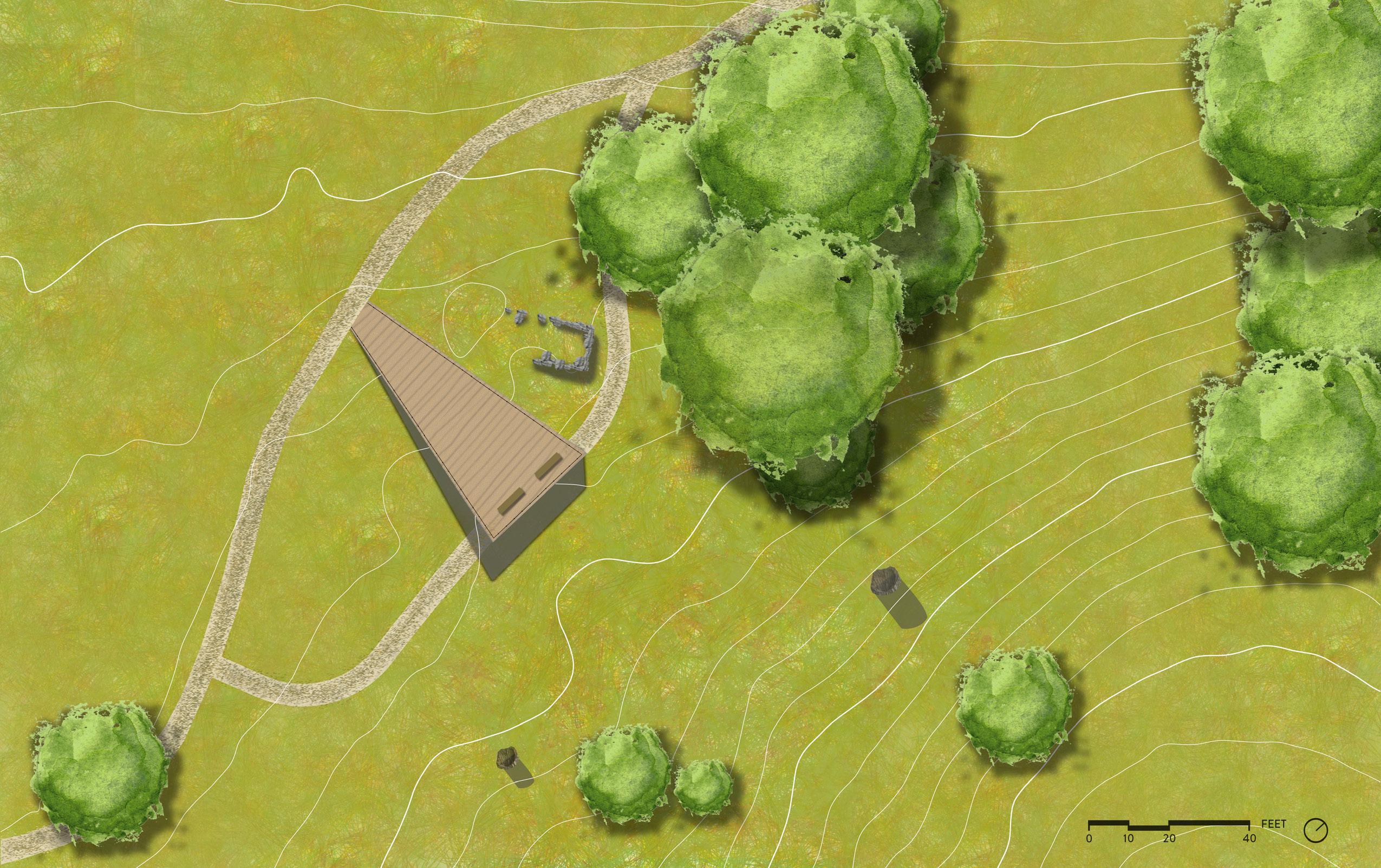
Existing Ruins
Existing Path
Proposed Platform
Proposed Bird Blind Path
Snags from dead trees


The detail design for this project focuses on the meadow area. The design consists of a upper walkway and viewing area where visitors can see across the lower meadow from above, as well as a lower bird blind which will allow visitors to engage in birdwatching activities. The addition of new trees and shrubs as well as more snags and pollinator-friendly meadow planting will attract increased wildlife to this area for people to enjoy. The new path winds by the Black Farm Ruins allowing visitors to engage with and learn from this piece of Andorra history.

Upper meadow life viewing platform
Lower Path
The section through the Meadow Life Platform shows the two separate spaces created by this design. The upper platform acts as a gathering space where individuals can rest and passively enjoy their surroundings. Visitors have views of the meadow, the woods beyond, as well as the ruins to their left. The lower area provides a secluded area where individuals can bird watch without disturbing the animal life around them. The Schist wall connects this new design with the existing ruins that sit along this lower path.
