ÅKERMANS EXCURSIONS
Learnmoreduringyourvisit or travel

Learnmoreduringyourvisit or travel
Learnmoreduring your visitortravel.
by H. JonasÅkerman
Kullabacken ESEC HB
TheSouthernPart
ÅKERMANEXCURSIONS
Learnmoreduringyourvisit or travel.
ISBN: 978-91-8114-381-2
Issue1/1
©2026 Kullabacken ESEC HB Books kullabacken@telia.com
PostalAddress.
KULLABACKENc/o
Prof. H. JonasÅkerman
Smålandsvägen 20 22270 LUND SWEDEN
©2026 H.JonasÅkerman
Förlag:BoD ·Books on Demand, Östermalmstorg 1, 114 42 Stockholm, Sverige, bod@bod.se
Tryck: LibriPlureos GmbH,Friedensallee273, 22763 Hamburg, Tyskland
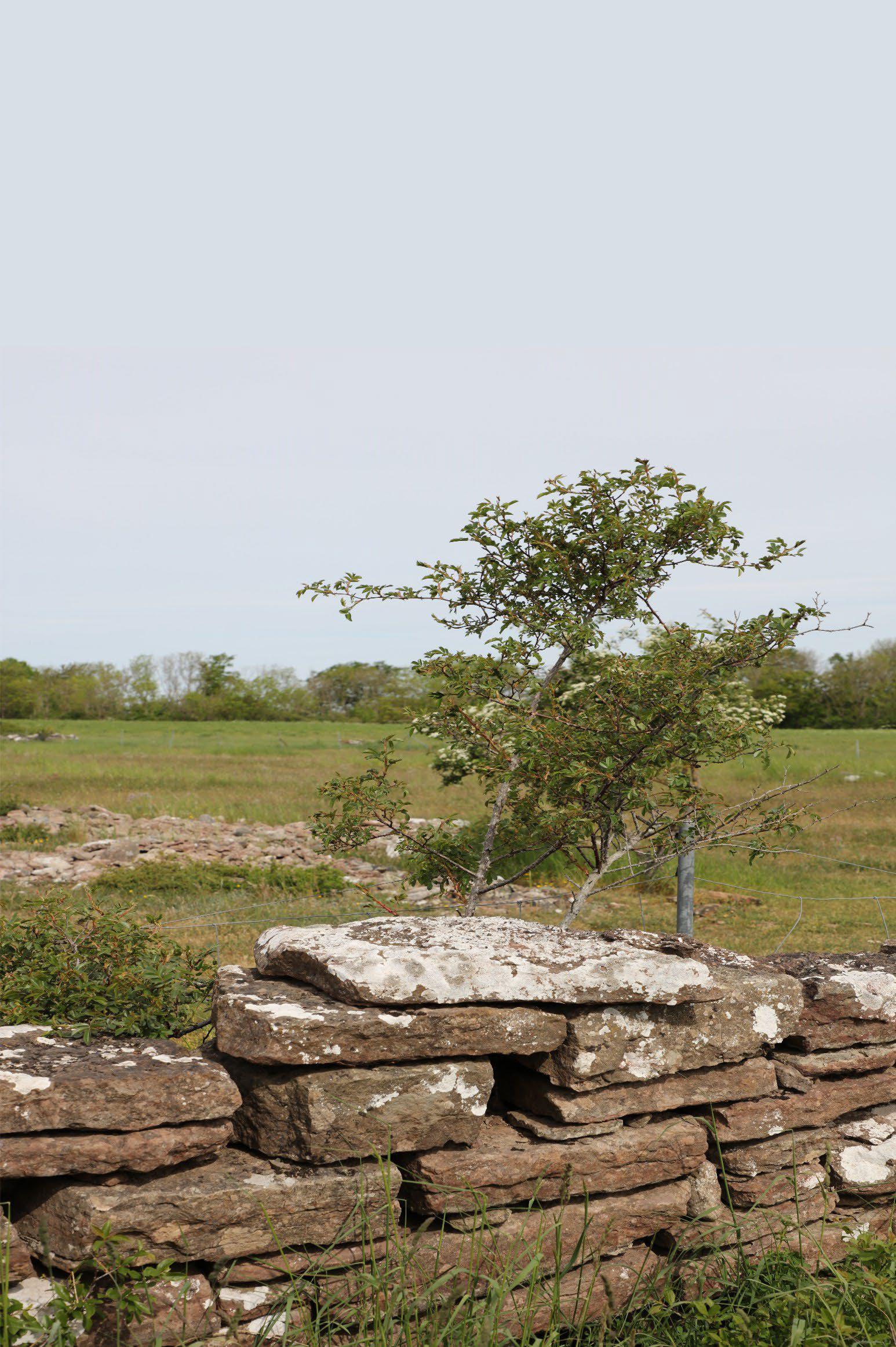
Coverphoto: Atypical stonefence at theÖlandsAlvar. (PhotoJ Åkerman)
Thefollowing summaryabout Öland wasoriginallycreated forthe Lund University course NGEA04“Ecosystemanalysis”—a fieldcourseweek held on ÖlandeachyearinMay from 2004 to 2025.A guidehas been developedfor studentstoprovide an introduction and overviewofÖland's physical geography, features,and generalphysiographicand ecological traits.The studentsare an internationalgroup, many of whom have nevervisited Sweden or even Europe.Thismaterialhas nowbeendevelopedinthisbook to also serveasa guidefor ageneral visitorto Öland.
Primarily,itoffersa generalintroduction to theisland'sunique environmentaland geomorphologicalfeatures. Theproposed excursion with itslistofstops canalsoserve as a startingpoint andresourcefor anyone visitingÖland forvarious reasons.Itisespecially designed forvisitors seekinga broaderand deeper understanding of theisland. Thematerial isn'tsolelyacademicbut mayappeal to anyone interested in nature whowants to learnmore before or during avisit to Öland. It canalsoencourage furtherresearch andreading.
Thefirst part discussesthe abioticcomponents, such as geology, soils, organicsoils, hydrography,geomorphology, andlandscape developmentsince thelastglacial period, along with theircurrent signs andfeatures. In thesecond part,which details theexcursion sites, we explainhow to interpretthe landscapeand itsfeaturesbyobserving everything from geology andsoils to land use, history, human activity, flora, birds, andinsects.
Allspecies describedand exemplifiedare providedwith theirEnglish, Latin,and Swedish names, likeinthisexample:The Mountain-avens(Dryasoctopetala,L.) (se. Fjällsippa). This mayseem tooformal, but it is done to help thereader search in otherliterature or media.
Much of thehistorical material comesfromthe publications of theSwedish Geological Survey (SGU)and theSwedish Geological AssociationinStockholm(GFF).The more recent material is partly drawnfromthe book “Natur ochKulturpåÖland” (Forslund, 2001) and from variousresources published by theregionalauthority,“Länsstyrelseni Kalmar län”. Thereare many additionalreferenceslisted that maysuityourinterests andneeds.
Lund January 2026
H. JonasÅkerman
Theislands Ölandand Gotlandare two naturalgeographicregions with unique and extraordinarycharacteristics. In the “official” natural geographic regional classificationofthe Nordic region, Öland andGotland representexoticareas with, compared with otherareas of theNordic countries, an anomalousclimate, hydrography, geology, fauna,and flora.
Ölandand Gotland belong geologicallyto EasternEurope,and much of thefauna and florahavea distinctly Easterncharacter. Most species have also invadedthe islands from theeastratherthanfromthe southand southwest, whichisotherwise themost common pattern in theNordicregion.
TheBaltic Shield,with its platform rocksof gneissand granite,extends to its easternmost pointonthe Kalmarslätten plain, whereitiscapped by underCambrian sandstone.The shield then continuesina “bowl” shapebeneath Öland, Gotland,and theBaltic Sea, re-emerging in Estonia. TheCambriansandstone at the bottomofthisbowlwas depositedabout 560 millionyears ago. It is ahardgray quartzite sandstone,often containing traces of dig-outholes from asea bottomsanddwellingwormcalled“Scolithus linearis” (Haldeman).Because of this,itiseasyto identify,and therock can be used asa tracingblock.(Remember thesimilar sandstone seen in Skåneduringthe excursiontoKullaberg.) Eventually,the
sandstone transforms into agrayshale,a blackalum shale, whichforms various sedimentarydeposits duringthe Ordovician period.
On to topofthisunbrokengeological sequence we find theclassic Ölands stone of Silurian age(starting440 millionyears ago),calledthe “Ortocer”limestone which covers themoresignificant part of Ölands surface area, andwhich can be of different colour (Maroon/grey)depending on the sedimentologicalenvironment(oxygenrich –gives areddish stone or oxygenpoorgivesa greyishorbluishstone). The limestonesare dividedintosuccessions depending on thefossilcontentofthe trilobite genus“Asaphus”(Brong.).
Seealsobelow underthe sectiongeology.
Climatologically,Öland is alocalclimatological dryareawitha comparativelylarge number of sunhours. Themainreasonsbehindthisare.
1. Theföhneffects observedonthe leeside of thelandscapetothe west –the South SwedishHighlands.Despite thehighlands' moderate elevations (<300m.a.s.l.),the influenceisclear andeasily seen in the region'stemperature andprecipitation patterns.
2. Theislands'temperature climatealsohas an evidentmaritimecharacter.
3. Awell-developedland-seabreeze circulationsystemprimarily characterizes thesummerclimate.
Hydrographically,Öland is characterized by alack of surface water. No traditional,
permanentfluvial surface-waterdrainage pattern is visible. However, thereisstill a fluvial surface-waterdrainagepattern with severalcatchment areas(SeeFig. 1.5). What canbeobservedinthefield andinthis figureisa pattern heavilyinfluencedby bedrockcrack tectonics.
Theabsence of faintand smallstreams, or theirscarcity,depends on thelimestone bedrockand its crackpattern andkarst drainage.However,the karstdrainagehas limitedmorphological significance because thelandscapeistoo flat andtoo young to have developedclear,typical forms. This appliestobothÖland andGotland. Subsurface drainage remainsimportant and can be observed in thefield,especially in some springs andseepage outlets. Themost productivesprings or subsurface drainage channels areusedfor village drinking water suppliesbut aremostlycoveredand hard to trace today.
Especially during winter,surface water channels oftenflowheavily as subsurface systemsbecome saturated. Dependingon thetimeofyourvisit,you mayobserve examples of this,either high-floworlowflow.
Thelimestone bedrock, clearlyillustrated in thenearly horizontalsedimentary packages andthe “Questa” that is calledthe “VästraLandborgen”, dominates the landscapeofÖland (Fig.1.1,cf also fig. 1.13). This geological form completely dominates thelandscapeofÖland, which we will seeduringour stay there.
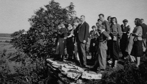
Figure 1.1LundUniversityProfessor HelgeNelson, with students, demonstratingthe westernQuesta landform(Landborgen)onthe island of Ölandin1942. (Photo by SonjaNilsson-42 Kindly submittedbythe family of Prof.Lennart Olsson)
1.2Small-scale Morphology
Regardingsmall-scaleforms,it'seasyto overlookthese landscapefeatures, but there is stillmuchtoobserve forthe curious visitor. Afterall, Ölandoffersa lotwhen you learnhow to spot variouslandform processes' shapes andmarkings.Mostof theseforms arerelated to weathering-both chemical andphysical-orare primarily connected to thelastdeglaciationand its differentstages. Asignificantpartofthis includesthe changing sealevelsofthe Baltic Seaduringdeglaciation. As shownin fig. 11.2,Öland wasinthe earlystagesof theBaltic IceLake, completely submerged beneaththe seaorlakesurface. Only a smallislandremainedabove sea/lake level at theend of thefirst stage– we will visit thesite.The deglaciationoccurred relativelyquickly oncethe inland ice retreated from Ölanddue to intenseice calving between Ölandand themainlandto thewest.
Glacial striations,which indicate the directionofinlandice retreat,are exceedinglyrare, especially in thenorthern part of theisland. What canbeobservedis afaint pattern running in aNW-SE direction. In thesouthern part of Öland, the icemoved more in an N-Sdirection, and thereismuchmoreobservational material, more evenly distributed.Manyerratic trace-block findings confirmthese directions of icemovement. Examples of differenterratic blocks includeSmålands porphyry,Småland Rapakivi Granites, BalticSea quartz porphyrite,granite from theÅland Islands, Dalaporphyrites,and others,which arefrequently encountered
Thesoils mainly consistofvarious tills,all of whichare reworked,washedbysea waves, andoften coveredbysandy littoral formations.Terminalmorainesand glacifluvialdepositsare common but generally smallinthe southern andnorthern partsofÖland.The moraines and glacifluvialformationsare more prominent in thecentral areas,especially between Jordtorp,Kåtorp, andOvetorp.Meanwhile, southern Ölandisalmostentirelyfreeoftill andmoraine features except alongthe west coastand afew spotsonthe Alvar, such as Ekelunda andGösslunda.Wewill look into this in thetextbelow,describingpossible stops during an excursion.
Thestagesofthe Baltic Seaand their variouswater levels have extensively characterisedthe detailedmorphologyand soil coveracrossÖland andalong its currentcoastline.
During theinitialstagesafter theice retreated,the area wascovered by an ice lake formed between theretreatingice front andthe higherlandtothe southand west. This icelakewas accompaniedbyseveral smallertemporary icelakes created between theice front andthe terrain. Examples include theVombsänkanIce Lake,the RingsjönIce Lake in Skåne, the Bolmen IceLake, andthe ÅsnenIce Lake in Småland.
Thedifferent lake/sea levels areseen in the landscape as oldfossilbeach ridgesaround thesouthern partsofÖland.The material in thesebeach ridgeswas built up by coarse sand, beachgravel, andbeach boulders, while thefiner material waswashedout and depositedonthe lowerparts of theisland, still underwater.The beach ridgescan be foundaroundthe island andare often clearlyvisible in theopen, flat landscape.
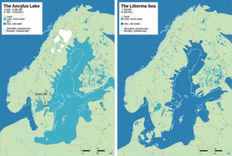
Figure 1.2. Thetwo most essential deglaciation stages were theAncylus Lake andthe LittorinaSea.
1.3.1The Baltic icelake
TheBalticIce Lake completely covered Ölandduringthe earlyphase of deglaciation. Soon after, as therelativesea
levelfelldue to theisostatic rise of the Baltic Shield,Öland graduallyemerged as agrowing andlargerisland. Today, the highest partsofÖland exceed 50 meters abovesea level. Thesebecamethe first shallowreefs or smallislands that eventually grew into Öland(Fig. 1.4).
Thesesmall islandshad athinlayer of till, whichthe waveswashedaway, eroded,and transported, leavingbehindbeach ridges with theremaining coarserparticles.
In Öland, thetwo stages,the AncylusLake andthe Littorina Sea, arethe most important as they have left significant morphologicaltraces:cf. thedescription below(Fig. 1.2).
Thesuspended fine fractions,suchasclay, silt, andfinesand, were depositedinthe waters around this early island as glacial lake sediments. Most of thesefiner soilsare not presentonÖland todaybecause they have been washed away duringsubsequent developmentinthe postglacial period.
However, they maystill be preservedin deeper depressions in thelandscape andare also foundbeneath coarserthinlayersof sand to thewestofthe Questa along the west coast.
Initially,the beachridge formed as asingle elongatedridge stretching from north to southontop of thebedrock Questa.This wascreated by stormwaves coming from boththe west andthe east.Eventually, as theinitialislandand more land gradually rose abovesea level, wavesand currents erodedthe depositedmaterial, forming beach ridges. Themostwell-developed beach ridges arenow foundalong the exposedeast-facing shores.Although westerly winds dominated,stormsfromthe eastwerestronger,and wavesfromthe opensea in theeastwerehigherand more potent.
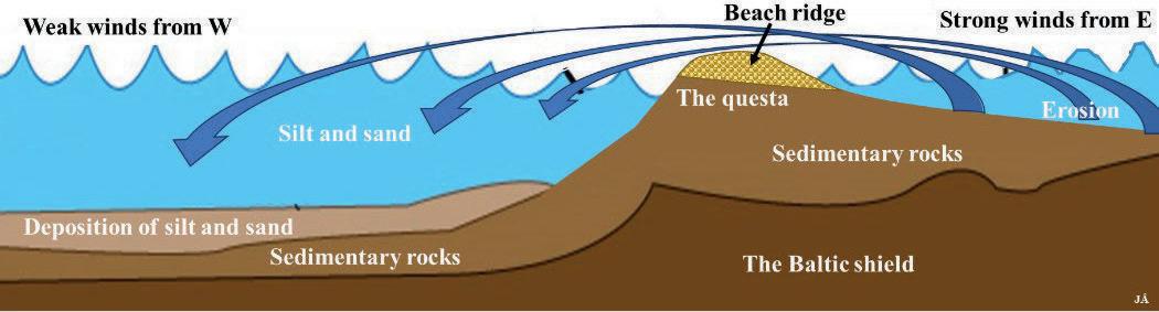
1.3. Schematicillustrationofthe material transportand sedimentationduring theBalticIce Lake period,ca12500 BP. (Fig.JÅ).
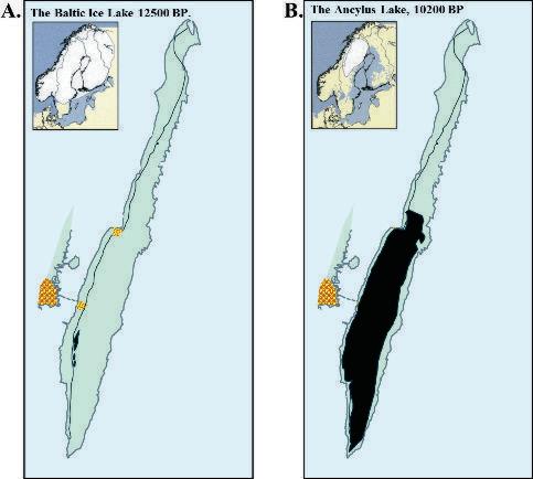
Figure1.4.The distribution of theA.BalticIce Lake,12500BPand B. theAncylus Lake,10200 BP,aroundÖland.Landareas in black. (Fromvarious sources)
Despite deglaciation, thefirst island and newparts of Ölandwereexposed to aharsh Arctic climate, andinitialvegetationbegan to establishitself. Thisvegetation resemblesthatfound in theNordic mountain range today. Speciessuchas Arctic mosses andlichens,aswellasplants such as theAlpinemeadow-grass (Poa alpina,L)inSwedish se.Fjällgröe, The Red Alpine Catchfly (Silene alpina,Lodd.)var
oelandica, se.Fjällnejlika, andthe MountainAvens (Dryas octopetala,L.),se. Fjällsippa (Fig.1 1.5),and theCommon Blue Daisy(Globularia vulgaris, L.), se. Bergskrabba also belongstothe southern alpine elementthatstill exists on Öland.
TheCommonBlueDaisy (Globularia vulgaris, L.)species hasa highly fragmented distributioninalpineregions, with one populationinthe mountains of
This book about Ölandisbased on guides andbackground material from theLund University course NGEA04“Ecosystemanalysis”,a fieldcourse held on Ölandeach Mayfrom2004 to 2025. Thematerialprovidesanintroduction andoverviewofÖland's physical geography,including itsgeneral physiographicand ecological features.The student’s guidehas now been expandedintothisbook to also serveasa guidefor generalvisitorstoÖland.The suggestedexcursion,with its listofstops,can serveasa starting point andresourcefor anyone visiting Öland. It is designed specificallyfor visitors seekinga broader, deeper understanding of theisland. Thematerialisn't just academic butmay appeal to anyone interested in nature whowants to learnmorebefore or duringa visittoÖland.Itcan also encouragefurther research andreading.
Thebook is part of aseriescalled“ÅKERMANEXCURSIONS, Learnmoreduring your visitortravel.”The firstissueisÖLAND I. TheSouthern Part.