


The Moncton Social Inclusion Committee (SIC) has partnered with the Human Development Council (HDC) to develop Neighbourhood Profiles for Moncton. This project will serve as a tool for guiding the SIC in implementing its action items effectively and ensuring resources are allocated where they are needed most.
The SIC has already established a robust foundation through its collaboration with HelpSeeker to produce two reports. The first was a Social Needs Assessment which used data from the 2021 Census and the New Brunswick Health Council.[1] The Social Needs Assessment provides an analysis of Moncton’s evolving social landscape, shaped by significant demographic change and growth. With a 23.9% population increase from 2006 to 2021 and a rising proportion of seniors, women in older age groups, Indigenous peoples, and immigrants, Moncton faces complex social challenges. These include unemployment, low income, housing unaffordability, homelessness, and mental health concerns, particularly among vulnerable groups like children in core housing need, seniors, one-parent families, and non-English or French-speaking immigrants. The assessment highlights the need for accessible services, targeted interventions, and better collaboration between government and non-governmental organizations. The report is available on the City of Moncton's website at moncton.ca/guides-moncton/social-inclusion.
The second report, the Social Inclusion Plan (2023–2027), outlined a roadmap for addressing these needs.[2] This plan highlighted a set of specific action items that depend on the creation of neighbourhood profiles and the identification of priority neighbourhoods.
In alignment with the Social Inclusion Plan, this report provides an analysis of Moncton’s priority neighbourhoods. It incorporates both qualitative data (input from local residents and key informants), and quantitative data (data analysis) which offsets the limitations of each method, and strengthens the analysis. The purpose of the Neighbourhood Profiles is to help the SIC target specific communities in the greatest need by focusing on issues such as affordable internet access, food security, community engagement, and support for vulnerable populations, such as low-income seniors and children.
Items from Moncton's Social Inclusion Plan that require the identification of priority neighbourhoods:
4.01a
Advocate for affordable internet plans with service providers, focusing on low-income households and underserved areas.
6.02a
Initiate community outreach in priority neighbourhoods identified through the neighbourhood profiles (2.O1.A). Engage residents to understand their needs and barriers, and tailor city programs to enhance their accessibility and appeal.
6.02b
Introduce a sliding fee scale or scholarship program, leveraging neighbourhood profiles (2.O1.A), to make city programs more accessible in targeted low-income areas.
8.01a
Establish outreach programs specifically designed for underrepresented communities, informed by neighbourhood profiles (2.O1.A). These programs should cover childcare and travel costs to remove barriers to participation in city meetings and consultations.
8.01b
Expand current communication channels beyond “Let’s Chat” and Council meetings by introducing community ambassador programs, door-to-door engagement, and other proactive efforts in parks and public spaces. Train volunteers and enlist Council and staff to engage the community in these various ways, using neighbourhood profiles (2.O1.A) for targeted outreach.
9.01e
Directly support targeted schools or areas struggling with high food insecurity, to better meet the needs of students and community members. Use the neighbourhood profiles (2.O1.A) to identify priority schools/areas.
9.02c
Collaborate with existing community food programs such as Headstart’s fresh produce box, the Peter McKee Centre’s food bank, and the Library’s food shelf to enhance their visibility and accessibility. Develop a public awareness campaign to inform residents of these resources, especially targeting underserved neighbourhoods based on neighbourhood profiles (2.O1.A).
13.01a
Use the neighbourhood profiles (2.O1.A) to identify areas with a higher proportion of older adults. Send targeted mail packages containing information on city resources, upcoming community events, and community-based support.
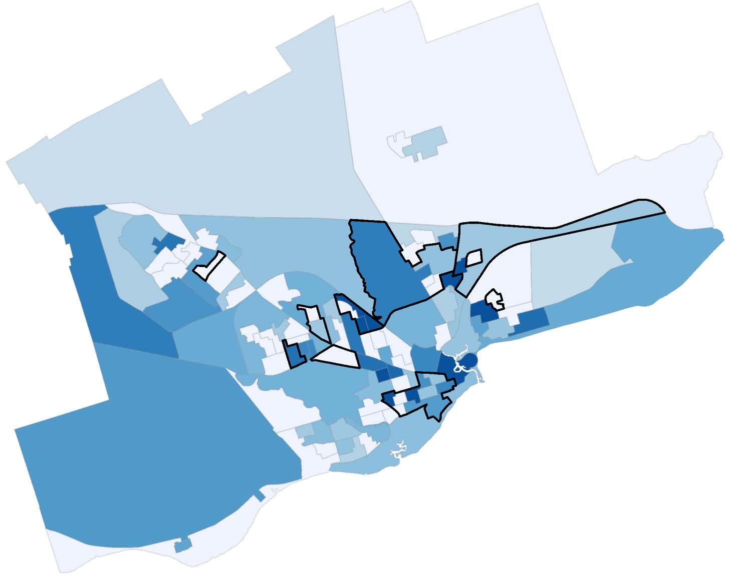
The map below shows the boundaries of Moncton’s priority neighbourhoods, which were defined using Dissemination Areas (DAs). DAs are a small neighbourhoodlevel geographic unit that Statistics Canada uses to release census data. DAs were used to outline priority neighbourhoods because they enable detailed data profiles to be created for each neighbourhood using the census.

Sources: Esri, Maxar, Earthstar Geographics, and the GIS User Community
The identification of these priority neighbourhoods was informed by a combination of both qualitative and quantitative data. Qualitative data was gathered through a community workshop hosted by the All In Agency. The key informants at the workshop used maps to outline priority neighbourhoods and provided insights into what the characteristics are that make a neighbourhood a priority.
The qualitative data was complemented by a comprehensive quantitative analysis. This analysis emphasized the use of recent data due to Moncton’s rapid population growth in recent years.
The SIC also played a crucial role in determining the priority neighbourhood boundaries. With their experience working and living in Moncton, the SIC members have insights into the nuances of the city’s neighbourhoods that cannot be fully captured by quantitative data alone. Their input helped adjust and confirm the final boundaries of the priority neighbourhoods.
The SIC will lead social inclusion initiatives in these communities. With limited resources available, a moderately conservative approach was used to select the priority neighbourhoods. To ensure effective resource allocation, areas with the greatest need in Moncton should be prioritized.
Based on combined data and community consultations, nine priority neighbourhoods were identified. To create these neighbourhoods, multiple DAs were merged into distinct regions. However, one recurring observation from both the community and the SIC was that DA boundaries do not perfectly reflect how residents and service providers define their priority neighbourhoods. For example, a single DA may include pockets of low-income housing as well as higher-income streets.
As a result, the boundaries shown on the map should be understood as approximate. They outline general areas with high needs but are not fixed or precise. In many cases, community members and front-line workers—whether in government, non-profits, or other organizations—have a more accurate understanding of where the greatest needs lie within specific streets or blocks.
Therefore, when services and community initiatives are implemented, these local insights should take precedence over the DA boundaries. The map and the accompanying neighbourhood data profiles are best used as tools to identify broad areas of need and to provide contextual, data-driven information. The following sections of this report explain how the priority neighbourhoods were identified, starting with qualitative findings and then outlining the quantitative analysis.

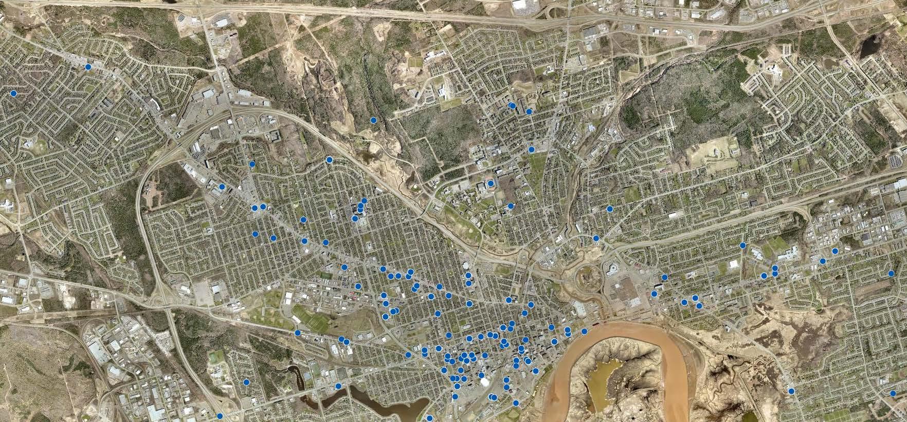
On November 12th, the All In Agency hosted a workshop at the Community Hub on Joyce to advance Moncton’s Social Inclusion Plan. The event brought together community leaders, people working in the non-profit and public sector, and individuals committed to fostering community well-being. Participants shared stories of recent social inclusion successes, explored community data, and discussed how to address barriers to inclusion.
As part of the workshop, the HDC led a mapping activity to identify priority neighbourhoods for social inclusion efforts. The session began with a brief presentation on community data, during which the HDC explained the concept of priority neighbourhoods. Participants then split into seven groups, and each of them was given a large satellite map of Moncton showing DAs.

Using coloured markers, the groups worked together to outline areas that they considered to be Moncton’s priority neighbourhoods by tracing DAs. After the mapping exercise, everyone completed a feedback form. The feedback form asked what types of information or data are relevant for determining priority neighbourhoods.
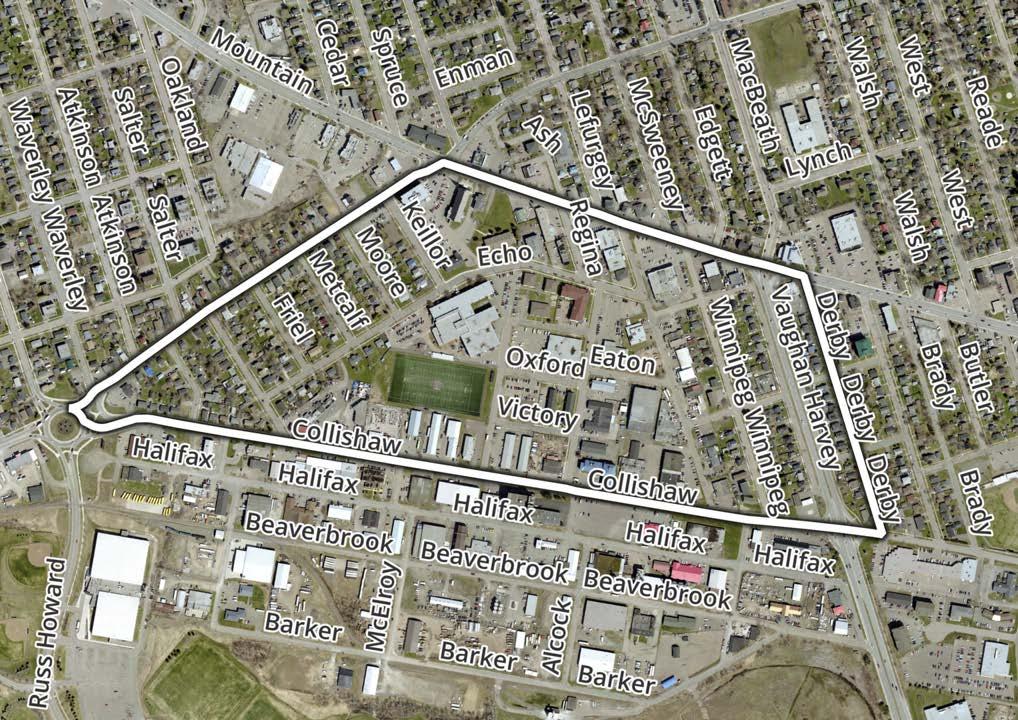
After the workshop, a digital representation of each of the seven maps was created. In some cases, participants outlined areas that differed slightly from the pre-defined DAs. For these areas, approximations were created and put onto the map. The following image shows the seven maps overlaid on top of each other. Areas of darker blue indicate that more of the groups selected that geography as a priority neighbourhood.

The following map images illustrate areas where workshop participants showed the highest levels of agreement. The first four maps highlight the areas with the strongest consensus. Most of the workshop participants selected these areas as priority neighbourhoods. The eight zoomed-in images that follow had less agreement but still warrant attention.


After participating in the workshop, community stakeholders were asked to complete a feedback form with the question: “What indicators are important in identifying priority neighbourhoods for social inclusion?” A total of 19 people responded, and their answers are represented in the wordcloud below.

The most commonly cited indicators were transportation, then income, and finally education. Equitable access to these resources is essential for enabling individuals and families to fully participate in their community.
Reliable transportation is crucial for accessing employment, education, healthcare, and social services. Without it, individuals may experience isolation, limited mobility, and reduced personal and economic growth. Furthermore, transportation facilitates social connection, helping people build a sense of belonging in their community. In priority neighbourhoods, public transportation is often a primary mode of travel.
Adequate income promotes higher quality of life overall. People with higher income levels have greater access to housing, healthcare, nutrition, cultural activities, and other resources. People with sufficient incomes are better equipped to meet their needs and pursue growth opportunities.
Education is fundamental for acquiring the skills necessary for gainful and meaningful employment. Lack of education often results in low-wage, precarious work and limits upward mobility.
A central theme that emerged from the community stakeholders’ responses is the critical need for accessible resources within priority neighbourhoods. These include social support services, mental and physical healthcare services, pharmacies, schools, libraries, community centres, recreational facilities, grocery stores, public Wi-Fi networks, public transportation, and more.
Community stakeholders also noted the link between income and household composition, highlighting that family structure can influence financial stability. One-parent families, for example, are at greater risk of experiencing poverty.
Food security was another concern, with stakeholders emphasizing the importance of having access to affordable, safe, and nutritious food.
Another theme from the qualitative data is affordability, and specifically, affordable housing. Stakeholders stressed the importance of affordable and subsidized housing within priority neighbourhoods. Access to safe, reasonably priced, and well-maintained housing is crucial. When housing is outdated or poorly maintained, it can lead to health and safety issues for residents. Stakeholders highlighted the value of having a range of housing stock options in priority neighbourhoods for renters and homeowners.
Embracing diversity is vital in promoting social inclusion. Stakeholders emphasized the importance of welcoming newcomers and immigrants to the community, as well as ensuring that spaces and services are inclusive and accessible to people with disabilities. When neighbourhoods champion diversity and inclusivity, they foster stronger senses of kinship and belonging for all residents.
The quantitative data analysis builds on and complements the qualitative insights gathered during the mapping exercise by reinforcing and contextualizing the key informants' findings. Five data sources are used in this analysis:
The Census:[3] The census has the largest set of indicators related to social inclusion and vulnerability, and the data is reliable at small geographies. It will provide the baseline data for determining priority neighbourhoods. The census is conducted every five years. The most recent data available is from 2021.
Social Assistance Recipients:[4] Data on the prevalence of social assistance recipients per DA was provided by the Department of Social Development. The prevalence of social assistance within a community is a direct measure of vulnerability because to qualify for it people must be in low income and have liquidated most of their assets.
Voter Turnout:[5] Voter turnout data from Elections NB is available at the polling division level. “Electoral districts/regions are subdivided into polling divisions. Each polling division usually includes 250-450 electors.”[6] Civic engagement or voter turnout is a useful indicator of vulnerability due to its correlation with demographics such as sense of community belonging, education, and income.[7]
T1 Family File (T1FF):[8] Taxfiler data from the T1 Family File provides information about income levels and poverty rates. Statistics Canada does not publicly release taxfiler data for DAs, however, it is available for census tracts (CTs) which are slightly larger. The most recent available T1FF data is from 2022.
211 Services:[9] To analyze the distribution of services, a snapshot of the 211 database was taken on October 15, 2024.
The following maps display data from the 2021 Census, plotted by DA. The first four maps show baseline population density and age distribution data. These indicators provide helpful context for interpreting the subsequent maps, which highlight more direct measures of marginalization, such as low income, core housing need, and related metrics.
It is important to note that DAs vary in population size. While percentages may appear similar across DAs, the actual number of individuals represented can differ significantly.[10]


This is a choropleth map, a type of heatmap, that visualizes data within specific geographic boundaries (DAs). The shading represents the intensity of a variable, with darker shades of blue indicating higher percentages or values and lighter shades representing lower percentages. The black lines mark the boundaries of Moncton’s priority neighbourhoods.
The example colour gradient, as shown in the legend, ranges from light blue to dark blue. Areas of light blue have values of 10% or less and areas of dark blue have values of 30% or more.
This type of visualization supports decision-making by highlighting areas that may require further attention. For example, if the variable represents a social inclusion challenge, the darkest blue areas of the map could indicate neighbourhoods with the greatest need for targeted support.
Population Density per Kilometre Squared
> 4,101

< 1,065
Analyzing population density is important for community engagement for several reasons. High-density areas offer the opportunity to reach more people and foster greater participation. These areas often have better access to public transit, making services more accessible, whereas lower-density areas may face more challenges in service delivery. Many of Moncton's priority neighbourhoods are characterized by high population density. Priority neighbourhoods typically have fewer large single-family homes, resulting in a more concentrated population.

Children Aged 0 to 14 > 19% < 8%
Analyzing age distributions alone does not directly measure a neighbourhood's vulnerability. However, basic demographic information, such as age, provides context for other metrics that more directly measure the challenges faced by communities. In Moncton, the highest concentrations of children are found in suburban neighbourhoods outside the central city.

Working-Age People 15 to 64
> 74% < 58%
Individuals aged 15 to 64 are generally considered the working-age population. Recent research indicates a growing prevalence of low income among single working-age individuals.[11] Low-wage workers, in particular, often find themselves ineligible for certain support programs while still struggling to cover essential living expenses.

Aged 65 Plus > 30% < 10%
Rising costs and affordability challenges can disproportionately impact seniors, as many rely on fixed incomes from benefits and pensions. In Moncton, certain neighbourhoods have higher concentrations of seniors. In some areas, this is partly due to the presence of seniors' complexes like Résidence Moncton and Villa Du Repos. However, that is not the case for all neighbourhoods.
Median After-Tax Income of Households
> $80,720

< $37,227
Household income is a good metric for assessing well-being, as members of a household typically share resources, regardless of its composition. Senior households and single adults often have lower household incomes due to their smaller household size. Some of the lowest household incomes in Moncton are concentrated in areas, such as the downtown neighbourhoods, along Mountain Road, and near seniors' complexes.
Median After-Tax Income of Individuals
> $39,441

< $27,668
The distribution of individual income closely mirrors that of household income. Priority neighborhoods—particularly neighborhoods one, two, and four—have some of the lowest incomes in Moncton.
32%

7%
The Low-Income Measure, After Tax (LIM-AT) is a way to identify households with low income. It sets the threshold at 50% of the median (middle) household income in Canada. For example, if the median household income is $60,000, families that have less than $30,000 are in low income. Since larger households require more income to meet their needs, the threshold is adjusted based on household size. The LIM-AT offers several advantages. First, it adjusts for different family sizes. Additionally, it takes into account income inequality by highlighting the percentage of people falling behind relative to the rest of the population.
In Moncton, the highest concentrations of low-income are found in the downtown area, two communities near central Mountain Road, around certain seniors' complexes, and in two communities in eastern Moncton. The distribution of low income is also not the same across age groups as shown in the maps below. The highest concentration of low income for people 15-64 is downtown, while there are pockets of communities with children and seniors in low income throughout Moncton.

% of the Population that are Low-Income, Aged 0 to 5
> 3%
< 0%

% of the Population that are Low-Income, Aged 0 to 17
> 8%
< 0%

% of the Population that are Low-Income, Aged 18 to 64
> 19% < 3%

% of the Population that are Low-Income, Aged 65 Plus > 9% < 0%

Core Housing Need > 21% < 1%
Core housing need is a way to measure whether people have adequate housing that meets basic standards. A household is considered in core housing need if: they spend more than 30% of their income on housing, the home is in poor condition and needs major repairs, or the home is too small for the number of people living there. If a household has one or more of these problems and cannot afford housing that meets these criteria in their area, they are in core housing need.[12]
The areas with high core housing need generally align with those of low income, but there are some exceptions. For instance, certain DAs north of the downtown area show high core housing need, despite not having correspondingly high levels of low income.

% of Households Spending 30% or More of Income on Shelter > 35% < 7%
The threshold for housing affordability is 30% of household income.[13] If a household spends more than that on housing, it is considered unaffordable. Core housing need is a more robust indicator, however, because it not only considers affordability, but also adequacy and suitability.

> 85% < 14%
Renters in New Brunswick have been facing unprecedented affordability challenges in recent years. While the largest concentration of renters is located in downtown Moncton, there are also several other pockets across the city with high proportions of renters above 85%.

% of Renter Households Living in Subsidized Housing
> 21%
< 0%
Subsidized housing was a significant theme in the qualitative data as an indicator of a priority neighbourhood. To qualify for subsidized housing, individuals must have considerably low incomes, and neighbourhoods with high concentrations of subsidized housing often reflect areas facing socio-economic challenges. Ideally, neighbourhoods are mixed-income, promoting diversity and avoiding high concentrations of low-income households.
In Moncton, the majority of DAs have 0% of their rental units subsidized. However, certain neighbourhoods stand out with a high prevalence of subsidized rental units, many of which are identified as priority neighbourhoods. The DAs in grey had no rental units and therefore no data.

> 15% < 2%
As previously mentioned, outdated or poorly maintained housing can pose significant health and safety risks for residents.
In Moncton, the majority of housing requiring major repairs is concentrated in the central part of the city, with additional pockets in the eastern downtown area. Specifically, neighbourhoods located between Mountain Road and the highway show particularly high proportions of housing in need of significant repairs.
Housing Built 1960 or Before
> 67% < 1%

The map above highlights Moncton's oldest neighbourhoods. While not all older neighbourhoods correspond to priority or low-income areas, residents in lowincome neighbourhoods with aging and poorly maintained housing can face additional financial burdens. These include higher shelter costs due to energy inefficiency and the increased upkeep required to maintain older housing stock.

> 35% < 11%
One-parent families are an important demographic often facing unique social and economic challenges. These include balancing childcare responsibilities while meeting basic needs for multiple people on a single income.
The prevalence of one-parent families is correlated with a high concentration of low-income and closely aligns with Moncton's priority neighbourhoods.

Ages 25 to 64 No
Certificate Diploma or Degree
> 25%
< 2%
Education is another key indicator of a priority neighbourhood. While it does not directly measure poverty, it is closely associated with various socio-demographic outcomes.
In Moncton, there are several scattered neighbourhoods with a high concentration of individuals with no educational attainment. One area, in particular, stands out with the highest prevalence of low educational attainment—located along Mountain Road and intersecting with two of the city’s priority neighbourhoods. This pattern is unique compared to other indicators and highlights an opportunity for intervention. Programs aimed at improving educational attainment should consider targeting this area.

Participation Rate > 74% < 50%
Labour force participation refers to the percentage of the population aged 15 years and older who are in the labour force. Areas with higher proportions of seniors typically have lower labour force participation rates.

Unemployment Rate
> 23% < 5%
The unemployment rate is the percentage of the labour force that is actively seeking but unable to find employment during a given period. Interestingly, many neighbourhoods in the downtown area do not exhibit the highest unemployment rates, despite being priority neighbourhoods.

> 20% < 4%
Immigrants are a growing population in Moncton, often facing challenges related to housing, employment, and integration. The experience of immigration can vary significantly depending on the neighbourhood. There is a notable concentration of immigrants around Woodhaven Court. Some of Moncton's priority neighbourhoods also have a high proportion of immigrants.
Additional barriers for immigrants include not having permanent residency status or being unable to speak either English or French. Non-permanent residents, such as temporary workers and international students, may have limited access to support systems. For individuals who do not speak English, there is a greater need for support that can assist with language proficiency and overall integration into the community. The following maps show the distribution of non-permanent residents and people who do not know English or French.

Non-Permanent
Residents

< 0%

No Knowledge of Either English or French
> 2%
< 0% > 17%

Movers in the Past 5 Years
> 75% < 34%
Movers in the past five years are individuals who changed their usual place of residence within the five years prior to the census date. Moving can place a significant strain on low-income households, particularly in priority neighbourhoods.
The neighbourhood with the highest proportion of movers is the DA encompassing much of the housing around the Community Hub on Joyce, with 78% of residents having moved in the 5 years before the Census.
Indigenous Identity > 6% < 0%
Analyzing the distribution of Indigenous populations can help guide culturally appropriate community initiatives and services.
One DA along St. George Street had the second-highest proportion of residents identifying as Indigenous, at 13%. The area to the left of priority neighbourhood nine had the highest proportion at 14%.

Racialized Population
> 40% < 5%
Moncton's priority neighbourhoods often have high concentrations of racialized people. The areas with the highest proportions of racialized people in the city include a section of downtown, parts of priority neighbourhood seven, and priority neighbourhood nine.

Activity Limitation (Always, Often or Sometimes Limited)
> 66% < 40%
Activity limitations data from the 2021 Census refers to information about individuals who experience difficulties with daily activities, such as seeing, hearing, walking, or cognitive functioning, due to a physical, mental, or emotional condition. This group includes anyone who identifies as having "a lot of difficulty" or "some difficulty" performing certain tasks.[14]
While activity limitations are not the same as disability, which typically requires a formal diagnosis, this data serves as a useful proxy for identifying populations that may need additional supports.[15]
The map above highlights several areas within Moncton where rates of activity limitations exceed 60%, indicating areas of individuals facing greater challenges with daily activities.
Using data from the New Brunswick Department of Social Development, the following map illustrates the percentage of people on Social Assistance by DA. This percentage was calculated by dividing the number of individuals actively receiving Social Assistance at a specific point in 2024 by the 2021 Census population for each DA.
While the percentages may not fully reflect the exact 2024 values due to the use of 2021 population data as a proxy, the map still effectively highlights concentrations of Social Assistance recipients.
According to the map, seven neighbourhoods have the highest Social Assistance rates colored in dark blue. Notably, six of these were identified by multiple groups during the workshop mapping exercises. The seventh neighbourhood was also recognized in the mapping exercise, though only by one group.

% of People on Social Assistance
The patterns in voter turnout at the polling division level are similar to those seen in census data at the DA level. Many polling divisions with low voter turnout are in neighbourhoods with low income, core housing need, and a high prevalence of social assistance.
The map below shows voter turnout from the 2020 provincial election by polling division. Many of the polling divisions with low voter turnout match the neighbourhoods highlighted by key informants at the workshop. The grey polling division was missing data.

Voter Turnout 2020 Provincial Election
A more recent source of data than the 2021 Census is tax filer data, which provides low income rates for CTs for 2022. The map below shows low-income rates for CTs in the City of Moncton. It is important to note that tax filer data and census data use different measures of low income.
The census uses the Low-Income Measure After Tax, while tax filer data uses the Census Families Low-Income Measure After Tax.[16] Even with these differences, both are valid ways to estimate low income and show similar patterns in where low-income populations are concentrated.

Examining the data at larger geographies reveals patterns that are not as clear when focusing solely on DAs. Low-income rates by CT show that areas near the city centre have higher rates. Urban neighbourhoods closer to the inner city have the highest low-income rates in Moncton.
Specifically, the CT that intersects priority neighbourhood one has a low-income rate exceeding 44%. This aligns with feedback from workshop participants, who highlighted this area as a top candidate for priority neighbourhood status.
The map on the next page shows which DAs correspond to specific CTs.

Dissemination Area and Census Tract Boundaries
Census Tracts
Dissemination Areas
The final data source is the 211 database, which is visualized on the map below. Each blue dot represents a unique service. The highest concentration of services is in the downtown area, spanning from St. George Street to Main Street. Another area with a high concentration of services is along Mountain Road, although they become less prevalent as you move further west. This trend of services being concentrated downtown and along the eastern part of Mountain Road is also evident for services directly addressing basic needs, such as housing/shelter, health support, and mental health.
Concentration of 211 Services
Sources: Esri, Maxar, Earthstar Geographics, and the GIS User Community
A neighbourhood profile is a detailed demographic overview of a specific area using data from the 2021 Census. The information is based on the DAs to which priority neighbourhoods correspond.
The data tables include profiles of the nine priority neighbourhoods in Moncton and a profile of Moncton itself as a benchmark. The tabular format of the data encourages comparisons of the neighbourhoods to Moncton overall and between the neighbourhoods themselves. The profiles help display what makes each neighbourhood unique.
2021 Census
Population
Population
Land Area km²
Pop Density People/km²
Ages 0-4
Ages 0-14
Ages 15-64
Ages 65 and Over
Ages 85 and Over
Low Income (LIM-AT) In Low-Income
% of the Pop that are Low-Income, Aged 0-5
% of the Pop that are Low-Income, Aged 0-17
% of the Pop that are Low-Income, Aged 18-64
% of the Pop that are Low-Income, Aged 65+
Nbhd 1
First Language Spoken
English Only
French Only
English and French
Neither English or French
Immigration and Ethnicity
Canadian Citizens
Immigrants
% of Immigrants Arrived 2016 to 2021
Non-Permanent Residents
% of Immigrants 1980-2021 that are Refugees
Indigenous Identity
Racialized People
Housing
Renters
% of Renters Living in Subsidized Housing
Renters Spending > 30% of Income on Housing
Renter Core Housing Need
Owners
Owners Spending > 30% of Income on Housing
Owner Core Housing Need
Housing Needing Major Repairs
Housing Built 2016-2021
Housing Built Before 1960
Moved in the Past Year
Moved in the Past 5 Years
Education Ages 25 to 64 High School Graduate
No Certificate, Diploma or Degree
Labour Force Ages 15+
Unemployment
Family Composition
Married Couple With Kids
Married Couple No Kids
Common Law Couple With Kids
Common Law Couple Without Kids
One-Parent Families
Woman+ One-Parent Families
Man+ One-Parent Families
While all the neighbourhoods listed in the table are considered priority neighbourhoods, there is significant variation in the metrics among them. Each neighbourhood is distinct, facing its own set of unique challenges.
Low income, housing, and immigration/citizenship exhibit significant variation across priority neighbourhoods. In terms of low income, each priority neighbourhood exceeds Moncton's overall rate; however, there are notable differences when looking at specific age groups. For instance, the proportion of the total population that are children in low income ranges from 4.3% to 19.2% across neighbourhoods, while the percentage for low-income seniors ranges from 1.1% to 10.1%.
With respect to housing, some areas have no subsidized rental units, while another has over 60% of its units subsidized. Immigration also shows a wide range in the proportion of refugees (from 1980 to 2021). While some neighbourhoods have no refugees, others have over 60% of their immigrant population arriving as refugees.
Another way to interpret the data is through the infographics provided on the following pages. Each page highlights a specific neighbourhood, providing a concise and visually engaging summary of key data for easy reference.
1
2021 Population
4,244
1.2 Land Area km²
2021 Population Density
3,627

Couples No Children
Couple Families With Children (… Couple Families Without Childr… One-Parent Families (22.45%) Couples With Children
One-Parent Families
Sources: Esri, Maxar, Earthstar Geographics, and the GIS User Community

Sources: Esri, Maxar, Earthstar Geographics, and the GIS User Community

Sources: Esri, Maxar, Earthstar Geographics, and the GIS User Community

Sources: Esri, Maxar, Earthstar Geographics, and the GIS User Community

Sources: Esri, Maxar, Earthstar Geographics, and the GIS User Community

Sources: Esri, Maxar, Earthstar Geographics, and the GIS User Community

Sources: Esri, Maxar, Earthstar Geographics, and the GIS User Community

Sources: Esri, Maxar, Earthstar Geographics, and the GIS User Community
This section provides additional neighbourhood-level data to support components of the Social Inclusion Action Plan that require a deeper examination of specific issues. While most action items broadly target underserved or priority neighbourhoods, some focus on addressing particular challenges within Moncton's neighbourhoods.
Moncton’s priority neighbourhoods were defined using a wide range of vulnerability indicators to identify communities facing the greatest challenges and highest levels of marginalization. For action items 4.01a, 6.02a, 6.02b, 8.01a, 8.01b, and 9.02c, the established priority neighbourhood boundaries are sufficient for determining where to focus efforts. These five items address underserved, lowincome, or priority areas in general, which aligns directly with the definition of priority neighbourhoods.
However, action items 9.01e and 13.01a aim to address specific issues within communities, such as food insecurity in schools and sharing community support information with seniors. In these cases, the areas most affected by these specific issues may not perfectly overlap with the broader priority neighbourhood boundaries.
This section takes a closer look at these three action items by analyzing neighbourhood-level data. By identifying the neighbourhoods most impacted by specific issues, resources can be allocated more effectively to address these targeted needs.
Directly support targeted schools or areas struggling with high food insecurity, to better meet the needs of students and community members. Use the neighbourhood profiles (2.O1.A) to identify priority schools/areas.
Food insecurity can arise from various factors, including low income, limited access to food due to disability, or residing in food deserts where quality food options are not readily available within the community.
Obtaining precise data on food insecurity at the neighbourhood level can be challenging.
As a result, low income is used as a proxy measure for food insecurity. Action item 9.01e aims to address food insecurity in schools located in neighbourhoods with high levels of need. Since this item targets schools, thereby targeting children, identifying relevant neighbourhoods will involve analyzing areas with high concentrations of children living in low-income within the City of Moncton. This analysis will then be used to determine which schools fall within these neighbourhoods. The following map shows the prevalence of children in lowincome and the locations of Moncton's schools.[17]

Sources: Esri, Maxar, Earthstar Geographics, and the GIS User Community
The schools highlighted in yellow on the map were identified as priorities due to their proximity to low-income neighbourhoods. Schools farther from low-income areas are shown in black. The following schools are the ones highlighted in yellow:
Forest Glen School
Birchmount School
Beaverbrook School
Queen Elizabeth School
École Saint-Henri
Harrison Trimble High School
École L'Odyssée
École le Mascaret
Edith Cavell School
Use the neighbourhood profiles (2.O1.A) to identify areas with a higher proportion of older adults. Send targeted mail packages containing information on city resources, upcoming community events, and community-based support.
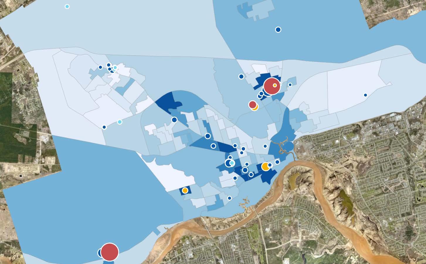
Special Care Home
Seniors with low incomes often require the greatest support from their community. As the cost of living continues to rise, those relying on fixed, limited incomes are among the most affected. The following map highlights neighbourhoods in Moncton with a high concentration of low-income seniors and shows the locations of the city’s senior complexes.[18] % of the Pop that are Low-Income, Aged 65+
Specialized Care Bed Home
Senior Complex Licensed Nursing Home
Beds

The color coding on the map follows the same pattern as the other maps in this report. DAs shaded in darker blue indicate higher concentrations of low-income seniors, while lighter shades represent lower percentages. The colored dots represent Moncton’s senior complexes, with each colour corresponding to a specific type: dark blue dots for Special Care Homes, light blue dots for Specialized Care Bed Homes, red dots for Licensed Nursing Homes, and yellow dots for Senior Complexes. Additionally, the size of the dots reflects the capacity of each facility, with larger dots indicating more beds and smaller dots representing fewer beds.
Several distinct patterns emerge from the map. First, five neighbourhoods stand out as having high concentrations of low-income seniors. These neighbourhoods include areas south of St. George Street, near Villa Du Repos, near Camden Park Terrace, around Kiwanis Park, and in the Fairlane Drive neighbourhood.
Among these neighbourhoods, three—south of St. George Street, near Villa Du Repos, and near Camden Park Terrace—have a high concentration of senior complexes. Notably, the area near Villa Du Repos has the highest number of facilities and the largest capacity in terms of beds. This highlights it as a central hub for senior care services within the city.
However, the remaining two neighbourhoods, around Kiwanis Park and the Fairlane Drive neighbourhood, also have a high proportion of low-income seniors but lack senior complexes within their DAs. This indicates potential service gaps in these areas.
Overall, the demographic data indicates that areas with higher concentrations of low-income seniors often coincide with clusters of care facilities, suggesting a degree of alignment between service locations and demographic need. However, some vulnerable areas, particularly in less dense regions, may lack nearby facilities, raising concerns about equitable access to senior care services.
The Neighbourhood Profiles project marks a significant step forward in Moncton’s ongoing efforts to foster social inclusion. Guided by the Social Inclusion Plan (2023–2027) and informed by both quantitative and qualitative data, these profiles offer a picture of the city’s priority neighbourhoods and the key challenges they face. By layering census data, social assistance figures, voter turnout rates, and insights from community stakeholders, this initiative sheds light on where Moncton’s most pressing vulnerabilities lie, from high rates of low income and core housing need to limited educational attainment and service access.
A key outcome of this work is the identification of nine priority neighbourhoods that demonstrate consistently high levels of vulnerability. These areas will benefit most from targeted supports, whether through affordable internet access, enhanced community outreach, expanded program affordability, or outreach initiatives for seniors and families. The maps and data tables in this report also highlight additional hotspots for specific challenges—such as food insecurity among children or supports for low-income seniors—underscoring the importance of a nuanced approach to resource allocation.
Moving forward, the City of Moncton and its partners, through continued collaboration and a commitment to inclusive policy-making, can help ensure that every resident has the opportunity to thrive.
1. HelpSeeker Technologies. (n.d.). Social Needs Assessment: Moncton. City of Moncton. https://www5.moncton.ca/docs/social-needs-assessment.pdf
2. HelpSeeker Technologies. (n.d.). Better Together: Moncton’s Social Inclusion Plan 20232027. City of Moncton. https://www5.moncton.ca/docs/social-inclusion-plan.pdf
3. Statistics Canada. (2022). Census Profile, 2021 Census of Population. Statistics Canada. https://www12.statcan.gc.ca/census-recensement/2021/dppd/prof/details/download-telecharger.cfm?Lang=E
4. Department of Social Development, NBCase system as of December 13, 2024.
5. Elections New Brunswick. (n.d.). Provincial Election Results. https://www.electionsnb.ca/content/enb/en/resources/publications/election-results.html
6. Elections New Brunswick. (n.d.). Glossary. https://www.electionsnb.ca/content/enb/en/resources/toolkit/glossary.html
7. Elections Canada. (2020, March 4). Explaining the Turnout Decline in Canadian Federal Elections: A New Survey of Non-voters. https://www.elections.ca/content.aspx?section=res&dir=rec/part/tud&document=correlates&lang=e
8. Statistics Canada. (2024). Annual Income Estimates for Census Families and Individuals (T1 Family File). Statistics Canada. https://www23.statcan.gc.ca/imdb/p2SV.pl?Function=getSurvey&SDDS=4105
9. 211 New Brunswick. Search. https://nb.211.ca/search/
10. HelpSeeker Technologies. (n.d.). Social Needs Assessment: Moncton. City of Moncton. https://www5.moncton.ca/docs/social-needs-assessment.pdf
11. White, A., DiBellonia, S., & Tabbara, M.-D. (2024). Warning signs: Poverty in Canada. Maytree. https://maytree.com/publications/warning-signs-poverty-in-2022/
12. CMHC: Canada Mortgage and Housing Corporation. (n.d.) Understanding core housing need. https://www.cmhc-schl.gc.ca/professionals/housing-markets-data-andresearch/housing-research/core-housing-need
13. Statistics Canada. (2022). Households that spent 30% or more of income on shelter costs, Canada, 2011 to 2021. Statistics Canada. https://www12.statcan.gc.ca/censusrecensement/2021/as-sa/fogsspg/alternative.cfm?topic=7&lang=E&dguid=2021A000011124&objectId=4a 14. Statistics Canada. (2024). Target group profile of population with activity limitations, Census, 2021. The Community Data Program (CDP). https://communitydata.ca/data/target-group-profile-population-activity-limitations-census2021
15. Ibid.
16. Pinard, D. (2018). Methodology Changes: Census Family Low Income Measure Based on the T1 Family File. Statistics Canada. https://publications.gc.ca/collections/collection_2018/statcan/75f0002m2018001-eng.pdf
17. Open Data City of Moncton. (n.d.). Home. City of Moncton. https://open.moncton.ca/
18. Ibid.
19. Esri. "Imagery" [basemap]. Scale Not Given. "World Imagery". Dec 12, 2009. https://www.arcgis.com/home/item.html?id=10df2279f9684e4a9f6a7f08febac2a9
20. Maps throughout this book were created using ArcGIS® software by Esri. ArcGIS® and ArcMap™ are the intellectual property of Esri and are used herein under license. Copyright © Esri. All rights reserved. For more information about Esri® software, please visit www.esri.com.