P O R T F O L I O
SHHRRUTI JAIN
s e l e c t e d w o r k s l 13’ - 22’


This document is meant to create a reflective record of my selective academic, professional and competition works, which includes not only the intentions outlined for each project but also notes the challenges, implementation process, successes, failures and learnings for the future. I humbly present my architectural journey so far with a hope of further equipping myself in the realm. Thank you!


2
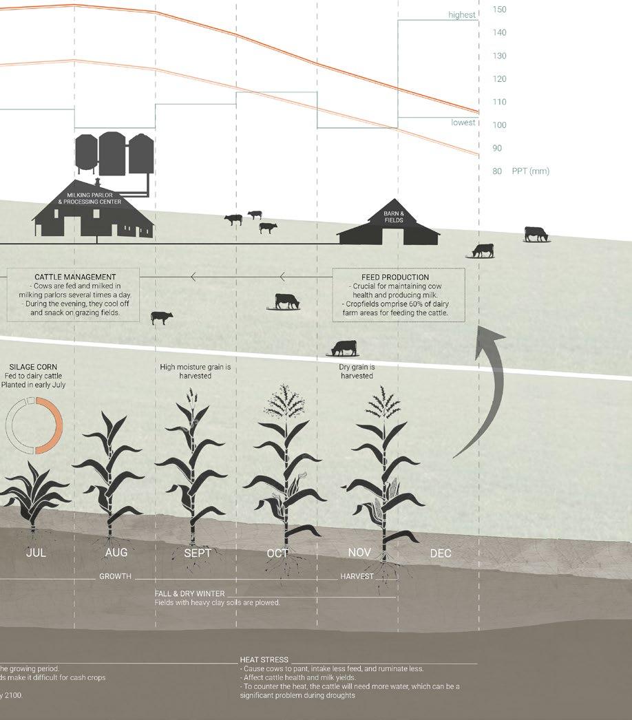
INSTITUTE OF REGENERATIVE PRACTICES Education as an Urban Design Intervention INDIGENOUS OCCUPATIONS Center for Skill Development 01 37 21 45 13 41 29 53 ARISE Mapping and Analysis NEIGHBORHOOD ANALYSIS FOR STUDENT HOUSING GIS and Mapping BRICK BY BRICK Hands-On Urban Design ETHICS AND AESTHETICS Bamboo Eco-Cottage RE-INCARNATION Architecture and Discourse ARCHITECTURE OF ECONOMIC PRESSURE Center for Human Interaction ARCHITECTURE AND THE COMMUNITY ARCHITECTURE AS A RESPONSE TO CONTEXTUAL IDENTITY ARCHITECTURE VIA PARTICIPATION ARCHITECTURE BEYOND THE BUILT TABLE OF CONTENTS 01 05 03 07 02 06 04 08
PROJECT DETAILS
Academic Work Studio Project Spring 2022 Guided by Professor Anna Dietzsch
Team Members: Polen Guzelocak
Rabei Javaid
Shhrruti Jain
My contribution: Analysis & design
Link to Research Work: https://storymaps.arcgis.com/stories/
Link to Design Proposal: https://storymaps.arcgis.com/
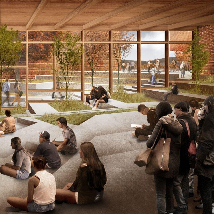
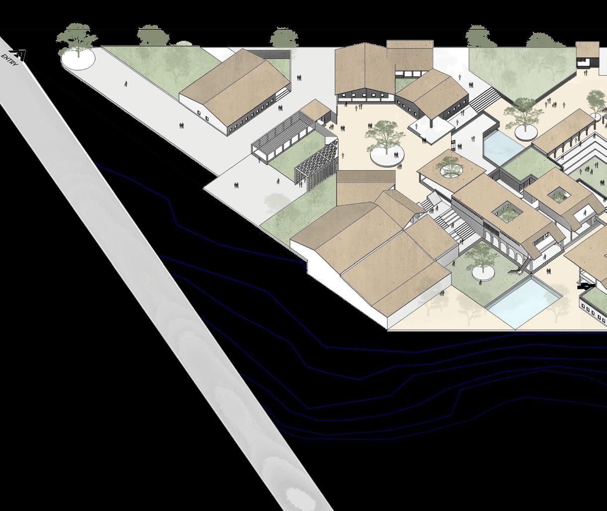
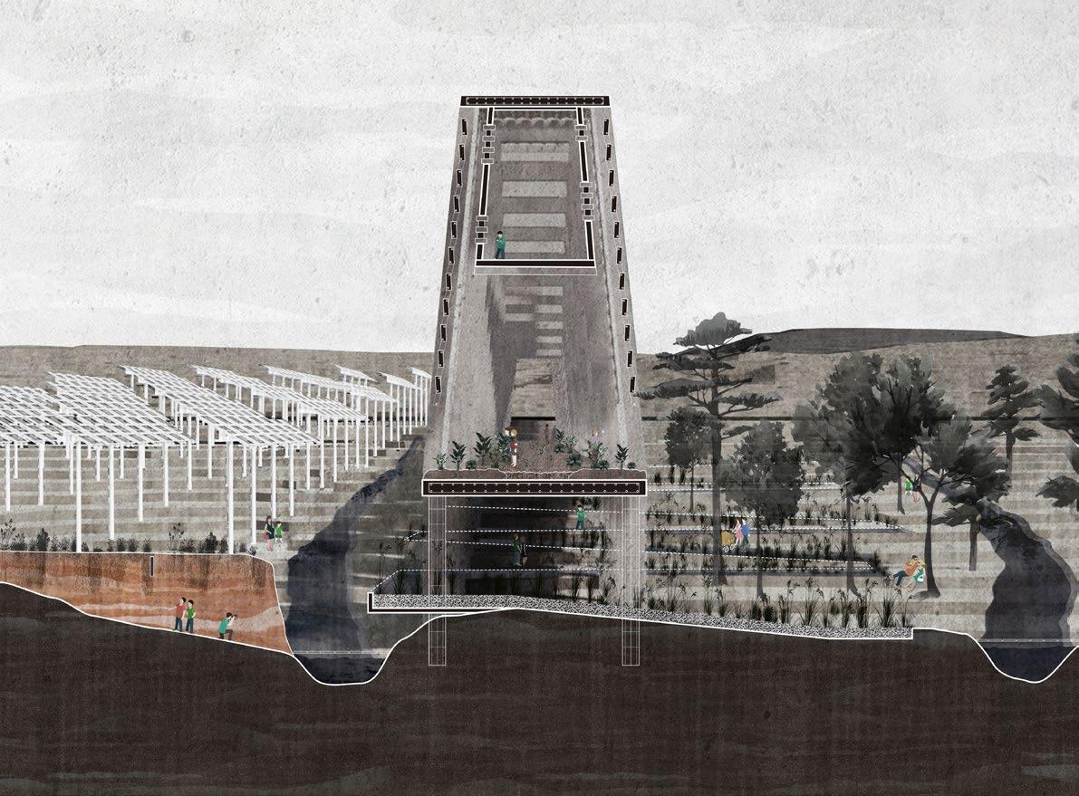
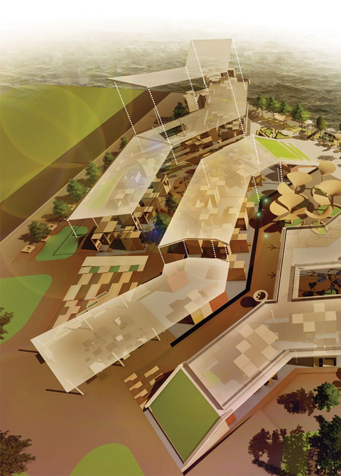
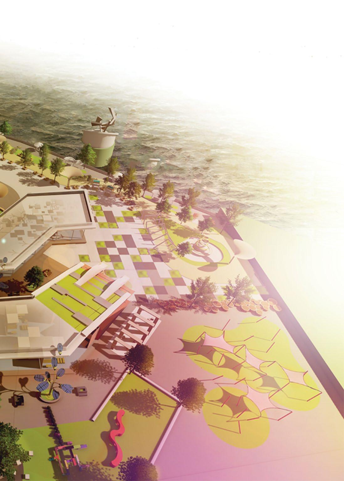
INSTITUTE OF REGENERATIVE PRACTICES
EDUCATION AS AN URBAN-DESIGN INTERVENTION STUDIO, CORNELL UNIVERSITY SALAMANCA, NY
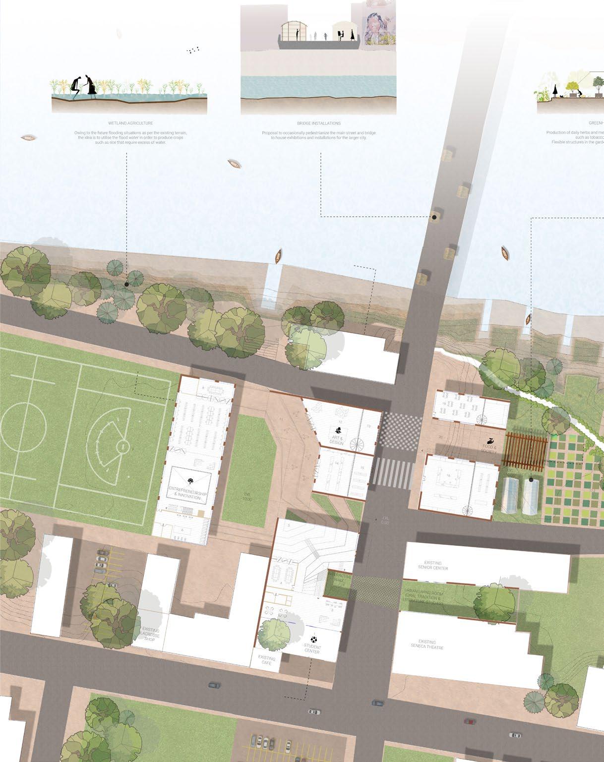
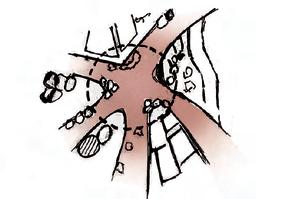
Can a built environment serve as a craddle fostering dialogue, movement, and capital within a city? Can it avert the collapse of a multigenerational material-cultural tradition?
For the Haudenosaunee society, life has always been about balance. They have always aimed to ensure an abundance of resources not only for their present-day but also for their future generations. However, their ability to ensure the continuity of resources in terms of food, social organization, and art practices is haltered today due to economical and political distress. Despite the diverse and colorful array of culture and traditional practices, the Seneca Nation Comprehensive Economic Plan and community surveys indicate that the poverty rates are very high in the city of Salamanca, especially for people who opt-out of higher education.
To improve the current state of affairs, a multigenerational engagement approach leveraging and benefiting the community is needed. Thus, this project aims to revitalize Salamanca with a multidisciplinary indigenous professional school that integrates and fosters the rich cultural practices of the community whilst taking part in economic and social development.
01 01
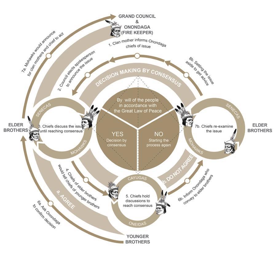
THE HAUDENOSAUNEE POLITICAL STRUCTURE ENSURING THAT THE POLITICAL LEADERS OF THE CONFEDERACY RESPECT THE WILL OF THE PEOPLE AND THE GREAT LAW OF PEACE


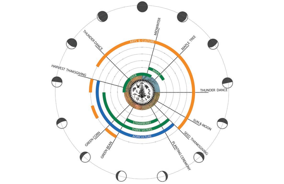
FORMULATION OF AN ACADEMIC CURRICULUM AND CALENDER BASED ON HAUDENOSAUNEE CULTURE AND CEREMONIES THESE ARE BASED ON THE LUNAR CALENDAR AND MAJOR CROP CYCLES Present: Weakening links Past: Continuation of resources A connected safe space Existing disconnect within the city Spaces weaved into the existing city’s faricProposed Future
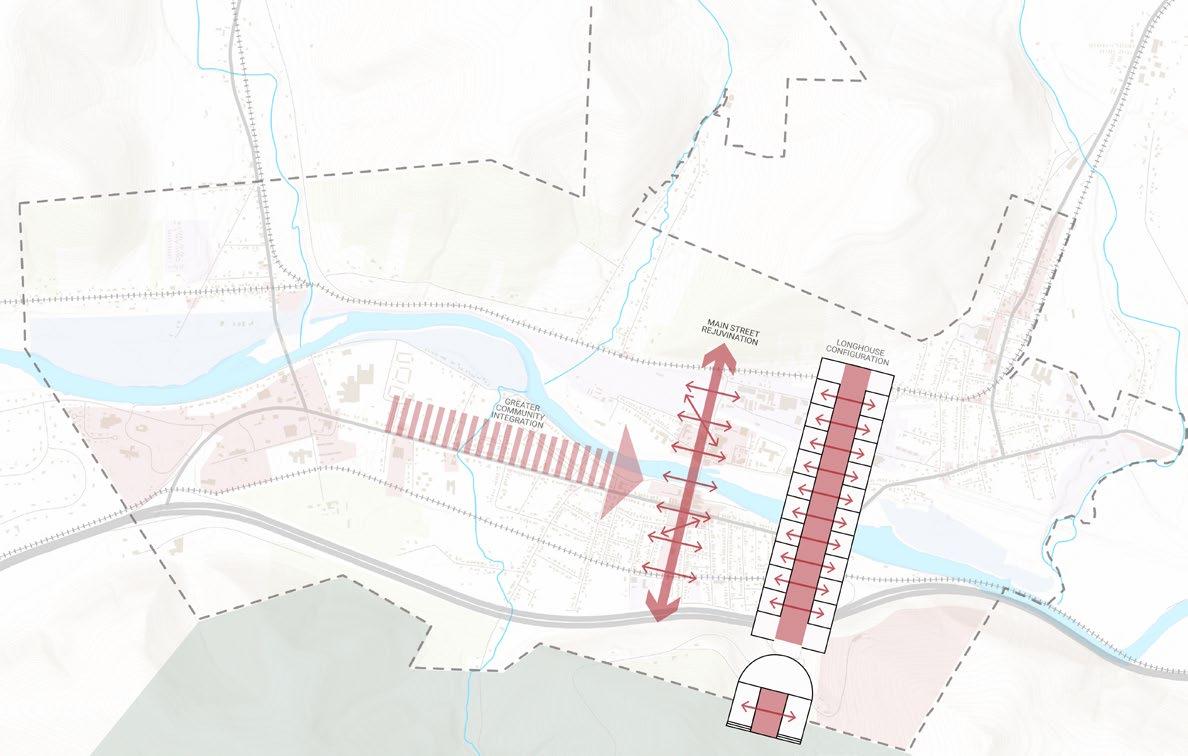
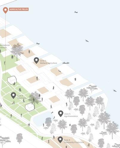
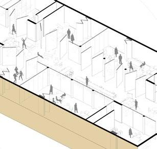
Main streets are the heart of our cities, places of shared memories and economic activities. However, with several of its buildings either shut or in a dilapidated condition, Salamanca’s main street is completely devoid of people. The project therefore aims to revitalize the old downtown main street via planning and designing of educational practices that foster greater community integration and foster the rich culture of the Haudenosaunee society. The inspiration to revitalize the street comes from the long house concept of the Haudenosaunee culture, both metaphorically and literally. The longhouse has a common central axis flanked by semi-private spaces. The main street has been envisioned as a long house which is activated by the existing and new structures and programs that are made of flexible convertible spaces.
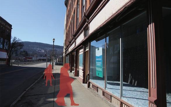
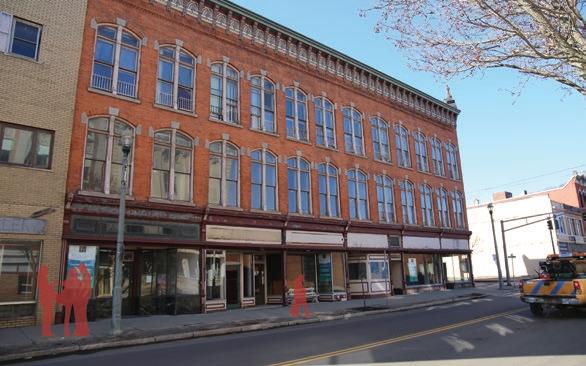
WHERE ARE THE PEOPLE?

03
A university in the form of an isolated safe space could preserve the culture but it would be inefficient in erasing the existing isolation within the city. The idea is to weave the educational practices within the main street such that it generates the necessary dialogue between the local community and students. What distinguishes the university is the fact that although each student would be gaining professional expertise in their respective concentrations, the notion of being involved in food cultivation would bind the student and local community to the land, which was the very basis of Haudenosaunee practices. There is further integration of the existing arts and crafts infrastructure within the main street such that these would serve as models for a holistic learning experience. Entrepreneurship and innovation practices comprise subjects that would facilitate the students to ace their standing in the global setting.
SPATIALIZING THE CURRICULUM

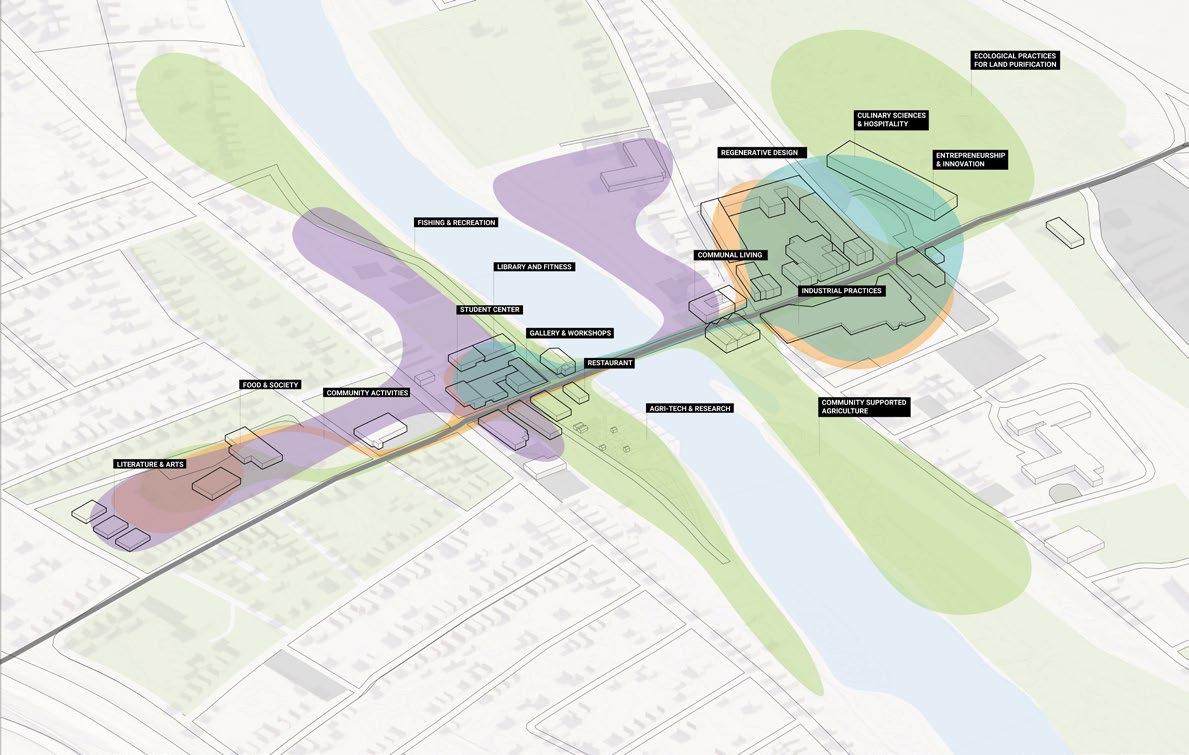

FOOD & SOCIETY ENTREPRENEURSHIP & INNOVATION REGENERATIVE ART & DESIGN COMMUNAL FACILITIES


05 9:00 AM 1. THE STUDENT CENTER 10:00 AM 2. AGRICULTURAL FIELD STUDENT ROUTE MADELINE, AGE 20 RESTORE RECONNECT
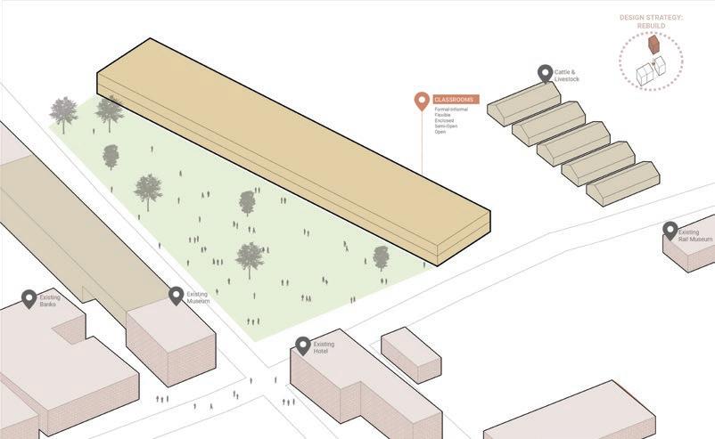

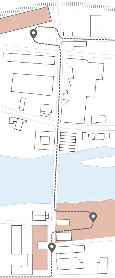
1:00 PM 3. CLASSES IN MAJOR REPROGRAM REBUILD 1. 2. 3.
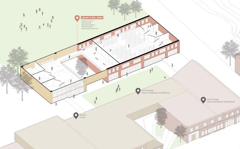
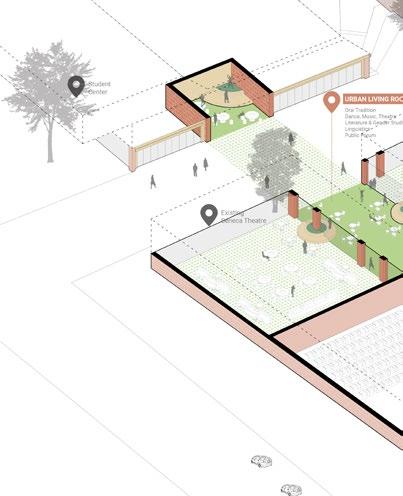

07 2:00 PM 1. LIBRARY & WELL-BEING 4:00 PM 2. URBAN LIVING ROOM ELDERLY ROUTE JOSH, AGE 64 RESTORE RECONNECT
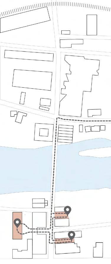
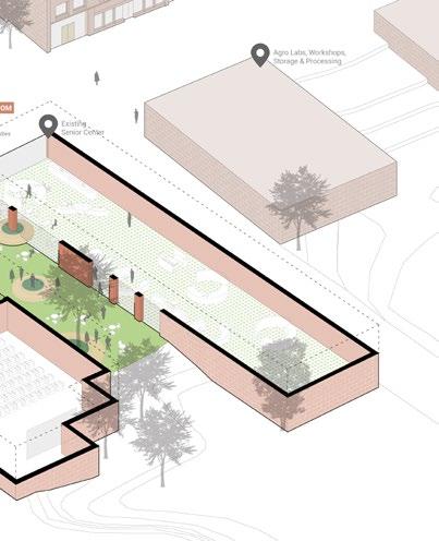
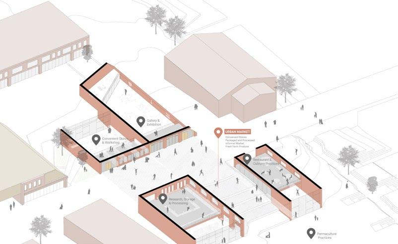
5:00 PM 3. URBAN MARKET REPROGRAM 1. 2. 3. REBUILD
09
11
When working in cohesion, the campus would serve as a dynamic
space fostering dialogue, movement, and capital within the city !
PROJECT DETAILS
Individual Academic Work Undergraduate Thesis Project Spring 2018
Guided by Professor Sameer Deshkar
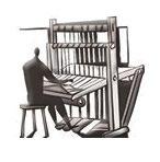
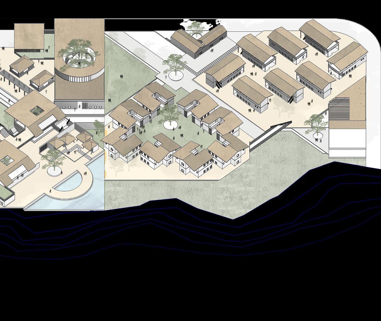
INDIGENOUS OCCUPATIONS
CENTER FOR SKILL DEVELOPMENT EAST MELGHAT, MAHARASHTRA, INDIA
Can the ‘Skill India Initiative’ be more than a proposal extended into physical reality ? Can environments be designed so as to benefit distressed individuals at grass-root level ?
Human resource up-gradation is the essence of development of any country. On one hand where we are persistently working to improve our urban environment, villages are facing a trivial problem of development. One of the many important aspects is imparting skills to the rural youth and women. In order to ensure growth of the village community, the Government launched another program after ‘Digital India’ and ‘Make in India‘ to leverage our demographic dividend more substantially and meaningfully. Launched in March 2015, it is called the ‘Skill India’ program. My contribution to the above would be the creation of an experience based design for holistic learning and skill development that would pave way for an equally skilled rural-urban society.
13 02
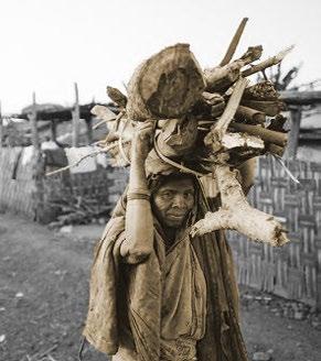
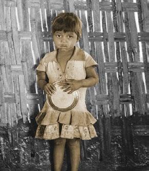
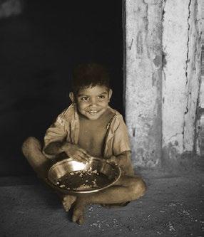
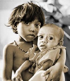
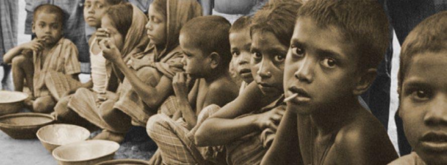
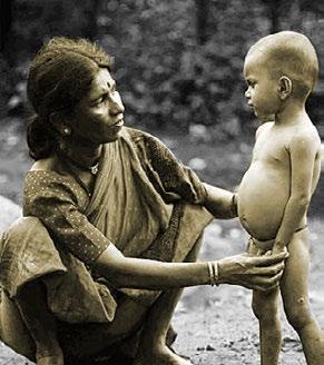
MALNUTRITION INADEQUATE CHILDCARE ILLITERACY EXTREME POVERTY DISMAL HYGIENESUBSTANDARD HOUSING IMAGES : PLIGHT OF DWELLERS IN A TRIBAL VILLAGE OF THE MELGHAT FOREST DIVISION
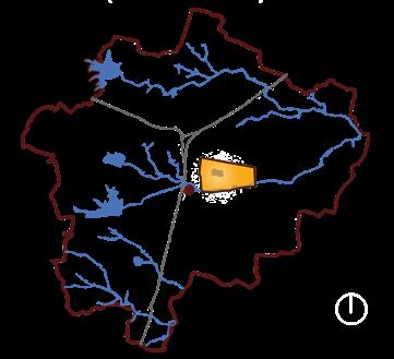
Melghat has a history of endemic malnutrition and of being a perpetually famine affected region where every year hundreds of children die of starvation. With the forests being declared as reserves, this problem is more acute in tribal areas where a majority of inhabitants are struggling for basic livelihood opportunities. Provision of only monetary support or relief materials, as is happening in the current scenario, would in no way mitigate this quandary. The only solution of restoration is by creation of sustainable and self-sufficient village economies. This would facilitate rural upliftment and improvement in living conditions, provision of alternative livelihood opportunities to the tribals as well as revival of their traditional occupations which have been lost over the generations.
WHY?
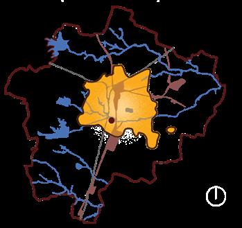
LOCATING RELEVANT
Retreat and Plantation

Public Rest House
Health Training Center
Public Bust Stop
Weekly Market
Village Entry
Industrial Training Institute
Block Development Office
ADJACENT AFFECTED REGIONS
1. Sipna
2. West Melghat
3. Buldhana
4. Akola
5. Gugamal
SCOPE OF IMPACT CREATION
1. Wider reachability
to maximum affected villages.
2. Lack of development in the region : No big industries in this region to generate employment opportunities.
3. Scope for promoting vocational education among tourists : Being the only hill station in Vidarbha region.
WHAT? HOW? IGNORANCE OF THE MAJORITY IRRELEVANCE OF IMPARTED EDUCATION MASS EXODUS FROM VILLAGES TO CITIES UNFULFILLED SUPPLY AND DEMAND NEEDS URBAN 31% RURAL 69% YOUTH RURAL SKILLED WHY?
: Proximity
1. 2. 3. 4. 5. 6. 7. 8.
SITE PROPOSED SITE IDENTIFIED NEEDS OF THE PEOPLE and PLACE WHERE? WHERE? WHAT? HOW? SUPPLY DEMAND
50 km100 km200 km 5. 2. 3.4. 1. 10MINWALKINGRADIUS 5SUIDARGNIKLAWNIM 1.
2.
3.
4.
5.
6.
7.
8.
HOSPITALITY
OF SETUP
OF


FOOD PROCESSING SECTOR

SUSTAINABLE PRACTICES
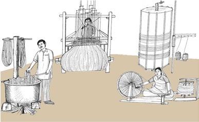
15 WHY? WHERE? HOW? ALTERNATIVE SOURCES OF LIVELIHOOD RELEVANT TO THE CONTEXT AND OF SIGNIFICANCE TO THE PAST WHAT? ACTIVITY AND SPACE ANALYSIS CULTURAL SECTOR Promoting culture of the region among visitors TEXTILE SECTOR Cotton growing belt in the context
SECTOR Training to cater to the adjoining tourism industry HANDICRAFT SECTOR Traditional craft of the Korku Community
To ensure self-sufficiency and additional income
Availability of raw materials for preparing allied productsallied YARN MAKING WEAVING PRINTING 2. WEAVING AND KNITTING 4. EMBROIDERY AND STITCHING 1. GINNING AND SPINNING TEXTILE SECTOR DURATION DAYS To apply the concept of flexibility of spaces To decide upon temporality of space To work upon space configuration TEACHING BUILTWEEKS MATERIALS SEMIMONTHS MACHINERY OPEN LEVEL
TYPE
SETUP Workshops, pavilions Classrooms, workshops Labs, workshops, pavilions Classrooms, workshops SPACES 3. DYEING AND PRINTING 1. Warp is prepared by the warper into a length of 63 yards. 2. Warp yarn is then dyed. 3. Plain cotton yarn is transferred into bobbins for the shuttle. 4. Yarn is woven into fabric. 1. Warp for the loom is made. 2. Warp yarn is starched. 3. Weft yarn is rolled onto a bobbin. 4. Fabric is created on the loom. 1. Patterns are wax printed onto the fabric. 2. Wax printed fabric is dyed in cold water. 3. Dyed fabric is washed in boiling water to melt the wax. 4. Patterns are revealed. 4. 4. 4. 1. 1. 1. 3. An understanding of the processes from Khamir Craft Resource Center, Bhuj, Gujarat, India. Observations from the study done for the 6 courses to decide upon the various space typologies and requirements. Similar tabulation has been done for the other 5 courses. 3. 3. 2. 2. 2. Understanding vocational courses and their requirements; Selection criteria : 1. Availability of raw materials in the context for further learning / processing. 3. Relevance in the neighboring context and beneficial to the user group. 2. Relevance in promoting awareness and self-help / home-grown industries. 4. Relevance in promoting learning and quality of life at the center.


HOW?WHY? WHERE? WHAT? LEARNING FROM EXPERTS LEARNING FROM PEERS Spaces for story-telling; Organized Space Typology Spaces for interaction; Interactive Space Typology LEARNING BY YOURSELF LEARNING BY DOING Spaces for reflection; Individualistic Space Typology Spaces for testing; Experimental Space Typology INTENDED TYPOLOGY OF SPACES UNDERSTANDING PATTERNS OF IMPARTING AND OBTAINING EDUCATION Maintaining a constant height of while observing change in widths from 3.00m to 4.50m to 6.00m. Variations in enclosed volumes and corresponding movement of people within, giving rise to corridor, pausal and prolonged spaces. The idea is to draw attention on what’s not built by defining connections between functional spaces and how people navigate across these spaces, thereby embodying their values and hopes in the very fabric of its making ! Design Objectives : 1. An architectural setting for a non-conventional learning environment 2. Flexibility in design via creation of multi-functional spaces PROLONGED To sustain longer interaction PAUSAL SPACE Interaction for a smaller period of time CORRIDOR Fast Movement CONSTANT HEIGHT = 3.00m CONSTANT WIDTH = 3.00m CONSTANT WIDTH = 4.50m CONSTANT WIDTH = 6.00m CONSTANT HEIGHT = 4.50m CONSTANT HEIGHT = 6.00m 1 : 1 2 : 3 1 : 2 3 : 2 1 : 1 3 : 4 2 : 1 4 : 3 1 : 1


17 LEARNING COMMUNITIES AROUND INFORMAL OPEN SPACES DISPARATE PHYSICAL AND VISUAL AXES TO CREATE INTEREST DRAWING ATTENTION ON WHAT’S NOT BUILT SERVICE ENTRY 0.00 m WAY TO STUDENT ZONE WAYTOPUBLICZONE MAINROAD SERVICE ENTRY 0.00 m to -1.50 m ENTRANCE PLAZA (PUBLIC ZONE) 0.00 m ENTRANCE PLAZA (STUDENT ZONE) -1.50 m ACADEMIC BLOCK -1.00 m CANTEEN -1.00 m FOOD PROCESSING SECTOR -1.00 m HOSPITALITY SECTOR -1.00 m HOSPITALITY SECTOR -4.00 m HANDICRAFT SECTOR -4.00 m CENTRAL COURT -3.00 m FOOD PROCESSING SECTOR -4.00 m TEXTILE SECTOR +0.50 m TEXTILE SECTOR -2.50 m PAVILION -1.50 m WORK STATIONS -1.00 m PAVILION +0.50 m OVER-BRIDGE 0.00 m ENTRY FROM RESIDENTIAL UNIT -1.50 m GUEST HOUSE +0.50 m ADMIN +0.50 m VIEWING PLAZA +1.00 m LEARNING CENTRE +0.50 m CULTURAL SECTOR +0.50 m AUDITORIUM +0.50 m to -4.00 m AUDITORIUM +0.50 m to -4.00 m COURT -4.50 m EXHIBITION PAVILION -4.00 m VISITOR PARKING 0.00 m STUDENT PARKING 0.00 m SERVICES +0.50 m CRECHE +0.50 m GREEN SPACES SEMI - OPEN SPACES WATER BODIES KEY PLAN -3.00 m & -4.50 m PLAN 0.00 m & -1.50 m 0 10 20 50
ENHANCED
HIERARCHY
CONFIGURATION OF

A VARIETY OF SCALES
USE OF SITE CONTOURS TO CREATE INTEREST
IN SPACES TO CREATE SPATIAL NARRATIVES
TRANSITION SPACES AT
All of us do not have equal talent, but ... All of us should have a fair opportunity to develop our talents. – Dr.
APJ Abdul Kalam
“ “ INTERLOCKING ROOF SHINGLES BRICKWORK WITH LIME AND MUD PLASTER BRICK JAALI WALL PERMEABLE PAVERS


19


PROJECT DETAILS
Academic Work
2.50 week, fast-paced studio
Fall 2021
Guided by Professor Jeremy Foster
Team Members: Klytaimnistra Avgetidou
Shhrruti Jain Somin Lee Xingyao Wang
My contribution: Research, analysis & design logic
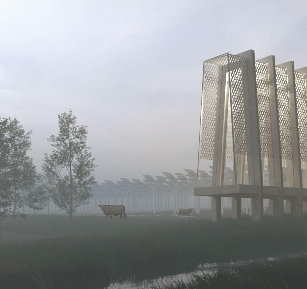
ARCHITECTURE & DISCOURSE STUDIO, CORNELL UNIVERSITY FINGERLAKES REGION, NY
How can material atmospheric analysis and design address the relationship between the past, present and future landscapes of a region?
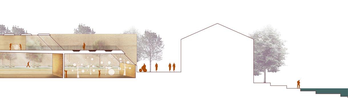
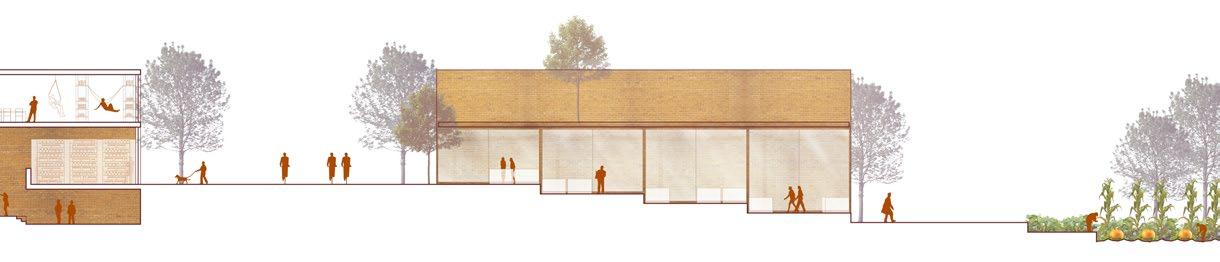
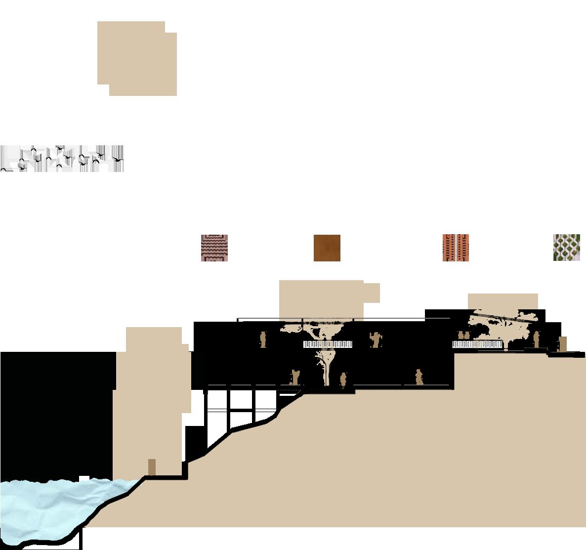
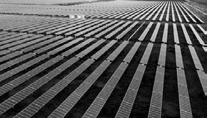
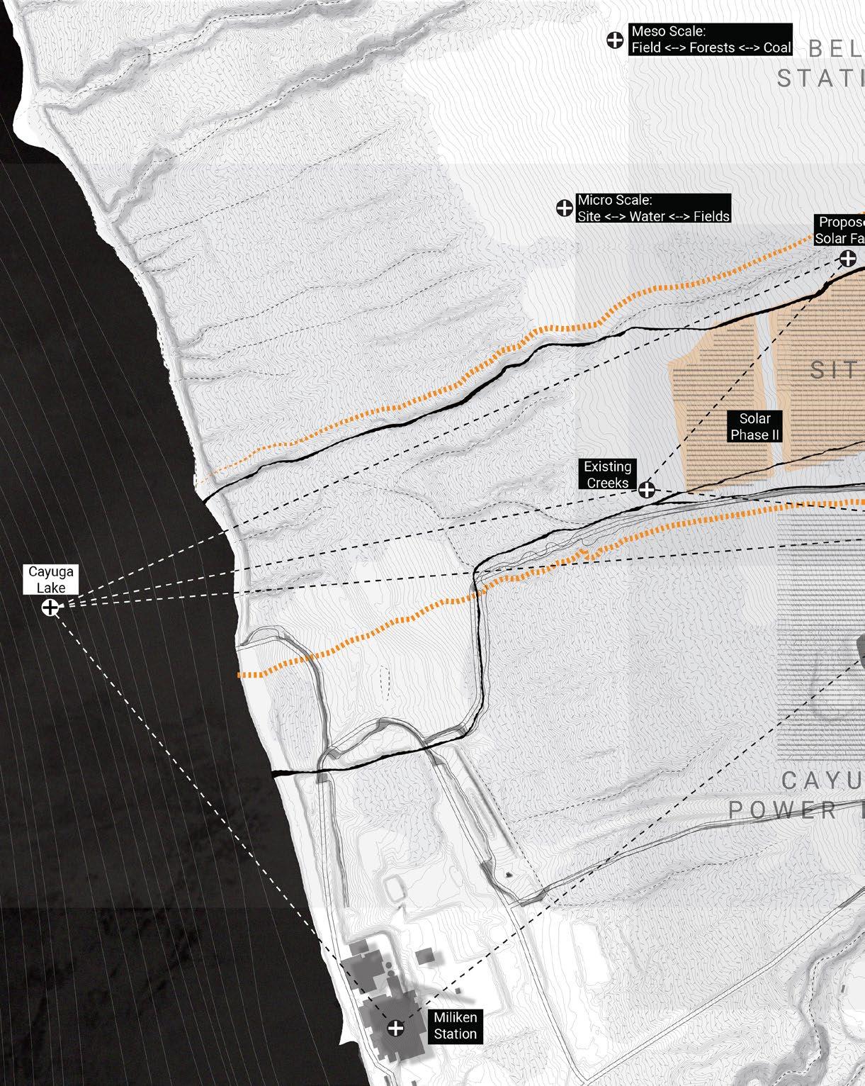
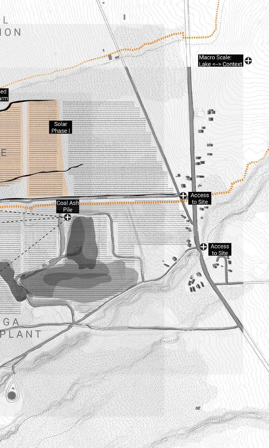
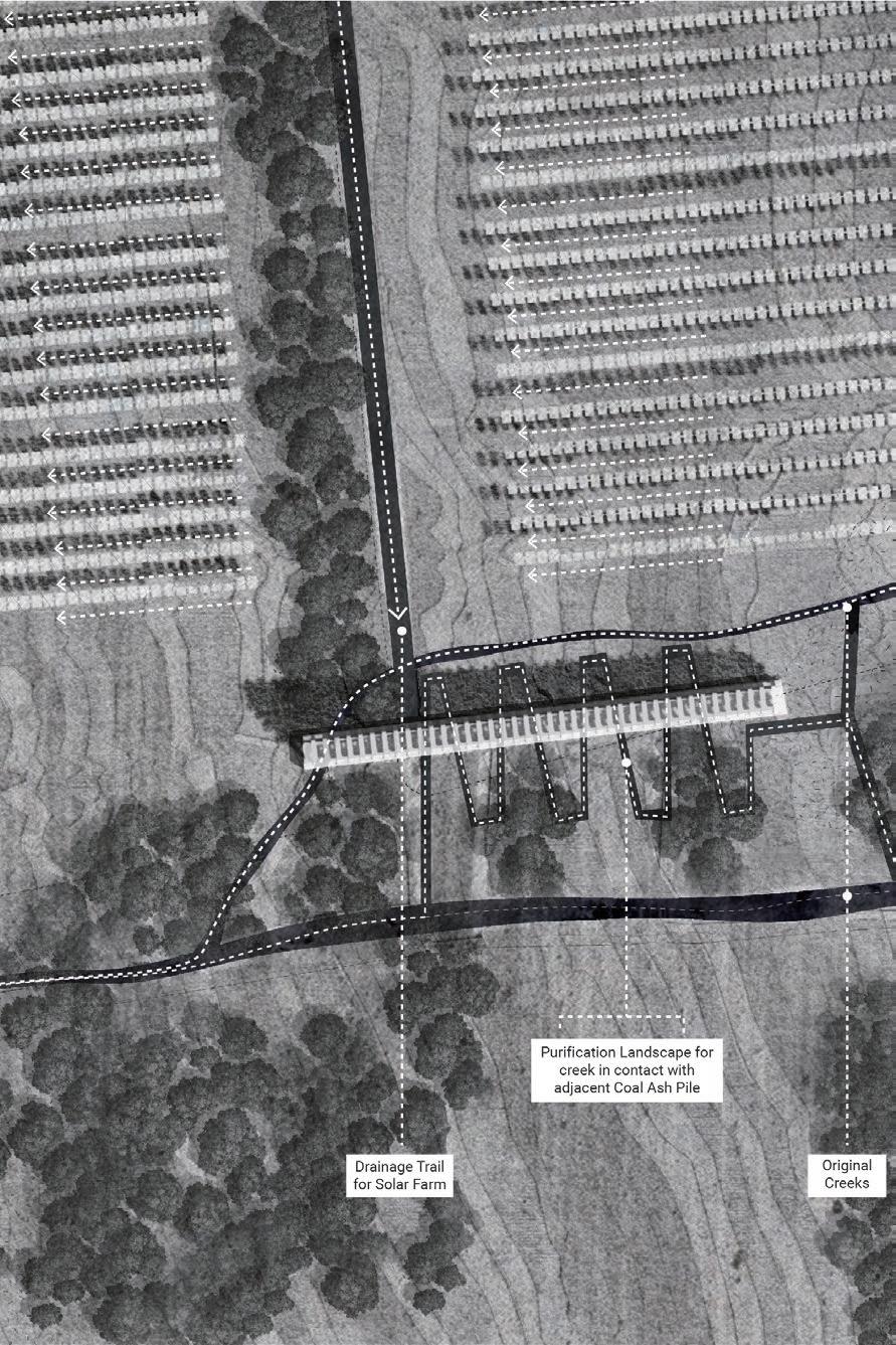
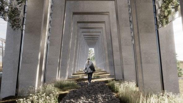
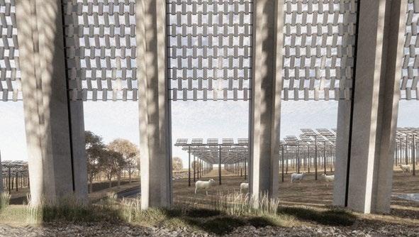
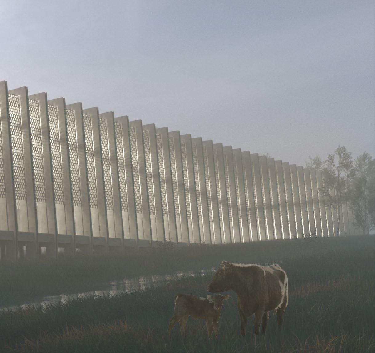
In the turn of the 21st century, there is a re-visioning of the long-forgotten landscape of the Finger Lakes region. The Bell Station site resides in this region and facilitates severe operationalization of the rural landscape to support urbanization. Project ‘ReIncarnation’ focuses on the intangible aspect of weaving through the past, present and future landscapes of the region. A thorough scrutiny leads us to 3 parameters that play a crucial role in determining the evolving landscape of the region; A resultant of past actions, ie. the coal-ash pile, the present-day hydrology on site, ie, the water creeks and the evolving suture identity of the region, ie, the solar farm. This time consciousness in the Re-Incarnation project focuses on the possibility of turning back the ecological clock of the region, presently disturbed by human action. The idea is to develop a culturally sensitive model that influences how we think about the environment and most importantly highlights the notion of a site guiding its design!
21 03 RE-INCARNATION
RESULTANT
EVOLVING FUTURE IDENTITIY: THE SOLAR FARM
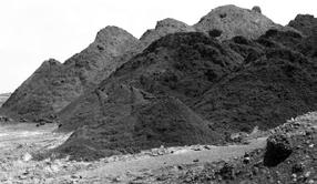
Our site resides in proximity to a coal power station. Over a period of 64 years, an enormous amount of residue generated as a by-product of coal combustion led to the formation of 38 acres of coal-ash landfill on the 472-acre site. Re-Incarnation focuses on minimizing the ecological impacts of the landfill.
Site comprises 3 water creeks discharging into the lake. Owing to its proximity to the coal-ash pile, one creek is severely contaminated. However, a potentially tidy creek merges with the contaminated one on the site. Siting the intervention at this critical junction becomes an important design consideration.
Even the most optimistic scenarios for the site’s future include extensive solar farms that capitalize on existing high-power lines. The intervention focuses on mitigating the harmful impacts of the solar farm.
Micro analysis of site to guage its potentials and threats.
OF PAST ACTIONS: THE COAL-ASH PILE PRESENT-DAY HYDROLOGY: THE WATER CREEKS
23
The image showcases relationships at various scales; macro, meso and micro on the site. The various elements comprise the Cayuga Lake, the Bell Station context to the north, the Power Plant to the south, as well as the fields, forests and farms that constitute the local landscape of the region. Additionally, the 3 key parameters that play a crucial role in determining the evolving landscape of the region have also been marked. These are the CoalAsh Pile, the Water Creeks as well as the Solar Farm.
Extensive use of materials available on site such that the construction process reduces the ecological contamination by the coal-ash pile. The major building material is therefore made out of fly-ash which is a major constituent of coal-ash.


Addressing the 3 ecological consequences; the ongoing coalash pile formation, the water creek contamination and the incoming solar farm escalation, the project locates itself at the center of the conjunction for ecological compensation, playing the role of a purification and a drainage system as well as a site for ecological awareness generation. Such an allencompassing location gives rise to an anthropogenic and planthropogenic landscape.
25
COAL-ASH PILE
DRY CORN STALK
FERTILIZERSOIL WOOD FLY-ASH CHIPS
When experiencing the
systems
with layers of soil, the mechanism of water

process and the coming and going of natural life cycles.
hidden under the ground, in the water and within the forest.
structure, one is revealed
purification
These
were previously
FLY-ASH
CONCRETE FLY-ASH
BRICK
EVOLUTION OF KEY
MATERIALS
OVER TIME
“Re-incarnation” is meant to give a new form to the contaminated water of the creek and re-purpose the otherwise hazardous coal-ash pile. The installment of a purification and drainage system at one of the creeks won’t be able to solve on their own the problems of the incoming solar farm as well as the severe contamination by the power plant and its coal ash pile. However, there is a belief that such a proposal will raise an issue and potentially enable the adoption of similar systems in the context, contributing to the gradual ecological compensation and revitalization of the region.
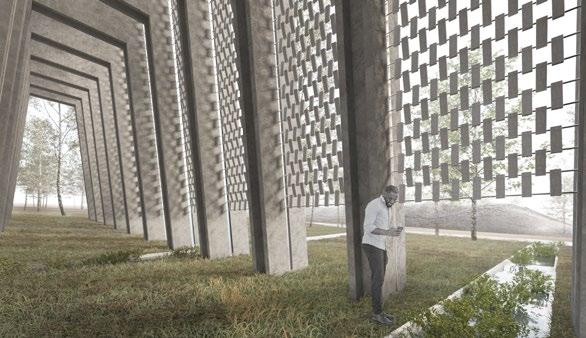
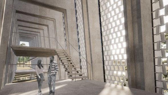
27 REFLECTIVE PLATFORM... spaces for reflection & environmental awarenessPERMEABLE LANDSCAPE... exposing oneself to the purification process
WINDOW TO ANTHROPOCENE... a cycling tussle between humans & naturePRECARIOUS INTERIOR... a material juxtaposition between softness & hardness
Shhrruti

Eesha Ithadi
Vaishnavi
Kewal

Mohit
CENTER FOR HUMAN INTERACTION, G-SEN COMPETITION (NASA) NAGPUR, MAHARASHTRA, INDIA
With the recent political climate fostering developmental growth, the declaration of the Smart Cities Mission was only expected. For the select few, the phrase has conjured up a rush of wild imagination particularly, among the hungry (for power) and thirsty (for liquid cash). At the bottom of the pyramid, if ideas do percolate to the base, there would be the eternal promise of employment and therefore the hope of satisfying the hungry (for food) and the thirsty (for water). For this competition, we were asked to design a Center for Human Interaction. The typology of the emergent space was not defined and the contestants were free to choose functions of their
which define ‘smartness’. The campus was intended to be a reflection of the various layers of the city as well as an incubator of new systems of social outreach defining out-of-the-box solutions.

29 04 ARCHITECTURE OF ECONOMIC PRESSURE
choice
PROJECT DETAILS Competition Entry Special Mention (2nd) Spring 2016 Team Members (In alphabetical order) : Research, Analysis and Documentation : – Pratibha Patil –
Jain – Tejaswini Deshmukh Design : – Ankita Bawankar –
–
Farkase Presentation and Graphics : – Ankita Khante –
Rewatkar –
Yadav – Shivangi Negi RESEARCH CHALLENGE DESIGN CHALLENGE DESIGN PROPOSAL PUBLIC MARKETS CITIZEN ENGAGEMENT GOOD GOVERNANCE ICT FUNCTION DEFINING SMARTNESS SOCIAL INTERACTION USER PROFILE CENTRE FOR HUMAN INTERACTION CITY EVOLUTION COMPARATIVE ANALYSIS IDENTIFY SMART IN NAGPUR INNOVATION MAINTAINING ESSENCE REJUVENATING THE EXISTING SOLUTION TO CHALLENGES SELF-SUSTAINABLE SMART CITY ANALYSIS STUDY OF NAGPUR ADAPTABILITY USER OUTFIT DESIGN PROPOSAL SCOPE – Integrating all economies. – Building local economy. – Developing market as effective public spaces. GOAL Design to disparage disparity VISION Redeveloping the Informal Sector RESEARCH AND DESIGN METHODOLOGY Can a typology be a reflection of various layers of the city ? Can it inform its citizens and visitors about the city ?
City is an
It is a system of

elements. It therefore becomes almost impossible
with the highly branded and somewhat faddish nature of the
Taking
SMART ECONOMY
SMART GOVERNANCE
SMART LIVING
EVIDENCE BASED DESIGN
based on groundless approaches, improper execution and most
concerned with a given space.
This
by
6-AXES APPROACH DEFINING SMART SMART PEOPLE

SMART MOBILITY
SMART ENVIRONMENT
Dr. Smita Khan l Architect and Professor City is an organism in itself, it needs to breathe, grow and work to sustain in this environment. With the enormous havoc of global warming, how will a city breathe and be alive? Selfsustainability is a major challenge for smart cities.
Ankita Deshmukh l Engineer
Economic development should be the highest priority. The gap between the rich and the poor is widening with times. The unprivileged section of the society should not be ignored in the city’s development.

Pankaj Shah l Nagpur Urban Planning Department

Citizen’s engagement should be given the highest priority in smart city planning over information and technology driven development.

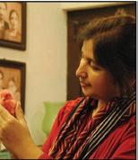
Interview by Pratibha Patil and Shhrruti Jain. For details about Nagpur Municipal Corporation’s Smart
www.nmcnagpur.org.in.
organism in itself, that needs to breath, grow and work to sustain in this very environment.
multiple
to capture the nuances of every city and its multiplicity within a one catch-all formula. One of the chief limitations
smart city solution is that most formulations involve a recipe, formula or template for success or progress,
importantly vested interests. Area-based approach should thus be adapted after critical examination of issues
into consideration the fuzzy nature of the smart city definition, we have attempted to summarize the characteristics of a smart city.
has been achieved
literature reviews as well as evidence-based approaches to find out what do we really mean by ‘smart’. PLANNING FUTURE CITIES : ONE SIZE DOES NOT FIT ALL
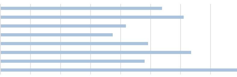
The aim of this survey is to understand how much you know about the SMART CITY concept and what do you think about YOUR CITY being a smart city. This would help us in understanding and designing a typology that the citizens really require. WE ARE GETTING SMARTER, IS OUR CITY TOO ? WHICH OF THE FOLLOWING DO YOU THINK ARE REQUIRED TO BECOME SMART? WHAT ARE THE BIGGEST CHALLENGES FOR YOUR CITY TO BECOME A SMART CITY? IN WHICH SECTOR ACCORDING TO YOU IS THERE A NEED FOR INTERACTION? ACCORDING TO YOU, “SMART” IN SMART CITY INDICATES? 18% Recreational 33% Commercial 20% Institutional 20% Residential 8% Travel 3% Other 68% Increasing quality of life 32% Technological Development 18% Traffic 14% Pollution 17% Drainage 13% Crowding 5% Other 13% Interaction 9% Power 10% Housing Poll created by Ankita Khante on December 16, 2015. POLL.FBAPP.IO
City Initiatives and to give suggestions, log onto
19% Interaction 15% Economy 17% Transport 14% Energy 14% IT 7% Culture 12% Education
CONNECTING THE INTERACTIVE SPACES OF EACH ERA
SOCIAL INTEGRATION
The city’s centered location makes it receptible to people from different classes of society, coming from various backgrounds, all residing with peace and mutual understanding.


CLEAN AND GREEN NAGPUR DEFENSE
Sustainability has been imbibed in the psychology of the


with people inclined
that Nagpur had inherited, it clinched its place
Maintaining the green
the greenest cities in
India is one of the largest Ordinance Factories creating
31
general masses,
towards green culture.
cover
amongst
India.
MAHAL OLD CITY CENTRE MOMINPURA RESIDENTIAL AND COMMERCIAL NEIGHBORHOOD OUR CITY NAGPUR; EVOLUTION AND MORPHOGENESIS Proposed Town planning of Nagpur by ‘Chand Sultan’. Moved capital from Deogarh to Nagpur. Constructed Kila Palace which became central core, later called ‘MAHAL’. — Gond King ‘Bhakt Buland Shah’ founded Nagpur by joining 12 villages on the banks of river Nag. Chand Sultan’s death. Disputes regarding succession arose and Raghuji Bhonsale helped to restore the elder son to the throne. Raghuji Bhonsale intervened again. Nagpur became the capital of the Bhonsale dynasty. — Central Province was formed capital, making it a logistic hub. — Great Indian Peninsula (GIP) between Bombay and Nagpur.
Raghuji
III Bhonsale died without an heir. Nagpur Municipal Community got — Sitabuldi fort Delhi, Madras and — Its equal proximity — Cotton supply Bhonsale / Sitabuldi fort was built. Came under British rule (Lord Dalhousie). 1706 1702 1739 1743 1817 1760 1853 1853-61 1864 1870 GONDS (1702 - 1750) BHONSALES (1750 - 1850) SITE LOCATION OUTER BOUNDARY EXPANSION LINES WATER RESERVES TAPPING THE POTENTIALS
junction connected Nagpur with Bombay, and Calcutta. proximity made it an administrative center.
from Vidarbha = Country’s 1st textile mill.
Municipal established.
formed and Nagpur became the hub.
GIP) : Railway’s new route Nagpur.
— Nagpur became capital of Central Province and Berar.
— Establishment of Nagpur Improvement Trust (NIT).
— Sir Patrick Geddes prepared a plan for Nagpur Garden City.
First civil expansion by NIT. Nagpur served as a regional economic center in central India.
Dalit to Buddhism conversion took place at Dikshabhoomi.
— Western Coalfield Limited established.

MIDC established (HowarhMumbai National Highway, Nagpur-Hingna road).
Presence of mineral ores.
— Butibori MIDC established.
Six 5 star industrial estates, one of the largest industrial areas in Asia. (Triggered development in the next two decades).
VIDARBHA CRICKET ASSOCIATION STADIUM
LARGEST CRICKET STADIUM IN INDIA
— Nagpur Improvement Trust (NIT) resolution.
Khaparkheda thermal power plant established.
— Central Province and Berar town planning act and regulation of uses of land act implemented.
— Indian Army ordinance factory established.
— MIDC and MRTP Act (1992) increasing development.
— Coal India.
— Sitabuildi Fort : Headquarter of Indian army and Airforce.
Introduction of Metro in Nagpur city.
— MIHAN project undertaken by GoM (4354 hectares).
— Real estate developers, MRO unit by Boeing worth 100 million, 63 acres business park development proposal.
— Integrated Road Development leading to efficient TOD.
largest importers of defense equipments with Nagpur serving as a hub for 3 creating potential for manufacturing of several items of defense
DEEKSHA BHOOMI
MONUMENT OF SOCIAL REVOLUTION
EDU-CITY
Owing to its strategic central location in the country, Nagpur fast emerged as an education hub with 7 national colleges, largest regional university and several potential private institutes.
FUTALA LAKE REVIVAL OF CITY’S LOST WATER BODY
GLOBAL INTERCONNECTEDNESS
Nagpur holds a special place on the global map owing to the establishment of Maharashtra Industrial Development Corporation (MIDC), MIHAN and Special Economic Zones (SEZs).
20001903 1928 1948 20121950 1966 1964 1937 1956 1992 19621939 COLONIAL (1850 - 1947) POST INDEPENDENCE (1947 - 2000) MODERN (2000 - ) RESERVES RAILWAY LINE
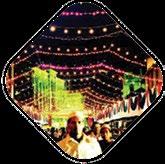
It is a constant belief that exciting things happen when a variety of over lapping activities designed for all people meet in a flexible environment, opening up possibilities of interaction outside the confines of institutional limits. When this takes place, depressed areas become dynamic places for those who live, work, and visit. One of the most obvious, but perhaps least understood methods of enhancing social integration in public spaces and encouraging upward mobility are thus the public markets.
WHY MARKET?
An attempt to connect the society, once again in a commercially viable setup !
HUMAN INTERACTION
INTELLECTUAL INTERACTION PHYSICAL INTERACTION VISUAL INTERACTION

Public
Markets
Public markets create a vehicle of upward mobility and individual empowerment for lowincome people.

Public markets are viewed as a more important component of a broader civic agenda.
Serves as a catalyst for interaction.


Activity attracts people, old and young, the blue
white collar, the local inhabitant and the visitors alike. Public markets sustain their operations with minimal subsidy.
Activity itself reflects the essence of the city.
EYES ON THE STREET
The hustling markets help in ensuring vigilance and safety.

One of the most costeffective investment cities can make is to form focal points for linking rural and urban economies.

33 CAPTURING THE ESSENCE OF PUBLIC MARKETS ENFORCED INTERACTIONINCLUSIVE PUBLIC SPACES PLURALITY IN SPACESHIERARCHY OF SPACES SOCIO-ECONOMIC INTERVENTIONS PREMIUM MODERATE VENDOR INTEGRATING ALL ECONOMIES TYPES OF SETUPS EQUITY IN PLANNING ACTIVITY SCHEDULING JAN SUN 0000 hrs 0600 hrs 1200 hrs 2400 hrs1800 hrs ACTIVE FADING TUE FRIMON THUWED SAT MAY SEPTMAR JUL NOVFEB JUN OCTAPR AUG DEC FESTIVAL FLEA REGULAR MONTHLY FESTIVALS AND FLEAS WEEKLY AWARENESS PROGRAMS DAILY DAY AND NIGHT USE MODERATE VENDOR PREMIUM CONVENTIONAL MARKET OUR MARKET P P M M V V V M UNEMPLOYED WHITE COLLAR BLUE COLLAR
markets enhance the potential for social integration in public spaces. SOCIAL INTEGRATION UPWARD MOBILITY TRIANGULATION BRIDGING GAPS TARGETING THE INFORMAL SECTOR COMMUNITY BENEFITS SUSTAINABLE APPROACH INCLUSIVE ENVELOPE SPEAK ABOUT THE CITY
create targeted impact on the informal layer of economy.
and
PROPOSING DESIGN INTERVENTIONS IN THE CITY’S CENTER


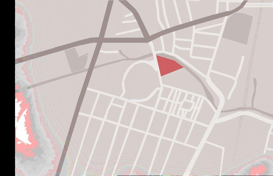
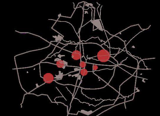
NODAL INTERACTIONACTIVITY SCHEDULING STREETSCAPING FRACTAL ALGORITHM PAN - CITY INTERVENTIONS SADAR DHARAMPETH JAITALA OUTER RING ROAD DHANTOLI BULDI MAHAL SITE MUNJECHOWKAMBAZARIROAD CHANDRAPURNAGPUR ROAD ABHYANKAR MARG YASHWANTRAO CHAVAN STADIUM DHANTOLI POLICE STATION NAGRIVERCANAL GOVERNMENT TECHNICAL SCHOOL HOTEL HARDEO MOKSH DHAM The site forms a part of major commercial area, Dhantoli, The Central Business District of Nagpur. 1. Enhanced approachability 2. Presence of multi - dimensional strata CENTRAL BUSINESS DISTRICTPOTENTIAL REALIZED
A sensitive approach is required to rejuvenate the chosen inactive areas such that they become pleasant spaces that respond to their context and add to the spirit of the city. MODULE DESIGN FOLDABLE DESIGN MIXED USE l DAY TIME - VENDORS l NIGHT TIME - EATERIES MIXED USE l DAY TIME - DISPLAY AND EATING AREAS l NIGHT TIME - SHELTER RETRACTABLE ROOFING LOCKABLE AT NIGHT SOLAR PANELS ORGANIC GARBAGE CONVERTED INTO BIOGAS FUEL FOR COOKING
35 MULTIPLE ACCESS POINTS STEPPED ENTRANCE PLAZA MARKET STREETS MARKET MODULES MAJOR INTERACTIVE NODE
NODAL INTERACTION ACTIVITY JOGGING TRACK PATTERNED LANDSCAPE CHILDREN’S PLAY AREA SALVAGE HARDSCAPE ELEMENTS TENSILE STRUCTURES VIPANA ARCHITECTURE OF ECONOMIC PRESSURE SCHEMATIC VIEW OF THE PROPOSED DESIGN SOLUTION
BRICK
UNIVERSITY OF WESTMINSTER, HANDS-ON URBAN DESIGN COMPETITION NAGPUR, MAHARASHTRA, INDIA

Can we achieve a design that bridges the gap between abled and differently-abled individuals, a design that is rooted in human values ?
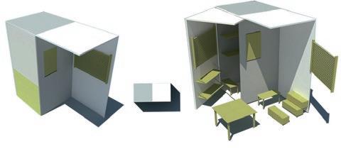
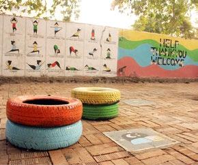
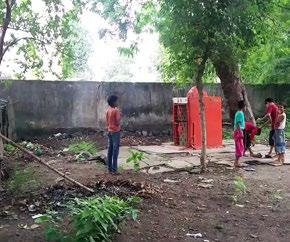
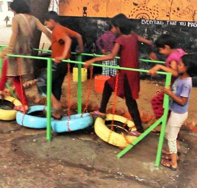
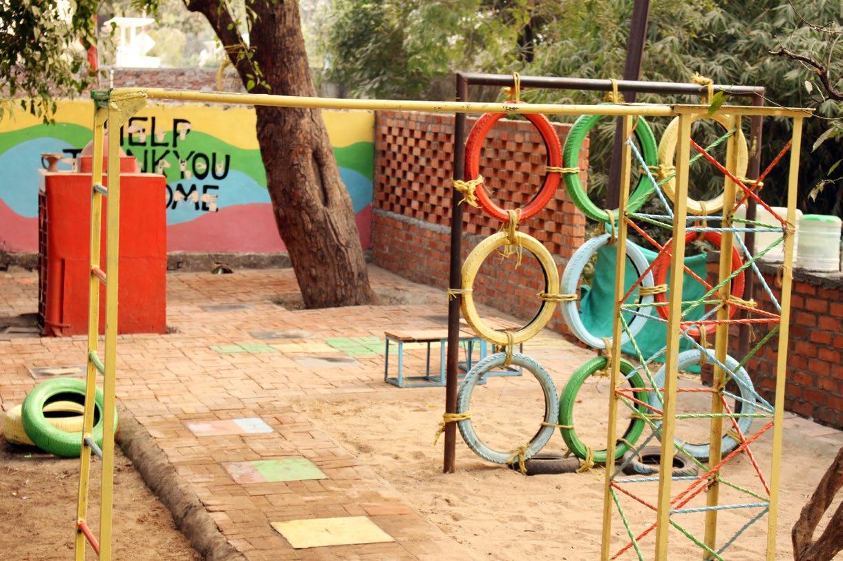
The project was part of an international design competition organized by the University of Westminster and National Association of Students of Architecture (NASA) under the ‘Clean India’ and ‘Massive Small’ campaigns for reviving public spaces in our cities. As the various regions in our city—Nagpur grew at macro level, certain sites at micro level were left neglected. Located in a busy residential and commercial region, one such space was a highly disused school pocket and community space of the past. Realizing how meager access children of the Deaf and Dumb Residential School and that of the adjacent community had to play areas, we chose this 13m X 25m pocket as our site, with a resolution to provide a common ground for the abled and the differently-abled.
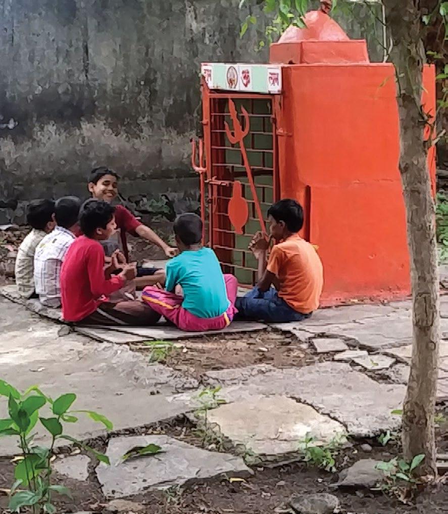
37 05
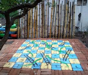
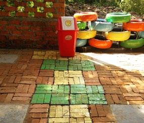
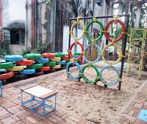
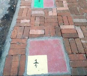
BY BRICK ... bringing individuals together
PROJECT DETAILS Competition Entry Citation (1st) Fall 2016 - Spring 2017 Team Members (In alphabetical order) : Aakanksha Chandak Abhay Agarwal Anurag Rathi Shhrruti Jain Tejaswini Deshmikh CHILDREN OF THE DEAF AND DUMB RESIDENTIAL SCHOOL DURING OUR 1st VISIT TO THE SITEFOR PROJECT VIDEO
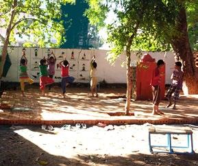
CREATIVE ZONE
Differently-abled kids are blessed with greater creative skills. However, the education system these days is very rigid. Therefore, this zone permits exploration of creativity!
EXPLORATION ZONE
Strategic location of the temple creates a peaceful atmosphere. However, the existing site condition did not permit effective usage. Thus, a zone for all age groups, promoting fitness and health!
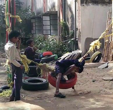
PLAY ZONE
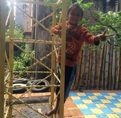
The neighborhood children had meager access to play areas. Hence, a zone consisting of slides facilitating interactive learning for the children!
KIDS OF DEAF AND DUMB RESIDENTIAL SCHOOL

VULNERABLE OVER-LOOKED COMMUNITIES

POTENTIALS
GREEN ZONE
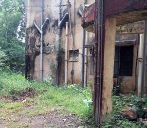
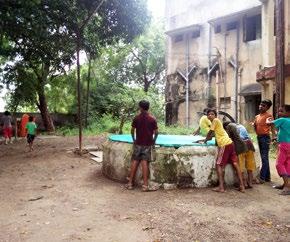
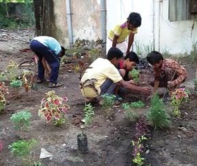
An unsafe zone due to the presence of a water tank in a dilapidated condition transformed into a green zone, restricting entry. Thus, a zone created via community participation, inducing a sense of belonging!
Lack
CONTEXT
STRATEGIC LOCATION ALLOWS PARENT VIGILANCE

WILLINGNESS OF AUTHORITIES TO PERMIT US TO WORK
VISION
Breaking the barrier between the abled and differently-abled

AIM

A
GREEN ZONE
the
design
community
integration of recycled
FAVORABLE SETTING CREATED BY EXISTING TREES


CATALYST FOR LARGER COMMUNITY PROCESSES


CONCEPT
An inclusive space, primarily for children of the Deaf and Dumb Residential School
recreational learning.
REALIZEDUSER GROUPS
robust
created via
participation and
materials.
of recreational spaces and indifferent public attitude towards
differently-abled.
facilitating
BEFORE - LACK OF MAINTENANCE AFTER - EXPLORATION OF CREATIVITY BEFORE - UNHYGIENIC CONDITIONS AFTER - FACILITATION OF INTERACTIVE LEARNING BEFORE - UNLEVELED LAND AFTER - PROMOTION OF FITNESS AND HEALTH BEFORE - OVERGROWN BUSHES AFTER - COMMUNITY PARTICIPATION
Having visited our site after 1 month, we encountered that the lighter elements were not in a usable condition whereas rigid elements were effectively being used by the community. Post occupancy evaluation was thus a major factor to achieve success in our project.
COMMUNITY PARTICIPATION
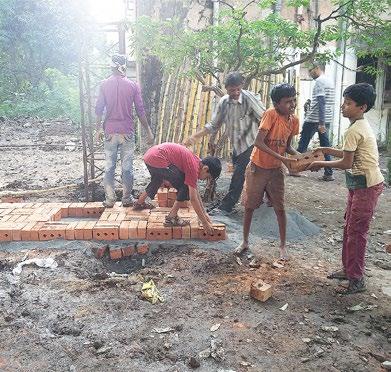
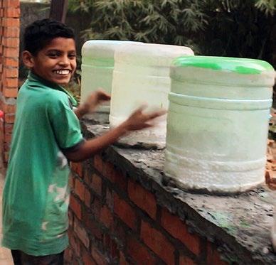
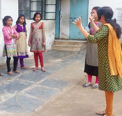
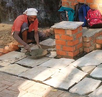
We began the next stage of work via interaction with the users. We discussed on what they envisioned the place to be and in turn, they helped us with suggestions as well as on-site execution. For instance, with the material truck stuck at a distance, the children formed a human-chain and helped us procure the materials on site. Such participation induced a sense of belonging amongst them.
RECTIFICATION
After inquiring from the users and their families, we concluded that these kids lacked durable swings and seating spaces. In order to rectify our mistakes, we began with the strengthening of existing furniture via welding and concrete as well as introduction of new robust slides and seats as per children’s requirements.
USER-CENTRICITY IN DESIGN
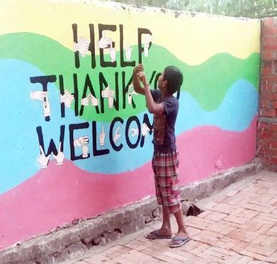
User-centric design being the basis of our proposal and deaf kids being our major user group, we added elements for which one doesn’t necessarily need a ear to understand sound, one can feel it through its vibrations too. This was achieved via the usage of 3 materials of varying densities and quantities in 3 bottles each. Striking these produced a range of vibrations that the kids could feel. Additionally, we painted signages as a guide for the visitors in order to establish an effective conversation with the children.
39
POST OCCUPANCY EVALUATION
LIGHTER ELEMENTS IN A UNUSABLE CONDITION
INTERACTION WITH THE CHILDREN USING SIGNAGES
STRENGTHENING OF FURNITURE EXPERIENCING SOUND THROUGH VIBRATIONS
RIGID
ELEMENTS EFFECTIVELY BEING USED
HUMAN-CHAIN
HELPING IN THE PROCUREMENT OF MATERIALS INTRODUCTION OF SEATING SPACES AS PER REQUIREMENTS SIGNAGES AS A GUIDE FOR EFFECTIVE COMMUNICATION
– Jane Jacobs

Cities have the capability of providing something for everybody, Only because and only when they are created by everybody.
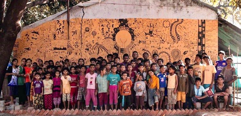
I CLEAN TEAM NMC, NAGPUR LOCAL COMMUNITY VARIOUS INDIVIDUALS HAPPY TO CARE ROTARY CLUB KOKATE ASSOCIATES PAUL BRICKS SDPL CONSTRUCTION AJMERA TYRES Dee Vee CONSTRUCTION CONTRIBUTION BY STAKEHOLDERS PHYSICAL SUPPORT MATERIAL SUPPORT LAST DAY ON SITE WITH THE STUDENTS BRICK BY BRICK ... bringing individuals together “ “
PROJECT DETAILS
Professional Work
Bamboo Development Board
Spring 2020 - Fall 2021
Team Members :
Project Head - IFS Officer TSK Reddy
Design Lead - Ar. Ganesh Harimkar
Senior Architect - Vedant Amrutkar
Junior Architect - Shhrruti Jain
Site Supervisor - Kapil Khadatkar
Model Maker - Kunal Wagh
Group of 8 exceptional artisans
ETHICS AND AESTHETICS ... a sustainable way of life
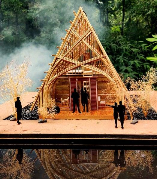
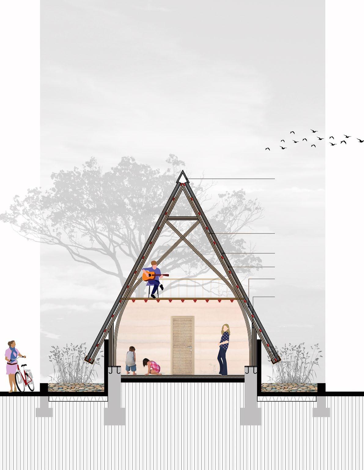
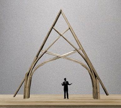
BAMBOO ECO-COTTAGE NAGPUR, MAHARASHTRA, INDIA
Can we achieve the masterful balance of meeting our own needs without jeopardizing the future generations’ ability to do the same? Can incorporation of local materials contribute to this way of life?
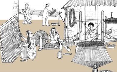
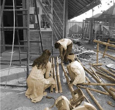
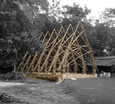
With rising concerns about climate change, bamboo has emerged as a promising building material as it consumes less energy. It is a highly renewable and fastest growing material and possesses properties which make it apt for effecting sustainable development. The Bamboo Development Board was thus established by the Government of Maharashtra in 2016 with a mandate to promote bamboo plantation and product development by assisting RnD, skill development and awareness generation for incorporation of bamboo as a key material in the construction and manufacturing sector. The Eco-Cottage, a prototype for recreational dwellings in the adjacent forest resorts is a resultant of the efforts of the artisan community in working with local bamboo and the efforts of the board in conducting training programs for artisans and designers, thereby facilitating capacity building.
41 06
DETAILED PHYSICAL MODEL SHOWING FRONT ELEVATION OF THE ECO-COTTAGE
TRANSLUCENT
CORRUGATED BAMBOO
WOOD LAYERED WITH BITUMINOUS WATERPROOFING
PURLINS

BUNDLED
RIDGE CAP
GLASS FIXED ON ALUMINUM SECTION FRAME
ROOFING SHEET PLY
MEMBRANE BAMBOO
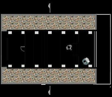
BAMBOO FRAME VESTED STEEL SOFFIT PLAN AND SECTION OF THE ECO-COTTAGE DOUBLE HEIGHT LIVING +0.60 m 0.00m+0.30 m BEDROOM WITH DECK ABOVE +0.60 m WASH AREA
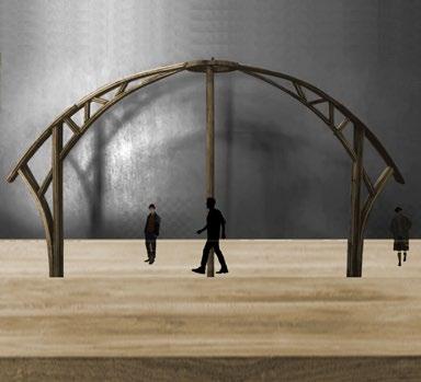
DESIGN EXPLORATION
The project began with experimentation in form to obtain a shelter with the best combination of structural stability, material feasibility and aesthetics. This was accompanied by sectional sketches in order to gauge the quality of the resultant interior spaces.
RESOLVING DETAILS
Having arrived at one such prototype, a layerby-layer resolution of the model was carried out. Being a complex structure, this was achieved by a combination of hand-drawn sketches, virtual 3D modeling, with the final results being obtained in physical models.
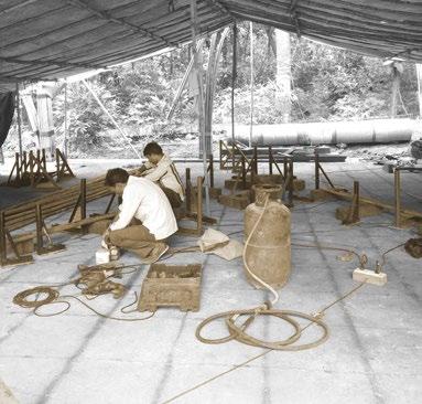
COMMUNITY TRAINING
Alongside the design process, one of the most important aspects was imparting skills to the youth regarding construction techniques involving bamboo, a potential building material of the future. This was accompanied by collaboration with various stakeholders.
43
01 02 03 EXPERIMENTS WITH STABILITY, FEASIBILITY AND AESTHETICS COLLABORATION WITH STAKEHOLDERS COMMUNITY TRAINING PROGRAM ARRIVING AT THE BEST CONFIGURATION FOR THE TRUSS WORKING ON DETAILS THROUGH PHYSICAL MODELSEXPERIMENTS WITH STABILITY, FEASIBILITY AND AESTHETICS FEASIBILITY AND STAKEHOLDERSARRIVING THE BEST CONFIGURATION TRUSS
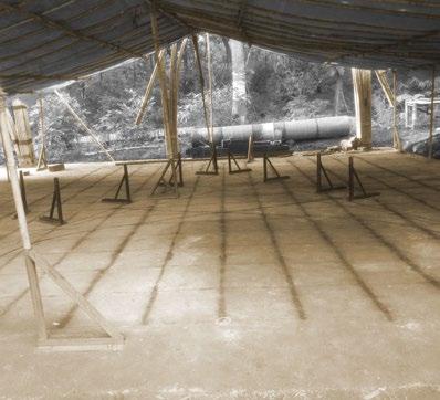
ON-SITE PREPARATION
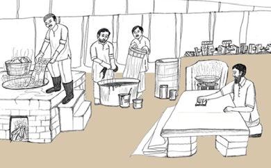
With an intent to achieve the built solution in the most sustainable manner possible, apart from the truss, the plinth, supports as well as interiors were also planned in bamboo to reduce the intake of high energy consuming materials.
ASSEMBLING ON SITETRUSS TAKING SHAPE
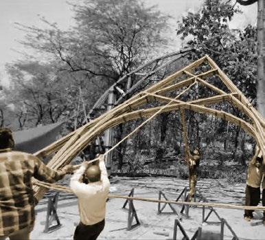
Experiments for the truss were done with variations of local bamboo in order to obtain the desired stability and aesthetics. The cottage consisted of 7 trusses with each truss comprising 7 layers of bamboo and taking approximately 20 days for making.
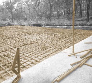
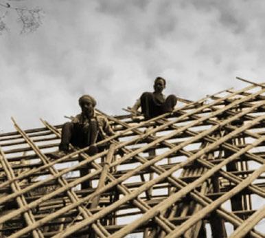
The current stage of working involves assembling the trusses on site with roofing details taking shape simultaneously. This will be followed by tying them together to prevent movement against the winds, post which the interior elements will begin to take shape.
04 05 06
TRUSS TAKING SHAPE
ERECTION OF THE TRUSS ON SITE
BASIC SKELETON OF THE ROOFING IN PROCESS
BASIC SKELETON OF THE COTTAGE IN PLACE
BAMBOO REINFORCEMENT FOR PLINTH
GRID CALCULATION FOR ASSEMBLING ELEMENTS OF TRUSS
PROJECT DETAILS
Internship Work
A collaboration between Cornell Center for Cities & SDI Kenya
Summer 2022
Team Members :
Project Head - Joe Muturi
Project Lead - Charity Mwangi
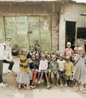
Planners - Rogers Otieno, Michelle Koyaro & Milka Kori
Interns - Nicholas Wilsey & Shhrruti Jain
Exceptional team of
ARISE: MAPPING AND ANALYSIS
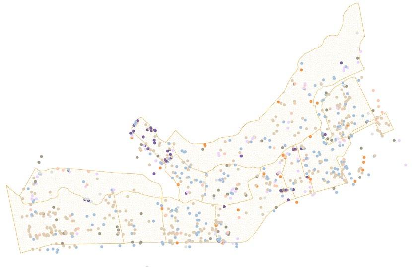
SLUM DWELLERS INTERNATIONAL (KENYA) AND CORNELL CENTER FOR CITIES NAIROBI, KENYA

Can mapping and analysis contribute towards improving the lives and living conditions of communities residing in informal settlements?
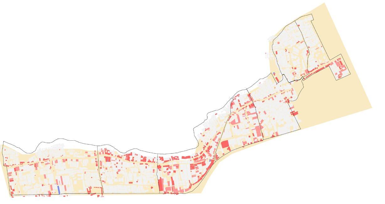
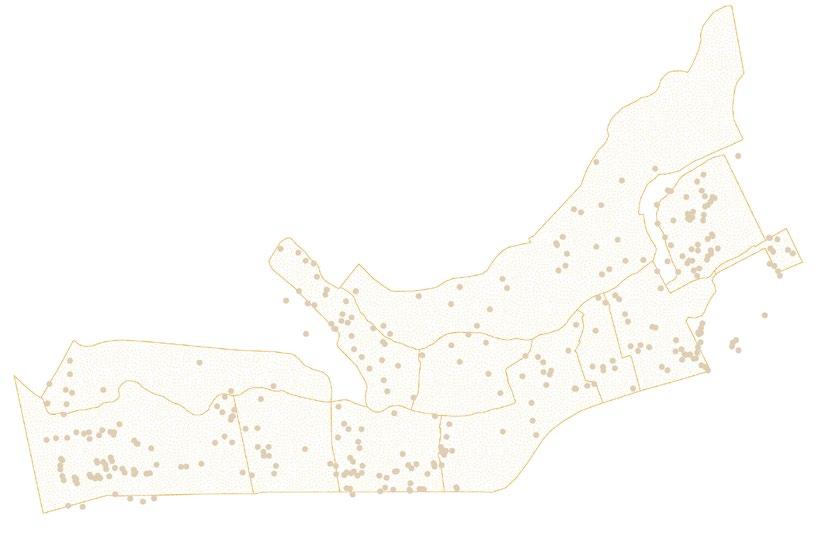
The work is part of an ongoing project aimed at improving the infrastructure within informal settlements in Nairobi, Kenya through a partnership between Slum Dwellers International and Muungano wa Wanavijiji. The research, mapping, analysis, findings and recommendations are specific for upgrading basic services and infrastructure within Mabatini Ward in Mathare Settlement. The Mathare Valley - one of the largest informal settlements in East Africa lacks even the most basic services. Despite recent national slum-focused planning policies, no comprehensive development plans currently exist that integrate physical and social planning for Nairobi’s large slums. Infrastructural improvements therefore rank as the top priority among Mathare residents. The work aims to act as an initial step towards community-led, comprehensive development for Mabatini Ward in Mathare Settlement. Mathare residents deserve improved services and living conditions and the analysis aims to contribute to this outcome.
BASE
RECOMMENDATIONS
COMMUNITY
DATA COLLECTION
MAPPING
TEMPORALITY

DIGITIZATION OF COLLECTED
ON GIS & EXCEL FOR
MAPPING
45 07
community partners & stakeholder organizations.
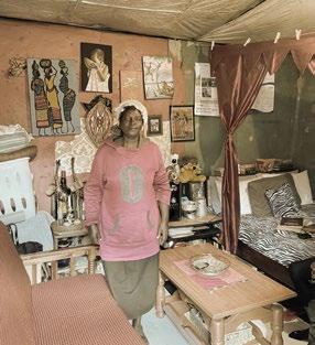
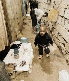
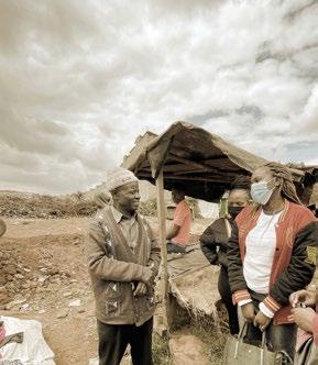
VILLAGE 4A, MABATINI WARD, MATHARE DISMAL HYGIENE COMMUNITY MEMBER RESIDENCE SUBSTANDARD LIVING CONDITIONS STAKEHOLDER MEETING
MAP PREPARATION FROM GOOGLE MAPS FOR ON-SITE MAPPING
FOR UPGRADATION & DECLARATION AS A SPECIAL PLANNING AREA
AWARENESS AND TRAINING WORKSHOPS IN THE SETTLEMENT
& ANALYSIS TO IDENTIFY GAPS IN EXISTING INFRASTRUCTURE
AND PROFILING ON GROUND; UNIQUE ADDRESS ALLOCATION
DATA
ANALYSIS AND
HOUSEHOLD ENUMERATION & POPULATION ESTIMATE


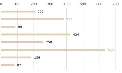
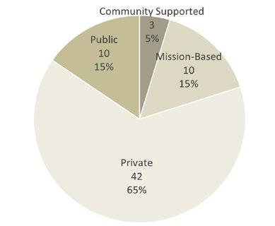
Villages No. of Households
4028 9970
3A 2228 4395
3C 1586 3813
Village 10 1570 4394 Mashimoni 3980 7623 Mabatini 1160 2230
Kwa Kariuki 1852 4092 Ward Level 16,404 36,517
POPULATION DENSITY ESTIMATE
VillagesAreas (acres)Population
3B 16.35 610
3A 10.52 418
3C 10.21 374
Village 10 8.93 492 Mashimoni 12.00 635 Mabatini 4.65 480 Kwa Kariuki 5.17 791 Ward Level 67.83 538
MATHARE SETTLEMENT AND MABATINI WARD
Mabatini

Villages in Mabatini Ward:
1. Mathare 3B
Mathare 3A
Mathare 3C
Village 10 5. Mashimoni
Kwa Kariuki 7. Mabatini
1. 2. 3. 4. 5. 6. 7. The Mathare Settlement in Nairobi, Kenya comprises 4 wards: Hospital Ward, Utallii Ward, Mlango Kubwa Ward and
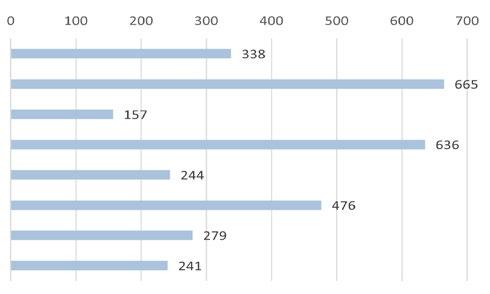
Ward. This report focuses primarily on Mabatini Ward that houses 7 villages for a total of 4,738 structures, 16,404 families and 36,517 people. 1. 2. 3. 4. 0 20,00010,000 40,000 50,00030,000 60,000 Ward Level Village 10 Village 3A Mabatini Village 3B Mashimoni Village 3C Kwa Kariuki 0 200 500100 400300 600 Ward Level Village 10 Village 3A Mabatini Village 3B Mashimoni Village 3C Kwa Kariuki
Population Estimate 3B
Density Per
Wards in Mathare Settlement: 1. Hospital 2. Utalii 3. Mlango Kubwa 4. Mabatini
2.
3.
4.
6.
Exclusively residential structures occupy a majority of the Mabatini Ward whereas businesses are concentrated around two corridors. The first corridor is the interior road that runs east-west through the ward. This corridor reflects an inward-facing development pattern. Because it has limited access to the rest of Nairobi, businesses primarily serve the residents of the immediate area in Mabatini. The second corridor is Juja Road along the southern boundary of the Ward. These businesses comprise transit-oriented development that serves customers from within and outside of the settlement. Connectivity along this corridor will be improved with the future construction of a bus rapid transit route along the road. Compared to the interior road, there are fewer businesses recorded, partially due to limited data in the Mathare 3A Village along Juja Road.
Land uses other than residential and business, such as education and utility facilities, are evenly distributed across the ward. Given the geographic location of Mabatini Ward, there is limited space for additional development. Encroachment on the Mathare River, along the northern edge of Mabatini, creates flooding hazards for residents while Juja Road on the ward’s southern edge creates another boundary on growth. The eastern and western edges of Mabatini are other wards within Mathare, so they also create boundaries on growth. Therefore, in order to accommodate additional population growth, Mabatini must expand upward with greater density and formal buildings.
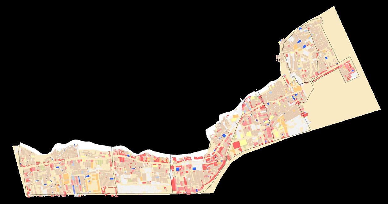
LAND BUDGET
BUSINESS CORRIDORS

LAND BUDGET
47 LAND BUDGET AND BUSINESS CORRIDORS
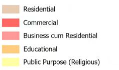
STRUCTURE
Kariuki
3B
3C
Mabatini
Kariuki
STRUCTURE TYPES


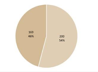
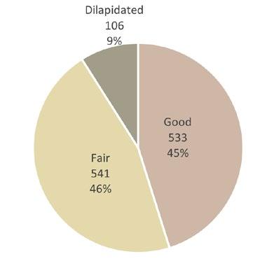
Within Mabatini, a majority of structures are single floor with only 366 structures in the entire ward being taller than one floor. This structure pattern is closely related to the structure types found in the Mabatini Ward. 92% of structures are classified as temporary structures and made with materials such as corrugated metal, mud and wood, while 7% of the structures are permanent. Underscoring the significant prevalence of temporary structures is the lack of land tenure in the settlement. Land is owned by outside actors and residents rent their structure and land. Because they do not own the land on which they live, residents are thus hesitant to significantly invest in formal housing when they could be evicted. This lack of formal housing makes residents vulnerable to climate hazards, such as flooding along the Mathare River and fires.
Ward Level Village 10 Village 3A
Village
Mashimoni Village
Kwa
500 25001500 3500 40000 1000 30002000 Ward Level Village 10 Village 3A Mabatini Village 3B Mashimoni Village 3C Kwa
5,000 25,00015,000 35,0000 10,000 30,00020,000
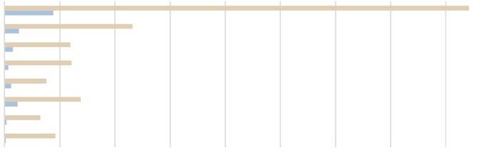
TYPES AND HEIGHTS Lowest Rent Permanent Highest Rent Temporary STRUCTURE HEIGHTS
WATER
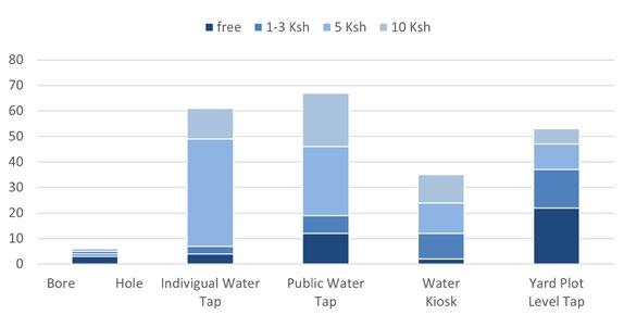
Water points are critical facilities for residents of Mathare, who rely on them for drinking, cooking and cleaning. The most common source of water were the county main water network. Other sources of water include wells, which have the possibility of being polluted due to nearby dumping and contaminated groundwater. These water points pose health threats to Mathare residents. To receive water, costs per liter of water ranged from free upto 10 Ksh. Most water sources were paid for and the most common price for a liter of water was 5 Ksh. For residents of Mathare facing poverty, paying for water can be a significant economic burden and costs are often higher than in formal settlements in Nairobi. 30 meter buffers around water points show that while some residents have close access to a water point, many are forced to walk a significant distance to access the critical resource. Particularly in the Mathare 3C Village, there were limited water points recorded, indicating that obtaining water has the potential to be a burden for local residents.
County Main Water Network
Private Borehol/Well Water Bowser
Others
TYPES OF WATER POINTS AND COSTS
Ward Level Village 10
Village 3B Mashimoni
Village 3A Mabatini
Village 3C Kwa Kariuki
PERSONS PER RECORDED WATER POINT
30 METER BUFFERS FROM WATER POINTS IN MABATINI WARD
49
FACILITIES
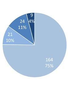
SANITATION FACILITIES

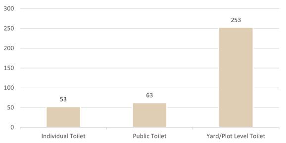
Toilet facilities are also distributed across Mathare and serve the essential purpose of storing human waste. The most common type of toilet facility recorded was yard and plot level toilets, followed by public toilets and individual toilets. To go to the bathroom, most toilet facilities required payment from residents. Similar to accessing water, this requirement of payment can be burdensome for those in poverty, and have negative incentives that encourage residents to not utilize formal toilet facilities. Given the density of Mathare and limited drainage infrastructure, using the bathroom outside of a toilet facility or using a toilet facility that does not properly isolate waste creates a public health hazard that can lead to disease in those exposed. 30 meter buffers around toilet facilities demonstrate that many residents do not have convenient access to a toilet facility from their home. Particularly at night, when there can be safety concerns, this dis-incentivizes residents from using established facilities.
METER BUFFERS FROM TOILET FACILITIES IN MABATINI WARD

 PERSONS PER RECORDED TOILET TOILET FACILITIES
30
Payment Required No Cost Ward Level Village 10 Village 3A Mabatini Village 3B Mashimoni Village 3C Kwa Kariuki
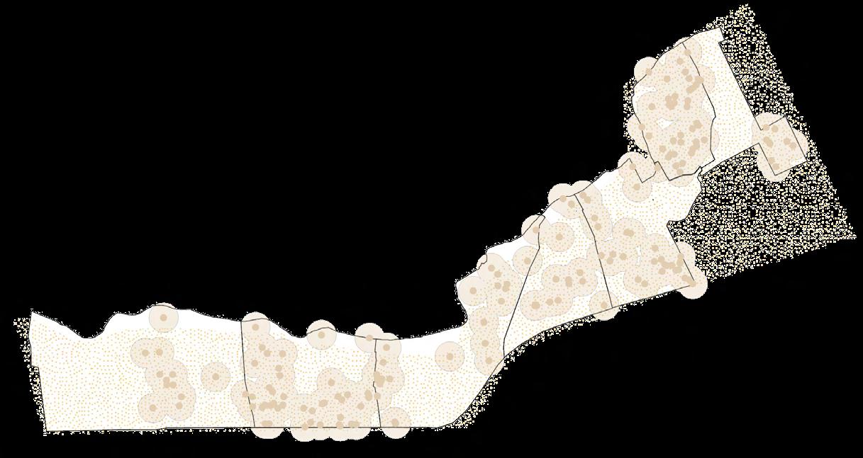
Facilities for the entire settlement were collected utilizing GPS technology on site in addition to the manual recording of the features for each facility. These facilities included water facilities, sanitation facilities, community centers, health facilities, markets, public spaces, waste collection facilities, flood and street lights, police stations, community kitchens, hand washing facilities, religious institutions, shade garages, administrative offices and NGO offices. Generally, facilities were distributed evenly throughout the settlement with concentration along roads and pathways.
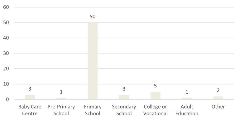
EDUCATION FACILITIES
TYPES OF SCHOOLS
WASTE COLLECTION FACILITIES


TYPES OF

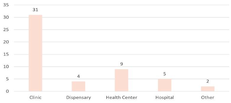
HEALTH FACILITIES
LEVELS OF EDUCATION


TYPES OF HEALTH FACILITIES
51 OTHER FACILITIES
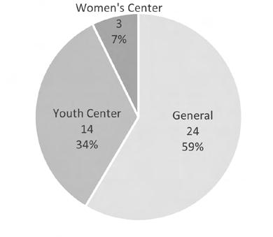
WASTE COLLECTION FACILITIES Water Points Sanitation Facilities Schools Community Centers Waste Collection Facilities Health Facilities Markets Public Spaces
COMMUNITY CENTERS
MARKETS PUBLIC SPACES
AGE AND QUALITY OF FACILITIES
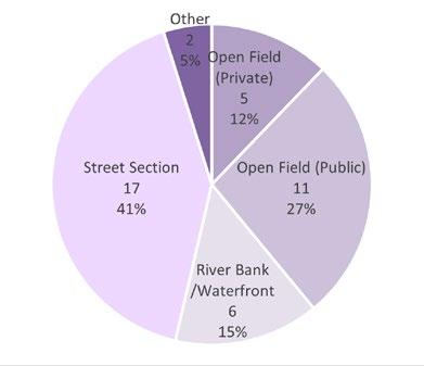
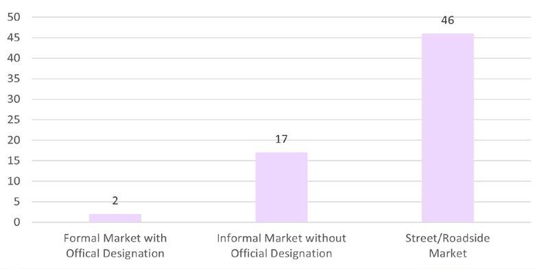
TYPES OF COMMUNITY CENTERS TYPES OF OPEN PUBLIC SPACES ACCESSIBILITY IN COMMUNITY CENTERS TYPES OF MARKETS
PROJECT DETAILS
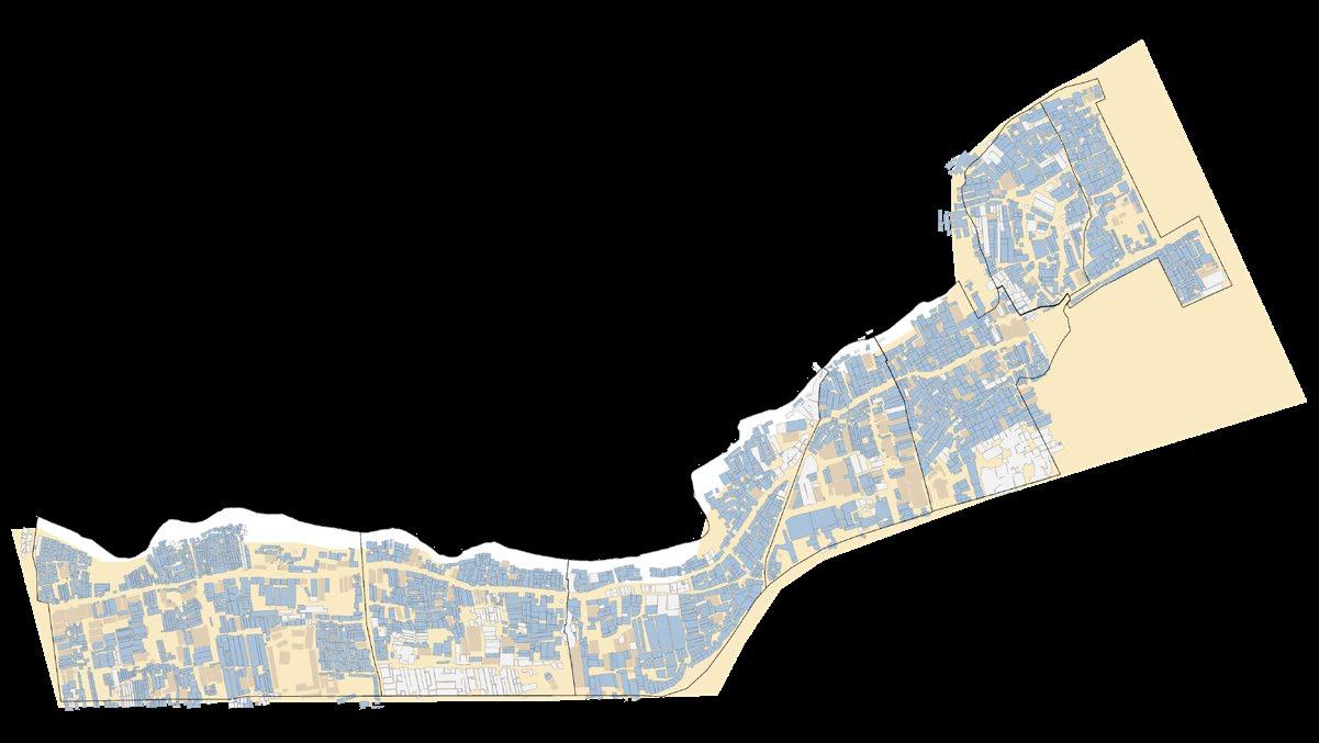
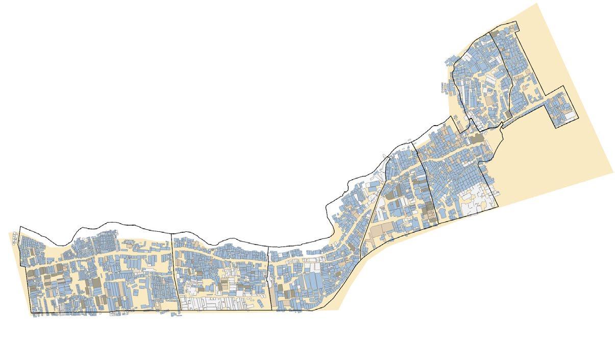
NEIGHBORHOOD ANALYSIS: STUDENT
GIS & MAPPING ELECTIVE, CORNELL UNIVERSITY MANHATTAN BOROUGH, NYC
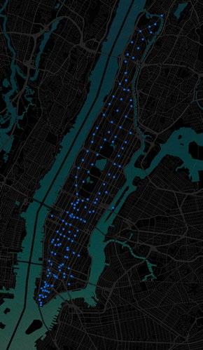
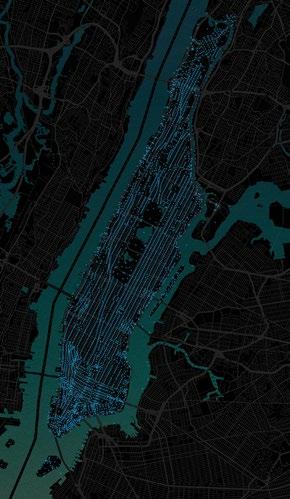
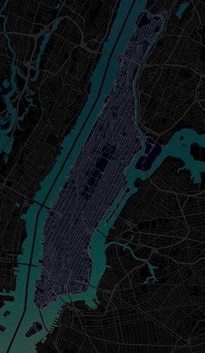

Can mapping tools aid in the creation of datasets that steer individuals towards a holistic way of living and working?
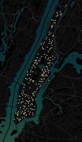
New York City, especially Manhattan is a hub for universities and is known for its competitive rental market. A majority of online platforms that allow students to find apartments mainly present information based on price, location and distances as key criteria. Students are supposed to finalize housing options online without having any other spatial information such as nearby amenities that are crucial for their living. It thus becomes an overwhelming experience for newcomers, especially international students to find off-campus housing options that meet their criteria whilst being near their school. The study aims to create a catalog for the borough of Manhattan within New York City that showcases desirable blocks for students based on their selected priority of criteria. The methodology can be used for larger geographies and can encompass various other attributes such as safety, access to healthcare facilities, access to facilities for kids etc. in order to provide a more holistic analysis. This would give a clear idea of suitable neighborhoods/blocks following which the student can loop back into existing online platforms to make a final decision.
Guided by Professor Waishan Qui
Members: Phasit Rattanachaisit Shhrruti Jain
53 08
HOUSING
Academic Work Elective Final Project Spring 2022
Team
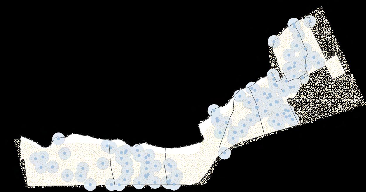
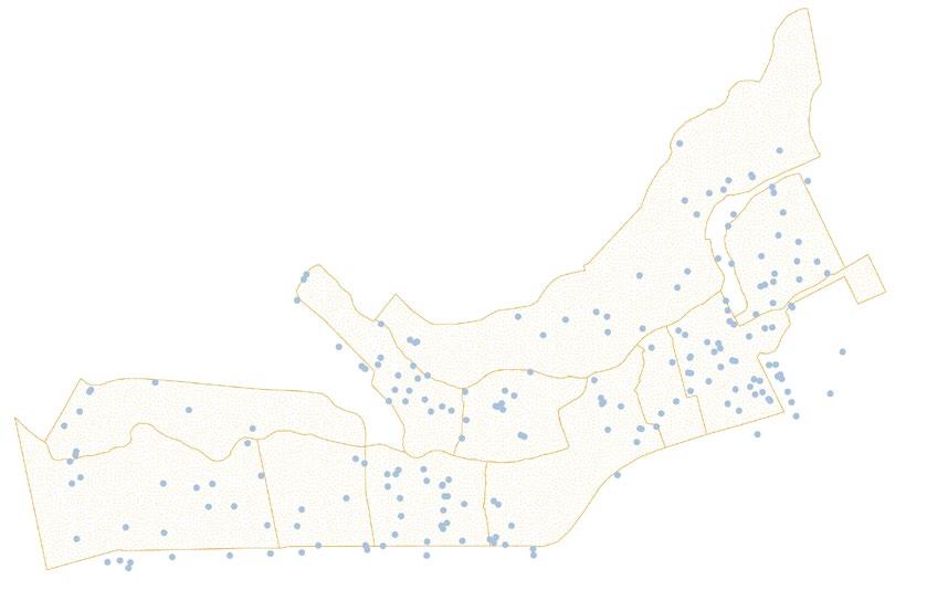
My contribution: Problem Statement & Mapping Census Blocks 1/2 Radial
Distance from Census Block Centroid
Subway Stations Census
Block Centroids
Healthy Food Facilities Recreational Parks
Apart from price, location and distances, the choices of places where students want to live is also dependent on their personal interests and criteria. The hypothesis is that dividing student criteria into categories and using these measures to evaluate city blocks within Manhattan could be more effective in finding suitable living locations for students. The layering in GIS will serve as a base for statistical analysis while the color-coded output maps will serve as the guiding data for making housing decisions. Within Manhattan, the idea is to understand each block’s composition of the above identified criteria using spatial tools such as “join count”. This would be followed by having different combinations of priorities such that each student can refer to data that is most suitable to their interests.
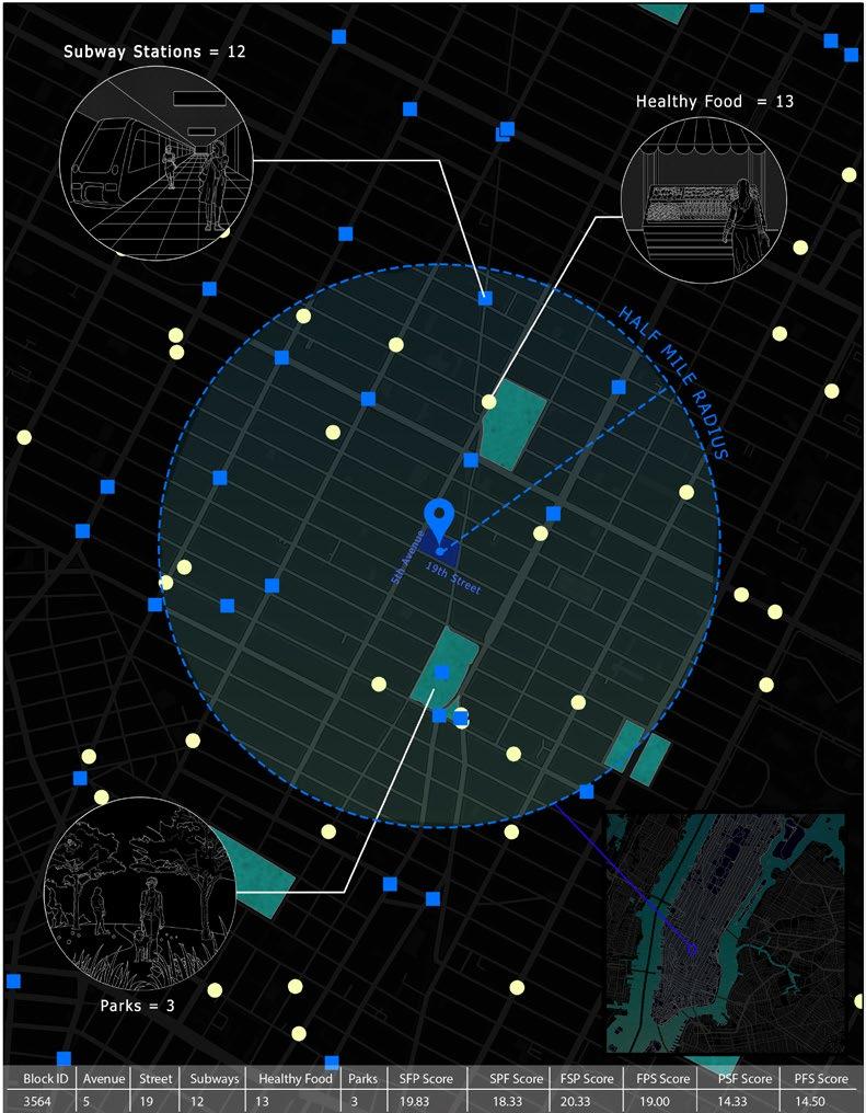
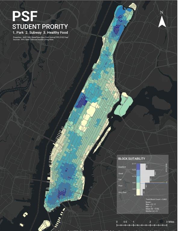
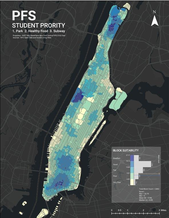
This study comprises 6 different scenarios based on different priorities of criteria that would be:
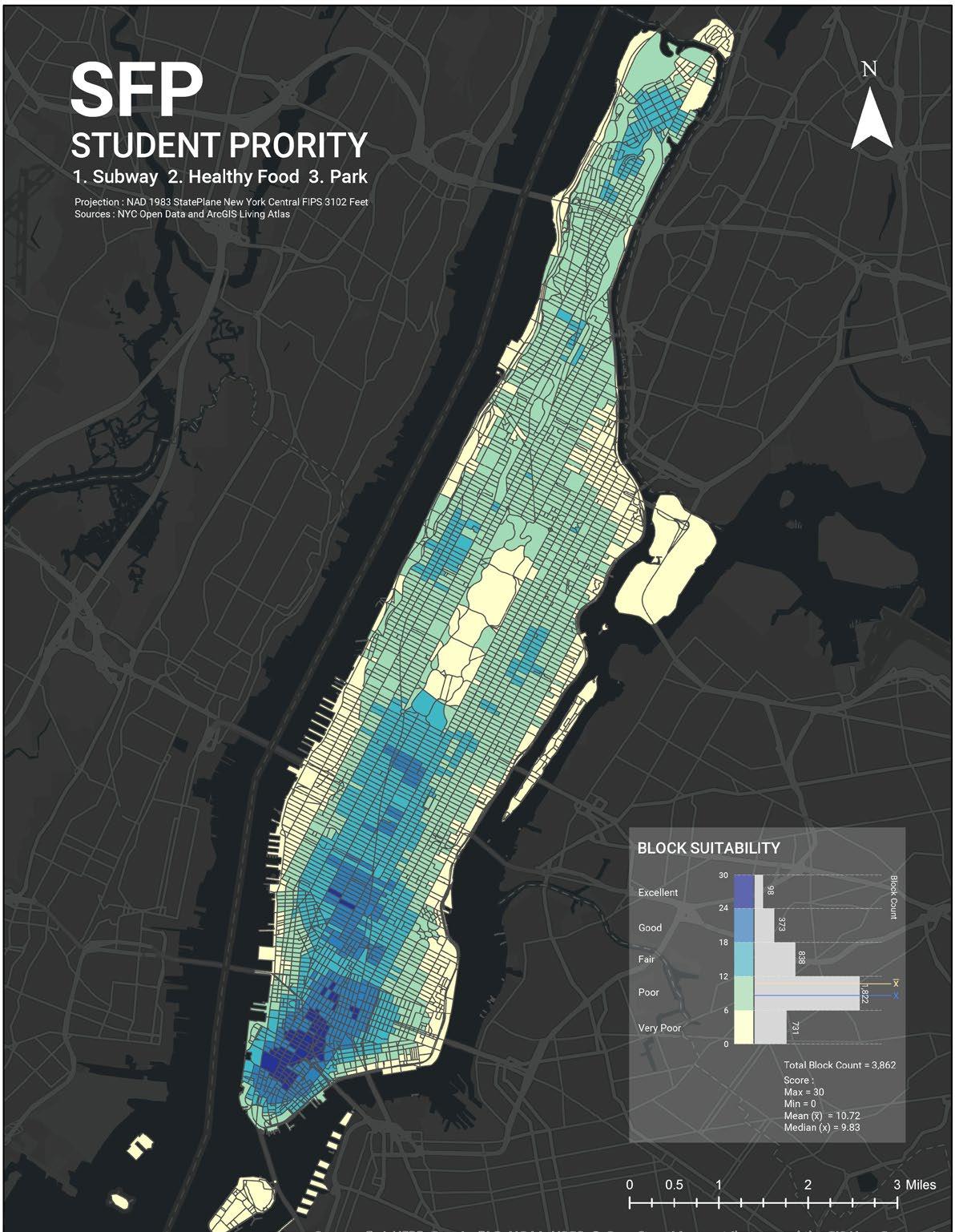
SFP (1. Subway 2. Healthy Food 3. Park)
SPF (1. Subway 2. Park 3. Healthy Food)
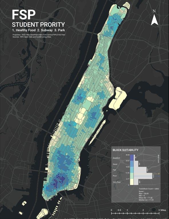
FSP (1. Healthy Food 2. Subway 3. Park)
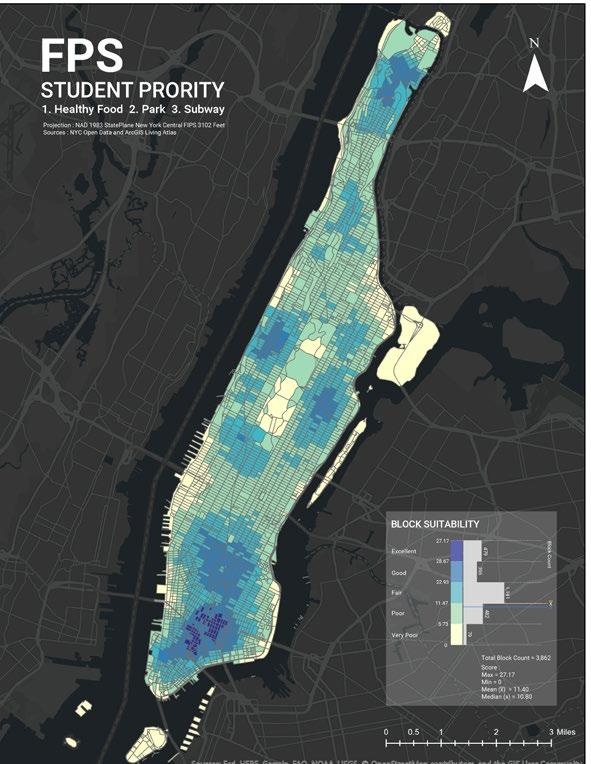
FPS (1. Healthy Food 2. Park 3. Subway)
PSF (1. Park 2. Subway 3. Healthy Food)
PFS (1. Park 2. Healthy Food 3. Subway)
map to explain the process and concept of join count followed by calculate field

To test the hypothesis, three broad categories of common students’ criteria have been identified:
SUBWAY STATIONS
HEALTHY FOOD FACILITIES
HYPOTHESIS
Zoomed-in
(S)
(F)
(P) RECREATIONAL PARKS
55

F I N . THANK YOU sj553@cornell.edu
