
XANDER SHAMBAUGH Portfolio
Contents
The following portfolio contains selected works from my undergraduate education at the University of Virginia. Unless otherwise stated, all projects were designed independently.
Professional work available upon request.
ANOTHER 34,000 A DAY
Foundation Studio III | Spring 2017
Another 34,000 a Day offers an efficient, affordable, and adaptable solution to the devastating refugee-housing crisis. According to the UNHCR, 65 million people today are categorized as refugees and on average 34,000 people a day are forced to leave their country in search of safer, better environments. This proposal is comprised of three distinct stages, each designed to accommodate any site, scenario, climate, and or population. While a displaced person’s first priority is to find shelter, this study begins with the rapid deployment of an expanding tensile fabric structures and continues to the final design of a geodesic public services building for the nearby refugee community. From shelter to community
to city , the primary goal of this investigation is to act as a catalyst for assimilating a group of displaced people into the rhythm of an unfamiliar urban fabric. The following work demonstrates a case scenario implemented in Portland, Maine.

2018 Published in the Virginia Architecture Magazine
2018 Published on The Archiologist
2017 Featured in research journal Lunch: Vol. 12

STAGE 1: SHELTER
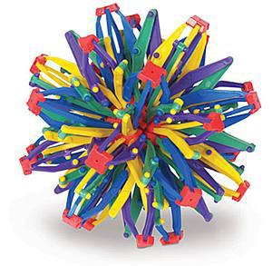
Stage 1 prioritizes the immediate rescue, relief, and refuge of a displaced group of people. This process begins with the shelter and prioritizes a compact and adaptable housing unit that can be easily transported, deployed, and assembled on site. The driving force behind this particular design began with the joint: the lattice system behind the structural design evolved out of an iterative design process inspired by the popular children’s toy, the Hoberman Sphere

TRANSPORT + DELIVER
Air-drop compatible in emergency case scenarios.
UNLOAD ONTO SITE
BUILD FOUNDATION
Foundation can be raised and supported by wooden piles. In colder climates, a concrete foundation will utilize its thermal mass as a natural heating device.
EXPAND FRAME
Timber frame unfolds and expands into a shelter 8 times its original size (when packaged).
STAGE 2: COMMUNITY

Stage 2 defines a transitional period in which the refugee population live at a semi-permanent camp that provides basic resources such as free housing, medical and psychological relief, food and supplies, transportation to the nearest city, and most importantly, a sense of community. Applying this scenario to the case study of Portland, Maine, this hypothetical group of refugees would reside at the Chewonki campground just outside of the small town of Wiscasset, Maine. As an ideal location, Camp Chewonki is a one-hour drive from Portland, located directly adjacent to the Wiscasset airport and sitting on a body of water accessible by the Atlantic Ocean.
Camp Chewonki has the open space to house 12 to 16 UNHCR block containing 8 refugee shelters and 1 service center taking desic dome. Each service center provides WC facilities, a kitchen, and medical resources. The primary focus of this transitional provide necessary living resources, but to foster a sense of community distressed refugees, as well as start to integrate them into the offering transportation to and from its core.
UNHCR sub-blocks, each taking the shape of a geokitchen, a small garden, period is to not only community among the the city of Portland by


STAGE 3: CITY
The third and final stage proposes the construction of a refugee Community Center near Portland’s eastern waterfront. The primary purpose of this center is to act as a cultural catalyst for integrating a new refugee population into the city of Portland. Furthermore, this building is not intended to be a singular enterprise aimed only toward refugee public services; rather, it aspires to become a comprehensive cultural center facilitating a true appreciation and openness to both refugee and local communities. Programmatically, the Portland Cultural Center will
provide subsidized housing; a career services center; a day-care; as well as ample commercial-retail space, giving refugees the opportunity to showcase their foreign culture and unique set of skills. From the expanding joint to the unraveling of the building’s structural envelope, the Portland Cultural Center seamlessly emerges from the adjacent waterfront becoming a major centerpiece of the city’s Eastern Park Promenade.

LIVING ON THE EDGE Foundation Studio II | Spring 2016
The Preston Avenue area is currently a lifeless traffic corridor that lacks a true sense of community and cohesion. In addition to a periphery of empty parking lots, the avenue’s most underutilized land lies directly between four lanes of traffic, creating a major barrier for pedestrian circulation. This proposal explores a new housing typology built directly above Preston Avenue’s median This unique development aims to bridge two disconnected neighborhoods while assessing the possible benefits and drawbacks of building along a 50-foot wide median.
In an attempt to provide housing without ascend along the median, lifting the building’s low. Rather than acting as a wall dividing at critical moments along the median, providing a more exciting way of living.

without further obstructing cross-circulation, a zig-zagging promenade will building’s first floor above street level in order to create a public space beNorth and South, Preston Avenue’s new housing block will reach out providing access to a new public linear park while experimenting with


SITE PLAN

Zooming into a major commercial and vehicular node, this proposal intends to restructure the mobility both along and across Preston Avenue. Strategic interventions will increase pedestrian accessibility by slowing traffic velocity, adding new parking lanes, and improving cross-walk circulation.
URBAN STRATEGY
As an urban tool attempting to bridge two disconnected neighborhoods, Living on the Edge fully embraces its ambitious goal and aims to continue further along Preston Avenue’s median, reaching out and connecting critical commercial areas in an attempt to merge them into one long corridor. In doing so, it will connect two major commercial hubs within Charlottesville, VA — the Preston Avenue Corridor and the popular, pedestrian friendly Downtown Mall .

This unusually thin structure will exploit the site’s width constraints by testing the strategic orientation of its apartment units and access points. Primary circulation will proceed from the North, as students ascend a long, meandering promenade closest to the University of Virginia’s main campus. A smaller promenade zig-zags underneath the structure, providing access to the building’s central core.
The unique promenade experience continues up and into each housing unit. Circulatory paths dictate the organization of private and public spaces in order to minimize the need for doorways and other barriers. To accommodate the median’s variation in width, the Preston Avenue housing block will be comprised of two distinct apartment styles: the Family Unit and the Student Unit.
THE YAMUNA RIVER PROJECT
Research
Studio | Fall 2017
The data shown in the drawings above was produced by a collaborative research team. Line-work such as roads, rivers, drains, etc was recorded in a collective effort to map the city of New Delhi as part of The Yamuna River Project. My greatest contribution can be attributed to the mapping and tracing of New Delhi’s urban fabric in the following series of figure-ground studies. All post-processing and diagramming displayed in the following drawings was completed entirely by myself and became the foundation for the research conducted in the following project, Majlis Park Place. The following diagrams represent a series of figure-ground stud-

ies conducted as part of The Yamuna River Project. They document the city’s urban “figure” in contrast to the agricultural “ground,” or green space, within and along the edge of New Delhi. In tracing the chaotic urban fabric, I determined there should be a complete re-thinking and re-defining of Delhi’s city line to accommodate and re-structure the true extent of Delhi’s urban boundary.
2018 Featured on The Archiologist Magazine
Yamuna River Floodplain

City & River
The Yamuna River cuts directly through the center of New Delhi’s urban core. As a result, its massive floodplain acts as an urban moat, dividing New Delhi’s urban fabric into two distinct regions and creating a major disconnect between the city and the river.
Metabolic City-Region
This disconnect resonates throughout New Delhi as its citizens continue to litter the streets, green spaces, and storm-water drains with little to no awareness of their collective and catastrophic behavior.

MAJLIS PARK PLACE
As the Yamuna River enters New Delhi from the North, its water transforms from a natural green to a dark black as it merges with the Najafgarh Supplementary Drain. This discoloration can be attributed to the unprecedented toxicity of New Delhi’s storm-water drainage system, resulting from a culture of poor waste management, little-to-no trash disposal, and a serious lack of hygienic awareness.

As the final metro station along New Delhi’s recently constructed Pink Line, Majlis Park will play a momentous roll in the re-structuring and the re-centering of northern Delhi. Majlis Park Station is located half a mile south of the Najafgarh Supplementary Drain,
providing an immediate source of transportation to a heavily populated and disorganized urban fabric. While the location seems appropriate, the site currently faces enormous barriers of accessibility, circulation, and organization due to a lack of pedestrian crossings over a system of highways, ring roads, and polluted storm-water drains. This project investigates the possible expansion of the current Majlis Park Station in order to accommodate an even greater influx of people, automobiles, and trains.
Comprehensive Master Plan

As part of a collective Master Plan, Majlis Park Place contributes to the complete restructuring of northern Delhi’s Najafgarh Supplementary Drain. This proposal transforms a newly constructed metro station into a trans-modal hub of new centrality.

The following photos and site analysis were taken by myself during a site visit to New Delhi. Over the course of 10 days, a research team and I documented and reflected on the devastating and blatant contamination of the sacred Yamuna River.
Metro Station Bus Stop
The new Majlis Park Metro Station is currently under construction and is located half a mile south of the Najafgarh Supplementary Drain.


Without a proper intercity bus station, buses and other vehicles create a major barrier for pedestrian circulation.

Marshland

Sewage Treatment Plant
 Resettlement Housing
Majlis Park Station
Sewage Treatment Plant
Resettlement Housing
Majlis Park Station
Sewage Treatment Plant
E cological Disconnect
Highways and storm-water drains currently obstruct access to potential green spaces.
Circulation
The adjacent highway is a major vehicular artery for the Outer Ring road and its intercity bus routes.
E cological Connection
Storm-water drains have the opportunity to become major ecological connectors, while restoring and revitalizing adjacent marshlands.
Accessibility
High velocity traffic creates a enormous barrier for pedestrian circulation and forces nearby communities to cross over barren marshlands due to a major disconnect between the station and its surroundings.
E cological Anchors
Each “arm” of the trans-modal platform will seamlessly connect to its surroundings, facilitating the transition from ground to station.
Transmodal Hub
Expanding Majlis Park from a single station into a mixed-use transportation hub will tremendously improve its current state of mobility. The redistribution of circulatory paths onto multiple levels will result in a more efficient bond between the Metro and Intercity Bus system.
Majlis Park Place
Transforming from a single metro station into a mixed-use, inter-modal urban connector, Majlis Park Place will very simply and strategically reorganize and redistribute the circulatory paths of a pivotal intersection within New Delhi’s outer ring road. This expansion entails the addition of an intercity bus station adjacent to the newly constructed metro rail while simultaneously establishing itself as a major node of centrality for the nearby communities.


Delhi’s Metro Rail
This metro expangrowth along high-dendevelopment along the Metro lines and a the metabolic restops will act as the nodes of rural and and waste manage“grid” of landfills, by one unified tranthe Urban Generregions — turning waste relationship.
education at the designed inde -
ABSTRACT
MAJLIS PARK PLACE
Fall 2017
The Yamuna River Project
Instructors: Inaki Alday + Pankaj Vir Gupta
AN INFORMAL URBAN GENERATOR
Spring 2018
Thesis Studio
Instructor: Robin Dripps
THESIS: AN INFORMAL URBAN GENERATOR
A RIVER MONASTERY
Redefining the Human-Trash Relationship
Fall 2016
Research Studio
Instructor: WG Clark
MISCELLANEOUS WORK
2010 - 2014
As the Yamuna River enters New Delhi from the North, its sacred water transforms from a natural green to a gloomy black as it merges with the Najafgarh Supplementary Drain. This discoloration can be attributed to the unprecedented toxicity of Delhi’s stormwater drains, resulting from a fundamental lack of government planning, inadequate waste management systems, and substandard living conditions. While nearly 78,000 people migrate to New Delhi each year, informal growth accumulates along the periphery of the city as migrants pursue open territory closer to the city’s core in search of better job opportunities. This unplanned growth is the primary source of contamination for Delhi’s storm-water drainage systems, and consequentially, the Yamuna River.
High School
Independent Studies in Architecture
In a methodological approach to city planning, this thesis develops an integrated and adaptable urban system to manage the rapid growth of Delhi’s metabolic city-region. The research and findings propose a Master Plan for restructuring Delhi’s urban networks to allow for the inevitable accumulation of informal settlements within a more sustainable and potentially productive framework.
This Master Plan will propose the expansion and retrofitting of Delhi’s Metro Rail System to accommodate the city’s rapidly growing urban fabric. The Metro expansion will test a new Urban Generator that promotes linear growth along high-density urban corridors, mitigating unplanned development along the city’s periphery. Each urban corridor is an extension of existing Metro lines and a continuation of interstate railways — linking neighboring towns to the metabolic region. Furthermore, the high-speed rail and its pulsating Metro stops will act as the primary artery for a new system of urban infrastructures.
Delhi’s newly mapped transit intervention will target potential nodes of rural and urban centrality, where major infrastructural lines will intersect and waste managements systems will converge. A network of nodes will form a new “grid” of landfills, sorting villages, and waste-to-energy plants, all interconnected by one unified transit system. This comprehensive waste-transit system will become the Urban Generator for Delhi’s rapidly growing population and metabolic regions — turning waste into a resource and redefining the fundamental human-trash relationship.
AN INFORMAL URBAN GENERATOR
Spring 2018
Thesis Studio
Instructor: Robin Dripps


 Manhattan Bridge 16” x 16”
 St. Paul’s Cathedral 16” x 16”
 Guggenheim Museum Bilbao 12” x 16”
 Centre Pompidou
12” x 16”
Centre Pompidou
12” x 16”
 Herederos del Marqués de Riscal 16” x 16”
 Phillips Academy Exeter Library 12” x 16”

 Louis Vuitton Foundation
12” x 16”
Louis Vuitton Foundation
12” x 16”