HACKENSACK RIVER GREENWAY

Prepared for the Hudson County Planning Board
Adopted February 15, 2022

Prepared for the Hudson County Planning Board
Adopted February 15, 2022
Hudson County Executive Hon. Thomas A. DeGise
HUDSON COUNTY PLANNING
Francesca Giarratana, PP, AICP Planning Division Chief
Kevin Force, PP, AICP Principal Planner
Sam Schroeder, PP, AICP Principal Planner
Marcella Traina Assistant Planner
Mark Serrano Assistant Planner
OFFICE OF DIGITAL INFORMATION
Daryl Krasnuk Director
DEPARTMENT OF PLANNING & BUSINESS OPPORTUNITY
ShaRhonda Walker Director
Francesca Giarratana, PP, AICP Deputy Director
OFFICE OF THE COUNTY ENGINEER
Byron A. Nicholas, PP, AICP
Supervising Transportation Planner
CONTRIBUTORS:
City of Bayonne
City of Jersey City
City of Secaucus
Skyway Park Conservancy
HUDSON COUNTY PLANNING BOARD
Samantha Lugo Chair
Rushabh Mehta Vice Chair
John Allen Commissioner
Daniel Choffo Commissioner
Floyd Jeter Commissioner
Francis Kenny Commissioner
Hon. Jerry Walker County Commissioner
Hon. Yraida Aponte-Lipski County Commissioner Alternate
Kennedy Ng First Alternate
Tanya Rodriguez Second Alternate
Thomas Malavasi, PE, PP, CME County Engineer
Joseph Glembocki, PE Assistant County Engineer
HUDSON COUNTY BOARD OF COUNTY COMMISSIONERS
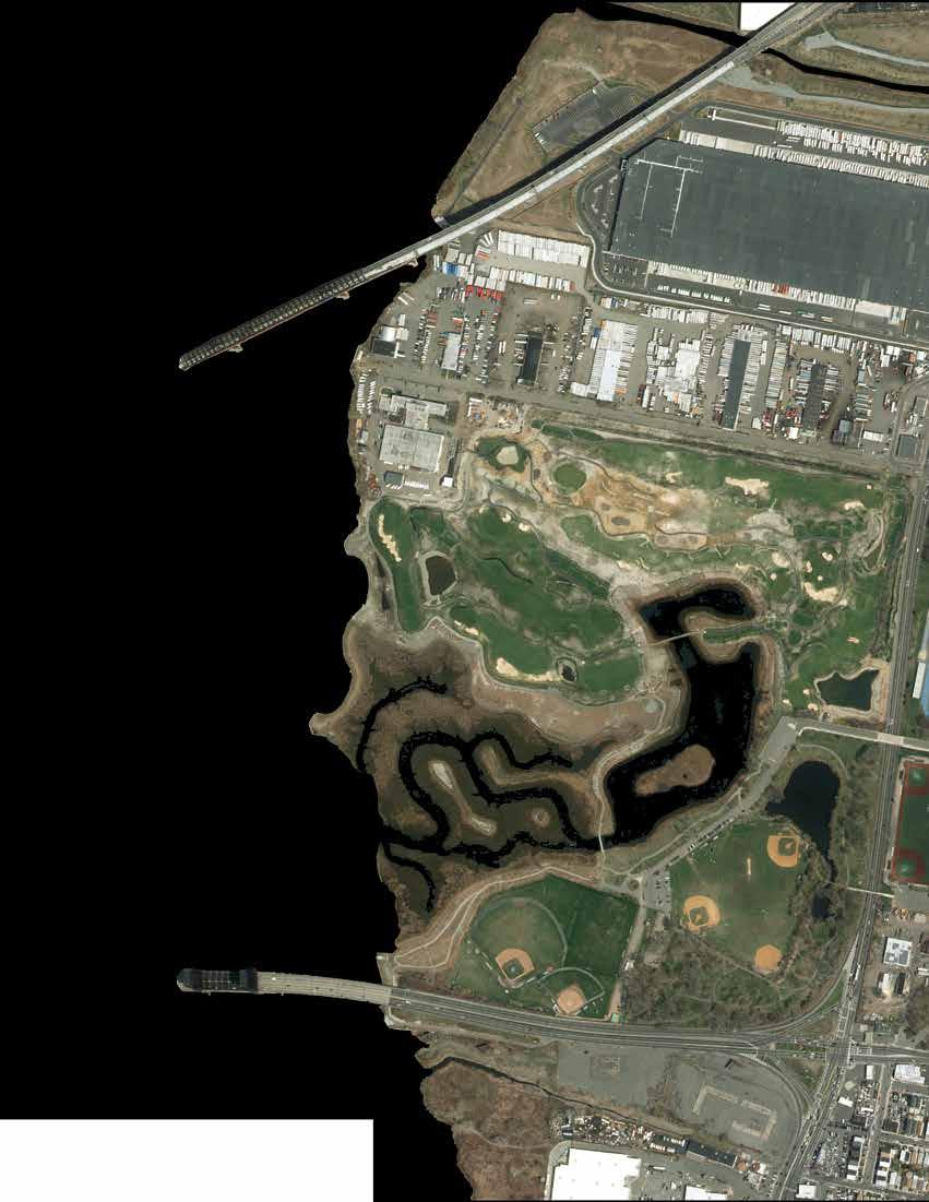
Welcome to the Hackensack River! You are invited to discover one of the premier natural assets in the northern New Jersey region. As the Hackensack River flows southward into the tidal waters of Newark Bay, for over 19 miles, it forms the western bank of the Bergen Neck Peninsula in Hudson County, New Jersey. Enjoy cool coastal breezes, scenic views, and maybe spot an egret resting along the riverbank.
You will find a mix of beautiful homes, shopping centers, railroads, majestic bridges spanning the river, and warehouses and businesses driving the economic engine of the metropolis. You will also experience boat launches, parks, restored environments, and preserved natural wetlands. In some areas, you’ll feel connected to the energy of the urban center. In others, you’ll enter a natural world and be immersed in a vibrant ecosystem, encounter wildlife in their native habitat, where you may forget you are encircled by development.
This plan will serve as your guide to exploring and navigating the Hackensack River waterfront. It details the full length of the Hackensack Greenway, a publicly accessible trail along the river. While portions of the trail currently exist, and are served by a variety of amenities and connections, others face significant obstacles for completion. The Hackensack Greenway Plan describes current conditions, connections to nearby landmarks and destinations, both short and long-term opportunities, and identifies gaps and challenges.
The intent of this plan is to inspire a greater connection with the Hackensack River and to envision the possibilities of expanding and enhancing the Greenway. Through a collaboration between local governments, non-profit organizations, private business, residents, and property owners, we can further protect, preserve, and expand the access to the waterfront for everyone.
Enjoy your time on north Jersey’s “Green Coast”!
quality of trail is sufficient for
primary connections that will create a multi-jursdictional Riverwalk note: proposed trails do not specify material
quality of trail is not adequate for bike and pedestrian use
connections that will create a multi-jursdictional Riverwalk, but are not optimal for bike and pedestrian use
Each section number is accompanied by an overview of the Hackensack Riverwalk. Know where that section is by looking for the highlighted portion of the trail.
Sub-section C
Sub-section B
A
secondary connections that will create a multi-jursdictional Riverwalk, but have extensive obstacles to completion. note: possible trails do not specify material
Section 1
The sections work their way up the Hackensack coast, starting on the southern tip of Bayonne and working north towards Secaucus.
Many sections will go in further detail, explaining details of the Riverwalk by sub-section, which also work their way south to north within each section.
Trail constructed of wood planking, usually over wetlands or the river
Trail constructed of a mixture of small stones and pebbles with sand
Trail consist of a paved surface separate from that of a driving lane
Trail consist of a cement surface
Trail constructed of brick pavers, assembled in pattern
Trail is adjacent to roadway, with a primary pedestrian focus
Trail consist of a combination of the above materials, such as an arrangement of pavers and cement blocks
The Hackensack River extends 34 miles (54.4 kilometers) from Haverstraw, New York to Newark Bay. Its watershed covers 202 square miles (523.2 square kilometers). More than half (58%) of the watershed is in Bergen County, around one-third (32%) is in Rockland County, New York, and the remainder (10%) is in Hudson County, New Jersey. The watershed is divided by the Oradell Dam into two major portions: the tidally influenced lower watershed, primarily the Meadowlands; and the upper watershed, which is not tidally influenced and is less developed. A total of 39 species (9 plants, 1 insect, 1 mollusk, 1 fish, 1 reptile, and 25 bird species) that are state-listed as being endangered or threatened in New Jersey live in the watershed. These include the bald eagle, the dwarf wedge-mussel, the short-nose sturgeon, and the bog turtle.


Over the past two centuries, the Hackensack River Meadowlands has been in state of constant transition. After sparse settlement by initial European colonists throughout the former lands of the native Lenape, the scale of human immigration and activities began to exponentially increase from the 19th century onwards. The Industrial Revolution and land development provoked rapid transformation throughout the Meadowlands as the ecosystem’s natural resources were extracted and modified by the growing population. Industrialization was a foundational part of the modern American economy but it also initiated the eventual neglect and degradation of the Meadowlands from pollution and industrial waste which had made large swaths of the river and surrounding environment nearly inhospitable for animal and human life.
However, in late 1960s, these trends became an issue of growing concern among the public, who to this day, continue to support direct intervention on the part of the government to remediate and restore the land. In 1969, the Hackensack Meadowlands Development Commission was established; its main responsibilities were to implement plans and regulations concerning land-use planning and zoning controls, solid waste management, and the study and protection of the environment. The Commission is composed of seven members appointed to five-year terms by the Governor: three each from Bergen and Hudson Counties, and the Commissioner of Community Affairs. In addition, the Hackensack Meadowlands Municipal Committee acts in an advisory capacity to the Commission, consisting of mayors and chief elected officials of each municipality that review major activities, including codes and standards, master plans, amendments, and redevelopment plans. The Hackensack Meadowlands Development Commission led local stakeholders in efforts to preserve critical natural areas, close and cap landfills, educate the public on the area’s environmental significance, and encourage recreation.
In 2015, the Hackensack Meadowlands Agency Consolidation Act was passed. The Hackensack Meadowlands Development Commission and Municipal Committee were absorbed into the New Jersey Sports and Exposition Authority (NJSEA), and the former was renamed the New Jersey Regional Commission (NJMC). The bill’s purpose was to “more effectively address the modern needs of the Hackensack Meadowlands” and “to promote efficiency of operation, cost effectiveness, and the elimination of unnecessary government bureaucracy.” Today, the NJSEA has jurisdiction over 19,485 acres (more than 30.4 square miles) encompassing 14 municipalities within Bergen and Hudson County. Continued stewardship by local governments, non-profit organizations, and the public will further advance the success story of environmental recovery and careful balance of active use and preservation into the future.


Bergen Point: An area in the midst of change, Bergen Point to Elco Boat Basin is dominated by former Texaco Refinery Site. IMTT and other industrial and commercial landholders occupy the reminder of the section.
• Collins Park as a starting/ending point of the Hackensack River Greenway

• Adding signs that designate start of Greenway (with consistent design along the entire Greenway) and connection to Hudson River Waterfront Walkway
• Work with developers of the Texaco Site to provide a functional walkway/bike path that will tie into the one at Collins Park
• Resurface walkway behind the Planet Fitness (former A&P site)
• Include a requirement for the construction of the Greenway in all redevelopment plans. Work with developers to include construction of Greenway at all waterfront redevelopment sites.
• Redevelopment of former A&P site into 17 acre mixed-use Bayview development will create enhanced waterfront walkway

• Texaco redevelopment may take 10+ years
• IMTT stores over 16 million barrels of petroleum products and may have security concerns with a walkway
• Vacant industrial properties may require remediation

1C - Old railroad historic district is in need of interim repair. Redevelopment into 17-acre mixed-use Bayview development underway.
1B - Security concerns may arise as this subsection undergoes remediation and redevelopment
1A - Redevelopment of the former Texaco site offers the opprtunity to connect the Hackensack River Greenway to the Hudson River

Downtown Bayonne:
From Elco Boat Basin to City Park (23rd St), this section is characterized by residential development. Existing walkways serve the southern and northern portions of this section. However, much of the central portion is developed with single family homes right up to the bay’s edge.

• Increase signage for the section of walkway behind Boatworks
• Make repairs to walkway at W 21st Street next to and behind apartments, also add benches to the wide section along segment facing west on the waterfront


2C


• Elevated boardwalk next to existing homes built to water’s edge that connects to City Park
• Extend 16th Street walkway south to the Robbins Reef Yacht Club and provide access to adjacent streets
• Plan to extend City Park walkway north along shore to provide connection to existing short segment at W 21st Street
• Homes are built right to the edge of the water and there is a high, steep drop to water
• The Robbins Reed Yacht Club between 10th Street and Edwards Court presents a physical barrier and security concerns
• Possible conflict regarding responsibility for walkway maintenance


Midtown Bayonne:
From 23rd Street to south of Stephen R. Gregg Park, this section is dominated by Veterans Park and Bayonne High School. There are single family homes right up to the river’s edge.
• Extend Greenway on north side of Veterans Park to continue along water and connect to service road behind the high school
• Possibly enough room on access road behind high school for a dedicated walkway/bike path
3C - Private property will create an issue building to waterfront
• Gap between waterfront boardwalk (part of $1M grant) behind the Sunset Bay Mobile Home Park and walkway behind the Bayonne Housing Authority – add this connection
• Create shoreline/elevated walkway on water to bypass service road behind school

• Most of the Greenway between Veterans Park and Stephen R. Gregg Park would need to be an elevated boardwalk

• Making the connection from the Bayonne Housing Authority section to the proposed walkway segment behind the Sunset Bay Mobile Home Park would require acquisition since the Sunset Bay Mobile Home Park is built to the edge of the river


3B - Veterans Park walkway is complete
3A - A connection from new Veterans Park Walkway needs to be made around residences here to Housing Authority property.


Uptown Bayonne:
From Stephen R. Gregg Park to Rt. 440 at Richard A. Rutkowski Park, the majority of this section is spanned by two parks. This is the most complete section of the Greenway to date.
• Add bike lane to Avenue A as a temporary connection to park in southern part of section
• Connect residential area at the southern end of section to enhance park access via elevated boardwalk

• Redevelopment of Marist High School creates an opportunity for a connecting pathway to John F. Kennedy Boulevard, other Bayonne neighborhoods, and Mercer Park.


• Extension of Greenway in the southern portion of this section would likely have to be in the form of an elevated walkway

4B - Proper signage designating use would be benefitial for safety


Route 440:
From Rutkowski Park to NJCU Athletic Complex, this section is characterized by a segment of NJ Rt. 440, which runs alongside the Hackesack River with no pedestrian access.
Incorporate the Morris Canal alignment off-road alongside road complete
• Integrate Greenway into Rt 440 reconstruction project

5B - City of Jersey City Route 440/ Routes 1&9T Multi-Use Urban Boulevard and Through Truck Diversion Concept Development Study proposes bike path and sidewalk


• Many trucks use the shoulder of the portion of Rt. 440 as a rest area. Potential opportunity to coordinate on enforcement of stopping and standing regulations, as well as with DOT to build a small rest stop nearby. This could allow for conversion of the shoulder into a protected walkway in the future.
• Future reconstruction of NJ Turnpike Extension Bridge offers potential opportunity for more public space below the bridge.
• Rt 440 is built right to the edge of the river leaving little or no room for a walkway on land
5A - Trucks frequently observed parking in shoulder of Route 440 adjacent to Hackensack River. Preventing this practice could open up the potential of using space in the road shoulder for a pathway connection.


Society Hill:
From NJCU Athletic Complex to the Bayfront Planned Development at Kellogg Street, Majority of this section is comprised of gated community Society Hill/Droyers Point. Bayfront is in the planning stage of redevelopment.

• Recently repaired walkway at Society Hill is vulnerable to storm damage. Public can maintain a dialogue with owners regarding conditions and maintenance needs.
• Incorporate waterfront access in the NJCU Gerrity Complex rennovation. The Gerrity Complex is included in Phases 2 and 4 of the NJCU Recreation Expansion Project.
• Make the entrance to Society Hill much more friendly to the public, current signs are very discouraging
• Keep gate to walkway at Society Hill open, not only unlocked, during the day
6B - Plan for more than 8,000 units of residential housing (market rate and affordable), open space, retail shops and other commercial properties, as well as boat landing and an extenstion of the HudsonBergen Light Rail at 95-acre Bayfront site.
• Look into Morris Canal Greenway alternative route overlaps to avoid Rt. 440 and connect to society hill AND/OR Create a walkway at the back of the NJCU athletic facility next to the river. NJCU is actively pursuing inclusion of a walkway in the redesign of their facility.
• Work with developers of Bayfront to seamlessly connect Society Hill Walkway section to new development

• Who is responsible for the Society Hill section of the walkway?
• Bayfront is a long term project. Site purchased by Jersey City in 2018. Redevelopment Plan adopted in 2021. Development anticipated to progress in phases. Construction expected to begin late 2022.

• It is recommended that any redevelopment plan include waterfront access consistent with the existing design standards at Society Hill and Droyers Point.
6A - Recently repaired walkway safe for pedestrians and cyclists.
Bayfront Development/Hudson Mall: From Bayfront Development to Lincoln Highway Hackensack River Bridge, this section has no completed Greenway. Characterized by redevelopment areas and retail -- Bayfront redevelopment site on the south and the Hudson Mall in the north.

• Create an interim walkway behind the Hudson Mall. Paved area for parking/loading has low traffic volumes and is wide enough to accommodate a path.
• Remediation by Honeywell is underway for properties south of Route 1&9/Communipaw Bridge. No plan is formally in place for these parcels, but there are multiple opportunities with City- and County-owned land adjacent to the waterfront along Communipaw Avenue. Can provide link for a southern expansion or connection to Lincoln Park and walkway.
• Connect Society Hill to the Hudson Mall through the redevelopment of the Honeywell (Bayfront) property
• Potential future redesign of Rt. 440, as well as vacant properties in this area, offers possibilities for additional Greenway connections and open space.
• Extension of the Hudson/Bergen Light Rail (HBLR) into the Bayfront Development would provide an East/West connection for the Hackensack River Greenway.

• Timing of redevelopment
• Hudson Mall walkway might require removal of a fence (possible security issue?) and must accommodate existing CSO


7B - Hudson Mall service parking and overgrown foliage dominates the riverfront behind the mall.
Recommend preserving the wetland area behind Hudson Mall as permanent open space.
7A - Plan for more than 8,000 units of residential housing (market rate and affordable), parks, retail shops and other commercial properties, as well as a boat landing and an extenstion of the HudsonBergen Light Rail at 95-acre Bayfront site.
Construction to begin in 2022.


Lincoln Park West:
From 1&9 Truck Hackensack River Bridge to Skyway Park, nice, natural Greenway through restored wetlands in Lincoln Park West. Ends by Duncan Avenue Garage. The northern portion is privately owned and maintained.
• Under the Route 1&9 Truck bridge, coordinate with the state to make connection to Lincoln Park West (connect this to city owned wetlands behind Hudson Mall).

• County-owned property at the garage at Duncan Avenue. Duncan Avenue has become a County road.
8C - County contracting professional services to design portion from West Lincoln Park to Duncan Ave.
• Gravel should be maintained as to prevent mud build up.

• Ensure connections are made if and when there is 440 and 1&9 Truck Intersection realignment
• Incorporate the Bike JC Master Plan
• Redevelopment of Hudson County garage on Duncan Avenue; County contracting for concept design of Greenway segment on the property
• Private ownership of trucking facilities north of Lincoln Park West.
• Underneath Pulaski Skyway poses issues of jurisdiction and safety (while the Skyway is undergoing rehabilitation.

8B - Continue gravel pathway and seating areas north, beyond the golf course.
8A - Connect Lincoln Park to south of 1&9 Truck with a walkway under the bridge overpass.
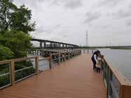
Skyway Park:
From Skyway Park to former PSEG facility, this section includes warehouses and vacant land.
• Skyway Park development will begin construction in 2022. In addition to the sweeping views of the waterway, as well bridges, highways, and rail lines that surround it, park visitors will find a pedestrian bridge, a pollinator garden, 502 trees in honor of Jersey City residents who passed away during the early days of the COVID pandemic, and a waterfront walkway. Walkways in the park will facilitate the connection in this area.
• Connecting short sections of walkways behind warehouses

• Agreement with property owners to preserve right of way for connection from Broadway beneath rail lines and NJ Route 7 to Duffield Avenue
9C - Connection from Broadway beneath rail lines and NJ Route 7 to Duffield Avenue is possible. Access agreements would be needed with I.W.S. Transfer Systems, Conrail, and NJDOT.
9B - This section should be developed in accordance with the Jersey City Redevelopment Plan.
• Connect existing walkways to Skyway Park
• Proposed redevelopment plan adjacent/north of Skyway park. The City could work with the developer on an agreement to have them build/maintain a portion of the Greenway there.
• Bridge connection over the tidal inlet, bringing the connectivity in this area closer to the riverfront
• Parcel ownership and safe public access points
• PATH rail line, freight rail line, and new Wittpenn (Route 7) Bridge present obstacles

9A - Development of 32.5 acre Skyway Park to create publicly accessible open space with Greenway.


(Concept plan December 2020, subject to change)
Proposed Possible

Path Status Material
Good condition Asphalt
PulaskiSkywayI-9


• New Jersey Sports and Exposition Authority Redevelopment Plan for PSE&G Hudson Generating Station site requires publicly accessible walkway through site.
• Route of connection between Duffield Avenue/Van Keuren Avenue and former PSE&G property to be established.
SECTION DESCRIPTION


PSE&G:
From Wittpenn Bridge to former PSE&G Hudson Generating Station Coal Power Plant site
• Developer of former PSE&G site seeking land use approvals to construct warehouse distribution facility. Coordination with developer is necessary for inclusion and routing of public access walkway.

10B - The now-retired PSE&G site will link Jersey City’s Greenway with segments in Secaucus.
• Legacy infrastructure on PSE&G property along shoreline requires deviation of Greenway from waterfront.
• Coordination with redeveloper for construction of Greenway on their property
• Safe access points and intersection crossings
10A - Safe, shared onroad access would need to be established for both commercial properties and Greenway users.
PSE&G Redevelopment Site
Path Status
Proposed
Possible
Proposed Roadway Realignment
Little Snake Hill: From PSE&G Coal Plant to Lewandowski Hackensack River Bridge, this area is dominated by coastal phragmites wetlands.
• Preserve exisiting railroad right-of-way
• Keep right-of-way clear of overgrown vegetation
• Repave existing paved right-of-way

• Access agreement with Amtrak for use of right-of-way below Portal Bridge approach
• Reuse of former rail line through conversion into EssexHudson Greenway. Hackensack River Greenway would connect and likely share right-of-way in this section.
• Work with Amtrak, NJ TRANSIT, other entities, to ensure rightof-way access as part of Portal Bridge reconstruction project.
• Former landfills have not been closed and capped
• Critical to preserve right of way for Greenway if development occurs
• Proposed 3,000 car parking lot on the old Malanka Landfill may have uncertain impact on right-of-way

11A - EssexHudson Greenway and Hackensack River Greenway to share rightof-way along former rail line in this section.
Path Status
Proposed
Possible


Laurel Hill Park:
From Lewandowski Hackensack River Bridge at Laurel Hill Park to County Road Ext. This area is dominated by the park and Xchange at Secaucus Junction.

• Install benches along walkway behind Xchange at Secaucus Junction
• The County received a 2017 Green Acres grant for improvements at the Park, which includes the restoration of a living a shoreline and the installation of a kayak launch
12E - Inconsistent paver colors should be avoided in trail expansion.

12D - New, wide walkway at Xchange at Secaucus Junction can be improved with seating.
• Essex-Hudson Greenway project will create 9 mile regional pedestrian and bicycle connection through rails to trails conversion. Reconstruction of bridge over Hackensack River will be necessary in this segment.
• Elevated walkway through wetlands along river, which is already on the ROSI for conservation purposes
12C - Boat dock provides recreational opportunity.
• Create an opportunity for students of High Tech High School to commute off road
• High costs associated with a long elevated walkway
• Redesign of County Road Extension to accomodate bicycle and pedestrian use with existing truck traffic
12B - Paved walkway, 5 feet wide, cracked.
12A - Wooden walkway over Hackensack River.


• Explore use of Meadowlands Parkway as detour, though bridges are narrow. Reconstruction of Meadowlands Parkway bridge over rail line, Secaucus Road, and Hackensack River inlet by Hudson County to potentially include pedestrian and bicycle component.


Anderson Creek Marsh:
From County Road Extension to Harmon Cove. This area is dominated by coastal marsh behind several industrial parks and is generally not accessible to the public.
• Elevated walkway through wetlands along river
• NJSEA District Transportation Plan calls for development of bicycle lanes on Seaview Drive- potential additional future connection
• High costs associated with a long elevated walkway

• Marsh is bisected by major rail line, possible security concerns and additional construction costs


13A - Difficult connection between County Rd. Extension (pictured) and Meadowlands Pkwy, railroad tracks separate potential sections
Path Status
Proposed
• Extend bike lane on Meadowlands Parkway south to Harmon Cove


Meadowlands Parkway South: From Harmon Cove to Harmon Plaza Road. This area is dominated by Harmon Cove, a private residential development.

• Town could fund walkway at Harmon Cove, developer would need to provide public access to Harmon Cove

• Would Harmon Cove grant public access to property?
• Limited, or in some cases, no space to construct Greenway on land at Harmon Cove
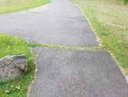
14C - Inconsistent materials connecting segments around Hudson Regional Hospital
14B - Short bicycle lane on Meadowlands Parkway (pictured) should be extended

14A - No sidewalks along Meadowlands Parkway on elevated section leading to bridge
Proposed


Good Condition
Path Status Material
Gravel
Meadowlands Parkway North: From Harmon Plaza Road to Trolley Park, this area is dominated by residential development on the waterfront. It includes two hotels and a large vacant lot owned by Hess.

• Extend Meadowlands Parkway bike lane north
• Add signs directing the public to the parking lot just before Riverside Court
• Redevelopment of former cement plant to 116 unit residential building on Paterson Plank Road next to Trolley Park to preserve section of walkway along the river


15C - Portion completed
15B - Attractive, existing signage for Greenway installed

• Elevated boardwalk through wetland areas connecting Snipes Park with Hess Property, potentially beyond
• Greenway through Hess property (potential for future redevelopment)
• NJSEA District Transportation plan identified long-term project goal to construct pedestrian/cyclist bridge from Paterson Plank Road to Carlstadt
• Potential access issues, security concerns, with Greenway under the Route 3 East and West Bridges
• New walkway at cement plant site residential development on Paterson Plank Road should be consistent with design standards, branding, and signage of other Greenway segments.
15A - Red Roof Inn has pavilion along a short portion of a walkway along the river.
• This section is largely complete. Creation of alternative route to connect with next section will require significant effort, thus no short term opportunities are recommended. Short term focus should be on maintenance.

Mill Creek West:

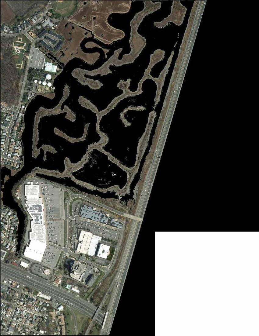
From Farm Road Park to Millridge Road, this area is characterized by waterfront parks, natural wetlands, and includes Secaucus High School. This is close to the northernmost extent of the Hackensack River within Hudson County.


• Pursue identification, acquisition, and development of off-road trail as alternative to Millridge Road/Koelle Boulevard through residential neighborhood to connect Mill Creek Point Park and Mill Creek Marsh.


• Flooding from storm events and long term sea level rise supports permanent preservation as natural, open space, but threatens location and condition of Greenway and surrounding facilities and residences.

• Provide access to Mill Creek Park via the shopping center on Park Plaza Drive, currently the gate is locked

• Extend walkway on Millridge Road to continue on Koelle Blvd


Mill Creek East:
From Mill Creek Point Park to Mill Creek Park at Park Plaza Drive, the most natural section of the Greenway
• Build a short pedestrian bridge to connect Koelle Blvd (via Huber Street) to existing trail at Mill Creek Park


• Pursue identification, acquisition, and development of off-road trail as alternative to Millridge Road/Koelle Boulevard through residential neighborhood to connect Mill Creek Point Park and Mill Creek Marsh.
• Cost of elevated bridge
• Respect concerns of residents along Huber Street and Koelle Boulevard
• Possible safety concerns where gate is locked?
• Primary access point without a car is only from the northwest at the high school


Justified by the lack of connections from Secaucus to the Tonnelle Avenue Light Rail station, the NJSEA recommends constructing a dedicated pedestrian/cyclist bridge/boardwalk between the Tonnelle Avenue Light Rail station to Park Plaza Drive in Harmon Meadow East. This project could also accommodate light/smallscale Automated Vehicle (AV) deployment. By creating this connection, there would be better transit access to and from this employment center.

This connection to transit will serve the Hackensack Greenway, particularly those whose origin or final destination is not along the route.
The Hudson-Bergen Light Rail primarily runs along the eastern portion of the county. An extension of the West Side Avenue line will bring the HLBR to the Hackensack Greenway. There may be additional opportunities in Bayonne to connect light rail to the Hackensack waterfront.
Safe access to/from NJ TRANSIT’s Secaucus Junction is another priority of the NJSEA. The commission recommends bicycle lanes along Seaview Drive to the portion of the walkway along Meadowlands Avenue. There may be additional opportunity to connect users to the Greenway with a connection to nearby Laurel Hill Park.
Having multiple modes of transit will increase recreation and commuting opportunities for those who may only desire to use the Greenway one-way or if inclement weather is present.
For residents and visitors who will use personal vehicles to access the Greenway, consideration should be given to public parking. Existing lots at transit stations may be able to handle additional capacity for Greenway visitors, especially during off-peak hours. EV charging should be considered as well.
Source: Meadowlands
District Transportation Plan 2045, NJSEA

Path Status
Good Condition
Proposed
Potential
These design standards are intended to serve as guidance for walkway construction and maintenance, reflecting best practices for specifications and features. Installation and maintenance will require a collaboration between various property owners, governments, agencies, and other stakeholders.
An off-road pathway running parallel along the water’s edge is always preferred where feasible.
• The pathway, and all sidewalks, crosswalks, and curb ramps, as well as the materials from which they are constructed, should comply with ADA standards.
• The pathway should be paved with either asphalt or concrete. When feasible, permeable pavements are encouraged.
• Pavers may be used for decorative accent purposes such as border areas or amenity spaces.
• For portions over water, a pressure-treated timber or composite boardwalk should be installed. The direction of the wood should not be parallel to the direction of traffic to limit the possibility of splinters. Transitions between paved and boardwalk portions of the pathway should maintain a level surface for safety and comfort for rolling wheels.
• All surfaces should be textured to avoid the potential for slipping.
• Where necessary, surfaces should be designed to support the maximum load anticipated for vehicular traffic, such as maintenance vehicles or fire equipment.
• Where feasible, the preferred pathway width should be 18’ to allow for two-directional pedestrian and bicycle traffic.
• Pavement markings should be used to indicate directionality of traffic and division of bicycle and pedestrian spaces.
• To allow for passing without conflicts, no less than 12’ width is recommended for any section of the paved pathway.
• Where possible, an additional 4’ of easement is recommended on either side of the pathway as a buffer to allow for vegetation. Where space is constrained, the buffer is more important on the land side, as providing a vegetated buffer between neighboring properties and streets while maintaining views of the river is the priority.
• Amenity spaces, such as seating areas and plazas adjacent to the pathway, are encouraged throughout the length of the Greenway.
Where existing land uses and/or terrain do not allow for the creation of a pathway directly adjacent to the water, an on-road pathway offers an interim solution.

• The pathway, and all sidewalks, crosswalks, and curb ramps, as well as the materials from which they are constructed, should comply with ADA standards.
• Pedestrians may use sidewalks. Separated, protected bicycle lanes designated with pavement markings are preferred. At a minimum, sharrows should be included in the roadway, with accompanying roadside signage designating the Greenway and bicycle route.
Vegetation has numerous benefits: it provides a visual and audio buffer from the surrounding urban context, improves the aesthetic appearance of the Greenway, helps to absorb stormwater, and provides a habitat for wildlife.
• Native, riparian, urban-tolerant plants and trees should be used.
• Smaller-scale plantings should be used directly alongside the water to prevent obstructing the view and minimize required trimmings.
Amenities may serve to enhance the experience of users along the Greenway.
• All amenities should be made of high-quality, durable materials that are suitable for the marine environment, tamper and graffiti resistant, with a long lifespan and minimal periodic maintenance. All amenities placed within the 100-year flood plain must be designed to withstand flood conditions.
• Seating should be provided along the pathway and in adjacent plaza spaces. Seating types may include benches and wall seating.
• Trash receptacles should be placed along the length of the Greenway. Additional trash cans shall be provided as necessary at plazas, gathering places and near concessions and retail uses which generate trash. Trash receptacles should only be installed if a program is in place to consistently empty them.
• Bicycle parking should be provided along the Greenway, particularly at plazas, parks, and connecting walkways, to allow for bicyclists to stop and relax and to discourage the use of the handrail, benches, or trees as fixtures to which bicycles may be attached. Bike racks should be securely mounted, either embedded in concrete or surface mounted with tamper-proof hardware. Racks should provide two points of contact to allow a bicycle to be locked with a U-lock to the frame and one of the wheels. Bike lockers may also be considered for locations where longer-term storage may be desired.
• Lighting may be used to facilitate early morning and evening use of the Greenway. Lighting is also recommended in areas where natural light is limited such as underpasses. Lighting fixtures should be of a consistent design and color and complement the design of other amenities and signage. Lighting should be pedestrian scale, and fixtures should be cut-off to limit light pollution.
• Drinking fountains are encouraged in amenity spaces.
• Consideration should be given to creating a sense of place in plazas and amenity spaces through the design, colors, and materials of amenities, as well as the inclusion of public art.
Signage with a consistent design should be used along the Greenway to provide directions and information.
• Signs should be located where most effective in terms of decision points and informational needs. They should be located for prominence and readability. Whenever possible, simple graphic symbols should be used in place of text, as they are easily identifiable can allow for understanding by users with language barriers.
• To promote branding and recognition, a visually consistent graphic design theme should be used on all signage throughout the Greenway, with an established typeface, fonts, and color palette. A primary logo for the Greenway should be designed and used across signage. Additional logos may help with highlighting specific features or themes. Signs should maintain consistent shapes.
• Where applicable, signage directing Greenway users to publicly-accessible restrooms should be placed along the pathway.
• The order of messages on signage should be kept consistent along the length of the Greenway. Messages at the top of signs should relate to the most immediate points of decision, such as turns, and messages for users not making a change should be lower. Closer destinations should be higher while the furthest points should be at the bottom.
• Directional signage should be provided to all intersecting or nearby trails, nearby parks, plazas, transit stops, and other public areas, including distances and/or walking times, where applicable.

• Distance markers should be placed along the length of the Greenway at an interval of every 1/10th of a mile, where feasible. The markers should integrate the logo and Greenway colors to help users confirm that they are on the Greenway.
• Wherever the pathway intersects with a roadway, advance warning signs should be placed on both the pathway and the roadway.
• Interpretive signage at select locations can highlight points of interest and promote education about the natural environment.
• Maps and directories can highlight nearby business districts. Any maps should be oriented so that the top of the map is the direction the viewer is facing.
• Gateway signs marking entry points can help raise interest in the Greenway and promote its identity and use. They should be large enough to be seen from a distance.
• Space can be reserved for changeable signage such as decorative seasonal banners and signs to promote special events
• Any necessary regulatory signs should maintain consistency with the overall graphic design theme.

Supporters should encourage the formation of a Hackensack River Greenway Working Group, comprising local officials, community organizations, property owners, and residents, with representatives from the County and each municipality, to plan and advocate for the Greenway.
Working with private property owners and municipal staff, the Working Group would advance the completion of the Greenway. The Working Group could promote the Greenway to users and to policymakers and funders.
The Working Group could discuss issues affecting the Greenway and help achieve resolutions. The Working Group may set design standards and review proposed installations for consistency. The Working Group could coordinate maintenance and upgrades. The Working Group could also help to organize and sponsor special events on or along the Greenway.
