Scholes Junior and Infant School
Geography Disciplinary Knowledge Progression
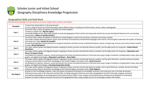
Geographical Skills and Field Work
Red denotes knowledge from the National curriculum taught within another area/subject
Reception
Year 1
Year 2
To draw from observations in the environment.
To use a range of resources to find information about different places, including non-fiction books, stories, videos, photographs.
Use world maps, atlases and globes to identify the United Kingdom
To devise a simple map. (Big City Lights)
Use simple fieldwork and observational skills to study the geography of their school and its grounds and the key human and physical features of its surrounding environment. (Where is Scholes School?)
Use world maps, atlases and globes to identify the United Kingdom as well as the countries, continents and oceans studied.
Use simple compass directions (North, South, East and West) and locational and directional language (near and far, left and right) to describe the location of features and routes on a map. (Beside the Seaside)
Use aerial photographs and perspectives to recognize landmarks and basic human and physical features, devise a simple map, and use and construct basic symbols in a key. (Nurturing Nature)
Year 3
Year 4
Year 5
Year 6
3
Use maps, atlases, globes and digital/computer mapping to locate countries and describe features studied. Use the eight-points of compasses. (Active Planet) (Yorkshire)
Use maps, atlases, globes and digital/computer mapping to locate countries and describe features studied. Use the eight-points of compasses. (Mountains and Rivers) (European Study)
Use fieldwork to observe, measure, record and present the human and physical features in the local area using a range of methods, including sketch maps, plans and graphs, and digital technologies. (Mountain’s and Rivers – River Walk)
Use maps, atlases, globes and digital/computer mapping to locate countries and describe features studied. Use four-grid references, symbols and key (including ordnance Survey maps) to build their knowledge of the United Kingdom and wider world. (South America)
Use fieldwork to observe, measure, record and present the human and physical features in the local area using a range of methods, including sketch maps, plans and graphs, and digital technologies. (Farming Comparative Study)
Use maps, atlases, globes and digital/computer mapping to locate countries and describe features studied. Use six-grid references, symbols and key (including ordnance Survey maps) to build their knowledge of the United Kingdom and wider world. (Polar Regions)
build on their knowledge of globes, maps and atlases and apply and develop this knowledge routinely in the classroom and in the field interpret Ordnance Survey maps in the classroom and the field, including using grid references and scale, topographical and other thematic mapping, and aerial and satellite photographs use Geographical Information Systems (GIS) to view, analyse and interpret places and data use fieldwork in contrasting locations to collect, analyse and draw conclusions from geographical data, using multiple sources of increasingly complex information.
Key Stage