J. Sawyer Davies | 704.649.5603 | jd8wc@virginia.edu
UVA School of Architecture | Charlottesville, VA | 2024-Current Lecturer
Education
University of Virginia School of Architecture
Charlottesville, VA | 2015-2018
University of Virginia School of Architecture
Charlottesville, VA | 2020-2024
Master’s in Landscape Architecture and Architecture Experience
Taught two design studios simultaneously for both graduate and undergraduate students ,and a third graduate architecture studio. All three studios feature hybrid projects that engage spaces with complex histories, publics, and ecologies bringing together techniques and methods from both landscape and architectural pedagogy. Teaching portfolio available upon request.
D.I.R.T studio | Charlottesville, VA | 2025-Current Landscape Designer
Worked on large private residential project to design series of liminal and recreational spaces. Drafted plans, sections and other drawings for construction administration including complex grading plans. Collaborated with architects working on additions to the residence.
Coordinated with a multidisciplinary team including landscape architects, data scientists, and engineers to develop remote sensing and identification of vegetation through hyper-spectral imagery to enable at larger scale nature based infrastructure management practices. Developed a book for publication including layout, graphics, and text.
Andrea Cochran Landscape Architecture | San Francisco, CA | Summer 2022 Intern
Designed and visualized landscape projects consisting of high-end residential, city parks, and hospitals. Designed custom pavers and wrote script in CAD for hospital rooftop landscape. Analyzed LEED requirements. Generated site sections for residence in Texas and rendered new site plans. Created custom bench models for high performance concrete furniture installations.
Wolf Josey Landscape Architects | Charlottesville, VA | Winter 2022 Extern
Worked on UVA’s Tree Master Plan for the Rotunda area of grounds, produced an axonometric diagram of the site to categorize tree typology in relation to view. Responsible for generating topography models for this project and a local farm compound in Crozet, VA.
Bachelor’s in Urban and Environmental Planning
Skills Proficiency
Adobe Illustrator | Adobe Photoshop | Adobe InDesign | ArcGIS Pro | AutoCAD | Enscape | Microsoft Word | Microsoft PowerPoint | Lumion | Physical Model Making | Rhinoceros 3D | Sketching | French | Zoom
Working Knowledge
Adobe After Effects | Drone Photography | German | Grasshopper | Microsoft Excel | Midjourney | Revit | SketchUp | Stable Diffusion | Python
Cape Charles Stormwater Management Planning | Prepared and implemented a plan for economic, social, and ecological success in Cape Charles, Virginia. Consulted with local officials and community members.
Healthy Design Capstone | Studied the intersection of health and landscape/play-scape design in hospitals, schools, and rehab facilities.
University of Virginia | 2020-2024 | Teaching Assistant
LUNCH 17
University of Virginia | 2021-2023 | Editor
Section I: Sensitivity
01
Section II: Hybridity
06
Section III:
Section IV: Materiality
11
Section V:
In
01 MEANDER
a sequence of movement and bathing
Meander envisions a new bathouse sequence to envelope and redefine two existing historic bathhouses in Warm Springs, VA. This sequence is guided by the larger geologic spatial patterns of the Appalachian mountains , both geologically and ecologically. In a way, the ridges and tree lines of the region act as veils for the valleys they enclose, fostering a cinematic visual play as one moves along the main routes. Meander responds to these conditions by offering a way to interpret the land, while also letting the land interpret the design. This design comes in contact with the ground at the fewest possible points, utilizing a tension system to maintain a light touch. The position of these points is dictated by three rules. The first is to never interrupt the existing stream, the second is maintaining the spatial integrity of the existing bathouses by not coming within 20ft of them. The third is to connect existing clusters of trees to form a singular canopy form. This project is called meander because of these spatial shifts on both the horizontal and vertical plane -- the 90 degree turns force one to pause at key points, while repositioning the body up off the ground facilitates and encourages new perspectives. The program is very simple, only what is necessary for the maintenance and use of the baths is incorporated. A series of new outdoor baths is situated at the end of the sequence at the lowest part of the site, mirroring the process of water flowing downhill until collecting and remaining still -- a theme again reflected and abstracted in the movement through the project. Meander establishes a new sequence of movement and bathing, complicating and clarifying the relationship of the old baths to the landscape through framing, veiling and the position of the body.
02 CONVIVIAL TRAJECTORIES
friendship court streetscape redesign
03 SOCIO-ECOLOGICAL INFRASTRUCTURE
rhizomatic networks
Contextualizing Street Life and Social Infrastructure
Chabutra provide places of respite for birds, contributing to a multispecies public
Chabutra touch the ground lightly, allowing maximum space in the street, often the center of a
Stepwells provide critical hydrologic and social infrastructure
Noor Nagar - Accupunctural Network
This project seeks to create a network of critical infrastructure and space that legitimizes the daily life of people living in Noor Nagar, acting as a catalyst and end in itself. The infrastructures are carefully woven into the dense informal settlement, occupying where the domestic and public space begins to blur. While each intervention is carefully tailored, their strength is in functioning as a connected network.
The infrastructures are flexible in nature and aren’t over-programmed, but have the capability to be water access points, provide shade, illumination, waste collection and composting — and ultimately opportunities to extend the domestic space with cooking, laundry, and critically bathrooms. Inspiration was drawn from Mughal water management where water becomes the connecting tissue of social life and functions, the banyan tree, an immense canopy as a place to gather, and the chabutra where the idea of touching the ground lightly, providng habitat, and using plinths comes into play. In many quays this project is a re-translation.
01: Utility Canopy
02: Latrine Wall
03: Water Tower
04: Minimart
05: Unfolded ATM
06: Rest Stop
07: Chabutra Square
Sewer Line Waste Routes Water Line
The catalog illustrates prototypes of the intervention, with the utility canopy being one intervention and something as simple as a bench or water atm illustrating the breadth of interventions. The interventions act as orientation devices by their color, with the water towers capable of being seen throughout the village. Each intervention carefully mediates its connection to the ground through the use of brick patterns inspired by Islamic tile work.
Each infrastructure is connected through paved drainage systems as well as other material flows categorized on the previous page. The metal pipes, poly-carboante roofing, and fabric partitions can be assembled quickly but are not envisioned as temporary.
This project believes that a robust, elemental system of infrastructure and social space can provide the foundation for legitimate living and future change.
A place is not simply a network of pathways and structures to which they lead, but rather a complex landscape of topography, vegetation, history, race, and ultimately socio-ecological conditions. These conditions are embedded spatial figures and fields in the urban context. Here invisible and visible trajectories meet, weaving a complex narrative that is encoded in space.
This studio project explores the relationship of certain physical conditions and their relationship to race and wellbeing in the overall study of Charlottesville as a racialized topography. Urban canopy, southwest facing slopes, topography, and impermeable surfaces were all identified as fields that in isolation and in aggregate create unfavorable conditions for wellbeing. Charlottesville is situated in the piedmont region of Virginia, its most challenging season is the summer that brings intense, sweltering heat. All of the above conditions relate to the microclimatic conditions of spaces. A neighborhood that is situated on a ridge, with vast canopy coverage on a northeastern slope will experience this heat quite differently than a neighborhood on a south/southwest facing slope, with little canopy coverage and high levels of impermeable surfaces. Mapping these conditions and their intersections revealed vulnerable areas that correlated strongly with race, particularly the black population in Charlottesville.
The analysis of present day conditions was supplemented by a diachronic analysis delving further into the history of race and space of Charlottesville.
05 ROTUNDA TREE MASTER PLAN
view analysis and tree typologies
06 DISAGGREGATE repositioning the interstitial
By disaggregating program into narrow, separate and layered volumes interlaced with connecting bridges, stairs, and ramps – this project foregrounds the interstitial connective elements of the building, highlighting movement and allowing greater access to light, air, and visual connections. Disaggregate counteracts the typical relationship of structure to street in Fulton Market, instead offering a clear vocabulary of activity with open spaces for different degrees of gathering.
Layering the volumes and cladding them with facades of different opacities allows for variable levels of privacy and intricate visual relationships, especially in juxtaposition with the more open circulation corridors. A public plaza and rooftop garden act as dual attractors of movement in the central area of the design, while offices situated at each end of the project concentrate private work spaces. It is the this in-between condition that draws different users together and creates a dynamic workplace that refutes the physical and social bounds of the cubicle.
07 SPECULATIVE MANAGEMENT
alternative strategies in the chesapeake, positioning artificial intelligence
Speculative Management is a series of provocative explorations using Midjourney and Stable Diffusion to imagine extreme futures in the Chesapeake Bay. Text prompts were used to quickly develop ideas as an iterative dialogue rather than pursuing a final answer or deterministic solution, unpacking how management strategies could alter human relationships to the Bay. In many ways this exercise was about understanding the role that machine learning can have in the design process, especially in designing an experimental landscape. This project was coauthored by Charlotte Devine and Brianne Nueslein.
08 HYBRID PIERS
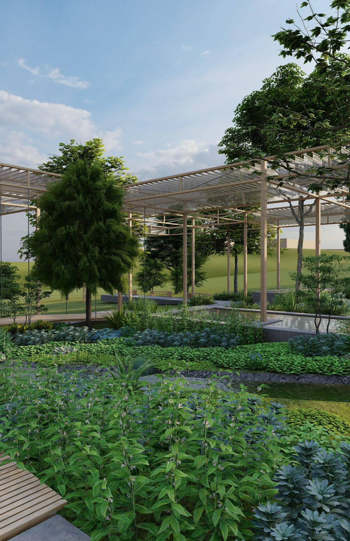
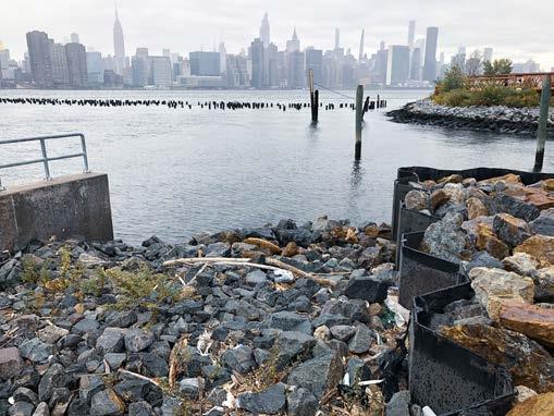
resituating manufacturing, housing, and ecology
This project seeks to interweave a hybrid manufacturing school and maker-space, social housing, and infrastructural park that redefines the relationship between the built environment and the east river socially, ecologically, and tectonically. Hybrid piers is grounded in a larger understanding of the city as topography and watershed. Early research was focused on the hydrology of the river, especially in relation to different storm events and climate change. In many ways the river and water itself is not confined to the thin boundary lines of edge, rather fluctuating and shifting, moving in and out of the city. On site, we were drawn to the industrial memory still persistent in Brooklyn. This project draws from typically industrial material such as corrugated panels, metal grating, and the typology of warehouses. The design proposes a structure that invites water into the site, and the public to the water, diffusing the boundaries between the two. By wrapping along the edge of the site and transitioning to the center, the building frames different spaces and offers a path to and from the water. Patterning of the city is embedded in the building as it shifts in scale to mediate relationships from the warehouse to housing tower along the edge of the water, responding as well to the spatial organization of buildings in the neighborhoods adjacent to the site. This morphological relationship is also embedded in the programmatic structure of the building, where the manufacturing space is concentrated at the base, the school weaves through the structure vertically, and exhibition, performance and gathering space is concentrated at the top.
Hydrological Context and Landscape as Infrastructure
The landscape design protects the building from tidal changes and storm events, functioning infrastructurally. Also, it provides opportunities for a variety of aquatic habitats, wetland levels that take advantage of variable inundation levels, and microclimatic experiences. Because there is no door to the threshold for these spaces, they are a constant link to the community.
Massing Studies
Housing is modular and screened by corrugated metal panels which are perforated and operable. Our non housing program features glass panels and mullions that relate to the pattern of the panels but act to visually interrupt them, clearly legible from the exterior.
Each unit features a semi enclosed solarium/balcony space opposite of the circulation corridor. The same linear banding that guides the form of the building is also applied to the modular unit design where movement occurs especially at the edges.
Typical Units
5F
Hybrid piers plays with the idea of piers that extend out into different territories, operating horizontally and vertically. The program of this project draws again from the history of production concentrated along the river’s edge, creating a high school focused on trade skills and manufacturing research. Additional makers spaces and manufacturing facilities are available after school hours and on a permanent basis for local companies that partner with the school. Exhibition and social spaces are a key component to the educational facilities and ultimate goal of providing opportunities for members of the larger public to participate. This project was coauthored by Blake Bissen.
CREATIVE COMMONS
AUDITORIUM + EXHIBITION
GREENPOINT LANDING EVENT PIER
09 CELEBRATION STEPS
highlighting uva’s black bus stop
Celebration Steps seeks to illuminate a historic space on the UVA grounds that has been appropriated by Black students, staff, and faculty as a place to gather, dance, rest, and find belonging in an otherwise unwelcoming social and physical landscape. The Black Bus Stop was no different from many of the other stops on grounds, rather it was chosen as a place to gather due to its central location -- an especially important physical space before other forms of communication rendered meeting elsewhere simpler. It is a place to see and be seen. A place claimed not given. This project explores the complex histories of the UVA Pavilion Gardens that sit next to the BBS as in-between spaces, drawing inspiration from the idea of in-betweenness both spatially and socially. The proposed design features a series of steps ascending what is currently a banal hill behind the BBS. Between these terraced steps are small planted gardens, while the steps themselves serve as places to perform and display not unlike a series of runways. The material language of the steps extends onto a paved plaza where changing paver frequencies and concrete bands reinforce the presence of the steps on what is a flat surface. Celebration steps draws from the notion of the bus stop as a place of identity, rest, and conviviality.
In-between Spaces
INBETWEEN SPACES
1920s Early Aesthetic Rennovations
Anna Barringer, dauther of a professor, initially described the enclosure west of Hotel F as a highly functional area: "The back yard was constantly crowded by these delivery men and a kitchen house with quarters above for the cook and family, a coal bin, a wood pile, a chicken coop, and a hydrant. These then were the essential components of a back yard..." Later, the arrival of indoor heat, plumbing, baths, and kitchens meant the disappearance of earlier landscape features like wood piles, chicken coops, and coal bins. Backyards were planted into edible and ornamental gardens and porches were added for outdoor leisure.
1950s: The Garden Club of Virginia projects an alternate version of pleasure gardens in pursuit of beauty.
Coed Room: A sanctuary for women starting in 1928 (1920 decision allows female graduate students). Bettie Slaughter aka. Bettie Co-Ed runs it for 33 years. She provides emotional and physical support, “an institution herself.” Mentor, friend, surrogate mother, and much more, Bettie supported white women in a university system that denied her access and visibilty as a black woman. Current location of west range cafe.
Early 19th Century: Gardens are utilitarian, often workyards or waste dump sites as much as they are used for domesitc kitchens.
“1935: Alice Jackson, from Richmond Virginia, and a graduate from Virginia Union University, applies for matriculation into the University of Virginia. She wanted to attain a master's in French. The Board of Visitors deny her application the NAACP tries to wage a battle with her case. They are unsuccessful at desegregating the University then, but have set a precedent to be followed fteen years later.”
Isabella Gibbons: 1850-1863, held in slavery, cook in pavillion VI. 1867, Awarded diploma from New England Freedmen’s Aid Society Charlottesville Normal School, she became a teacher. Earliest example of a woman teaching and learning at UVA.
10 VICENZA
drawing as a medium and a framework
11 MODULAR OFFICE DESIGN
yamanashi broadcasting center case study
This Section Model at 1/3” = 1’ scale seeks to characterize the relationship between the rigid vertical cores of Kenzo Tange’s Yamanashi Broadcasting Center and each modular floor. Here each floor cantilevers from a single cylinder structure, exposing the tectonic nature of the concrete construction. Below is an image courtesy of Architzer and a section traced over and modified from a base image courtesy of ArtStor.
12 PANEL FENCING
d.i.r.t studio | summer 2021
13 AXIAL MOLD
experimental casting with garnet
Using a 3d printed axial mold specifically calibrated to fit onto a rolling implement, a unique concrete panel was created. The roller mold plays with the idea of texture, and is inspired by the topographical condition of dunes. A concrete mixture was infused with garnet (a waste product of concrete disposal), mixed, and then finished with a top layer of garnet. This medium is what the 3d printed mold was rolled over to create a unique cyclical pattern. The addition of garnet into the casting process resulted in a dynamic and rich coloration that fades in certain areas and remains vibrant in others -- changing over time.
14 DRAWING WATER
sediment simulation and representational experimentation
This project was part of an elective course focused on representational techniques and technical understanding with focus on water. Pictured adjacent, a geomorphology table was used to simulate sediment movement in alluvial and coastal conditions. Plastics are color coded according to their weight and size, with a water outflow situated at one end of the basin. The table acts as a drawing itself, allowing water to determine the outcome. Various iterations were explored. Some focused on observing extremely gradual changes with a consistent river-like flow, while others focused on many iterations of wave conditions. Ultimately, various mesh configurations and devices were used to approximate the effect of submerged vegetation on sedimentation. During this process, I focused on observing specific sediment formations and documenting relationships. From this a particularly interesting form arose that became the basis for the final project. Experimenting with drawing techniques in a similar manner to Catherine Dee, the image was projected onto a wall and traced onto a 24” x 36” piece of paper with 7 different pencil line-weights. The finished drawing is an abstracted representation that questions scalar relationships and synthesizes several techniques in the hopes of generating new understandings.
15 IN-BETWEEN GARDENS
a reorientation of cultural landscapes
This project subverts the typical spatial organization of Los Angeles to create a new community art center for the Boyle heights neighborhood, drawing from notions of paradise, memory, and the everyday. Boyle Heights is a community of resilience and vibrancy, an epicenter of social activism and incredible art. A product of urban renewal practices, several highways both carve through Boyle heights and separate it from its surrounding neighborhoods. Boyle heights also faces pressure from art galleries and other opportunists seeking lower rents as they move from the center of LA. In-between gardens plays with this tension between connection and separation by rotating the typical grid structure 20 degrees to the north east. This rotation resists the determinacy of the grid and its streets, symbolically pulling away. At the same time, by rotating the project in exactly this manner, the corners of the most public (and commercial) streets open to pedestrians rather than creating barriers.
The buildings are made of a brick and timber structural system, where a double thick brick wall with rebar serves as exterior shear wall and the timber columns that branch out allow for subtle cantilevers and flexibility within the structure.
Each of the buildings are carved into and through by a series of gardens. These gardens serve as an ecological infrastructure in counterpart to the highways, offering a different way of creating space. These spaces vary from private working courtyards, dense chaparral plantings, plant sculpture gardens, and ultimately to a mosaic of different planting strategies that culminates in a central plaza with rooms defined primarily by the architecture of vegetation and treatment of the ground plane. Each brick represents a single unit that must correspond to the shift in the grid, further emphasizing the notion of this spatial re-orientation. The bricks are also simple to build with, and draw from practices in Latin America and Mexico.
16 SONIC RECALIBRATION
a spatial meditation
This project is audio-centric in nature, prioritizing the sonic experience and soundscape as the guiding element of design. Situated adjacent to a reservoir, and at an intersection between several edge conditions, the design responds to the innate sonic conditions and prevailing wind patterns in order to create the conditions for a meditative composition. Ground material, habitat, plant architecture, wind, water, and any number of combinations there-in serve as the instruments of the soundscape around which an experience is tailored. Cut into the ground, a path derived from the notion of the meditative maze provides a clear oscillating movement from out to in through a series of raised mounds. These mounds are arranged parametrically, with the largest mounds at the north east and south western area of the design (corresponding to the greatest wind velocity during the winter and summer seasons), receding as the user moves closer to the center until the path culminates in a deep depression cut into the earth, not unlike the journey experienced in the Japanese tea ceremony. Through the experience, visual inputs will be limited and frequently changed as different sonic experiences are highlighted in a journey that culminates in a reset, allowing a recalibration to greater awareness of the soundscape that is so often a background influence.
Sound is never pure, rather it is simultaneously an action and reaction. As users we impact the sound created in a landscape as we move through it. Our movement is an unavoidable interaction that necessitates contact with the ground, this interaction generates sound that changes with the ground material, but also with the amount of pressure with which our body meets the ground. This pressure changes with slope and so too does the noise produced. This can be expanded to look at rasised or sunken paths, stairs, other materials and footwear choice (as well as vegetaional and laerger landform considerations).
By creating four unique parts to the composition and encircling them, one can experience several parts all at once depending on how the other parts of the maze are activated based by users movement and wind conditions. This allows for greater control and variety than a linear path where there is less opportunity for overlaping sounds unique to each user, climatic condition, and time. Additionally, just as when one is focused on reading their part in a song they are unable to visualize the other parts, a condition enforced by the maze in contrast to a linear path with total visual clarity.
Radial Sections and Sonic Composition
Wind Strength
Perpendicular to Path
mound bu ers wind in cut, limited noise
water ampli es noise of path and grass
mound bu ers wind in cut, but grass noise prevails above