

portfolio
sanjana jismon urban design + architecture

portfolio
sanjana jismon urban design + architecture
University of Michigan, Taubman College of Architecture and Urban Planning Master of Urban Design Merit Based Scholarship Award
University of Kerala Bachelor of Architecture
Designer 9XS
Prepared design frameworks focusing on the redensification of vacant lots for the Grand Rapids Downtown Master Plan.
Designed art installations rediscovering encroached waterways for the Detroit Riverfront Conservancy.
Conducted site specific research through contextual mapping and analysis on ArcGIS Pro.
Graduate Research Assistant University of Michigan
+1 (734) 510 4456
sjismon@umich.edu linkedIn I portfolio
Dec 2023
Ann Arbor, MI
Sep 2019 Kerala, India
Apr 24’ - Present Detroit, MI
Jul ‘23 - Aug ‘23
Ann Arbor, MI
Held community meetings and workshops at Belle Isle while facilitating engagement through location themed board games and quiz cards with the Belle Isle Nature Conservancy.
Documented people’s stories/memories to strengthen communal narratives.
Developed and designed layouts for the website for “River [hi]stories: Wahnabezee and the Urban Park Futures” project.
Junior Architect Studio Recyclebin
Developed masterplans, design frameworks and public policies for urban scale projects partnering with local government bodies; projects ranging from urban corridors and parks to social campaigns and workshops.
Conducted site analyses through literature case studies, field research and data collection.
Prepared project reports and presentations and co-ordinated client and stakeholder meetings.
Developed a 20 kilometer urban corridor through a node based and responsible tourism approach for the ‘Model Eco Corridor’ project collaborating with the United Nations.
Proposed multiple space efficient layouts and strategies for the redevelopment of urban informal settlements in Chennai, directed towards improved social infrastructure.
Worked with NGOs to promote awareness among tribal communities on government led initiatives for free education.
The Handmade Commons I Semester 03
Englewood, Chicago
Proposed the core concept of converting abandoned schools into spaces for community-led initiatives, with a three-phase strategy: reviving abandoned schools, activating commercial corridor, & re-densifying vacant neighborhood lots.
Conducted site visits, investigation on community needs, analysis on existing site and context conditions, identified potential areas of design, built the 3D model and produced conceptual diagrams , renders and illustrations.
Township Tensions I Semester 02
South East Detroit
Developed the project’s narrative i.e the effects of clean energy initiatives in the Monroe Township’s built fabric through research, data collection, site visits and community needs.
Produced a project video explaining research, analysis, concept and design.
Post Production + 3D Modeling: Adobe Creative Suite, Rhino, Sketch-up, Revit, AutoCAD
Rendering: Lumion, Enscape, Twin Motion
Mapping + Management : ArcGIS Pro, MS Office, Google Workspace
ACHIEVEMENTS
UM Public Design Corps 2023 Scholar: Safety in Numbers at Block Island, RI
Honorable Mention for research paper on ‘Politics of Public Hygiene’ for Urban Imaginaries 2021 hosted by IIHS ‘Popular Entry’ Award for Streets for People Kochi Competition 2021
Oct ‘20 - Apr ‘22 Kerala, India
Sep ‘23 - Dec ‘23
Jan ‘23 - April ‘23
01 02 03 04 05 06
M.U.D semester 03
SUPER
M.U.D semester 01
Studio Recyclebin
M.U.D semester 02
Taubman College of Architecture + Planning
Studio Recyclebin

Master of Urban Design: Semester 03
South Side Chicago
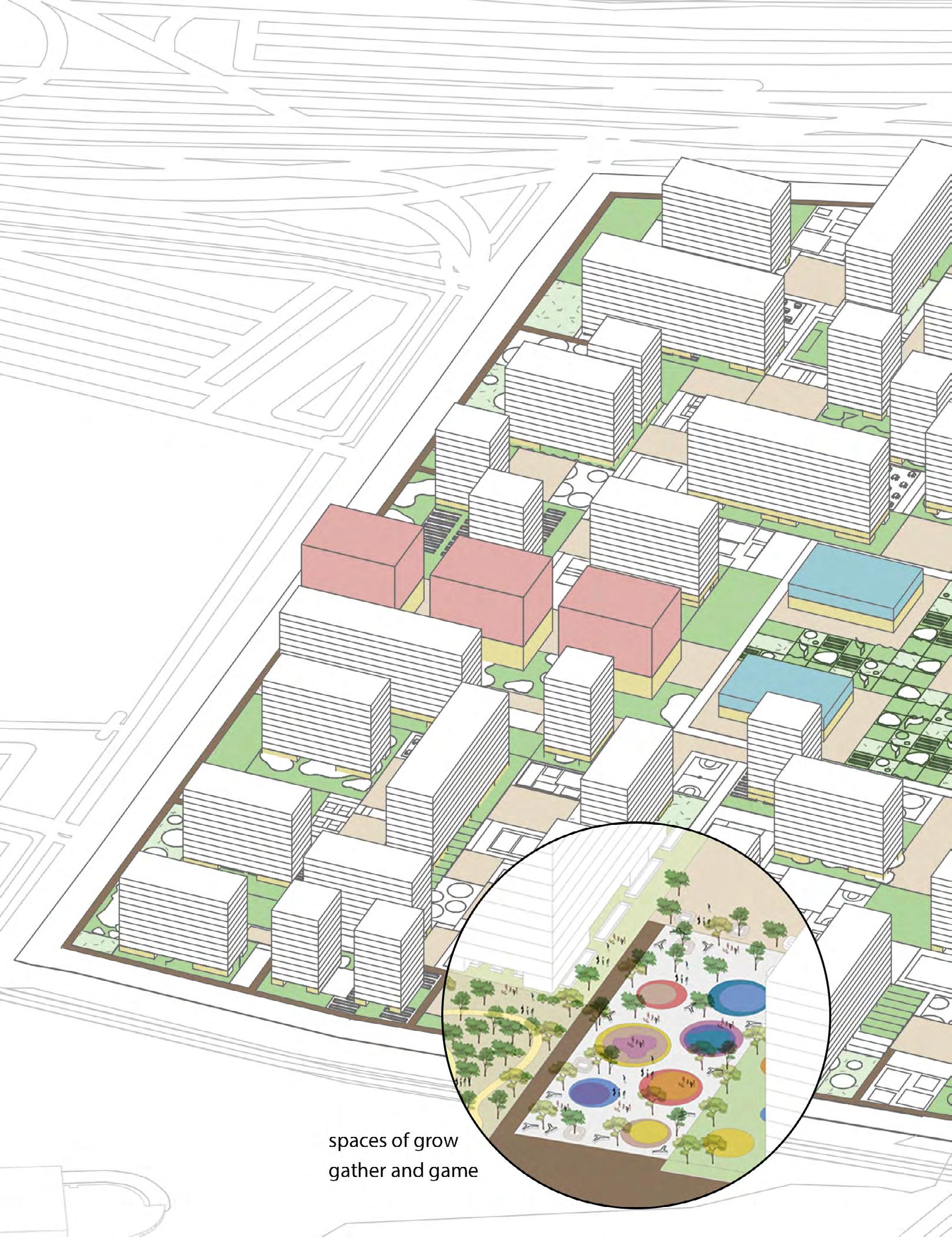
The third semester project at Taubman College of Architecture and Planning guided by Professor Sharon Haar focused on ‘Urbanisms of Sociality’ & the importance of social infrastructure in communities today. The project called The Handmade Commons is located in the border of Englewood and West Englewood in South Side Chicago. Facing one of the worst disinvestment periods Englewood has had to endure from the government, The Handmade Commons focuses on creating platforms and spaces for the community to take empowerment into their own hands.


Englewood faces high levels of crime, food insecurity, vacancy and disinvestment from the government for which the mass school closures is an example. The community, through all of this, still remains strong due to their activist spirits and help from other local NGO groups. Common goals that the community strives to achieve are economic development, workforce development, environmental development, community stewardship and anti displacement.
The mapping process was the start of documenting potential; it was clear that disinvestment and the lack of infrastructure social and physical was not confined to englewood but its neighboring communities as well.


focuses on physical infrastructure i.e adaptive re-use of dilapidated structures and the construction of new commercial and residental buildings

focuses on the streetscaping of neighborhood roads and increasing the overall green coverage

focuses on converting vacant lands under govt. ownership to POP! spaces or community driven hubs of activity
focus site boundary


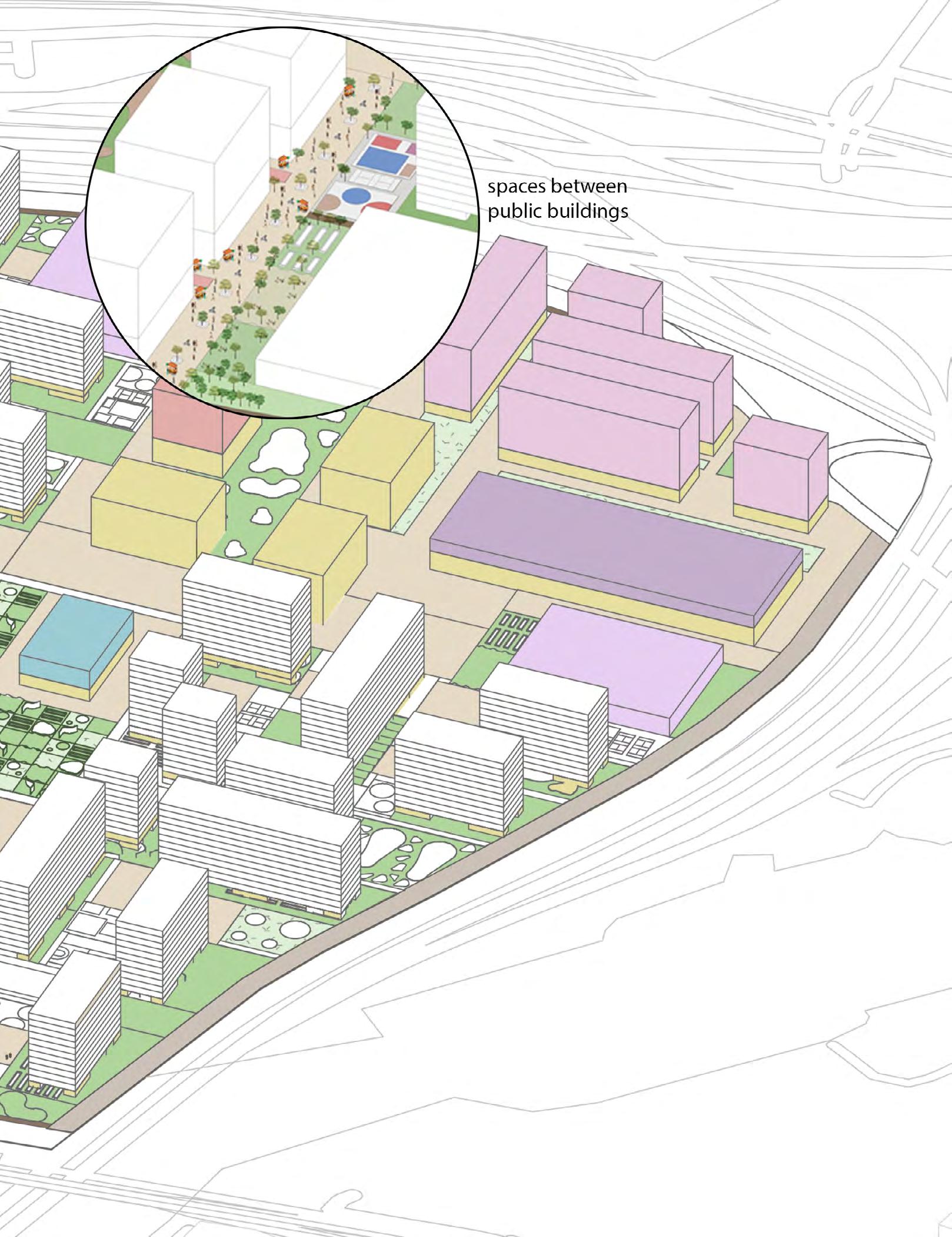
School of Community Empowerment


phase one is the activation of the two closed schools by repurposing them into schools of community empowerment and food sciences

phase three is the densification of the neighborhoods by the creation of new homes on vacant lands or by renovating dilapidated structures

phase two is the creation of the commercial corridor acting as the binding space between the two neighborhoods creating economic oppurtunities
focus site boundary commercial corridor


top: the commercial hub in phase 02; a space for local business to thrive re-using existing and available shipping containers on site to strengthen the commercial corridor
bottom: the POP! IN space in phase 03 where the community comes to gather to hold events according to their needs; a space to play, exhibit, protest and gather
the

“ “
the englewood pavilion is a great place to spend time because of the different activities that happen here! I almost always run into my neighbors and we end up spending time discussing different events to plan for our communities

bottom: the englewood pavilion that was previously

“ “ “ “

Master of Urban Design: Semester 01
New York City
The first semester project at Taubman College of Architecture and Planning with the guidance of Professor McLain Clutter focused on urban design through the lens of technology and how urban spaces can be designed using data ethically. The site chosen is Willet’s Point in New York, an area that faces continuous gentrification and neglect from the government
Individual Work

The project focuses on landscape urbanism as a way of redefining the use of streets and the normative way of defining the urban fabric through buildings, streets and sidewalks. This project is a provocation to the current master plan that is designed for Willet’s Point since the same requirements are met using different design strategies that promote better engagement of communities and people.
The different land uses that dominate the site at Willet’s Point are the ecological layer, the housing tower layer and the cultural spaces that support communities.


site zoning
in response to context and project requirements


The design strategy focuses on the connections between the residential towers and the different kinds of public spaces mentioned in the catalog. They are primarily connected through the ground floor of the residential towers that lie vacant and open to facilitate connections between the green spaces.


pop up spaces that emerge as a result of the weaving of cultural, economical and housing layers


The project comes under the United Nations Development Program and the Government of Kerala for the HRML project that targets tourist destinations of three districts in the state of Kerala which have fragile eco systems and potential for development of the local economy. The site is a 20km road stretch running along the length of the Athirappilly Panchayat of the Thrissur district and is of the major connecting routes between Kerala and Tamil Nadu and is often also a tourist destination because of the famous Athirappilly waterfalls.
Team: Ganga Dileep, Sanjana Jismon, Sunny Gupta, Anu Issac, Alen Thomas

Athirappilly, a first grade grama panchayat in the district of Thrissur is famous for its ‘Niagara Falls’ like waterfall and is home to a great deal of diverse flora and fauna. The road leading to Athirappilly waterfalls is a scenic and serene drive that connects you with the mountains on one side and the Chalakkudi River on the other.
The road is presently an access to Athirappilly Waterfalls and is a connecting road to Tamil Nadu. The project focuses on the 20km stretch between and the Athirappilly Waterfalls by revamping the corridor that will ultimately benefit the local community, tourists and the local flora and fauna as well.
A model eco corridor encourages effective local participation and also instill a scene of respect and responsibility among visitors. In Athirappilly, the corridor is essentially one that acts as a connector to the urban and forest eco system.

“We are from the schedule tribe/ schedule caste and our income comes from daily wage jobs. We have no job security and depend on government organizations for work. We have no land or house ownership.”


are of the general category with ownership, cultivation and run small businesses in the panchayat income. Our businesses depends the tourism that is connected to athirappilly.”


“We are tourists to athirappilly and have come to see the waterfalls. We do not take part in any responsible tourism activities as none are provided here. Our education of this land is less.”


An intriguing and obvious character of the site are the disconnections that exist in the various levels. The basic disconnection i.e. physical is a result of the geography of the site. The grain of the fabric is distributed in such a way that after an area of activity/engagement there will be sparsely occupied areas.
This lack of continuum has a considerable say in the behavioral pattern of the crowd. This physical factor serves as a base for other levels of disconnections; between the tourist and community and also within the communities, thus giving rise to several instances of irresponsibility.
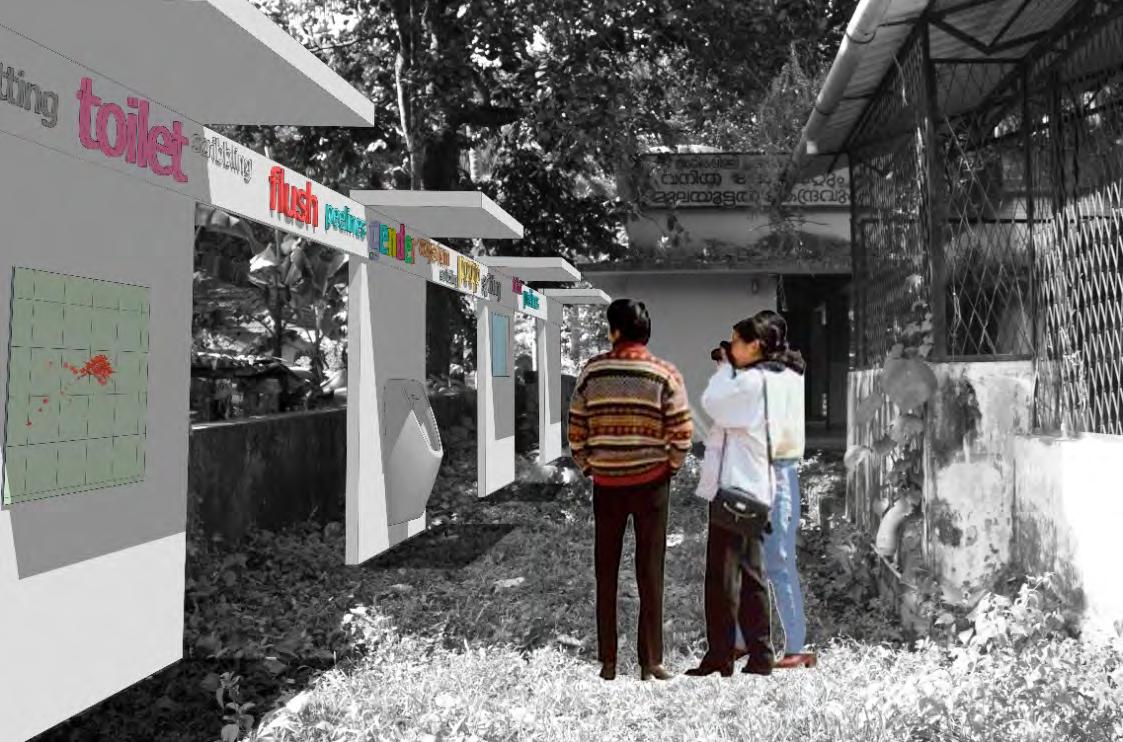
A major objective is to introduce node based interventions based on identified parameters of sustainability such as waste management, energy usage and wastage, water management, tropical landscape, sanitation methods and mobility and transportation as the key connecting point of nurturing responsibility of community and tourists.Each node is envisioned to be a holistic composition of flora, fauna and reflecting parameters of sustainability and responsibility.

The Arrormuzhy Community Hall or the Green Literacy Node has potential as a node because of the open public space in and around the community hall. It also has an existing toilet in the back in good condition. The waste segregation group MRF has a plant behind the community hall that is used as an area to collect and segregate waste from the community.

A wall that is predominantly green but also serves the purpose of a boundary wall.


The water temple, also signifying the birth of water is the revamping of the existing well on the site.

Master of Urban Design: Semester 02
South East Michigan
The second semester project at Taubman College of Architecture and Planning with the guidance of Professor Gabriel Cuéllar and Salam Rida focused on urban design through the lens of justice and how property and land ownership plays a major role in supporting equitable spaces for people
Team: Diana Anda, Sanjana Jismon

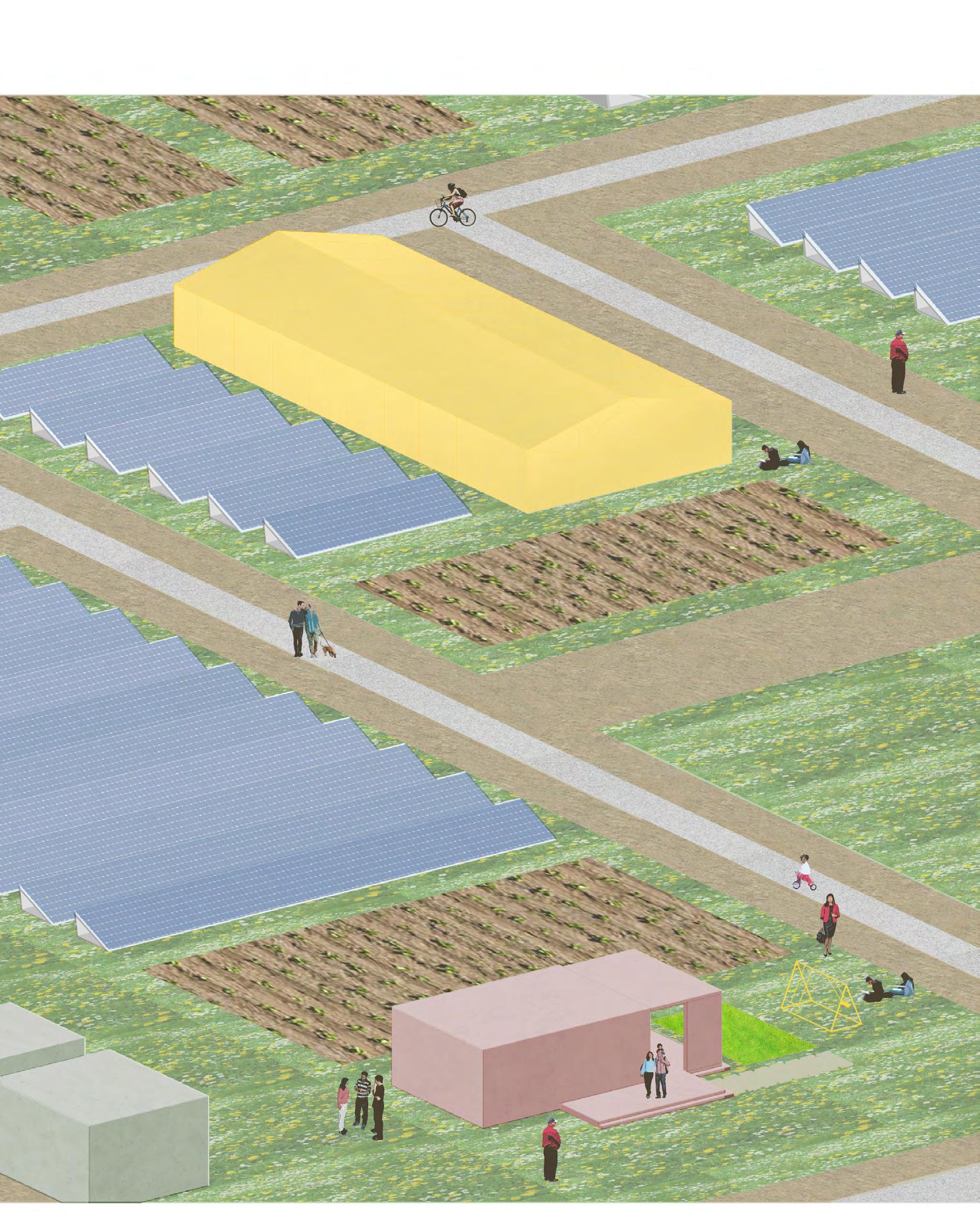
The project focuses on different communities in Monroe County. This is a speculative project that imagines a future where the existing centralized, monofunctional, and outsourced system becomes challenged. This design process aims to involve all stakeholders and challenge the different notions of power and agency. Through decentralization, localization, and integration this design system ultimately negotiates towards more equitable communities, rooted in justice.

click for video of the project

pin up of research work done on monroe county in the form of pamphlets, broadsheets and field guides


limit spatial application of energy farming and control of energy distribution and generation
reduce the presence of outsourced and transition to local oppurtunities
Local owners are capped at a maximum of 50% land used for energy farming.
Energy farms cannot be adjacent with each other.
Energy sourcing becomes distributed through different local source.

No private outsources investment. Partnership! Between government and land owners. energy equipment, if 30% of the land

outsourced investment oppurtunities
create negotiations between the local communities, government and organizations
owners. The government can provide land is used for community purposes

Incentivize the integration of solar farms with agriculture and other functions
Create programs for local businesses to help transition from at-home businesses to pop-ups.


a space where the three concepts have been deployed showing the decentralized solar farms, agricultural areas and other required infrastructure for communities
Team: María Arquero de Alarcón, Sanjana Jismon
Wahnabezee and the future [hi]stories of place is a project supporting the co-creation and circulation of community narratives along the waters of the Detroit River. Wahnabezee, also known as Belle Isle Park, is an enchanted island, a real site and an imagined place, and a fluid commons of sorts. For centuries, the island has served as refuge and sanctuary, a shared natural resource for humans and non-human species alike.
Website Building


Through the collection and circulation of real and imagined narratives, memories, images, maps and other traces, we aim to steward the future of the public park as a pluralistic cultural commons, a place of belonging and wonder.


distributing postcards and asking the visitors to share their stories of belle isle
using the game board as a fun way to learn about belle isle’s history and engage with the community


Team: Ganga Dileep, Sunny Gupta, Meenumol Peter, Sanjana Jismon
The potentials of the highest population group in the community, i.e children below 18 years of age, are being identified. The potential for the young generation to be the prospective change makers in the community is identified. The program envisions them to be channelized to become the change makers of the community
Activities conducted for the workshop

Starting

Adakalakootam- a community involved activity where everyone gets together to make food for dinner. This helps in bonding with them easier.

Discussions
It is a commonly seen approach to adopt the so called developed societal strategies to respond to the situations in the indigenous communities.
Most of these interventions or schemes for the welfare of the tribal people have a myopic nature due to the fact that they are superficially framed.
Hence there is a tendency for the proposals made in this manner to not necessarily resonate well with the community structure.


Encouaraging them to draw their dreams and aspirations as an activity thereby understanding their lifestyle

Converting their gathering spaces into an active area which the children will continue using over time.