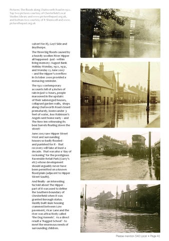
Pictures: The floods along Chatsworth Road in 1922. Top two pictures courtesy of Chesterfield Local Studies Library and www.picturethepast.org.uk, and bottom two courtesy of R Shemwell and www. picturethepast.org.uk
culvert for it), Goyt Side and Boythorpe. The three big floods caused by a heavily swollen River Hipper all happened - just - within living memory: August Bank Holiday Monday, 1922, 1932, and Monday 25 June 2007 – and the Hipper’s overflow in October 2000 provided a menacing reminder. The 1922 contemporary accounts tell of 4 inches of rain in just 12 hours, people marooned in the upstairs of their submerged houses, collapsed garden walls, shops along Chatsworth Road closed prematurely, looms under 3 feet of water, 800 Robinson’s Angels sent home early – and The New Inn witnessing its beer barrels floating down the street! June 2007 saw Hipper Street West and surrounding houses so badly flooded and punished for it - that recovery will take at least a decade. That was also a ‘day of reckoning’ for the prestigious Ravenside Retail Park (Curry’s etc) whose development should arguably never have been permitted on a known flood plain (adjacent to Hipper Street South). And finally - an interesting factoid about The Hipper part of it was used to define the Southern boundary of Chesterfield when it was granted Borough status. Hastily built slum housing crammed between Low pavement, Vicar Lane and the river was attractively called ‘the Dog Kennels’. As a direct result a ‘Ragged School’ - to meet the enormous needs of surrounding children. Please mention S40 Local • Page 41