LA 504, Speculative Design Studio
Spring 2024
Spring 2026
About the Studio
LA 504 is an advanced design studio that introduces the student to speculative design. The students learn about the different degrees of speculation, from projects that ask “what problems are we solving for today?” to “what problems are we solving for in 30, 60, even 90 years?”
About the project
In Spring 2024, I asked the students to implode the culturally accepted separation between human and non-human animal, and explode (or perhaps even reverse) its implicit hierarchy. We set, through design, to transcend the dualistic human/animal framework and open our cities, our landscapes, and our minds to a more respectful and caring interdependence on other creatures.
We began by reading the Introduction to Donna Haraway’s Staying with the Trouble: Making Kin in the Chthulucene, and discussed her concept of “Multispecies Response-Ability.” The students reflected on the purpose and possibilities of using the speculative approach to such a project, and how it allowed them to imagine the life of another species in resplendent fullness.
In the Research and Problem Statement phase, the students’ task was to research a particular “client” animal, or type of animal, the environment in which it flourishes, and to clarify the ecological relationships on which their client relies. They then chose a place where the animal occurs, studied the affordances of that place, and integrated this information with their knowledge of the client’s needs (energy, shelter, procreation, movement, interaction, environment, etc.) to identify gaps or problems facing the client. Students represented this information through mapping, infographics, drawings, and narrative.
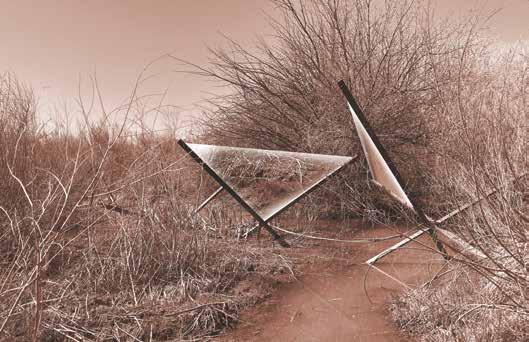
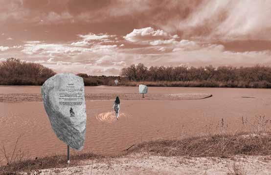
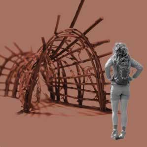
In the design phase, students used the research and problem statement as a springboard to conceptualize a landscape intervention, artifact, structure, system, or process that would solve a problem or improve their client’s life. Students designed shelters (American Pika), migration corridors (tarantula) and systems to restore sustainable habitat (nicely done in a whimsical “Bear Welcome Center.”) They celebrated feared and misunderstood species (bear, tarantula, snake). They paid special attention to mutualistic relationships between the animal and its surrounding biome.
The more successful students were those who chose clients with whom they had personal connections, but all of them were able to develop strong projects that deepened their understanding of complex adaptive systems and how we participate in them.
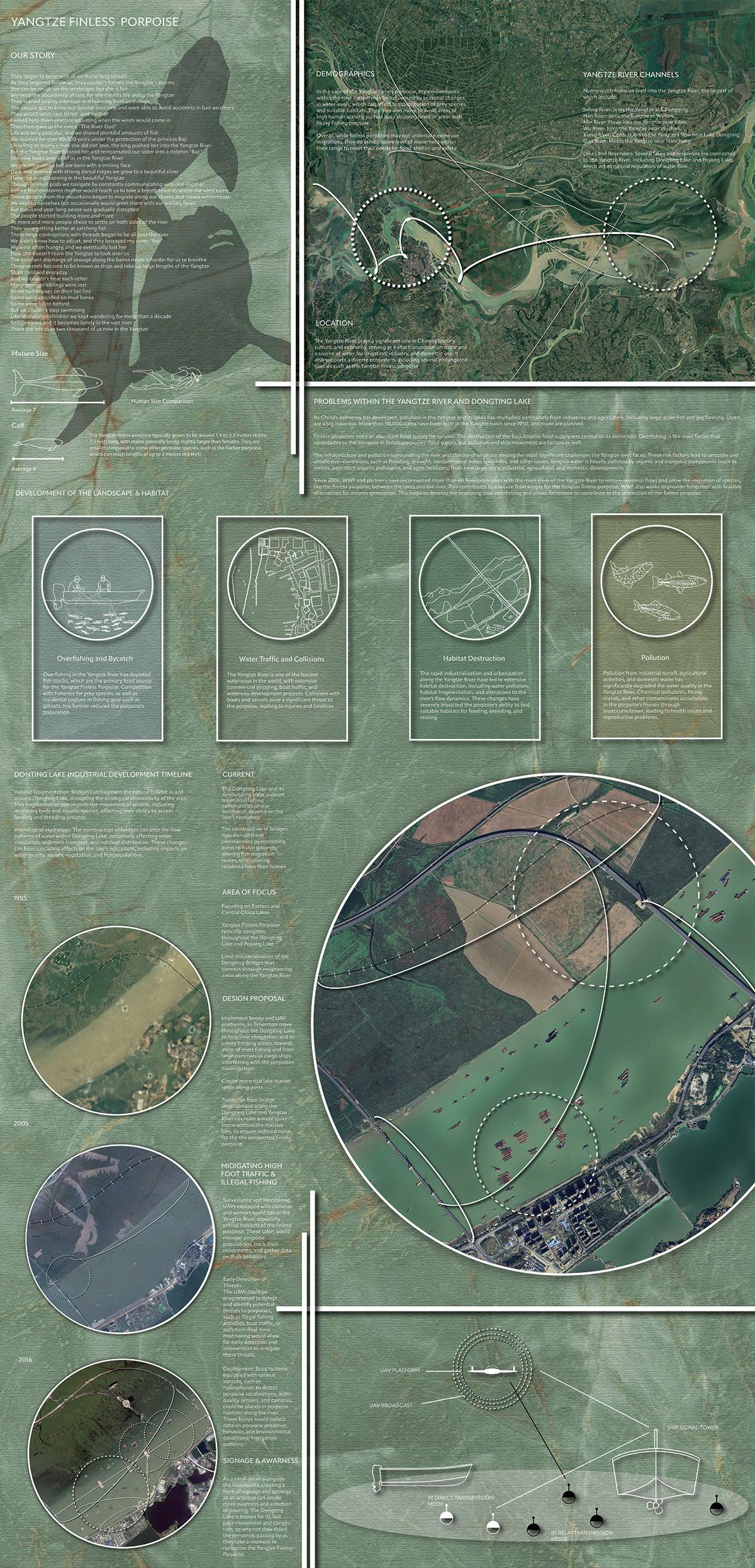
Research + Problem Statement: Yangtze River Porpoise
Student: Miles Harris
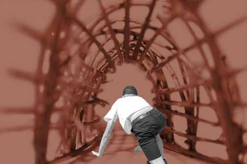
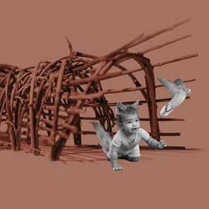
APROACHING
CRAWLTHROUGHTHETHICKET
EMERGENCEFROMTHETHICKET
LA 401/501, Design Fundamentals Studio
Fall Semester 2022
Fall Semester 2023
Fall Semester 2024
About the Studio
This is the first studio of a 6-studio sequence in the graduate landscape architecture program, and the first studio in the BAEPD undergraduate concentration track. It covers the fundamentals of landscape architectural design and lays the groundwork for subsequent studios. During this course, the students are led on an experiential journey to understand space and the built environment. They explore the ecological factors that inform landscape design as well as social and cultural factors. They learn to practice what Anna Tsing calls the “arts of noticing:” observation and pattern awareness as well as the phenomenology of being in space, which they practice by sketching, note-taking, and site analysis. The students also learn representation and communication techniques and how to incorporate constructive feedback into their process. Finally, I introduce the students to the many possibilities of landscape architecture and consider what it means to be a designer in this time and place.
About the projects:
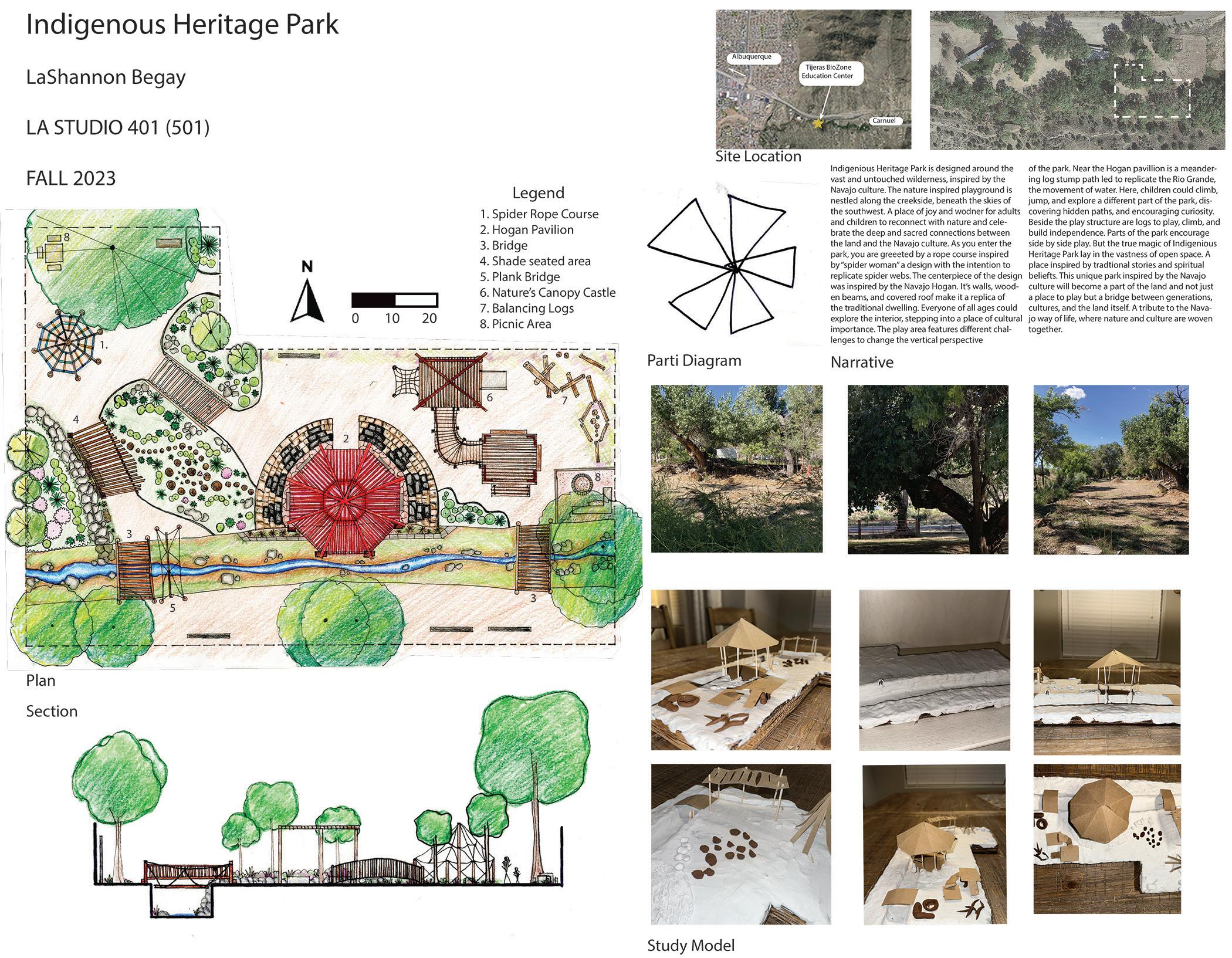
1. Nature Playground: The students studied precedents for, modeled, and designed a nature playground along Tijeras Creek in the Tijeras BioZone Education Center.
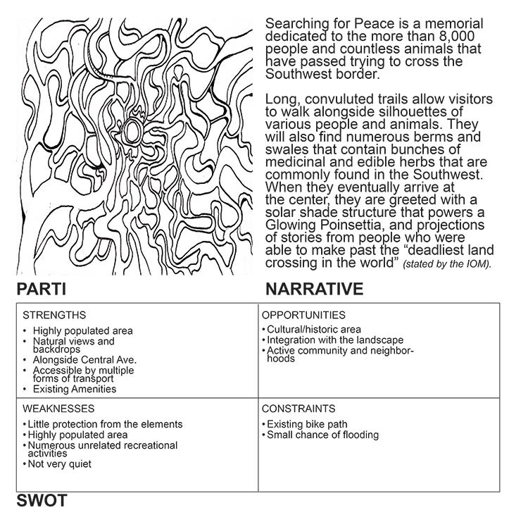
2. Anti-Memorial: For this project, the students prepared by reading SueAnne Ware’s article “Anti-memorials and the Art of Forgetting,” and then designed a memorial around a particular topic they cared about. The students considered how to design a space that recognized a difficult social problem while also offering hope. Through this process, they were encouraged to consider what is worth remembering, and how to design for recognizing a shared social history through specific events. Who decides who or what should be memorialized? What narrative will be shared? Where will it be located, and who will have access to it?
3. Exiting Asphalt: In the second example, the students were asked to create an eco-revelatory design that would bring life back to a .75-acre urban parking lot. We discussed the meaning of eco-revelatory design and looked at precedents, and then the students selected a natural phenomenon they wanted to explore and use as the basis of their designs.
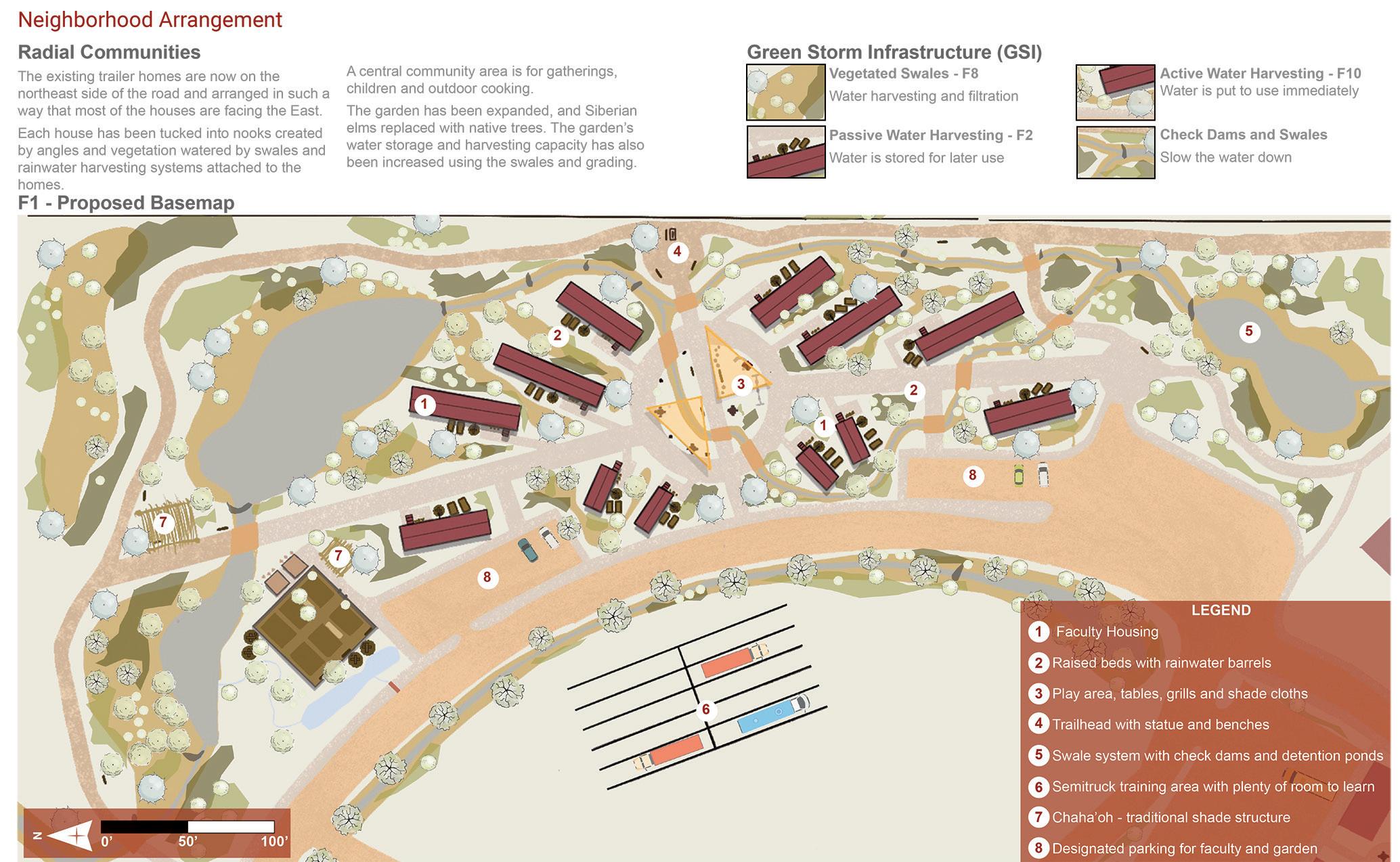
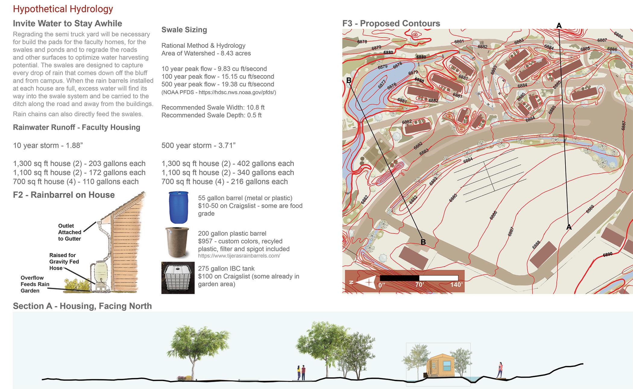
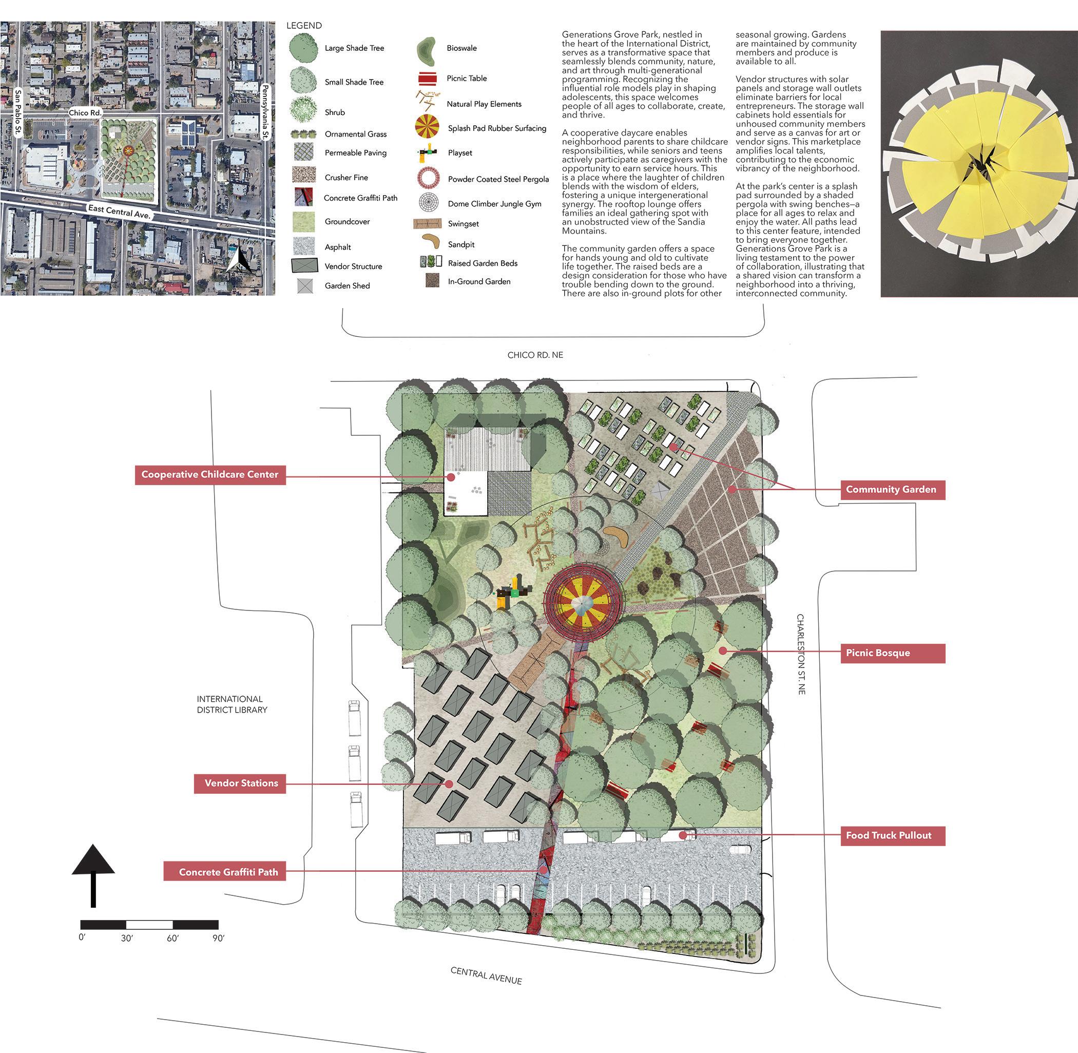
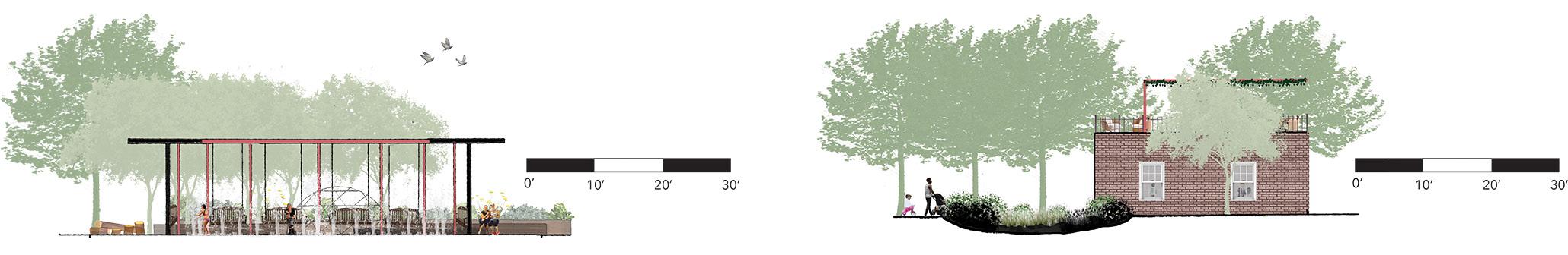
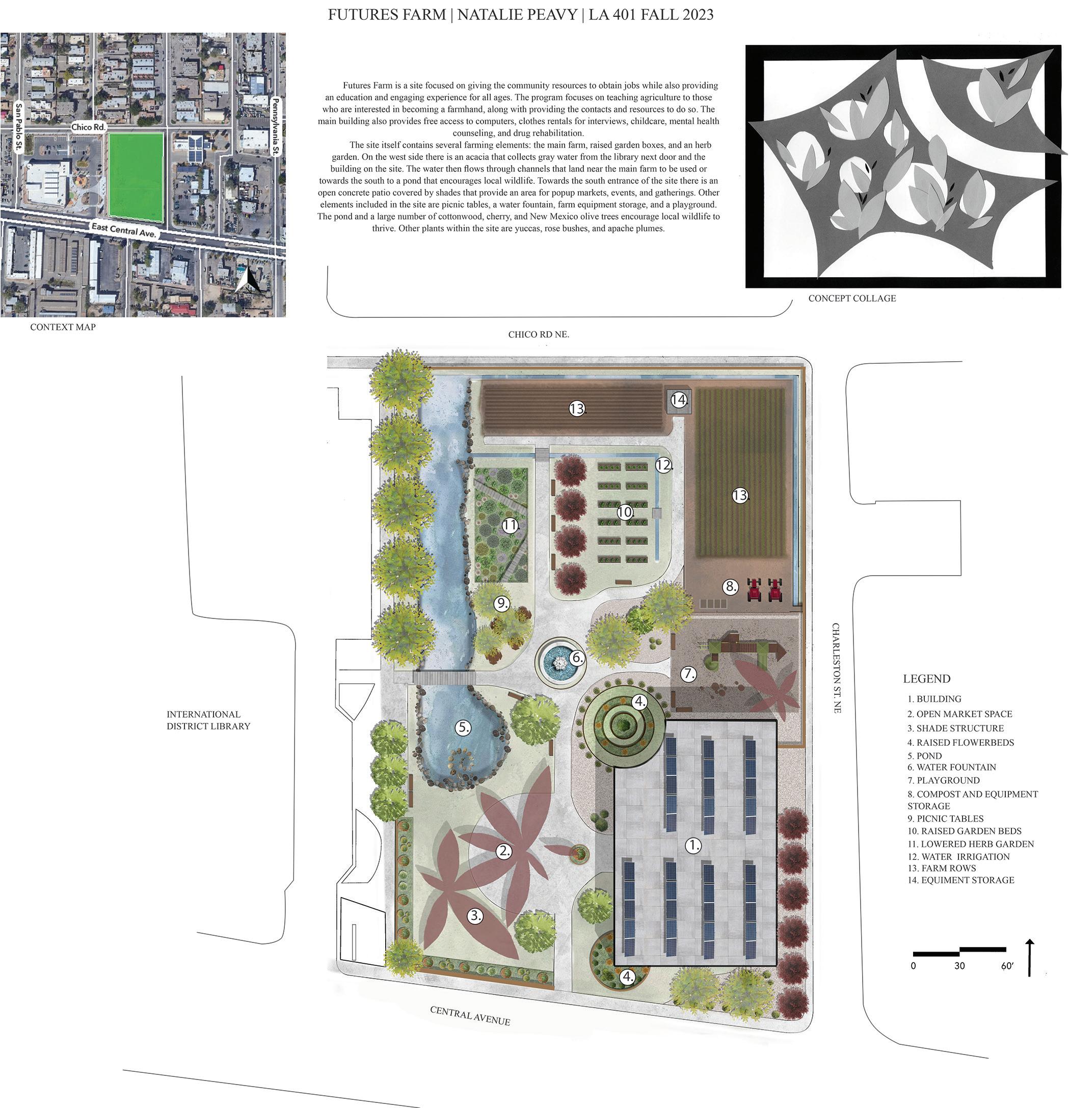
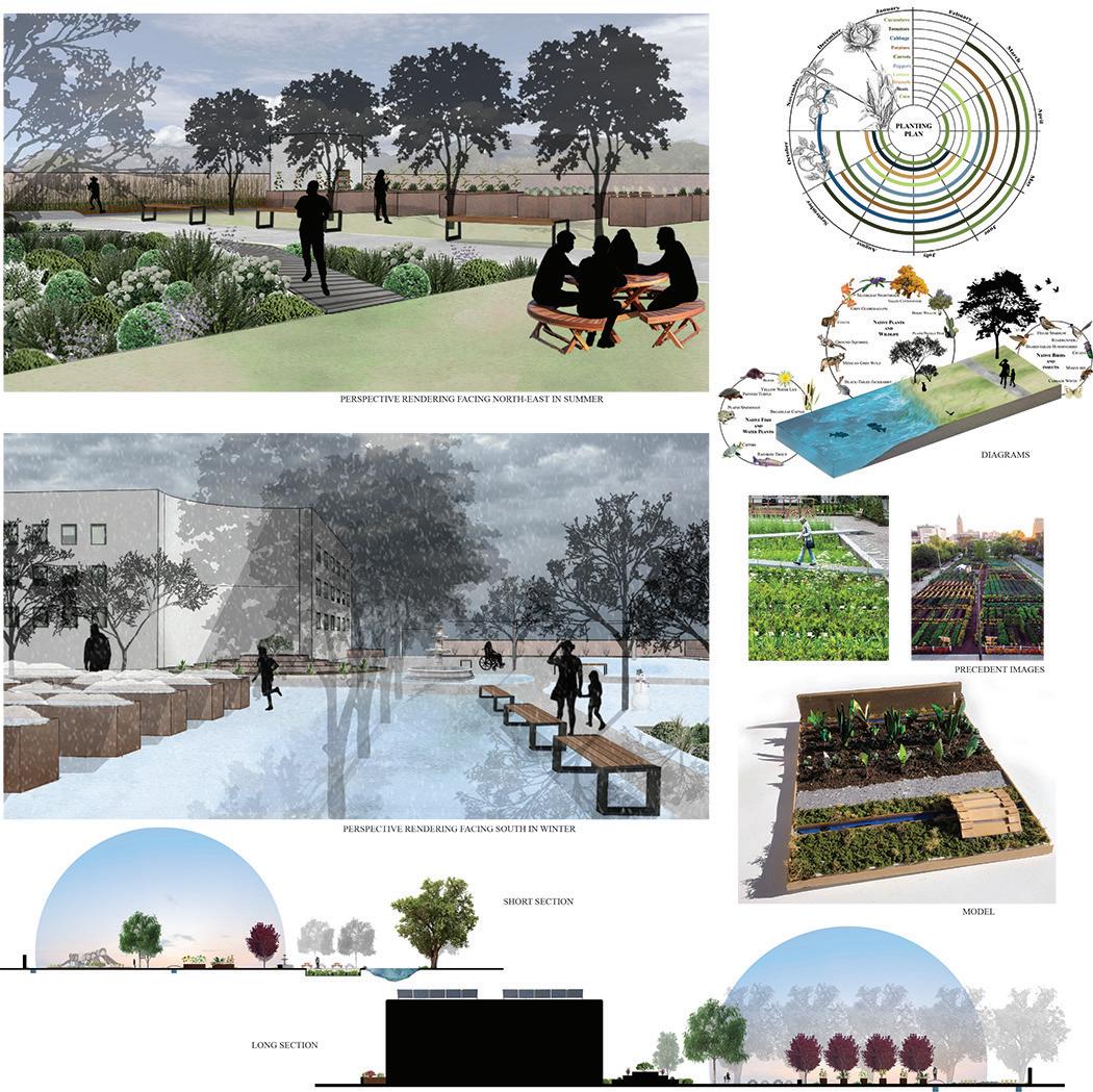
4. Neighborhood Commons: This project introduced students to the concepts of place-keeping and urban commoning in an underserved neighborhood of Albuquerque. To begin, we read an excerpt of David Bollier’s book Think Like A Commoner and discussed the definition of a “commons” as a type of landscape structure in which community members contribute to the management of the space (a type of place-keeping). “Urban commons” refers to resources and services that are essential for the exercise of fundamental rights in cities (e.g., housing, health, water, energy, transportation, education, etc.) and that are governed collectively in a way that transcends a clear-cut public-private distinction. We also talked the Blackfoot philosophy that inspired Maslow’s hierarchy of needs, and its communitarian focus. The requirements of the brief were that the design offer a unique social and cultural experience, regenerate the soil, water and air, and meet one or more basic human needs: food, play, creativity, political empowerment, or something else they saw as essential. Students researched neighborhood demographics, assessed service gaps, developed their own programs for the two-acre site, which included an urban teaching farm, a co-operative daycare, a toolsharing workshop, a cell-phone repair center, and an employment-resource center.
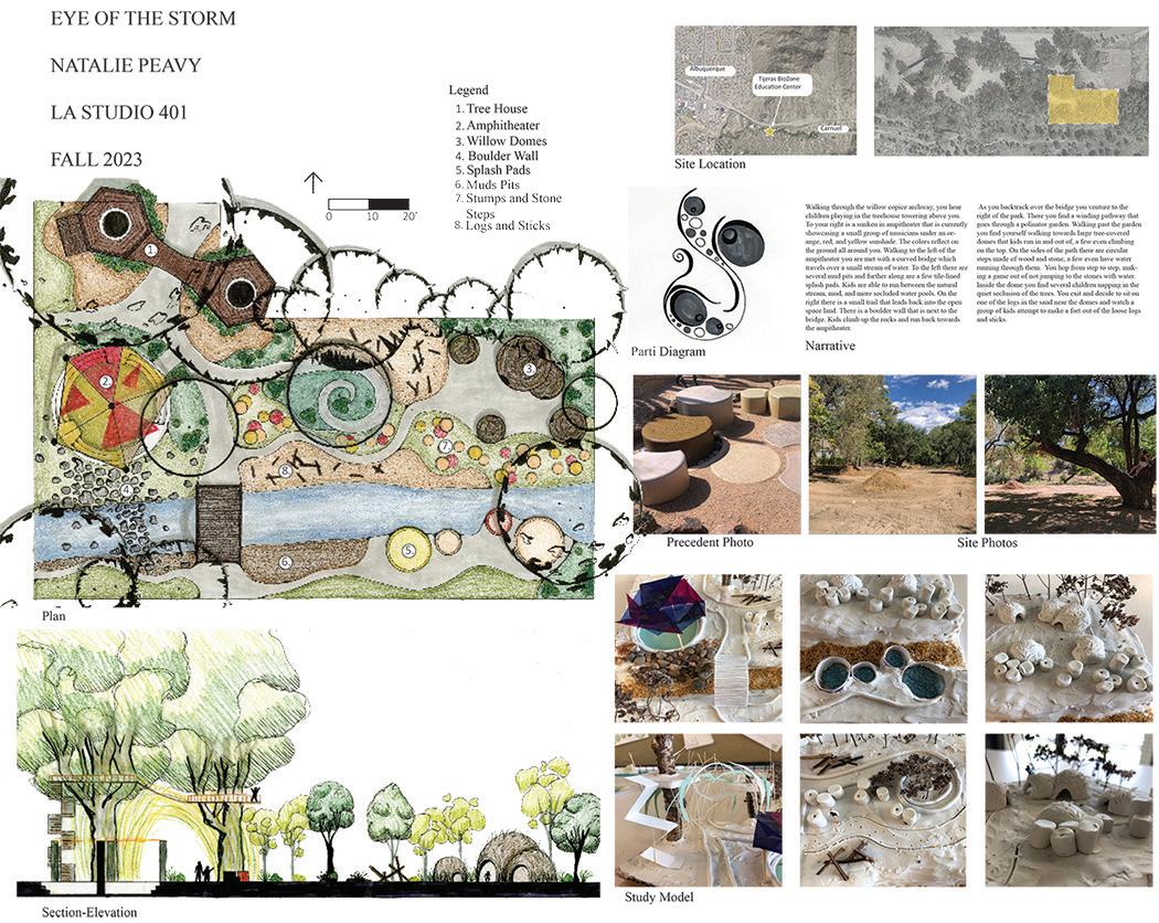
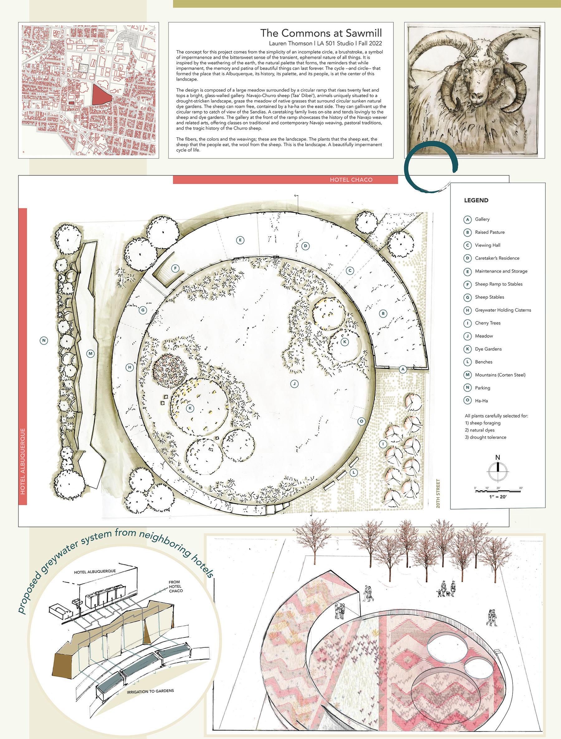
Student: Natalie Peavy
Student: LaShannon Begay
Project 3: Exiting Asphalt
Student: Lauren Thomson
Luciano Chavarria | LA 401
Student: Holly Hearn
Student: Nataie Peavy
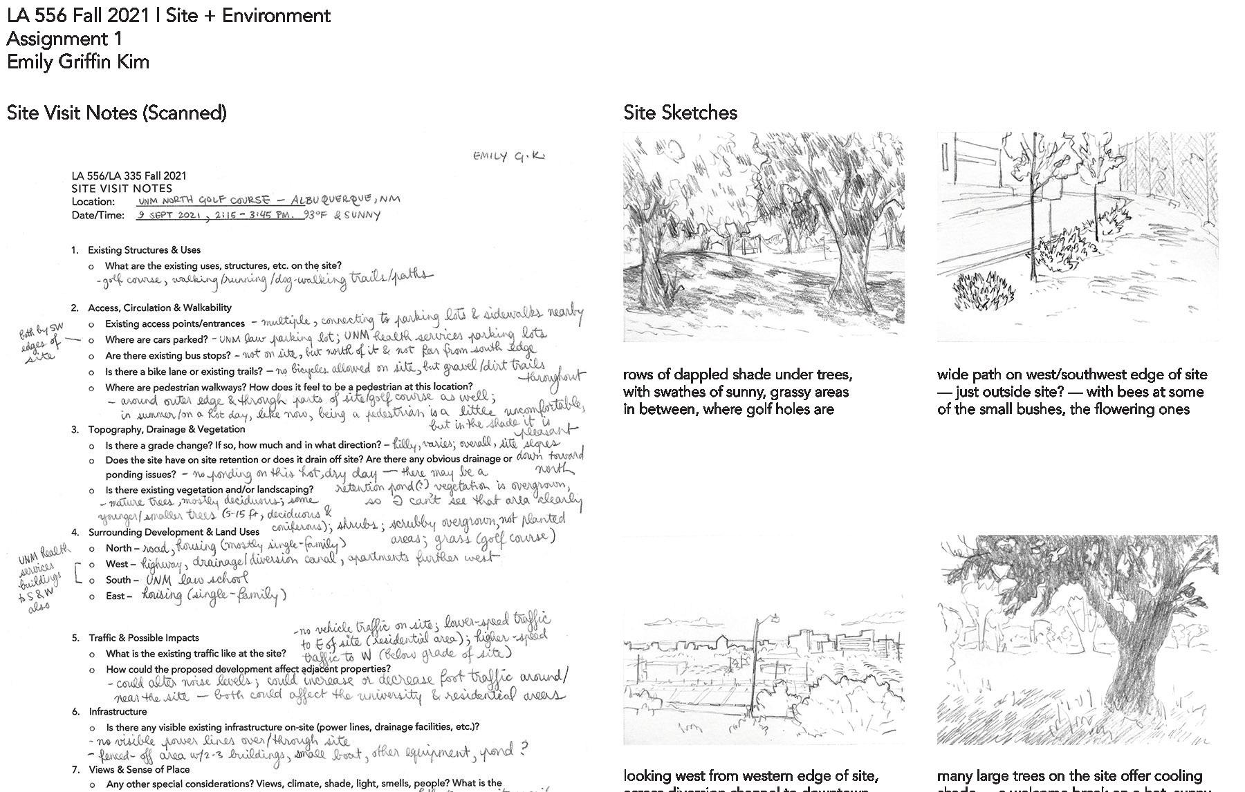
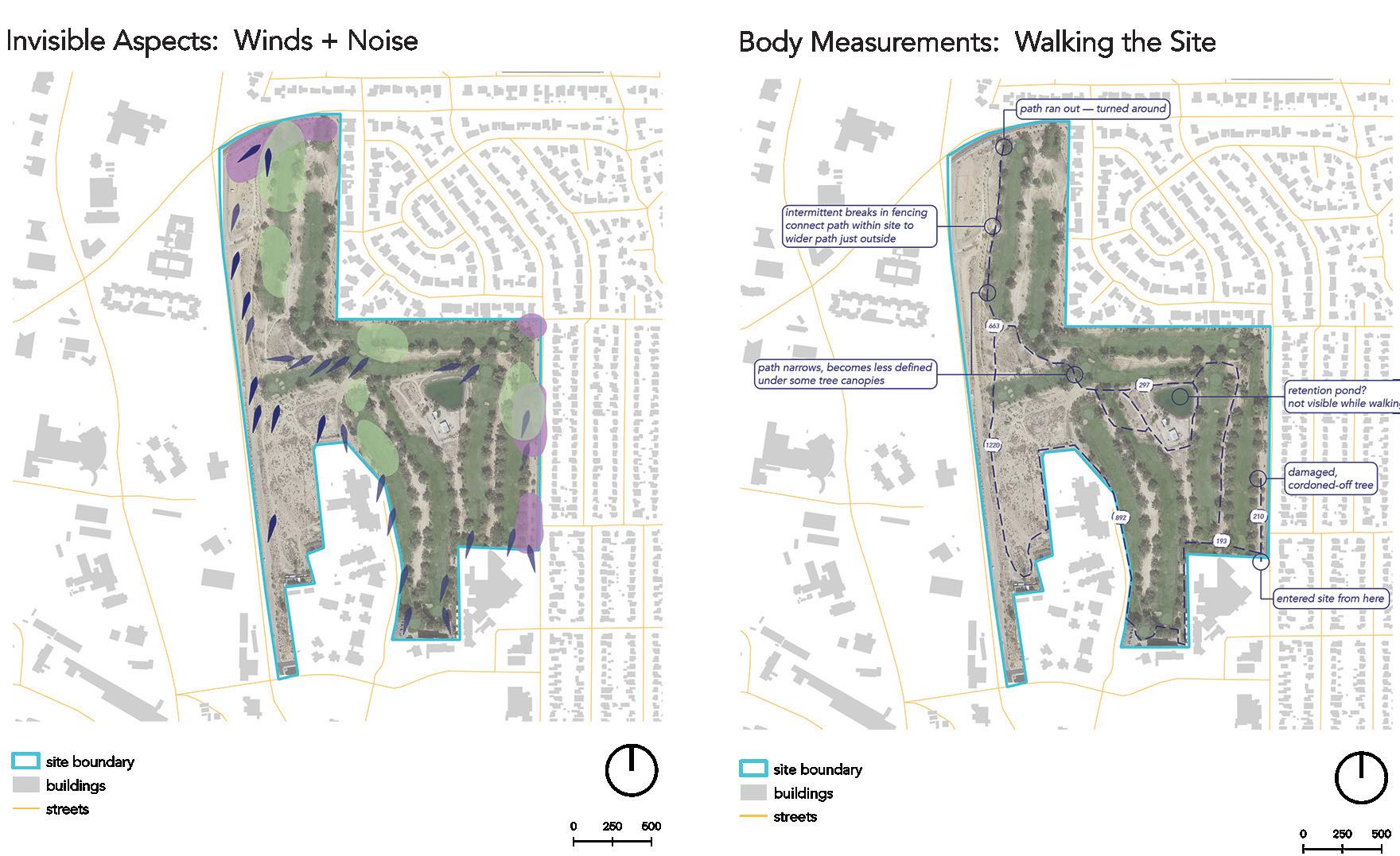
1: Site Encounters + Mapping
Project
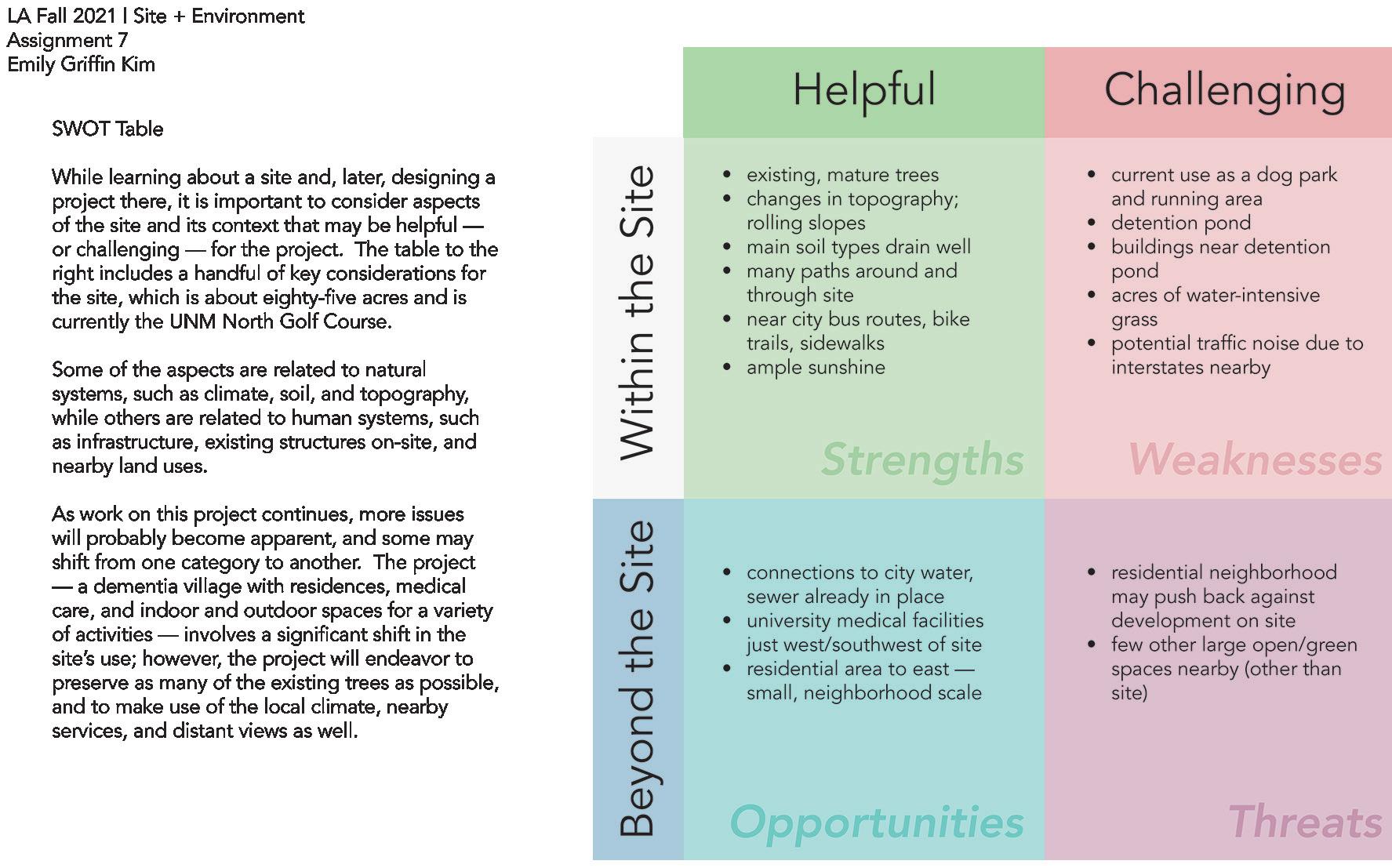
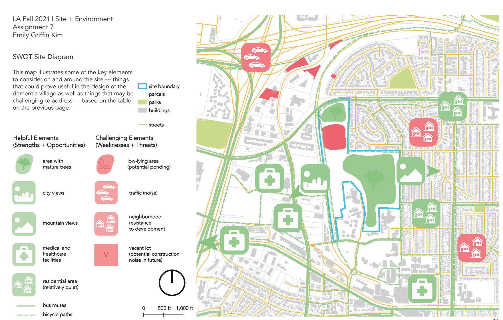
3: SIte Plan for Dementia Village
UNIVERSAL DESIGN & DEMENTIA CARE
GOALS
TO REDUCE ANXIETY, AGITATION, CONFUSION & DEPRESSION THROUGH DESIGN
TO MAINTAIN PHYSICAL BARRIERS TO PROTECT BOTH THE INHABITANT AND THE PUBLIC
TO ENCOURAGE BRAIN ACTIVITY & SENSORY STIMULATION
FEATURES
ENCOURAGING WANDERING SPACES FOR REST
EASE OF ACCESS TO NECESSITIES
ENGAGMENT INSTALLATIONS
THEMES/COLORS/PATTERNS TO INCREASE MEMORY AND BRAIN ACTIVITY
NATURAL LIGHTING AND EASY ACCESS TO BOTH PRIVATE AND PUBLIC OUTDOOR SPACES
Students: Brianna Horvath, Jade Altheide, Sören Miller
Project 1: Site Encounters + Mapping
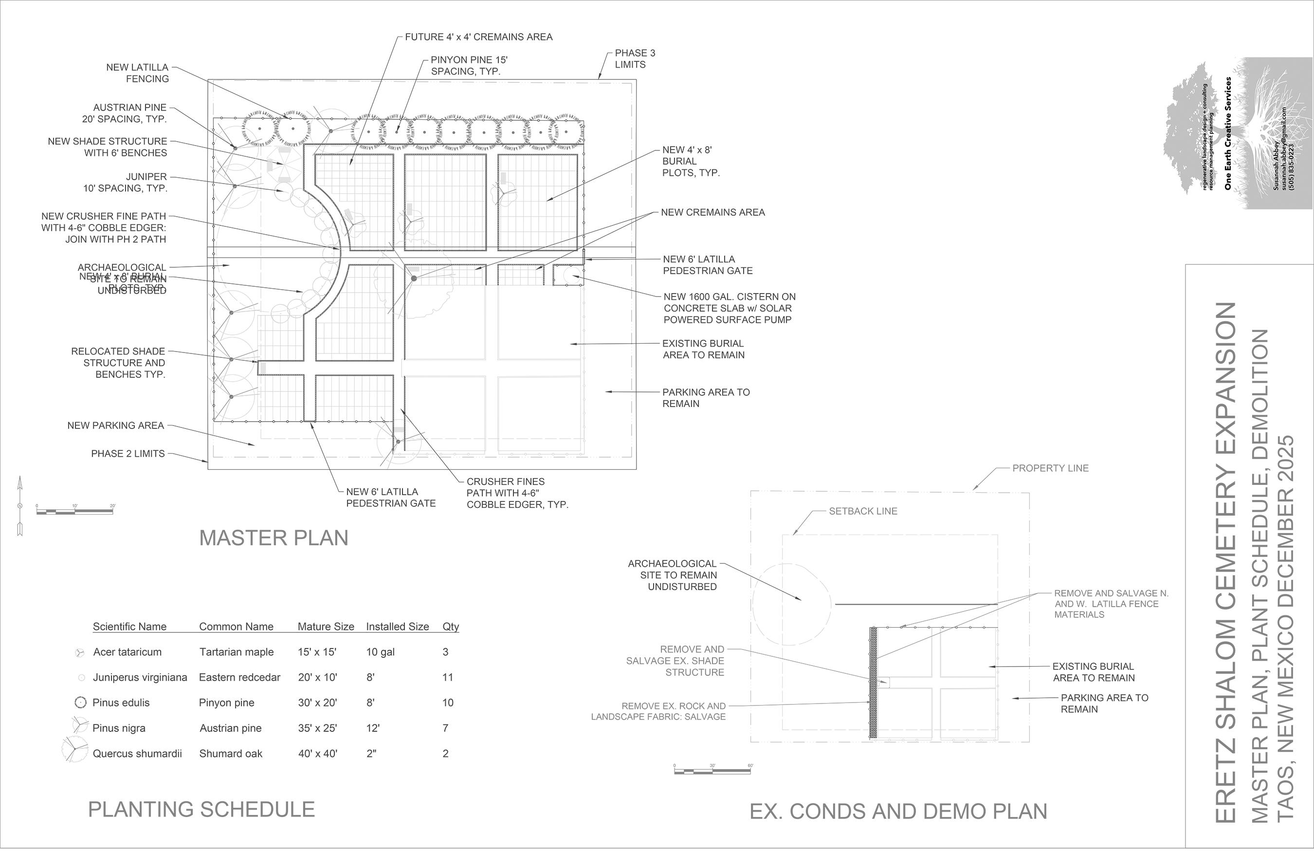
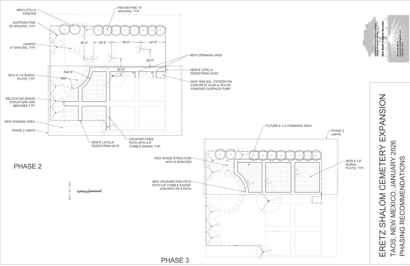
Eretz Shalom Cemetery Expansion, In Progress
Client: Taos Jewish Center
The design intent was to create a sustainable, beautiful place of sacredness and ceremony on a mesa southwest of the Town of Taos. The client wanted a ten-year plan for a phased buildout on the one-acre parcel. The two major constraints were a lack of available water for maintaining plants, and an existing archaeological site on the west side. The design proposes a solar-powered pump with a 1600-gallon cistern for irrigating regionally-appropriate trees and native meadow species. An arc of junipers describes the archaeological site in a form reminiscent of the dome of a synagogue facing east.
Bottom: Phasing Plan
Right: Site Plan
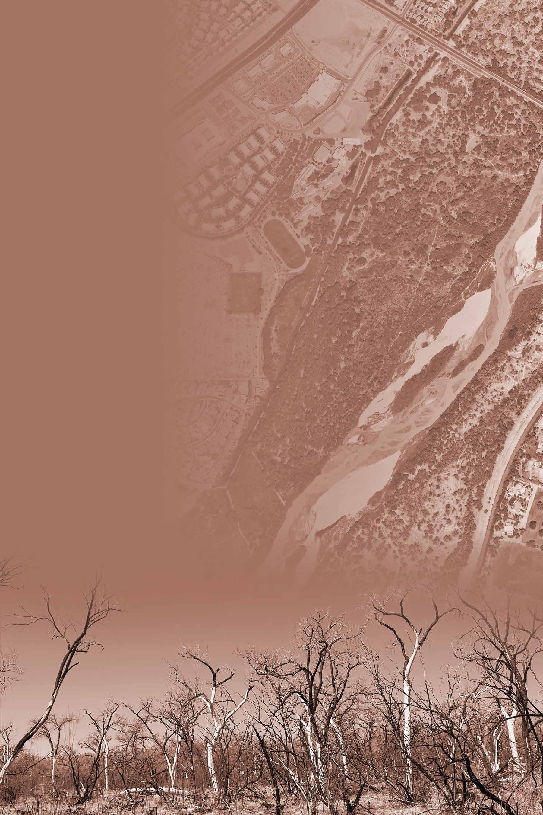
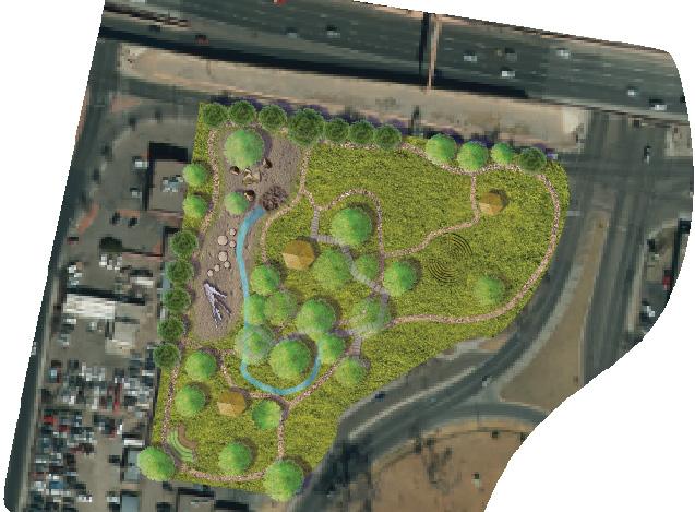
Tijeras Corridor Master Plan, 2022
Client: City of Albuqeurque Open Space Division
I was contracted to research and write the text of a cultural corridor plan, including historical, cultural and ecological features of Tijeras Canyon. The planning team then adapted the text into a public-facing ArcGIS storymap. An excerpt from the original text is included here.
Regional Context
Tijeras Creek flows from the Village of Tijeras and unincorporated Bernalillo County, about seven miles east of the Albuquerque city limits, through a steep-walled canyon made by the foothills of the Sandia mountains to the north, and the Manzano Mountains to the south. The Tijeras Creek Cultural Corridor is a 12-mile, irregular swath of land that follows the creek, from the Ojito de San Antonio Open Space in Cedar Crest about 12 miles west southwest to the boundary of the Kirtland Air Force Base. As a conduit, Tijeras Canyon permits the flow of water, animals, and people. It has been used for centuries as a passageway between the great plains to the east and Rio Grande valley to the west. Indigenous peoples used it for seasonal migrations and trade as well as more permanent settlements. It was the route for Apaches and Comanches raiding the Spanish Colonial villages along the Rio Grande, occasioning the Carnué Land Grant which gave generations of Hispanic and Genízaro settlers land of their own. It also served as the route for the Long Walk, when Navajos were forced from their ancestral home to Bosque Redondo at Fort Stanton. It was a place of respite and healing for “health-seekers,” who came to the Tuberculosis sanatoria in the early 20th century and decided to make it their permanent home.
Several ecological communities meet here as well. The mountain pass connects three different plant and animal communities: the Southwestern tablelands, conifer woodland savanna, and the Albuquerque basin leading into the Arizona/ New Mexico Plateau. The creek itself contains riparian vegetation and provides forage and habitat to many migratory bird species.
The canyon now serves as a major cross-continental travelway which is still celebrated as a piece of classic Americana, Historic Route 66 (also known as New Mexico Highway 333). Interstate 40, built in the 1950s, facilitated the increase of high-speed cross-continental travel. Visitors driving from west to east can take the Historic Route 66, hear America the Beautiful on the “musical road,” stop at historic Molly’s bar and visit the Tijeras Pueblo ruins. Visitors traveling west toward Albuquerque pass
Gordon Heuther’s Aluminum Yucca, a 22-foot yucca made from salvaged hollow aluminum fuel tanks, a nod to the city’s importance as a military base. And as they leave the canyon, they will see the Rio Grande valley open up before them. In this way, the Tijeras Corridor is a place where people can cross paths, share economic and social experiences, and learn about the landscape and cultural history of the area.
Early Agricultural Settlements
The Tijeras Canyon was originally inhabited by Ancestral Puebloans in what is known as the Tijeras Pueblo, just south of the Village of Tijeras. For hundreds of years, smaller groups of hunter gatherers had lived in the region and used this site along Cedro Creek as a camp, building pit houses–temporary shelters–that they used as camps.
In the mid thirteenth century, an increase in rainfall allowed some agricultural activity, and the canyon was settled with small, year-round farming groups. An archaeological excavation at the Big Boulder Site near Dead Man’s curve (currently where the NM 333 crosses over the I-40) unearthed two pit houses from around 700 CE. Another excavation resulted in the survey of Dinosaur Rock, which contained six rooms and three jacal structures, and the Coconito Site. These surveys provide the earliest evidence of year-round living in the canyon.
In the late 13th and early 14th centuries, the creekside communities were abandoned as these small groups aggregated into larger communities. This is known as the coalition period, or Pueblo III. The first permanent structure at the Tijeras Pueblo appeared around 1313 CE, and in a short time, the Pueblo had around 250 residents. Other nearby settlements included San Antonio and Pa-ako. When the Tijeras Pueblo was partially excavated in the 1970s, archaeologists found evidence that the people had used the full range of available plants and animals in the vicinity, attesting to the advantage of settling in an ecotone with a high diversity and availability of food. There was a short period of depopulation, in which the people dispersed, but in 1390 they returned. There was a brief resurgence of construction, in which a new pueblo appeared on top of the old one. The community lasted until about 1425 CE when it too dispersed. Tree ring data indicates that the area entered a period of drought in the early 1400s, which might have discouraged the people from attempting to grow crops.
The Spanish Colonial Era and Land Grant Settlements
By the mid-1700s, the governmental center of the Villa de Albuquerque (the Spanish Colonial name for what is now the City of Albuquerque) was frequently raided by Comanche, Kiowa and Apache tribes that came from the east through Tijeras Canyon. The Spanish Colonial governor decided to create “buffer settlements” east of the town. He established the Cañón de Carnué Land Grant in 1763 to provide land to the buffer settlements and gave land to 19 families to build the village of San Miguel de Carnué at the western mouth of the canyon, on the bench overlooking the river valley. The settlement was composed of mestizo, Genízaro, and “Coyote” families, mixed race indigenous/Hispanic people who ranked low in the Spanish Colonial casta system.
Land grantees had a responsibility to help shield the river settlements from raiders, a responsibility that got to be too much. Eventually, the settlers abandoned San Miguel de Carnué and returned to the valley. The Alcalde (mayor) of Albuquerque attempted to re-establish the town with a population of Genízaros in order to protect the grazing land of the Hispano communities below, but his efforts were in vain.
It was only in the early 1800s, in the face of a resurgence of raiding activity from the Plains Apaches on the Hispano community, that the Alcalde was able to find mixed-race families in the valley who wanted land of their own instead of working for the Hispano elites, to create new settlements in the Carnué Land Grant. In 1819, following a relatively peaceful period, would-be landowners petitioned the Governor again, and again were given land in exchange for one-third of their crops. Two settlements were built. The first, San Miguel de Carnué, was built on the same site as the earlier one. The other, San Antonio de Padua, was built on the site of a Tano-Tiwa pueblo that had been abandoned for over 100 years. Moises Gonzales writes: “although these settlements were not made up of entirely of Genízaros and included many mestizos, the continual infusion of Native captives into these communities as late as the 1860s iteratively added to the evolution of Genízaro cultural practices, with all community members sharing a common cultural narrative.”
One of the requirements of land grantees was that for the first two years they relinquish one third of their crops to the government. Another was that they keep horses and weapons (which were inventoried by the Alcaldes) and be ready to
defend themselves and the Rio Bajo communities (the towns and villages along the Rio Grande) against raids. Apaches continued to attack the settlers well into the 19th century, and occasionally the attacks were reciprocated. Gonzales states that many new indigenous captives were taken during this time and incorporated into the mixed communities of Tijeras Canyon and the East Mountains. Although the Land Grant deal initially made the settlers so much cannon fodder for raiding tribes, Gonzales maintains that it resulted in more of the indigenous hybridity that today gives the area a unique cultural character. It is much harder to find redemption in the story of the Navajo Long Walk. Between 1863 and 1866, Kit Carson forced more than 10,000 Diné to leave their homes in the region around Canyon de Chelly and walk nearly 300 miles to Bosque Redondo in Fort Stanton. Tijeras Canyon (referred to on maps of the time as “Carnuel Pass”) served as the primary route during the 1866 walks. Until the treaty of 1868, Anglo captors held them in the camp, attempting to make them more “white.” Hundreds of Navajos died, and thousands of their prized churro sheep, which they relied on for food and wool, were killed or confiscated. The imprisonment permanently altered their traditional way of life.
Mining
Mining activities have taken place in the vicinity since ancient times. The Tijeras Canyon mining district has attracted miners since the 19th century. Copper, gold, silver, iron and zinc were mined in the mountains above the canyon as well as Barite, Fluorite, and much later, uranium. In the National Forest one can see old Malachite and Azurite mines. These minerals did not have much commercial value but might have been used for trading purposes. Salt collected from playas near Estancia was also traded by the ancient Puebloans prior to and during the Spanish colonial era. Now the old gold, copper and silver mines are closed, and the canyon is mined for aggregate by the GCC Rio Grande Cement Plant.
Modern Development in the Canyon
During the late 19th and early 20th century, a nationwide tuberculosis epidemic brought people, largely Anglo-Americans, to New Mexico seeking respite in the high altitudes and dry air. In fact, it is estimated that by the early 1900s, about half of all people living in the Albuquerque area were so-called Health Seekers. A whole industry emerged to care and provide services for the sick. A Sanatorium in Tijeras attracted many new people to the area who stayed on permanently after their recovery, building homes in the canyon and East Mountain communities. The twentieth century saw plenty of change in the Tijeras
Canyon. In the 1930s during the Great Depression, the Works Progress Administration commissioned a fish hatchery that would use water from Tijeras Creek. With increased ownership of private cars, the need for wider, faster travel ways became another concern of the WPA. Route 66, a two-lane thoroughfare, was paved in the 1930s as part of a national effort to connect Chicago with Los Angeles. It gradually gained popularity as a tourist route, especially after World War II when it was widened to 4 lanes and became designated as both 66 and I-40.Hotels, restaurants and gas stations sprang up along the highway to take advantage of the boom in tourism. Little Beaver Town, a short-lived roadside attraction built around the story of comic-strip characters Red Ryder and Little Beaver, became a destination from its opening in 1961 until it closed in 1964.
In the late 1970s, six additional lanes were added and I-40 separated from Highway 333/old Route 66. This not only increased the volume of travel, but also the speed. The new interstate divided the north and south slopes of the canyon, created a barrier to wildlife, and raised noise levels.
Life in Tijeras and the East Mountain communities was not always easy. Due to the short growing season, cold air coming down the canyon at night, and periodic summer flooding in the creek, the canyon was not ideal for farming. Upland farming was not much better as creeks and springs dried up. People raised sheep, goats, and cattle, hauled wood into the City to sell for fuel, and performed odd jobs. The Great Depression was a time of hardship, but many men and women took advantage of employment through the WPA, building roads, trails, parks and structures on public lands in and around Albuquerque.
During this time, people found ways to celebrate their culture and community. Oral histories recorded in the 1980s reveal strong cohesion and community pride. People remember helping each other out and often working collaboratively. The Catholic church remained a powerful presence among the people, bringing them together for rites of passage and feast days. Even today, the San Antonio feast day is a highlight of the year for many people. In past years, mass would be followed by a procession to the spring up the hill from the church, where the priest would bless the spring.
In many of the oral histories used for the TCCCP StoryMap, people mentioned the social nature of those Dance Halls. Here young (and old) people of the East Mountain flocked for recreation, socialization, to exchange gossip and forge alliances. There was music, moonshine, and often, fights. It’s also where many marriages were held, and families convened on feast days. Selva’s Dancehall was one of these hotspots for a number of years, hosting Union fundraisers and community events as well as social gatherings.
And the TCCC certainly has its own beloved historical figures worth noting. In 1951, Italian-born entrepreneur Molly Simballa moved to Tijeras, where she and her husband first opened a grocery store and then Molly’s Bar. Molly’s Bar became one of the most popular bars in Tijeras, and later a famous landmark. Simballa was known as “The Marrying Judge,” performing wedding ceremonies for over 2,700 couples.
Today, the cultural melange of the TCCC remains vibrant. Celebrations of Genízaro culture have enjoyed a renaissance since the mid-20th century. Members, (although many Genízaro people refer to themselves as ‘Apache’ or ‘Comanche’). Matachines and Comanchitos dances, two important ritual performances that cement and also communicate shared identities. This cultural revival might not have been possible without active participation in the land grant communities.
‘Querencia’ is a term in Spanish that might be loosely translated to belonging in a place, or love of home. It is often used to describe the attachment people feel to the places in which they grew up, or raised a family, or established long-term connections. The term is appropriate to use to characterize the value of the TCCC for so many people. The Sandia Mountains are and have for centuries been sacred to the ancient puebloans. Each successive community found a way to live and thrive in this often-difficult landscape. The East Mountain Historical Society has collected news clippings, oral histories and photos documenting hundreds of stories that illustrate the idea of querencia.
This text was incorporated into a storymap by the planning team. View storymap Here
Hummingbird Farm Master Plan, 2024
Client: Wischmeyer Family
This design for a 1.4-acre regenerative farm and education center in the north valley of Albuquerque, New Mexico features fields, orchard space, tool storage, food processing/storage area/classroom (“the shed”), visitor parking, and a 3000-SF dwelling with private parking.
Coronado Nature Playground, 2019
City of Albuquerque Parks and Recreation Department
This was an in-house design for the Parks and Recreation Department, revisioning an existing downtown park as a nature playground. It was designed to accommodate multiple generations and types of recreation. Quiet spaces were interspersed with high activity zones to allow children with auditory processing disorder or autism spectrum disorder (or anyone for that matter) places of respite and calm.
Nature Playground
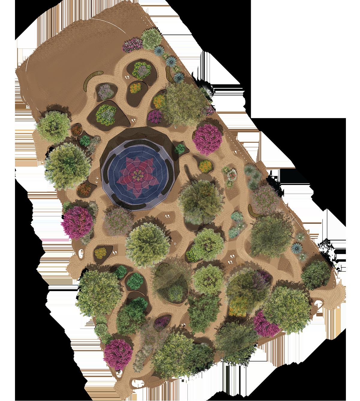
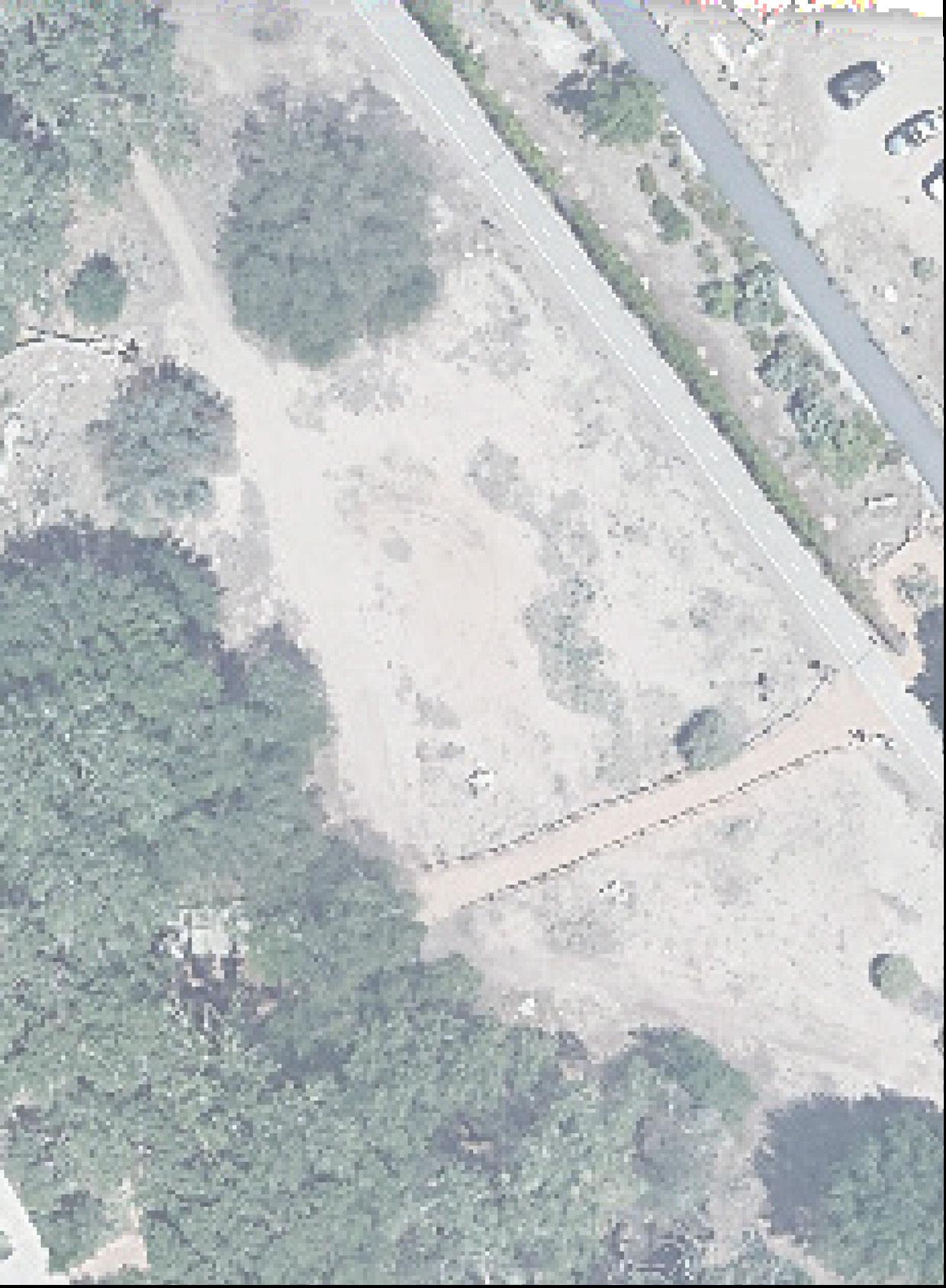
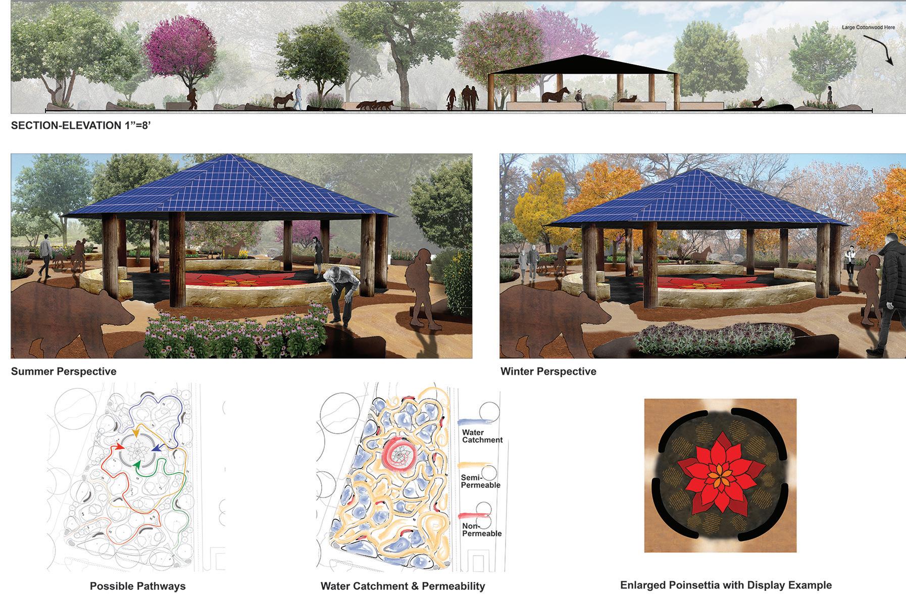
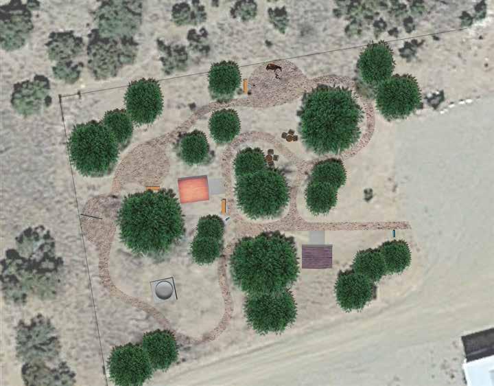
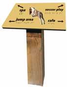
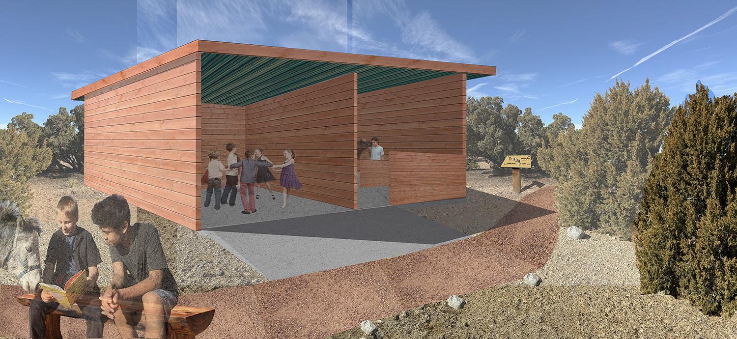
Equine Therapy Center, 2024
Client: My Little Horse Listener
My Little Horse Listener is an equineassisted learning center for children with special needs using miniature horses and donkeys. The client requested an area for the children to take their companion horses for one-on-one time. Children may take their horse on a walk along the trail that winds around and through the site, or groom them at the “spa.” They can play soccer with their animals (who have all learned to “play soccer,” pushing the ball around with their muzzles), and leap low obstacles at the jumping site. A central structure provides a place for educational events or shelter from the rain and wind.