Rock The ROCO Rock The ROCO
4 RIVERS | 3 LAKES
YOU’RE IN A GOOD PLACE... TO GO WITH THE FLOW!
Welcome to the Blueway! This is your perfect getaway to explore nature. Create your own adventure. Take a leisurely float or a thrill-seeking ride down rapids. With a number of access points and variety of trips, your paddling experience can last a few hours or several days. On the RoCo Blueway, we’ve got an outdoor adventure for everyone. So, pack a picnic. Bring along the family. And get ready to ROCK THE ROCO!
n

Know Before you go Know Before you go
• READ MAPS, PLAN AHEAD, AND PREPARE! You will not return where you put in. You will need to have transportation ready at your take out point.
• KNOW THE WATERS YOU PLAN TO FLOAT OR BOAT, AND AVOID WATER CONDITIONS THAT ARE BEYOND YOUR SKILL LEVEL.
• WHERE ARE YOUR PUT IN AND TAKE OUT SPOTS? Have you shared these with others? Some accesses are primitive.
• NOT READY TO FLY SOLO? NEED TRIP SUGGESTIONS? SHUTTLE SERVICES? CONTACT OUR OUTFITTERS LISTED ON PAGE 27.
kcehc w a t e r levels a
d rive r c o n snoitid
Safety Tips Safety Tips
All water experiences are at your own risk. Any form of water activity can be dangerous and can result in personal injury, property damage, or death. Know the risks and your skill level before getting in the water. These tips will ensure a much safer and enjoyable water experience:
• PLAN AHEAD.
• KEEP AN EYE ON THE WEATHER.
• DO NOT GO NEAR THE DAMS! Your safety depends on following all posted safety regulations, warnings, and suggestions.
• BUDDY SYSTEM. Never wade, tube, swim, or boat alone. Go with someone who knows the river and/or lake.
• LIFE JACKET REQUIRED. Essential for fishing, wading, tubing, swimming, or boating on moving water.
• CHECK YOUR GEAR. Dress appropriately and protect your feet. Take a spare paddle, first aid kit, rain gear, sunscreen, sunglasses, a wide brim hat, insect repellent, etc. Put extra clothing, gear, and food in water proof bags. Bring ample water.
• WATCH OUT! Avoid downed trees (strainers), sharp rocks, and other river hazards.
• BE OFF OF THE WATER BEFORE DARK. Ensure you know the time length of your planned route.
WEAR IT! wlA a y s w ear a l i f e jacket o n t eh etaw r wear it!
LEAVE NO TRACE
Every river trip is different. Always know what is ahead including rapids, dams, and where the next access is located. Check weather and water conditions before hitting the water. Plan Ahead & prepare.
Use a fire pan or designated fire ring for open flame fires. Keep fires small. Gathered wood from the ground instead of breaking tree branches. Burn all wood to ash and take the ash with you. Be Careful with fire.
Stick to trails & overnight right.
Stick to designated trails to and from the water access and durable surfaces on the riverbanks. If choosing to camp along the water, be sure to camp in designated areas.
Keep wildlife wild.
Observe wildlife from a distance. Never feed wildlife. Protect them by storing food and trash securely. When fishing, clean up all lines, hooks, and bait so the wildlife doesn’t get hurt or tangled.
Pack it in...pack it out. Place all trash and food scraps in garbage bags and carry it home. Trash your trash.
Share our trails.
Whether you boat, float, or paddle, people have a range of skill levels and different ideas about enjoying the outdoors. Be mindful of noise level as sound travels better on water. Respect others so that our blueways are welcoming and relaxing for all.
While our rivers and riverbeds have a diverse collection of natural finds, snap a picture to remember them by instead of removing them. Leave rocks, shells, and critters where you find them. Leave it as you find it.
Outdoor


It's easy to support Rockingham County Trails; tag us in your social media by using @visitrockinghamcountync #VisitRoCoNC #YearoftheTrail
The Dan River is North Carolina’s favorite “Lazy River”! This slow-moving and leisurely river is well-suited for paddlers of any skill level and is an adventure filled with the unique historic and natural sights of Rockingham County. As the river progresses, paddlers can see fossils that have been dated to over 200 million years ago, as well as the remains of villages inhabited by the Saura people. Additionally, the Dan River is the only remaining place in North Carolina to see remnants of the Batteau system, which used the shallow draft-bottomed craft for commercial river transportation during the 1800’s.
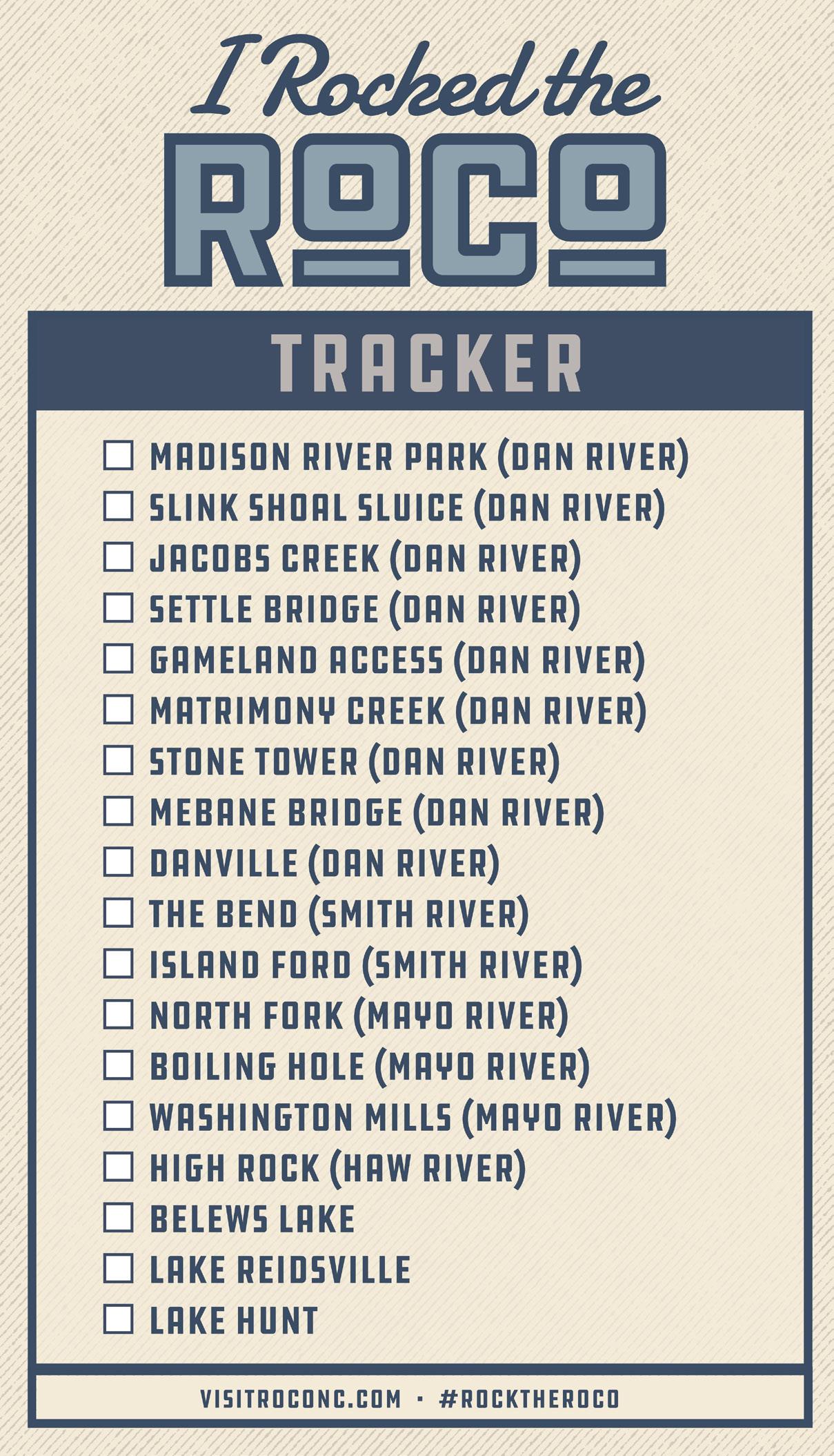
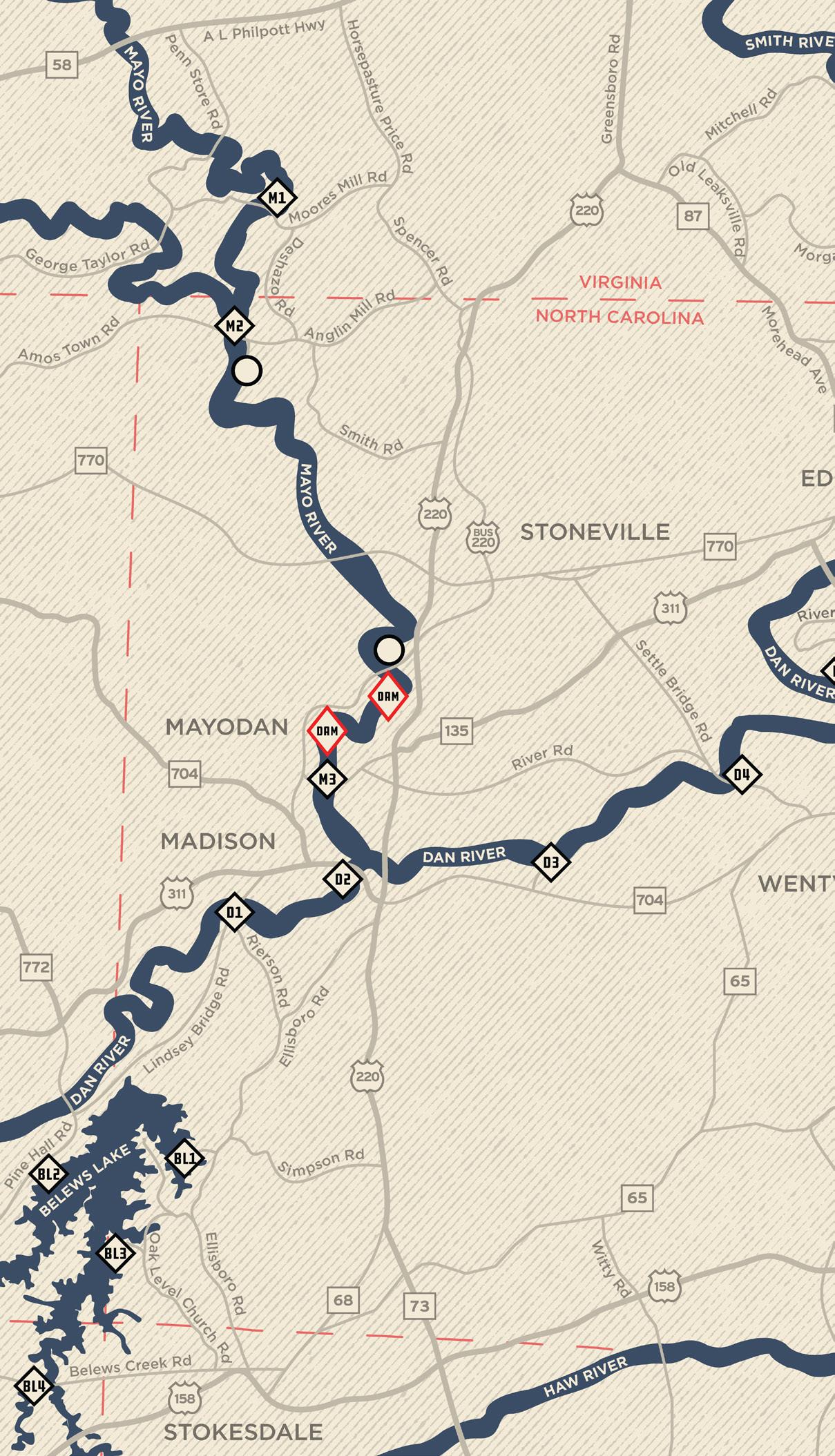
3 – JACOBS CREEK 4 – SETTLE BRIDGE 5 – GAMELAND ACCESS 6 – MATRIMONY CREEK 7 – STONE TOWER 8 – MEBANE BRIDGE 9 – DANVILLE 1 – MADISON RIVER PARK 2 – SLINK SHOAL SLUICE 9 SECTIONS | 49 MILES
VA NC 6 D7 D8 D9
DAN RIVER
This is a perfect section of river for the beginner and experienced alike. Starting at Madison river park, Look out for Ruins of the historic Cape Fear & Yadkin Valley Railroad Bridge and pilings of the old Madison Covered Bridge as you near the end of your trip.
Lindsey Bridge Rd MADISON LINDSEY
NC 704 BRIDGE MADISON RIVER PARK 1 Section 3
HRS/TUBE
River Rd
BRIDGE TO
MILES 1+ HRS/PADDLE 2+
use caution as you navigate near pilings and bridges. Float with a friend and be safe. Beginner Features: Take Out! RIVER LEFT Put In! RIVER RIGHT Put In GPS: 36.3748, -79.9923 | Take Out GPS: 36.3851, -79.9547
the Confluence of Mayo, Lone Island, wing dams, and Slink Shoal Sluice (the “crown jewel” of the historic Dan River batteau navigation system). from the moment you pass under hwy 220 to the take out, there are no bridges, roads, or buildings visible from the river.
River Rd Planters Rd MADISON NC 704
TO
SLINK SHOAL SLUICE 2 Section 4.25 MILES 2+ HRS/PADDLE 4+ HRS/TUBE
BRIDGE
JACOBS CREEK BATTEAU
Pay Attention for shoals and rapids to be navigated safely or avoided altogether. Beginner Features: TakeOut! RIVERRIGHT Put In! RIVERLEFT Put In GPS: 36.3851, -79.9547 | Take Out GPS: 36.3897, -79.8883
JACOBS CREEK BATTEAU TO SETTLE BRIDGE
Throughout this section, remnant structures of the historic Dan River batteau navigation system occur, as well as old native American fish traps. Follow the trail to the metal stairs to use the river access. This site is Listed on the national register of historic places.
SettleBridgeRd RiverRd PlantersRd naD R i verRd TO MADISON TO WENTWORTH
JACOBS
3 Section 4.25 MILES 2+ HRS/PADDLE 4+ HRS/TUBE
CREEK
Pay Attention for shoals and rapids to be navigated safely or avoided altogether. Beginner Features: Take Out! RIVER RIGHT Put In! RIVER RIGHT Put In GPS: 36.3897, -79.8883 | Take Out GPS: 36.4105, -79.8272
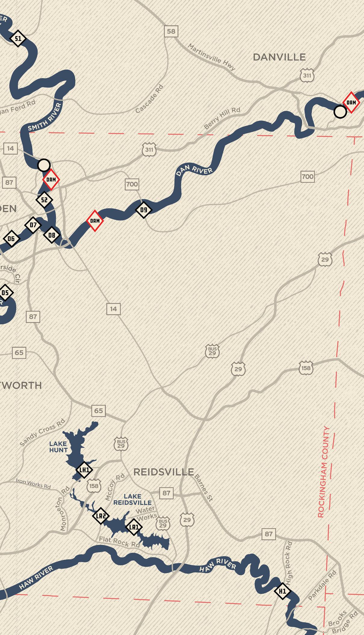
SETTLE BRIDGE TO GAME LAND ACCESS
Eagle Falls Island is about a 1.5 miles from settle bridge. the route left of the island goes through a wing dam and a sluice, & the route to the right features shoals & a series of drops. at the end of this section, the river makes a 180ª turn, which is known as the “bent” just before access on river right.
4 MILES 2+ HRS/PADDLE 4+ HRS/TUBE
River Rd SettleBridge Rd SettleBridge Rd Dan RiverRd EDEN TO MADISON
WoodpeckerRd
Riverside Circle
SETTLE BRIDGE 4 Section
Class ii rapids are Best handled by those who can maneuver boats and read water. Intermediate Features: Take Out! RIVER RIGHT Put In! RIVER RIGHT Put In GPS: 36.4105, -79.8272 | Take Out GPS: 36.4336, -79.7973
this section features several sluice and fish traps structures including gallaways lower fish dam sluice & fish trap, & sneeds strongs fish dam sluice. just past the harrington hwy bridge is a nice little class II drop. major tributaries enter including whetstone creek, buffalo creek, & matrimony creek.
B ethlehem Church Church St Klyce St EDEN Harrington Hwy Riverside Circle WoodpeckerRd GAMELAND ACCESS TO KYLCE STREET GAMELAND ACCESS 5 Section 4 MILES 2+ HRS/PADDLE 4+ HRS/TUBE
Features: Put In! RIVER RIGHT Take Out!RIVERLEFT Put In GPS: 36.4336, -79.7973 | Take Out GPS: 36.4755, -79.7779 Class ii rapids are Best handled by those who can maneuver boats and read water. Intermediate
KLYCE STREET TO LEAKSVILLE LANDING
This section is perfect for a relaxing day on the river to leaksville landing or float through section 7 to the eden wildlife access. Just upriver is a heron rookery. downriver will bring you past the old leaksville water intake and original logs of the 1820 batteau landing.
W King Hwy Beth l eh em Ch urch Rd Church St EDEN Klyce St
MATRIMONY CREEK 6 Section 1
HRS/TUBE
MILES .5+ HRS/PADDLE 1+
Stay Safe: pay attention and always float with a friend even on beginner sections. Beginner Features: Take Out! RIVER LEFT Put In! RIVER LEFT 6 Put In GPS: 36.4755, -79.7779 | Take Out GPS: 36.4855, -79.7637
About .5 mile below the Leaksville Landing is a large stone tower from the 1838 Leaksville Toll Bridge. The Smith river enters on the left before you arrive at the Eden wildlife access on your right. The takeout is just past the powerlines which pass overhead.
W King Hwy Old StateHwy770 Mebane Bridge Rd BethlehemChurch Rd EDEN
EDEN WILDLIFE ACCESS STONE TOWER 7 Section 1.5 MILES 1+ HRS/PADDLE 2+ HRS/TUBE
LEAKSVILLE LANDING TO
Stay Safe: pay attention and always float with a friend even on beginner sections. Beginner Features: Take Out! RIVER RIGHT Put In! RIVERLEFT D7 Put In GPS: 36.4855, -79.7637 | Take Out GPS: 36.4756, -79.7502
This section is not recommended for tubing, and paddling only with a guide is advised. The beautiful arched Mebane Bridge, built in 1924, is just downstream of the put in. You must portage around the duke energy dam. Watch out for signs while on the river.
5 MILES 2+ HRS/PADDLE DON’T/TUBE
follow all
BethlehemChurch Rd EDEN SummitRd E Aiken Rd M o r gan Rd
DRAPER
8 Section
EDEN WILDLIFE ACCESS TO
LANDING MEBANE BRIDGE
Get out! walk around. Do not float over the dam. Death or serious injury will result. Intermediate Features: Take Out! RIVER RIGHT Put In! RIVER RIGHT Put In GPS: 36.4756, -79.7502 | Take Out GPS: 36.4988, -79.6813 D8 Look
out
around the dam! NEVER GO OVER A DAM-Death
injury will result.
for and
dam signs and warnings. Get
and walk
or serious
Keep right for the easiest run on the first shoals. There are several batteau sluices, native American fish traps, an important heron rookery, and several 200 million-year-old rock formations. The large Adam’s island is a great halfway stop to stretch your legs.
21.5 MILES 9+ HRS/PADDLE TOO LONG/TUBE
Cascade Rd BerryHillBridgeRd TO EDEN DANVILLE, VA
ABREU-GROGAN
VA DANVILLE 9 Section
DRAPER LANDING TO
PARK,
Do Not tube! This is a long float with shoals and rapids. Get out before the dam! Intermediate Features: 58 29 58 29 Put In! RIVER RIGHT Take Out! RIVER RIGHT VA NC Put In GPS: 36.4988, -79.6813 | Take Out GPS: 36.5751, -79.4343 D9
SMITH RIVER
2 SECTIONS | 14 MILES
The Smith River is a beautiful destination along the NC/VA border. This section of the river benefits from a regular inflow of crystal-clear, cold water from a neighboring VA dam, which helps maintain temperatures for the Smith’s population of wild brown trout. This stretch of river is a scenic and unobstructed paddle, free from development and home to growing populations of Osprey and Bald Eagle. It winds through Rockingham County for its final five miles before joining the Dan River.
1 – THE BEND 2 – ISLAND FORD
VA NC
MITCHELL ROAD TO 3 RIVER OUTFITTERS ACCESS
In this wide and beautiful section, watch for bald eagles, osprey and more as you head around the bend from Henry County,
into Eden, NC. Takeout is privately owned by troublesome creek outfitters just upstream from the spray dam - so watch out!
Put In! RIVER LEFT
MoreheadAve MitchellRd Morgan Ford Rd OldLeaksvi l l e dR NVan Buren Rd Old State H w y 8 7 M o r gan Rd EAiken Rd Summit Rd Features: 12 MILES 4+ HRS/PADDLE TOO LONG/TUBE EXTREME Danger! Get out before the dam! Contact 3 river outfitters to use take out. Beginner
THE
1 Section
BEND
TakeOut! RIVERRIGHT Put In GPS: 36.6022, -79.7763 | Take Out: Contact 3 River Outfitters VA NC
VA
W Kings Hwy N P i erce S t BethlehemChurch Rd Mebane OldStateHwy 87 Church St RiverDr Bridge Rd ISLAND FORD TO LEAKSVILLE WILDLIFE ACCESS ISLAND
2 Section Put In! RIVER LEFT Take Out! RIVER RIGHT
2 MILES 1+ HRS/PADDLE 2+ HRS/TUBE Stay Safe: pay attention and always float with a friend even on beginner sections. Beginner Put In GPS: 36.5020, -79.7566 | Take Out GPS: 36.4756, -79.7502
FORD
Features: With great parking and easy access, This section is short but sweet. The huge Ford Island starts the trip and takes you right through the heart of Eden, NC before merging with the Dan river. This float is sure to be a smith river special!
MAYO RIVER
3 SECTIONS | 21.5 MILES
If you’re looking to conquer rushing rapids, the Mayo River is the perfect choice! Experienced paddlers will find thrilling Class II and III rapids in the northernmost section of the river. The following sections of the river smooth out into slower waters as the Mayo winds through western Rockingham County until it converges with the Dan River.
The Mayo flows through a scenic gorge featuring rock bluffs and two natural waterfalls. Paddlers can catch glimpses of history through the well-preserved fish traps (weirs) placed by early Native American inhabitants, as well as dams used to generate power during America’s industrial revolution.
1 – NORTH FORK 2 – BOILING HOLE 3 – WASHINGTON MILLS
VA NC
MOORES MILL, VA TO ANGLIN MILL BRIDGE NORTH FORK
Byrd's Ledge is a class II rapid, marking the border of NC and VA. The most challenging section is "The Grand Staircase," a series of ledges across the river just below the confluence with the South Mayo, which is part of the Mayo River State Park. Put In GPS:
6 MILES 2+ HRS/PADDLE 5+ HRS/TUBE
parking at the Moore’s mill access is very limited! Shuttle is HIGHLY recommended.
Moores Mill Rd
Put In! RIVER LEFT
Ge o r g e TaylorRd Anglin Mill Rd Deshazo MillRd VA NC TO STONEVILLE
1 Section
Features:
Intermediate
Class ii rapids are Best handled by those who can maneuver boats and read water.
Take Out! RIVER LEFT
36.5680,
GPS: 36.5353, -79.9909
-79.9860 | Take Out
.
Features: this section includes a beach area and Class III rapid “Boiling Hole” which may be portaged using the mayo beach road access Or Run the rapids, get out, and do it again. For th e full trip, get out at the bus. 221 overpass before the 2 dams downstream!
Mayo Bea c h Smith Rd AnglinMillRd STONEVILLE ANGLIN MILL BRIDGE TO 220 BUS. BRIDGE BOILING HOLE 2 Section 9.5 MILES 4+ HRS/PADDLE TOO LONG/TUBE
Take Out!RIVERLEFT Put In! RIVER LEFT EXTREME CAUTION, class iii rapids are for experts. Get out before the dams downstream! Advanced AccessRIVERLEFT Put In GPS: 36.5353, -79.9909 | Take Out GPS: 36.4388, -79.9379
Features: Joining the Dan river 1.5 miles in, this trip offers quite a lot. you’ll float past sluices, wing dams, shoals, rapids, and even a large island. the remains of the old Batteau navigation system make it possible for beginners to navigate the shoals and rapids.
Settle Bridge R d Priddy Loop Planters Rd TOEDEN TO MADISON STONEVILLE NC-135 ACCESS TO JACOBS CREEK BATTEAU WASHINGTON MILLS 3 Section 6 MILES 2+ HRS/PADDLE 4+/TUBE
Take Out! RIVER RIGHT Put In! RIVER LEFT Pay Attention for shoals and rapids to be navigated safely or avoided altogether. Beginner Put In GPS: 36.4073, -79.9650 | Take Out GPS: 36.3897, -79.8883
Haw RIVER
1 SECTION | 3 MILES
Visitors to the Haw enjoy the many recreation opportunities found on and around the river, including hiking, paddling, swimming, fishing, and picnicking, as well as the solitude and quiet that can be found in many secluded stretches.
Paddlers will enjoy a trip through the history of the region as they move along the river. Reminders of previous inhabitants can be seen in the form of 1000 year-old Native American fish traps, ruins of 18th century grist mills (some of these are rumored to have been stations on the Underground Railroad!), and numerous textile mills built during the Industrial Revolution – many that have been transformed and revitalized for new purposes.
1 – HIGH ROCK
HIGH ROCK
HIGH ROCK ACCESS TO BROOKS BRIDGE
Access is located at the High Rock Ford Historical Site, an important American Revolutionary War site. It is also the site of one of the earliest known grain mills in Rockingham County. The access has a short hiking/walking trail with a small gravel parking lot.
Troxler Mill Rd ParkdaleRd High Rock Rd BrooksBridgeRd Troxler Mill Rd R un ningCreekRd Kernodle Rd TO REIDSVILLE
Dam is Very Close to the take-out. Pay attention and be ready to exit river left! Beginner Features:
1 Section
3 MILES 1+ HRS/PADDLE 2+ HRS/TUBE
PutIn! RIVERLEFT TakeOut! RIVERLEFT Put In GPS: 36.2519, -79.5640 | Take Out GPS: 36.2229, -79.5434
Belews Lake
BL1 - Carolina Marina: GPS 36.3034, -80.0121
BL2 - Pine Hall Double Boat Ramp: GPS 36.2999, -80.0533
BL3 - Humphrey’s Ridge: GPS 36.2826, -80.0303
BL4 - Piney Blu : GPS 36.2416, -80.0636
Belews Lake is a large reservoir formed from Belews Creek, a small tributary of the Dan River. Water-lovers of all types can be found on Belews Lake; swimming, tubing, fishing, paddling, boating, and jet-skiing are all encouraged on the nearly 4,000 surface acres and 88 miles of shoreline. After extensive cleanup efforts in the 1980s and ‘90s, Belews Lake is some of the cleanest water in North Carolina and has a healthy and abundant fish population (much enjoyed by area anglers!). Its central Piedmont location, friendly marinas, and warm waters make Belews Lake a popular place.
Oak Level Church Rd
Pine Hal l R d Lind se y B r i gd e R d Belews CreekRd E l l i bsoro R d
Lake Reidsville
LR1 - Lake Reidsville Park: GPS 36.2938, -79.6824
LR2 - McCoy Rd Access: 36.2971, -79.7068
Lake Reidsville is 750 acres of pure fun; offering fishing, boating, water-skiing, hunting, picnicking, and more to area residents and visitors alike. Since it serves as the primary water source for the surrounding area, swimming is off-limits in Lake Reidsville. Anglers flock to the small inlets and coves around the lake hoping to catch a record-breaking big bass, crappie, bream, or other fresh-water fish, with fishing tournaments held regularly. Lake Reidsville is also a stop on the NC Birding Trail! Visitors may be able to spot Goldfinches, Prairie Wobbles, Yellow Breasted Chat, Indigo Bunting, wintering waterfowl, Red Tail Hawks and Great Blue Herons, just to name a few.
Water Works McCoyRd FlatRockRd
Lake Hunt
Lake Hunt is a small reservoir located just outside of Reidsville, perfect for a quiet day spent paddling in the calm water or fishing for its abundant Black Bass, Crappie, and Yellow Perch populations. An annual pass is required to use Lake Hunt and can be obtained by calling 336.349.4738.
Cro s s R d
Sandy
IronWorksRd
LH1 - Lake Hunt Iron Works Rd Access: GPS 36.3261, -79.7221
Fish: Birds:
BLUEGILL
SMALLMOUTH BASS
LARGEMOUTH BASS
CHANNEL CATFISH
STRIPED BASS
ROANOKE LOGPERCH*
BROWN TROUT
ORANGEFIN MADTORN
Mammals:
WHITETAIL DEER
BEAVER
RIVER OTTER
Insects:
RED TAILED HAWK BALD EAGLE*
BLUE HERON
WOOD DUCK
BARRED OWL
RAVEN
CARDINAL WILD TURKEY
MALLARD
Plants:
VIRGINIA CUP PLANT GOLDENSEAL MOUNTAIN LAUREL
More:
LADYBUG
*NOTE: ENDANGERED SPECIES
Roanoke Logperch:
SALAMANDER
LIZARD
CRAYFISH
FRESHWATER MUSSEL*
Fun Fact: In North Carolina, the Roanoke Logperch is only found in the Dan, Mayo, and Smith watersheds. This large darter can be identified by the distinctive orange stripe that runs across the first dorsal fin. Classified as a state and federally endangered species, the Roanoke Logperch is especially threatened by dams, which interrupt their river journey. Environmental advocates have begun working with dam owners to remove dams that are no longer in use to help restore Roanoke Logperch populations.
RED FOX SQUIRREL
DRAGONFLY BUTTERFLY
TURTLE FROG
Lake Reidsville 630 Water Works Rd, Reidsville (336) 349-4738 www.riseupreidsville.com (rentals for Lake Reidsville only) Mayodan Outdoor Sports 100 East Main St, Mayodan (336) 548-6296 www.mayodanoutdoorsports.com Troublesome creek Outfitters 413 Church St, Eden (336) 627-6215 www.troublesomecreek.com Mad Town Tubing 110 W. Water Street, Madison 336-548-2789 www.madtowntubing.com Dan River Outfitters and Glamping 4890 NC 704 STE. A, Madison 336-916-7070 www.danriveroutfitters.com Outfitters & Rentals: Outfitters & Rentals: Carolina Marina 548 Shelton Rd, Stokesdale (336) 427-0498 www.carolinamarina.com