Ryan Bailey
Postgraduate Landscape Architecture Portfolio
Leeds School of Art, Architecture and Design
Leeds Beckett University
2014 - 2016

L A R y a n M i c h a e l G e o r g e B a i l e y - L a n d s c a p e A r c h i t e c t
R M G B -


I consider myself to be a highly motivated individual with a keen interest in design, producing creative, challenging and technically resolved designs.
This approach to my work has been influenced through my educational background, having focused on small scale design prior to commencing my BA and MA degrees in Landscape Architecture.
My experiences at this early stage in my career have provided me with a wealth of knowledge, having worked on schemes including; public realm regeneration, Quarry restoration, residential developments, green infrastructure surveys, ground condition surveys and campus designs during my Year-out at LUC, London and on my Masters degree course.
Whilst studying I have been an important member of the university, teaching AutoCAD and Adobe suite classes to Landscape Architecture students at various levels of their studies. These lessons have been integral to their study and understanding of the design process. The lessons provide both a basic and more detailed understanding of different software available and how these design tools can be used when developing designs and presenting ideas.
I am looking to gain employment within a multidisciplinary Landscape Architecture practice, hoping to become a valuable member of the team able to contribute to the production of sensitive, sustainable and functional designs solutions.
A short extract ABOUT ME
Ryan M G Bailey
n b t e a United Kingdom
49 Aruba, Gotts Road, Leeds, West Yorkshire, LS12 1DW
06.03.1992 07930586679 rmgbla@gmail.com
Education
MA Landscape Architecture // Pg Dip - Distinction
Leeds Beckett University School of Art Architecture and Design
Cities Alive - Discovering the connection of Amsterdam Noord
Post-Industrial Rehabilitation - Springfields Country Park
Professional Studies - Introduction into the professional contracts
Personal Focus Studio - Leeds Walk-able Cities Framework Strategy
BA Landscape Architecture // First class honours degree
Leeds Beckett University School of Art Architecture and Design
Design and Community Project - Woodbridge Estate Re-development
York City Beautiful - Contemporary City Park
Art and Design Foundation // Merit
Bucks New University
Provided me with a well-rounded experience into the Arts
Contemporary explorations using mixed media
Personal focus towards 3D - Design and the early stages of Landscape
Btec 3-Dimensional Design // Distinction, Distinction, Merit
Amersham and Wycombe College
Development and Understanding of small scale objects and spaces
Furniture design and construction
Small scale spaces and exhibition design explorations


A brief overview of education, experiences and awards
2014 // Asset Skills Bursary - An award of £1000 for Design and Community project team Achievements
2016 // Landscape Institute Postgraduate award in recognition of outstanding project work
2013// Certificate of Recognition - 2nd Year BA Hons Landscape Architecture
Employment


AutoCAD and Adobe Suite Teaching and Support School of Art Architecture and Design Leeds Beckett University
Teaching classes of 1st and 2nd year Landscape Architecture students ranging from 6 to 24 pupils.
Providing a basic overview and more detailed lessons into the Adobe suite, AutoCAD and Sketch-Up
Lessons included; Photomontages, visualisation techniques, Basic overview of AutoCAD and commands and sketch design to CAD through to more detailed design drawings.
Year out Landscape Architect London (Land Use Consultants) LUC
This provided me with a rewarding and invaluable experience within a multidisciplinary consultancy. Throughout the year I developed my skills and knowledge as a designer, working alongside Landscape Architects, Landscape Managers, Planners and Ecologists.
Phoebes Landscapes
Catford, London Landscape Garden Construction
Summer work experience enhancing my construction knowledge and attending client meetings. Gardens on a range of scales from small intimate gardens to large scale gardens.
cv
Software Skills Adobe Photoshop Adobe InDesign Adobe Illustrator AutoCAD Sketch up
University Masters
Year Out Experience
University Undergraduate
Cities Alive
Establishing Amsterdam Noord
Major Design
Springfields Quarry Rehabilitation
Marlowe Road
A mixed tenure housing development - Walthamstow, London
Rochester Residential Development
New outline masterplan for waterside housing development
Acton
Residential Development Detailing
Hart GI Audit
Green infrastructure audit of the county of Hart
Hyde Park Ground Condition Survey Events Space Ground Condition Surveys
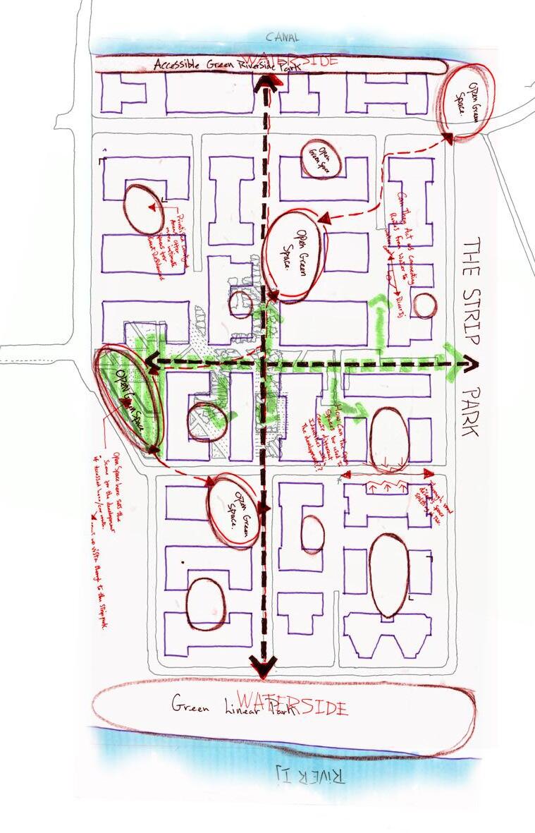
York Civic Park
contents

MA
AMSTERDAM NOORD
Bridging the north and south divide

The cities alive brief focused on the regeneration of the north of Amsterdam and possible connections to the city centre in the south. Amsterdam noord is segregated from the city centre by the expansive river IJ with frequent ferry trips transporting commuters across from the city.
This project established new bridge connections along the north shore of Amsterdam, whilst integrating green infrastructure into existing and proposed developments in the north.
The Overhoeks masterplan achieves high quality residential and working environments alongside the river IJ with green infrastructure at the forefront of all design decisions. This design thinking provides the development with attractive and friendly communities enveloped in high quality pedestrian friendly green spaces.

overhoeks masterplan
Providing high quality residential developments


Hand-drawn residential street and courtyard concepts


Hand-drawn residential concept development


residential development
Integrating green spaces and transport connectivity
The residential design has been developed with the creation of high quality pedestrian friendly networks in mind. The connection of the Buiksloterkanaal in the north-west with the river IJ in the south-west achieves this design thinking through a main pedestrian boulevard which promotes amenity value through its rich and vibrant green spaces and interspersed public and private courtyards. The intersecting tram route offers sustainable door to door connections along the north shore of Amsterdam, running from east to west.
Space Private Space Private Space Public Space Public Space Public Space Public Space Pedestrian and tram through routes Public and private space strategy
Private
live work neighbourhoods
Promoting a green living and working environment
The buildings have been designed in a way which allows maximum pedestrian permeability to the waters edge. This achieves a rich hierarchy of spaces running alongside the canal and office blocks. Smaller courtyards provide intimate spaces which are set back from the canals edge. This green space provides a pedestrian only waterside connection to the northern tip of the site.
The buildings feature a mix of green and brown roofscapes which improve the sites sustainability and amenity value for the residents and workers, whilst building height relationships have been designed to reduce the buildings dominance within the landscape.

 Ground Floor Working Environment Floors Above Provide Living Accommodation
1. Maximum urban volume
2. Pedestrian and vehicle priority
3. Pedestrian access to the waterfront
Ground Floor Working Environment Floors Above Provide Living Accommodation
1. Maximum urban volume
2. Pedestrian and vehicle priority
3. Pedestrian access to the waterfront


WindFarmEnergyPrivateResidence Allotments BrownRoofsand SolarFarms Private/PublicRecreationalGreens
4. Human scale, open space and parking
5. Finalised building heights

Seating to Granite Upstand
Granite Paving Strips - Dark
Granite Paving - Light
Specimen Trees and Seating
Self Binding Gravel and Tree Grove
Large Recliner Benches
Stepped Level Change
Canal
Green Roof
1 2 2 3 4 5 6 Mixed Use Development 1 2 3 4 5 6 7 8 9 10 11 Formal Tree Planting
Parking
Cycle


1 2 7 8 9 10 11 DetailSection

MA
Quarry progression
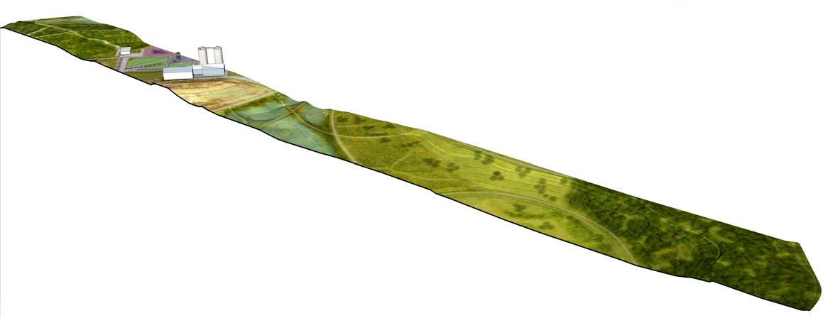
A post industrial quarry rehabilitation programme springfields country park
The proposed rehabilitation scheme for Springfields Farm Quarry redefines the way councils approach the reclamation of quarries.
The design builds itself around the quarries ever evolving landscape, laying the foundations for the application of a progressive restoration scheme. The restoration scheme plans to progressively integrate people and nature with the quarry throughout it’s working life through 6 phases. This application exploites the quarries day to day activities and dominant features, drawing people into the park, unearthing the concealed landscape within it’s boundaries.

GREENING THE
BROWNFIELDS
Phase 1 - Landscape and quarry (upper wetlands)

Shelter
Landfill Cell 2
Landfill Cell 3
Quarry Basin Basin Bank
Amenity Grassland
Lower Wetlands
Upper Wetlands
Coppice Grove
Shelter Planting
Planting
Entrance Walk
Discovery Deck
Visitor Centre
Mounds Way
Swale Strip
Meadow Link
Dipple Extension
Landfill Cell 1
The ‘Springfields Country Park’ proposal aims to reinvigorate the working quarry based on it’s four main principals of;
country park masterplan
Quarry rehabilitation programme
1. Creating a new country park within Beaconsfield, serving the growing population and wider communities.
2. Employing a succinct phasing scheme to introduce the park to visitors at an earlier stage in the quarries planned lifespan.
3. Creating ecologically rich habitats for the safe establishment of nature within the quarry.
4. Providing an innovative and educational restoration scheme which captures the publics attention, attracting visitors to the park.


Birch Coppice Shelter Wood Specialist Horticulture Quarry Retainment Wetland Zone wildflower Meadow Quarry Basin Woodland Extension
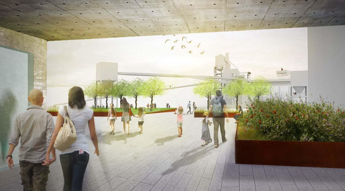
retained buildings and structures
Enhanced industrial environments reference the sites former use
The Country Park proposals employ an enhancement strategy which re-uses existing buildings and structures, restoring, re-cladding and re-purposing them for assimilation within the parkland setting. The buildings and structures will retain much of their existing character, allowing the retention of the quarries industrial past, administering a new lease of life.
The main quarry building and silos will form the main focal point of the park, creating a point of reference for visitors, but also a notable insight into the landscapes past environment. The building itself will be renovated and expanded, creating opportunities for the visitor centre which will be home to an information point, the quarries educational transformation exhibition, gallery spaces and a cafe and eatery.
The existing secondary structures on-site will see the transformation from quarry machinery to observation towers with integrated play spaces.


Views strategy and technical resolution observation
platforms
observation platform
Technical detailing
OP2 (Observation Platform 2) has been the focus for the decking exploration within the technical resolution and aims to showcase how it’s form and function can be achieved through construction, suitably chosen materials and engaging design detailing.


3000 100 1176 205 1006 100 1800 200 200
70
200 50 50 50 20 30 25 70 5 5 30 40 70 min 180 max Countersunk anti-tamper screws
Solid deck
Cor-ten signage Stainless steel frame Structural I beam column 1:20 Detail section showing decking structure, balustrade and signage.
Cor-ten steel balustrade detailinformation plaques
Cor-ten steel balustrade detailViewing window
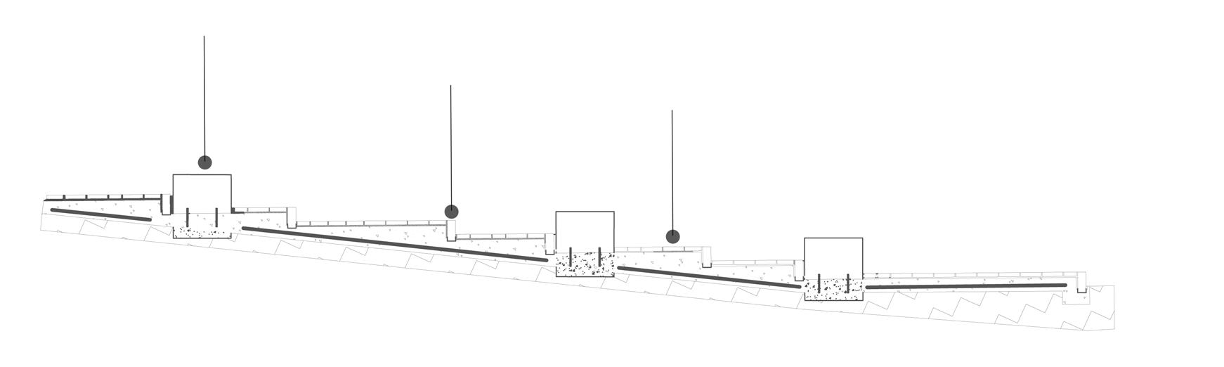
site sections - upper wetlands to mounds way
Level change exploration and retaining features


Waste mounds way paths
140 600 450 750 40 300 10 80 140 70 Pre-cast concrete with honed coarse aggregate seating 20 80 150 25 300 5 100 40 550 150 450 450 100 5 20 405 385 140560 40 300 450 740 450 400 400 50 R197.84 R729.65 50 20 80 150 25 300 5 100 150 450 450 100 5 20 405 385 140560 40 300 450 740 450 400 400 50 R197.84 R729.65 50
Gabion basket retaining seating
coppice walk
Sequential biennial coppicing management
Sequential biennial coppicing management regime employing a 12 year rotation cycle around a primary and secondary ride system.
Primary rides - also providing main path routes
Secondary rides - Informal paths
Year of cutting
Indicative non-coppice areas comprising multi-stem and standard trees

Marginal/Aquatic Planting
Multi-stem walk
1 9 5 7 11 9 3 11 3 1 1 7 5 3 key: 1 9 7 11 3 1 1 7 5 3 9 5 7 11 9 3 11 3 1 1 7 1 9 5 7 11 9 11 3 1 1 7 5 3 1 9 7 11 3 1 1 7 5 3 1 9 5 7 11 9 3 11 3 1 1 7 5 3
Glade
Tree Planting
Species (Latin Name)
Betula Pendula
Betula Pendula
Betula utilis jacquemontii
Betula utilis jacquemontii
Betula utilis jacquemontii
Corylus Avellana
Corylus Avellana
Corylus Avellana
Castanea Sativa
Castanea Sativa
Understory Planting
Species
(Latin Name)
Anemone nemorosa
Allium ursinum
Brachypodium sylvaticum
Dryopteris filix-mas
Euphorbia amygdaloides robbiae
Hyacinthoides non-scripta
Luzula sylvatica ‘Marginata’
Luzula pilosa
Polystichum setiferum
Woodland
Species (Common Name)
Silver Birch
Silver Birch
Himalayan Birch
Himalayan Birch
Himalayan Birch
Hazel
Hazel
Hazel
Sweet Chestnut
Sweet Chestnut
Fully furnished: Rootballed
Fully furnished feather: bareroot
Fully furnished: Rootballed
Fully furnished: Rootballed
Multi Stemmed: Rootballed
Multi Stemmed: Rootballed
Multi Stemmed: Rootballed
Feather: Bareroot
Transplant 1+1: Bareroot
Whip: 1 break
Species (Common Name) Specification
Wood anemone
Wild Garlic
Wood brome
Male fern
Mrs Robb’s Bonnet
Bluebell
Great
Hairy wood-rush
Soft shield fern
- 2.5m Min.
- 0.8m Min.

Ultimate - 0.3-0.9m
- 1.5 x 1.0m
- 0.5 x 0.5m
Ultimate - 0.5 x 0.5m
- 0.3m
- 0.5 x 1.5m Ultimate - 1.5 x 1.0m
Height Girth
Specification
1.8
3.0m
2.0
1.5
0.6
1.5m
3.5m Min. 3.5
4.0m Min. N/A 12 - 14cm N/A N/A N/A N/A N/A 14 - 16cm N/A
- 2.4m Min.
Min.
- 2.5m Min. 0.6 - 0.8m Min.
Min.
-
4.0m
14
Min.
- 16cm
Height and Spread
1L Pot 50cc
established root Seed 1L Pot 2L Pot 2L Pot 2L Pot 1L Pot 1L Pot Ultimate
0.5m Ultimate
0.5m Ultimate
Ultimate
Ultimate
Ultimate
wood rush
min. Plug:
- 0.5 x
- 0.5 x
Birch Buffer
Coppice
ecological buffer zones
Safe areas for habitats to thrive away from human interaction
The ‘ecological buffer zones’ have been designed into the parkland as ‘safe areas’ for wildlife. These are areas not intended for any anthropogenic use, but are instead reserved for the preservation of plants and nature. Fig C shows the indicative location of this area within the retained quarry areas. This diagrams depicts how the ‘ecological buffer zones’ are intended to function and how they will be integrated into the parkland.
Within the retained quarrying area main pathways have been provided to encourage human interaction within the landscape (fig B), however, these do not encroach on the quarries edge allowing the creation of a ‘buffer zone’. Informal pathways have been designed to encourage user exploration away from the buffer zones.
 Fig A - Schematic Diagram showing ecological buffer zone and decking walkway
Fig B - Decking walkway route character
Fig A - Schematic Diagram showing ecological buffer zone and decking walkway
Fig B - Decking walkway route character
 Fig C - Schematic Diagram showing ecological buffer zone in quarry area
ecological habitat creation
Retain existing quarry setting
Through the feasibility study and research carried out for the site it was found that Sand Martins are popular inhabitants of quarries and sightings have already been made at Springfields Farm Quarry. It was therefore imperative that Sand Martins nests were to be catered for in the design of the country park and that their habitats were not designed out.
This has been achieved through artificially created nests within the quarries banks encouraging wildlife, creating suitable and stable habitats for the Sand Martin colonies.

Location Plan


Nest detail

1:100 Section - Typical quarry sand bank with Sand Martin nests installed
JAN DEC FEB MAR APR MAY JUN JUL AUG SEP OCT NOV SPRING SUMMER AUTMN
Nesting Season
PROFESSIONAL PRACTICE


marlowe road
Mixed residential housing, Walthamstow, London
Programme
A new development in the north-east of London, providing a mixed tenure residential scheme comprising shared streets, an integrated public plaza with ground floor amenities such as shops and a cafe and a play area to the south.
Responsibilities
Throughout this project I assisted on site visits, client and community member meetings, site analysis, masterplan drawings, renderings and planning details which all fed into the Design and Access report.

The masterplan
Mixed tenure residential and public realm

Plan view - Totem signage and bollards

Section - Totem signage

PROFESSIONAL PRACTICE

Under bridge connection to
Roman wall conserved/enhanced
Arches cafe and terrace
Vintage point
Acorn wharf screen planting
M.U.G.A
Land art
Active arches - arches
Castle
Hotel
Hotel,
Proposed
Creative uses
New
New
Historic
Natural
Wetlands/attenuation
Furrell’s view
Boardwalk
Entrance
Undercroft
1 12 23 24 2 13 3 14 4 15 5 16 6 17 7 18 8 19 9 20 10 21 11 22
Esplanade Key:
multi-story parking
parking Intertidal habitats
railway station
pedestrian underpass
crane
park
play
developed
view business park
and restaurant
Lookout
restaurant and bar
totem

ROCHESTER RIVERSIDE
A waterside development comprising 1500 new dwellings
Programme
Outline planning masterplan for a mixed tenure development of roughly 1500 new dwellings in a waterside location just north of Maidstone on the east coast of England.
Responsibilities
This project required a fast turnaround for the provision of a landscape masterplan and rendering which was required for an outline planning application for the development. The landscape consisted of both private and public open spaces which are characterised by the sites riverside setting, creek formations and industrial character.


PROFESSIONAL PRACTICE
600 Concrete haunch to Engineer's detail Resin Bound Gravel Step Tread infill Handrail posts formed of reclaimed railway sleepers Product: Untreated Reclaimed Tropical Azobe Hardwood Sleepers - Grade A to match timber walls Size:2600mm x 250mm x 150mm Timberplay holding rope threaded and secured through pre-drilled sleeper posts Reclaimed railway sleeper step treads Product: Untreated Reclaimed Tropical Azobe Hardwood Sleepers - Grade A to match wall detail Size:1000mm x 250mm x 150mm 150 150 14.85 16.05 Reclaimed railway sleepers retaining wall to rear. Refer to DET-621 Reclaimed railway sleeper retaining wallRefer to DET-621 600 Richter Spielgerate Slide Product no. 3.63340 H1800mm x W1000mm x L3500mm 3500 1800 Concrete haunch to Engineer's detail 16.05 14.25 TOW 16.65 Timber 6137-LD-DET-627 Timber sleeper wall Type 2 6137-LD-DET-621 WEST PARK Sand Carpet Play Surface. 6137-LD-DET-610 01 Section G-G 1:25 @A1 02 Section H-H 1:25 @A1 600 Concrete haunch to Engineer's detail Resin Bound Gravel Step Tread infill Handrail posts formed of reclaimed railway sleepers Product: Untreated Reclaimed Tropical Azobe Hardwood Sleepers - Grade A to match timber walls Size:2600mm x 250mm x 150mm Timberplay holding rope threaded and secured through pre-drilled sleeper posts Reclaimed railway sleeper step treads Product: Untreated Reclaimed Tropical Azobe Hardwood Sleepers - Grade A to match wall detail Size:1000mm x 250mm x 150mm 150 150 14.85 16.05 Reclaimed railway sleepers retaining wall to rear. Refer to DET-621 Reclaimed railway sleeper retaining wallRefer to DET-621 600 Richter Spielgerate Slide Product no. 3.63340 H1800mm x W1000mm x L3500mm 3500 1800 Concrete haunch to Engineer's detail 16.05 14.25 TOW 16.65 Timber 6137-LD-DET-627 Timber sleeper wall Type 2 6137-LD-DET-621 WEST PARK Sand Carpet Play Surface. 6137-LD-DET-610 01 Section G-G 1:25 @A1
acton phase 7
Acton phase 7 residential detailing
Programme
Acton Phase 7 forms an area of a much larger housing development in West London. The housing development encompasses mixed tenure housing with high quality public spaces.
Responsibilities
Within this project I was involved in the process of compiling drawings which would feed into a Stage E construction detailing package. Within the detailing for this site I looked into the construction of the ‘play mounds’ through the use of reclaimed railway sleepers (left) and various paving build-ups across the development (below),
Reclaimed railway sleeper retaining wallRefer to DET-621 600 15.25 14.50 knee rail 6137-LD-DET-627 Highways works to CTP detail ADOPTABLE HIGHWAY B-B D-D F-F H-H G-G C-C E-E A-A Notes: 1. Do not scale from this drawing. 2. All dimensions must be checked on site and any discrepancies verified with landscape architect. 3. All dimensions are drawn in mm. 4. Landscape drawing only. 5. All materials/items used to be as specified or alternatives to be approved by landscape architect. P1 23.06.15First Issue JBMFMF NORTH LONDON NW1 1JD T: 020 7383 5784 43 Chalton Street london@landuse.co.uk F: 020 7383 4798 Title Client Project www.landuse.co.uk Iss Date Issue Notes Acton Gardens Phase 4 Acton Gardens LLP Landscape Sections S:\6100\6137 Acton Gardens, Phase 4\B Project Working\Drawings\XRefs\ACTON_GARDENS_Logo_GREY-OLIVE.jpg C1 20.07.15CONSTRUCTION ISSUE JBMFMF Reclaimed railway sleeper retaining wallRefer to DET-621 600 15.25 14.50 Timber knee rail 6137-LD-DET-627 Highways works to CTP detail ADOPTABLE HIGHWAY B-B D-D F-F H-H G-G C-C E-E A-A Notes: 1. Do not scale from this drawing. 2. All dimensions must be checked on site and any discrepancies verified with landscape architect. 3. All dimensions are drawn in mm. 4. Landscape drawing only. 5. All materials/items used to be as specified or alternatives to be approved by landscape architect. P1 23.06.15First Issue JBMFMF NORTH LONDON NW1 1JD T: 020 7383 5784 43 Chalton Street london@landuse.co.uk F: 020 7383 4798 Iss Date Issue Notes By By By S:\6100\6137 Acton Gardens, Phase 4\B Project Working\Drawings\XRefs\ACTON_GARDENS_Logo_GREY-OLIVE.jpg C1 20.07.15CONSTRUCTION ISSUE JBMFMF Pressure impregnated timber softwood board 50 x 150mm fixed with galvanised nails to 50 x 50 x 450mm softwood pegs driven into the ground at 1200mm centres. Minimum 75mm depth loose gravel. Graded 10-12mm 150mm Type 1 sub-base. To Engineer's Detail Geo-Textile Membrane 250 Building DPC Level 150 BUILDING EDGE ACO MultiDrain MD Brickslot galvanised steel slot drain or similar approved ACO MultiDrain MD 100mm channel with inclusive Brickslot access maintenance unit Footing to engineers specification Geotextile membrane Q20 170 PRIVATE ADOPTABLE PRIVATE ADOPTABLE ACO MultiDrain MD Brickslot galvanised steel slot drain or similar approved ACO MultiDrain MD 100mm channel with inclusive Brickslot access maintenance unit Footing to engineers specification Geotextile membrane Q20 170 15075 Slot Drain to Slab Paving (Q10.150) @A1 02 Detail - Slot Drain to Clay Brick Paving (Q10.150) 1:10 @A1 Gravel Margin to Building @A1 PRIVATE ADOPTABLE ACO MultiDrain MD Brickslot galvanised steel slot drain or similar approved ACO MultiDrain MD 100mm channel with inclusive Brickslot access maintenance unit Footing to engineers specification Geotextile membrane Q20 170 01 Detail - Slot Drain to Slab Paving (Q10.150) 1:10 @A1

HART GI AUDIT
A green infrastructure audit for the district of Hart
Programme
Hart green infrastructure audit saw the assessment of all it’s open green spaces and areas of recreation.
Responsibilities
This project saw the assessment of over 200 green spaces within the District of Hart. Using the form below myself and my colleague visited the District for 6 days and assessed these open spaces based on the principals set out in the forms below. Within this time we quickly built up


Date of audit: Surveyor: Photo ref: Field Assessment 1. Welcoming: 17. Conservation of natural features, wild fauna, flora: 18. Conservation of landscape features: 19. Conservation of buildings & structures: 20. Structural townscape role: 11. Litter & waste management: 12. Grounds maintenance and horticulture: 13. Building & infrastructure maintenance: 23. Marketing & promotion: 24. Provision of appropriate information : 25. Provision of appropriate educational/ information: 6. Safe equipment & facilities: 7. Personal security in open space: 8. Dog fouling: 9. Appropriate provision of facilities: 10. Quality of facilities: 21. Community involvement in management & development: 22. Appropriate provision for community: 14. Environmentally sustainability: 15. Waste minermisation: 16. Arboriculture & woodland management: Scoring line: 1 Very poor 4 Good 2 Poor 5 Very good 3 Fair 6 Excellent A: Welcoming place E: Conservation and heritage C: Clean and well maintained G: Marketing B: Healthy, safe and secure F: Community involvement H: Comments D: Sustainability Time spent surveying: Survey site access: (whole site/ part site/ no access) Map ref: 2. Good and safe access: 3. Signage: 4. Equal access for all: 5. Site access: (freely accessible (V+5), restricted access (V+2), no public access (V-1), opening hours (V+2), other(V 0)) Play area assessment
PROFESSIONAL PRACTICE

BA Hons
York civic park
Flood alleviation parkland
York civic park envisaged a new park within the city located at the historic monument of Cliffords Tower.
York is susceptible to yearly floods from the rivers bursting their banks and the parks positioning at the confluence of the River Ouse and Foss meant that the park had to be capable of dealing with frequent flooding. Design solutions included a series of wetlands and a skatepark basin that was capable of storing flood water.

1 : 150 scale axonometric drawing
Granite Paving Specified sizes
GRA921 Black granite flamed texture
Bespoke Seating element
Granite setts
100 x 100 x 200
GRA903 mid grey granite flamed texture


activating the waters edge
Designing for human interaction with the waters edge
Bespoke Seating element
Granite setts
100 x 100 x 200
GRA903 mid grey granite flamed texture

Granite Paving
GRA921 Black granite flamed texture
1 : 50 scale section

