Ashley Reynolds Urban Planning Portfolio

Table of Contents Resume 4 8 14 18 24 28 Anderson Township Downtown Site Hamilton Ave in 2050 Thematic Map Exploration of Tools
Cities have the capability of providing something for everybody, only because, and only when, they are created by everybody.
- Jane Jacobs
Hello! My name is Ashley Reynolds. I am from Liberty Township, Ohio. Ever since I can remember, I have been captivated by the power of planning. I firmly believe that meticulous preparation and thoughtful consideration can pave the way for positive change on a global scale. Whether it’s tackling environmental issues, advocating for social justice, or promoting sustainable development, my ultimate goal is to leave a lasting impact and contribute to a brighter future for all.


4
Philanthropy Painting Hiking Skills Interpersonal Adobe Suite Mapping Additional • AutoCAD • InDesign • Photoshop • Illustrator • Acrobat • Premier Pro • SketchUp • Technical Writing • Google Earth Pro What inspires me: • StoryMap • ArcGIS Pro • ArcMap • Verbal Communication • Conflict Resolution • Collaboration • VRay Contact Me! (513)913-0592 reynoah@mail.uc.edu LinkedIn: Ashley Reynolds 413 Southview Drive Cincinnati, Ohio
Interests
Resume Experience
Planning and Zoning Co-Op | Anderson Township
Education
University of Cincinnati | Cincinnati, Ohio
College of Design, Architecture, Art, and Planning
Bachelor of Urban Planning
GPA: 3.421 | Class of 2026
Participating in the Professional Practice Program, alternating semesters of classroom study with work in the field of planning + design.
Lakota East High School | Liberty Township, Ohio
High Honors Diploma
GPA: 4.122 | Class of 2021
Awards + Activities
Dean’s List | Fall 2021-Present
National Honors Society | 2020-2021
Youth in Philanthropy | August 2018-May 2021
• Co-Chair • Treasurer
Member
Full Time | Anderson Twp, Ohio
January 2023-April 2023
• Assisted in reviewing and analyzing zoning regulations, land use plans, and development proposals to ensure compliance with local ordinances and regulations.
• Conducted research on planning and zoning issues, including demographic data, economic trends, and environmental considerations, to support decision making-processes.
• Collaborated with planning department staff and other stakeholders to develop and update comprehensive land use plans and zoning ordinances.
• Assisted in the preparation and presentation of reports, presentations, and recommendations to township officials and public meetings.
• Assisted in coordinating public engagement efforts, such as community workshops and surveys, to gather input on land use and developmental issues.
• Stayed updated on current trends, best practices, and legislative changes in planning and zoning to ensure compliance and effectiveness in job responsibilities.
Swim Instructor | Goldfish Swim School
March 2019-August 2022
Part Time | West Chester, Ohio
• Instructed individuals of varying ages and skill levels in swimming techniques and water safety.
• Created and implemented lesson plans tailored to the specific needs and abilities of each student
• Ensured a safe and controlled environment during swim lessons, adhering to established safety protocols and emergency procedures.
• Developed positive and supportive relationships with students and their parents or guardians, fostering a comfortable and engaging learning atmosphere.
•
Anderson Township Planning and Zoning Spring 2023
6
Trails & Walkways Plan
Anderson Township Road Jurisdictions
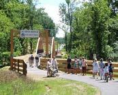
The biggest project that I undertook during my time with Anderson Township was updating the Trails & Walkways plan. Formerly a 70 page document, I gave it a much needed word diet and rewrote passages where necessary. The document was reduced to around 40 pages total. I was also tasked with redesigning the entire document as well as creating new maps and graphics to make it easier to understand for the general public.
The Anderson Township Trails & Walkways Plan has not been finished. However, if you click on the cover photo it will take you to everything that I completed before I finished my Co-Op with them.

Trails & Walkways
DRAFT VERSION UPDATED May 2023
8 Anderson Trails - May 2023 Draft 6
ODOT (Ohio Department of Transportation)
Hamilton County
Anderson Township
Date:
I-275 I-275 SR 52 SR52 F i v e Mile R d Clough Rd SR32 SR32 SR 125 SR 125 E ig h t M i le Rd E ig h t M i le Rd Beechmont Avenue
Source: CAGIS
April, 2023
Batavia Road
Kellogg Road
Anderson Township
Introduction
The 1993 Anderson Township Transportation Plan and the 1986 Sidewalk Plan identified the need for walkways, bike ways, and trails to facilitate non-vehicular movement and provide ready access to locations such as schools, post office, parks, retail centers, libraries, recreational facilities, health centers, and mass transportation.
As a legacy of the Anderson Township Bicentennial celebration, the Anderson Trails concept recognized the need and began the process to provide the links to connect desired destinations with areas which have existing walkways or are otherwise regarded as safe for pedestrians or bicyclists. Another goal of the Anderson Trails Program is improvement of the quality of life and community spirit by allowing leisurely movement between neighborhoods.
When this plan was first assembled by the volunteer Transportation Advisory Committee (TAC) in the spring of 1998, the intent was to identify and record specific possible sites from the general recommendations in the earlier Transportation Plan. Locations were inspected and data was gathered to determine the benefits that new walkways, bike ways, or trails would provide to the residents.
The completion of more than 30 projects over almost 25 years has resulted in positive feedback from citizens. Township and Park District surveys and comments by individuals indicate strong demand for the opportunity to safely enjoy leisure or recreational walking or bicycling. The completed sections have improved commercial access to facilities and “liberated” people from confined neighborhoods. To date, over 25 miles of sidewalks and trails have been built since the levy was passed in 1998. In addition, the Township is currently engaged in sidewalk projects throughout the community.
Many residential subdivisions, long existing as well as newly developed, have sidewalks constructed by the developer. Also, zoning regulations are in place requiring sidewalks on commercial properties for new construction or redevelopment. For the best utilization of these sidewalks, links between them are necessary. Those which are most needed are along the older roads maintained by Hamilton County and which are key parts of the roadway network for the Township residents and businesses.
The entities responsible for road maintenance are shown on the map on the next page. To date, walkways along those important connections have been achieved only by Township initiated action and funding.
The Anderson Trails Plan Subcommittee of the Anderson Transportation Advisory Committee (TAC) has reviewed the 2018 Update to the Anderson Trails Plan document taking into account comments from the public as requested in the Anderson Insights newsletter, the Anderson Township Facebook page and from e-mail and phone calls. The Subcommittee also considered geographical balance in the development of the recommendations contained in the Anderson Trails Plan Priority Ranking Report as well as developing the plan with the concept of getting the “biggest bang for the buck”, meaning the greatest number of residents gain access to specific destinations or other neighborhoods for the least cost. This plan forms the TAC’s suggestions for trails improvements over the next 5 years, in an effort to continue the implementation.
Anderson Township Trails & Walkways Goals
Developed on the basis of 1999 forecast of needs, the original plan was intended as a long range guide to help progressively improve walkway infrastructure by integration into annual planning and funding decisions and other opportunities prompted by related infrastructure improvements or land developments.
To provide a starting point for the comprehensive long range plan, the original document included an initial list of locations where linkage walkways could give high benefit to cost ratios. Such a list is included in this plan as well, for even as projects require professional services for design and costs estimates before funding of each, preliminary cost estimates provide a comparison of locations and for indication of magnitude of funding a long range plan.
Anderson Trails - May 2023 Draft 4
1. Integration of walkways into ALL planning as the Township develops and evolves, consistent with the 1986 Sidewalk Plan
2. Development of a plan for on-going funding of this type of infrastructure improvements.
3. Creation of public recognition of the benefit and support of funding methods which may be developed.
2023 Draft 5
Anderson Trails - May
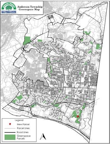
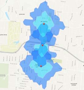
The map above was created in ArcGIS Pro and Illustrator. It shows a new greenspace parcel that has been donated to their greenspace program. This was published on Anderson’s website as well as their Facebook page.

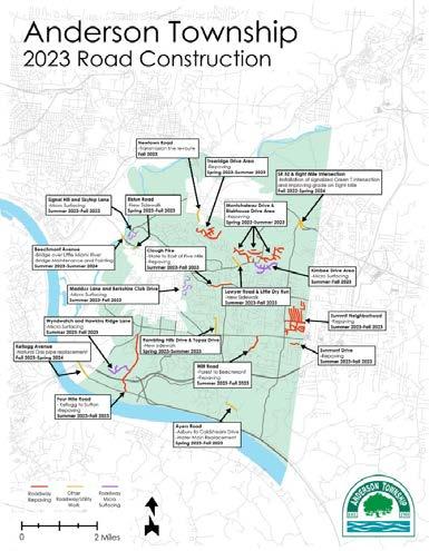
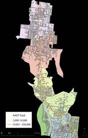
The map below was created with ArcGIS Pro and Illustrator. The map was published on the Anderson Township website to inform the public which roads were going to have construction in 2023 and what type of construction it was.
2023 Draft
Hamilton Avenue BRT in 2050
Summer Studio - 2023
12

North College Hill & Mt. Healthy
The point of this project was to look at the Bus Rapid Transit Route that is proposed to be implemented on Hamilton Avenue through the lens of a neighborhood scale. My neighborhoods were North College Hill and Mt. Healthy. On this page are some of the graphics I created to help describe what the two neighborhoods are like currently.
14 Walking Driving Number of Trips Parking Ride Share Bus Sustainability Accessibility Safety Mobility Reliability Emissions Carpooling Roadway Design Commute time and distance Law Enforcement Timing Level of Service Sidewalk Quality Cost Efficiency ADA Qualification Convenience Biking
14
BRT Site Masterplan


The masterplan of the site that connects Mt. Healthy and North College Hill
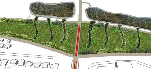
The above slide and the collage on the right show a proposed redesign that incorporates the BRT on Hamilton Ave and what can be done with Ronald Reagan Highway. In 2050 the highway will be turned into a boulevard because there will be less dependence on private cars.
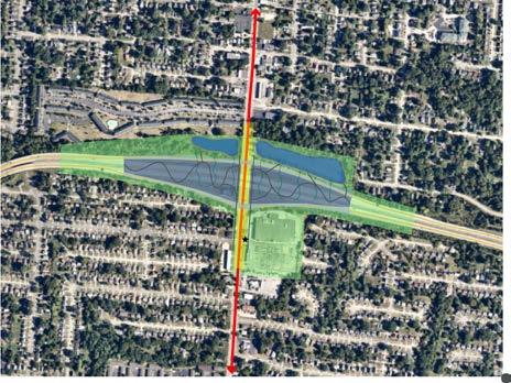
Legend BRT Stop BRT Line Bioswales Natural restoration park Sidewalks R.R. Hwy BRT
Water Retention Pond Permeable Pavers Bioswales
Bioswales
Native Plants Sidewalks
Downtown Cincy Site Planning Fall
Studio - 2022
16

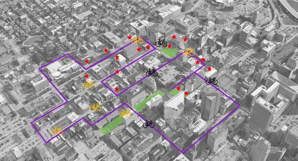
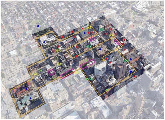
Downtown Cincinnati Mural Trail
For the fall studio, we split into groups and chose a focus area to improve in Cincinnati. Our group decided to create a mural trail that connects numerous murals located downtown to each other in a 2.5 mile long trail. The project utilized Google Earth Pro, ArcGIS Pro, Illustrator, InDesign, and SketchUp.

First impressions
18
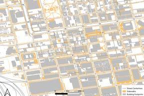
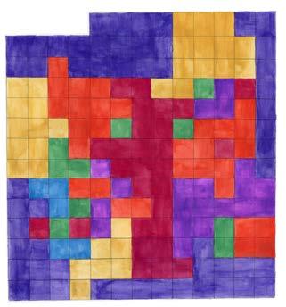
PLAN 2011 SITE PLANNING & DESIGN FALL 22 Instructor: Hyesun Jeong (TA: Mohit Raut) School of Planning D A A | P This map of the sidewalks Downtown Cincinnati depict the walkability area. From the map that the area is walkable due to the abundance sidewalks and the virtually topography. MURAL School of Planning D | A | A | P PROPOSED AREAS MURAL PLAN 2011 SITE PLANNING & DESIGN FALL 22 Instructor: Hyesun Jeong (TA: Mohit Raut) School of Planning D A A P PARKING LOTS AND GARAGES Park ng Lots Bu dings Streets This map shows all of the parking lots and garages located in the downtown site. There are 75 in this area alone. Combined with the whole city of Cincinnati, there are way too many. There is an overabundance of parking
MURAL TRAIL
PLAN 2011 SITE PLANNING & DESIGN
FALL 22 l Instructor: Hyesun Jeong (TA: Mohit Raut)
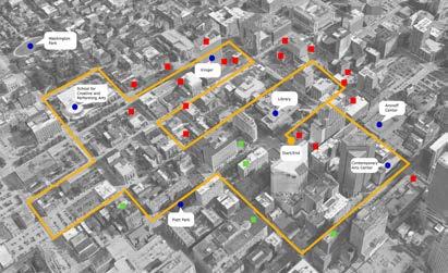
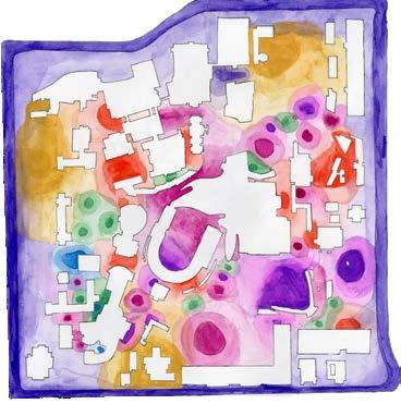
The map on the right shows all the current and future murals that should be along the Mural Trail. It also points out places of cultural significance in the area. These areas are also important to note because of the draw that they bring to the area.
The map on the left is the master plan for the Mural Trail. It shows where all the current murals and bike stations are as well as the proposed stations and murals. It was created using Google Earth Pro, and Illustrator.
This map is the overall proposal for the mural trail. It contains the proposed trail, current and future bike stations, current and future murals, all places of cultural importance, and areas that are future food hotspots.
Mural Route
Future Food Spots
Current Bike Stations
Future Bike Stations
Existing Murals
Future Murals
Cultural Places
WALK/BIKE MURAL TRAIL MURAL TRAIL
Site Planning - Vine Street
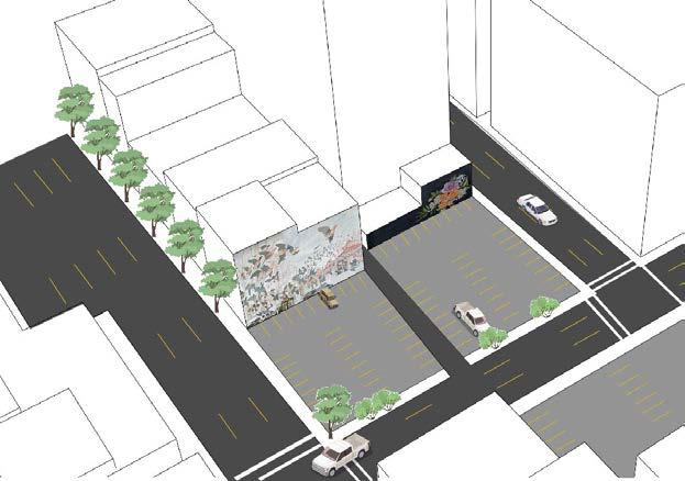
Along the mural trail there is this big block of impervious pavement dedicated to parking. This was an example of substandard urbanism and was a chosen site to redesign and improve.
The model below was created using SketchUp that was then input into Illustrator and Photoshop. It was used to convey what the area currently looks like and why it should be redesigned.
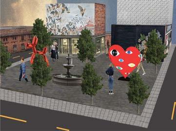
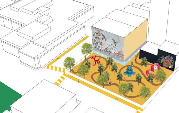
20
The 3d Model above was created using SketchUp, Illustrator, and Photoshop. This is one idea to redesign the parking and impervious pavement into a 3rd place that the surrounding community could enjoy. The collage on the left was created to give an abstract visual as to what the area could look like. The area was proposed to be turned into a statue park.
Sound and Color Thematic Map
Fall Studio - 2021
22
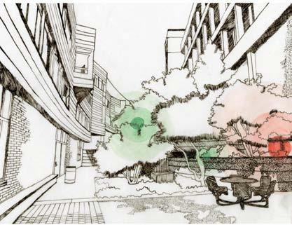
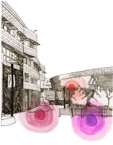
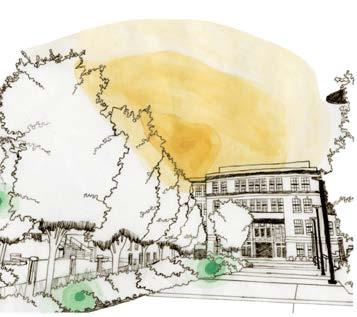
Sound and Color Elements

The idea for this project was to create a thematic map whose main idea was an interest for the creator. I hand drew, and painted everything on this layout. The idea was that everywhere you go on campus, you can hear different sounds when you stop and listen. There were four organizational categories for the different sounds heard across campus.
24
The vignettes above and on the right were hand drawn and painted with watercolor. They show three different areas on campus that had different types of sounds. The colors on the vignettes correspond with the colors on the legend on the map.
Exploration of Tools And Materials
Fall Studio - 2021
26
Tools & Materials
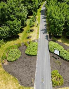
The project below was created using trace paper and a felt tip pen. It was created to emphasize the pedestrian pathways throughout the University of Cincinnati’s campus, as well as the surrounding area. It was fixed in Photoshop.

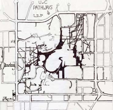
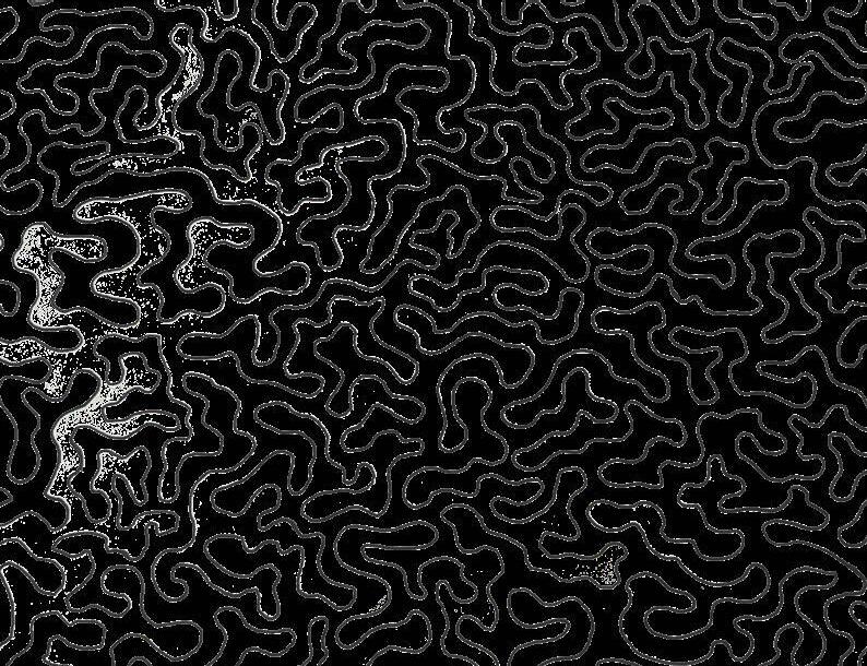
The projects above and on the right were created with trace paper, pencil, and Micron pens. The project started with a topography map and using those lines, create an abstract drawing that has a theme. The drawing above utilized pencil and the drawing on the right utilized Micron Pens. The theme for the drawing on the right was futuristic technology. The theme for the drawing on the top was the meshing of natural and sharp edge design.

28
The created Color They about an sound the bottom but
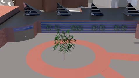
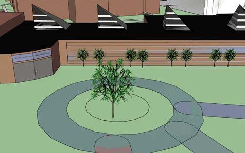
The SketchUp models on the right were created to accompany the Sound and Color Thematic Map shown on page 24. They were created to further knowledge about SketchUp as well as demonstrate an area on campus that creates pleasant sound because the two 3D models show the College Conservatory of Music. The bottom model was created in SketchUp but then rendered in VRay.


Thank You! Ashley Reynolds Urban Planning Portfolio College of Design, Architecture, Art, and Planning reynoah@mail.uc.edu (513)913-0592