International Journal of Engineering Research and Reviews ISSN 2348-697X (Online)
Vol. 10, Issue 1, pp: (31-38), Month: January - March 2022, Available at: www.researchpublish.com

International Journal of Engineering Research and Reviews ISSN 2348-697X (Online)
Vol. 10, Issue 1, pp: (31-38), Month: January - March 2022, Available at: www.researchpublish.com
1Assistant lecturer, Faculty of Engineering, Mataria, Helwan University, Cairo, Egypt
2 Associate Professor, Faculty of Engineering, Mataria, Helwan University, Cairo, Egypt
3 Professor in Groundwater Institute, National Water Research Center, NWRC, Cairo, Egypt
Abstract: Groundwater is an important source of water in desert wadies, where due to aridity conditions and scarcity of surface water, Residents and Bedouins depend on it in their daily lives. Wadi Hodein is one of the largest wadies in the Egyptian Eastern Desert that relying on groundwater abstraction from Nubian Sandstone Aquifer (NSA). There are several shallow wells penetrate the NSA, but the most important deep wells are Abu Saafa and El Dief wells. Bedouins strongly depend on these wells for drinking purpose. The aim of this research is to assess the potentiality of the groundwater aquifer under the present stresses, in order to preserve the sustainability of this essential water resources to ensure the stability of the inhabitants in this important border region in the future. Visual Modflow 3.0. was run to simulate the groundwater conditions in the aquifer. The model was run for 50 years to assess the sustainability of pumping from these wells based on a sensitivity analysis between specific yield and drawdown under the current discharging rates. The results revealed that the existing wells are in the safe side under the current discharge rates and it is highly recommended to keep the discharge from these wells in the range between (5- 20 m3/hr) to avoid water depletions in shallow wells excavated by residents other wise these shallow wells should be deepened.
Keywords: Nubian Sandstone Aquifer (NSA) – Sustainability -Visual Modflow - Sensitivity analysis.
Wadi Hodein is one of the most significant wadis located in the southern part of the Eastern Desert. It is suffering from shortage in fresh water, where the main source of water is the rainwater. Therefore, Bedouins and residents in some regions inside the study area depend on groundwater wells despite its limit potential. To guarantee sustainability of these wells, the potentiality of the groundwater in (NSA) should be assessed.
Few researches deal with groundwater resources in Wadi Hodein due to its very limited available data. (Al Gamal, 2019) worked on groundwater and surface water hydrology management at Halayib and Shalatine sub regions. He used the classical approach of pumping test (Todd & Wiley, 1980) and the non – conventional approach of environmental isotopes for 16 groundwater samples for groundwater hydrology management. The results categorized groundwater into three categories: The first category represents palaeo-groundwater highly depleted in delta values for Santa, Deif, Gederiet and Abu-Saafa wells. The second category, representing groundwater moderately enriched in delta-values for Abu-Ramad, Shelatin, Maadi, Abraq, Nabeit and Aqua-Matar wells. The third category represents groundwater highly enriched in delta values for Gahlia and Omereit wells. (NWRC,2011) studied the groundwater aquifers in wadi Hodein. it concluded that 3 aquifers are existing in the study area with limited storage. Also, it recommended that discharge rate from development wells must not exceed 5m3/hr. (Yousef, et al. 2009) used geologic map, topographic maps, TM satellite image, field observations and measurements to identify the geomorphological characteristics (Land Form and Morphometry), some geological features, hydrogeological and hydro chemical conditions of some wadies south of Shalatine city. The results revealed that the morphometric parameters of the wadis reduce flooding ability and good chance for groundwater recharge. (Ismail, et al. 2006) selected 23 water point from the Basement rock and Nubian sandstone aquifer in Wadi Hodein to evaluate the groundwater resources quantitively and qualitatively. The results showed that the poor groundwater potentiality of the fractured basement aquifer is attributed to the weak chance of infiltration of water during
International Journal of Engineering Research and Reviews ISSN 2348-697X (Online)
Vol. 10, Issue 1, pp: (31-38), Month: January - March 2022, Available at: www.researchpublish.com
surface runoff to replenish the concerned aquifer. In addition, Nubia sandstone aquifer is detected as a water-bearing formation in Wadi Abraq, Abu Saafa and Wadi EL Dif. Also, the research revealed that groundwater quality of the fractured basement aquifer varies from fresh to saline, while in Nubia sandstone aquifer from fresh to brackish. (Gomaa, et al. 2004) concluded that the salinity of the Quaternary aquifer increases from the upstream portions to downstream. On the other hand, there is a variation in groundwater salinity of the Nubia sandstone aquifer from fresh to brackish water type.
Most of the previous researches depends on chemical analysis for groundwater samples and others depend on pumping test to assess the existing groundwater wells. The main objective of this research is to collect the hydrogeological data from the previous researches then integrate it in a mathematical model to simulate the NSA in wadi Hodein to assess the potentiality of the groundwater aquifer under the current discharge rates, in order to preserve the sustainability of this essential water resources.
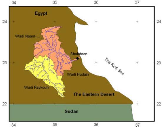
Wadi Hodein is in the southern part of the eastern desert of Egypt, between latitude 220000000, 240000000 N and longitude 340000000, 360000000 E and it covers an area of 11595 km2. Wadi Hodein is considered one of sub catchment of Red sea mountain which drains its runoff water toward Red sea as shown in Figure 1. It is situated in semi-arid to arid region with max rainfall of 10 mm between October to December and almost zero at the rest of the year. The maximum temperature reaches to 37.5 C0 in July and August while the minimum value reaches to 14 C0 in December and January. The Humidity reaches its minimum value of 29% in July and August and the average wind velocity in the study area reaches to about 12 km/hr. (Hassan, et al.2017)

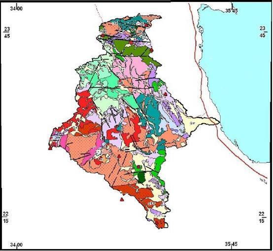
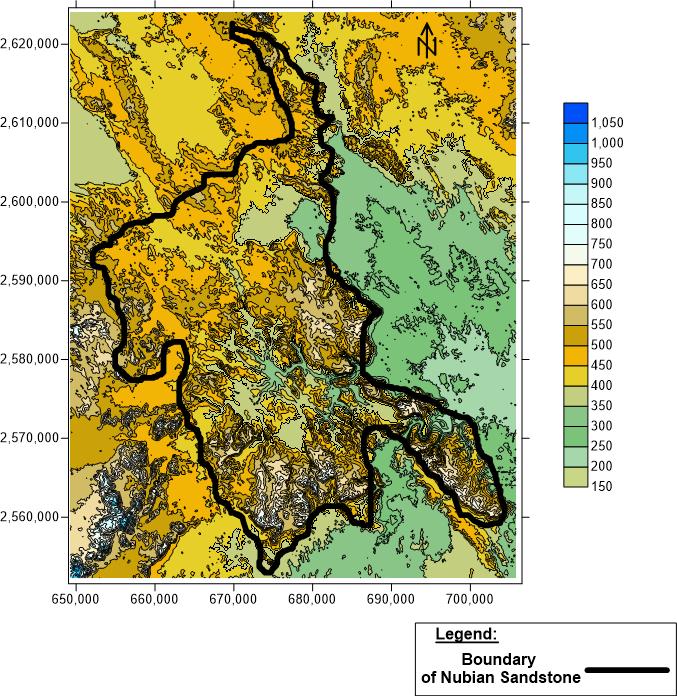
The geology of Wadi Hodein could be divided into three formations; The Precambrian Fractured Basement, The Upper Cretaceous rocks (Nubian Sandstone) and The Quaternary deposits from the oldest to the recent respectively, as shown in Figure 2. Precamberian Rocks are surrounding the study area. They are consisting of metamorphic, granite, calcide, granodiorite, quartezdiroite and volcanic rocks. Upper cretaceous rocks is considered one of the oldest sediementary rocks in wadi Hodein. Upper cretaceous rocks are divided into three formations Umm Barmil, Temsah and Abu Aggag. Quaternary deposits occupy mostly the eastern region of wadi Hodein in addition to the main channels, (Yousef, et al.2009). The under investigated aquifer in this research is the Nubian sandstone aquifer. Regarding Quaternary and Fractured basement aquifers, they are outcropped as the Quaternary aquifer is very shallow aquifer with very limited water potential while the Basement aquifer needs an extensive investigation due to its complicated geological setting.
Pumping test was performed by National Water Research Center (NWRC, 2011) on El Dief Well in NSA. The results estimated that transmissivity of NSA aquifer is about 69.46 m2/day, the storage coefficient is about 4.26 x10⁻⁵ and the hydraulic conductivity is about 0.7 m/day. (Ismail, et al.2006) used the raw data of pumping test performed by (GARPD, 1996) using Jacob straight line to obtain transmissivity of NSA. The results revealed that transmissivity is about 73.31 m2/day.
International Journal of Engineering Research and Reviews ISSN 2348-697X (Online)
Vol. 10, Issue 1, pp: (31-38), Month: January - March 2022, Available at: www.researchpublish.com
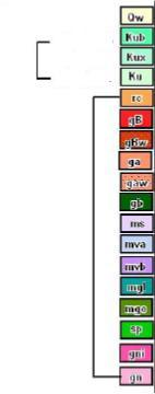
Figure 2: Geologic Map of Wadi Hodein, (NWRC, 2011)
From the previous reviews, Table 1 summarizes the hydrogeological parameters of NSA Table 1: Hydraulic Parameters of NSAS
Hydraulic Parameter Value
Kx , Ky (m/sec) 8.1E-06 Kz 8.1E-07
Specific Yield (Sy) (0.01 to 0.15) Specific Storgae (SS) (0.001 to 0.015)
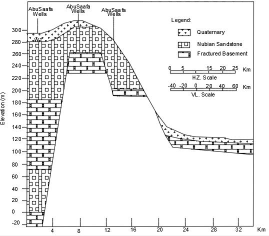
NSA covers the northwestern part of Wadi Hodein. It overlies directly the Fractured Basement rocks as shown in Figure 3. It is formed of fine to coarse sandstone intercalated with clay (Ismail, El Sayed, & Gomaa, 2006) The aquifer acts as independent isolated aquifer (Omar, 2000). Rainfall, flashfloods on the NSA and surrounding Fractures Basement are the main sources of groundwater replenishments
Figure 3: Hydrogeological cross section at AbuSaafa Wells location (Ismail, El Sayed, & Gomaa, 2006)
International Journal of Engineering Research and Reviews ISSN 2348-697X (Online) Vol. 10, Issue 1, pp: (31-38), Month: January - March 2022, Available at: www.researchpublish.com
Many authors investigated the thickness of NSA at different drilled wells. (Ismail, et al.2006, found that water bearing formation of NSA was deteced in Wadi Abraq, Abu Saafa and Wadi El Dif where thickness of NSA at Wadi abu Saafa is about 150m. (NWRC, 2011) stated that thickness of NSA at Wadi Deif is from 32 to 134m. (Gomaa, et al.2001) mentioned that water bearing formation of NSA at Wadi Abraq is about 350m. The groundwater inside NSA exists as a free water table and the main source of aquifer recharge is from direct precipitation during floods (Gomaa, et al.2001).
The mathematical representation of the partial differential equation for transient, one layered, unconfined aquifer in a heterogeneous anisotropic medium is simulated in Equation 1 ( ) ( ) ( )
where Kxx, Kyy, Kzz are values of hydraulic conductivity along the x, y and z coordinate axes LT-1; h is the piezometric head L; W is a volumetric flux per unit volume and represents sources and/or sinks of water T-1; SS is the specific storage of the porous material L-1 and t is time T.
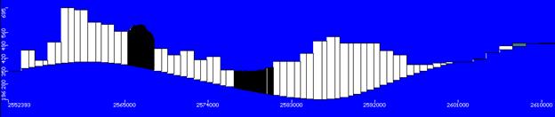
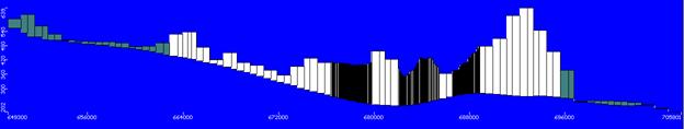
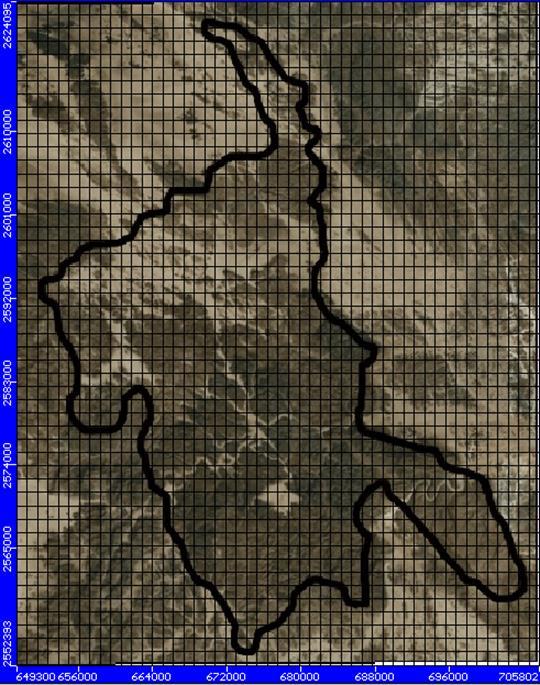
Hydrogeological modeling of NSA required the collection of various data; The ground surface elevation, number of aquifer layers, thickness of each layer, hydrogeological parameters and discharge rates from AbuSaaf and El Dief wells. Ground surface elevations for NSA region was extracted from SRTM DEM 90x90m as shown in Figure 4. Maximum ground elevation at NSA region is attains 770 m above mean sea level on Gabal Kalal at the southern part of NSA region which is near to Dief well, while the minimum ground elevation attains 300 m above mean sea level near from Abu Saafa Wells.
To enable studying groundwater potentiality, the conceptual model of the NSA has been constructed. It was based on both geology and hydrogeology of the concerned aquifer. The NSA in the study area was assumed to be one layer surrounded by Precambrian Fractured Basement rock as shown in Figure 5a. it was also assumed that, there is no vertical hydraulic connection between NSA and the below layer. The aquifer thickness varies over the study area from the literature review,
International Journal of Engineering Research and Reviews ISSN 2348-697X (Online)
Vol. 10, Issue 1, pp: (31-38), Month: January - March 2022, Available at: www.researchpublish.com
the thickness of NSA at the different locations were interpolated to estimate the overall thickness as shown in Figure 5b&6&7. The average thickness of NSA ranges from 150 to 500m.
The groundwater flow direction is locally from the west to the east. The NSA occurs under unconfined conditions. An average initial head of 290 m was taken as a uniformly distributed water head on the whole study area as shown in Figure 5a
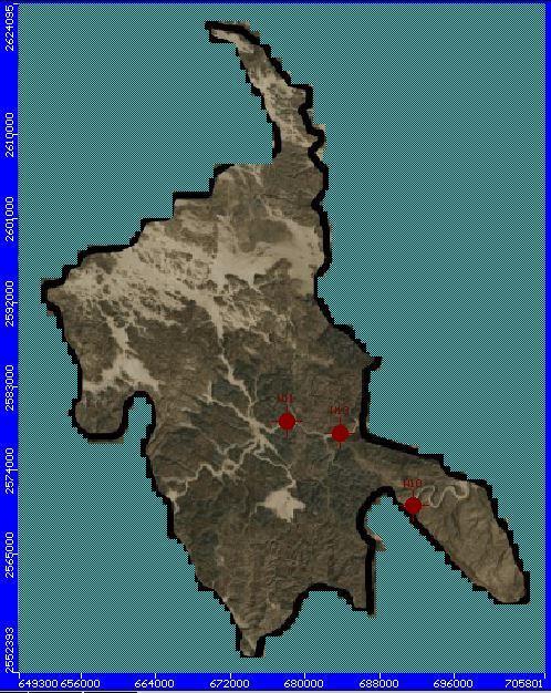
The model domain is divided into 50 row and 50 columns with average cell size of 1130x 1435m as shown in Figure 8a. The cell size was refined at discharge wells location. The discharge wells in NSA are represented in Abu Saafa and Dief Wells. (NWRC, 2011) mentioned that the discharge from Abu Saafa wells ranges between 4.5 to 18 m3/hr with well depths of 90.65 and 33 m, respectively. For Dief well, the discharge is about 20 m3/hr with well depth of 134m as shown in Figure 8b.
Figure
The boundary condition was selected as no flow boundary according to the previous discussion of the hydrogeological setting of the NSA.
The aquifer properties of NSA included the hydraulic conductivity and the specific yield. The aquifer is considered a homogeneous aquifer where the horizotal,vertical hydraulic conductivity are 8.1*10-06 and 8.1*10-07 m/s, respectively. The model was run under a range of Sy from (0.01 to 0.15).
According to the lack of data, due to the absence of groundwater observation wells in the study area, there is no measerments for the fluctutaion of groundwater levels which enable the construction of water level maps. As a result the model calibration in steady state and transient state can not be excuted. Instead an average value of the hydraulic conductivity extracted from pumping test in the study area was used. Moreover a sensitivity analysis between the specific yeild and the corresponding drawdown under the current discharge rates from the studied wells was implemented. The results of the adopted analysis were used to assess the aquifer potentiality and to performe and check the response of the aquifer due to current discharge rates assuming it will be the same for a period of 50 year.
The model was run in transient state for a period of 50 year under the effect of the discharge from Abu Saafa and Dief wells with different specific yield values from (0.001 to 0.15). Drawdown values for each discharge well were plotted versus time for the different specific yield as shown in Figure 9
International Journal of Engineering Research and Reviews ISSN 2348-697X (Online)
Vol. 10, Issue 1, pp: (31-38), Month: January - March 2022, Available at: www.researchpublish.com
(b) (c)
Qw2 = 4.5 m3/hr (Abu Saafa Wells)
0 0.05 0.1 0.15 0.2 0.25 0.3 0 3650 7300 10950 14600 18250 21900
Drawdown (m) Time (Day)
SY = 0.01 SY = 0.05 SY = 0.1 SY = 0.15 0 0.5 1 1.5 2 2.5 3 0 3650 7300 10950 14600 18250 21900
Qw3 = 20 m3/hr (El Dief Wells)
Drawdown (m) Time (Day)
SY = 0.01 SY = 0.05 SY = 0.1 SY = 0.15
From the presented graphs , it can be noticed that the maximum drawdown at Abu saafa wells ranged from 0.27m to 0.91m after 50 year while for the same period, the drawdown at Dief wells reached to maximum value of 2.56 m. The ratio of the drawdown to well depth was calculated in Table 2 to check ratio of well deterioration to guarantee the sustainability of the discharge wells on long term conditions, and to check the sustainability of shallow wells used by Bedwins setteled in the study area
Table 2: Ratio
Well Label Max. Draw Down (m) Well Depth (m) Ratio of Draw Down/Well Depth% W1 0.92 90.65 1.00 W2 0.18 33 0.55 W3 2.56 134 1.9
From Table 2, it can be concluded that for all well’s drawdown ratio to well depth highly less than 50% so these well are in safe side from depletions under the discharge and aquifer conditions. But it may have a negative impact on the shallow wells. Based on (NWRC,2011), the depth of the shallow wells scattered in the study area was not exceed 1.00m, therefore to safeguard the sustainability of pumping from these wells and consequently to ensure life for residents, the drawdown in Abu Saafa and El Dief wells should less than 1.00m. From the above results, the only deep well has the drawdown less than 1.00m is well no (2) which is one of Abu Saafa wells, (0.18m). For considering the future increase in population, the discharge rate form this well was proposed to be increased. The propsed discharge rate was taken 3 time the existing discharge (15m3/hr). The model was run under different values for the specific yield as mentioned before. The drawdown curves was estimated plotted versus time as shown in Figure 10
International Journal of Engineering Research and Reviews ISSN 2348-697X (Online)
Vol. 10, Issue 1, pp: (31-38), Month: January - March 2022, Available at: www.researchpublish.com
Qw2 = 15 m3/hr
1
0.5
1.5 0 3650 7300 10950 14600 18250 21900
Drawdown (m) Time (Day)
0
Sy = 0.01 Sy = 0.05 Sy = 0.1 Sy = 0.15
From Figure 10, it can be concluded that the max drawdown reached 1.07m, which mean that 15m3/hr could be considerd the max. accepted dicharge rate for W2 to avoid the increase in the drawdown values.
Nubian Sand Stone aquifer is considered the main suitable source for groundwater in Wadi Hodein as its water qaulity differ from fresh to brackish. Results of analysis showed that the current discharges from Abu Saafa and El Dief Wells are suitable with the hydrgeological conditions of NSA. It is highly recommended that the discharge from these wells should be in the range of (5- 20 m3/hr) to avoid water depletions in shallow wells excavated by residents, to sustain the deveopmemt from NSA in the future , the shallow wells should be deepened for more than 1.00m specially, in El deif area. In addition, it is recommended to make more investigations in this important region to have an accurate data about the hydrogeological conditions of the Nubian Sandstone aquifer in Wadi Hodein
Journal publication:
[1] Al Gamal, S. A. (2019). An assessment of water resources at Halayib and Shelatine sub regions, southeastern desert, Egypt using conventional and isotopic approaches. International Journal of Hydrology Science and Technology, 201-219.
[2] GARPD. (1996). Lithological and raw data of pumping test of El Dif well. Development, General Authority for Rehailitation Project and Agricultural.
[3] Gomaa, M. A., El Fakharany, M. A., & Eisaa, M. A. (2001). Groundwater Geochemistry of the Quatrenary and Upper Cretaceous Aquifer at Wadi Hodein, SouthEastern Part of Eastern Desert, Egypt. Journal of the Faculty of Education, 471- 493.
[4] Hassan, F. O., Abdel Salam2, A. A., Rashed, H. S., & Faid, A. M. (2017). Land evaluation and suitability of Hala’ib and Shalateen region, Egypt, by integrated. Annals of Agric. Sci., Moshtohor, 151 –162.
[5] Ismail, Y. L., El Sayed, E., & Gomaa, M. A. (2006). Preliminary Hydrogeologic Investigations of Nubia Sandstone and fractured Basement Aquifers in the Area between El Shalateen andHalayeb, Eastern Desert, Egypt. Uranium in the Environment, 619-638.
[6] NWRC. (2011). Study for Water Resources in Some Wadies in Eastern Desert. NWRC.
[7] Todd, D. K., & Wiley. (1980). Groundwater Hydrology. NewYork: Geological Journal.
[8] WRRI. (2011). A study of water resources for some of eastern desert wadies, Red Sea governorate. Water Resources Research Institute.
[9] Yousef, A. F., Salem, A. A., Baraka, A. M., & Aglan, O. S. (2009). The Impact of Geological Setting on the Groundwater Occurences in Some Wadis in Shalatein - Abu Ramada Area, South Eastern Desert, Egypt. European Water, 53-68.
Thesis or dissertation:
[10] Omar, H. H. (2000). "Hydrogeology and hydrogeological studies in Halaib - Shalatein area, Egypt, using remote sensing technology and ither techniques."Ph.D, thesis, Fac.Sci, Ain Shams Univ, Cairo, Egypt,282P.