The Wind Rose and Cartagena Bay During Colonial Times
Cartagena’s Port
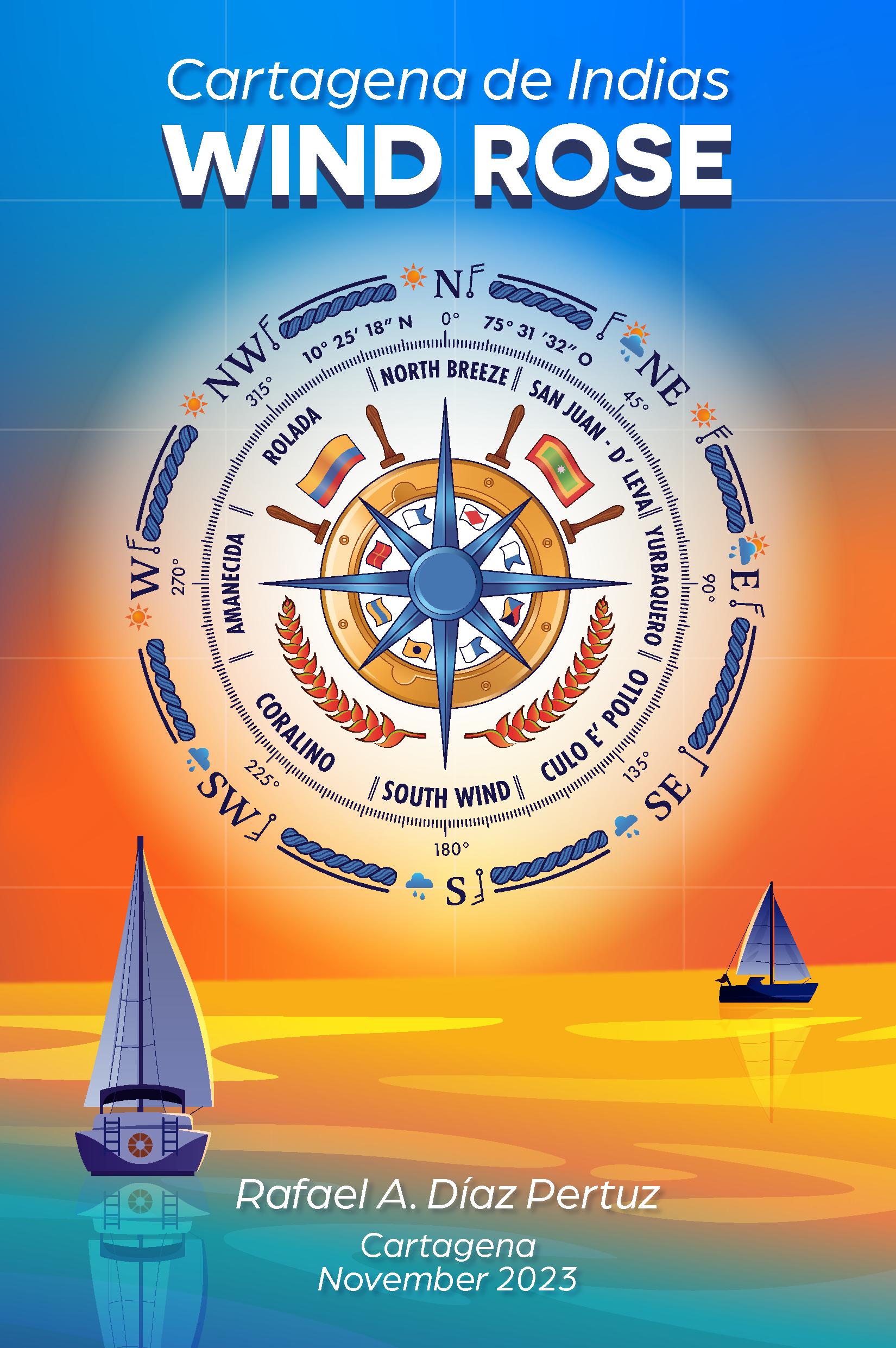
“Cartagena’s Wind Rose” - Illustration
Prevailing Winds: Characteristics and Cultural Stories
“The Rose Twilight” - Illustration
Elements of the “Rose Twilight” Illustration
Cartagena’s Wind Force by Day and Month
Cartagena’s Wind Direction by Hour and Year
INTRODUCTION
It all started on this day...
“We set out on Friday, the 3rd of August, 1492, from the bar of Saltes at eight o’clock; we sailed with a strong wind until sunset towards the South for sixty miles, which are fifteen leagues; then to the Southwest and the South by Southwest, which was the route to the Canary Islands. With these simple words, Columbus (14511506) began his Diary, which contains the most significant voyage of all time as it opened the history of a new world. He embarked on three small ships on a journey in which he had absolute faith.”
Today, more than 530 years later, the Wind Rose of Cartagena de Indias resurfaces in a beautiful illustration for the delight of enthusiasts and curious minds of navigation and the history of Cartagena de Indias.
yages among sailor friends, I’ve always been intrigued by the winds and the names by which they are known, the nautical stories behind them, and how these narratives intertwine with the city’s history since its discovery, colonization, and ancestral native customs.
Driven by curiosity, I embarked on a journey starting from the foundation laid by the creation of the Mediterranean Wind Rose with its eight main winds, now considered fundamental and familiar to sailors and fishermen across all latitudes. The goal was to investigate and compile information about our winds and the climatological characteristics surrounding them and create an illustration that would gather meteorological information useful for sailors, enriched and embellished with details of our geography, culture, history, and other elements that define us, and finally transform it into a national cultural symbol for sea and navigation enthusiasts.
Sailing along the coasts of Cartagena de Indias and its surrounding islands, and participating in fantastic gatherings that occur during and at the end of vo-
The Wind Rose, on a personal level, is an esoteric symbol that refers to a specific desire to stay on the right path, without
INTRODUCTION
deviations, without getting lost, with a fixed gaze on a specific course, much like a navigation compass for sailors. This compass provides a reference line that allows the helmsman to determine the heading of their vessel.
Even though helming a sailboat and enjoying the pleasure of navigating the bay or the coasts of Cartagena de Indias, you can feel the strength of the wind and identify its direction using navigation
instruments such as an anemometer, a weather vane, or a windsock, recognizing the cultural identity of the winds of the “corralito de piedra” through stories filled with experiences of old-time sailors and native inhabitants, will surely be a delight for sailors arriving in these latitudes for the first time, as well as for any visitor Interested in learning about the history of Cartagena and its nautical traditions.
fairwinds between the lines...
WIND ROSE The
Origin and Characteristics
The Wind Rose, in general terms, is a symbol in the shape of a circle that marks thirty-two possible compass points, dividing the circumference of the horizon. Each point corresponds to a wind, with its purposeful name and unique personality. It was invented by the Spaniard Ramon Llull (13th century), based on a description provided by the Italian Pliny the Elder in Book II (1st century).
It has astronomical origins, initially used to determine the position of objects by referencing the stars. This symbol provided information on ancient maps, starting from the location of the North represented by the Fleur-de-lis symbol.
The Wind Rose from the nautical chart of 1504, created by the Portuguese navigator Pedro Reinel, is the earliest known Wind Rose that clearly depicts the fleurde-lis as a symbol of the North. This practice was adopted in other nautical charts and has survived to the present day.
*Raimundo Lulio, a Spanish musician, missionary, Christian evangelizer, and philosopher of Mallorcan origin.
**Pliny the Elder, an Italian writer, naturalist, and military officer of the 1st century. He conducted studies and research on natural, ethnographic, and geographical phenomena, compiled in his work Naturalis Historia, which served as an encyclopedic model of knowledge until the mid-17th century. His studies were later replaced by research based on the Scientific Method and modern Empiricism. Pliny’s works influenced many Western explorers, including Odorico of Pordenone, Marco Polo, Antonio Pigafetta, Christopher Columbus, and Ferdinand Magellan, as well as the Spanish conquistador Hernán Cortés, who matched Pliny’s geographical and ethnological descriptions with their own discoveries, including references to fantastic beings and regions from Greco-Roman mythology.
The Winds Craddle
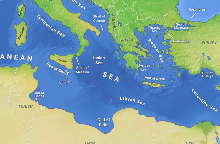
The naming of winds has traditionally referenced a specific point in the Mediterranean region known as “The winds Cradle”, where the direction and names of the winds align. To locate this point, one should find a place where Rome lies to the northwest, Greece to the northeast, Syria to the southeast, and Libya to the southwest. The result is a point halfway between Malta and Crete, precisely where the 20th meridian intersects with the 36th parallel.
Names of Prevailing Winds Around the World
Today, throughout the world, the names of the Wind Rose vary. Sometimes the same wind lives in different places under different names, and other times names are borrowed, so even though they are different, they are called the same. Their variety is immense: gales, gusts, squalls, storms, bursts, hurricanes, each named according to their characteristics. From the east, south, north, varying by their direction. Catabatic, foehn, maritime, named for their formation. Their names are as elusive as the wind itself. Ultimately, what matters is their utility in navigation and their personality that culturally identifies them with a society, its geography, culture, and history. Here some examples of wind names from around the world:
A temperate and humid wind that blows in Andalucía, Extremadura, and the two Castillas. Ábrego
Gusts that blow from May to August between Cape Santa Ana and Cold Cape on the coast of Brazil. Abroholos
Aquilón
A north wind. The North Pole has also been referred to by this name.
Arashi
A storm wind in Japan.
A mild breeze in the south of France.
Auge
A dusty wind that blows stationarily in California.
A humid and hot wind in the Red Sea.
Baguío
A circular tropical storm in the Philippines.
A violent northern storm associated with strong thunder, occurring in the foothills of Sierra Maestra in Cuba.
Bali
A strong wind current in Java.
A westerly gale that sometimes blows from the sea on the coast of Venezuela.
Bhoot
A little devil wind in India.
Aspro
Barine
Aziab
Bayomo
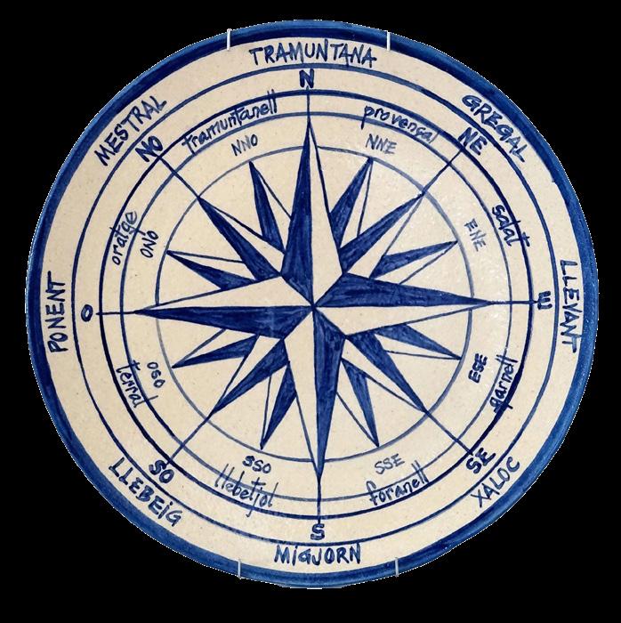
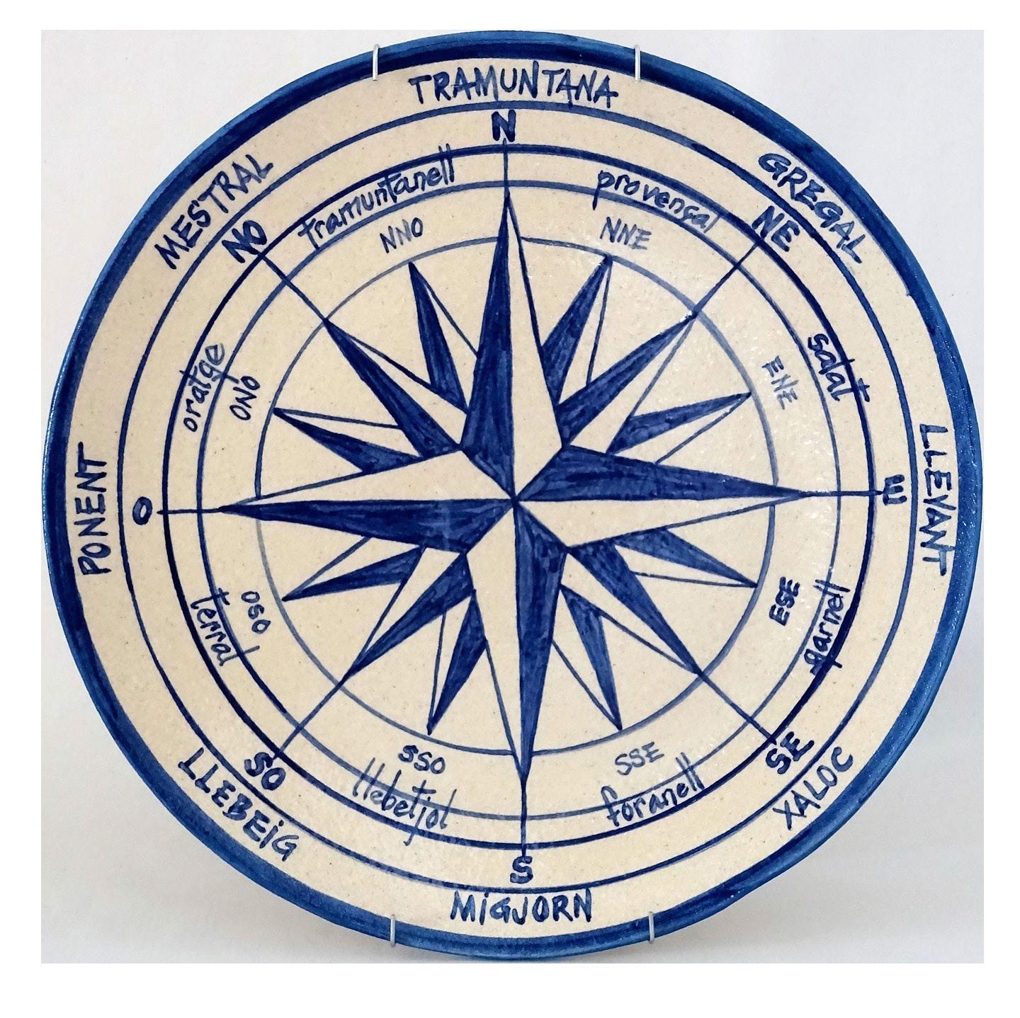
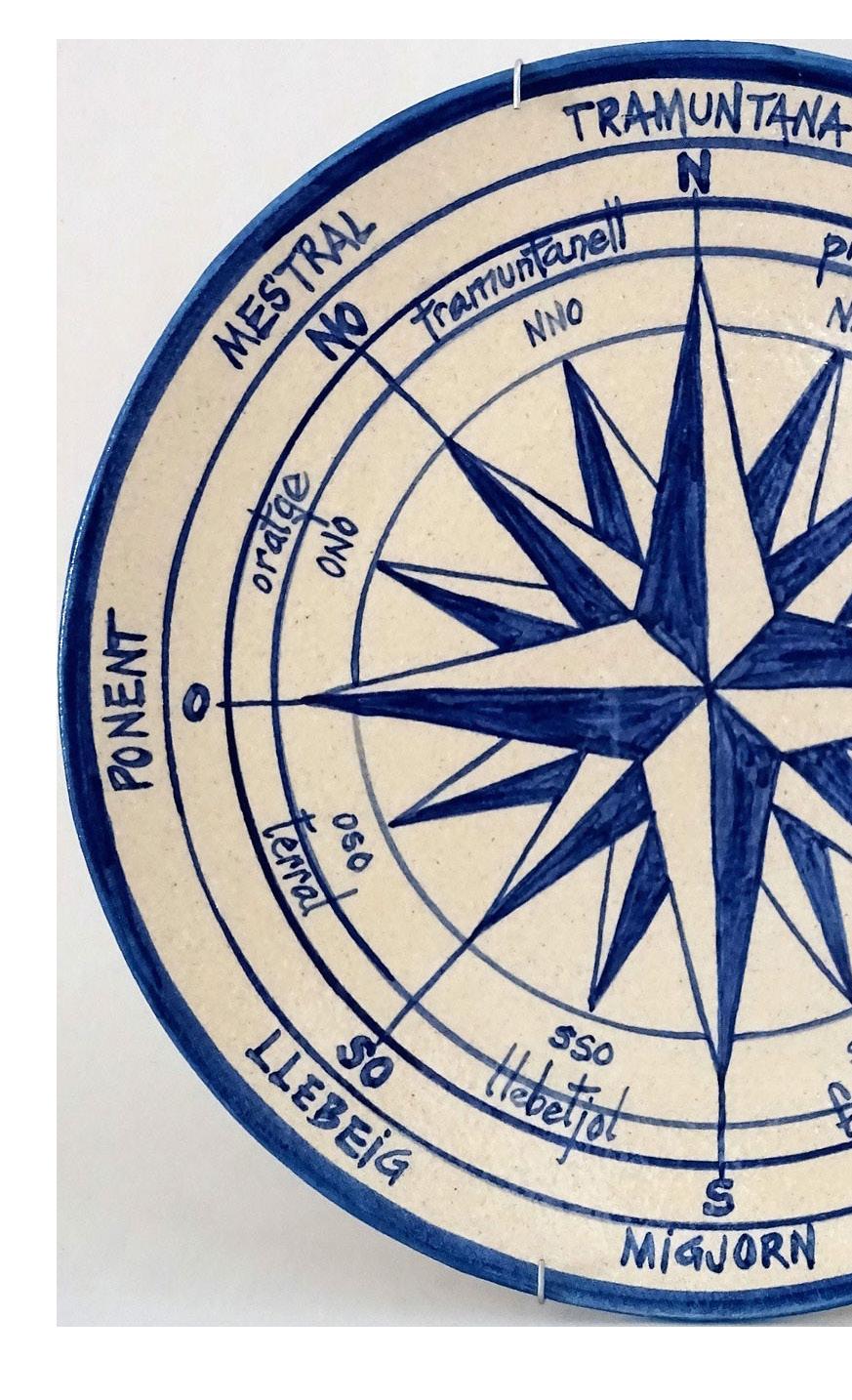
The Mediterranean Wind Rose
In the Mediterranean, eight out of the thirty-two winds have been given specific names according to their origin. This makes the “compass” for them simpler, more familiar, and somewhat less technical.
Mistral (NW-315º)
Because is situated on the island of Crete, in that direction lies the city of Rome, the “Magistral Pentium” (“Sovereign of peoples”). It is a hard, cold, dry wind that predominantly blows in winter.
Mediodía (S-180º)
Also known as Austro or mitjorn (noon), referring to the south, where the sun reaches its highest elevation at midday. It is a dry and warm summer wind caused by southern winds arriving straight from the Sahara.
Sirocco (SE-135ª)
Derived from “syriacus,” the name given to the southeast wind of the Roman “Wind Rose,” centered on the southern coast of Crete, pointing towards Syria. It is a dry and warm wind attracted by low pressure in the Mediterranean.
Tramontana (N-0º/360º)
From the Latin “transmontano,” meaning “beyond the mountains,” originating beyond the mountainous areas such as the Pyrenees. In Spain, it affects the northern shore of the Mediterranean basin, bringing Atlantic storms to the Gulfs of León or Genoa via southern France or northern Spain.
Poniente (W-270º)
Named after the cardinal point where the sun sets, these rainy winds drive Atlantic storms to the Iberian Peninsula.
Lebeche (SW-225º)
Anticipated by the appearance of calima (warm fog) on the southern horizon, this wind often brings sand and dust after passing through the Sahara desert.
Gregal (NE-45º)
Centered on the southern coast of Crete, northeast of which lies Greece. The term gregal reflects this northeast direction.
Levante (E-90º)
The cardinal point where the sun rises due to Earth’s rotation. This wind blows at varying speeds, sometimes causing simple shears and other times generating violent and destructive storms
CARTAGENA DE INDIAS and the sea
CARTAGENA
Geographic position
The geographic coordinates of Cartagena de Indias are located at the highest point of its geography, which covers 83.2 km2. From there, there is a perfect panoramic view of the city and its island area. This point is atop the now-called “Stern Hill/Cerro de La Popa,” initially named “Galley Hill/Cerro de la Galera” by the Spanish in 1510
because it resembled a large galley ship protruding from the sea. The summit was named “The Stern galley/La Popa de la Galera,” now simply known as “The Stern/La Popa.” The coordinates are: 10°, 25’, 18’’ N; 75°, 31’, 32’’ W, where the cistern of the Augustinian Recollects convent has been located since 1611.
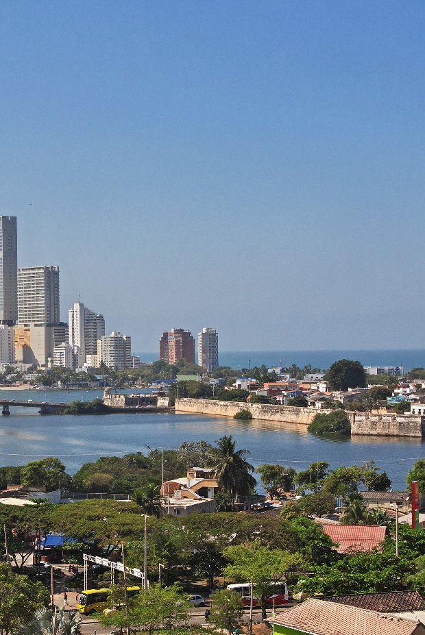
The Wind Rose and Cartagena Bay During Colonial Times
The concept of the Wind Rose expanded with the arrival of nautical expeditions, using prevailing winds as reference points. Another application was plotting the courses for approaching and entering ports, now referred to as navigation channels.
Cartagena’s Port
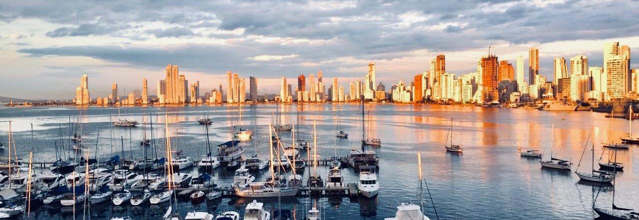
Founded in 1533 by the Spanish, Cartagena de Indias quickly became a prosperous commercial port. It was renowned as the ‘Queen of the Indies’. In 1544, the city was plundered by pirates. By the early 17th century, it was the second most important commercial hub among all Spanish-colonized territories, after Mexico City. Nationalist revolutionaries led by Simón Bolívar, known as the Liberator, seized the city from the Spanish in 1815, lost it later that same year, and regained control in 1821.
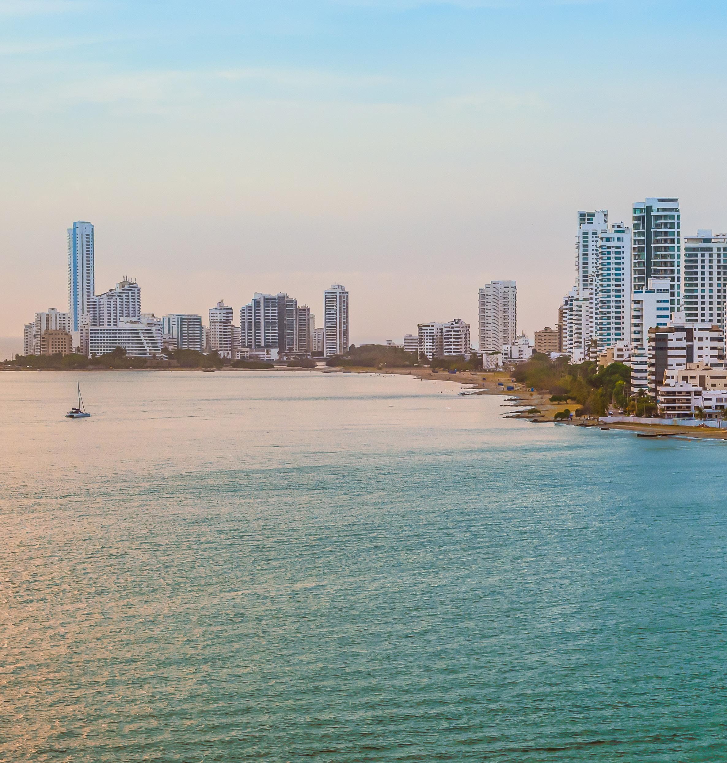
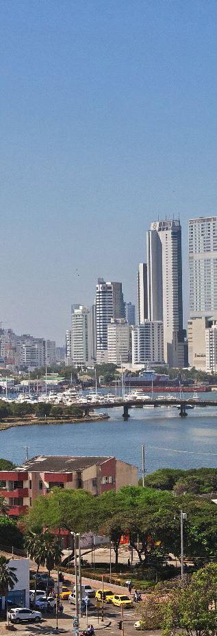
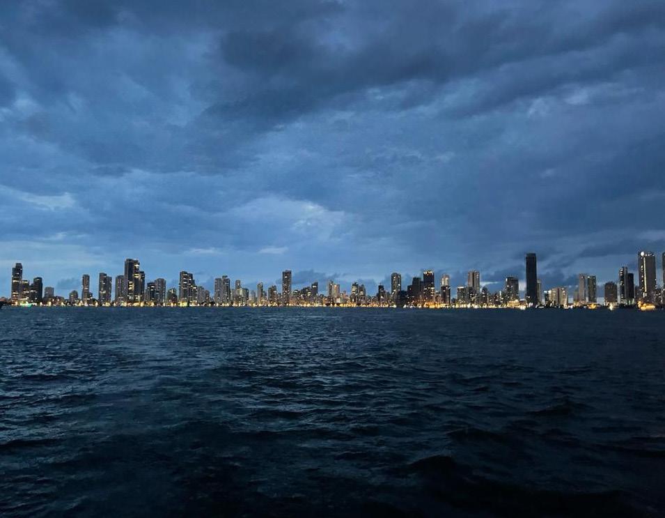
Cartagena de Indias is a city in northern Colombia, serving as the capital of the Bolívar department and a port on the Caribbean Sea. The city is located on a
small, shallow island in the bay, one of the finest in northern South America. It is connected to the mainland by a raised road. The old part of the city features two historic forts and is surrounded by a wall, some parts of which are 12 meters wide, built during the Spanish colonial era. Among the notable buildings in the city are the cathedral, the Jesuit church of San Juan de Dios, and the palace that once housed the headquarters of the Spanish Inquisition in South America.
Here is also situated the University of Cartagena (founded in 1827), and the city serves as the terminal point of an old oil pipeline that extends about 600 km inland into Colombia. Its port, fortresses,
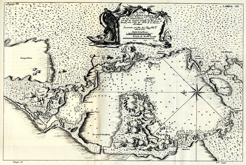
Cartagena de Indias Bay Nautical Chart -1735
and monuments led to its designation as a UNESCO World Heritage Site in 1984. The main export products include oil, petroleum, and coffee, with tobacco, livestock, wood, and gemstones also being exported. Notable local products
include chocolate and candles. Starting in the early 1990s, tourism gained increasing importance in the city’s economy.
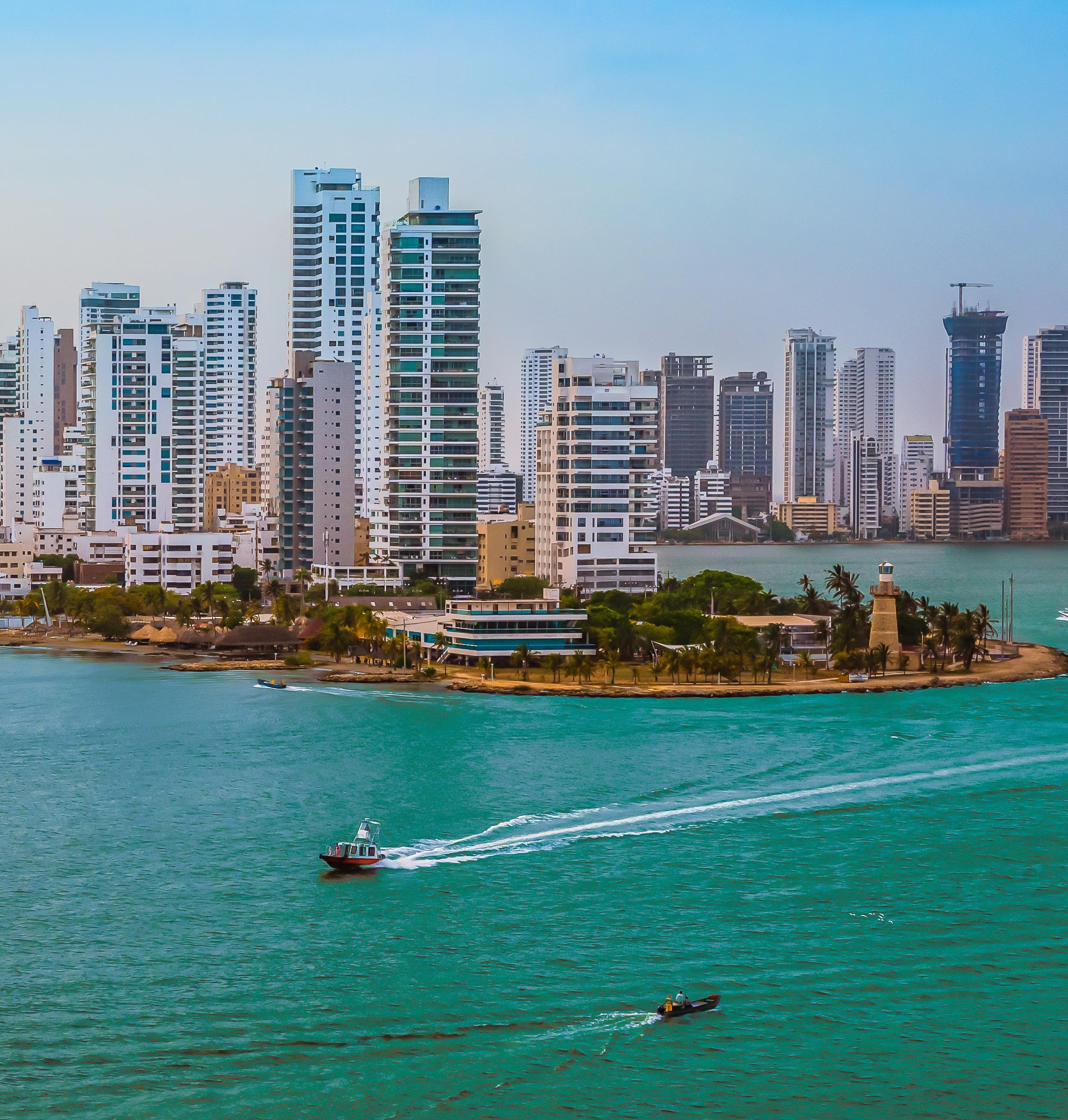
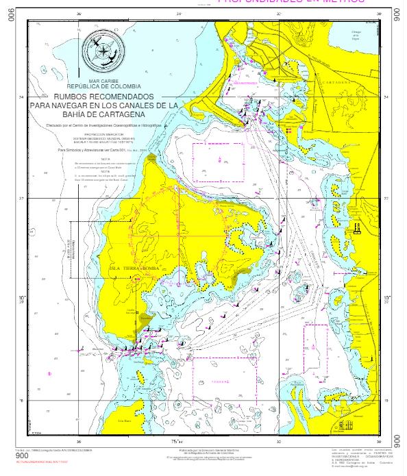
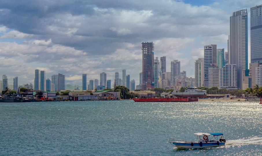
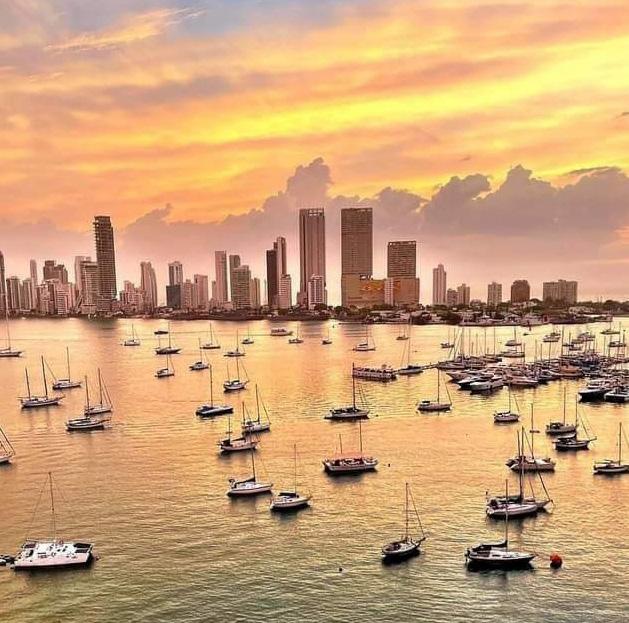
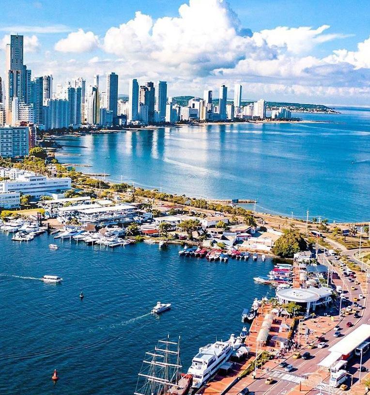
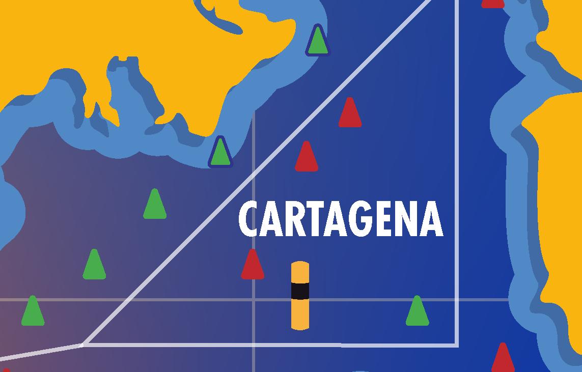
Its bay is the largest on the North Coast of Colombia, stretching 9 miles in length and averaging 4 miles in width, providing excellent shelter for vessels. The points of Castillo Grande and Manzanillo divide the bay into inner and outer sections, with numerous navigation aids present. The entrance to the bay, known as Bocachica, lies between the islands of Barú and Tierra Bomba, with a permissible draft of 14 meters (45.9 feet). For navigation through this area, the following considerations should be taken into account:
1. Main Channel: Recommended for vessels with a maximum draft of 10.2 meters without restrictions. Vessels with drafts up to 11 meters can navigate under the following conditions:
- Navigation should be assisted by tugboats.
- Use the center channel towards the green buoys, particularly towards the side where San Fernando Fort is located, both when entering and exiting the bay.
2. Colonial Channel: Allows for a maximum draft of 14 meters. Special caution is necessary at the turning points to enter and exit the Colonial Channel, especially near buoy No. 6 where there is a critical depth of 11.1 meters.
These guidelines ensure safe navigation within Cartagena’s bay, leveraging its strategic layout and historical fortifications to guide maritime traffic effectively.
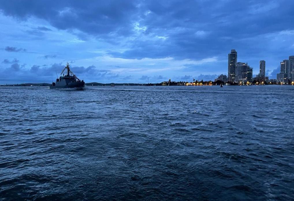
Due to its geographical position, Cartagena serves as a crossroads for many of the major maritime routes, particularly due to its proximity to the Panama Canal and most ports in the Caribbean and the Gulf of Mexico area. In Cartagena, there is a large industrial and commercial complex, alongside being a highly attractive tourist destination. The climate is tropical, with an average temperature of 27 degrees Celsius and moderate rainfall throughout the year.
Cartagena de Indias and The Sea | 15
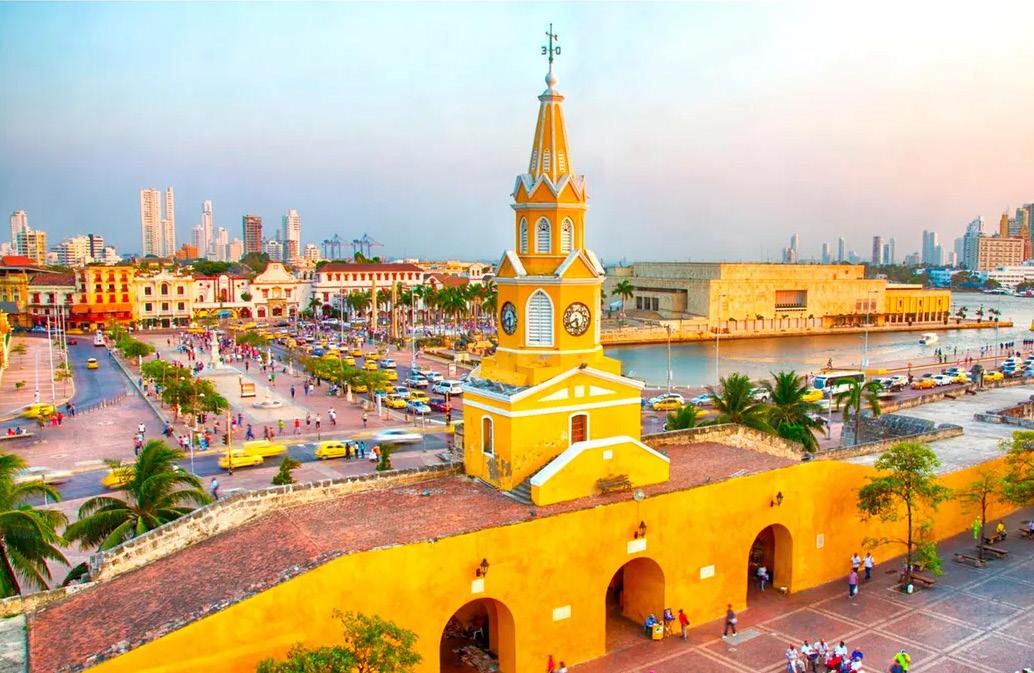
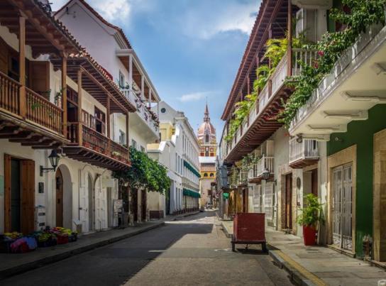
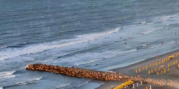
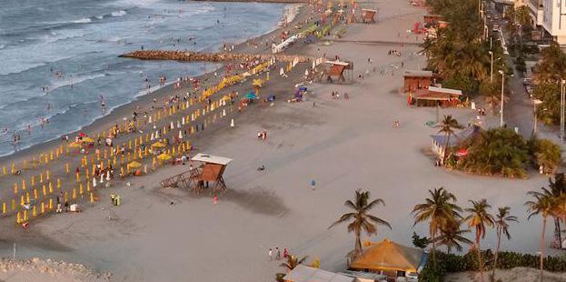
The old city of Cartagena is one of the few urban centers in the world that remains completely surrounded by walls. This walled enclosure is one of the city’s top tourist attractions, not only for its military engineering but also for the beautiful civil and religious architecture found within. Cartagena de Indias is predominantly a tourist city, well-equipped with infrastructure to meet all needs in this regard. It boasts expansive and beautiful beaches within the city and on its islands like Barú and the Co-
rales del Rosario archipelago, as well as numerous restaurants and a large hotel capacity.
In addition to its natural beauty, Cartagena offers cultural attractions such as museums like the Gold Museum and the Caribbean Naval Museum. It is home to historical sites such as The Stern Hill, San Felipe de Barajas Castle, and the Inquisition Palace, among others. The city also features several churches of significant artistic and colonial value.
CARTAGENA de Indias WIND
CARTAGENA Indias WIND ROSE
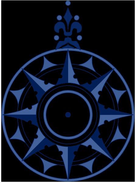
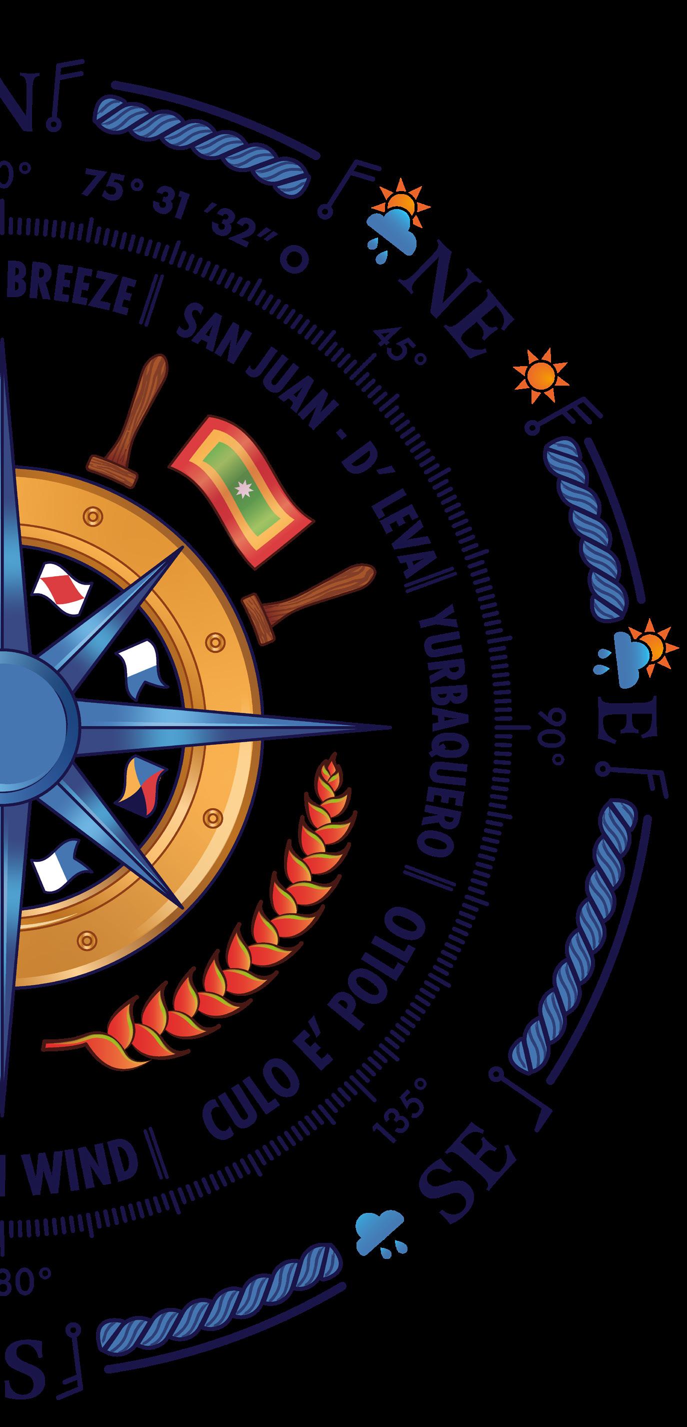
Cartagena’s Wind Rose Illustration
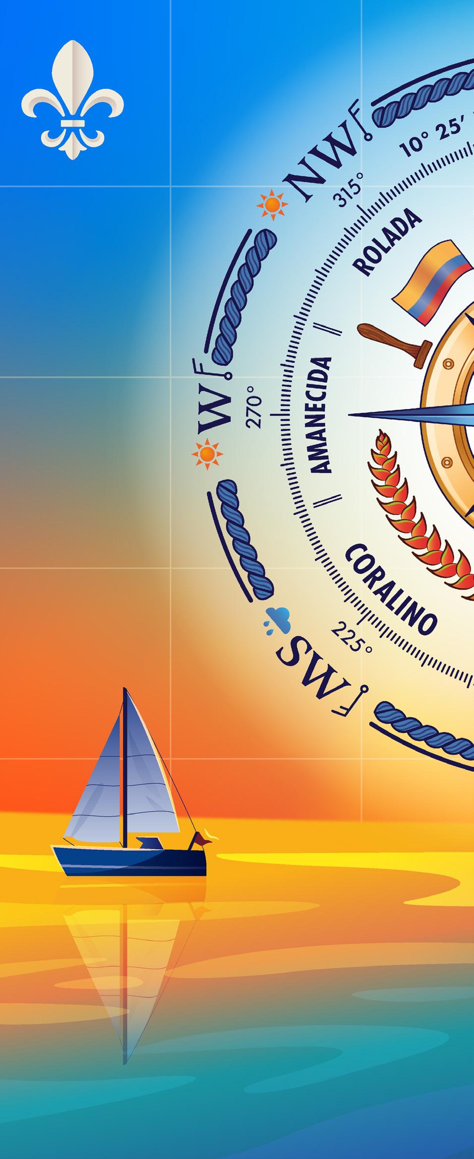
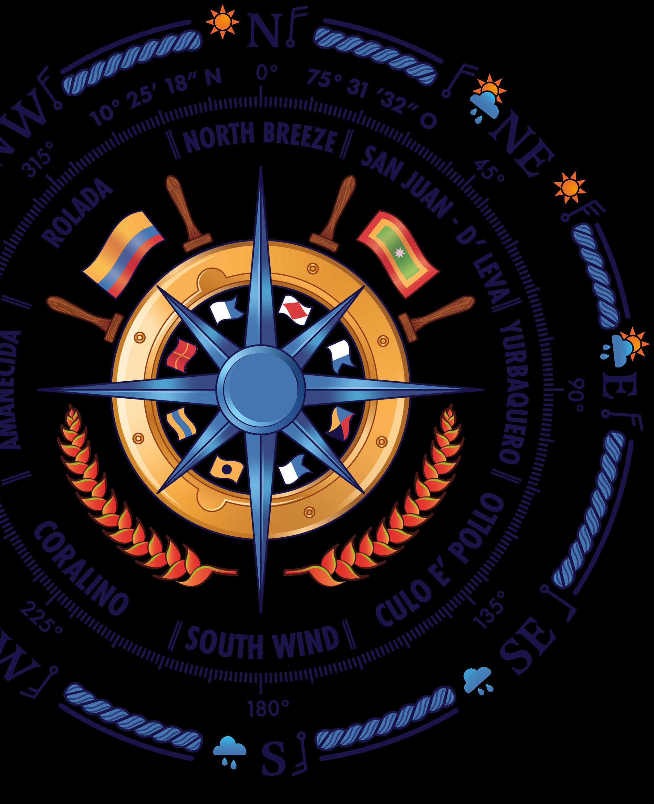
The Cartagena de Indias Wind Rose illustration, is composed of five circles that present their information from the outermost to the innermost as follows:
On the outer circumference, No. 1, we find acronyms and symbols separated by a blue marine rope. These acronyms represent the directions of the cardinal points and their 45-degree divisions, forming a total of eight directions on the circumference as follows: North with the letter N; South with the letter S; East with the letter E; and West with the letter W. Northeast is represented by the letters NE; Southeast by SE; Southwest by SW; and Northwest by NW. The letters W, NW, N, NE, and E are arranged to be read from left to right in a clockwise direction.
To the left of each acronym, a sun or a cloud represents the season during which prevailing winds blow in each direction. The orange sun symbolizes the summer season, while the blue cloud symbolizes the winter season. On the right side of the abbreviations, the strength and direction of the wind are indicated using symbols from the Beaufort scale as follows: N-force 5, NE-force 5 and force 6, E-force 5, SE-force 11, S-force 3, SW-force 4, W-force 5, and NW-force 5. Additionally, in the NE direction, towards the N and E, there is a cloud with a sun above it, indicating a transitional period between summer and winter when these winds occur.
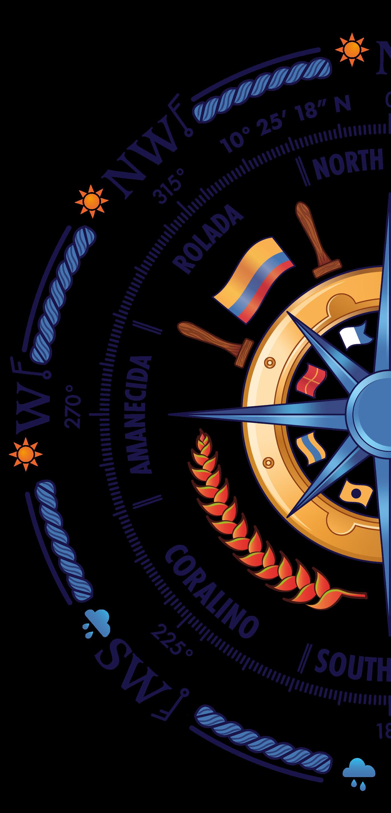
In the next circle, No. 2, we observe the image of a compass with small, evenly spaced, navy blue dotted lines marking the degrees of the cardinal points and their 45-degree divisions as follows: 0°, 45°, 90°, 135°, 180°, 225°, 270°, and 315°.
Above the compass, on either side of 0°, are the coordinates of Cartagena de Indias’ geographical location. Inside the compass, the names of the prevailing winds in each direction are marked as follows: 0° North Breeze, 45° San Juan – De Leva, 90° Yurbaquero, 135° Culo e Pollo, 180° South Wind, 225° Coralino, 270° Amanecida, and 315° Rolada.
Next, the circumference No. 3 is divided into two equal parts transversally. In the lower part, there are two stands of red and green heliconias facing upwards, positioned on either side of the tip of a star pointing south. In the upper part, there are four wooden handles of a ship’s wheel, with the flag of Cartagena de Indias on the right and the flag of Colombia on the left between them.
In the penultimate circle, No. 4, there is a golden hatch with six screws and two hinges reflecting the sunlight.
The last circle, No. 5, consists of a string of nautical flags representing the letters Romeo, Alfa, Fox, Delta, India, and Zulu. These flags are separated by the points of a star. In addition to decorating, the flags form a hidden message that spells out the name of the author of the Cartagena de Indias Wind Rose. To read the message, you need to divide the circle transversally and then read from left to right, first the top half and then the bottom half.
Finally, the innermost layer of the Cartagena de Indias Wind Rose, features a metallic royal blue star with eight points, a universal symbol of the compass rose.
Prevailing Winds: Characteristics and Cultural Stories
Cartagena de Indias Wind Rose
NORTH BREEZE SAN JUAN BREEZE
Range Direction
WNW-ENE
Prevailing Speed & Direction
F4-F5 13-21 Knots- Moderate breeze to fresh breeze
Season
Summer (Dec-Apr)
It is a constant and persistent breeze, bringing with it a dark soot that clings to everything and spreads dryness over the land. During colonial times, this breeze was utilized by canoes carrying goods to the mouth of the Atrato River in the Urabá Gulf and the San Blas Archipelago in Panama. Similarly, in the face of pirate and privateer sieges on the city, it was also called the “Defender Breeze” because it hampered the maneuvers of navigators attempting to plunder Cartagena.
Range Direction
N-NE
Prevailing Speed & Direction
F4-F5 13-21 Knots- Moderate breeze to fresh breeze
Season
“Transition” from Summer to Winter (May-July). Tipically occurs in June and July. It marks the start of hurricane season. (June-November). August and October are the most intense months.
It is named for appearing during the so-called “St. John little summer,” which is a period with atypical conditions for a winter season, such as high temperatures and strong breezes for short periods. This is why it is called “Little summer”. The name “Saint John” comes from its occurrence around June 24, the date celebrating the birth of Saint John the Baptist, a European celebration that spread to the Americas over 300 years ago.
The local sailors eagerly anticipate the St. John breeze as their last chance, after the end of the summer season, to hoist their sails and set off to enjoy the wind, the sea foam, and the heeling of their sailboats along the coasts of Cartagena.
DE LEVA BREEZE
Range Direction
N - NE
Prevailing Speed & Direction
F5-F6 22-27 Knots- Fresh breeze to Strong breeze
Season
Summer (Dec-Abr). Tipically occurs in January and February
It originates from the intrusion of polar fronts from the Northern Hemisphere (low-pressure systems) into the Caribbean Sea. When these fronts reach 15 degrees latitude (about 150 nautical miles north of La Guajira), they push the waters toward the coast, causing an abnormal increase in wave height and strength, known as the “De Leva Sea”. The phenomenon lasts approximately 48 hours, with its beginning being more intense than its end. However, its strength is amplified by the Trade Winds, which during this period blow from the North-Northeast and are more intense in the afternoon, making the phenomenon particularly hazardous during those hours. Navigation for smaller vessels is restricted when these breezes occur to prevent collisions.
Cartagena de Indias Wind Rose | 21
YURBAQUERO WIND
Range Direction
E-SE
Prevailing Speed & Direction
F3-F4 7-15 Knots- Gentle wind to Moderate wind E
Season
Transition and Winter
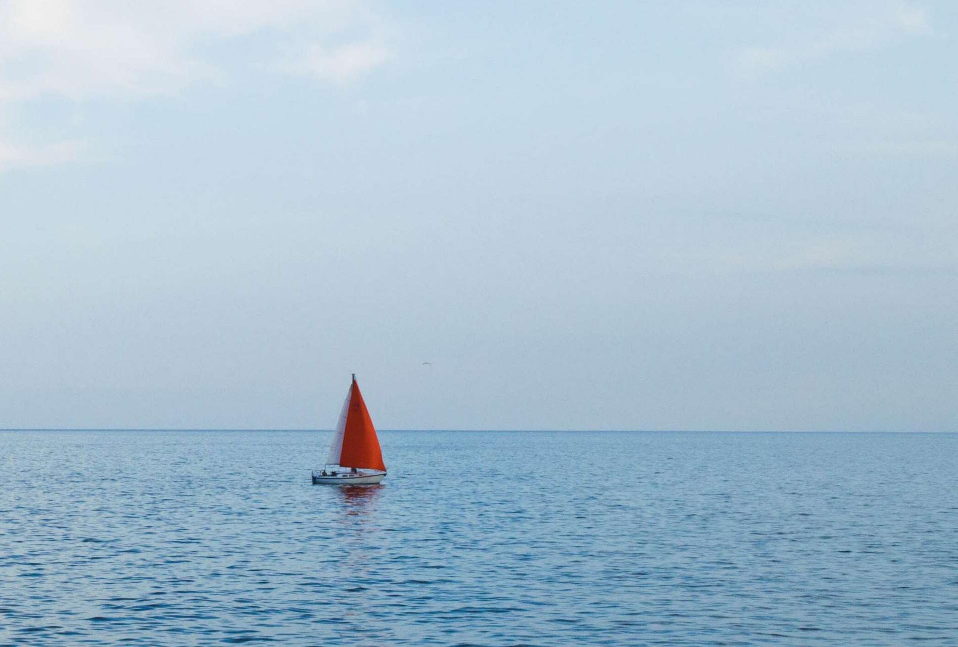
It is a gentle, cool wind coming from a picturesque hilltop at 200 meters above sea level, surrounded by lush vegetation, with an average temperature of 27 degrees. This area was historically home to the Yurbaco tribe, known as “Turbaco,” and further south, Turbana, at 80 meters above sea level. Colonial Cartagena relied on the breeze and wind to supply itself with goods produced in the agricultural lands of Turbaco and Turbana. From Pasacaballos, canoes would set out in the early morning, utilizing the East and Southeast winds, loaded with goods for the Bay of the Spirits (the main maritime entry since Spanish colonial times). In the afternoon, they would return to Pasacaballos with the North or Northwest breeze, repeating the cycle. Today, this wind, with its pleasant temperature due to its elevation, invites sailors to navigate the Bay of Cartagena and enjoy the sunset, one of the city’s most beautiful natural spectacles.
CULO E POLLO WIND SOUTH WIND
Range Direction
S -SE
Prevailing Speed & Direction
F9-F10 41-55 Knots- Strong/severe gale to Storm, SE
Range Direction
WSW-ESE
Prevailing Speed & Direction
F3-F4 7-15 Knots- Gentle wind to moderate wind, S
Season Season
Winter (Aug-Nov)
It is a type of small waterspout that moves relatively slowly but with very strong winds. It is heralded by a period of stifling heat and a sudden dead calm (Dead calm, meaning complete absence of wind), followed by a noticeable drop in temperature. From that moment, there are approximately 7 minutes to prepare: lowering sails, closing hatches, and securing everything. It lasts on average 10 minutes, though it feels much longer due to the intense wind and rain. This weather phenomenon appears to be generated by low-pressure systems caused by the evaporation of waters from the wetlands in southern Bolívar, which move northward with the direction of winter winds.
The natives of Bocachica colloquially referred to it as “Culo e’ Pollo” in a playful manner because they struggled to pronounce “Carbón Disclosure Project,” the meaning of the British organization’s initials, CDP, that was present in Cartagena in the 1950s. During that time, a team of scientists was attempting to develop detection measures for the phenomenon to establish an alert for sailors, but they never succeeded. The coincidence of the company’s initials with the description of the weather phenomenon, along with the sense of fear (“culillo”) it generates upon arrival, led to the unique name for this wind.
Winter (Aug-Nov)
It is a playful, gentle, and capricious wind, although at times it can become stronger than the breeze and often comes in the form of rain that washes and refreshes the environment. During colonial times, canoes took advantage of this wind to transport bananas, wood, and coconuts to supply the city. Due to the challenges of sailing on long voyages, it was also called the “Saving Wind” for its role in facilitating the arrival of sailors to Cartagena.
CORALINO WIND
Range Direction
S-SW
Prevailing Speed & Direction
F3-F4 7-15 Knots- Gentle wind to moderate wind, SO
Season
Winter (Aug-Nov)
It is a soft and refreshing breeze that originates from an archipelago of 27 islands located to the southwest of Cartagena de Indias, known as the “Corales del Rosario.” This archipelago invites visitors to enjoy its white sandy beaches and crystal-clear waters in shades of blue and green, providing a perfect place to relax and rejuvenate the spirit. The Corales del Rosario is situated 20 nautical miles southwest of Cartagena, and along with the San Bernardo Archipelago, located 22 nautical miles further south, they form Colombia’s Natural National Park. This park features the largest coral platform in the continental Caribbean of Colombia (about 420 km²), making it a favorite destination for sailors in Colombia.
Cartagena de Indias Wind Rose | 23
AMANECIDA BREEZE
ROLADA BREEZE
Range Direction Range Direction
NW-N W-NW
Prevailing Speed & Direction
F3-F4 7-15 Knots- Gentle breeze to Moderate breeze, O
Prevailing Speed & Direction
F3-F4 7-15 Knots- Gentle breeze to Moderate breeze, NW
Season Season
Summer (Dec-Apr)
It is a breeze that starts with the sunrise blowing “True” from the West during the day with a low temperature. (“True” wind is one that blows strictly from a particular direction, without deviating even slightly.) This direction is preferred by sailors when they want to circumnavigate Tierra Bomba Island. If the breeze is constant and strong, it allows for sailing on a beam reach (wind coming from the side), increasing speed and performance both outside and inside the island. When this morning breeze persists for several days, it is called a “Brisón.” Yesteryar sailors, lovers of Cartagena’s history, referred to it as the “Heroic Breeze” when they experienced its onslaught on the old city, accompanied by strong waves crashing against the walls like cannon fire from galleons. These walls have stood for approximately 500 years, recalling the resistance of the people of Cartagena during the 105-day siege of Morillo in 1805, which earned the city its title of “Heroic City.”
Summer (Dec-Apr)
It is a morning breeze that gets its name because it gradually shifts, or “rolls,” toward to North until it becomes a true North wind (“True”) between 12 PM and 1 PM. It continues in this manner throughout the day and then dies off, rolling again and ending as a true West wind (“Franca”) between 11 PM and 12 AM.
(“True” wind is one that blows strictly from a particular direction, without deviating even slightly.)
Illustration
“The Rose Twilight”
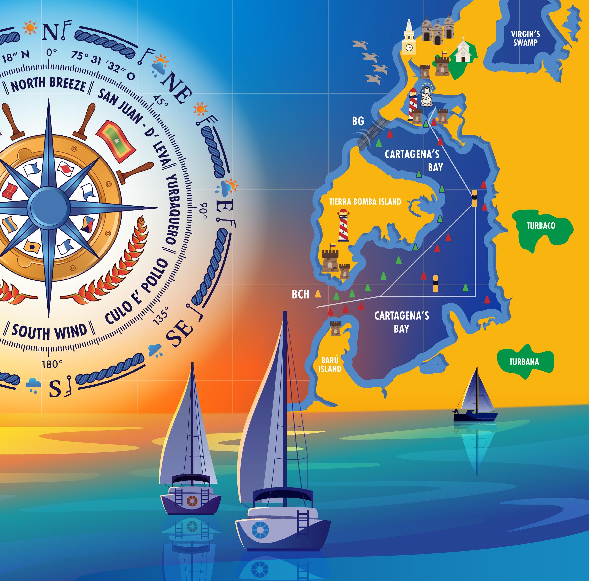
“The Rose Twilight” is a graphic composition featuring two illustrations that blend, complement, and adorn each other to form a single artwork. This piece has a background that can be interpreted as either the sky or the sea, depending on how you prefer to appreciate the composition. It can also be appreciated from different perspectives—whether from above, from the front, or even from the side— using a bit of imagination.
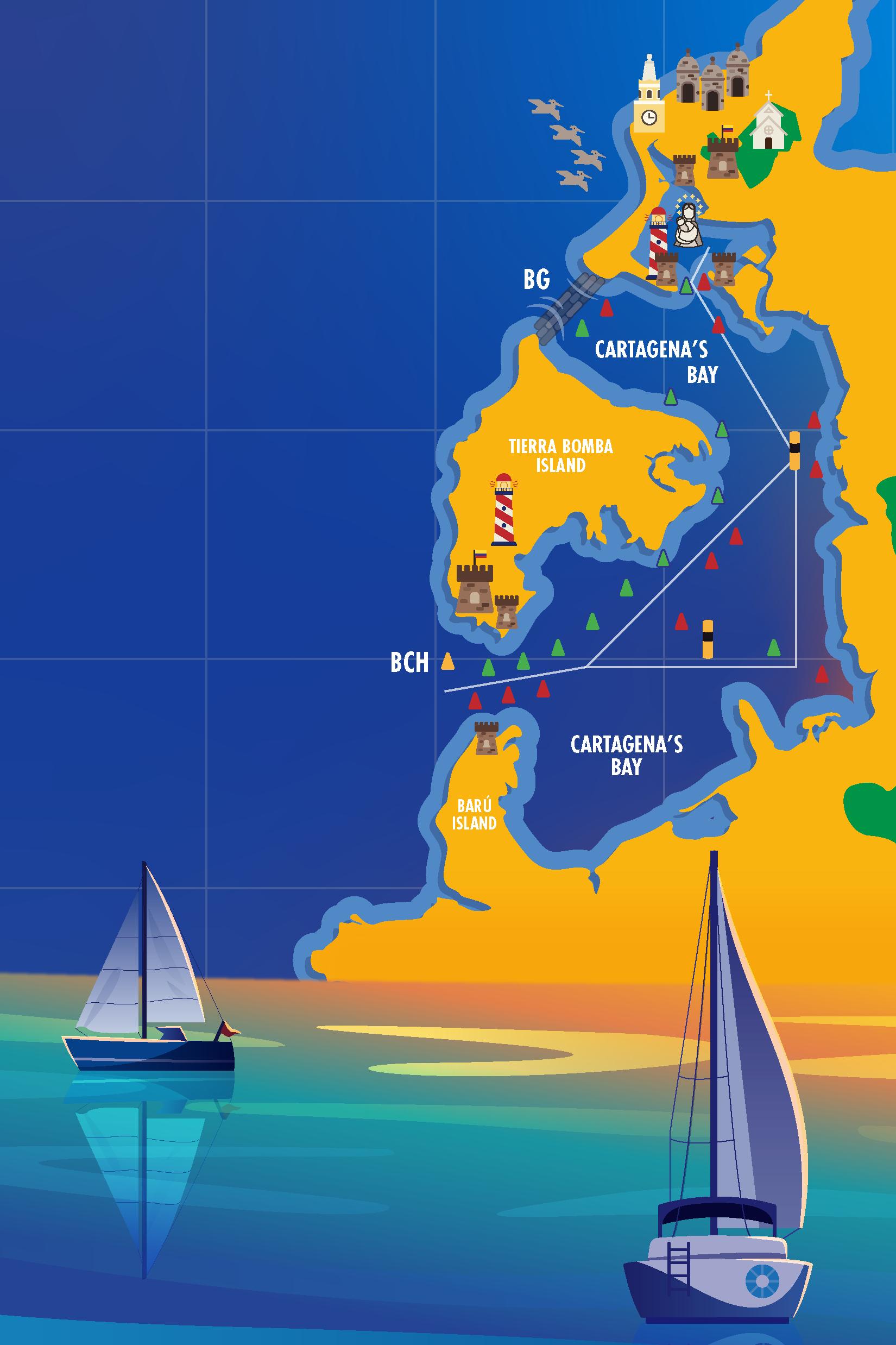
The first illustration is a nautical chart of Cartagena de Indias, displaying its graticule lines (latitude and longitude), its inner and outer bays, and the nearest island areas such as the islands of Manga, Manzanillo, Tierra Bomba, and the northern part of Barú. It also highlights the access points to the bay, the maritime access channel marked by red and green buoys starting from the entrance at Bocachica, and the yellow and black clearance buoys, North and South, of Santa Cruz sand
bank. Additionally, it details the coastal geography and the lighthouses of Tierra Bomba and Castillogrande. Finally, to the west of Cartagena, over the sea, the illustration features the Cartagena de Indias Wind Rose with the fleur-de-lis indicating the North, and to the east, the city’s geography is depicted.
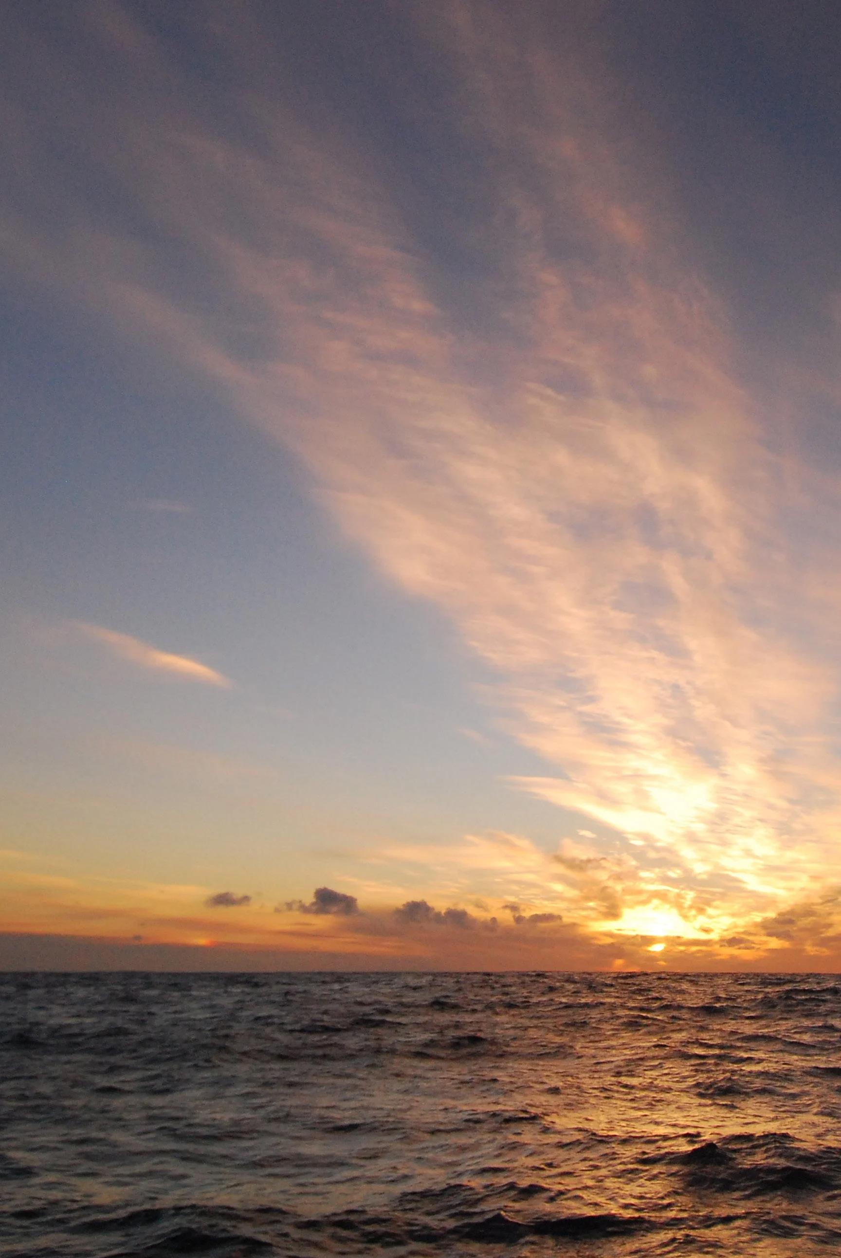
The second illustration depicts a seascape and a historic nautical channel where the Cartagena de Indias Wind Rose captures all attention, becoming the centerpiece of a beautiful sunset. As the sun, with its radiant aura, spreads its light over
the sea, its reflection adorns the scene with sailboats heading toward the horizon while simultaneously they approach to Bocachica. With a steady south wind, two sailboats have their sails set in a position known as “donkey ears” to make the most of the wind, while the other two navigate in opposite directions, seeking to improve their approach to the bay.
As a nautical corridor, the illustration highlights symbols and historical details of Cartagena can be appreciated while sailing from the entrance at Bocachica to inner bay. Among these are the colonial
Spanish military forts located along the inner and outer bays, and the entrance of “Las Animas” bay to defend San Felipe Castle; Pasacaballos and Turbana, crucial for supplying provisions to Cartagena; the lighthouses serving as navigation guides; Boca Grande seawall, a barrier constructed to obstruct the passage of ships; the Clock Tower, the gateway to the old city; the old city, or “Corralito de Piedra”; La Popa Hill and its monastery; the Carmen virgin in the inner bay, the sailors patroness; and along the coast, near Las Tenazas, pelicans offering their customary aerial show.
Elements of “The Rose Twilight”
Illustration
cis Drake, compelled the Spanish Crown to design a serious fortification project to make Cartagena de Indias the most fortified city in the Americas.
THE OLD CITY
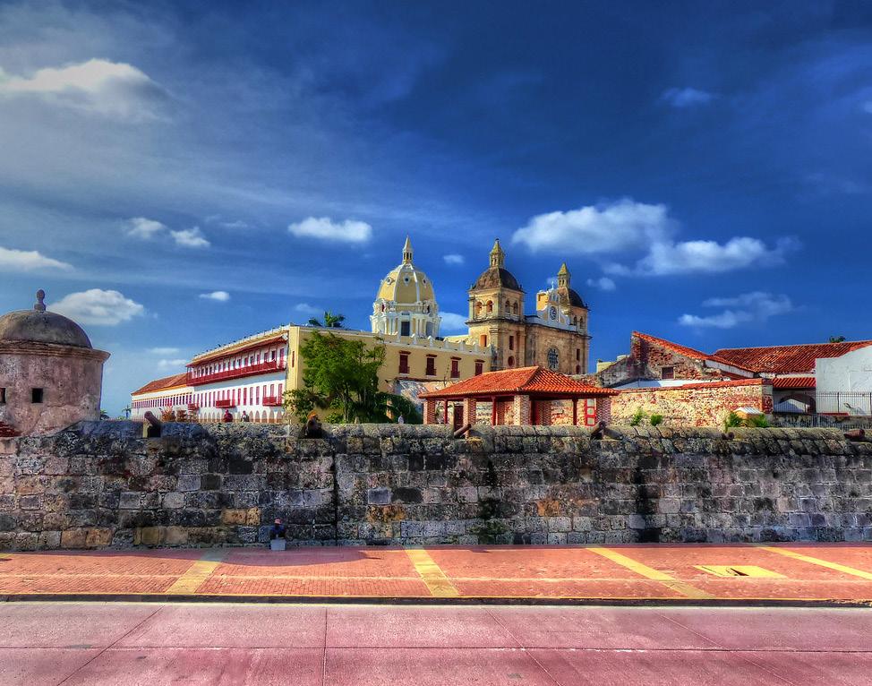
The old city with Getsemaní, San Diego, and La Matuna, are the oldest part of Cartagena, featuring a historic walled cordon with bastions that measures approximately 11 kilometers. This is one of the most significant elements of Cartagena’s cultural heritage. Initially, there were 22 bullwarks in Cartagena’s fortification system. Expand public roads and create a public market were the main reasons for the demolition of some of them. Today, 17 remain.
Invasions by the English and French, such as those by Martin Cote and Fran-
The walled city is the historic center of Cartagena de Indias and has been declared both a national heritage site of Colombia and a UNESCO World Heritage site. During the colonial era, it was home to nobles and important figures. Today, it is a hub of hotels, restaurants, museums, and commerce, including jewelry stores and artisan shops, as well as nightclubs, bars, and pubs.
BULLWARK
Pentagonal structures that protrude at the union angle between two parts of a wall.
BOOTH
Small tower with loopholes built at the most prominent angle of the bulwark, which serves as shelter and protection for the sentinels.
It’s an emblematic 30 meters high clock construction that rises between Los Coches and La Paz squares. Built over a wall, it is considered one of the five most beautiful public clocks in the world. Its first structure was laid in 1601, and called “The bridge door”. When the walled enclosure the city was completed in 1631, it became the main gate of the city then called Calamari. The first clock displayed was brought from the United States in 1874, 63 years later, was imported the current clock from Switzerland.
CLOCK TOWER
THE STERN HILL/ STERN MONASTERY
When the Spanish discovered it from the sea, they named it The Galley Hill, and its summit, The Stern Galley. Legend says that Fray Alonso de la Cruz Paredes, Augustinian, had a virgin vision while he was in full meditation. She asked him to build a church on the hill to put end to the tributes that were offered to the evil spirit that lived there.
In 1815 it was the scene of the Pablo Morillo’s troops assault and the augustinians had to abandon the convent which caused its deterioration. Years later it would be inhabited again, but this time as a barracks, with one of its most famous guests being Simón Bolívar. In 1961, the Augustinians returned to the Convent. Currently it is one of the most visited tourist attractions in Cartagena de Indias.
de Indias Wind Rose |
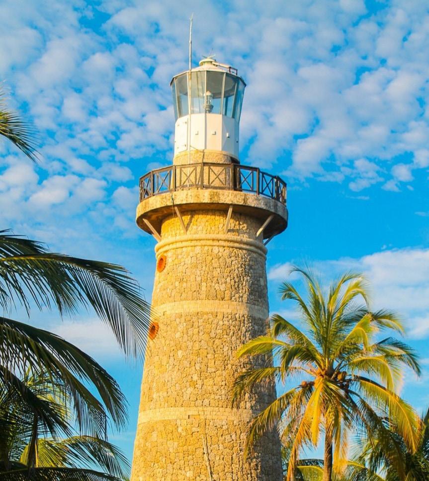
TIERRABOMBA LIGHTHOUSE
It is located in the highest part of the Tierra Bomba island. It is a red tower with white bands. It is 112 meters height and has a 26 nautical miles range.
CASTILLOGRANE LIGHTHOUSE
Located in the traditional Cartagena Navy Officers Club at the end of the Castillogrande neighborhood, where the Santa Cruz fort was formerly located and also is in front of the illustrious guest house, where the San Juan de Manzanillo fort was formerly located at the western end of the Manzanillo island. This lighthouse marks the entrance of boats to the inner Bay of Cartagena. Its design was inspired by sea snails and is a tribute to the city’s military architecture. It is a beige concrete tower, is 24 meters height and has 12 nautical miles range.
DEL CARMEN VIRGIN
A colossal sculpture of Carmen Virgyn, also known as the Sea Virgin and the sailors patroness. Erected on July 16, 1958. It is located in a short distance north from the midpoint between the tip of Castillogrande and the tip of Manzanillo Island in the inner bay on a sand bank that has borne its name for 40 years, Entering the bay, the Virgin’s sand bank bifurcates the navigable channel to the right into the commercial channel and to the left into the military channel. The statue stands 15 meters tall and is made of nearly 20 tons of Italian white marble, with a 4-meter-tall child in her arms.
Cartagena
SANTA CRUZ OR CASTILLOGRANDE FORT
At the beginning of the 17th century, it was decided to fortify the inner bay, and in a Royal Decree of 1608 was ordered the construction of a fort at Punta del Judío, known as Santa Cruz, popularly known as Castillogrande.
The fort’s defensive strategy shifted to focus on the Bocachica entrance when the Bocagrande passage was closed in 1640. Castillogrande survived until the French attack led by Baron De Pointis in 1697, which left it seriously damaged. It was rebuilt in 1728, but when Vernon attacked the city in 1741, it was partially destroyed and not rebuilt, with its remnants subsequently used as an artillery powder magazine. This use continued until 1938 when an explosion of an ammunition depot stored there destroyed its vaults, leaving only part of the curtain wall near the anchorage and other remnants. Today, it is part of the facilities of the Naval Officers Club of the National Navy.
SAN JUAN DE MANZANILLO FORT
At the beginning of the 17th century, the defensive strategy changed, favoring the fortification of the entrance to the inner bay instead of the Bocagrande passage. Governor Francisco de Murga promoted the construction of the Santa Cruz Fort at Punta Judío and the San Juan platform, erected around 1631 on Manzanillo Island. Santa Cruz, also known as Castillogrande, and San Juan prevented access to the anchorage through their crossfire. The munitions storehouse from this fort has been preserved and was restored by architect Germán Téllez around 1980, becoming part of the Illustrious Guests house of Colombia Government.
SAN SEBASTIAN DEL PASTELILLO FORT
This fort, located on Manga Island, stands where Cartagena’s first fort, known as El Boquerón, was situated. It was built between 1741 and 1744 by order of Viceroy Sebastián de Eslava and is named San Sebastián in honor of the viceroy. It is also called Pastelillo due to its distinctive “cake-like” shape. San Sebastián defended the entrance to the Bay of Las Ánimas and the access to the city by Manga Island. It has an irregular layout adapted to the terrain, surrounded by a crenelated wall, a guardhouse, a cistern, the Castellano’s house, a storehouse, and a dock. The fort was restored by architect Juan Manuel Zapatero in 1972 and is currently a restaurant managed by the Fishing Club.
SAN JOSE FORT
To complement the defense of the Bocachica passage, a fort-battery was added, which, together with San Fernando, made the enemy’s access to the outer bay impenetrable. San José is a reconstruction and reinforcement of the fort built by Juan de Herrera between 1714 and 1725, which was destroyed by Ver-
non in 1741. San José fell into neglect and ruin during the first half of the 20th century, but a proper restoration carried out in 1968 by engineer Juan Manuel Zapatero restored its original splendor. Today is used by the navy as the Cartagena de Indias maritime traffic station.
CARTAGENA’S ALCATRAZ
The “Alcatraz” we know in Cartagena is actually the Caribbean Brown Pelican, the most representative seabird of the city. It is recognized by its large, bare-skinned pouch under its beak, which can hold up to three times the capacity of its stomach. To fish, it dives into the sea from about 10 meters high and, after catching its prey in the pouch, allows the water to drain out before swallowing the fish. It is the only
animal that, through its throat, converts salt water into fresh water for its own consumption.
In Cartagena de Indias, the “Pelican-alcatraz” is part of local tradition, alongside the “mariamulata” and the “blue crab.” It is a spectacular sight to see them flying in flocks of 10 to 20 birds in a formation akin to an air squadron as they search for schools of fish and dive at speeds of up to 100 km/h to catch them. This can be observed at various points along Santander avenue. There is a monument dedicated to these birds which features the poem “El Alcatraz”, from of one of the most important figures of the 20th century in the city, Daniel Lemaitre Tono.
SAN FELIPE DE BARAJAS CASTLE
Cartagena was always a coveted target for pirates and enemies of the Spanish Crown, which is why the city’s defense against these threats was a priority for its inhabitants from the early decades of its existence. The San Felipe Castle is perhaps the most iconic monument of Cartagena de Indias. Built on a hill 130 feet high on a rise known as San Lázaro, it offered a panoramic view of Cartagena’s bay. Construction began in 1536 and was reinforced in 1576, transforming it into an impregnable fortress with 63 cannons, steep high walls that were nearly impossible to scale, and numerous tunnels, galleries, slopes, and mines designed to destroy the fort in the event that the enemy breached it. Throughout its long history of 500 years, the castle has been invaded by pirates, admirals, and barons, but it remains intact to this day. It was restored in 1928 and is visited by nearly all tourists who travel to the city.
SAN LUIS AND FERNANDO DE BOCACHICA FORTS
The San Luis de Bocachica Castle, was a military fortress located on Tierra Bomba Island, controlling the entrance to the Bocachica channel. Construction began in 1646. The castle played a key role in Cartagena’s defense but was captured by French forces in 1697 and by the English in 1741. On March 13, 1741, British troops landed in the city, destroying the castle under artillery fire and attacks from English ships.
In 1753, construction began on a new fortress, the San Fernando de Bocachica Fort, built over the ruins of San Luis de Bocachica Castle. The works were directed by engineer Antonio de Arévalo. Today, after a renovation carried out by the Society of Public Improvements, this fortress stands majestically at the entrance to Cartagena Bay.
BOCAGRANDE SEAWALL
Bocagrande was the widest access to Cartagena Bay. In 1640, it was completely blocked due to the grounding of a Portuguese ship on a sandbank, forming an isthmus that connected Tierra Bomba Island to the peninsula. A century later, the channel began to reopen due to tidal effects and work done to allow small vessels to pass, threatening to alter the bay’s entry point once again and rendering the fortifications built in the Bocachica channel ineffective. Attempts were made to close it in 1750 and 1754, but these efforts were unsuccessful.
Finally, on November 11, 1771, military engineer Antonio de Arévalo began constructing a seawall composed of three rows of stones, creating a sandy bed over which a stone crown was placed to prevent the passage of ships. The construction lasted seven years. Even today, the Bocagrande seawall withstands the sea’s forces and has kept the major entrance to Cartagena Bay closed since the late 18th century. There are 72.6 meters between the green and red buoys, and the depth ranges from 1.9 to 2.6 meters, considering the highest point of the seawall and sea level. The buoys are positioned about 30 meters inside the bay.
CARTAGENA BAY, MARITIME ACCESS CHANNEL, SANTA CRUZ AND VIRGYN SANDBANKS
The bay of Cartagena has two access points: 1. BG-Bocagrande: For vessels with a draft of less than 2.6 meters and 2. BCH-Bocachica: For larger vessels.
One mile from the entrance is located the sea buoy (where larger vessels arriving at the port meet the pilot). From there, navigate towards Bocachica, aiming the access channel, whose 118-meter wide entrance is located between the San José and San Fernando forts.
Navigation into the outer bay can be done through 2 wide and safe channels: through Brujas island channel or through commercial channel, between the green and red buoys. The yellow and black buoys (Cardinales) indicate avoid navigation of Santa Cruz and Virgin sandbanks. The inner bay can be entered through the commercial channel to the right of the south cardinal buoy of Virgin sandbank or to the left of the same cardinal buoy through the military channel.
TIERRA BOMBA ISL AND
CA RTAGENA’S
CA RTAGENA’S BAY
TURBACO
TURBANA BAY
BARÚ ISL AND
Cartagena de Indias Wind Rose
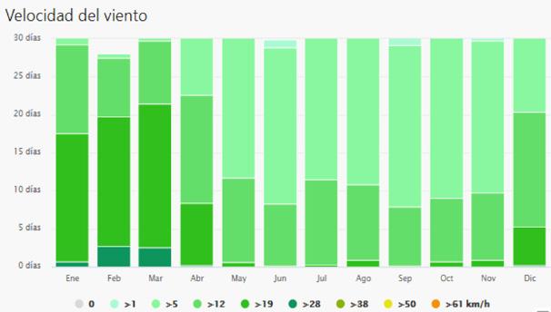
Cartagena’s Wind Force
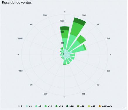
Cartagena’s Wind Direction by Day and Month by Hour and Year
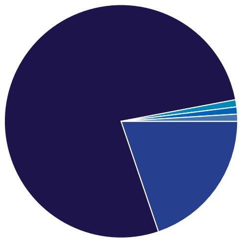
The following diagram shows the number of days per month during which the wind reaches a certain speed. As seen, the strongest and most consistent winds occur from December to April, while the calmest winds are from June to October.
This wind rose shows the number of hours per year that the wind blows from each indicated direction.
Wind Rose
Wind Speed
THE WIND
WIND
Definition, Origin and
Composition
AIR
It is composed of a mixture of gases: nitrogen (78%), oxygen (20%), and other gases known as noble gases (2%). All these gases are colorless, meaning they have no color, which is why we cannot see them.
WIND PRESSURE
The force exerted by a gas, liquid, or solid on a surface.
ATMOSPHERIC PRESSURE
The weight of the air column above any point or place on Earth. The higher the altitude, the lower the atmospheric pressure; conversely, the lower the altitude and closer to sea level, the higher the pressure. The pressure at sea level is 1 kg/cm².
Less air = Less pressure
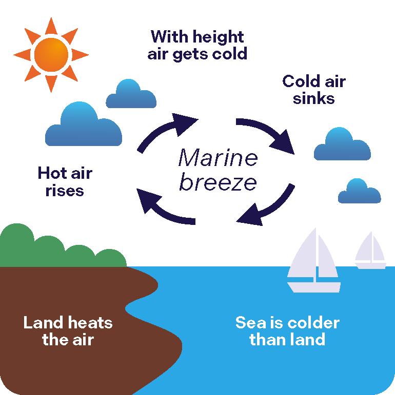
It is the movement or current of air coming from a specific direction. This air movement is a result of an intrinsic property of gases, where cold air sinks and warm air rises.
Cold air
Hot air
It moves because its density changes due to temperature, meaning it sometimes becomes heavier and other times lighter, preventing it from remaining still. When the Sun heats the air, it becomes less dense, the particles spread apart, and as it becomes lighter, it starts to rise towards the clouds. In meteorology, it is defined as the movement of air from an area of high pressure to an area of low pressure.
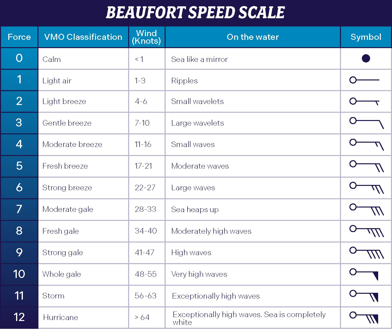
Wind Force Measurement Scale
The Beaufort wind force scale, is an empirical measure of wind intensity based primarily on the state of the sea, its waves, and the wind’s strength.
The scale was created by Sir Francis Beaufort, a navigator in the service of the Crown and an Irish hydrographer, around 1805. Before 1800, officers made regular weather observations, but there was no “scale,” and the measurements were very subjective.
Initially, there were no wind speeds, just a set of qualitative conditions from 0 to 12 was detailed, describing how a ship would behave under each condition,
from “barely enough to maneuver” to “unsustainable for sails.” The scale became a standard part of the logs for British Navy ships in the late 1830s.
It was adopted for non-naval use starting in the 1850s, when Beaufort numbers were associated with the number of rotations of an anemometer to measure wind speed.
In 1906, with the advent of steam power, the descriptions were changed to how the sea behaved and extended to observations on land. Meteorologist George Simpson, director of the Meteorological Office, added these descriptors for land.
CON CLU SIO NS
The Cartagena de Indias Wind Rose is the nautical identity symbol of Cartagena’s and Colombian citizens.
It contains reference points, direction, speed, frequency, and weather season when the prevailing winds occur. Additionally, it features culturally adopted names for these winds, accompanied by fantastic stories that invite to fly with imagination and offer an insight into local nautical customs and histories.
All of this is integrated in “The Rose Twilight” illustration with elements of the port cartography, its geography, its fauna, its flora and its history, with symbols that represent monuments and outstanding ar-
chitectural landmarks of the city, which are appreciated by sailors and tourists when they approach to the city through its maritime access channel or navigate its coasts.
REFERENCES
REFERENCES
Introduction
delagracia.de/indias.htm-El viaje descubridor Cap 1
The Cartagena de Indias Wind Rose is the nautical identity symbol of Cartagena´s and Colombian citizens.
It contains reference points, direction, speed, frequency, and weather season when the prevailing winds occur. Additionally, it features culturally adopted names for these winds, accompanied by fantastic stories that invite to fly with imagination and offer an insight into local nautical customs and histories.
All of this is integrated in “The Rose Twilight” illustration with elements of the port cartography, its geography, its fauna, its flora and its history, with symbols that represent monuments and outstanding architectural landmarks of the city, which are appreciated by sailors and tourists when they approach to the city through its maritime access channel or navigate its coasts.
The Cartagena de Indias Wind Rose, is a nautical cultural symbol that generates belonging among Colombians and encourages foreigners to travel to the Caribbean and get to know this beautiful city and fantastic port.