
2 minute read
Information Services


2018 Initiatives
¢ Work to align RDCO employee, skills and talent with strategic planning initiatives to ensure a high level of customer service.
Advertisement
¢ Maintain positive Labour Relations with the union and all staff.
¢ Foster a corporate culture of safety within the RDCO through effective communications, training and enhanced practices and procedures and continue to support and participate in Health and Safety programs.
Richard Bruneau, MANAGER & CHIEF INFORMATION TECHNOLOGY OFFICER
What We Do…
The Information Services Department combines Geographical Information Systems (GIS) and the Technical support staff for the Regional District. The focus of the department is to oversee the integration of corporate applications and work with all departments to improve the utilization of technology.
The Regional District of Central Okanagan provides GIS and geo-spatial data information to the District of Lake Country, District of Peachland and the Westbank First Nation for the updating, processing and hosting of Core Geographical Information. This collaborative effort provides for significant financial savings to participating local governments and enables the utilization of “geospatial” information and technologies to play a vital role in enhancing public and private sector decision-making.
Our Geographical Information Systems department is continuously enhancing the applications and services it provides. The central application is a website that utilizes the latest technology from Environmental Systems Research Institute (ESRI).
Protecting the integrity and security of Information within the Regional District is a key component. External auditors test and evaluate our infrastructure and we work constantly to improve and keep our systems secure.
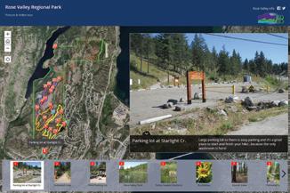
¢ Enhanced Park Mapping Utilizing Virtual Tours.
¢ Enhance Security procedures based on 2017 Security Audit.
¢ Assisted in the evaluation of Strategic Reporting Software.
¢ Integrated new RCMP building and Parks buildings onto internal RDCO network.
¢ Integrated four RDCO paid-on-call fire halls into corporate network and file systems.
¢ Replaced Web Browsing security software.
¢ Security Audit - internal penetration testing and remediation.
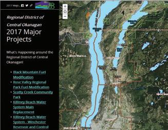
¢ Developed new web-based GIS Mapping site.
¢ In conjunction with Parks Services staff created and implemented new Regional Parks Map Tour online application.
¢ Provided mapping services during Emergency Operation Centre activations for EOC staff and through the public cordemergency.ca website.
2017 Highlights
¢ Implemented new Firewall Security Technologies.
¢ Migrated network on to new Firewalls with Policy based routing.
¢ Implemented the New BC assessment data structure.
¢ Upgraded existing mapping applications to utilize the new data structure.
2018 Initiatives
¢ Obtain and integrate new Ortho-photography for the region.
¢ Initiate the integration of financial systems infrastructure.
¢ Work with Alarm Control to implement new customer facing systems.
¢ Retire legacy firewalls and simplify network routing.
¢ Implement Cisco Advanced Malware Protection.
¢ Upgrade new Server and Storage infrastructure.
¢ Begin the migration of GIS mapping applications away from Silverlight.
¢ Upgrade existing mapping applications.
¢ Enhance Park Mapping utilizing Virtual Tours.
¢ Enhance Security procedures based 2017 Security Audit.
¢ Assist in the implementation of Strategic Reporting Software.
¢ Maintain and enhance GIS data for Environmental Services Department.
¢ Continue to explore technology opportunities within Regional Parks.


