
4 minute read
Planning Section


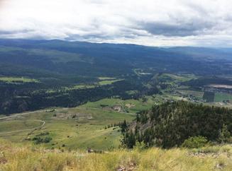
What We Do…
Under the Planning function, we develop land use policies that provide guidance to elected officials, developers, the public and other decision makers. We are responsible for developing and implementing land use plans and environmental protection guidelines, regulations and initiatives. Staff evaluates applications and provides recommendations to the Regional Board. In the Planning section we assist the public with an understanding and interpretation of provincial legislation, land use regulations, applications, and processes. Activities are geared towards balancing growth with maintaining and enhancing the unique Central Okanagan lifestyle and environment.
Advertisement
2017 Highlights Electoral Planning
¢ Provided a ‘one counter’ service using cross-trained staff that can respond to all initial inquiries concerning development issues.
¢ Provided one-on-one meetings with members of the public to advise potential applicants of applicable processes, policies and legislation.
¢ Administered the operation of the Agricultural Advisory Commission, Environmental Advisory Commission, and Advisory Planning Commission – Central Okanagan West
¢ Continued review and updates of Zoning Bylaw No. 871
¢ Continued to pursue discharge of Land Use Contracts in accordance with Bill 17 by initiating an application to discharge one Land Use Contract.
¢ Commenced policy review of whether secondary suites should be considered as a permitted use within specific zones/land use designations
¢ Processed a number of owner-initiated current planning applications
¢ Continued to collaborate with member municipalities, the Ministry of Agriculture and Agricultural Land Commission to develop consistent regulations for Temporary Farm Worker Housing in the region.
Regional Planning
¢ Participated in a sub-committee of the Sustainable Transportation Partnership Inter-municipal project and Central Okanagan Planning Study
¢ Commenced implementation of Phase 2 of the Regional Floodplain Management Plan
¢ Participated in the Central Okanagan Air Quality Technical Committee
¢ Participated as a member of the Okanagan Adaptation Strategies Working Group and assisted in the implementation of the Okanagan Regional Agricultural Adaptation Strategies in conjunction with the BC Agriculture and Food Climate Action Initiative and other stakeholders.
¢ Assisted BC Hydro with the West Kelowna Hydro Transmission Project by providing information, mapping and technical support.
¢ Administered the operation of the Regional Growth Strategy (RGS) Steering Committee
¢ Received Regional Board endorsement of the RGS Priority Projects Plan (i.e. five year action plan) that will assist in implementing the RGS.
¢ Together with inter-regional partners, finalized an InterRegional Monitoring and Evaluation Program (State of the Basin Report 2016) to track progress on issues which transcend jurisdictional boundaries.
Environmental Planning
¢ Participated in the Okanagan Collaborative Conservation Program (OCCP), the Water Stewardship Council of the Okanagan Basin Water Board (OBWB), Mission Creek Restoration Initiative (MCRI) and Species and Ecosystems at Risk Local Government Working Group
¢ Continued partnership toward implementation of a BioDiversity Conservation Strategy for the North and Central Okanagan including working with the University of BC Okanagan on Planning for Ecosystem Connectivity in the RDCO.
¢ Contributed to the multi-phase Okanagan Wetlands Strategy.
¢ Collaboration with OBWB and the Okanagan Nation Alliance (ONA) on the operation of a hydrometric station on Shorts Creek to assist in Flood Management and Source Water Protection.
We develop and implement land use plans and environmental protection guidelines for the electoral areas.
¢ In partnership with OBWB, OCCP, SOSCP, and member municipalities prepared a communication strategy to deliver the key components of the 2016 Okanagan Lake Foreshore Inventory and Mapping Update Report.
¢ In partnership with OCCP and member municipalities, conducted updates to the environmental inventories and mapping for RDCO, primarily Mission Creek and Okanagan Lake Foreshore Inventory and Mapping.
¢ In partnership with OCCP, SOSCP and member municipalities, developed an outreach program based on a recommendation of the 2016 FIM Update Report identifying the need for increased public awareness and education in regards to development occurring on the foreshore of Okanagan Lake.
2018 Initiatives Electoral Planning
¢ Promote enhanced communication to the public by updating all brochures, information packages and the RDCO website.
¢ Continue to pursue discharge of Land Use Contracts in accordance with Bill 17.
¢ Continue with policy review of whether secondary suites should be considered as a permitted use within specific zones/land use designations.
¢ Review and update RDCO sample covenants related to environmental protection and subdivision.
Regional Planning
¢ Continue to implement Phase 2 of the Regional Floodplain Management Plan to address flood hazard and risk in the Central Okanagan.
¢ Continue participation in the Central Okanagan Air Quality Technical Committee.
¢ Continue to assist in the implementation of the Okanagan Adaptation Strategies by participating as a member of the Working Group.
¢ Implement prioritized projects scheduled for Year 2018 as outlined in the RGS Priority Projects Plan based on Regional Board budget approval.
¢ Commence hosting Regional Planning Labs.
Environmental Planning
¢ Contribute to finalizing the Okanagan Wetland Strategy.
¢ Participate with the Water Stewardship Council, Okanagan Collaborative Conservation Program (OCCP), Mission Creek Restoration Initiative (MCRI) and Species and Ecosystems at Risk Local Government Working Group.
¢ Take part in the implementation of the Bio-Diversity Conservation Strategy in conjunction with OCCP and partners to prepare an implementation strategy for the Ecosystem Connectivity Corridor from Okanagan Mountain Provincial Park to Kalamalka Lake Provincial Park, identified through the University of BC Okanagan as part of the Planning for Ecosystem Connectivity in the RDCO.
¢ Ensure consistency among OCP/RLUB Development Permit Area provisions by updating Development Permit regulations and updating Hazardous Conditions Development Permit Area Mapping and Guidelines. Continue to implement the recommendations of the Foreshore Inventory and Mapping and the Aquatic Habitat Index for Okanagan Lake by conducting outreach activities to encourage foreshore and riparian management along the lake, while offering practical ways to restore and enhance natural areas.
- Conduct and update environmental inventories and mapping for use in processing applications, in GIS apps, environmental initiatives and monitoring.
- Explore options for increased shoreline management of Okanagan Lake at a mutli-jurisdictional level (municipal, regional, provincial, and federal) along with OCCP, SOSCP, and all applicable agencies.
- Conduct watershed improvements, stream restoration, monitoring work and outreach activities.
- Continue Environmental Assessments for existing small lot rural subdivisions as part of the implementation of Development Permit Area regulations.
¢ Collaboration with OBWB and the Okanagan Nation Alliance (ONA) on the operation of a hydrometric station on Shorts Creek to assist in Flood Management and Source Water Protection.
Community Services Infrastructure
North Westside Waste Transfer Station
Regional Crime Prevention and West Kelowna Community Policing West Kelowna RCMP Detachment
North Westside Fire Hall Station 101
North Westside Fire Hall Station 103
North Westside Fire Hall Station 102
Wilsons Landing Fire Hall Station 42
Traders Cove Waste Transfer Station
Westside Residential Waste Disposal and Recycling Centre
CITY OF WEST KELOWNA
Westside Regional Wastewater Treatment Plant
OF PEACHLAND
Crime Stoppers and Victim Services
RCMP Doyle Avenue Detachment
Peachland Community Policing and Citizen Patrol
Lake Country Community
Policing and Citizens Patrol
RCMP Detachment
LEGEND
Water Purveyor Area
Dietrich (Star Place)
Falcon Ridge
Killiney Beach
Sunset Ranch
Upper FintryValley of the Sun/Shalal Road
Westshore Estates
Fire Protection Area
North Westside
Ellison
June Springs
Lakeshore Road
Brent Road
Wilson’s Landing
Joe Rich
Ellison Fire Hall Station 61


