City of Greenwood DOWNTOWN DEVELOPMENT PLAN
March 2016


March 2016

Project Goals
Design Program
Existing Conditions
Plan Framework Plan Details Implementation
Build off of the 2014 Downtown
Revitalization Plan - refine recommendations into manageable size projects Develop detailed concepts for key projects Develop presentation graphics to grow public support Identify catalyst projects to spur private investment
Develop project cost opinions
Create an implementation and phasing strategy
PROJECT IDEA #2:
REDEFINE MAIN STREET AND MADISON AVENUE WITH A REVITALIZED STREETSCAPE, RECONFIGURED ON-STREET PARKING, AND ENHANCED PEDESTRIAN AMENITIES.
Rede ning Main Street and Madison Avenue by providing streetscape elements as outlined below is essential for improving the aesthetic quality of downtown Greenwood.
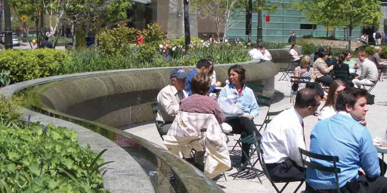
Develop and interface between the buildings and the roadway to provide pedestrian priority, security, and comfort.
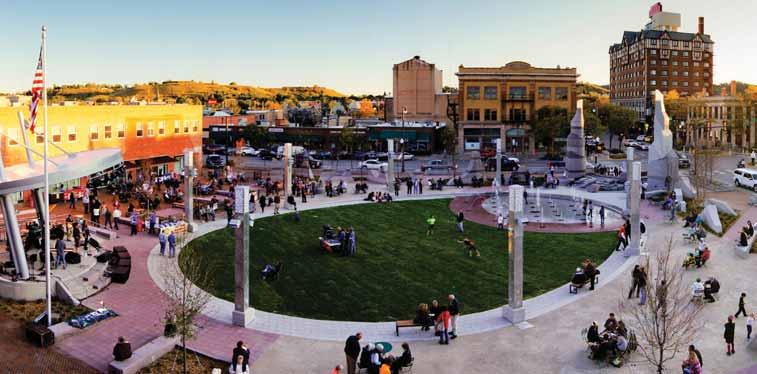
Create attractive and inviting spaces which allow people to relax in a casual atmosphere.
Provide safe, comfortable, and universally accessible walking conditions throughout downtown.
Enhance the downtown environment by providing visual variety and appropriate contextual cues such as engaging storefronts, outdoor seating, and onstreet retail displays
Design high quality details throughout the public realm which indicate the importance of the space, stimulate social interaction and solidify developer commitment.


48
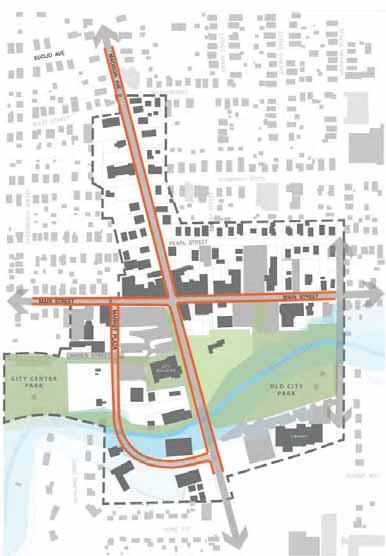
Streetscapes
Main Street
Madison Avenue
Market Plaza
Intersection improvements
Main and Madison
Main and Market Plaza
Madison and Market Plaza
Main and Meridian
Improve roadway connectivity Connect existing trail segments with parks and civic destinations
Old City Park improvements Signature public gathering space
Infill and redevelopment sites
City Center parking lot
Middle School site
Other City-owned and key properties
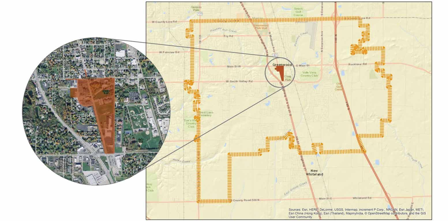
Study Area:53.3 acres
Miles of Street:1.86 miles
Acute angles at Main and Madison create difficult turn movements
High traffic volumes along Main St. from US 31 to I-65
No east-west connectivity between Main St. and Smith Valley Road
Lack of barriers between Market Plaza and adjacent parking lots

Study Area:53.3 acres
Flood Area:10.6 acres
%:19.9 %
Almost all of Old City Park is within the floodplain
Limited redevelopment potential along southern portion of Market Plaza because of floodplain
Constricted flow at Madison and Market Plaza bridges during high water

Study Area:53.3 acres
Park Space:5.0 acres
%:9.4 %
Trails:0 miles
Significant park space in and around the downtown
No trail connections from Community Center, Craig Park, and Surina Square Park to Old City Park and City Center Park
Community Center renovation planned
Trail connection from Surina Square Park through Craig Park to Polk Hill Trail planned

Study Area:53.3 acres
City-Owned*:15.1 acres
%:28.3 %
In Process**:17.3 acres
%:32.5 %
*Parcel area does not include right-of-way
**Noted with hatching on map
Quantity of city-owned property in the downtown is an opportunity but currently contributes little to tax base
Middle School site in process of purchase
Several other properties in negotiation or discussion

Opportunities to improve both street function and appearance
Turn limitations at Main and Madison will necessitate additional connectivity improvements
Flood plain limits type of park improvements and redevelopment along south Market Plaza
Concentration of civic features and public spaces can be used as basis for additional amenity infrastructure
Redevelopment sites can be used to increase commercial critical mass, downtown residential population, and ultimately City tax revenues
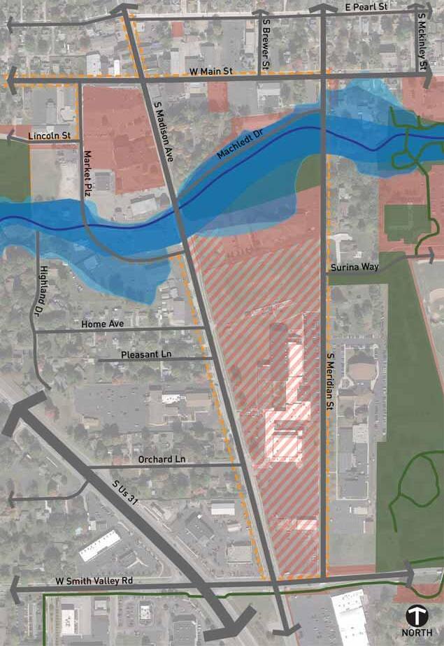
Study Area:53.3 acres
Miles of Street:1.98 miles +0.12 miles
Removal of Machledt Dr.
Connection between Market Plaza and Surina Way
Continuation of Orchard from Madison Ave. to Meridian St.
Additional east-west connection between Madison Ave. and Meridian St.
Roundabout at Madison Ave. and Smith Valley Road

Pleasant Creek course adjustment through Old City Park
Addition of weirs and pond
Limited change to floodplain without additional upstream improvements
Explore opportunities for stormwater mitigation in new development and streetscapes

Study Area:53.3 acres
Park Space:9.9 acres +4.9 acres
%:18.6 %
Signature public gathering spaces adjacent to City Center
Active open space around re-purposed Middle School gymnasium
Open spaces to support increased residential population
Two trail connections from east park spaces, through Old City Park and City Center, connecting to City Center Park

Study Area:53.3 acres
Redevelopment
Blocks: 20.3 acres
%:38.1 %
City Center surface parking lot
Under-utilized, vacant, and surface parking lots south and west of City Center
Middle School site, potential for one master developer or split into several separate pieces

Improved roadway connectivity
Active streetscapes
New bicycle and pedestrian facilities, connecting community destinations
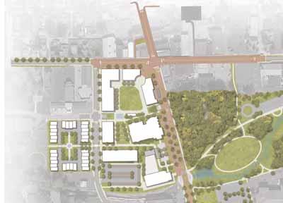
20+ acres of infill and redevelopment
Signature open spaces woven throughout redevelopment sites
Opportunity to establish a new standard of development for Greenwood, which incorporates sustainable site principles and on-site stormwater management


Approximate 59’ right-of-way
Narrow (6’) sidewalks
Multiple turn lanes increase crossing distance and consume pedestrian/ amenity space
Streetscapes
(west of madison) -


60’ right-of-way
Remove turn lanes
Add on-street parking
Widen sidewalks
Shorten crossing distance
Create buffer/amenity spaces
Stormwater planters and bump-outs
Brick streetscape

Approximate 44’ right-of-way
Narrow (7’) sidewalks
Sidewalk obstructions
Poorly defined travel lane/parking lane/ turn lane
Established building frontages prevent right-of-way expansion


44’ right-of-way
Remove on-street parking and turn lane
Wider sidewalks with amenity space for pedestrian-scale lighting, planters, site furnishings
Brick streetscape

Approximate 44’ right-of-way
Narrow (5’-6”) sidewalks
Sidewalk obstructions
Established building frontages prevent right-of-way expansion

of main)


44’ right-of-way
Remove on-street parking and turn lane
Wider sidewalks with amenity space for pedestrian-scale lighting, planters, site furnishings
Brick streetscape
to market plaza)

Approximate 50’ right-of-way
Narrow (3-6’) sidewalks
Wide travel and center turn lanes

(main to market plaza) -


68’ right-of-way
Add on-street parking
Widen sidewalks Create buffer/amenity spaces
Stormwater planters and bump-outs
Brick streetscape
Planted median/turn lane
(south of market plaza)
Approximate 100’ right-of-way


Varying setbacks and uses along the corridor
Wide travel and center turn lanes
Significant utility easements
Lawn buffer separating sidewalk from travel lanes


97’ right-of-way
Planted buffer
On-street parking/ stormwater planter
Wide sidewalks
Narrowed travel lanes


Approximate 40’ right-of-way
Wide travel lanes
Incomplete sidewalks
Lack of barrier between travel lane and adjacent parking in areas


67’ right-of-way
Planted buffer
On-street parking/ stormwater planters on both sides
Wide sidewalks


51’ right-of-way
Street trees/planted buffer
Wide sidewalks


Commercial
Space:32,015 s.f.
Apartments:78
Parking:374 total 360 structure 14 on-street
Mixed use development: Ground floor retail 2 floors of apartments
2 floor underground garage
Public plaza/events space
Band Shell Spray Plaza
Redline BRT station
Interim bank access from Market Plaza




Commercial
Space:49,815 s.f.
Apartments:146
Townhomes:32
Parking:538 Total
360 structure
69 surface
48 ground floor
61 on-street
Townhomes around central green
Additional 3 story apartment building Re-use of transmission shop
Surface parking lot
Trail connection to City Center Park
Center Area - Final




Commercial Space:n/a
Apartments:n/a
Parking:89 Total
89 two surface lots (does not include library)
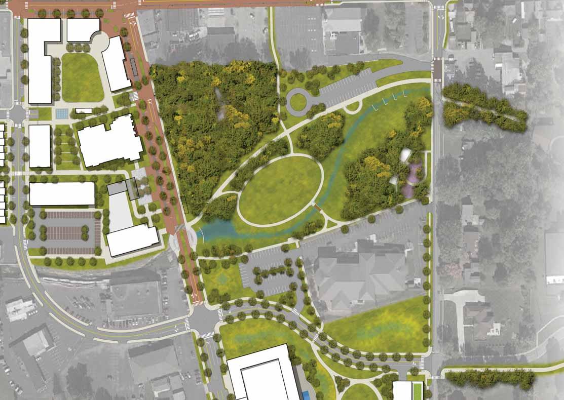
Reconfiguration of Old City Park with weirs and pool along Pleasant Creek
Trail node and creek overlook along Madison
Trail along Machledt alignment
Trail connection to Main St.
New surface parking lot
Redline BRT Station




Commercial Space:n/a
Apartments:212
Townhomes:37
Parking:438 Total
215 structure
25 surface
155 ground floor
43 on-street
Residential infill that respects scale across Madison and Meridian
Apartments wrapped around parking structure
Re-use of Middle School gymnasium
Open space connecting gymnasium to library and beyond


Commercial Space:n/a


Apartments:n/a
Townhomes:54
Parking:17 on-street
Townhomes around central green with connection to gymnasium
Respects scale of development across Madison and Meridian


Commercial Space:27,415 s.f.
Apartments:115
Townhomes:10
Parking:273 Total
215 structure
40 ground floor 18 on-street
Transit-oriented development centered around terminus of Redline BRT
3 and 4 story buildings
Ground floor retail
Apartments above
Parking structure
Urban plaza adjacent to station




Commercial Space:n/a
Apartments:264
Townhomes:53
Parking:481 Total
215 structure
223 ground floor
43 on-street
Demolition of gymnasium
Two additional townhome/ apartment buildings
Additional open space connecting townhome central green to library and beyond


Commercial
Space:25,200 s.f.
Apartments:249
Townhomes:29
Parking:594 Total
430 structure
121 ground floor
43 on-street
Demolition of gymnasium
Additional mixed-use/parking structure building (1/2 of first floor square footage is retail in both buildings)
Removal of one townhome/ apartment building
Additional open space connecting townhome central green to library and beyond
RETAIL/OFFICE (S.F.)APARTMENTS (S.F.)TOWNHOMES (S.F.)
8,30016,6005,79011,58017,92535,8507,80015,600-39,00010,000---32 @ 2,000 ea. -75,600-
-20,4008 @ 1,400 ea. -20,4008 @ 1,400 ea.
-17,8007 @ 1,500 ea. -17,8007 @ 1,500 ea. -17,8007 @ 1,500 ea. --54 @ 2,000 ea.
13,91527,83013,50041,400-24,00010 @1,400 ea.

City Center Area$30,002,300 $740,069
Middle School - North$25,926,000 $666,780
Middle School - Center$13,500,000 $135,000
Middle School - South$17,202,300 $486,069 GRAND TOTAL$86,630,600 $2,027,918
Middle School - North (Gym Alternate 1)
$33,222,000 (+$7,296,000) $837,660 (+170,880) GRAND TOTAL$93,926,600 $2,198,798
Middle School - North (Gym Alternate 2)
$32,862,000 (+$6,936,000) $898,860 (+232,080) GRAND TOTAL$93,566,600 $2,259,998
STREETSCAPES$17,088,650
Main St. (Greenwood St. to Meridian St)$3,736,477
Madison Ave. ( Pearl St. to Market Plaza)$3,949,388
Madison Ave. (Market Plaza to Smith Valley Rd)$2,582,390 Market Plaza$2,129,124
Surina Way Extension$2,542,715 Meridian St (Main St. to Smith Valley Rd)$2,148,557
City
Plaza - North Development$5,623,855 Parking Garage (360 Spaces / two levels)$11,000,000
Plaza - South Development$2,823,485


