3 minute read
BICYCLE FACILITY TOOLBOX OVERVIEW


The City will utilize a variety of bicycle facility types in order to meet the needs of bicyclists of all abilities and to respond to the unique characteristics of individual roadways, including traffic volume, traffic speed, and availability of road rightof-way.
LOW-STRESS BICYCLE FACILITIES
Advertisement
Shared Use Path Cycle Track
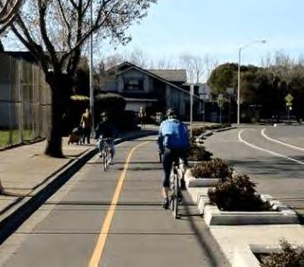
Shared use paths are physically separated from motor vehicle traffic and provide shared space for twoway bicycle and pedestrian traffic. They may be located parallel to roadways or in areas outside of the roadway network, such as in parks or along rivers.


Shared use paths should be a minimum of 10 feet wide to accommodate bidirectional traffic and both bicyclists and pedestrians.
A cycle track is an exclusive facility for bicyclists that is physically separated from motor vehicle traffic by vertical elements.
Cycle tracks may be one-way or twoway and may be at street level, at sidewalk level, or at an intermediate level. If at sidewalk level, a curb separates them from motor vehicle traffic while different pavement color or texture separates the cycle track from the sidewalk. If at street level, the cycle track can be separated from motor vehicle traffic by bollards, raised medians, flexible delineators, or on-street parking.
Cycle tracks are differentiated from conventional and buffered bicycle lanes by the vertical element that separates them from motor vehicle traffic. Cycle tracks are sometimes called “protected bicycle lanes” or “separated bicycle lanes.”
Neighborhood Bicycle Route
Neighborhood bicycle routes are streets with low motor vehicle volumes and speeds where bicyclists share the roadway space with motor vehicle traffic. On neighborhood bicycle routes, traffic calming measures are implemented as needed to enhance comfort for bicyclists and to further minimize motor vehicle traffic volumes and speeds. Neighborhood bicycle routes are identified by signage and pavement markings and should be complemented by sidewalks on both sides of the street.
Neighborhood bicycle routes are differentiated from rural bicycle routes, which are also shared road bicycle facilities, by their location and traffic volumes/speeds. Neighborhood bicycle routes are located on low-volume, low-speed, in-town streets where traffic calming is utilized to further improve the bicyclist experience. Rural bicycle routes, conversely, are located along preferred routes in rural areas with higher traffic volumes and speeds.
The following facility types are part of Columbus’ bicycle facility “toolbox.” Sidewalks are not included in this toolbox but inexperienced bicyclists and children are permitted to use sidewalks when no on-street bicycle facility is available or when they are uncomfortable using the provided on-street bicycle facility. See pages 84-103 for design guidelines and more information about the bicycle facilities below.
Buffered Bicycle Lane Bicycle Lane Rural Bicycle Route
Buffered bicycle lanes are on-street dedicated lanes for bicycle travel separated from motor vehicle traffic by a painted buffer.
Buffered bicycle lanes may be one or two-way facilities and are intended for exclusive use by bicyclists.
Conventional bicycle lanes are onstreet dedicated lanes for bicycle travel adjacent to vehicle travel lanes.
Bicycle lanes are one-way facilities that parallel the direction of travel and are located on each side of a two-way roadway or one side of a one-way roadway.

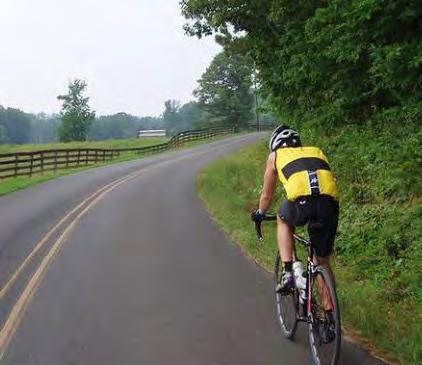
Rural bicycle routes are a system of signs and pavement markings that guide bicyclists along preferred routes in rural areas outside of the Columbus city limits.
Bicycle routes are used to identify preferred routes where bicycle infrastructure is not needed or is not feasibile.

Bicycle Facility System Map
This map identifies Columbus’ existing bicycle network and the approximately 157 miles of proposed new bicycle facilities.
NOTES:
Some of the existing shared use paths do not meet current width standards and should be widened in the future to meet minimum standards.
The proposed facilities shown on this map are based on existing best available data and street conditions. Proposed facilities are also aspirational, reflecting the best future conditions for bicyclists and pedestrians. As designs progress, facility types and routes may be altered.
Recommended Existing
RURAL BICYCLE ROUTE
NEIGHBORHOOD BICYCLE ROUTE
BICYCLE LANE
BUFFERED BICYCLE LANE
CYCLE TRACK PARK SCHOOL
SHARED USE PATH
COLUMBUS PLANNING JURISDICTION (STUDY AREA)
Note: Proposed Shared Use Path and Cycle Track to replace existing Neighborhood Bicycle Routes
CliftyCreek
HawCreek Sloan Branch
BICYCLE FACILITY SYSTEM MAP: CITY ENLARGEMENT
This map is an enlargement of the project area, providing more detail in the Columbus urbanized area.
NOTES:
Some of the existing shared use paths do not meet current width standards and should be widened in the future to meet minimum standards.
The proposed facilities shown on this map are based on existing best available data and street conditions. Proposed facilities are also aspirational, reflecting the best future conditions for bicyclists and pedestrians. As designs progress, facility types and routes may be altered.
Clifty Creek
Recommended Existing
RURAL BICYCLE ROUTE
NEIGHBORHOOD BICYCLE ROUTE
BICYCLE LANE
BUFFERED BICYCLE LANE
CYCLE TRACK PARK SCHOOL
SHARED USE PATH
COLUMBUS PLANNING JURISDICTION (STUDY AREA)


