4 minute read
Need for Improved Forest Inventory

from PNGAF MAGAZINE ISSUE # 9D 2 of 15th October 2021 THE DEVELOPMENT OF PNG'S FOREST MANAGEMENT SYSTEMS
by rbmccarthy

The Need for Improved Forest Inventories.
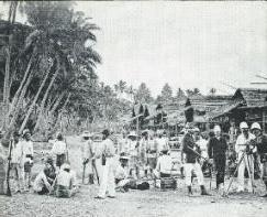
Source 1959 Commonwealth Dept. of Territories. An expedition preparing to set out from Port Moresby in 1885 for the crest of the Owen
Advertisement
Stanley Ranges.
FAO reported in 2020 that of PNG’S total land area of 46.2 million hectares, several estimates have been given for the total forested areas in the country. For example, in 1975 it was estimated that a total of 33.667 million hectares were covered with forests, and this was reduced to 29.4 million hectares of which 25.2 million hectares were still intact in 2005 (FRA, 2005). In a recent report, Shearman et al. (2008) reported that the total forest area in 1972 was 33.227 million hectares and this was reduced to 28.2 million hectares of which 25.3 million hectares were still intact in 2002. The Government agency responsible for forestry, the Papua New Guinea Forest Authority (PNG FA) estimates the forested areas to be 29 million hectares with 24 million hectares still intact. Some of these reports have also given differing percentages for annual deforestation rates per year; 0.5 percent (FRA, 2005) and 1.41 percent (Shearman et al., 2008). Due to these differences, there is a need for PNG’s forest areas to be further verified using such technology as remote sensing. In 1975, PNG had a total forest cover, based on an assessment using aerial photography, of 33.065 million hectares of forest.
These assessments were done under the administration of the Australian Government, with CSIRO heavily involved in carrying out natural resource surveys in PNG. There was not much heavy demand placed on the forests to meet the country’s developmental needs during the early 1960s and 1970s.
Hence the decline in forest cover during that period was much lower than in the mid-1980s to 2000. A rapid decline in forest cover took place between the mid-1980s due to an increase in global and especially regional demand for round wood logs as well as the demand for food due to increase in population.
Whilst PNG has been reported as having a forest cover of between 28 and 29 million hectares, these figures have still to be verified using remote sensing. Expert opinion is that there is more forest area than has been reported, since forest losses were reported based on the area of forests that were under production, but which were being selectively logged (rather than cleared). Hence in terms of forest cover, the areas still under forest should be greater than calculated because many of the logged over areas have not been converted to other land use such as large-scale agriculture. PNG has reported a growing stock of some 1.035 billion m3 of wood of which approximately 50.7 percent is designated for wood production and other commercial use. From other woodlands it was reported that there were some 4.474 million hectares though no growing stock estimates were provided as data were lacking on these areas (FRA, 2005). PNGAF magazine issue # 9B-5A of th 8th of June 2021, described the history of assessment of PNG’s Forest Resources till 1975. What of tomorrow?
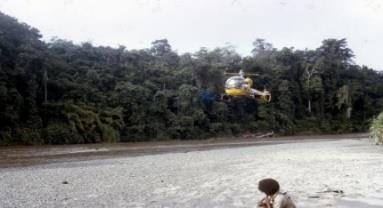
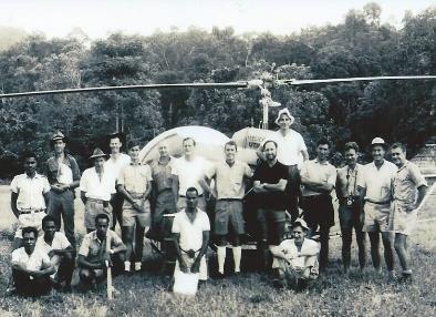
Photo Mosaic Legend - top to bottom, left to right.
Year Location Characters Photo credit
1964 Derembat Manus Going ashore. 1970 Tiauru Pandi Survey Camp HQ Dick McCarthy, Bob McKeowen, Francis Tigi.
1967 Ioma Communicating by field radio to base at Ioma.
Ken Granger Dick McCarthy
Chris Borough
1966 Bill Wallace helicopter pilot. Ken Granger
1944 Lae
1944 Lae
1967 Kumsi Lt J S Talbot surveyor; WO 2, W Spencer, draughtsman, and Sgt H M Crossley outside drawing office of 1 Forest Survey Coy 1944. Warrant Officer 2 W Spencer using stereoscope on aerial photographs 1 Forest Survey Coy. Eric Hammermaster, Gary Flegg, John Davidson, Bill Wallace.
1970 Vanimo
Vanimo Survey. 1970 Pual River Vanimo Essential item. Aust War Memorial
Aust War Memorial
Ken Granger
Ian Whyte Mike Jones
1972 General 1963 Gogol Archer tree height converter wheel. Gary Archer Crossing Gogol River. Mary Jenkin
1964 Bougainville Advance party Roading toward Toimonapu Plantation. Bougainville. Peter Eddowes
1963 Gogol Gogol Survey 1963 Evan Shield, John Lowien, Eric Hammermaster, Bill Jenkin, Norm Endacott, Kevin White. Mary Jenkin
1967 Ramu 1970 Gogol 1963 First helicopter Survey. Gogol TA A typical cleared heli pad. Bush Survey Camp. 20Gogol Survey Boss Boys 1963 L to R Norm Endicott, Johnny Lowien, David “dokka” Reid, Eric Hammermaster, Jim Cavanaugh, Evan Shield, Peter Eddowes, Pilot Hurrell, Don McIntosh, Bill Jenkin, unknown, unknown, Kevin White, unknown. Ken Granger Ian Whyte Mary Jenkin
1968 Kassam Pass area Alick and Molly Dockrill. 1964 Empress Augusta Bay Bougainville Toneli Harbour Bouganville Ken Granger assessment in Terminalia brassii swamp forests Survey Sept-Oct 1964. Money in the swamp photo. Mark Coode Ken Granger
1970 Vanimo Weighing wood samples Evan Shield, Dick McCarthy. Ian Whyte
1964 Empress Augusta Bay Bouganville Measuring T brassii Mom Hill swamp. Ken Granger
1970 Tiauru Pandi Bialla Found a tree or two.
Dick McCarthy 1970 Ossima Vanimo Ceremonial burning haus pek pek. Ian Whyte 1855 Near Port Moresby Expedition Port Moresby to crest of Owen Stanley Ranges. Dept of Territories
1968 Tabibuga Patrol Post Jimi Valley Survey Villagers clustered around the helicopter. Paul Ryan


