

rantao0328@gmail.com
+44 07514022521
Sheffield,UK
rantao0328@gmail.com
+44 07514022521
Sheffield,UK
Education Work Experience
2020-2025 Sep 2023- Aug 2024
Landscape Architectrue(MLA)
University of Sheffield,UK
2024-2025 Study Abroad
Landscape Architectrue
Chiba University,Japan
Scholarship/Award
LDA design competition
2023 Winner
JASSO Scholarship,Japan
Undergraduate Scholarship,UK
Year-Out Landscape Architect
Planit Landscape Architect,Manchester,UK
-Assisted the team in delivering projects from RIBA Stages 2-6, contributing to concept development, detailed design and technical documentation.
-Developed 3D models, visualizations, and technical drawings to support planning applications and client presentations.
-Engaged in interdisciplinary collaboration with architects, planners, and engineers to deliver site-responsive and context-driven designs.
Key projects worked on:
-Central Retail Park, Manchester
-Ancoats Green Public Park, Manchester
-First Street Residential & Commercial Development, Manchester
-Science and Industry Museum, Manchester
Software
Adobe Suite
Vectorworks
AutoCAD
Sketchup
Language
Chinese
English
Japanese
-Victoria North & A62 Road Development, Manchester
-Central Way Restaurant Terrace,Altrincham
June 2021- Aug 2021
Assistant Landscape Architect
UC Landscape Architect,Shenzhen,China
Assisted in residential landscape projects, contributing to construction drawings, design development, and technical detailing. Gained experience in project documentation and collaborated with the team to refine design solutions.
2022- 2023
University Student Ambassador
Twinmotion representing the university in outreach and recruitment events. Responsibilities included campus tours, mentoring, and engaging with prospective students and educators. Gained training in customer service, developing strong communication, reliability, and engagement skills while supporting diverse audiences across various initiatives.
I am a dedicated landscape architecture graduate with a strong foundation in design, research, and spatial planning.
My expertise lies in crafting site-specific, well-integrated landscapes that respond to environmental, material, and seasonal dynamics. With a keen eye for aesthetics and functionality, I strive to create thoughtful, enduring spaces that enhance both ecological and human experiences.
Beyond design, I have a deep appreciation for photography, which sharpens my attention to light, composition, and detail—qualities that enrich my approach to landscape architecture. I am eager to contribute my creativity and problem-solving skills to a dynamic team.
University Works

Rise From The Remains. Doncaster Minster Area Redevlopment


Professional Works

Masterplan Rendering.

Technical Drawing.


Report
Others

3D rendering. Zine & Photography
Doncaster new art and culture centre: reinterpret history through landscape
Lumion,Photoshop,Sketchup
The city is constantly evolving and innovating, leading to changes in its architecture and landscape to meet the needs of society. Unfortunately, these changes can also alter the character of the local landscape and result in the demolition of valuable features.
The church area of Doncaster has significant historical value.The Roman Empire invaded Britain and built a fort in this uninhabited area,which later beame the start of the Doncaster city. Over time, the landscape has undergone numerous alterations. In 71 AD, the Roman fort covered the entire area.
In the 1800s, a new church building was constructed, along with schools and residential buildings throughout the area. In the early 2000s, all buildings except the church were demolished and replaced with a large B&M home store. Now, the B&M store is planned to be demolished again, and the landscape will undergo another major change.

In this constantly-changing landscape, I aim to explore creating a new landscape that incorporates historic elements from different eras. My idea is to use previous footage and scenery to create an immersive experience for visitors. By presenting elements from different historical eras in a new and engaging way, I hope to help people connect with the area’s history and appreciate its significance.
The concept of reinterpreting and recreating the past landscape will be incorporated along with the Doncaster Action Plan. Thus my design will focus on enhancing the cultural and artistic offerings in Doncaster, while also providing more functional spaces.


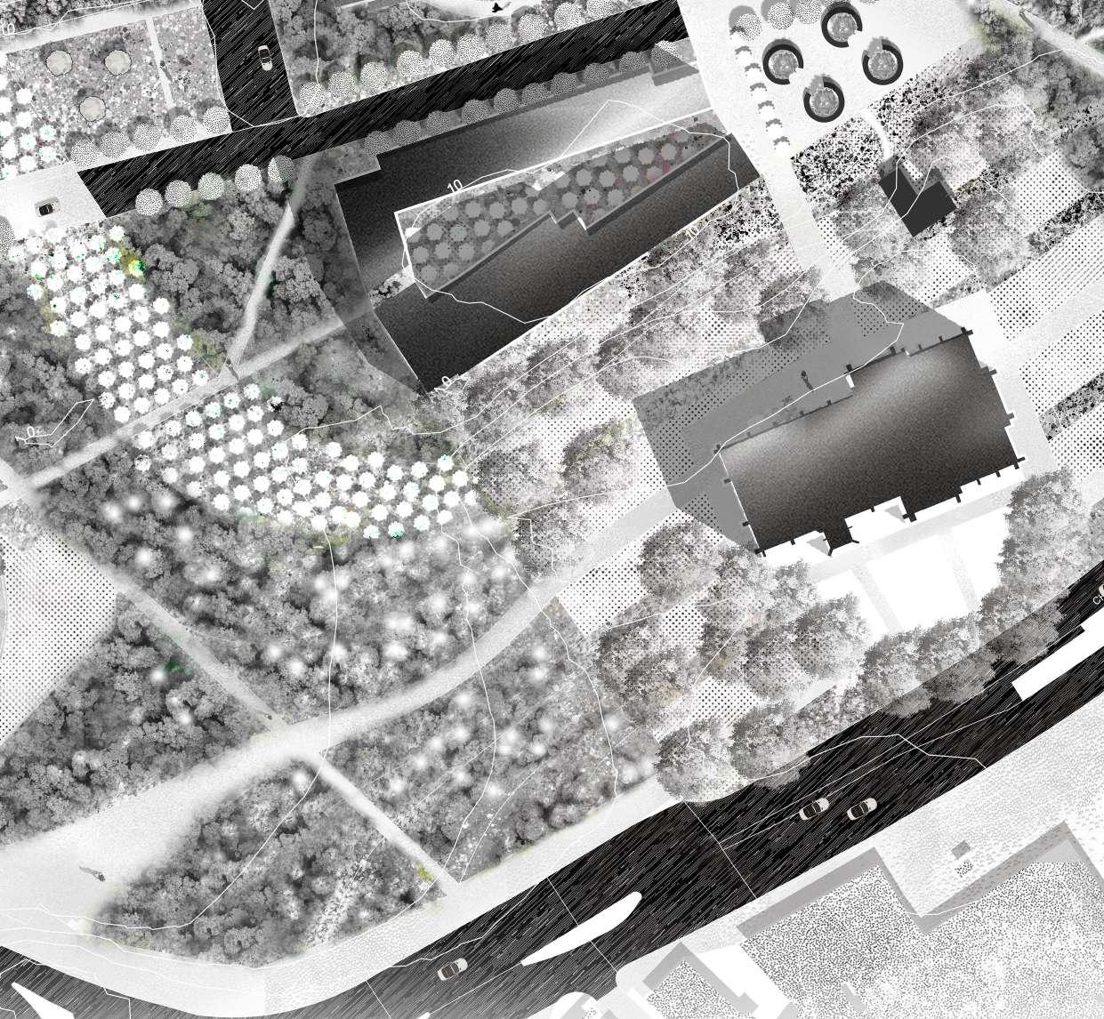
By designing the density of trees,the changed in site functions are clear at a glance. The permanent art exhibition area surrounded by dense forests stands out.I chose the honey locust tree,which has a smaller size and a relatively sparse crown,and dispersed them in a linear arragement. The space formed by such a plant combination will allow people to move freely under the trees. Also trees will cast charming shadows on the ground,provide a unique walking experience.


As an important cultural symbol of Doncaster,the Minster often hosts various ceremonies and events.The linear meadow design leads to the entrance of the church,encouraging and facilitating people's movements. As well as providing an immersive sensory experience.
The amphitheater created by changing the topography provides visitors with diverse performance activities,enhances the cultural life of Doncaster,and enriches the cultural identity of the city.


Detailed design area showcases the landscape design changes from the church to the riverside,focusing on creating different functional spaces through the alternation of soft and hard landscape,emphasizing the concept of changing scenery while walking.

The outdoor art workshop area outside the art college provides frequent workshops to the general public in Doncaster,promoting art education throughout the city.
Converting roads with low traffic volume into partial pedestrian-friendly walkways to encourage pedestrian movement throughout the site.
Waterfront bar and seating area,this space can be used as an event space for weekend markets,festivals,etc.
The Arbourthorne Field is located in the south-east of Sheffield. Most of the housing within this area are council housing, though some of them is now private sector. During the past decades, it has been the focus of housing redevelopment masterplans, with the Arbourthorne Field considered the 'obvious focal point' of the area. However, since 2005, apart from the woodland and dense grass on the edge of the site, which provides a good habitat for animals, the site's simple design has made it of no practical use other than dog walking, and at night it has often attracted anti-social behaviour. This has led to the park being neglected for a long time.


Abourthorne Ecology Park using an ecological way (SuDS) to redefine both the natural and social environment in Arbourthorne Field, Sheffield. A retention basin and two detention basins will help to address both the ongoing issue of run-off water from the new housing development and brief periods of heavy rainfall.
At the same time, it creates various habitats for local animals and vegetation. Meanwhile, some charming recreational spaces are created to meet the need of residents from different age groups.


Project info
/5th year study abroad project

Location: Hakone,Japan
Software used:Photoshop,Sketchup
Once a thriving landscape, the Hakone Arboretum owned by Seibu Group has remained largely abandoned for years, drawing few visitors. However, nestled by the lake within this forgotten space stands Kuzuryu Shrine and Torii Gate over water, renowned for its deeply spiritual presence. Each year, the shrine attracts a large number of worshippers seeking divine blessings.
To transform the arboretum into a unique and meaningful destination, this project expands the sacred pilgrimage experience beyond the shrine, integrating it into the entire landscape. By framing the journey as one of ritual and spiritual purification, the Corridor of Light enhances the act of worship through a carefully curated interplay of light, shadow, and reflection.
Client: Seibu Group


Design Strategies
-Curated vegetation density:Filters and shapes natural light, guiding movement.
-Lake reflections:Creates a dynamic, ever-changing atmosphere that responds to time and weather.
Visitors embark on this extended journey of introspection and renewal, experiencing the transition from prayer to nature in an immersive, contemplative setting. With minimal intervention, the design carefully preserves the existing trees of the arboretum, maintaining its natural character while redefining its cultural and spiritual significance.


Extending the torii’s axis reveals a direct alignment with Mt. Komagatake, a significant spiritual landmark. This project embraces this discovery, establishing a sacred axis that enhances the site’s spiritual presence.

The design incorporates stone materials to emphasize this directional alignment, naturally guiding attention toward the mountain. Surrounding pathways allow visitors to engage with the axis dynamically, reconnecting with it repeatedly as they walk. The sequence of movement offers framed views of the floating torii, while strategically placed picture windows at varying heights create moments of introspection, immersing visitors in a deeply personal and contemplative experience.


Each stone step is designed with a unique pattern, subtly altering the flow and ripples of water, allowing for controlled water movement while enhancing the textural richness of the steps.
As part of the sacred pathway, a thin layer of water remains on the surface, reflecting light and illuminating the linear axis, reinforcing the spiritual atmosphere of the space.


By clearing trees along the central axis, a path of light leads visitors toward the torii gate in the water. Along the trail, glimpses of the sacred axis appear through the trees. Higanbana lines the path, creating a quiet, reflective atmosphere rooted in Japanese spirituality.


The tiered water feature, designed to flow downward like cascading steps, consists of streams and ponds. It is fed by two primary water sources: pumped lake water and collected rainwater replenishment.Additionally, during heavy rainfall, the system functions as a temporary retention basin, reducing surface runoff and preventing soil erosion, contributing to the site’s ecological resilience.

We transformed the open hilltop into a meadow with an elevated path and viewing terrace, ensuring minimal ground disturbance to protect existing animal habitat holes while enhancing the C

This page highlights my strong report writing and analytical skills, developed through university projects focused on landscape assessment, visual analysis, and urban evaluation. I have experience in conducting detailed site studies, structuring technical reports, and presenting data-driven insights, essential for professional LVIA and evidence-based landscape planning.
6.1 6.2 6.3
Section 7.88 to 7.106 of the LVIA describes and evaluates the visual environment and receptors within the study area. This establishes the ‘baseline’ visual situation against which the changes result-ing from the proposed development can be assessed. Our comments on the visual baseline are as follows:
Figure 6. Change of viewpoints.
Black=reomove
Blue=Retain
Green=new


The choice of viewpoints have been made on ZTV analysis and the most relevant viewpoints are listed in the table below. We agreed that the choice of viewpoints’ location is appropriate to some extent. Because though the site is visible from a more extensive area to the north west and south east according to new ZTV and ZVI map, these two areas are too distant from the site, the visual impact of the new development is no longer significant, so the choice made in the original report is correct to a certain extent.
We reduced the number of viewpoints to 13 (removing 13 and adding two new ones) based on the new ztv analysis map and the viewpoint map. We believed that some of the original viewpoints covered a range of visual receptors that overlapped, and many were not representative, so there was no need for them to exist. Moreover, some viewpoints were already outside the boundary of the ztv map, and the viewpoint at these locations is so that the site change would have essentially no effect on the visual receivers here. For detailed reasons for the change, please see table A.
The original ZTV analysis Figure X shows the original Zone of theoretical Visibility (ZTV) of the site, which has been used as the basis for the dentification of visual eceptor groups and representative viewpoints.
We believe The original ZTV is broadly accurate, although compared to what we have done (Figure x), we consider that ZTV should extend further to the south-west to include clear views across the valley from the Dungworth Green to Sykehouse Lane.


Figure.2 Compare New ZTV and old ZTV. Dark green=agreement, Light red=new ZTV can see but Old ZTV can not Light green=Old ZTV can see but new ZTV can not
Figure.3 Combined ZTV and ZVI map, with 1,2,3,5km radius indicator
We made an additional ZVI analysis map, which takes into account the terrain, plants and buildings to obtain more accurate results.
9m&12m
Continuous
(same colour for different gradient) Continuous output (same solid colour, no gradient) Compare Original ZTV and new ZTV 3.4
We believe The original ZTV is broadly accurate. But we noticed that
• The original ztv analysis uses the same color with different gradients to express the extent to which the site can be seen from different locations. However, the map does not indicate what the different gradient levels represent, making it difficult to understand. Moreover, the gradient color causes the map to be blurred in some places, making the reader cannot understand the map very clearly. New ZTV chose to use same color with no gradient to represent the visibility, it’s more clear to understand.
• 7.109 mentioned that the original production of ZTV analysis was based on a 10m average building height, but the actual build from in the proposal is at an average height of 9m, with some part of development planned at 12m (4 storey eave height). New ZTV chose to build the analysis on a more accruate base information, thus the outcome is more reliable, allow for a more precise scope of subsequent field survey.
• The old ZTV is mapped out without a radius indicator, and a radius indicator would help the reader to comprehend the useful information from the map easily. For example, if we put 1,2,3,5km radius indicators in figure1, the reader can easily obtain information about the visible areas within different radius circles from the map. The two separate areas in the northeast and southwest corners of the map are clearly outside the 3km radius range, and we can acknowledge that he visibility of these two areas is already very low, and there is no need to consider them.
We note that this type of residential development raises lighting issues. According to GLIVIA3, it is necessary to demonstrate a nighttime visibility analysis. Furthermore, The survey and definition of visibility ZTVs may require nighttime visibility. As siting, layout, and design suggestions are developed, and lighting effects become evident, the visibility survey and definition of ZTVs need to be evaluated and revised. Former Loxley Works, Sheffield LVIA Review 11


Wythenshawe Town Centre Regeneration Project University of Manchester Student Hall
As part of the team, I was responsible for developing the Stage 2 conceptual masterplan. Collaborating closely with the team leader, I translated his vision and sketches into a refined masterplan rendering, integrating key design principles while enhancing clarity and visual impact.
I was responsible for developing a revised masterplan following my team leader’s meeting with the client. After a brief discussion on the updated vision, I successfully translated the new design direction into a refined masterplan, which was well received by the team.

I worked on this project mostly independently from Stage 2 to Stage 4. I was responsible for developing the design for this restaurant terrace and producing a Stage 4 construction package.
I explored different material palettes, conducted a site visit, and discussed the project with the contractor under the instruction of my studio leader.
In the end, I successfully delivered the drawing package with support from my colleagues.


Software used: Sketchup,Vectorworks,Twinmotion,Photoshop

Greenshoots Mixed Development

Greenshoots Mixed Development
Kelham Island Housing Development
Royton Road Development


Ranpresents | E-zine
A self-published collection featuring my travel photography and writings, documenting experiences and observations along my journey. I regularly share these zines across multiple platforms, combining visual storytelling with personal narratives to capture the essence of places and moments.


My photography captures the subtle beauty of landscapes, seasonal shifts, and the interplay of light and shadow.
Through a blend of composition and atmosphere, I seek to evoke a sense of stillness and connection to place. Each image reflects my fascination with natural transitions and spatial narratives.

