
V4 Regional Plan - 2022 Rangelands NRM Coordinating Group (Inc.) Regional Plan (Plan) 2017 - 2022 Review Approved September 2022 ©2022 Rangelands NRM Acknowledgement We acknowledge Aboriginal People as the Traditional Owners of the lands and waters where we work and pay our respect to their Elders past and present and future leaders.


3.1.4 Rivers and Catchments
10
3.1.6 Flora and
3.2
Contents Table of Contents 1 SECTION A 6 1 Executive Summary 6 2 Rangelands NRM .................................................................................................................................... 7 3 Rangelands Region 8
Land Use ...................................................................................................................................... 12
3.1.3 Wetlands and Ramsar 10
Vegetation 12
Islands
Aboriginal People 12 3.2.1.2 Pastoralists 13 3.2.1.3 Horticulturalists 13 3.2.1.4 Fishing and Aquaculture ................................................................................................ 14
3.1.2 World Heritage 9
3.1.5 Coastline and 10
3.1.1
Table of
3.1
Natural and Cultural Environment 9
V4 Regional Plan 2022 Page 1 of 117
Land and Sea Managers 12
3.1.7
3.2.1
3.2.2
Economy and Major Centres 14 3.3 Regional NRM Challenges 15 4 Regional Plan 2017 22 17 4.1 Objectives of the Plan 17 4.2 Layers of the Plan ....................................................................................................................... 17 4.3 Approach of the Plan 18
3.2.1.1
Climate 9
Fauna 11
Areas ...........................................................................................................
5.4.3 Key management issues and features of the Murchison Bioregion 42
19
5.2.3 Key management issues and features of the Pilbara Subregion 32
5.6 Desert Subregion 48
5.2.1 Threats to Target Areas 29
5.6.2 Desert Asset Register 52
5.6.1 Threats to Target Areas...................................................................................................... 50
5.5.2 Goldfields Nullarbor Asset Register 47
5.3.3 Key management issues and features in the Gascoyne Subregion 38
5.5 Goldfields Nullarbor Subregion 43
5.1.3 Key management issues and features of the Kimberley Subregion 26
5.3 Gascoyne Subregion 33
.................................
19
4.4 Measuring the Success of the Plan
5.1.2 Kimberley Asset Register 24
5.2.2 Pilbara Asset Register 31
5.4 Murchison Subregion 38
5.4.2 Murchison Asset Register 42
5.4.1 Threats to Target Areas 40
5.5.3 Key management issues and features of the Goldfields Nullarbor Subregion 47
5.1 Kimberley Subregion 20
5.5.1 Threats to Target Areas...................................................................................................... 45
5.3.2 Gascoyne Asset Register 37
5.3.1 Threats to Target Areas 35
4.5 Updating the Plan
V4 Regional Plan 2022 Page 2 of 117
5.1.1 Threats to Target Areas...................................................................................................... 22
5.2 Pilbara Subregion 27
5 Subregions 20
.........................................................................................................
..............................................................................................................
6.2.12 Great Western Woodlands 64
6.2.5 Fitzroy 58
............................................................................................................................
6.2.2 Lake Gregory 56
6.2.3 Eighty Mile Beach 57
Priority Areas 55
6.2.8 Ningaloo Lyndon 60
6.2
Priority Areas Change over Time 54
....................................................................................................................
6.2.9 Upper Gascoyne 61
6.2.11 Central Murchison 63
6.2.14 Pastoral Desert Interface 66
V4 Regional Plan 2022 Page 3 of 117 5.6.3 Key management issues and features of the Desert Subregion 53 6 Priority Areas 54
7 Assets 67 7.1 Asset Categories 68 7.1.1 Umbrella Assets .................................................................................................................. 68 7.1.2 Significant Assets 68 7.1.3 Notable Assets 68 7.1.4 Process for Asset Selection 68 8 Implementing the Regional Plan .........................................................................................................70 8.1 Landscape scale Coordinated Approach 70
6.2.13 Great Victoria Desert 65
6.2.1 East Kimberley 55
6.2.7 Fortescue Marsh 59
6.1
6.2.4 Dampier Peninsula 57
6.2.10 Shark Bay Yalgoo 62
6.2.6 Fortescue 59
Horticultural 73 8.2.4 Wider Community .............................................................................................................. 74 8.3 Governance and Management Systems 75 8.3.1 Operational Delivery 76 SECTION B 77 9 Review of the Regional Plan 77 9.1 Historical Development of the Regional Plan............................................................................ 77 9.2 Review Method for Regional Plan 2017 22 78 9.2.1 Fit for Purpose 78 9.2.2 Stakeholder Engagement 78 9.2.3 Details of the Plan 79 9.2.4 Assets and Targets.............................................................................................................. 80 9.2.5 Project Alignment 80 9.3 Lessons Learned 81 9.4 Building MER 81 SECTION C 83 10 Integrating the Regional Landcare Program (RLP) 84 10.1 5 year Investment Opportunities and Priorities 2017 2022 .................................................... 84 10.2 Actions to Mitigate Threats and Deliver Investment Priority Outcomes 88 10.2.1 Threatened Species 88 10.2.2 Ramsar Wetlands 89 10.2.3 World Heritage Areas ......................................................................................................... 90 10.2.4 Agriculture Adaptations to Climate Change 90
Aboriginal Traditional Ecological Knowledge 71
8.2.3
V4 Regional Plan 2022 Page 4 of 117 8.2 Community Co design and Partnering 70
8.2.1
8.2.2
Pastoral 73
V4 Regional Plan 2022 Page 5 of 117 10.3 Current Investment Priority Funding Gaps 91 11 Appendix 1 Asset Register Asset Descriptions 92
11.1 Kimberley Asset Register Asset Descriptions 92
Following this, a discussion along the objectives and approach of the plan, across subregions, priority areas and assets.
Section B provides a timeline of the development of the Regional Plan, the method undertaken for the review with lessons learned from this process.
1 Executive Summary
Section C provides an overview of the integration of the Regional Land Partnerships (RLP) program and the Regional Plan.
The Plan is embedded into the governance and operational framework of Rangelands NRM Strategies and day to day operations are all directed toward achieving the set priorities.
SECTION A
V4 Regional Plan 2022 Page 6 of 117
Th Rangelands NRM Regional Plan (The Plan) ensures natural resource management activities in the Rangelands region of Western Australia are focused, effective and complies with community needs, industry standards and developments.
It provides the asset lists, subregional information, threats and mitigative actions, and describes the priority areas and how the plan is to be implemented and tracking against the priority areas.
Section A provides the makeup of Rangelands NRM its governance and organisational process and a background of the natural and cultural environment and land use of the region.
5. Operating within an environment of transparency, accountability, and governance. Employing flexible, nimble, and agile delivery mechanisms.
Rangelands NRM enables the integrated land management of threats to assets and sustainable utilisation of the natural resources of the region by working with pastoralists, traditional owners and their ranger teams, horticulturalists, industry, resource sector, government, and community when co designing and delivering outcomes.
In 1997, the Australian Commonwealth, state and territory governments identified 56 (currently 54) Natural Resource Management (NRM) regions covering all of Australia.
1. Maintain independence as an organisation to facilitate meaningful collaboration across the diverse NRM managers and stakeholders in the region.
Project goals and objectives are aligned with the local community, regional stakeholders and state and federal agencies, and many of the assets on the Asset Register (Section C Appendix 1) are also known or identified agency priorities. Similarly, actions to mitigate threats to assets and investment priorities align with local, regional, or national plans, investments, and activities.
Rangelands’ approach to the development and delivery of the Regional Plan is to:
3. Integrate technical expertise of NRM practices with a focus on delivering holistic and landscape scale change
c. land and sea manager engagement and knowledge transfer
b. developing common goals and NRM resourcing alignments
d. promoting the work of local and regional champions
Each of the regional NRM management groups, including Rangelands NRM (RNRM) was contracted to coordinate the delivery of projects dealing with NRM priority issues within their regions through investments from the Natural Heritage Trust (NHT) program, and its successors including Caring for our Country (CfoC) and the current National Landcare Program (NLP)
a. integration of scientific evidence and knowledge banks
2 Rangelands NRM
V4 Regional Plan 2022 Page 7 of 117
4. Proactively build long term working relationships and communities of practices across the region, encompassing:
2. Apply learnings, experiences, and an awareness of historical impacts.
In developing the Regional Plan, Rangelands NRM acknowledges the cultural significance of the assets and works closely with relevant stakeholders and the community to identify these and develop appropriate management activities.
The region is comprised of: • 220 million hectares across 6 subregions

V4 Regional Plan 2022 Page 8 of 117
The region that Rangelands NRM manages investments within covers about 28% of Australia, 85% of Western Australia (WA) and is the largest NRM region in Australia
3 Rangelands Region
Figure 1. The Rangelands NRM Region
The Rangelands is unmatched both in its geographic scale, and the vulnerability and challenges faced by its land managers, communities, and industries, but also is a region of extraordinary potential for both production and long term stewardship of the unique assets.
The Rangelands region is home to areas of unsurpassed natural beauty, encompassing some of the most spectacular natural landscapes with immense diversity and cultural values, and is recognised globally for its uniqueness.
• 3 World Heritage Areas
2. Ningaloo Coast
• 430+ Pastoral Station Leases
The following assets are recognised as World Heritage Areas with outstanding universal value:
• 50+ Traditional Owner Groups
Rangelands NRM recognises the strong interconnections between natural and cultural assets and the need for their integrated management, especially in the context of the fragility of many rangeland ecosystems and the harsh economic environment
• 98 million hectares of pastoral leasehold
1. Monsoonal Northwest
The climate information presented in this Plan draws on the three BOM sub clusters that cover the Rangelands NRM area:
1. Shark Bay
3.1.1
2. Rangelands North
• 27 Ranger Groups
Like so many natural areas around the world, many of these places need active management to conserve and protect the very values that make them important to us, hence the necessity to develop a Regional Plan
3. Rangelands South
3.1.2 World Heritage Areas
• 70 million hectares of determined Native Title areas
• 15,000km of coastline
• 100+ Resource Interests
• 3 climatic zones
• 18 Dedicated Indigenous Protect Areas
3.1 Natural and Cultural Environment
• 400+ Natural Resource Management Assets
RangelandClimateisaterm
accepted around the world to describe a region of low rainfall and a highly variable climate of semi arid and arid regions. Across the Rangelands of Western Australia, the climate varies.
3. Purnululu National Park (Bungle Bungle Range)
V4 Regional Plan 2022 Page 9 of 117
• 5 Ramsar wetlands
In the North the climate is sub tropical to tropical with a distinct monsoonal wet and dry season, inland it is a hot dry desert and in the south the climate is semi arid to temperate with winter rainfall.
V4 Regional Plan 2022 Page 10 of 117
3. Ord River Flood Plain
5. Eighty Mile Beach
Murujuga (Burrup Peninsula) is also a candidate The Australian Heritage Council (AHC) found the Dampier Archipelago (including the Burrup Peninsula) contains one of the richest concentrations of rock engravings and stone arrangements in Australia making it of outstanding national heritage significance.
3.1.4 Rivers and Catchments
4.
6. Gascoyne River
7. Murchison River
5.
3.1.5 Coastline and Islands
2. Lake Argyle
The Rangelands coastline accounts for approximately 75% of Western Australia’s coastline.
Wetlands listed as internationally significant under the Ramsar Agreement include:
It is characterised by islands, lagoons, mangroves, seagrass, mudflats and long stretches of sandy beaches and rocky shorelines.
3.1.3 Wetlands and Ramsar
2. Ord River
The Western Australian Rangelands supports many rivers, creeks, and streams. These vary from ephemeral to permanent water bodies and drain into the Timor Sea, the Indian Ocean and to the southwest region.
4. Roebuck Bay
1. Fitzroy River
The major rivers and their catchments of the Rangelands include the:
Within the Rangelands there are numerous wetlands including both ephemeral and permanent water bodies and many of these are identified as regionally significant, nationally significant, and also internationally significant under the Ramsar Agreement.
3. De Grey River Fortescue River Ashburton River
In 2007, Murujuga was included on the Australian National Heritage List and in 2020 a submission was lodged with UNESCO and is currently under consideration as a World Heritage Site. This would make it the first Western Australian site to be recognised as having outstanding cultural significance.
1. Lake Kununurra
• Erythrotriorchis radiatus (Red Goshawk)
Flora and Fauna
The Rangelands coastline has many Islands and some of these supports some of the last remaining small mammals, for example the Banded Hare Wallaby, which is restricted to Bernier and Dorre Islands.
• Ctenophorus yinnietharra (Yinnietharra Rock dragon)
• Chelonia mydas (Green Turtle)
• Threatened Fauna:
• Polytelis alexandrae (Princess Parrot, Alexandra's Parrot)
Reptiles:
Mammals:
• Numenius madagascariensis (Eastern Curlew, Far Eastern Curlew)
• Dasyurus hallucatus (Northern Quoll, Digul [Gogo Yimidir], Wijingadda [Dambimangari], Wiminji [Martu])
• Golden Bandicoot
• Pezoporus occidentalis (Night Parrot)
In the Murchison and Gascoyne regions a major area of coastline is situated within the Shark Bay World Heritage Area, Australia’s largest enclosed marine embayment.
• Leipoa ocellata (Malleefowl)
• Dasyurus geoffroii (Chuditch, Western Quoll)
• Lepidochelys olivacea (Olive Ridley Turtle, Pacific Ridley Turtle)
• Macrotis lagotis (Greater Bilby)
3.1.6islands.
• Liopholis kintorei (Great Desert Skink, Tjakura, Warrarna, Mulyamiji)
The coastline of the Gascoyne region is also home to Shark Bay World Heritage Area and the Ningaloo Coast World Heritage Area, Australia’s only fringing coral reef.
The Dampier Archipelago off the Pilbara region is considered to be the most biologically diverse, with pristine reefs and islands virtually untouched.
The Rangelands contains a wealth of biodiversity and supports a number of endemic and threatened flora and fauna species. These are listed under the Environment Protection and Biodiversity Conservation Act 1999 (EPBC) The National Threatened Species Strategy 2021 31 and its "100 Priority Species" list, which for WA Rangelands includes the following species:
• Black flanked Rock Wallaby
More than 2,500 islands lie off the Kimberley coast and the Buccaneer Archipelago consists of over 800
V4 Regional Plan 2022 Page 11 of 117
The Rangelands coastline has many spectacular features.
• Aipysurus apraefrontalis (Short nosed Seasnake)
Birds:
• Trichosurus vulpecula arnhemensis (Northern Brushtail Possum)
Within the Rangelands there is significant variation between the vegetation types that are inextricably linked to diverse land systems that include the vast desert rangelands, sub tropical savanna grasslands, rugged rocky ranges, inland and coastal floodplains, and coastal estuaries
Fish:
The changes in land use in Western Australia (WA) in the years since European settlement in 1829 have been dramatic. Subdivision, development, and use of land for settlement and agriculture has provided significant economic and social benefits to the State’s expanding community.
3.2.1.1 Aboriginal People
3.2 Land Use
VegetationVegetationtypesrange
The Rangelands accommodates significant environmental assets and natural landscape values, and this needs to be factored into land use planning as this space is becoming increasingly contested.
from tussock and hummock grasslands and shrublands, to eucalypt, mulga and acacia woodlands, coastal shrub heaths but also include patches of monsoonal forests in the north and mangroves on the coast
The WA Rangelands environment holds great cultural significance for Aboriginal people. There are many language groups, whose people find affinity across our various sub regions both with neighbouring Nations and those further afield through the ubiquitous sharing of Dreaming/Tjukurrpa
3.2.1 Land and Sea Managers
• Pristis pristis (Freshwater Sawfish, Largetooth Sawfish, River Sawfish, Leichhardt's Sawfish, Northern Sawfish)
The Monsoon Vine thickets behind the coastal sand dunes of Dampier Peninsula are classified as a Threatened Ecological Community.
3.1.7
Because ecosystems and the links between their community members are so complex, it is important to identify, maintain and manage whole ecosystems, their processes, and communities (including the many thousands of species of invertebrates, non flowering plants like fungi and seaweeds, and micro organisms), rather than just on a species by species basis.
A growing economy and population are increasing pressure on land for a wide variety of purposes including economic development; infrastructure and utilities; essential services such as water supply; expansion of settlements; areas for conservation, cultural and recreational purposes; and increased demand for food.
V4 Regional Plan 2022 Page 12 of 117
The horticulture area is unique, having many small land management parcels. The irrigated horticulture precinct located on the Gascoyne River levee and floodplain delta near the town of Carnarvon is made up of approximately 170 plantation / freehold blocks operated as a whole or in part by approximately 300 growers with cropping approximately 1,200 hectares total each year of a wide variety of produce. The growers in Carnarvon are a mix of sharefarmers, sublessees, lessees, or landowners, and due to multiculturalism, a significant proportion are Language other than English (LOTE).
In Kununurra in the East Kimberley, the Ord River Irrigation Area (ORIA) is WA’s largest irrigated agricultural project covering over 27,400 hectares and has access to considerable water resources from Lake Argyle
3.2.1.2 Pastoralists
Aboriginal peoples’ stewardship for country is important not just for local places, but for the coordination of environmental issues that have state and national reach. They inherit holistic, place based knowledge frameworks that are distinctly different from Western knowledge traditions, which focus on universal values and methodologies. These holistic frameworks, or worldviews, focus on the importance of connections and relationships. Integrated Indigenous knowledge is a powerful contribution to Western knowledge currently embedded in natural resource management.
Traditional landowners and Aboriginal land managers are established and long term dependents and stewards of the land and its resources and have been proactive in the development of environmental services (including threatened species and carbon management in response to biodiversity loss and climate change), healthy country planning on Native Title and other lands, Indigenous Protected Area management.Thedevelopment of Aboriginal Rangers have been integral to providing these wide range of services and fulfilling cultural obligations through guidance by Elders, supporting closer connections to family, culture and country.
stories/songlines, from the Kimberley to the Pilbara, across the Western Deserts to the Nullarbor and back to the Gascoyne and Murchison coastlines. While Aboriginal livelihoods have significantly evolved in recent decades, cultural links to land and responsibilities for its stewardship remain.
3.2.1.3 Horticulturalists
V4 Regional Plan 2022 Page 13 of 117
Pastoralism is a significant land use across greater than 45% of the Rangelands and it includes activities such as cattle and sheep production. Currently there are 430+ pastoral stations, with an average size of 250,000 hectares. Pastoralism, is a major industry that has also seen many changes yet continues today in spite of the many and varied challenges. Industry leaders are adjusting stock numbers to season conditions/feed supply and support catchment rehydration and regenerative management practices. These manage grazing pressure, encourage pasture growth, build drought reserves, and align to land stewardship aspirations of pastoralists and producer groups
Tourism is also a growing enterprise with the value of the WA tourism industry reaching $9.5 billion (gross value added) in 2019-20 . In 2018 19, Ningaloo contributed an estimated $110 million and tourism accounted for more than $1.6 billion to the Broome and North West economy in 2019, with half of this generated by Broome tourism.
The Rangelands has 2 Fishing and Aquaculture Bioregions. The Gascoyne Coast Bioregion has been identified as one of 18 world ‘hotspots’ in terms of tropical reef endemism and the second most diverse marine environment in the world in terms of tropical reef species. It is home to 3 of WAs more valuable fisheries – the Shark Bay Prawn, Exmouth Gulf Prawn and Shark Bay Scallop fisheries. The Shark Bay Blue Swimmer Crab Managed Fishery, Gascoyne Demersal Scalefish Fishery and Shark Bay Beach Seine and Mesh Net Fishery and the Mackerel Managed Fishery also operate in the region. Two (2) trail Oyster farms are currently running in the region.
The R angelands support a significant amount of the Australia’s resources industry. In 2019-20 , WA’s mineral and petroleum production were valued at more than $174 billion.
The livestock industry is an important industry for primary productive land use occupying just under half of the regions land area It’s dominated by cattle production throughout the region with the largest herds in the northern rangelands Sheep and goat production occurs in relatively low numbers in the southern rangelands.
The North Coast Bioregion is home to the North Coast Prawn Managed fishery, Pilbara trap, line, and trawl fishery, Northern Demersal Scalefish (trap and line) fishery, Kimberley Gillnet and Barramundi Managed fishery, Mackeral Managed fishery, and the Kimberley Devleoping Mud Crab fishery. Other significant commercial fisheries in this bioregion are based on the collection of pearl oysters for the use in aquaculture production of pearls.
3.2.1.4 Fishing and Aquaculture
The WA seafood industry generates a billion dollars for the State's economy annually and employs about 10,000 people in direct and indirect jobs connected to commercial fishing and aquaculture activity.
V4 Regional Plan 2022 Page 14 of 117
3.2.2 Economy and Major Centres
The major towns of the Rangelands are Kununurra, Derby, Broome, Port Hedland, Karratha, Exmouth, Carnarvon, Kalgoorlie
The Rangelands has 3 Horticulture regions, Carnarvon (Vegetables, Mangos, Bananas, Grapes) ($94 million), Kununurra (Ord River) (Sweetcorn, Vegetables, Cucurbits, Mangos, Bananas) ($30 million) and Broome. Kununurra and Ord River Irrigation Area also supports irrigated agriculture and forestry (cotton, fodder, grains and seeds, and sandalwood).
Other key towns include, Denham, Coral Bay, Halls Creek, Fitzroy Crossing, Kalumburu, Tom Price, Newman, Marble Bar, Mt Magnet, Meekatharra, Wiluna, Boulder, Norseman, Leinster, Leonora, Meekatharra, Mount Magnet, Laverton, Cue, Wiluna, Eucla, Yalgoo and Paynes Find
1. Biodiversityospecies and habitat loss 2. BiosecurityoPlants and Animals Feral, Weeds and Native Invasives o Disease 3. Climate Change 4. Land and Sea Use o Grazing o Mining Post Mining o Tourism o Fishing 5. Water Security 6. Ground Cover
This legacy of development and lack of management alignment to ecology and landscape function has resulted in large scale threats to resource condition and widespread loss of biodiversity Significant threats and challenges to natural resources continues to confront and be dealt with by land managers
The threats and challenges to natural resource management in the region are:
Generations of the region’s land managers have demonstrated extraordinary ingenuity and fortitude in developing and operating under challenging conditions, with financial resources thin on the ground, and experiencing periods of severe drought
These factors and their potential consequences may at times limit Rangelands NRM’s and our project partners’ ability to implement projects developed through this plan or achieve outcomes that were reasonably anticipated when projects were initiated. However, a long term investment in the capabilities and capacities of the land management community to address these threats and challenges (beyond the limitations of project activities that are often small, isolated, and short term) is key strategy addressed by this Plan.
V4 Regional Plan 2022 Page 15 of 117
Thetoday.se
threats and challenges are at a scale in the region that reaches beyond title boundaries and any individual land managers resources and places additional pressures on land managers and community groups and the productivity, ecological values, and sustainability of land resources
Since European settlement, the development of the rich natural resources has impacted land condition and local economies have been in cycles of boom and bust, as attested to by the changing fortunes of many of the region’s settlements
3.3 Regional NRM Challenges
Whilst the Rangelands is rich in natural resources, it is also home to some of the most remote and socio economically vulnerable communities in Australia. The full costs of infrastructure, services, restoration of land and ecological legacy issues, and reframing of value needs to be factored into natural resource management planning, the environmental, social and governance responsibilities of businesses operating in the region and the pursuit of real sustainability.
Species diversity and ecosystem resilience ensures that landscape processes are maintained; subsequently land management informed by ecological science and traditional ecological knowledge systems is a priority for Rangelands NRM.
V4 Regional Plan 2022 Page 16 of 117 7. Water and Wind Erosion o Sediment loads o Soil loss 8. Fire 9. Disconnection
To maximise limited investment and other resources, our level of influence needs to be at the landscape scale involving land managers and the wider community working together Our aims are to build upon the multiple community focused programs/projects that have worked towards addressing some of the legacy issues and developing change management activities. Hence our priority areas need to remain the focus for Rangelands NRM investing in on ground works and the community’s’ capability and capacity to implement and continually develop their land and sea management practices.
More details of the threats and challenges are provided in the Threats and Assets Matrix and reflected in the priority areas
1. To provide clear direction to Rangelands NRM to enable valuable investment in managing the subregion’s most highly valued natural assets for the benefit of future generations
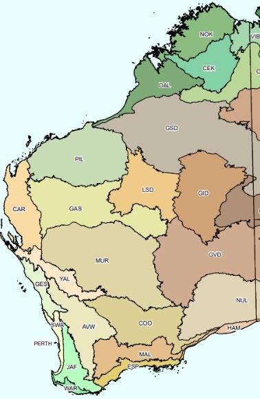
Within the Rangelands region, we have a number of views and separate it into:
The regions has 5 NRM subregions (Figure 2) that are then further separated into Interim Biogeographic Regionalisation for Australia (IBRA) (Figure 3)
• The Plan is available online.
The Regional Plan acts as an investment decision making tool and a framework to guide the development of natural resource management activities for regional, sub regional and local land, coast, and sea managers. The three main objectives of the Plan are:
1. Climate Subclusters 3 subclusters that span from the tropical north to temperate and semi arid south
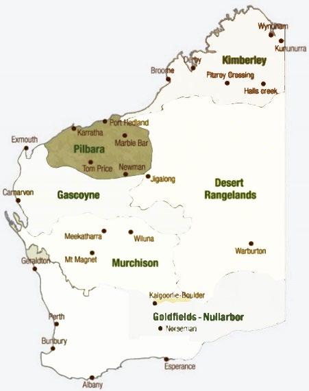
2. Subregions the Kimberley, Pilbara, Desert, Gascoyne, Murchison, and Goldfields Nullarbor
3. To create a plan that is easy to update as new information becomes available
5. Assets
• Outlines the regional and bioregional areas, details the assets and threats to the natural resources for each, and prioritises and recommends options for managing the assets and the threats.
2. To identify specific, well considered investment opportunities that have a high likelihood of success
• Provide prioritisation and options for co design and delivery with the community
The Plan and its supporting documents have a core focus and purpose for the organisation:
4.2 Layers of the Plan
3. Priority Areas incorporating significant assets, manageable threats, and the willingness of community to be engaged, demonstrating strong leadership, and having a sustainable vision for the area
4. Community 22 layers of land managers and stakeholder groupings (8.2.4)
Climate projections are based on the Bureau of Metrology (BOM) ‘subclusters’ (Figure 3), Monsoonal Northwest subcluster includes the Kimberley; Northern Rangelands subcluster contains the Pilbara, and Desert; with the Southern Rangelands subcluster taking in the Murchison, Gascoyne, and Nullarbor Goldfields. Only BoM projections with ‘high’ or ‘very high’ levels of confidence are included.
4.1 Objectives of the Plan
4 Regional Plan 2017 22
V4 Regional Plan 2022 Page 17 of 117
Rangelands NRM does not expect to invest in every asset in the Priority Areas, the Priority Areas provide scope to be selective when choosing preferred projects within the subregions.
The Asset Registers developed for all Rangelands Subregions are located within Section 5
Figure 2. Rangeland Sub regions
4.3 Approach of the Plan
Figure 4 IBRA Bioregions, V 7Figure 3. Sub cluster climatic zones.
To strategically guide investments, Rangelands NRM has identified Priority Areas at the subregional level (Kimberley, Pilbara, Gascoyne, Murchison, Goldfields Nullarbor, and the Desert) to ensure a proactive approach in achieving outcomes which are both realistic and focused. The Priority Areas provide a focus for future investment opportunities, against a backdrop of a dynamic environment with climatic extremes and other drivers


It is recognised that not all the investment funds available for projects will be invested into specific assets; some investments will be made to into human assets to build the skillsets of the land, coast and sea managers, and communities of practice, to deliver catchment wide and cross regional projects.
V4 Regional Plan 2022 Page 18 of 117
The Plan is asset based, meaning that it focuses on specific places in the landscape places that physically exist and can be pinpointed on a map, such as a wetland, an island, a vegetation community, or an animal (or its habitat).
The identified Priority Areas are not in response to any specific funding program, they reflect what is needed in the region to conserve special environmental areas, nurture enthusiasm and involvement of community and address threats affecting environmental assets.
7. Rivers, Lakes, and Wetlands.
framework is an addition to Rangelands NRM’s existing Program and Project Management System (Section 8.3) that captures Monitoring, Evaluation and Reporting information.
V4 Regional Plan 2022 Page 19 of 117
TheNullarbor).developing
Priority Areas have been defined by having umbrella and significant environmental assets, manageable threats, and the willingness of community to collaborate and be engaged, demonstrating strong leadership, and having a sustainable vision for the area.
This will provide a measure and means to evaluate progress against the Plan at the Rangelands regional level and also at sub regional levels (Kimberley; Pilbara; Desert; Gascoyne; Murchison; and Goldfields
Constant co design and community engagement ensures the plan remains current.
Rangelands NRM is developing a framework where this data can be assembled and aggregated against key indicators for the Plan’s 7 Target areas
1. Productive Land Systems;
4.5program.Updating the Plan
6. Flora and Fauna; and
2. Significant Vegetation Ecological Communities;
4. Coastal Zones and Islands;
4.4 Measuring the Success of the Plan
3. Resilient Engaged Communities;
The system records measures of success, key lessons, and opportunities for improvement at a project and program output/outcome scale and for reporting to clients including the Commonwealth’s RLP
5. Threatened Significant Species,
The Plan is reviewed annually and updated as more information comes to hand through proactive regional engagement, nomination of new assets and change in threat status or future projections
5.1 Kimberley Subregion
The Kimberley subregion of the Western Australian Rangelands is 424,517 square kilometres in size and is the State’s most northern Thesubregion.coastline

Figure 5. Kimberly Subregion
arid to semi arid monsoonal climate that is characteristically hot and wet in the summer (wet season) and warm and dry in the winter (dry season). The months of May to August are relatively cool with average temperatures between 16°C and 32°C. In the remaining months maximum temperatures exceed 35°C and in October November often exceed 38°C. Annual average rainfall ranges from 1,500 mm in the north west coastal areas to less than 350 mm on the southern
The major agricultural activities of the Kimberley include horticulture (market g ardening and fruit production), pastoralism and agriculture. Agricultural activities, horticulture and sugar cane provide substantial economic input into the region, especially in the Ord River Irrigation Area (ORIA). Pastoralism is iconic and a way of life in the Kimberley and continues to make a significant contribution to the local economy.NaturalEnvironmentClimateTheKimberleyhasastrongly
5 Subregions

Aboriginal people have inhabited the subregion for at least the past 40,000 years. The Kimberley environment holds great cultural significance for Aboriginal people. The Kimberley was first explored by non indigenous people in the late 1800s and during this time pastoralists from across Australia declared land and started to move cattle into the region.
Today the major towns of the Kimberley are Broome and Kununurra. Broome was initially known for pearling however tourism is currently its major industry, while Kununurra’s economy is driven by a mixture of agriculture, mining, and tourism.
Gold was found in Halls Creek in 1885.
The subregion has a diverse regional economy; mining, tourism, agriculture, aquaculture, fishing, and retail are major contributors to the regions’ economic output.
History and Economy
faces the Indian Ocean to the west, and the Timor Sea to the north. It is bordered by the Pilbara subregion to the south, and the Northern Territory to the east
V4 Regional Plan 2022 Page 20 of 117
Mining is by far the largest revenue earner and exploration activities include searching for diamonds, gold, iron ore, nickel, off shore gas and crude oil. Tourism provides the second greatest contribution to the local economy.
The first stations in the region were settled along the major river systems of the Ord and Fitzroy Rivers.
IBRAgrasses.Subregions
subregion is unique and highly varied. It supports a diverse and spectacular flora of more than 2,000 plant species and the fauna is unique and rich in species diversity, including many threatened and endangered species.
includes over one hundred rivers and many more creeks and streams which flow north or west, forming the Timor Sea drainage division. They exhibit highly seasonal flow conditions as a result of being located at the southern edge of the global monsoon system, where intense and widespread rainfall results in flood flows during summer. The largest river in terms of flow in the Kimberley, and in WA, is the Fitzroy which has floodplains several kilometres wide. The Ord is the second largest river in WA and one of the most well known. Water from the Ord River is used in the economically important Ord River Irrigation Area.
coast is approximately 2,500 kilometres in length and contains more than 2,500 islands. It’s unique from an Australian perspective due to its large tidal range, with a movement of up to 12 metres driving coastal processes. This coast is one of the most contorted of anywhere on the Australian coastline and its geological, biological, and anthropogenic history is unique.
TheRiversKimberley
ThereWetlandsare
VegetationVegetation
Flora and BiodiversityFaunainthis
is generally characterised as tropical savanna, although there is considerable variation throughout, determined by rainfall, topography, and soils. The most extensive vegetation is eucalypt woodland and open woodland, but there are also areas of hummock grassland, tussock grassland and acacia open woodland. The ground layer is almost always dominated by grasses, with grazing mostly based on native, perennial tussock grasses and in some instances introduced buffel and birdwood
23 wetlands (including rivers) of national importance and four Ramsar listed wetlands within the Kimberley and nine on the Register of National Estate. The four declared Ramsar sites (listed as International wetlands of significance under a global treaty) in the Kimberley are Lake Kununurra and Lake Argyle, the Ord River Floodplain, Roebuck Bay, and Eighty Mile Beach. Paruku (Lake Gregory) also satisfies criteria for listing as a Ramsar site.
TheCoastlineKimberley
perimeter and is generally confined to the six month ‘wet’ period November to April, with January and February being the wettest months. It has a pronounced north south rainfall gradient, so that southern parts of the zone are semi arid, with a shorter growing season, less reliable rainfall, and higher annual temperature range than the northern parts.
V4 Regional Plan 2022 Page 21 of 117
The Kimberley contains five IBRA sub regions: Central Kimberley, Dampierland, Northern Kimberley, Ord Victoria Plains and Victoria Bonaparte.
5.1.1 Threats to Target Areas
V4 Regional Plan 2022 Page 22 of 117
Threats to target areas in the Kimberley Region are presented below overlain with RLP program activities and identification of new threat/targets under review.
To read more about IBRA subregions, and to access the Australian Government’s detailed descriptions of each, visit the Department of Climate Change, Energy, the Environment and Water website
V4 Regional Plan 2022 Page 23 of 117 Productive Land Systems Significant Vegatation ologicalEc Communities ofSites Significance Resilience Engaged Communities zonesCoastal Islandsand &Threatened Significant peciess Fauna)(Flora/ Lakes,Rivers, Wetlands Summary RatingThreat Climatic SummaryPollutionMining,LandInappropriateintrusionsSaltwaterDisconnection(Predators)Feral(Herbivores)FeralWeedsmanagementInappropriatevisitationInappropriatehyextraction/diversion/WaterInappropriatechangeFiredrationtourism/grazingAnimalsAnimalsandsalinefishingClearingIndustryandTargetRating RLP 2017-23 program/ project Kimberley Region Threats under review Targets Threats HIGH LOWMEDIUMHIGH HIGH HIGHMEDIUM MEDIUM MEDIUM MEDIUM LOW LOWMEDIUM LOWMEDIUM MEDIUM MEDIUM MEDIUMMEDIUMLOW LOW MEDIUMMEDIUMMEDIUMMEDIUMLOW HIGHLOWLOWLOWLOW MEDIUMMEDIUM MEDIUMMEDIUM LOWLOW LOWLOWLOW HIGH LOW LOW LOW LOW LOW LOW LOW LOW LOWLOWLOWLOWMEDIUMLOW MEDIUM MEDIUM MEDIUM HIGH MEDIUMMEDIUM LOW LOW LOW LOWLOWLOW HIGH MEDIUM MEDIUM MEDIUMMEDIUMMEDIUM LOW LOW MEDIUM LOW MEDIUM LOW LOW LOW LOW LOW LOW LOWLOW LOW LOW LOW LOW LOW LOW MEDIUM LOW LOW MEDIUMLOW LOW LOW LOW RLPRLP RLP RLP RLP RLP RLP RLP RLP RLP RLP RLP RLP RLPRLP RLP RLP RLP RLP LOW RLP RLP RLP
V4 Regional Plan 2022 Page 24 of 117 5.1.2 Kimberley Asset Register KIMBERLEY ASSETS NumberUMBRELLA Name Project Number Name Project B014 Buccaneer Archipelago (Sunday Island Group) Sunday Straight B012 Canning Basin (Timor Basin) K056 Critical Weight Range mammal community - Carson River to Yampi Military Land B019 Critical Weight Range mammal community - North Kimberley above 1000mm rainfall B023 Dampier Peninsula - West Coast K015 Eighty (80) Mile Beach (inc: Migratory shorebirds, Bilby, ramsar areas and turtle nesting areas) RLP B036 Fitzroy River (Mardoowarra) Entire system K036 Highly productive pastoral land in the Kimberley RLP K032 Lake Argyle D008 Lake Gregory (Paraku) inc migratory shorebirds K022 Lake Kununurra K060 North Kimberley and Camd en Sound Marine Parks B053 North Kimberley IBRA region RLP K083 North Kimberley offshore islands (31 islands) K035 Ord River - Entire catchment B002 Perennial Savannah Grasslands RLP K017 Purnululu NP / Bungle Bungles B071 Rainforest in the Kimberley B018 Riparian Vegetation Community B040 Roebuck Bay - Entire B003 Savannah woodland RLP F002SIGNIFICANTAlexander Island B034 Byal Byal Freshwater sawfish B073 Cable Beach RLP B022 Camballan Wetlands K025 Cape Domett turtle nesting beach B027 Carnot Peaks and Kings Peak K053 Central Gibb River Road gorges (eg Manning, Adcock Moll) F004 Christmas Creek B054 Coastal reserves including Kennedy Hill K034 Cockburn Ranges K055 Critical Weight Range mammal community - Charnley River, Artesian Range (ex Beverley Spring Station) K054 Critical Weight Range Mammal community - Mornington & Tablelands Stations F017 Cycads (Ridge loving Cycads on Fairfield Station) B032 Dampier Peninsula - Gouldian Finch B038 Dampier Peninsula Greater Bilby Population RLP B024 Dampier Peninsula Monsoon Vine Thicket on Coastal Sands TEC RLP B037 Dampier Peninsula - Seagrass meadows K024 Dampier Peninsula - Water Resource F001 Devonian Reef D041 Dragon Tree Soak Nature Reserve B031 Edgar Ranges B044 Fitzroy River- Lower reaches K018 Fitzroy River- Water Resource (industry groundwater in lower reaches) F007 Fossil Soil Type B004 Frazier Downs Coastal Strip K020 Geikie Gorge
V4 Regional Plan 2022 Page 25 of 117 K027 Gouldian finch populations of Wyndham and Ord Stage 2. B021 Gourdan Bay B067 Humpback whale calving grounds K082 Lake Gladstone B039 Lake Louisa B069 Lake Patterson F009 Lakes on Bulka Station B029 Lolly Well Springs and Bobbys Creek D038 Mandora Marsh K037 Mirruiwung Gajerrong DEC reserve F008 Mitchell and Flinders Grasslands pastoral grazing land B001 Munkayarra Wetland D045 Munro Spring water and animal places B072 Nimalaica wetland near Willie Creek K039 Ord River - Ramsar site including associated land system (inc: Lake Kununurra – Ramsar site and high value conservation areas) K023 Ord River- the lower part of the system K059 Ord River - Water Resource (quantity) K057 Ord River Irrigation Area (ORIA) B056 P1 Public Drinking water soruce Area D004 Paruka Indigenous Protected Area (wetland complex) B068 Pender Bay including Pender Gardens outstation B035 Atlas Moth Plant -Pittosporum moluccanum K031 Rainforest, North Kimberley, particularly on Bougainville Peninsula B049 Roebuck Bay- Faunal Values B051 Roebuc k Bay- Fish Stocks B048 Roebuck Bay- Intertidal mudflats B052 Roebuck Bay- Migratory shorebirds RLP B045 Roebuck Bay- Seagrass meadows RLP B041 Roebuck Plains Lakes/wetlands chain RLP D047 Salt Creek B017 Sandstone Ridges (Heath vegetation community) B064 Scaly tailed Possum and Rock Ringtail B063 Sea Turtles- Across the region RLP B046 Small mammals (Golden back tree rat and Golden Bandicoot [Dampier Peninsula] and Dunnarts) RLP F006 Spectacle Hare Wallaby RLP B030 TECs and PECs in Broome Peninsula and Dampier Peninsula B061 Tropical rangelands K019 Tunnel Creek B020 Udialla Springs (Pastoral Lease) (Oongalkakda) B065 Vine thickets of the north and central Kimberley RLP D046 Wetlands of the Great Sandy Desert K021 Wild rivers in the Kimberley B043 Willie Creek wetlands (Nimalarragun) B028 Yalleroo Lakes B025 Yarp Lake System TBA Night Parrot RLP TBA Bilby - macrotis lagotis RLP TBA Purple Crowned fairy wren TBA Black flanked rock wallaby RLP TBA Northern Quoll RLP K073NOTABLE Annie Creek K075 Artesian Range B008 Beagle Bay B007 Camballin Barrage Pool K079 Chamberlain River Valley F019 Clay Soil Types
• The threat of woody thickening will continue to be monitored (especially in the north of the subregion)
Key features and issues of the Kimberley Subregion are:
• Fire management is increasingly important. Late dry season fires tend to homogenise the vegetation structure, with mid storey vegetation particularly at risk. They also contribute significantly to greenhouse gas emissions, with the savannah burning carbon method increasingly providing additional cost sharing and incentives. These fires also contribute significantly to greenhouse gas emissions.
• Increasing need for cross tenure collaborations between pastoral, cultural and conservation land managers.
• A small proportion of the subregion is within the conservation estate (recently increased).
• In the recent past a long run of good to very good rainfall years produced the best sequence of rainfall on record, even better than the mid 1970s and the period leading up to the 1920s.
5.1.3 Key management issues and features of the Kimberley Subregion
• Mean sea level will continue to rise and height of extreme sea level events will also increase.
• Increased intensity of extreme rainfall events is projected.
V4 Regional Plan 2022 Page 26 of 117 B042 Coastal camping spots/ free camping B070 Cypress Pine, Mt Elizabeth Station B026 Dampier Peninsula - Inshore dolphins K077 Fitzroy River- on Mornington Station F003 Fitzroy River (Mardoowarra) - Fitzroy crossing town area and old crossing B016 Lake Eda and other lake and wetlands systems on Roebuck Station. B015 Lower Liveringa (Water reserve) K074 Marion Downs spring fed wetlands B050 May River (crossing) 3Desktop Minyirr Park Coastal Reserve K076 Mornington destocked area B066 Myroodah Crossing F050 Nippa Dam (mountains around) K030 Nulla Nulla D049 Pepperpot Springs K080 Phillips Range (Northern Brown Bandicoot) B047 Roebuck Bay & Willie Creek- Mangroves K078 Sir John Gorge (Northern Quolls and Short eared Rock wallabies) F033 Solloman Creek Rock Hide D048 Walyarta Salt Creek (Mandora Mash) K052 Wood River/ Rust Range Proposed Conservation Estate Assets included under 2022 Review
• Infrastructure development has made more pastoral land accessible to livestock and raised the potential for increased livestock numbers.
• Basic management is still largely ‘cattle harvesting’ with minimal fences and mostly natural waters (especially in the north of the subregion).
• More hot days and warm spells are projected to increase with average temperatures continuing to increase in all seasons.
• Included in the subregion are the expanded stage 2 and 3 of the Ord River irrigation area. This will further increase irrigated agriculture, and some pastoral leasehold land will be resumed for this purpose.
Figure 6. Pilbara Subregion
• Biosecurity issues abound, including recent arrival of Myrtle Rust fungal pathogen Austropuccinia psidii
History and Economy
• Weed infestation remains an on going risk, with the Northern Kimberley the most weed free area
• Income from tourism provides a substantial proportion of pastoralists’ livelihood (especially in the north of the subregion).
• Cane toads threaten the enter subregion having penetrated from Northern Territory over the last decade to the central Kimberley.
It is bordered by the Gascoyne subregion in the south, the Kimberley subregion in the North, the Indian Ocean to the west and the Desert Rangelands to the east.

The main economic activities of the region include mining, petroleum, pastoralism, and tourism.
Today the major towns of the Pilbara are Karratha, Roebourne, Onlsow, Port Hedland, South Hedland, Newman, Pannawonica, and Tom Price.
V4 Regional Plan 2022 Page 27 of 117
• More than 5% of the subregion is within the conservation estate.
Some of the most significant mineral resources being mined in this region are iron ore, salt, molybdenum, manganese, gold, copper, tantalite, silver, lead and zinc. A significant portion of the Pilbara is under mining tenement although only a small portion is directly subjected to exploration and mining activities. Currently more than 95% of Australia’s iron ore exports come from the Pilbara. The Pilbara has the largest solar salt fields in Australia and the second largest in the world. As well this subregion has a large proportion of Australia’s hydrocarbon reserves making it the major gas processing hub of the nation. The Pilbara also produces oil and gas products such as fertiliser and industrial products such as those from the world’s largest ammonia plant, opened on the Burrup Peninsula in April 2006.
Aboriginal people have lived in the Pilbara for more than 40,000 years and the many different indigenous groups of the region call it Bilybarra, which means ‘dry country’. In 1818, Captain Philip Parker King arrived in the Dampier Archipelago, he was later followed by Francis Thomas Gregory who arrived in 1861 at Nickol Bay on the ‘Dolphin’. Francis Thomas Gregory named Hearson’s Cove, the Maitland and Fortescue rivers, the Hamersley Ranges, and Mt Samson and Mt Bruce.
5.2 Pilbara Subregion
The Pilbara subregion of the Western Australian Rangelands covers an area larger than 500,000 square kilometres and has about 4,665 kilometres of coastline.
The majority of the subregion (58 per cent) is under pastoral leasehold tenure, with leases being between 200,000 and 300,000 hectares, although smaller on the more productive coastal areas. Before the economy boom in the 1960s, pastoralism was the main industry in the Pilbara, this was until settlers realised that the environmental conditions of the region were generally unfavourable for crops.
river systems of the Pilbara are the Fortescue System, and the De Grey and lesser rivers off the Northern divide of the Chichester Range. Along many of the region’s rivers e.g. the Fortescue and Oakover rivers, rock holes, gorges, grassy floodplains and wooded riparian areas occur. Intermittent systems like the Fortescue and Oakover rivers drain the Hamersley Ranges, the largest mountain range in Western Australia.
SixWetlandsPilbara
TheRiversmajor
TheClimatePilbara
wetlands have been identified as being of national significance, including Fortescue Marsh, Millstream Pools, Karijini Gorges, Leslie Saltfields system, De Grey River, and the Mt Bruce coolibah lignum flats. A further 12 have been identified as being of regional significance. There is one Ramsar listed wetland site, located on the very southern edge of Eighty Mile Beach.
has a semi arid to arid climate that is characterised by high temperatures, low and variable rainfall, and high evaporation. Between the months of October and April temperatures exceed or reach 32°C almost every day and the average maximum temperature is often over 40°C. In the winter months the average temperature falls to 25°C. Inland the temperatures are generally higher due to the absence of a cooling sea breeze.
The average annual rainfall of the Pilbara subregion ranges from about 200 to 350 mm per year, however, the rainfall can vary widely from year to year. Most of the rain falls in the summer months between December and March but can continue through until June. This is followed by a pronounced dry period between August and November. The average yearly evaporation is about 2,500 mm; this exceeds the average yearly rainfall and is consistent throughout the year.
The Pilbara is valued by the tourists for the variety of recreational experiences, wilderness experiences and scenic views it provides. Key draw cards are the region’s natural assets e.g. Karijini and Millstream Chichester National Parks.
Natural Environment
The coast from Port Hedland to Exmouth Gulf is the most cyclone prone area in Australia, with three to four tropical cyclones expected every year.
TheCoastlinePilbara
coastline is characterised by deltas like the De Grey River delta, barrier islands and lagoons with extensive mangroves, wide tidal mudflats like the Roebourne Plains and long stretches of sandy beaches or rocky shorelines.
V4 Regional Plan 2022 Page 28 of 117
Flora and Fauna
The Dampier Archipelago has pristine reefs with islands that are virtually untouched. Some of the marine areas within the region, like the Dampier Archipelago, are considered to be the most biologically diverse in the state.
IBRA Subregions
5.2.1 Threats to Target Areas
and shrubs are found widely throughout the Pilbara subregion. Hummock grasslands are the most extensive vegetation type; as well there are significant areas of tussock grassland, acacia woodland and open woodland. Smaller areas of chenopod shrubland and eucalypt woodland occur primarily on floodplains and along drainage lines. The coastal strip consists of grasslands and low open woodlands and th e coastal flats have mangroves scrub.
To read more about IBRA subregions, and to access the Australian Government’s detailed descriptions of each, visit the Department of Climate Change, Energy, the Environment and Water website
The Pilbara contains known aquifers that support endemic stygofauna.
Threats to target areas in the Pilbara Region are presented below overlain with RLP program activities and identification of new threat/targets under review.
The Department of Environment and Heritage identified the Hamersley Pilbara area as one of the 15 biodiversity hotspots of Australia. This region provides habitat for a number of threatened, endemic and fire sensitive species and communities e.g. the ghost bat, mulgara and spectacled hare wallaby.
AridVegetationgrasses
The Pilbara contains one IBRA sub region, named Pilbara.
V4 Regional Plan 2022 Page 29 of 117
V4 Regional Plan 2022 Page 30 of 117 Productive Land Systems Significant Vegatation ologicalEc Communities ofSites Significance Resilience Engaged Communities zonesCoastal Islandsand &Threatened Significant peciess Fauna)(Flora/ Lakes,Rivers, Wetlands Summary RatingThreat Climatic SummaryPollutionMining,LandInappropriateintrusionsSaltwaterDisconnection(Predators)Feral(Herbivores)FeralWeedsmanagementInappropriatevisitationInappropriatehyextraction/diversion/WaterInappropriatechangeFiredrationtourism/grazingAnimalsAnimalsandsalinefishingClearingIndustryandTargetRating RLP 2017-23 program/ project Pilbara Region Threats under review Targets Threats HIGH HIGH HIGH HIGH HIGH HIGH HIGH HIGH MEDIUM MEDIUM MEDIUM MEDIUM MEDIUM MEDIUM MEDIUM MEDIUM MEDIUM MEDIUM MEDIUM MEDIUM MEDIUM MEDIUMMEDIUMMEDIUM MEDIUMMEDIUM MEDIUM MEDIUM MEDIUM MEDIUMMEDIUMMEDIUMMEDIUMMEDIUMMEDIUM MEDIUM MEDIUM LOWLOW LOW LOW LOW LOW LOWLOWLOWLOW LOW LOWLOWLOW LOW LOW LOW LOW LOW LOW LOW LOWLOWLOW LOWLOWLOW LOWMEDIUMLOWLOW MEDIUMLOW MEDIUMLOW MEDIUMLOW MEDIUMLOW MEDIUMLOW MEDIUMMEDIUMLOWLOWMEDIUMLOWMEDIUMLOWMEDIUMLOW MEDIUMLOW MEDIUMLOW MEDIUMLOW MEDIUMMEDIUMMEDIUMLOW MEDIUM MEDIUMMEDIUM MEDIUMMEDIUMMEDIUMMEDIUM MEDIUM MEDIUM MEDIUM RLP RLP RLPRLP RLP RLP RLP RLP
V4 Regional Plan 2022 Page 31 of 117 5.2.2 Pilbara Asset Register PILBARA ASSETS NumberUMBRELLA Name Project Number Name Project Desktop 6 Burrup Peninsula KA069 Dampier Archipelago Desktop 4 De Grey River KA021 Fortescue Marsh - Entire KA035 Fortescue River Desktop 5 Hamersley Range Desktop 7 Millstream Chichester National Park KA004 Pilbara offshore islands (excluding Barrow Island) KA046 Pilbara Sand Cays Onslow to Dampier excl Dampier Archipelago KA062SIGNIFICANT Arid zone mangroves Desktop 23 Barrow Island group Nature Reserve KA027 Blind Cave Eel KA014 Bungaroo Valley aquifer T029 Cane River KA020 Caves Creek KA022 Coondewanna Flats Priority Ecological Community KA031 Coral (inshore coastal strip Onslow to 80 mile beach) KA017 Deep Gorge KA010 Ephemeral wetlands of Nickol bay remnant dune and Burrup Peninsula KA026 Ethel Gorge KA040 Fish resource (inshore coastal) KA032 Flatback Turtles at Port Hedland RLP T025 Fortescue freshwater claypans downstream of the Marsh Desktop 8 Fortescue Marsh Floodplain KA065 Grazing Rangelands RLP KA034 Intertidal and supratidal habitat (Dampier salina) T021 Karijini Gorges Desktop 9 Karijini National Park KA070 Karrawine Gorge (Oakover River) KA049 Limestone Islands Desktop 18 Lowendal Islands Nature Reserve KA036 Marine mangroves KA025 Millstream wetland KA005 Montebello Islands T020 Mount Meharry KA045 Mountain top flora (uplands of the Hamersley Ranges) KA030 Mulga lands ConservationproposedPark KA023 Munjina Claypan T007 Native grasses/grasslandsperennial T030 Peedamulla wetlands and swamp KA018 Pilbara leaf nose bat at API cave KA003 Rock art - Burrup Peninsula KA008 Rock art various locations, excluding Burrup Peninsula KA006 Roebourne Plains RLP KA024 Sand d unes of Fortescue Valley KA064 Sea grasses inshore coastal strip KA019 Skull Spring (upper Oakover, De Grey River) T001 Springs on Cheela Plains KA060 Themeda grasslands (Hamersley Station) T011 Upper Yule River catchment T026 Weeli Wolli pools - example of pastoral lease reform T002 Weeli Wolli Spring KA013 West Mid Intercourse Island KA002 White Sandy Dunes (on soils dataset) KA050 Wonna Land System TBA Northern Quoll TBA Greater Bilby RLP TBA Night Parrot RLP NOTABLE
• Stocking rates have increased considerably since the early 1990s.
• About 8.3% of the bioregion is within the conservation estate.
• Mean sea level will continue to rise and height of extreme sea-level events will also increase
• Average temperatures will continue to increase in all seasons and more hot days and warm spells are projected.
Pastoral Land on Mardie and Yarraloola stations KA041 Pastoral rangeland on Mt Florence Station (watershed of the Hamersley)
KA047 of Pilbara
T003
KA051
Leeuwen’s Wattle - Acacia leeuwinana KA039 Air Quality- Port Hedland and Dampier Desktop 11 Barramundi T006 Beasley River T028 Bush Tucker and medicine plants T005 Catchment areas e.g Turner syncline (Rocklea Dome)
KA012
Subregion
Key features and issues of the Pilbara Subregion are:
• There is also high confidence of increase in the intensity of extreme rainfalls events, with low pressure cyclonic cells penetrating further and more frequently into the Pilbara (and Deserts)
Cleaverville turtle nesting sites T022 Fortescue Marsh Floodplain in Marillana station RLP
V4 Regional Plan 2022 Page 32 of 117
the
KA016
• Wild dog numbers and their impacts have increased markedly in recent years.
KA011
Fortescue River Floodplain on Mt Florance Station T004 George River- estuary/river mouth
Isolated landforms e.g. Mount Robinson The Governor KA028 Hamersley - Lepidium catapyncon
• Camel populations continue to encroach from desert areas in the east of the bioregion, with joint desert pastoral interface partnerships fluctuating.
• Mesquite and Parkinsonia weeds in the western part of the bioregion, and upper catchments of the rivers. Despite significant resources going into management, the problem remains out of control.
KA048
• About 15% of the pastoral leases are under Indigenous ownership and another 15% are under mining company ownership.
• Infrastructure development has made more pastoral land accessible to livestock and raised the potential for increased livestock numbers.
Maitland River KA015 Meentheena T008 Minor inland rivers KA029 Mulgara RLP T031 Native Perennial grasses on Cheela Station RLP KA042 Natural structures that slow water within drainage channels
Rare Flora (Declared Rare Flora, Priority Flora, EPBC listed flora) T024 Riparian corridors between Karijini and Newman Desktop 10 Rocklea Dome T027 Running waters pool and spring T023 Springs and semi permanent waterholes between Karijini and Newman KA043 Steep slopes at top/edge of catchment KA063 Tichella / Condon beaches and estuaries KA052 Western Turner River Assets included under 2022 Review 5.2.3 Key management issues and features
In 1818 Lieutenant Phillip Arthur King completed a survey of the Exmouth Gulf. In 1839 the British explorer Lieutenant George Grey and his party, came across Bernier Island (approximately 48.3 km west of Carnarvon) and the Gascoyne River for the first time, however there was little settlement until the 1890s Murchison gold rushes. Early pastoral settlements were focused along and around the major water courses. During this period the Aboriginals were forced away from their traditional ceremonial and hunting sites. This resulted in tribal disintegration and caused fragmented family groups to adapt their lifestyle and congregate on pastoral properties. The Aboriginal people were highly valued and respected workers and were considered to be the backbone of the cattle industry.
In the 1930s orchards were established, the Gascoyne River bridge was built and there was a prosperous sheep industry.
The Gascoyne subregion was home to Aboriginal people for thousands of years before it was discovered by Europeans. There are many key cultural and sacred sites throughout the subregion that provide significant insight into the rich heritage of Aboriginal history. This includes Shark Bay (a national heritage listed area); Mt Augustus and Wilgie Mia, the world’s oldest ochre mine, just to name a few.
V4 Regional Plan 2022 Page 33 of 117
is the dominant land use in the Gascoyne. Lease sizes are typically between 100,000 and 250,000 hectares.
The regions horticultural crops include bananas, tomatoes, grapefruit, mangos, table grapes and a range of vegetables products grown along the Gascoyne River.
5.3 Gascoyne Subregion
Today the major towns of the Gascoyne are Carnarvon, Exmouth, Denham, Gascoyne Junction, Burringurrah Community and Coral Bay.
Figure 7. Gascoyne Subregion

The main economic activities of the region include pastoralism, horticulture, retail, tourism, mining , and Pastoralismfishing.
The fishing industry of the Gascoyne is based in Carnarvon and Exmouth and includes prawn, scallop, crab, and wet line fishing operations.
The Gascoyne subregion of the Western Australian Rangelands covers an area of approximately 264,497 square kilometres.

It is bordered by the Murchison subregion in the south, the Pilbara subregion in the North, the Indian Ocean to the west and the Desert subregion to the east.
Mining operations include salt and gypsum mining; these are mined at Lake MacLeod, north of Carnarvon.
History and Economy
Natural Environment
Wetlands of national significance in the Gascoyne region are Cape Range Subterranean Waterways (including the associated karst system), Exmouth Gulf east, Lake Macleod and the McNeil Claypan System. The northern end of Lake Macleod has been proposed for listing as a wetland of international significance under the Ramsar agreement.
TheCoastlineGascoyne
of the Gascoyne are ephemeral, meaning the rivers dry up for at least part of the year. The western half of this region is dominated by the catchment areas of the Ashburton and Gascoyne Rivers. The Gascoyne River Basin has a total area of approximately 77,600 km2 and discharges into the ocean at Carnarvon. Tributaries of the Gascoyne River include Lyons River, Turner Creek, Thomas River, Dalgety Brook. The Lyndon and Minilya Rivers are two relatively small rivers originating in the inland rangelands and discharging into Lake Macleod, a wetland of national significance.WetlandsAlthoughmuch of the subregion’s surface water is ephemeral, there are a number of permanent pools and soaks that survive the summer as wetlands.
V4 Regional Plan 2022 Page 34 of 117
coastline can be broken up into three broad areas; the Shark Bay Area in the south, the Ningaloo Coast and Exmouth Gulf in the north and the Quobba Coast in between. Shark Bay is
The average annual rainfall of the Gascoyne is between 190 mm to 250 mm and is relatively uniform throughout most of the region; however, it is highly variable particularly in the central and eastern parts. Most of the rainfall occurs in two ‘seasons’ January to March and May to July. Summer rainfall is less reliable than the May to July rainfall, but it can be very significant especially when it is produced by tropical lows and cyclones.
of the Gascoyne is semi arid to arid, with hot summers and mild winters. Temperatures are highest between January and February, during this time inland average temperatures generally exceed 37°C. Due to sea breezes, coastal temperatures are kept well below those inland. Average winter temperatures range below 18°C in the far south to 23°C in the North. In July the overnight minimum averages about 10°C in coastal area’s and 6°C in the far east.
TheClimateclimate
Wetlands of regional significance within river systems of the subregion include Cattle Pool and Edithana Pool (Lyons River), Rocky Pool, Fishy Pool, Erong Spring, Mibbley Pool, Yinnitharra Cattle Pool and Mooka Springs (Kennedy Ranges) (all part of the Gascoyne River system) and Callytharra Spring (Wooramel River).
Due to the warm climate and long coastline, which includes Ningaloo Coast and Shark Bay World Heritage Areas, tourism is an important industry in the Gascoyne subregion.
TheRiverswatercourses
V4 Regional Plan 2022 Page 35 of 117
IBRA Subregions
Australia’s largest enclosed marine embayment and Ningaloo Reef is Australia’s only fringing coral Florareef. and Fauna
The biodiversity of the Gascoyne is rich and varied across extensive terrestrial ecosystems. The region also has an exceptional marine and coastal zone which includes the Ningaloo fringing reef and parts of the Shark Bay World Heritage Area.
VegetationVegetation
of the Gascoyne is predominantly chenopod and Acacia shrublands and woodlands, however many other vegetation types can be found within this region. Much of the Gascoyne region can be described as the ‘mulga zone’. The natural vegetation of this region consists of Spinifex (Triodia), Wattle (Acacia) and Poverty Bush (Eremophila) shrub varieties.
Along the subregion’s rivers and adjacent floodplains a number of eucalypt varieties grow along with Paperbarks (Cadjeputs). On the alluvial flats shrubs of Bluebush (Maireana) and Saltbush (Atriplex) species are present. In coastal areas Mangroves grow. The hardpan plains support open mulga woodlands and scrub, the ranges are dominated by Eremophila shrublands and the salt lakes are characterised by succulent steppes.
The Gascoyne contains two IBRA sub regions: Carnarvon and Gascoyne.
To read more about IBRA subregions, and to access the Australian Government’s detailed descriptions of each, visit the Department of Climate Change, Energy, the Environment and Water website
5.3.1 Threats to Target Areas
Threats to target areas in the Gascoyne Region are presented below overlain with RLP program activities and identification of potential new threat/targets under review.
V4 Regional Plan 2022 Page 36 of 117 Productive Land Systems Significant Vegatation Ecological Communities ofSites Significance Resilience Engaged Communities zonesCoastal Islandsand &Threatened Significant species Fauna)(Flora/ Lakes,Rivers, Wetlands Summary RatingThreat Climatic SummaryPollutionMining,LandInappropriateintrusionsSaltwaterDisconnection(Predators)Feral(Herbivores)FeralWeedsmanagementInappropriatevisitationInappropriatehydrationextraction/diversion/WaterInappropriatechangeFiretourism/grazingAnimalsAnimalsandsalinefishingClearingIndustryandTargetRating RLP 2017-23 program/ project Gascoyne Region Threats under review Targets Threats MEDIUMMEDIUMMEDIUMMEDIUMLOWMEDIUMHIGHHIGHHIGHHIGH MEDIUMLOWMEDIUMLOWMEDIUMLOWMEDIUMLOW MEDIUMLOW MEDIUMLOW MEDIUMLOW MEDIUMLOW MEDIUMMEDIUMLOWLOWMEDIUMLOWMEDIUMMEDIUMLOWMEDIUMMEDIUMMEDIUMLOW MEDIUMLOW MEDIUMLOW MEDIUMLOW MEDIUMLOW MEDIUMLOW MEDIUMLOW MEDIUMLOW MEDIUMLOW MEDIUMLOW MEDIUMLOW MEDIUM MEDIUMMEDIUMLOWLOWMEDIUMLOWMEDIUMLOWMEDIUMLOWMEDIUMLOWMEDIUMLOW MEDIUMLOWMEDIUMLOWMEDIUMLOWMEDIUMMEDIUMLOWLOW MEDIUMLOW MEDIUMLOWMEDIUMLOWMEDIUMLOWMEDIUMLOW MEDIUMLOW MEDIUMLOWMEDIUMLOWMEDIUMLOWMEDIUMMEDIUMLOWLOWMEDIUMHIGHHIGH MEDIUMMEDIUM MEDIUMMEDIUM MEDIUMMEDIUM MEDIUMMEDIUM MEDIUMMEDIUM MEDIUMMEDIUM MEDIUMMEDIUM MEDIUMMEDIUM MEDIUMMEDIUM MEDIUM MEDIUMMEDIUM MEDIUMMEDIUM MEDIUMMEDIUM MEDIUMMEDIUM MEDIUMMEDIUM MEDIUMMEDIUM MEDIUMMEDIUM MEDIUM MEDIUMMEDIUM HIGHMEDIUMMEDIUMLOWLOWLOW MEDIUM MEDIUMLOWLOW MEDIUM MEDIUM MEDIUM RLP RLP RLP RLP RLP RLP RLP RLPRLP
V4 Regional Plan 2022 Page 37 of 117 5.3.2 Gascoyne Asset Register GASCOYNE ASSETS NumbeUMBRELLAr Name Project Number Name Project G002 Gascoyne River RLP Desktop 13 Islands off the North West Cape C008 Ningaloo Reef RLP Desktop 14 Shark Bay- Peninsulas and islands Desktop 40 Shark Bay Marine Park (East Shark Bay) RLP Desktop 41 Wooramel River channel and floodplains C011SIGNIFICANT Barlee Range reserve (Jidarda) C038 Bernier and Dorrie Islands Desktop 24 Bottomland systemsGascoyne Desktop 16 Carnarvon Coastal Plain landsystems RLP C024 Carnarvon horticulture precinct C005 Chaffcutters and associated springs C014 Chenopod shrublands at Lake MacLeod G016 Cobra Valley C037 Dugong C022 Eastern escarpment of Kennedy Range National Park Desktop 22 Exmouth Gulf- Entire Desktop 19 Exmouth Gulf Islands Nature Reserves G018 Gascoyne Floodplains RLP C023 Gascoyne River Aquifers (Carnarvon) C031 Gascoyne River mouth Desktop 17 Karst System of Cape Range Desktop 20 Lake Macleod - Entire C001 Lake Macleod - Northern ponds G013 Lorna Glen and Earaheedy Reserves G014 Lower Ashburton floodplains and coastal area G023 Lower Lyons River C004 Mooka Spring G019 Mount Augustus Entire Desktop 21 Northwest Cape Karst fauna G012 Palatji "Weld Spring" C036 Sea Turtles RLP G008 Seeps and springs at the base of Mt Augustus G001 Upper Lyons River C002 Wirrawaana (Dirk Hartog Island) TBA Night Parrot RLP TBA Mallefowl Leipoa ocellata RLP TBA Hamelin Pool Stromatolites RLP TBA Wooramel seagrass bank RLP G003NOTABLE Ashburton River Desktop 26 Birdrong Aquifer C032 Browera Flats Desktop 29 Calcreted valley fill and dolomitic areas (carbonate rocks) Desktop 38 Callytharra Springs area G009 Cattle Pool G004 Dingo Gap G005 Edithana Pool C012 Fishy Pool C035 Fresh water seeps in frontal dune troughs C006 Gladstone G007 Kurrabuka Creek C007 Mangroves on the Wooramal Coast C010 Mc Neill's Claypan G006 Mt James area G020 Old Cobra, original homestead
• Low proportion (<10%) of pastoral leases are under mining company ownership.
• Mean sea level will continue to rise and height of extreme sea level events will also increase
For thousands of years the Murchison has been home to many different Indigenous groups. These groups are collectively known as the Yamatji People. Much of the traditional customs and knowledge of the Yamatji People has been lost as a result of dispossession of their homelands. The culture of the Yamatji People has been slowly eroded by the dominance of the western culture, however, the spirit and identity of these people still remains very
• Winter rainfall is projected to decrease but an increase in intensity of extreme rainfall events is projected.
• More hot days and warm spells are projected, and average temperature will continue to increase in all seasons, with future harsher fire weather conditions.
Instrong.theearly
• Historical trend in enterprise type away from merino sheep to cattle and meat sheep
5.3.3 Key management issues and features in the Gascoyne Subregion
1800s European exploration and settlement of the subregion began. On his voyage to the Shark Bay region and subsequent journey to Perth, Lieutenant George Gray named and explored many
V4 Regional Plan 2022 Page 38 of 117 C013 One Mile Jetty Inner Mangrove s System G017 Peedawarra Flats land system G021 Pingandy Creek catchment G011 Quandong C009 Rocky Pool G010 Rufous Hare Wallaby and Western Barred Bandicoot RLP G015 Savory Creek- Headwaters Desktop 28 Shark Bay- Birrida pans on peninsulas (salt lakes) C003 The Blowholes G022 "The Lake" on Mt Augustus Station
The Murchison subregion of the Western Australian Rangelands covers an area of approximately 331,775 square
Itkilometres.isbordered
5.4 Murchison Subregion
by the South West Region and Goldfields subregion in the south, the Gascoyne subregion in the North, the Indian Ocean to the west and the Desert Rangelands to the east.History and Economy

Figure 8. Murchison Subregion
• Low proportion (<10%) of pastoral leases are under Indigenous ownership.
Key features and issues of the Gascoyne Subregion are:
of the coastal geographical features. By the 1850s pastoralism, agriculture and mining industries had begun to establish. In the late 1880s gold prospectors sought fortune in the Murchison gold rushes.
area of coastline in the Murchison subregion is the Shark Bay World Heritage Area. The Shark Bay World Heritage Area is Australia’s largest enclosed marine embayment. It covers an area more than 2.2 million hectares and has a coastline greater than 1,500 km long.
Today the major towns of the Murchison are Leinster, Leonora, Meekatharra, Mount Magnet, Laverton, Cue and Wiluna.
The main economic activities of the region include mining , agriculture, fishing, and tourism.
much of the subregion’s surface water is ephemeral, there are a number of permanent pools and soaks that survive the summer as wetlands. Wetlands of national significance in the Murchison subregion are Hamelin Pool, Murchison River (lower reaches), Anneen Lake (Lake Nannine), Breberle Lake, Lake Ballard, Lake Barlee, Lake Marmion, and Wooleen Lake.
TheClimateclimate
of the Murchison are ephemeral, meaning the rivers dry up for at least part of the year. The major catchment of the region is the Murchison River catchment. The Murchison River Basin has a total area of approximately 91,000 km2 and discharges into the Indian Ocean at Kalbarri. It includes tributaries of the Sandford, Roderick, Yalgar, and Hope rivers.
AlthoughWetlands
This subregion also has a strong manufacturing sector. Most of the manufacturing businesses are focussed on servicing the agriculture, mining, and fishing industries.
of the Murchison is semi arid to arid, with hot summers and mild winters. Temperatures are highest between January and February, during this time inland average temperatures generally exceed 37°C. Due to sea breezes, coastal temperatures are kept well below those inland. Average winter temperatures are below 18°C. The average annual rainfall of the Murchison is between 190 mm to 250 mm Rainfall in the Murchison is unreliable. Most of the rainfall occurs in winter and most years there is a dry period of four to six months
TheCoastlinemajor
V4 Regional Plan 2022 Page 39 of 117
The Murchison subregion is a popular tourist destination. Visitors to this region make an important contribution to the regions local economy.
Agricultural industries include cereal and legume crops e.g. wheat, lupins and canola, livestock e.g. cattle, sheep, pigs and goats, horticulture and aquaculture
TheRiverswatercourses
Resources that are being mined in the region include gold, coal, iron, mineral sands, copper, lead, zinc, magnesite, nickel, talc, uranium, vanadium, and titanium.
Natural Environment
5.4.1 Threats to Target Areas
V4 Regional Plan 2022 Page 40 of 117
is predominantly chenopod and Acacia shrublands and woodlands, however many other vegetation types can be found within this region. The Murchison subregion is essentially Western Australia’s mulga region. Vegetation within this subregion is closely associated with the climate, geology, and soils. Mulga low woodlands are supported by areas of outcropping rock with skeletal soils. On calcareous soils there are hummock grasslands and saltbush shrublands while on saline alluvium areas there are samphire (Halosarcia sp.) low shrubland. To the east of the subregion, mallee mulga parkland over hummock grassland is supported by red sand plains. The lake margins in the Murchison are dominated by lignum (Muehlenbaeckia cunninghamii) and low open woodland of river red gum (Eucalyptus camuldulensis).
IBRA Subregions
Threats to target areas in the Murchison Region are presented below overlain with RLP program activities and identification of potential new threat/targets under review.
To read more about IBRA subregions, and to access the Australian Government’s detailed descriptions of each, visit the Department of Climate Change, Energy, the Environment and Water website.
The biodiversity of the Murchison is rich and varied across extensive terrestrial ecosystems. The Shark Bay World Heritage Area is an exceptional marine and coastal zone.
The Murchison contains two IBRA sub regions: Murchison and Yalgoo.
VegetationVegetation
Flora and Fauna
V4 Regional Plan 2022 Page 41 of 117 Productive Land Systems Significant Vegatation Ecological Communities ofSites Significance Resilience Engaged Communities zonesCoastal Islandsand &Threatened Significant species Fauna)(Flora/ Lakes,Rivers, Wetlands Summary RatingThreat Climatic SummaryPollutionMining,LandInappropriateintrusionsSaltwaterDisconnection(Predators)Feral(Herbivores)FeralWeedsmanagementInappropriatevisitationInappropriatehydrationextraction/diversion/WaterInappropriateChangeFiretourism/grazingAnimalsAnimalsandsalinefishingClearingIndustryandTargetRating RLP 2017-23 program/ project Murchison Region Threats under review Targets Threats MEDIUMLOW MEDIUMLOW MEDIUMMEDIUMMEDIUMLOWLOWLOWMEDIUMMEDIUMLOWLOWMEDIUMLOWMEDIUMLOWMEDIUMLOWMEDIUMMEDIUMLOWLOW MEDIUM MEDIUMLOW MEDIUMMEDIUMLOWLOW MEDIUMLOW MEDIUMLOW MEDIUMLOW MEDIUMLOW MEDIUMMEDIUMLOWLOWMEDIUMLOWMEDIUMLOW MEDIUMLOW MEDIUMLOWMEDIUMLOW MEDIUMLOW MEDIUMLOWMEDIUMLOW MEDIUMLOW MEDIUMLOW MEDIUMLOW MEDIUMMEDIUMLOWLOWMEDIUMLOWMEDIUMLOW MEDIUMLOWMEDIUMLOWMEDIUMMEDIUMMEDIUMMEDIUMLOWHIGHHIGHHIGHHIGHHIGHHIGH MEDIUMMEDIUMMEDIUMMEDIUMMEDIUMMEDIUM MEDIUMMEDIUM MEDIUMMEDIUM MEDIUMMEDIUM MEDIUMMEDIUM MEDIUMMEDIUM MEDIUMMEDIUM MEDIUMMEDIUM MEDIUMMEDIUM MEDIUMLOW MEDIUMHIGHHIGH MEDIUM LOW LOW LOW LOW MEDIUM LOW LOW LOW LOWLOW LOWLOWMEDIUM LOW LOW LOW LOWLOW LOW LOW LOW MEDIUMLOW LOW LOW MEDIUM LOW RLP RLP RLPRLP RLPRLP
V4 Regional Plan 2022 Page 42 of 117 5.4.2 Murchison Asset Register NumberUMBRELLA Name Project Number Name Project M001 Murchison River M012 Sandalwood M129SIGNIFICANT Banded FormationIronstone-JackHills M019 Banded FormationIronstone-MtForrest and Ida Valley Reserve M128 Banded FormationsIronstone-across the Midwest M009 Beiring Pool (linked to Junga Drainage system) M120 Bottomland syste msMurchison M017 Depot springs Calcrete Aquifer PEC M080 Greenough River M005 Hope River and Muggabullin Swamp M008 Junga drainage system M006 Lake Austin M015 Lake Ballard M007 Lake Nallan and Nallan Creek M018 Lake Raeside M126 Low slopes of breakways in Lake Noondie catchment M041 Monger's Lake system M081 Murchison River Beringarra to Meebury M085 Murchison River Sills and filters M160 Ninghan Station RLP M082 Roderick River Gordon's creek, north sytem M083 Roderick River South Branch M121 Walga Rock M004 Wooleen Lake Entire RLP M127 Yuinmery Station TBA Malleefowl RLP M014NOTABLE Banded FormationIronstoneMtRichardson Desktop 33 Breberle Lake M123 Bulga Downs Station bottomlands- Lana's Paddock M125 Bulga Downs Station bottomlands- Ram Paddock M124 Bulga Downs Station bottomlands Ten Foot Well Desktop 35 Dalgaranga Crater Reserve M011 Emu Land system M013 Goongarrie Bluebush Plains Desktop 31 Lake Annean Desktop 32 Lake Barlee M122 Mount Barloweerie Desktop 39 Mount Narryer M084 Mt Luke Creek Desktop 36 Mungawolagudgi Claypan M042 Sandford River System Desktop 37 Thundelarra Lignum Swamp Desktop 34 Wagga Wagga Salt Lake M016 Wanjarri Nature Reserve M003 Wilgia Mia Mine M010 Zuydtdorp cliffed coast Assets included under 2022 Review 5.4.3 Key management issues and features of the Murchison Bioregion Key features and issues of the Murchison Subregion are:
• There has been a strong trend in enterprise type away from merino sheep to cattle, meat sheep and rangeland goats. This change was due to low wool prices, high meat prices, difficulty in finding labour for wool enterprises and wild dog predation on sheep. Infrastructure on many stations, especially fencing, is not being maintained. This is partly the result of the move away from merino sheep.
History and Economy
• Winter rainfall is projected to decrease but an increase in intensity of extreme rainfall events is projected.
• About 6% of the pastoral leases are under Indigenous ownership and another 22% are under mining company ownership.
The Goldfields Nullarbor subregion of the Western Australian Rangelands covers an area larger than 930,000 square kilometres. It is bordered by the Southwest Region and Southern Ocean in the south, the Murchison subregion and Desert subregion in the North, the Southwest Region to the west and South Australia to the east.
The Goldfields Nullarbor subregion’s primary economic activities include mining, agriculture, fishing, forestry, manufacturing, construction, and tourism; however, economic activity of the subregion is overwhelmingly dominated by mining, particularly gold and nickel mining. Although mining dominates the subregion in monetary terms, the most extensive land use is pastoralism. Native Title has been declared over lands occupied by the Ngaanyatjarra and Tjuntjuntjarra communities and their residents.
5.5 Goldfields Nullarbor Subregion
V4 Regional Plan 2022 Page 43 of 117
Prior to European settlement, the Goldfields Nullarbor subregion was used for thousands of years by the Aboriginal people. In the late nineteenth century European development and economic exploration of the subregion began. In the 1880s and 1890s gold was discovered in the subregion.

• Wild dog numbers and their impacts have increased markedly in recent years, leading to some recent state government backed interventions
• More hot days and warm spells are projected, and average temperature will continue to increase in all seasons, with future harsher fire weather conditions.
• An increasing percentage of pastoralists expect to earn significant off station income, principally from supporting the mining industry. Many leases are unviable as pastoral enterprises on their own.
• Unmanaged goats contribute a large proportion of the total grazing pressure and their contribution to station income can be high. A large number of trap yards have been built in the past 10 years, as a way of lowering the cost of mustering and for better controlling total grazing pressure.
Figure 9 Goldfields Nullarbor Subregion
• Mean sea level will continue to rise and height of extreme sea level events will also increase
TheCoastlinecoastline
TheWetlandsGoldfields
Natural Environment
Nullarbor subregion is almost completely devoid of major riverine landform features and there are no permanent watercourses. Most of the river systems within this subregion are short and all of them are ephemeral and infrequently, flowing briefly following large episodic rainfall events like tropical cyclones. Three ‘wild rivers’ have been identified within this region; these are Savory Creek, Herbert Wash and Ponton Creek.
and marine environment of the Goldfields Nullarbor subregion is poorly researched. It is known that the subregion is an important habitat for marine mammals and that offshore areas feature algal beds and seagrass meadows.
Within the subregion there is a rainfall gradient; in the southwest area there is a winter rainfall regime of about 300 mm annual rainfall while in the northern Nullarbor area there is a non seasonal regime of about 150 mm annual rainfall. Tropical cyclones influence the region in the form of rain bearing depression and can often result in large rainfall events. The average yearly evaporation exceeds the average yearly rainfall and is about 2400 to 2800 mm.
Nullarbor subregion has no permanent watercourses; however, there are numerous salt lakes of varying sizes throughout the area.
Flora and Fauna
Vegetationdiversity.
in the Goldfields Nullarbor subregion is arid to semi arid, with hot summers and mild winters. Summers in this subregion are extremely variable; daily temperatures exceeding 40°C can be followed by cloudy days with temperatures in the low 20’s. The mean average summer temperature ranges from 16°C to 34°C.The mean average winter temperature ranges from 4°C to 17°C.
The subregion hosts a number of species which are of commercial and/or recreational value, these species include Southern Rock Lobster (Jasus edwardsii), several abalone species, scallops, snapper, trevally, cod and leatherjackets.
The Coolgardie IBRA subregion is especially important as a biogeographic interzone between the moist south west and the arid interior of the state. This IBRA subregion contains floristic elements of both zones and as a result exhibits high levels of ecological community diversity as well as a high level of species
Aboriginal artists from the Goldfields are world renowned for their dot paintings and glass blowing, both of which have found important markets in Europe.
TheClimateclimate
V4 Regional Plan 2022 Page 44 of 117
TheRiversGoldfields
5.5.1 Threats to Target Areas
To read more about IBRA subregions, and to access the Australian Government’s detailed descriptions of each, visit the Department of Climate Change, Energy, the Environment and Water website
The Goldfields Nullarbor contains three IBRA sub regions: Nullarbor, Hampton, and Coolgardie.
Threats to target areas in the Goldfields Nullarbor Region are presented below overlain with RLP program activities and identification of potential new threat/targets under review.
In the Goldfields Nullabor subregion there are 5 broad types of vegetation community. The treeless Nullarbor Plain and its surroundings are dominated by low halophyte and saprophyte communities sometimes. The arid regions of the central north and north east consist of areas of hummock grasslands with various tree and shrub associations as well as areas of low open mulga woodlands. The central west and north west are predominantly mulga woodlands with smaller areas of shrubland and hummock grasslands. The south west part of the subregion has a complex mix of vegetation types, this includes tall woodlands as well as areas of shrub heath and tall shrubland. These woodlands are globally unique and are the largest remaining area of intact Mediterranean climate woodland on Earth. The coastline and eastern margins are colonised with a range of shrubland and low woodlands dominated by acacia and eucalyptus.
V4 Regional Plan 2022 Page 45 of 117
IBRA Subregions
V4 Regional Plan 2022 Page 46 of 117 Productive Land Systems Significant Vegatation Ecological Communities ofSites Significance Resilience Engaged Communities zonesCoastal Islandsand &Threatened Significant species Fauna)(Flora/ Lakes,Rivers, Wetlands Summary RatingThreat Climatic SummaryPhytoptheraPollutionMining,LandInappropriateintrusionsSaltwaterDisconnection(Predators)Feral(Herbivores)FeralWeedsmanagementInappropriatevisitationInappropriatehydrationextraction/diversion/WaterInappropriateChangeFiretourism/grazingAnimalsAnimalsandsalinefishingClearingIndustryanddiebackTargetRating RLP 2017-23 program/ project Goldfields Region Threats under review Targets Threats MEDIUMLOW MEDIUMLOW MEDIUMLOW MEDIUMMEDIUMLOWMEDIUMLOW MEDIUMLOW MEDIUMLOW MEDIUMLOW MEDIUMLOWMEDIUMLOWMEDIUMMEDIUMLOWLOWMEDIUMLOWMEDIUMLOW MEDIUMLOW MEDIUMLOW MEDIUMLOWMEDIUMMEDIUMLOWLOW MEDIUMLOW MEDIUMLOW MEDIUMLOWMEDIUMLOW MEDIUMLOW MEDIUMLOW MEDIUMLOW MEDIUMLOW MEDIUMLOW MEDIUMLOW MEDIUMLOW MEDIUMLOW MEDIUMMEDIUM MEDIUMMEDIUM MEDIUMMEDIUM MEDIUMMEDIUM MEDIUMMEDIUM MEDIUMMEDIUM MEDIUMMEDIUM MEDIUMMEDIUM MEDIUMMEDIUMMEDIUMMEDIUM MEDIUMMEDIUM MEDIUM MEDIUMMEDIUMMEDIUM MEDIUMMEDIUM MEDIUMMEDIUM MEDIUMMEDIUM MEDIUMMEDIUM MEDIUMMEDIUM MEDIUMMEDIUM MEDIUMMEDIUM MEDIUMMEDIUM MEDIUMMEDIUM MEDIUMMEDIUMMEDIUMLOWMEDIUMLOW MEDIUMMEDIUMMEDIUM MEDIUMMEDIUMMEDIUMHIGHHIGHMEDIUM MEDIUMHIGHMEDIUMLOW LOW LOW LOW LOW MEDIUM LOW LOW LOW MEDIUM LOW LOW LOW LOW LOW LOWLOW MEDIUMLOWLOW LOW MEDIUM MEDIUMLOW RLPRLP RLPRLP
V4 Regional Plan 2022 Page 47 of 117 5.5.2 Goldfields Nullarbor Asset Register GOLDFIELDS ASSETS NumberUMBRELLA Name Project Number Name Project Desktop 42 Great Western Woodlands RLP E003 Lakeside soil- Vegatation system E005 Nullabor Karst N018 Nullarbor pastoral land (Rawlinna Area) RLP N020 Old growth woodlands in the Great WoodlandsWestern N001 Pastoral land/properties in the Goldfields (all) RLP N033 Pontoon Creek and lakes draining into Lake Boondaroo E018 Sheetflow Land Systems"Bottom Lands" above the salt lakes N027SIGNIFICANT Banded FormationIronstoneandDRF at Die Hardy Range N009 Banded landscapeFormation,IronstoneDRFandatHelena and Aurora Range E015 Brockway Timber Reserve N034 Cape Arid National Park E016 Dundas Nature Reserve E009 Eyre Bird Observatory Reserve N006 Fraser Range (Hills) N007 Johnson/ Hope Lake system N013 Lake Boondaroo wetland Desktop 43 Nuytsland Nature Reserve N002 Old growth woodlands at Johnson Lakes N010 Peak Charles National Park and granites N005 Plumridge Lakes Nature Reserve N003 Rowles Lagoon, Clear and Muddy Lakes Reserve and Brown Lagoon E001 Western Ground Parrot N028 Windarling Peak and associated DRF and critcally endangered flora TBA Malleefowl RLP E019NOTABLE Bluebush Plains E012 Hairy Nosed Wombat N012 Harris Lake Bunagonia Spring (on top of Lake Harris) E004 Mt Ney E006 Mt Ridley N014 Naretha Blue bonnet E002 Russel Ranges E014 Unique formationgeologicalonHampton Hill Station E008 "Woodline" - Old mining infrastructure N011 Woodline Hills Priority Ecological Community Assets included under 2022 Review 5.5.3 Key management issues and features of the Goldfields Nullarbor Subregion Key features and issues of the Goldfield Nullarbor Subregion are:
5.6 Desert Subregion
The Desert like anywhere in Australia is home to Aboriginal people and has been for tens of thousands of years, and despite comparatively less interference from the Europeans (as compared to areas closer to the coast and in the major regional population centres), there have been profound impacts to their homelands, starting with the early European exploration expeditions (e.g. Canning Stock Route, Gunbarrel Highway, Great Central Highway, and others), through to forced removal from Country under the guise of weapons testing during the Cold War. The Homelands Movement of 1980s saw autonomously led returns to Country, which government was late to support.
• Lack of water, both potable and of stock quality, is the major limiter to any development.
• About 13% of the region is within the conservation estate.
Figure 10. Desert Subregion
• Much of the area has been modified by extensive fires
• There has been a strong trend in enterprise type away from merino sheep to cattle, meat sheep and rangeland goats. This was due to low wool prices, high meat prices, difficulty in finding labour for wool enterprises and wild dog predation on sheep. Infrastructure on many stations, especially fencing, is not being maintained. This is partly the result of the move away from grazing merino sheep.
• Most of the bioregion is held as Aboriginal land or conservation reserve.

• Unmanaged goats contribute a large proportion of the total grazing pressure, and their contribution to station income can be high.
The Desert subregion largely covers the inner east area of Western Australia. It is bordered by the Goldfields Nullarbor subregion in the south, the Kimberley subregion in the North, the Pilbara, Gascoyne, and Murchison subregions to the west and South Australia and the Northern Territory to the east. The Desert subregion covers six IBRA bioregions: the Great Sandy Desert, the Gibson Desert, the Little Sandy Desert, the Great Victoria Desert, the Central Ranges and Tanami. This subregion is sparsely populated and consists of Aboriginal communities and mining centresHistory and Economy
• More hot days and warm spells are projected, and average temperature will continue to increase in all seasons, with future harsher fire weather conditions.
V4 Regional Plan 2022 Page 48 of 117
• About 25% of the pastoral leases are under mining company ownership.
• Increasing tourism pressure (whale watching, surfing, fishing) along the coastal fringe is evident.
European exploration expeditions within this region:
• High numbers of kangaroos (fluctuating) contribute a significant proportion of total grazing pressure.
• Winter rainfall is projected to decrease but an increase in intensity of extreme rainfall events is projected.
• Wild dog numbers and their impacts have increased markedly in recent years.
TheClimateclimate
The First Nations across the Western Deserts include the Nyangumarta People, the Tjurabalan People, the Martu People, the Ngurrara People, the Ngurra Kayanta Peoples, the Pintupi People, the Ngururrpa Peoples, the Lappi Lappi & Ngulupi Peoples, the Wiluna Martu Peoples, the Wiluna Tarlpa People, the Kultju People, the Ngaanyatjarra Peoples, the Manta Rirrtinya Peoples, the Nangaanya ku People, the Spinifex/Pilki/Untiri Pulka Peoples, the Yilka Peoples, the Tjiwarl Peoples, the Gingirana Peoples, the Upurli Upurli Nguratja People, the Ngadju People Through Native Title claims and determinations the Western Deserts First Nations
HydrologyHydrology
of the Desert subregion is limited to short ephemeral creeks and rivers, which only flow after heavy rainfalls. In the northern limits of the Great Sandy Desert IBRA region there are the Rudall River, Cotton River, and Dragon Tree Soak. The Rudall River flows about 120 km into Lake Dora and is a significant wetland/ecological refuge for the region as it contains major permanent waterholes and soaks. Dragon Tree soak is a freshwater spring that supplies freshwater to the marsh and peatland.
of the Desert subregion is hot and arid. Rainfall in this region can be variable and unpredictable in parts or it can be summer or winter dominant. Tropical cyclones can sometimes cross the coast and penetrate well inland to the Desert subregion. Their winds rapidly lose strength as they pass over the land, however the rains can reach deep inland.
The Desert region also has a number of salt lakes e.g. Lake Disappointment and Lake Mackay.
Natural Environment
Colonel Peter Egerton Warburton CMG, a British explorer, was the first European to cross the Great Sandy Desert, which he did between 1873 to 1874. In 1874, British born Australia explorer Ernest Giles named the Gibson Desert after a member of his party, Alfred Gibson, who became lost in the desert and presumably died. In 1875, Giles became the first E uropean to cross the Great Victorian Desert, which he named after the then reigning British monarch, Queen Victoria. Later, in 1891, David Lindsey, an Australian exporer born in Goolwa, South Australia, conducted an expedition that crossed the Great Victor ian Desert from North to South.
V4 Regional Plan 2022 Page 49 of 117
Flora and Fauna
There are very few settlements, which includes some of the most remote communities in Australia, namely Kiwirrkura and Tjuntjuntjara The margins of this region support some mining and mineral exploration activities e.g. Telfer Gold Mine and Nifty Copper Mine) as well as pastoralism, tourism and Indigenous art. Land management activities across the above mentioned Native Title claims and determinations amount to a public service with respect to the imperatives of the state and national NRM sector, with Aboriginal ranger programs (now auspiced increasingly by the Indigenous Desert Alliance) delivering critical NRM management interventions, underpinned by the desert peoples deep cultural values.
The Desert contains six IBRA regions: Great Sandy Desert, Little Sandy Desert, Gibson Desert, Great Victoria Desert, Central R anges and Tanami.
V4 Regional Plan 2022 Page 50 of 117
VegetationVegetation
Threats to target areas in the Desert Region are presented below overlain with RLP program activities and identification of potential new threat/targets under review.
5.6.1 Threats to Target Areas
To read more about IBRA subregions, and to access the Australian Government’s detailed descriptions of each, visit the Department of Climate Change, Energy, the Environment and Water website.
Biodiversity of the Desert varies across extensive terrestrial ecosystems. Each of the IBRA subregions within the desert region supports threatened flora and fauna species.
IBRA Bioregions
of the desert subregion is predominately desert grasslands e.g. hummock grasslands, scattered trees and shrubs e.g. Eucalyptus, Acacia , Hakea and Grevillea, and mulga woodland.
V4 Regional Plan 2022 Page 51 of 117 Productive Land Systems Significant Vegatation Ecological Communities ofSites Significance Resilience Engaged Communities zonesCoastal Islandsand &Threatened Significant species Fauna)(Flora/ Lakes,Rivers, Wetlands Summary RatingThreat Climatic SummaryPollutionMining,LandInappropriateintrusionsSaltwaterDisconnection(Predators)Feral(Herbivores)FeralWeedsmanagementInappropriatevisitationInappropriatehydrationextraction/diversion/WaterInappropriatechangeFiretourism/grazingAnimalsAnimalsandsalinefishingClearingIndustryandTargetRating RLP 2017-23 program/ project Desert Region Threats under review Targets Threats MEDIUM MEDIUMLOWMEDIUMLOWLOW MEDIUMLOW MEDIUM MEDIUMLOWMEDIUMLOWMEDIUMLOW MEDIUMLOW MEDIUMLOW MEDIUMLOW MEDIUMLOW MEDIUMLOW MEDIUMMEDIUM MEDIUMMEDIUM MEDIUMMEDIUMMEDIUMMEDIUMMEDIUMMEDIUM MEDIUMMEDIUM MEDIUMMEDIUM MEDIUM MEDIUMLOW MEDIUMLOW MEDIUMMEDIUMLOWMEDIUMMEDIUMMEDIUMMEDIUMMEDIUMMEDIUMMEDIUM MEDIUM MEDIUMMEDIUMLOWLOW MEDIUMHIGHHIGH HIGHMEDIUM MEDIUM MEDIUM MEDIUM LOW LOW LOW LOW LOW RLP RLP RLP RLP RLP RLP
V4 Regional Plan 2022 Page 52 of 117 5.6.2 Desert A sset Register DESERT NumberUMBRELLAASSETSName Project Number Name Project D018 Canning Stock route (water sources) Desktop 46 Lake Dora and Rudall River D011 Officer Basin D021 Waterholes of the Western Desert (Martu determination) D007SIGNIFICANT Bilby habitat RLP D014 Black- flanked Rock Wallaby RLP D029 Blue Hills breakaway D027 Canning Basin peleodrainage channel D001 Carnarvon Range including Lake Kerlyn D028 Desert Sheoak Woodlands D016 Great Desert Skink D040 Great Victoria Desert Nature Reserve D035 Grevilliea ilkurlka D030 Ilgarari Creek terminal lake system D002 Jilukurru (Durba Springs Desktop 47 Kaalpi (Calvert Range) D017 Karlamilyi River catchment (Rudall River) D009 Kiwirrkurra D057 Known Malleefowl site #1 RLP D058 Known Malleefowl site #2 RLP D006 Lake Disappointment D042 Lake Mackay D012 Long unburnt Spinifex RLP D022 Marsupial Mole (Northern and Southern species D013 Mopoke Spinifex at Well 30 D003 Mungarlu (Constance Headland) D039 Neale Junction Nature Reserve D043 Night Parrot RLP D010 Nyinmi/Jupiter Well D020 Percival Lakes Desktop 44 Plumridge Lakes Nature Reserve D019 Queen Victoria Spring and Yellow Sand Plain Nature Reserve D025 Remnant rock wallaby populations in desert e.g Lennard Bastion D005 Savory Creek- Entire D031 Serpentine Lakes D052 Unnamed breakaway # 2 D036 Unnamed Breakaway # 3 D032 Wanna Lakes TBA Crest tailed Mulgara RLP TBA Dunnart RLP D054NOTABLE Freshwater asset (Lake) Desktop 49 Gibson Desert Gnamma Holes D034 Greater Stick nest Rat nest D059 Known Malleefowl site # 3 (inactive) N008 Lake Brown Desktop 50 Lake Gruszka D037 Lizzie Lightfoot and Ernest Favenc Range DO26 Mungilli Claypan D044 Ngaanyatjarra IPA RLP D015 Northern Quoll RLP D062 Permanent water source D024 Princess Parrot, Rainbow Bee eater, Peregrine Falcon (Princess Parrot etc) D056 Ptilotus blackii and Priority and threatened fauna (birds) D033 Western Desert Taipan Assets included under 2022 Review
• Fire activity increases with increased fuel loads after good rainfall years. There is a particular need for controlled use of fire following wetter years.
• Lack of water, both potable and of stock quality, is the major limitation to development.
• Conflicts between mining and conservation/ wilderness interests are evident.
• Parkinsonia is establishing around watering points on pastoral leases on the edge of the bioregion.
• Rabbit numbers are recovering from rabbit haemorrhagic disease (calicivirus).
Key features and issues of the Desert Subregion are:
• There is increased interest in mining exploration.
V4 Regional Plan 2022 Page 53 of 117
• Invasion of buffel grass is evident.
• Winter rainfall is projected to decrease but an increase in intensity of extreme rainfall events is projected.
5.6.3 Key management issues and features of the Desert Subregion
• More hot days and warm spells are projected, and average temperature will continue to increase in all seasons, with future harsher fire weather conditions.
• Camels, horses, and donkeys are an increasing feral problem. Damage caused by large groups of camels is not limited to vegetation and waterholes; reports of damage to infrastructure and housing are now common.
Includes Aboriginal land, unallocated crown land and conservation reserves. Conservation and Aboriginal land are the main land uses, with mining and exploration in restricted locations. The bioregion has a very low population
Priority Areas are not in response to any specific funding program, rather they reflect what is needed in the Rangelands region to conserve special environmental areas, nurture enthusiasm and involvement and address threats affecting assets in the Asset Register
6.1 Priority Areas Change over Time
V4 Regional Plan 2022 Page 54 of 117
The Priority Areas have and will continue to change over time with areas highlighted (brown) in Figure 11 designating the areas of focus during the period 2014 2016.
A whole of landscape approach has been adopted to promote collaboration and partnerships which address threats to assets and potential protects. Natural resource management at the landscape scale requires land and sea managers to work collaboratively with neighbours and other stakeholders, to look beyond the political constraints of tenure and remain tenure blind
Rangelands NRM uses the following criteria to determine the Priority Areas for our future investments: landscape scale, acknowledging community interest and capacity, incorporates Asset Register and Threats to Target Areas, national and international interests, prior longitudinal investments, productivity and the potential for sustainable rangelands management.
6 Priority Areas
Priority Areas have been defined by having significant assets, manageable threats, and the willingness of a community to collaborate and be engaged, demonstrating strong leadership and having a sustainable vision for the area.
To strategically guide ongoing and future investments, Rangelands NRM has continued to identify Priority Areas at the landscape level
In 2014, the mapped areas provided Rangelands NRM the best opportunity to capitalise on investment opportunities given the existing level of engagement and capacity, the variety of assets and dispersed geographical locations.
BuildingOverviewon
6.2.1 East Kimberley

The blue zones in Figure 12 highlight Strategic Focus areas for 2017 2022 and beyond.

V4 Regional Plan 2022 Page 55 of 117
Rangelands NRM does not expect to invest in every asset in the Priority Areas, rather these areas provide scope to select and develop projects within the overall subregions.
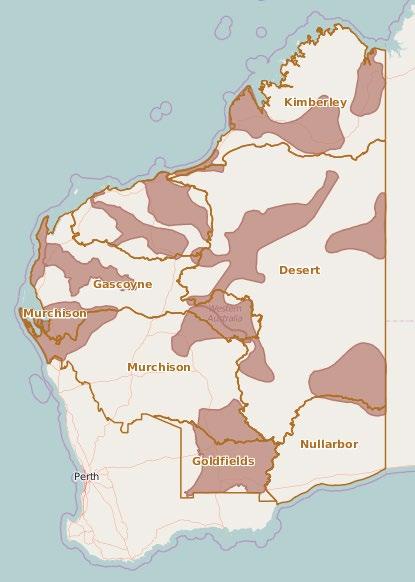
Figure 11. 2014 – 2016 Strategic Focus Areas Figure 12 2017 – 2022 Strategic Focus Areas
historic efforts in the East Kimberley, this Priority Area focuses attention on building upon a landscape scale fire program across pastoral properties currently managed in an Culturally Informed Fire style by the Kija Rangers.
6.2 Priority Areas
V4 Regional Plan 2022 Page 56 of 117
Working with properties clustered together, we are engaging pastoralists and ranger groups to protect critical habitat and encourage regenerative pastoral management.
Anherbivores.opportunity
Bounded by the World Heritage Purnululu (Bungle Bungles) to the south and the Ord/Lake Argyle Ramsars to the north, this Priority Area is building upon current partnership opportunities and sharing of resources and learnings with neighbouring native title and pastoral properties.

6.2.2 Lake Gregory
LOverviewakeGregory
exists to work with traditional owners and new pastoral interests to manage the lake sustainably with a view to expand land management opportunities such as fire, weeds and ferals up the entire catchment.
(Paraku) in the Walmajarri language, is a permanent freshwater lake that plays host to significant environmental and cultural assets as well as being a major stop over for migratory shore birds. The lake has seen significant historic damage from large numbers of unmanaged feral
Through capacity building the emerging Ranger group (Nyangumarta), this Priority Area aims to provide a focus for fire, weed and feral management. There is also a strong focus on assisting with building collaborations and partnerships to diversify learning and opportunities.
V4 Regional Plan 2022 Page 57 of 117
6.2.3 Eighty Mile Beach
The region also includes productive land systems. With the focus on development of the La Grange aquifer, this Priority Area aims to build relationships between traditional owners and pastoralists along the coastal belt with an idea to link with Roebuck Bay Ramsar and through the development of holistic property plans, fostering a landscape scale perspective on sustainable grazing practices.
ancient Paleo drainage channels from the Great Sandy Desert through to the sea, this region plays host to a series of significant wetlands including Mandora Marsh culminating in the Ramsar listed Eighty (80) Mile Beach.
6.2.4 Dampier Peninsula

FollowingOverview
Overview
6.2.5
There is a major opportunity to facilitate collaboration and assist in exploring opportunities to work together towards shared goals.
Improved employment opportunities for Aboriginal Corporations and their Ranger Groups on pastoral properties, has been identified as an opportunity to meet a workforce gap in the region.
The Nationally Heritage listed river forms the backbone for productive land systems, management of threatened species and aboriginal sites and communities. It forms the focus for building collaboration around cross tenure fire, sustainable grazing practices and protection of key threatened species habitat with both pastoralists and traditional owners.
V4 Regional Plan 2022 Page 58 of 117
The Dampier Peninsula is host to a number of EPBC species and ecological communities that are under significant threat from late season wildfire. Despite individuals and groups best efforts over a number of years, the Peninsula is subject to uncontrolled fires that burn extensive areas of country.

TheOverviewFitzroyFitzroyRiver
has been a strategic priority for Rangelands NRM for many years given the complexity surrounding competing priorities between pastoral, conservation, Traditional Owner, Industry and State Government interests.
Through a coordinated and collaborative Culturally Informed fire project, working across tenure and a sharing of skills and resources, fire will be reduced and managed across the entire Peninsula. This focus will grow to include management of weeds and ferals as well as linking in with sustainable grazing practices. The fire program will expand to include improved science and raising awareness and understanding of communities.
Recent interest in irrigated agriculture, the Aboriginal Declaration, National Park boundaries, bilbies and clearing permits has further complicated and escalated the situation, highlighting the need for all stakeholders to work collaboratively towards a shared vision.
V4 Regional Plan 2022 Page 59 of 117 6.2.6
on the previous Pilbara Corridors fire project, there is an opportunity to integrate land management in the area and build collaboration amongst the variety of land managers (Aboriginal pastoralists, Aboriginal Ranger groups and Conservation estate managers). This area (covering the triangle of Millstream Karijini Yandeyarra) is defined by the large Hammersley and Chichester ranges. The hills are particularly susceptible to lightning strikes and bush fires, and this is a major threat in the region, so it is also important to continue a coordinated approach to fire. It is important to Traditional Owners and because it houses important national parks and has existing populations of threatened species such as bilbies and quolls.
landscape, which hinders holistic land management at the landscape Buildingscape.
TheOverviewFortescuePilbaraisafragmented
Through the previous work of the Pilbara Corridors project, important relationships have developed. Rangelands NRM will continue to build these relationships and bring in Traditional Owners and pastoralists to link with the conservation estate.
6.2.7 Fortescue Marsh


The World Heritage listed Ningaloo Coast is the world’s largest fringing reef which supports a diversity of marine life including threatened sea turtles, humpback whales, killer whales, and dugongs.
V4 Regional Plan 2022 Page 60 of 117
The Ningaloo coast ranges from Quobba in the south to the Northwest Cape incorporating Ningaloo Marine Park, Exmouth’s Cape Range National Park, Learmonth Air Weapons Range and Muiron Islands Marine Management Area.
There are two key sea turtle rookeries within the Ningaloo Coast World Heritage Area and Ningaloo Marine Park, namely the Gnaraloo Bay Rookery and Gnaraloo Cape Farquhar Rookery. These rookeries
Marsh is the largest ephemeral wetland in the Pilbara region and is of national significance, being a High Conservation Value Aquatic Ecosystem (HCVAE). It is regarded as the ‘lungs of the Pilbara’ with extensive Mulga woodlands including flora and fauna of high conservation value. It is Traditional Country and the Marsh is variously shared by the Banjima People, the Nyiyaparli People and the Palyku People. It is impacted by fire feral predators and feral herbivores.
In 2015 the Marsh was excised from the pastoral estate with the goal of turning the area into a Conservation estate, a process that could take up to 10 years to implement due to the complexities of the development of an Indigenous Land Use Agreement (ILUA) with the various Traditional Owners.
TheOverviewFortescue
This provides a unique opportunity for Rangelands NRM to continue the work which commenced under the Pilbara Corridors project by working with the diverse stakeholders to create a shared ‘tenure blind’ vision for both the Fortescue Marsh Strategy and surrounding pastoral estate. This work will include Traditional Owner pastoral enterprise (Yandeyarra) and Aboriginal ranger groups (Banjima Rangers in Tom Price, Yandeyarra Rangers, Ngurawaana Rangers and the Nyiyaparli people).
6.2.8 Ningaloo Lyndon
Lyndon Priority Area encompasses a diverse stretch of land composed of pastoral estate, conservation estate and the Ningaloo Coast World Heritage Area, which has high tourism value for the State.
TheOverviewNingaloo

past decade, the Upper Gascoyne Catchment has also served as an important a hub for trialling innovative grazing practices and leading rangelands rehydration efforts. The willingness and high level of organisation evident amongst active pastoral producer groups in the Upper Gascoyne Catchment to engage in a wide range of NRM initiatives provides an opportunity for Rangelands NRM to support community led landscape change at a landscape scale.
represent the largest mainland nesting sites of Loggerhead turtles in Western Australia leaving them exposed to predation by foxes, feral cats, and wild dogs. Low rainfall and minimal runoff from surrounding catchments contribute to the exceptional condition and water quality within the Ningaloo Reef which in turn supports coral reef communities, shoreline intertidal reef communities, sponge gardens, macroalgal and seagrass communities, and mangroves.
V4 Regional Plan 2022 Page 61 of 117
6.2.9 Upper Gascoyne
TheOverviewUpper
The Matuwa Kurrara Kurrara Indigenous Protected Area, comprised of the former Lorna Glen and Eraheedy pastoral leases, is known for its unique conservation values and cultural significance to the Wiluna Martu.
Our primary role is to facilitate alignment of the various land management initiatives underway across the region, to foster a more collaborative approach between State Government agencies, community groups and the pastoral sector and to support the delivery of an integrated and community led regional land, coast, and sea management program.
Historically, the area has had disjointed management and competing priorities, limiting the ability of the community to respond to key threatening processes.
Gascoyne Priority Area encompasses much of the Gascoyne River catchment and encompasses the Kennedy Ranges, Mount Augustus, and the Matuwa Kurrara Kurrara Indigenous Protected Area. The Upper Wooramel, Lyons and Gascoyne River catchments are recognised as important areas to the health and functionality of the Ningaloo Coast and Shark Bay World Heritage
OverAreas.the

upon initiatives led by the pastoral industry over the past 10 years and linking these with the activities of conservation land management organisations including Bush Heritage, Northern Agricultural Catchments Council and the Department of Biodiversity Conservation and Attractions, Rangelands NRM is supporting improved land management throughout the corridor, integrating sustainable pastoral production, biodiversity conservation and community leadership.
Throughout the Shark Bay Yalgoo Corridor there are real opportunities to build landscape scale collaborative efforts between the pastoral industry, State Government agencies and conservation land
The Shark Bay World Heritage Area is an important asset in this corridor extending over 2,320,000 hectares and includes the Shark Bay Marine Park and Hamelin Pool Nature Reserve. The isolated, and relatively untouched peninsulas and island habitats of Shark Bay are home to five endangered mammals and harbours 35% per cent of Australia’s bird species. Many species of birds and reptiles found here are also within the northern and southern extent of their range. Ten percent of the world’s dugong population (10,000) resides in Shark Bay along with significant loggerhead and green turtle rookeries. The twelve species of seagrass found here make it one of the most diverse seagrass assemblages in the world.
V4 Regional Plan 2022 Page 62 of 117 6.2.10 Shark Bay Yalgoo

Bymanagers.building
The Gascoyne Murchison strategy delivered a corridor of conservation estate steppingstones between the Karara block of former pastoral properties south of Yalgoo, to the Shark Bay World Heritage Area. This corridor lies between the wheatbelt and the rangelands and extends from Ninghan Station in the south, east to Charles Darwin Reserve, Mt Gibson Station and up the central Midwest through several Department of Parks and Wildlife conservation blocks (Karara, Muggon, Doolgunna Mooloogool and Dalgaranga) to Hamelin station and the Shark Bay World Heritage Area in the north.
Due to the dominance of pastoralism in the region there are opportunities for Rangelands NRM to work with producers to support improved land management across the Central Murchison Rangelands and to drive and regenerate productive capacity across the landscape and improve the region’s biodiversity values.
TheOverviewCentral
Changing climatic conditions and historical degradation have placed substantial pressure on the regenerative capacity of the Central Murchison Rangelands, challenging both the ecological and economic viability of the region.
V4 Regional Plan 2022 Page 63 of 117 6.2.11 Central Murchison
The geography of the region is characterised by low hills and mesas separated by flat colluvium and alluvial plains. Vegetation is predominantly low mulga woodlands. Perennial grasses play a vital role in maintaining soil structure. Changing climatic conditions, combined with the impacts of total grazing pressure have put substantial pressure on the regenerative capacity of the landscape, challenging both the ecological and economic viability of the region.
Murchison Priority Area encompasses a vast area of land featuring a diverse range of land uses, the region is one of the main pastoral (sheep and cattle) areas in Western Australia and incorporates the local government areas of Yalgoo, Murchison, Mount Magnet, Cue, Sandstone, Meekatharra, and Wiluna.

As the national and international significance of the Great Western Woodlands has gained increasing recognition over the past five years, a greater focus has been placed on the some of the key threatening processes affecting both biodiversity and biosecurity across the landscape. These key threatening processes include altered fire regimes, loss of habitat and the spread of invasive species including weeds and feral animals.
The Ngadju people are the Traditional Owners of a large section of the Great Western Woodlands. Through the Ngadju Conservation Aboriginal Corporation (NCAC) they have sought increased capacity to undertake work that addresses their environmental concerns. Initiatives to date have included an initial fire management program, a project mapping water trees, two significant knowledge documentation programs with CSIRO and the development of a Conservation Action Plan.
Initially established in recognition of the ecological and cultural significance of the region (particularly to the Ngadju Traditional Owners), the Great Western Woodlands Priority Area has been maintained and expanded in order to build engagement and optimise partnership opportunities across the pastoral and indigenous land management interface.

16 million hectares of woodlands and heathlands interspersed with salt lakes, the Great Western Woodlands represents the largest remaining intact Mediterranean habitat in the world. It is home to more than 20 per cent of all known Australian plant species and provides a haven for a community of animal species that are now threatened elsewhere in Australia.
V4 Regional Plan 2022 Page 64 of 117 6.2.12 Great Western Woodlands
EncompassingOverview
People (Pila Nguru) have maintained continuous connection to this Country for as long time. This area focuses on managing places of significant biodiversity value which are inextricably linked with places of high cultural significance specifically permanent and ephemeral water bodies, rock holes, freshwater lakes, salt lake systems and wetlands of national significance. The Spinifex People have exclusive Native Title of Spinifex Lands and Pilki Native Title Lands determinations. They collaborate with the state on joint management of nature reserves on their Country. And they work with partners (state, federal, philanthropic, and mining companies) to help return Spinifex Country land management into balance with people and nature. They maintain important cultural sites at numerous locations.
TheOverviewSpinifex

V4 Regional Plan 2022 Page 65 of 117 6.2.13 Great Victoria Desert
Current relationships with the Spinifex People involve supporting their peak cultural and land management organisation Spinifex Land Management and the GVD Adaptive Management Partnership to undertake ranger based caring for Country activities. This involves actively managing country by reinstating traditional fire burning regimes, managing Weeds of National Significance (including a focus on the Buffel Free GVD initiative) and feral animals (cats, foxes, camels) to protect several threatened species and their respective habitats.
The GVD partnership between Spinifex, Yilka, Desert Support Services (DSS), Department of Biodiversity, Conservation and Attractions (DBCA), Greening Australia, Conservation Management, the GVD Biodiversity Trust and Rangelands NRM (serving as both contract/project manager and backbone support) arose from a desire to build a greater alliance to link isolated Traditional Owner groups in order to strengthen their capacities to look after large tracks of high value desert country.
Focus in this Priority Area aims to build on the capacity of existing ranger groups, assist in the management of Traditional Spinifex and Pilki Lands and promote the inter generational transfer of traditional ecological knowledge and integrating western science with traditional practices.
Over the next five years we’ve identified a priority area where we can focus on bringing together desert Traditional Owners (TOs), pastoralists and others together to address threats, which exist along that interface that we call the Pastoral/Desert Interface, particularly fire in the north and ferals and weeds in the south.
we have worked in the desert and pastoral areas discretely.
In more recent years, we have seen the opportunity that exists to bring these two stakeholder groups together, both in terms of the issues and the people who are dealing with them.
Reduced impact from large feral herbivores
Undertake collaborative research conducted on fire for different purposes
Improved employment opportunities for TOs on pastoral properties, meeting a workforce gap in the region
TraOverviewditionally
V4 Regional Plan 2022 Page 66 of 117 6.2.14 Pastoral Desert Interface

Mitigate climate change driven increased fuel loads impacting on productive pastoral land Expandedsystems. partnerships between TOs and pastoralists across the landscape where issues of common concern exist (fire, ferals and weeds)
These are productive land systems on the fringe of the desert. Impacted by fire, feral herbivores, and weeds. Through partnerships with KJ and DSS and other desert Aboriginal ranger groups, we seek to bridge connections to manage fire, ferals and weeds for and with pastoralists to:
V4 Regional Plan 2022 Page 67 of 117
An asset needs to be protected, improved, or managed better through a proposed project. It could be large or small, degraded, or pristine, localised or dispersed.
7 Assets
The Asset Register is a systematic appraisal of sites, locations, flora and faunal assemblages, sites of cultural value, aggregated across the landscape by the people who live, work and are passionate about the Rangelands.
There are over 400 assets on the Asset Register including offshore islands, highly productive land systems, threatened species, rivers, wetlands, underground aquifers.
Each coloured dot in Figure 13 represents a nominated asset within its subregion

Figure 13 GRID Assets Database

7.1.4 Process for Asset Selection
1. Can you spatially identify the asset,
In order to sort assets in a way that recognises their different scales and level of importance, a hierarchical classification is used. The three levels are:
• While assets at this level are of exceptional or at least very high significance, they are too large and complex to effectively manage in their entirety. They do however form an umbrella for component significant or notable assets.
• Assets at this scale have potential for consideration but only a limited subset is likely to be the focus of major investment at any one time.
Step 2: Filtering significant assets Using a simplified set of criteria, the list of significant assets is filtered down considering significance, threat levels and regional priorities. The list is further filtered as these questions are addressed:
3. Is there evidence to indicate that management actions can make a real difference sufficient to achieve a smart goal,
4. If the desired management actions are mainly on private land, is it likely that those actions would be reasonably attractive to fully informed land managers when adopted over the required scale?,
Rangelands uses the following seven steps to identify an asset for potential project development:
Step 1: Identifying significant assets A list of significant natural assets that are candidates for investment is prepared. These are separated into umbrella, significant and notable assets.
• Many assets identified are of local significance.
7.1.2 Significant Assets
7.1 Asset Categories
• Generally modest in scale, they are certainly noteworthy and will be the focus of smaller scale projects often initiated by local community environmental and Landcare groups.
• Generally, at a very large scale (e.g., the Fitzroy River) or aggregations of entities (e.g., species of plants and animals with similar ecological requirements or threats).
• Most notable assets are in fact nested within assets at higher levels.
5. If the project requires change by other institutions (e.g. local government, state government departments) is there a good chance that this will occur?
V4 Regional Plan 2022 Page 68 of 117
7.1.1 Umbrella Assets
• Usually of high to very high significance where there is potential for major investment or protection measures to maintain or enhance their values.
2. Is it possible to develop SMART goals for the asset,
7.1.3 Notable Assets
Step 5: Develop investment plans or funding proposals for external/internal/available funding.
Step 6: Implement projects that receive funding.
Step 7: Monitor, evaluate and adaptively manage projects. At this point projects are also reviewed to ensure original project design is still suitable and whether the project should remain a priority.
V4 Regional Plan 2022 Page 69 of 117
The Rangelands NRM Asset Register currently lists 50 Umbrella Assets; 236 Significant Assets; and 125 Notable Assets, totalling 411 across all classes.
Step 4: Selection of priority projects, select a short list of priority assets/projects based on the filtering information above that fit with available funding resources.
Step 3: Develop internally consistent project outlines for each asset on the reduced list. This process draws together readily available information, consisting of desktop review of publications and reports, and consultation with the community and wi th relevant experts. Information required at step 3 includes: asset significance, threats, project goal, works and actions, time lags, effectiveness of works, private adoption of actions, delivery mechanisms and costs.
8.1 Landscape scale Coordinated Approach
A significant amount of planning has occurred throughout our region in the form of Healthy Country Plans, species Recovery Plans and other local plans which are either private or publicly available. These planning documents are regularly drawn on to help prioritise and guide the management of our natural
• invest in and support community groups in building their capacity to manage their own land/sea country
To deliver this Plan, Rangelands NRM uses a constant community co design approach to the design and delivery of programs and projects.
The current Regional Plan reflects a landscape scale, coordinated approach with a focus on Priority Areas that are identified by the quantity of umbrella and significant environmental assets as well as the level of interest and activity in the area. In this way the Plan links local passion and resources to manage and conserve special environmental areas, nurtures enthusiasm and involvement, and addresses threats affecting key strategic environmental assets.
resources.8.2Community
V4 Regional Plan 2022 Page 70 of 117
Project concepts and proposals are developed with current and potential new local community delivery organisations and are linked to stakeholders and other relevant local, regional, or national plans.
The Plan and the supporting Rangelands NRM management system have community participation and continuous co design embedded. As part of our community engagement, Rangelands NRM utilises this Plan and its Priority Areas as a framework to build on past learnings and successes and to open conversations with community for new investment discussions.
8 Implementing the Regional Plan
Co design and Partnering
Our main objectives when undertaking community co design and partnering with local community organisations are to:
• deliver on ground results, at local, property, sub regional and landscape scales that align to the regional plan
The level of interaction ensures that the Rangelands NRM team monitors and recognises community aspirations, capacity, and on ground delivery activities. It helps to synthesise community priorities within the region to assist 1) community co design and partnering that achieves the main objectives and 2) provide a feedback loop to the Regional Plan reviews.
By recognising and promoting the local knowledge and wisdom of land and sea managers and complementing this knowledge with technical expertise and support at appropriate junctures, barriers and opportunities for land and sea management activities can be identified to address the Plans priorities or for further enquiry through shared learnings.
• provide opportunities to enable working and learning together through coordinated NRM programs
Specifically, we support Aboriginal groups to develop, review and deliver healthy country plans, and other plans such as Indigenous Protected Area (IPA) plans and Indigenous Land Use Agreement (ILUAs). These plans contain land management priorities and activities that meet a particular groups’ caring for country aspirations or challenges. They capture important cultural and ecological values and assist Elders to manage access to country and convey traditional cultural protocols.
The positive outcomes of Indigenous involvement in natural resource management are not only environmental. A variety of benefits come from these activities and investments, including improved health and wellbeing, cultural and social outcomes, and economic opportunities. For Indigenous people, it is increasingly documented that caring for country is intricately linked to maintaining cultural life, identity, autonomy, and health.
8.2.1 Aboriginal – Traditional Ecological Knowledge
V4 Regional Plan 2022 Page 71 of 117
Aboriginal people are a large land manager and a key stakeholder group, Rangelands NRM has developed a good practice, and engagement method to support these groups.
Aboriginal people provide a wide range of environmental services in the Rangelands including fire management, wildfire abatement, carbon sequestration and trading, weed control, feral animal control, biodiversity conservation, fisheries management, restoration of wetlands, water resource management and sustainable commercial enterprises such as eco tourism.
Long and respectful relationships with rangers and other stakeholders (including Registered Native Title body corporates) have enabled thorough consultation to ensure critical alignment between project outcomes and culturally informed land management so that future outcomes are not jeopardised, and priorities are addressed.
Table 1: Aboriginal Partners Sub Regions Group/Description Projects Desert 1 Kanyirninpa Jukurrpa (KJ) Martu people RLP Bilby 2 Desert Support Services (DSS) Wiluna Martu people of the Birriliburu, Matuwa Kurrara IPAs RLP Bilby 3 Desert Support Services (DSS) Tjiwarl people, and the Pintupi people of the Kiwirrkurra IPA, and Ngjururrpa IPA RLP Bilby 4 Ngurra Kayanta Aboriginal Corporation RLP Night Parrot 5 Ngurrara Pty Ltd RLP Night Parrot 6 Nyangumarta people RLP Night Parrot
When developing projects or assisting others to develop projects, indigenous planning input is foundational to project development and delivery To do this, Rangelands NRM works towards a coordinated, community consultation approach embedding Traditional Ecological Knowledge (TEK).
Rangelands NRM works with over 50 Aboriginal groups, see table below, and their input, guidance and passion for the country makes possible the delivery of programs and projects across the vast rangelands landscape and has assisted their ranger teams to grow. We provide a range of support to a number of Traditional Owners groups through key regional organisations who have genuine intent, based on being respectful of traditions and culture, roles and responsibilities.
4 Ngurrrara Connection
RLP Malleefowl
6 Nyikina Mangala Rangers Connection
3 Kija Rangers KLC, RLP Bilby
9 Yilka at Cosmo Newbury Great Victoria Desert
9 Aboriginal Biodiversity Conservation (ABC) Foundation Connection Murchison
11 Nyul Nyul PBC Aboriginal Corporation, Rangers Dampier fire
V4 Regional Plan 2022 Page 72 of 117
RLP Malleefowl / MERN Pilot
16 Wunamba Safe Havens
RLP Shark Bay WHA
10 10 Deserts Project Culturally Informed Fire
RLP Shark Bay and Ningaloo Coast WHAs
2 Naanda People
7 Indigenous Land Corporation Connection
Great Victorian Desert
Pilbara
3 Banjima Native Title Aboriginal Corporation (BNTAC), Rangers PEOF, Fortescue JM
4 Yingaarda people Carnarvon townsite and surrounding Gascoyne region
5 Karajarri Rangers of Karajarri IPA Connection
2 Bunuba Dawangarri Aboriginal Corporation and Rangers ERF
1 Ngadju Conservation Aboriginal Corporation, Ngadju people in the Great Western Woodlands, Ngadju Rangers
9 Yindjibarndi / Ngarluma People Connection
8 Pila Nguru Aboriginal Corporation and the Spinifex community
2 Paupiyala Tjarutja Aboriginal Corporation Spinifex Connection
6 Ngurrawaana Rangers Various
15 Yamatji Marlpa Aboriginal Corporation Connections
RLP Bilby, RAMSAR
14 Paraku Rangers Connections
4 Nyangumarta Warrarn Aboriginal Corporation and Rangers Connection
10 Yandeyarra Rangers Connection
1 Kimberley Land Council (KLC) is an administration body for some traditional owners (Kimberley) RLP Bilby, RAMSAR
2 Badimia Bandi Barna Aboriginal Corporation via Gundawa Regional Conservation Association RLP Malleefowl
Goldfields Nullarbor
7 Karajarri Traditional Lands Association
12 Yawuru Rangers
12 Gingirana people RLP Night Parrot
8 Oombulgurri people Connection
8 Central Desert Native Title Services Connection
7 Gooniyandi Aboriginal Corporation and Rangers Connection
3 Aboriginal Biodiversity Conservation (ABC) Foundation Connection
1 Yamatji Marlpa Aboriginal Corporation (YMAC) admin org for some groups (Pilbara, Murchison and Gascoyne). Shark Bay WHA
5 Robe River Kuruma Connection
1 Yamatji Marlpa Aboriginal Corporation (YMAC) Shark Bay WHA
9 Balanggarra Aboriginal Corporation, IPA and Rangers Safe Havens
This consultation and coordinated activity brings together TEK, western science and contemporary NRM practices, incorporating tools and technologies where applicable – a feature of healthy country planning. It builds both non indigenous and indigenous partners capacity for cross cultural engagement and strengthens land and sea management practices.
4 Puutu Kunti Kurrama People and Pinikura People (PKKP) Pilbara offsets
5 Baiyungu Nganhurra Thanardi Garrbu Aboriginal Corporation (NTGAC)
11 Indigenous Desert Alliance (IDA)
10 Bardi Jawi Niimidiman Aboriginal Corporation, IPA and Rangers Dampier fire, Safe Havens
4 Yadgallah Aboriginal Corporation Connection
2 Yaburara & Coastal Mardudhunera Aboriginal Corporation, Rangers Connection
RLP World Heritage
RLP Night Parrot
11 Budadee Rangers (Woodstock Abydos Protected Area) Connection
RLP Night Parrot
Gascoyne
RLP Ningaloo Coast WHA
3 Wiluna Rangers Connection
RLP Ningaloo Coast WHA
8 Yinhawangka People Connection
3 Malgana Aboriginal Corporation, Rangers RLP Shark Bay WHA
7 Murujuga Aboriginal Corporation (MAC), Rangers
1 Yullella/Bundadea Aboriginal Corporation
Kimberley
12 Palyku People (Budadee Rangers Woodstock Abydos Protected Area) Connection
13 Tjiwarl people RLP Bilby
6 Thalanyji Buurabalyji Thalanyji Aboriginal Corporation
13 Dambimangari Rangers Safe Havens
5 Nyiyiparli People Fortescue
HorticultureHorticulturalgrowersin
Overall, this delivers an integrated and robust approach to NRM with locally tailored and culturally appropriate application.
With both community and Aboriginal engagement ensuring collaboration and gaining free, prior, and informed consent (FPIC) is an integral part of our engagement ethos and duty, in our support role. This follows through to our project co design process with Aboriginal groups, including developing agreeable outputs/outcomes that are monitored, evaluated, and reported on.
8.2.2 Pastoral
A large percentage of the WA rangelands is of Pastoral Lease tenure managed by pastoral producers and involve a network of producer groups, Land Conservation District Committees and Regional Biosecurity Associations. Rangelands NRM is supporting these groups and individual pastoralists to integrate agricultural production and profitability priorities with long term environmental sustainability
Rangelandsneeds.
V4 Regional Plan 2022 Page 73 of 117
8.2.3
the 3 main regions grow a wide variety of produce, across mostly small land parcels, and due to multiculturalism, a significant proportion are Language other than English (LOTE). There is a keen appetite amongst growers and key stakeholders to re organise and build capacity
NRM has invested in on ground presence and resources to build up the trust, confidence and respect of the pastoral community through regular visits and meetings, and considerable support, advice and assistance towards the delivery of on ground work and projects. Improving understanding of the systemic pressures (beyond the ecological) and historical impacts facing both producer groups and individual pastoralists is key. This better understanding supports the co design of projects/programs and alignment of the economic, social, cultural, and environmental considerations and priorities.
Many groups in the rangelands have already gone through rigorous Aboriginal and broader community driven process that articulate their priorities through developing plans, including healthy country plans. These continue to make a substantial contribution to key asset and threat management in the rangelands and are a target for Rangelands NRM project co design and investment.
During co design, we listen and act upon the deep local and cultural knowledge of Traditional Owner rangers, which is vital in progressing the project initiation, outputs, and outcomes. Asking questions such as “What is culturally important to you?” and “Does the project/what project would align and assist in achieving your own outcomes?”
Program/project activities are focussed on expanding the adoption of leading pastoral production and land management practices to enhance the condition of soil, vegetation, and biodiversity. These opportunities are accelerated through the co design process that resources and empowers planning and action by pastoral communities, and link to rangelands ecological and production specialists, researchers, industry regulators and economists.
8.2.4 Wider Community
3.
There has been energy and activity in building connection, trust, and priority setting, although this needs to be harnessed through the extension and adoption service network to work together as a Keycollaborativeopportunities
collectively, to achieve improved good agriculture practice, area wide pest and disease management and improved productivity / prosperity.
The layers of partners and stakeholders described in the Community and Indigenous Communication, Engagement and Participation Plan include:
4.
5. Local Government 6. State Government Departments 7. Commonwealth Government Departments 8. Environmental non government organisations 9. Commercial Environmental consultancies 10. Industry / Resources Companies 11. Land Conservation District Committees (LCDC’s) 12. Regional Biosecurity Groups 13. WA Landcare Network 14. Volunteer NRM groups 15. Education 16. Producer and Grower Groups 17. Philanthropic Investors 18. Universities 19. Cooperative Research Centre’s (CRCs) 20. Research Organisations
are centred on fostering industry solutions through on farm grower led trials and demonstrations and coordinating stakeholder collaboration between growers, research station and agencies, consultants, market groups and accreditation providers. This is essential to develop a culture of grower led innovation and facilitate regional productivity, viability, and resilience.
2.
V4 Regional Plan 2022 Page 74 of 117
Rangelandstogether
NRM establishes and maintains relationships with other regional stakeholders, including, environmental conservation groups, environmental services and carbon companies, mining, oil and gas companies, fishing and aquaculture groups, agricultural extension and adoption services, agricultural industry bodies, schools, universities, Local Shires, State and Federal Government agencies, and other NRM regional bodies.
The scale of the challenges we confront in the Rangelands region mean that no one organisation or sector is able to address these challenges by itself. The only way we are going to solve these is to work
1. Pastoralists Indigenous communities (including exclusive and non exclusive Native Title holders, determined and claimant) Aboriginal Corporations and Ranger Groups WA and National NRM Network
2. The Program and Project Management System describes where Rangelands NRM stores and manages list/databases of current and previous partners and stakeholders.
3. The Regional Plan defines partners and stakeholders that are actively engaged in Priority Area community led initiatives.
8.3 Governance and Management Systems
Knowledge
and expert
Figure 14 Governance Framework and Management Systems
The connection between the Rangelands NRM’s Governance frameworks and its Systems is shown in Figure 14.

4. The WHS Management System defines the policies and procedures to ensure all delivery partners are
V4 Regional Plan 2022 Page 75 of 117
Technology development
21. companies
22. brokers consultants
Rangelands NRM manages its Environmental, Social, Governance and Finance (ESG+F) outcomes and its activities and information about its projects, partners and stakeholders using the following plans and systems:
1. The Community and Indigenous Communication, Engagement and Participation Plandefines partners and stakeholder layers and processes we implement across the region, including describing updates to the Regional Pan yearly and when needed.
• Stakeholder Communication Management System
• Limited people resources and developing capabilities and capacities
Rangelands NRM maintains a Program and Project Management System that guides our operational delivery of programs and projects in partnership with community delivery organisations.
• Workplace Health and Safety Management System
It provides the framework for the operationalisation of co design project planning, kick off, project delivery and guides stakeholder engagement and collaboration, resource allocation, planning processes, contract development, delivery organisation selection, monitoring, evaluation, reporting and communications
The program design and delivery model are guided by the Priority Areas and Objectives identified in this Plan, and includes consideration of:
V4 Regional Plan 2022 Page 76 of 117
It references this Plan, and links to Rangelands NRM’s organisational governance documents containing policies, guidelines, processes, standards, information, and data management systems, including
• Identification of umbrella and significant assets and those that are sensitive that may require higher priority resource allocation
• The status and scale of natural resource threats
8.3.1 Operational Delivery
• Importance of co design with community partners and their ownership of resulting projects and activities to achieve successful outcomes
• Financial Management System
• Scale and priority dispersion of resources over the 220 million hectare region
• The status and condition of natural resource assets
One of the most significant benefits in reviewing the Plan is the opportunity for staff, community, and stakeholders to re engage with the Regional Plan. Some people are not regularly immersed in the Plan and conducting the review has brought it back into focus for everyone, stimulating a clear and renewed sense of Rangelandspurpose.NRM
V4 Regional Plan 2022 Page 77 of 117 SECTION B
9.1 Historical Development of the Regional Plan
The inaugural Rangelands NRM Regional Plan was developed and published in 2005. In this first generation plan, Rangelands region’s landscape was broken into Sub Regions Priority Areas were developed with community consultation, resulting in a landscape scale planning approach being adopted
Regional Plan has been undergoing a full transition from the historical ‘web plan’ to an electronic document format. This is due to the level of difficulty and resources required when updating content which is interlinked with complex and dependent associations
In 2012 the Priority Areas were further refined through a series of twelve workshops held across the region. The asset threat layer of the Plan was developed using the INFFER process incorporating analysis of social, economic, and environmental factors.
Figure 15 Timeline of Rangelands Regional Plans
The historical development milestones of the regional plan are outlined in Figure 15.
9 Review of the Regional Plan

Extensive community/stakeholder consultation occurred between 2020 2022 to inform this review (further information on the process of engagement can is in the internal Commercial in Confidence (CiC) controlled document; RNRM Community and Indigenous Communications, Engagement and Participation Plan, components of the plan may be provided to our stakeholders upon request.
9.2.2 Stakeholder Engagement
In 2017, the Plan was extensively restructured using the Conservation Action Planning (CAP) framework alongside the MERI program logic. This provided Rangelands a five year horizon with a more sophisticated method of analysing the data sets, including incorporating the level of social engagement as an outcome. This was an important inclusion given the sparsely populated region. The plan articulated the fundamental importance of identifying, engaging, and developing the community to achieve long term on ground landscape scale outcomes.
In addition to the Plan review, the RNRM Indigenous and Community Communication, Engagement and Participation Plan was updated, and a new Program, Project and Systems Management Plan is also under development.
V4 Regional Plan 2022 Page 78 of 117
Plan acknowledges that the Rangelands NRM is a large region with diverse landscapes, conservation assets, threatening processes, and stakeholders with varying interests. Within a framework of achieving lasting regional NRM outcomes, the Plan seeks to articulate and address stakeholder views and aspirations wherever possible.
To inform the Plan revision, stakeholder and community engagement has occurred over the 2020/2021 and 2022 period. This took place through online surveys, specific stakeholder engagement projects, workshops, and group meetings and also one on one with producers, conservation, local government, community groups, ranger groups, the resource sector, DPIRD, DBCA, DPLH and Traditional Owner Groups across the Rangelands.
9.2 Review Method for Regional Plan 2017 22
The review considered the ‘big picture’ of the Plan and the validity of the asset based and target threat approach in the context of where the Rangelands organisation stands, and will the Plan continue to deliver on the Vision, Mission, and Objectives of Rangelands NRM. Over the last few years, funding mechanisms, politics and emerging issues offer different challenges to when the Plan was first
The Priority Areas capture the complexity of assets, threats and community interests and inform the location of priority projects. The projects are co designed with community and stakeholder partners to guide the community to deliver multiple outcomes at landscape scale.
The synthesis of project outcomes and new knowledge gathered has informed the review and delivery of the current Plan. These learnings are summarised at Section 9.3 and inform the current plan and will be incorporated into the 2023 28 plan and its supporting documents
Thedeveloped.revised
9.2.1 Fit for Purpose
As a result of the engagement and feedback the 2017 2022 Plan has been revised and forms the basis for a new 2023 2028 Plan and Rangelands NRM’s internal Indigenous and Community Communication, Engagement and Participation Plan has been updated. As part of the review process new and emerging threats were included and the asset register annotated for further revision and refinement in the 2023 28
• A Rangelands NRM survey using on line, workshops and face to face methods enabled engagement with over 2,000 partners and stakeholders in the region
The three objectives of the Plan were evaluated using four options
• Significant external RNRM investment into Rangelands project and data information management systems to increase the flow, interaction, utilisation, and visualisation of knowledge
V4 Regional Plan 2022 Page 79 of 117
Details of the Plan
• Funded by external investment, a regional Coastal pastoral Interface Community Engagement project was launched to canvas a range of issues and seek feedback on current and future directions for the Regional Plan
• Transition of the Regional Plan from a web base to document based will facilitate efficiencies in updating, provide better structure and logic, and increase readability
• Reviewed Social Media Strategy to further develop a network of followers, increase brand awareness, and engage with community, stakeholders, and industry leaders
• Climate Change and Government on equal par
• Feral pests (herbivores and predators)
Components of the Plan such as objectives, measures, initiatives and evaluating how things have evolved since the initial creation of the Plan were considered. The Plan was developed without any funding profile in mind, and the asset register is a systematic appraisal of sites, locations, flora and faunal assemblages, sites of cultural value, aggregated across the landscape by the people who live, work and are passionate about the Rangelands.
• Leave it alone If the objective was still valid and appropriately reflected our Mission, Vision and Values, there was no need to alter it.
9.2.3Plan.
The following key activities were undertaken to update the plan in 2022:
The top issues identified in this process where (in order of number of responses):
• Reviewed and updated each Sub region’s threats, priority areas, assets, and key management issues
• Biodiversity loss and Fire management
• Deep investment and engagement in the horticulture industry
• The second option was to either tweak the objective in a minor way or to alter it majorly, depending on how much has shifted in the organisation and how much was accounted for that shift in the original Plan
9.2.4 Assets and Targets
By far the largest resourcing of this review is evaluation of the assets and targets with their respective risk analysis. Assumptions for reaching current five year outcomes have not changed drastically However, since the initial construction of the Plan there is increased science around climate change, emerging assets and new threats have emerged. Due to the sheer size of the Region, meaningful community consultations on assets and priorities in the Rangelands is an expensive business, and sourcing scientific and expert advice to supplement the aspirations is resource hungry, and time
Rangelands engages widely throughout the region on new initiatives or strategic projects, and these long term projects are carefully tracked. These key projects inevitably change in some way from year to year, with new science, technology, or assimilation of new knowledge. EMU and ESRM plans (100+ property plans), and sub catchment scale rehydration projects are just two examples of the large scale longitudinal strategic projects that Rangelands undertakes.
the assets and threats is also an ongoing process. A case in point is the Kimberley Subregion (see Section 5.1) with the Threats to Target matrix and Kimberley Asset Register. These are the frontend representations of the detailed Descriptions (Appendix 1) that sit behind the snapshots. The Descriptions record the science, community, and stakeholders’ interactions to synthesise the information as represented in the snapshots. The same approach and level of detail holds true for the other 5 subregions.
Many of the environmental assets identified by the community and stakeholders strongly align with the Australian Government’s priorities for; World Heritage sites, Ramsar wetlands, threatened species, threatened ecological communities, regenerative pastoralism, climate change, soil health and carbon sequestration
Aconsuming.reviewof
The review has also shown the Plan when overlain with Australian Government priorities under the RLP, show assets such as the Eastern Curlew or Night Parrot as high Government priorities. Assets such as these will be reviewed over time and could be included in the Rangelands asset register, which now has over 400 assets. The influx of cane toads is an example of a new threat which will also be reviewed in time and is marked as a ‘potential’ in the updated Kimberley Target Threat matrix. Additional threats such as a changing climate and erosion are also flagged for inclusion in the 2023 28 Plan.
• Ensure that each of the metrics included in the Plan are realistic, but also relevant.
9.2.5 Project Alignment
• The final option was to delete the objective entirely if it was no longer relevant or necessary to track.
A key consideration is ensuring that new project initiatives are directly aligned to one of our strategic objectives The strategic project alignment has resulted in the most successful outcomes as each of the project elements fully align with the Plan
V4 Regional Plan 2022 Page 80 of 117
The current RNRM Community and Indigenous Communications, Engagement and Participation Plan contains the relative stakeholder management information and communication strategies to enable maximum engagement with our stakeholders and outlines activities to ensure our goals are achievable.
9.3 Lessons Learned
4. Transparency Sharing reports and reporting progress towards targets, tracking action and publicising results is critical to a community based organisation
6. Adaptation continually reassessing goals, incorporating new science and being flexible to make mid program adjustments as necessary.
Lessons learned from decades of work in the Rangelands and from community feedback in this review can be summarised below:
The capture of data and information within the project cycle is one of the most important factors for Rangelands NRM governance frameworks and constant improvement and review occurs to ensure we are capturing and storing information in relevant databases throughout the life cycle of all projects.
2. Collaboration and teamwork a seat at the decision making table is paramount.
1. Productive Land Systems;
2. Significant Vegetation Ecological Communities;
Rangelands NRM has program and project level MER process and guidelines in place. These include data flows through multiple databases and guidelines that are utilised and followed by Program Managers and Project teams.
8. Sound governance Shaping sound governance is continuous and ongoing and positively influences the level of available investment
9. Regional MER monitoring, evaluation and reporting that integrates project and program level data into region reporting is a focus for 2023 28 Regional Plan.
9.4 Building MER
Following the review, Rangelands NRM is developing a framework where this data can be assembled and aggregated against key indicators for the Regional Plan’s 7 Target areas:
3. Science and technology monitoring, surveying and evaluation is essential to build understanding of asset condition and trends.
7. Accountability we each trust other to be accountable, to do their bit, and be accountable through monitoring and reporting.
3. Resilient Engaged Communities;
1. Shared ownership partnerships work best when ownership is shared and supported by shared decision making, data and approaches.
5. Connecting people linking people relationships and facilitation are the real secret to success.
V4 Regional Plan 2022 Page 81 of 117
Each Program has its own Program Management Spreadsheet which allows monitoring of deliverables achieved, data capture, evidential documents, collaboration, timelines, and financial components.
4. Coastal Zones and Islands;
V4 Regional Plan 2022 Page 82 of 117
6. Flora and Fauna; and
7. Rivers, Lakes, and Wetlands.
This development will provide a measure and means to evaluate progress against the Plan at the Rangelands regional level and also at sub regional levels (Kimberley; Pilbara; Desert; Gascoyne; Murchison; and Goldfields Nullarbor).
5. Threatened Significant Species,
V4 Regional Plan 2022 Page 83 of 117 SECTION C
Building on and extending individual investment impacts, minimising duplication, value for money, and return on investments outcomes are central to Rangelands in delivering biodiversity and landscape scale change.
Table 2: Regional Assets and RLP delivery 10.1 5-year Investment Opportunities and Priorities 2017 2022 The Regional Plan reflects the natural resource management activities needed in the Rangelands Region through Asset protection and Threat reduction of impact on the identified assets. Asset Type KimberleyPilbara GascoyneMurchison Goldfields D esert Total Umbrella 21 96284 50 Significant 764933241836236 Notable 272826201014125 Totals 1248665463654411 Asset Type KimberleyPilbara GascoyneMurchison Goldfields Desert Total % Umbrella 23.80.050.00.037.50.022.0 Significant 18.410.221.212.55.622.216.1 Notable 0.010.73.80.00.014.34.8 Total % 15.39.316.96.511.118.512.977.7 Asset Type KimberleyPilbara GascoyneMurchison Goldfields Desert Total Umbrella 503030 11 Significant 14 57318 38 Notable 0310026 Totals 19 8 11 34 1055 RNRM Assets by Sub Region RLP Activities as a % of Sub Regional Assets RLP Activities on Assets
10 Integrating the Regional Landcare Program (RLP)
Rangelands NRM delivers projects and programs across the Rangelands Region for many land and sea management clients including WA State Government agencies and Australian Commonwealth Government departments.
The RLP investment is currently foundational to Rangelands ability to deliver on its purpose and to engage community to deliver positive matters of national and international. The RLP program allows Rangelands to work directly or indirectly on 55 of the 411 RNRM listed assets.
• Agriculture systems adapting to significant change:
o Vegetation and biodiversity: Across the Rangelands Region.
Rangelands NRM works on the following 5 year RLP Outcomes and Investment Priorities that are relevant to the Rangelands Region Management Unit including:
• Threatened Species: Three listed birds (Eastern Curlew, Mallee fowl and Night Parrot), and 11 listed mammal species (Black flanked Rock Wallaby, including the West Kimberley race, Woylie, Pakooma, Antina, Chuditch, Golden Bandicoot, Greater Bilby, Mala, Numbat and Warru).
• Ramsar Wetlands: Roebuck Bay, 80 Mile Beach, Ord River Floodplain and Lakes Argyle and Kununurra.
o Wind Erosion: Prevalent in the Southern Rangelands and Pilbara.
o Soil Health: Across the Rangelands Region.
• World Heritage Sites: Shark Bay, the Ningaloo Coast, and Purnululu National Park. Note The World Heritage List Nomination of Murujuga.
o Hillslope Erosion: Prevalent in the Pilbara and Kimberley regions.
o Carbon Farming: Across the Rangelands Region.
V4 Regional Plan 2022 Page 85 of 117
The degree to which these Investment Priorities lie within the Rangelands Region Management Unit is summarised in the following Table 3 below, along with notes on broader distribution across Australia. Rangelands NRM’s programs intersect a proportion of these.
• Threatened Ecological Communities: Monsoon Vine thickets behind the coastal sand dunes of Dampier Peninsula.
Distribution in Rangelands MU
Black footed Rock Wallaby
Investment Priority
There are several races recognised under this taxon; the Kimberley Race falls entirely within the Management Unit and is covered with complementary effects from the other Threatened Species and Land Management Projects.
Chosen as a key species in a Project due to significance in the region, and significance of the distribution, and complementary positive effects of management on other Threatened Species, and from the Land Management Project Design.
The Night Parrot is indirectly supported through the Greater Bilby and Land Management Project Designs. The distribution model provided is very conservative; and this rare species is likely to occur across a much broader range than indicated.
Greater Bilby 41.29% of MU 39.71% of Greater Bilby distribution
Chosen as a key species in a Project due to significance in the region, and significance of the distribution, as well as existing management actions and opportunities for collaboration, especially with indigenous groups.
Proportion of species distribution, or areas of targets Notes
Threatened Species 12 of the 70 EPBC listed species in the Strategy are within the Rangelands Management Unit
Night Parrot 52.28% of MU 95.99% of Night Parrot distribution
Nominate race 0.15% of raceMacDonnellMURanges–1.15%ofMUKimberleyrace–0.86%ofMU
V4 Regional Plan 2022 Page 86 of 117
Eastern Curlew 18.29% of MU 6.41% of Eastern Curlew distribution
Nominate race 54.08% of raceMacDonnelldistributionRanges–9.09%ofdistributionKimberleyrace–100%ofdistribution
Very linear coastal distribution makes management of coastal species across a very broad distribution difficult across the Rangelands Management Unit.
Malleefowl 36.15% of MU 41.56% of distributionMalleefowl
Proportion of species distribution, or areas of targets Notes
This species benefits from the implementation of other Projects.
Threatened CommunitiesEcological
Distribution in Rangelands MU
Eighty Mile Beach 0.08% Managementof Unit 1,755 square kilometres 80 mile Beach, and the nearby Roebuck Bay, are the focus of Ramsar work.
This species benefits from the implementation of other Projects.
Brush tailed Bettong (Woylie)
This species benefits from the implementation of other Projects.
Less than 0.1% of Management Unit 100% (2,566 square kilometres) of Monsoon vine thickets on the coastal sand dunes of Dampier Peninsula.
Brush tailed Rabbit rat (Pakooma)
2.49% of MU 22.52% of Brush tailed Rabbit-rat distribution
0.03% of MU 4.35% of Brush tailed Bettong distribution
This species benefits from the implementation of other Projects.
Monsoon Vine Thickets
World Heritage Areas 3 of the 19 are within the Management Unit
Covering a potentially large proportion of the Kimberley coastline, this Threatened Ecological Community is funded by Rangelands NRM and other parties via the Environs Kimberley team and Rangelands NRM will continue to support that group in seeking funding to manage this Threatened Ecological Community.
Roebuck Bay 0.03% Managementof Unit 682 square kilometres Roebuck Bay, and 80 mile Beach, are the focus. Our strong association with the Roebuck Bay Working Group is providing a solid foundation for this Project to be successful.
Western (Chuditch)Quoll 0.88% of MU 6.29% of Western Quoll distribution
This species benefits from the implementation of other Projects.
1 is found in the Management Unit
Central Rock rat 0.01% of MU 0.10% of Central Rock rate distribution
Ramsar Wetlands 4 out of the 65 are in the Management Unit
Investment Priority
Numbat 0.02% of MU 5.04% of distributionNumbat
Rufous Hare Wallaby (Mala)
This species benefits from the implementation of other Projects.
V4 Regional Plan 2022 Page 87 of 117
Less than 0.01% MU 0.75% of Rufous Hare Wallaby distribution
The codesign of projects and actions with land and sea managers, Traditional Owner and ranger groups, governments, NGOs, industry, resource sector, business organisations and individuals are an essential aspect of threat abatement planning and effective project implementation.
The Ningaloo Coast, and our wide network of relationships built in the conservation and pastoral sectors, is the focus of our World Heritage Area work.
Notes
This approach features in all Rangelands NRM projects and fosters stronger alignment of relevant national, subregional, and local plans and investments within the priority areas to achieve the desired 5 year and longer term outcomes.
10.2.1 Threatened Species managing grazing pressure and degradation from feral herbivores a landscape scale, Rangelands NRM is addressing core threatening processes to Bilby habitat.
Soil Carbon is the focus of our work and is a key element in our land management strategies across the Management Unit, in terms of increasing soil carbon, water holding capacity and ground cover.
Wind Erosion is one of the aspects of holistically reviewing the management of pastoral properties
Hillslope erosion is the focus of our work. This is one of the aspects of holistically reviewing the management of pastoral properties.
V4 Regional Plan 2022 Page 88 of 117
Carbon Farming
Distribution in Rangelands MU Proportion of species distribution, or areas of targets
Soil Carbon 0.002% of MU 45 square kilometres
GreaterBilby(Macrotislagotis)Throughimprovingfireregimes and
Wind Erosion 25.53% Managementof Unit 580,319 square kilometres
10.2 Actions to Mitigate Threats and Deliver Investment Priority Outcomes
Table 3: Investment Priority and Distributions
Hillslope Erosion 9.23% Managementof Unit 211,957 kilometressquare
across
The Ningaloo Coast 0.27% Managementof Unit 6,045 square kilometres
Investment Priority
The community is engaged to raise awareness, to encourage and support a holistic, sub regional response to threats.
Projects take a strategic approach and better integrate the various land management initiatives that are underway in the Region. Activities focus on threat abatement actions as described in recovery plans, implemented at a landscape scale within Rangelands NRM priority areas, and utilising the passion and energy of the local community.
Malleefowl and predator surveys, invasive weed management (including buffel grass control), large feral herbivore culling, opportunistic predator control and traditional prescribed burning to re establish a finer grained mosaic are being undertaken variously by the Spinifex, Pilki, Yilka and Ngadju Rangers teams.
Through partnering with land managers including Indigenous Rangers, pastoralists and conservation groups, targeted monitoring, and management of feral predators such as foxes, feral cats and dogs/dingos can be addressed in key sites where Bilbies are active.
Malleefowl(Nganamara)Throughcoordinateddelivery,
Parrots is improved by working with Aboriginal Ranger groups on known and likely Night Parrot habitat sites in Western Australia. Aboriginal Ranger groups will contribute to the project with their skills and expertise and learn new skills to implement the project through on country visits to assess potential habitat, establishing monitoring and provide valuable information to extend Australia’s knowledge and understanding of night parrots.
The approach also aligns with cross regional activities by collaborating with cross management unit community partners, other NRM Regional Groups in both WA and SA, and National Recovery Teams to support actions to halt and reverse the decline of the species.
10.2.2 Ramsar Wetlands
local communities are increasingly undertaking actions to protect the species either directly, or through activities of benefit to other values important to them.
NightParrot(Pezoporusoccidentalis)ThelandmanagementknowledgeofNight
In the pastoral interface groups have cooperated around feral animal control and regenerative grazing practices for multiple benefits. The combined effect of these activities is reducing threats to Malleefowl and other threatened species.
V4 Regional Plan 2022 Page 89 of 117
The project will also build relationships and encourage participation of pastoralists who manage potential night parrot habitat on the pastoral/desert interface. The Aboriginal rangers will address the most important aspects of the night parrot’s recovery and use the improved knowledge to target key sites with appropriate planning and management.
West Kimberley Ramsar sites Roebuck Bay and Eighty Mile Beach
The Ningaloo Coast and Shark Bay WHAs
Rangelandspressure.
NRM has been working to support producers first by increasing their understanding of the specific impacts of these threatening processes and practices to manage these impacts. Efforts are initially concentrated on bringing regionally relevant information to the producers via producer groups that work within project funding constraints within the Rangelands Region Management Unit.
Our primary role has been to facilitate alignment of the various land management initiatives underway across the region between State Government agencies, traditional owners, the pastoral industry and community groups to support the delivery of an integrated and community led regional land management program along the Ningaloo Coast and the neighbouring Lyndon River catchment and expand Gascoyne Catchment and into the Shark Bay and Wooramel catchment area.
Rangelands NRM engages with a number of producer groups that represent sub regions of the WA Rangelands Kimberley/ Pilbara, Gascoyne, Goldfields Nullarbor and Yalgoo (Midwest), each facing particular challenges with regards to building resiliency to climate change.
V4 Regional Plan 2022 Page 90 of 117
Rangelands NRM negotiates between parties to encourage adoption of best practice and complete information collection activities. Through working with Indigenous Rangers and pastoral land managers to support sustainable land management practices and act against nutrient and sediment runoff and invasive weeds and pests, this Project addresses core threatening processes across the entire Ramsar area.
Engagement is facilitated through the preparation of ecological and culturally aware plans and follow up works to address threats (e.g., runoff) to the Ramsar sites.
10.2.3 World Heritage Areas
Threat abatement activities include control of predator animals, large feral herbivores and weed infestations and reducing nutrient and sediment runoff into waterways and the marine habitat.
10.2.4 Agriculture Adaptations to Climate Change
We partner with producer groups to deliver locally relevant workshops, field days and establish project concept plans and demonstration sites framed around their articulated priorities. The workshop and demonstration topics and subsequent communication materials provide opportunities to address local issues and priorities related to land manager resiliency to climate change and range of linked threatening processes to pastoral production, including loss and decline of native vegetation and biodiversity on stations. These threats are exacerbated by increasing profitability requirements which are putting WA rangelands producers under extreme
• Only 1 RALF to provide extension and adoption services across 6 sub regions is insufficient.
• Insufficient investment to service 15,000km of coastline and 220 million hectares of management unit.
V4 Regional Plan 2022 Page 91 of 117
10.3 Current Investment Priority Funding Gaps
• The unfunded RLP project proposal Forging the Link Between Improved Land Management and Production Outcomes. This project identified the quantum of funding required for Rangelands NRM to further build capacity, resources and to develop on ground extension and adoption opportunities with engaged champion producers and producer groups, building resiliency of producers in the Rangelands Region.
The funding gaps in the Rangelands Region Management Unit are:
V4 Regional Plan 2022 Page 92 of 117
Environmental values Economic values Threats Other
Coastal strip of Karajarri country native title determined land
Over grazing, unmanaged tourism, climate change
Water cycle, carbon diversity, Rangelandsbasiswithinwetlands,protectsthebiodiversitytheleaflitteristheforalllifeinthe
Pastoral productivity, carbon sequestration, improve pasture available and enhancement of visitor destinations
B003 Savannah Woodland Old growth Eucalypt woodland
Vegetation and natural habitat values, fish, birds Tourism improves(rehabilitationwaterquality and retention creating a visitor friendly includingdestinationinternational bird enthusiasts), potential for bird watching Catchment too small to sufficientprovide habitat to support breeding cycle for multitude of species, grazing, fire, managementpoor(gates often left open and fences down), feral animals, human use, cattle, some weeds
B001 Munkayarra Wetland
Fire, overgrazing, woody thickening (increased Acacia, Native Sorgmon) leading to decreased natural grasses and other vegetation, micro fauna and mammals. Continuous destruction of large Eucalypts.
Aesthetic, sense of place, shade, food source
Tropical savannah woodland with perennial grass understorey, open savannah Rangeland inter dispersed with remnant rain forest. Diverse vegetation thicket and wetlands.
Derby based landcare group and local combininggovernmenttoprogress better management of the site.
Currently considered for an IPA over this lease excluding some pastoral paddocks
numberAsset Description conditionCurrent Community and Social values
11 Appendix 1 Asset Register Asset Descriptions
NAFI, Savannah burning. Needs more science and practical application of resources, cooperation between pastoralists,agencies,PLBand locally based fire management authority.
Trend is to (diminishing)decline
Wetlands and springs, intertidal zone creeks
Varied degradedgenerallybut Tourism, traditional, lack of diversity, not generally recognised. The impact on the general biodiversity is catastrophic.
B004 Frazier Downs Coastal Strip
Degraded to fair Potential to become high value tourist destination (birds), used by locals as a respite and for photography, social/economic, fishing country with water
Habitat/hollows, small mammals and birds
Extremely important for Bidyabanga Community, Krajarri Access to coast for fishing, many documented cultural places
Fire (late dry season withoutwildfire a mosaic pattern in place)
Natural wetland with permanent water (valuable in dry seasons), waterhole like a lake
B002 Perennial GrasslandsSavannah
Tourism (tourist perception of wilderness; "Pristine" Kimberley)
Varied fair to very good
11.1 Kimberley Asset Register Asset Descriptions
Tourism (Port Smith Caravan )Park
B015 Lower (WaterLiveringaReserve)
Lake Eda and other lake and wetland systems on Roebuck Station Lake and associated wetlands Degraded Community, hunting
GoodVariedto very good
Listed as Threatened in the Northern Territory (under EPBC); under equal or greater threat in the Kimberley.
Wilson Report, National Heritage listing Report
Fire (particularly too frequent, large, late season wildfires)
Hybrid economy, tourism Mining activities (adjacent)
Cattle degrading and drying the wetlands Yawuru Cultural Management Plan, Yawuru IPA Research
Carbon
Grazing and tramping unmanaged(cattle), access, mining (extraction of water, reduction in water quality)
Good to very good Hunting and fishing grounds Seagrass, turtle, Dugong, whales, fish Pearling, hybrid economy from living off saltwater resources, some outstation tourism
Unconfirmed Tourist values, cultural values
Recreational fishing, historic Agricultural production
Islands and intertidal reefs off One Arm Point
Uncontrolled access by tourists/visitors
B014 ArchipelagoBuccaneer (Sunday Island Group) Sunday Strait
High biodiversity, high numbers of endemic and threatened species.
Water Reserve Good High community and social values, historic High vale, birds breeding and nesting Hybrid economy, tourism value, cultural values
Nyikina MardoowarraMangalaWila Booroo Heritage Plan (WWF)
B016
B017
Sandstone heath communityvegetation
Fair degradtoed
Fishing, hunting, cultural connection King Tidal System, fish, seagrass,nursery islands, significant reef systems
The barrage prevents movement of large fish such as endangered sawfish in the dry season
B007 Camballin Barrage Pool
B008 Beagle Bay Tidal embayment with creeks, pearling farm, clear water
B018 Riparian CommunityVegetation
Potential mining (fracking, usage)water Northern Yield Project (CSIRO)
B012 Canning Basin (Timor Basin) Good Unknown Unknown Unknown High extractionmineral/resource,water
Recreation /cultural for food, fishing Important habitat, shelter, soil conservation, water quality
Large pool on the Fitzroy that has been dammed with a barrage (to allow development of a cotton industry in the 1970s)
High portion of obligate seeders; occurs on rocky sandstone areas that offer some protection from fire; above 1000mm rainfall zone.
Some people support the barrage as it creates a good fishing spot, but others don't support it as it prevents fish movement Infrastructureupstream.isfalling down and dangerous
Fire (Impact of large, hot, seasonlate fires damaging fire sensitive vegetation along creeks and rivers)
Vegetation along rivers and creeks above 1000mm rainfall zone
V3 Regional Plan 2022 Page 93 of 117
Feral animals (cats), high intensity/frequency fires, cattle, disease Significant extinctions have occurred. DEC Report July 2012 Ecology.AndersenEcology,RadfordPerformanceKimb.Sci.Cons.Str.Reporting.(2012)AustralRadfordand(2012)Austral
Good High community and social values, historical values, high cultural values High valuesenvironmental
B022 Camballin Wetlands Creeks and lakes Fair
Strong indigenous cultural values, fishing Indigenous, hybrid Economy Wetlands in arid area. Flood plain Grain potentialgrowing/feed,tourism Mining (coal uranium, CSG fracking) Fitzroy River ManagementCatchmentStrategy
Good to fair, high traffichuman Recreation, historical/pearling,cultural,Karajarrii country, fish traps, cultural sites breeding/feeding,Dugong whale shark/breeching, turtles feeding, sensitive soft limestone cliff area
High cultural hybridenvironmentalandtourism,economy
B021 Gourdon Bay Coastal embayment. Marine life, spawning ground for salmon, storyline dreaming places.
Suite of mammal species average body weight in the range 35 to 4200g that are still abundant in the Kimberley. Includes threatened species.
Weeds, unmanaged access, mining/impacts (on water quality and on springs) Nyikina WilaMardoowarra,MangalaBoorooCultural Heritage Plan (WWF)
B020 Udialla ((PastoralSpringsLease)Oongalkakda)
Tourism Tourism, mining, high human traffic, cracking cliff area Ranger put in bollards to stop access to tourists to sensitive cliff area
B023 Dampier Peninsula West coast Coastal strip Excellent to good Recreation camping fishing bushwalking, cultural sites, Archaeological, Lurkjarri Heritage Trail
Coastal Monsoon Vine drainageThickets, wetlands,basins,coastal dunes, creeks, embayments
V3 Regional Plan 2022 Page 94 of 117
Goolarabooloo/Jabbir Jabbir, Yawuru
Tourism (as yet largely undeveloped)
B019 Critical Weight Range mammal community North Kimberley above rainfall1000mm
Connective Springs, Peak Mounds, access to river
Tourism Industrial development mining,(gas), unmanaged access (damage to dune systems), fire, feral animals
Intrinsic value but also added value of whole suite collectively; critical to maintenance of ecosystem services (ie. turnover)Nutrient/carbon
Unknown National Heritage, food source for aboriginal people, 'appealing' species i.e., furry and cute
B026
Birdlife includingforimportant(impressive),watersourcemanyspeciesmigratorybirds.
man, Biodiversity surveys have been completed between Bari Jawi, Rangers and EK documentation of the surveys are available
Tourism / bush tucker tours, provides food for locals, tourism for birdwatchers
B025 Yarp Lake System Claypan lake system, some ephemeral, some permanent Fair to good Nimmanburr/Nyul Nyul country, cultural values
Needs more survey work to important/threatenedidentify species and their role in landscape. Noted in Wetlands report as special. Limited info. Some current work happening in the Nyul Nyul Ranges and environs
High cultural values, high ecological values, most bush foods occur here, also medicinal plants, bush foods diversity, shelter (shady areas), camping because of shelter
Dampier onMonsoonPeninsulaVineThicketCoastalSandsTEC
Current project & research work by Environs Kimberley West Kimberley Nature Project in partnership w. Bardi Jawi, Nyul Nyul, Yawuru Indigenous Rangers and SKIPA, important to manage fire understand frugivore network. developmentCarefuland tourism
Fire, weeds, shiftingfire,development,clearing,Cats,weeds,humanimpact,cattle,sanddunes
Dampier Peninsula Inshore dolphins Snubfin, Indo Pacific Humpbacks, Dwarf Spinner Excellent to good Iconic species
Human impacts (boat strike, fishing by catch), industrial development (gas)
Unique to the landscape, some flora only found here
Yawuru/Bardi/NyulUniversity. Nyul. DEC. Goolarabooloop/Jabbir Jabbir
TEC Vulnerable DSEWPaC assessing under EPBC Act for Endangered status occurrences)(mostDegraded
Vulnerable, not well known populations. Rare. Poor understanding,ecological in shore migration vulnerablepathstoboat strike. Incidental value to tourism
B027 Carnot Peaks and Kings Peak Rocky outcrop with unique assemblage of Monsoon Vine Thicket plants. Fair
Plants have cultural values bush foods, Djabera Djabera Country
Cattle (unmanaged), fire, weeds (potential).
V3 Regional Plan 2022 Page 95 of 117
25% of Peninsula flora found here, many species in restricted locations, high birdlifeendemicbiodiversity,rarefragmentednetwendemisminvertebrateecosystemorkhighly(natural),plantsandrefugeforfloraandfauna,
Fire (unmanaged late season), weeds (secondary) Flora surveys conducted here. SKIPA/BBS, TEC
Potential partnership. Environs Kimberley. Marine scientists. ANU. Murdoch
B024
weeds
B035 species clearing, fire,
Unknown but high risk / high threat Iconic loved bird Endangered species
Possible Coal Seam Gas Fracking
B032 Dampier Peninsula Gouldian Finch Limited population, distinct from Kimberley
B029 Lolly Well Springs and Bobbys Creek Cultural, Nyul Nyul Country
One of the few places left in the world where these animals procreatingare
Initial survey work by EK, Bardi Jarwi Ranges, WWF but limited information. Need population and abundance surveys and to identify key breeding and nesting habitat and assess population viability and recovery actions.
On a register PEC/TEC
Fire, weeds (Buffel grass)
B028 Yalleroo Lakes Lakes on the Savannah Plains Good to Fair Recreational sites, Indigenous cultural sites. Provides water and animalsplants, and birds
Land
Fire, mining, feral animals
B031 Edgar Ranges Headwater Geegully Creek Good Recreation, cultural, Mangala Black Footed Rock Monjon,Wallaby, Pandanus spiralis
TECs and PECs in Broome Peninsula and Dampier Peninsula
Contributes to local Aboriginal hybrid economy. Food Development, mining (on the Fitzroy River and the PeninsulaDampier coast)
V3 Regional Plan 2022 Page 96 of 117
B030
B034 Byal Byal Freshwater Sawfish Large endangered species Good Local indigenous food
moluccanumPittosporum Rare plant ExcellentVaried to degraded Rare plants, scientific Rare
Dwarf Pindan Heath, Corymbia paractica, Monsoon Vine Thicket TECs, Mangar Community PEC Recreation, aesthetic Rare plant community Fire, land clearing, weeds PEC on Broome Peninsula. Dwarf Pindan Heath. Mangarr on relic dunes. Corymbia paractica. TEC Monsoon Vine Thicket. Need improved vegetation mapping and description for wider area.
Cattle (feral and escapee), fire, weeds Needs further survey work. Some started Nyul Nyul Ranges and EK, Important Wetlands directory
B040 Roebuck Bay Entire 20 x 30 sq km embayment goodGenerally
See: Northern Yeild Project (CSIRO), (Fitzcam).FitzroyDevelopmentNorthernTaskforce,CatchmentReport
One of world's biggest rivers when in flood; 750 km in length, 90,000 km2 catchment area; much of it stops flowing in the dry season
Dampier Peninsula Greater PopulationBilby
B037 Dampier Peninsula Seagrass meadows
B038
Endangered Species considered locally extinct but recent surveys and observations prove otherwise.
Fire, weeds, feral animals (cats and dogs)
Groundwater extraction on Roebuck Plains, nutrient and pollutant rich storm water runoff and poor existing drainage networks, Lyngbya (algal) blooms, sedimentation, weeds, coastal vulnerability (to sea level rise)
NRM Report for the Protection of Priority Natural Resources in the Kimberley Strategic Regional land use plans. (DOP) Broome Townsite State of Environment Report. DOW Stormwater guidelines only consider SW conditions.
Stormwater guidelines required
B036 Fitzroy Entire(Mardoowarra)Riversystem
Unknown but high risk / high threat
Chain of seagrass meadows supporting dugong and turtle populations (both endangered and high cultural values), and fish populations
Fishing, maritime, tourism (bird watching, boating), jewellery, photography, art
Cultural values: fishing, shell collecting, hunting dugong. Other values: Fishing, bird watching, art, music, iconic to Broome's identity
B039 Lake Louisa Large lake (semi permanent) Fair. Trend is to decline Close to Beagle Bay. People value this place, Nyul Nyul/Nimanbur Country, cultural values
Feeds water to the region, threatened species, deep pools (especially valuable in the dry season), sustains fauna and flora over large area, riparian vegetation, pockets of Fairy Wren habitat
Good Recreation, strong Indigenous cultural values, Cherabin, tourism, fishing, agriculture (jobs)
Ramsar site (1990) National Heritage listed, benthos 500 species known, shorebirds, Snubfin and bottlenose dolphins, humpback whales, Dugong, turtle, fish, seagrass meadows, mangrove communities
V3 Regional Plan 2022 Page 97 of 117
Pastoral, tourism, traditional / hybrid economy, food source, agriculture, mining
Lyngbya, developmentturbidity/dredging,
Habitat needs to be further identified, species needs to be further located and managed accordingly, some preliminary work in pipeline, EK, Nyul Nyul, WWF, needs funds.
Mining (cumulative impacts of coal & uranium mining and Coal Seam Gas Fracking), human refuse, weeds, erosion, siltation, fire, feral animals (pigs), unmanaged access As nominated it includes the Christmas Creek and Margaret River tributaries.
Birdlife migratory and resident bats, strategic water source in landscape for wildlife
Important to understand how animals move and graze along the coast and sustain populations important culturally environmentally.and
Climate change, weeds, unmanaged tourism Yawuru Cultural Management Plan
Freshwater wetlands chain in a semi arid environment Degraded
Monsoon Vine Thickets, threatened species of flora faunaand Tourism
Nursery habitat, roosting soilhabitat,stabilisation
Fire, feral unmanagedanimals,access, grazing, trampling, climate change
B042 Coastal spots/freecampingcamping
Fresh water, birdlife, (Barramundi,fish,freshwaterfishnurseryetc)
source, Dugong, turtles, bottom feeding fish
B044 Fitzroy River Lower reaches River system
Fishing, hunting and camping Freshwater sawfish, cattle
B047 Roebuck Bay & Willie MangrovesCreek
Tourism Water quality, clearing for development/growthurban
B043
Small mammals, planigale and dunnart are both present on the peninsula, some possums Varied, rare
Preservation of species, very rare Nature based tourism
Weeds (Neem, Rubber NeopurraVine, campingsaltwatersedimentation,Parkinsonia),Burr,erosion,increasingupstream,
Need for trapping (camera physical)and to establish and idea of their presence
Yawuru Cultural Management Plan
Willie Creek (Nimalarragun)Wetlands
Feral animals (cats), fire (late seasondrywildfire), dingos and human impact
B045 Roebuck Bay Seagrass meadows
Local economy, fish, cherabin, turkey etc, recreation, tourism
Primary driver of biodiversity Halodule & Halophila species represented. Many endemic species in meadows, primary food for dugongs. Nursery crustaceans, young fish
Small Goldenmammals,BackTree rat, Golden DunnartsBandicoot,
Mangrove communities (13 species)
B041 Roebuck Lakes/WetlandsPlains chain
Recreational and commercial fishing
Increasing industrial and residential coastal/stormdevelopment,waterrun off (nutrients) algal blooms (smother seagrass causing a die off), speed boating over the meadows, driving on the beds to launch boats, etc
Degrading Cultural
Stable (?) Yawuru traditional use, nature appreciation
Bush tucker, community science, people would like to see more of them
Birds waders and other migratory birds, fresh water Bird viewing tours, pastoral station, bush tucker
Pastoral station, hunting (cultural take), traditional use, recreation, camping, ceremony, water
Two freshwater wetlands in an area where surface (fresh) water is scarce Stable (?)
Report: Establishing Priorities Wetlandfor Conservation and Management in the Kimberley (report by Tanya Vernes at WWF), Yawuru ManagementCultural Plan
Traditional use (Yawuru), freshwater recreational use (fishing, nature appreciation)
Good Cultural values
V3 Regional Plan 2022 Page 98 of 117
degradedGoodVariedto
B046
Poor access management, lack of care by visitors, rubbish
Primary driver of life in bay, stabilise sediments, carbon sink, nursery, shelter crustaceans,youngfish, food
Hot spot for Australia's snub fin dolphin (154). Also, Bottlenose & Humpback dolphins. Threatened dugong, turtles. Unknown
B052 Roebuck MigratoryBayshorebirds
B050 May River (crossing) Popular swimming hole Good Easily accessible
Recreational fishing (crabs), supports fish species on high tide, tourism
Declining
Targeted Finfish (Table species) Declining Recreational fishing, tourism, Yawuru traditional take/fishing (esp. threadfin salmon)
The population of migratory shorebirds is declining largely due to reclamation of wetlands in the Yellow Sea. As such, Roebuck Bay is critical to shorebird survival and benthos needs to remain in good condition.
Connected to IT2/Marine Park, Ramsar wetland
Unknown High Yawuru cultural use and occupancy, historical values
Recreational fishing, tourism (bird watching), professional fishing Nutrients (increase), pollution, sedimentation (industry and other run off, dredging), developmentpotential(marina) Roebuck Bay Working Group
B048 Roebuck IntertidalBayMud flats
Department of fisheries, Yawuru Cultural Management Plan
Shorebird capital of Australia. Remarkable variety of shorebirds on Broome's doorstop.
Coastal, dolphins most threatened species of mammal in world. Largest only(endempopulationknownSnubfinictoAustralia)discovered2005.
Tourism, art, music, photography
Cultural dugong and turtles hunted, Snubfin and dolphin much loved by community
Little is known about numbers of dolphins, dugong and Snubfinsturtles. have high incidence of injury on bodies, dorsal fins and tails.
Tourism Fire, feral animals (cane cats),toads,mining
ngStable/declini(?)
Bird watching, tourism, hovercraft tourism, nature based tourism Algal blooms impacting benthos (primary food source unleashedpeople,motorbikes,shoresespeciallyincreasedshorebirds),disturbanceonnorthernincludingcars,uncontrolledhelicopters,dogs
B051 Roebuck Bay Fish stocks
V3 Regional Plan 2022 Page 99 of 117
B049 Roebuck Bay Faunal values
Algal blooms, pollution, climate change, boat strike, fishing nets, over hunting (Dugong/turtle)
Roebuck Bay reputedly supports 120 000 migratory shorebirds representing 19 different species (1%) of international Roebuckpopulation.Bay known as shorebirds capital of Australia.
Remote/isolated high rainfall Good to very good Cultural Small biodiversitypopulations,mammal
High visitation, rubbish, increasing crocodiles, Cane Toads
B053 North Kimberley IBRA region
Roebuck Bay food web, supports huge shorebird populations, (Ramsar listed), supports very high diversity of invertebrates
Pastoral productivity
A significantly high diversity of benthic supported;invertebratesisamongthe richest mudflats in the world. Hugely important to food web of Roebuck Bay
Roebuck Bay critical to migratory shorebirds as a feeding site to enable moult migration/breedingand in the northern hemisphere
B054 Coastal includingReservesKennedy Hill Crab Creek, Dampier Creek, CoastlinecliffsYawuru Conservation Estate, Shire Reserves, Dinosaur Footprints
Tourism Urban and developmentcommercial
Biodiversity, food chain Professional fishing, recreational fishing, tourism Overfishing, anecdotal evidence of decrease in salmon stocks, declining water quality
Species dependent on ecologicparticularal niches
Varied good to degraded high cultural values multiple groups High diversity and endemism Fire, weeds
B064 Scaly Tailed Possum and RingtailRock
Pastoral productivity Mineral sands mining Production of radioactive andwasteEuro damage
Tourism sustenanceventures,hunting and fishing, knowledge/historylocal of Aboriginal female divers from past pearling luggers
Unknown Drinking water, directs the extent of future development.
Pender Bay including Pender outstationGardens Large bay Excellent
B067 Humpback Whale calving grounds Humpback Whale calving grounds
B063 Sea Turtles Across the region Australian sea turtles
NRM Report for the Protection of Priority Natural Resources in the Kimberley Strategic Regional land use plans. (DOP) Broome Townsite State of Environment Report.
Human use and impacts (by catch, over harvesting, vehicles, lights), feral predators (foxes and dogs eating eggs)
Outstations, hunting and fishing, connection to country (Bardi Jawi Country), cultural values, social history, sacred site
High Aboriginal community recreational and cultural use
Human impacts (large tourist boats anchor in bay opening, overfishing?)
B066 Myroodah Crossing Country near Fitzroy River Good
Excellent to good Recreation, aesthetic, iconic species, culturally significant species (hunting and iconic)
Vine thickets of the north and central Kimberley
B061 Tropical Rangelands Central Dampier Peninsula
Climate change sea level rises causing beach erosion, big tides, high water mark level much higher than what it was 5 yrs ago.
Rare and Threatened species Food, tourism
B056 P1 Public Drinking water source Area Thin freshwater layer extending most of Peninsula
B068
Turtle feeding, dugong breeding & feeding (seagrass), whale resting & calving, mangroves, reef, shelling, fish, migratory birds, pandanus trees different swirl on trunk, old cattle station, cultural values / beliefs
Excellent Aesthetic, recreational, Nyul Nyul Largest Humpback whale population Tourism Industrial development, farming,pearl boat strike, tourism
Need survey work to identify locations, conditions and threat, TEC
B065
Rare and poorly studied species
Development pressure, saltwater intrusion layer, recharge rates
Iconic species
High level of ground water and surface water interaction. Pastoral productivity, tourism
Fire, feral animals (cats and cattle)foxes,
V3 Regional Plan 2022 Page 100 of 117
Water quality, quantity, interactions environment.with
Drives development
Wilson report. Liquid Natural Gas site surveys. To be included in IPA Dampier Peninsula
B069 Lake Patterson Lake (permanent) Unconfirmed Cultural values
Fire (too frequent, large, late season wildfires)
Riparian habitatpotentialvegetation,FairyWren
Good degradedto Recreation, aesthetic, cultural Wetlands of national significance
Monsoonal Vine Thicket vegetation. Fauna habitat, settingvegetationfauna.Extensivebreeding,feeding,protection.diversityofIntactremnantclosetourban
Fairy Wren, freshwater sawfish
Associated fossil soil type Agricultural, mining (lead and zinc)
Desktop 3 Minyirr Park Coastal Reserve Coastal bushland reserve. Significant extent of Monsoon Vine thicket vegetation (TEC) at a federal level. Jointly managed by the Broome Shire, DEC and Yawuru
B072 Nimalaica Wetland near Willie Creek Wetlands of National Significance
Human impacts (vehicles, increasing usage), industry (dredging)
B070 Cypress Pine, Mt Elizabeth Station
Potential for cultural tourism. Bush food opportunity development. Seed source for native flora species. Ranger employment opportunitiesEducational/studypotential.
B073 Cable Beach White sandy beach Good
Unconfirmed
V3 Regional Plan 2022 Page 101 of 117
Restricted occurrence. thatIndicatorfireis not being managed well
Water runoff (brings weed seed, pollution and creates short term flooding impacting on weeds,communities).vegetationFire,arson,erosion
Amenity: cool & shady, plants and birds to observe. Cultural: meeting place, bush foods, conduct business. Social: retain community structure and traditions. Educational: for community and rangers
Fire, acid rain 350mybp old, cultural significance, fossils, unusual amenity, amphibious fish, world status
Important for animal highhabitat,biodiversity.
F003
Fire sensitive cypress pine. seederObligatethat only seeds after around 18 years.
Focal point along the river for human use
Varied good to degraded Cherabin, recreational tourism, fishing
declineTrenddegraded.GoodVariedtoisto
F002 Alexander Island Riparian /floodplain Good
Needs more survey work to further identify strategic important of this wetland as in the wider landscape. Threatened species and ecosystem connection.
F001 Devonian Reef Ancient reef (inland, far from the coast)
B071 Rainforest in the Kimberley Small rainforest patches Unconfirmed Shade, shelter
Birdlife, important water source for many species in greater landscape
Swimming relaxing tourism social events cultural sites fishing Turtle nesting, fish, invertebrates,birds,migratorybeach sand dunes Tourism
Pastoral productivity (highly productive land) Mining activity, human pressure
Good Springs/aquifers, culturally significant
Fire (too frequent, large, seasonlate wildfires)
Fitzroy Fitzroy(Mardoowarra)RiverCrossing town area and old crossing
Cattle (feral), fire, weeds
Fire, weeds, mining
Local hunting/fishing, food source infrastructure (Fitzroy River Lodge) Rubbish, weeds, erosion
Or possibly quokka. Six individuals seen but DPaW haven't confirmed sightings or species. Habitat is red spinifex/wiregrass (the proper dry country). DPaW Kununurra excited but haven't allocated $ to research
F017 Cycads (ridge loving Cycads on Fairfield Station)
Freshwater spring flowing all year round, Dinosaur footprint fossils Excellent Culture/Kids visiting country
Unknown species of rare cycads Fair to (anecdotally)good
Relic of a bygone era, part of the Devonian Reef
Late hot fires (wildfire or intentionally lit) If it suffers fire and drought, it can take years to recover.
F004 Christmas Creek River Good
V3 Regional Plan 2022 Page 102 of 117
Soil type with a unique ability to hold/retain water. Approx 1000 ha or more remaining. Good Development /jobs potential
F009 Lakes on Bulka Station
Fire (easy to wipe them Humanout), impacts (one population is vulnerable to human access, one less so)
High value grasslands dominant perennial vegetation system on the black soil plains
Feral animals (pigs), stock wandering, overgrazing, erosion (especially in tributaries), mining company access
Derived from Devonian Reef, havecan agriculture without irrigation using stored water
Bilbies, rock wallabies (wallaroo), blood finch and blue finch, Major Mitchell Cockatoo Tourism
F006 Spectacle Hare Wallaby Marsupial Unknown
Pastoral and agricultural, potential (water retention) Fire
On edge of tunnel Creek National Park boundaries
Threatened species Development, overgrazing, feral animals (cats and dogs), fire, mining and exploration
Cattle production, tourism, sustainable development, carbon trading
Locals go fishing, important source for food, stone hide
F007 Fossil Soil Type
Fair excellentto
A lot of wildlife, musk kangaroo / wallaby, birds, finch (red, white, blue), Bilby
Hunting, bush food, fishing Stock, mining (coal)
F008 Mitchell and Flinders Grasslands pastoral grazing land
Early season cultural burning, dinosaur footprints, whole area unique. Set of springs on limestone soils, needs fencing and alternative water point. People on Bulka may not know about the values
Economic production allows regional communities to exist (economic lifeblood of the Fitzroy valley without it the pastoralists can't make a living) Relatively intact, native pasture, carbon store
Good but trend is to (slowlydecline falling apart) May be indigenous or white
Vegetation biodiversitycommunities,
Pastoral productivity (cattle) Fire (hot and late) Already fenced from stock
Grazing, farming, carbon farming, significant for cattle production highly productive
Mining Rock hide that may have been for indigenous hunting and other reason.
Potential water supply for State / Region
Human impacts (vehicles driven on beach and through sand dunes)
Unmanaged tourism (high visitation rates), fire, weeds
F050 Nippa Dam (mountains around) Sacred site, songline Good Songline
River country, rock spinifex, rugged, stony, in middle of two ranges, gorge
Kimberley's largest river in terms of volume
High valuesenvironmental
F019 Clay soil types Clay soil holds water and carbon Varied Income
Wallaby rock holes, water,permanentfinches
Fitzroy River Water groundwater(ResourceIndustry in lower reaches)
Overgrazing, do nothing (e.g., don't rehabilitate), lack of management, sheet erosion
Culturally significant, recreation Geological, flora and fauna, waterbirds Tourism
Turtle nesting beach, migratory waterbirds, salmon, dugong (seagrass bed), clean beaches and good water quality Tourism
Damming, catchment impacts
Cultural, recreation Threatened Species Tourism Unmanaged tourism (high visitation rates), fire, weeds
Rare (not a commonly found structure)
V3 Regional Plan 2022 Page 103 of 117
High potential for increasing carbon.soil Best option to effectively mitigate threat is to fence and keep cattle out for years. Ripping may also be effective (anecdotally)
F033 Sollomon Creek, Rock hide
K018
80 Mile Beach Marine Park (DEC), 80 Mile beach Ramsar Area
K019 Tunnel Creek Cultural Springs, vegetation, habitatspecific Tourism (Tourismcamping/numbers), fire
K015 Eighty Mile Beach
Ramsar Area Marine Park (to high watermark) GoodVariedto very good Recreation, Cultural areas
Unknown Recreation, cultural value
K017 Purnululu NP/Bungle Bungles Honeycomb rocks/sandstone domes
K020 Geikie Gorge
Large reconstruction project proposed involving state and federal govts and Traditional Owners. Protecting habitat values for reintroductions.potential
Recreational, tourism, fishing, supply, power generation, agricultural supply for stock? Tourism, water attraction, irrigation, stock watering
V3 Regional Plan 2022 Page 104 of 117
Manmade lake as a result of damming for agricultural irrigation. Contains Ramsar site and high value conservation areas
Recreation, tourism of international importance International value due to unmodified condition Decisions ports/dams/landon use changes, over abstraction of water resource
Human impacts (vehicles, boats and erosion),siltationweeds,introductiontrailers,ofaquaticoveruse),pollution,(fromupstreamferalanimals,fire
K023
Ord River the lower part of the system
Ramsar site, high value conservation areas, notable species of threatened wildlife, source of environmental flow for Lower Ord and Cambridge Gulf.
K025 Cape Domett turtle nesting beach
Wild Rivers are listed for the state. Currently there is no wild river strategy and therefore often little or no active management
Largest population of nesting flatback turtles in Australia Good excellentto Natural heritage
Ord Land and Water spent many years eradicating Salvinia from Lake Kununurra. This or other aquatic weeds could be required.Signageboat/trailerintroducedaccidentallythroughpoorhygiene.andeducation
K021 Wild Rivers in Kimberley
Upstream cattlesiltation,quality,dischargesediment,agriculturalprocesses,runoff,weeds,irrigationaffectingwatertidalpumping,feralanimals,fire,
K024 Dampier Peninsula Water Resource Groundwater resource on Peninsula
K022 Lake Kununurra
Agricultural irrigation, tourism, local icon increasing the region's attractiveness to potential residents and businesses
Some monitoring by Ord Irrigation. Environmental flow determined by Allocation Plan. Env monitoring from Allocation Plan, EPA and Commonwealth conditions on Ord Irrigation area.
Climate change (rising sea levels and temperature. Increased frequency of severe weather events beach development,erosion),mining, feral predators (dogs), increased public visitation/use
designationCommonwealth/Statebasedonlevel of /humanmoderationimpact e.g., abstraction Good
Lower River Reach flowing from Diversion Dam and out flowing at Cambridge Gulf, flood plain
Good Former river (prior to damming) highly mportant to Traditional Owners as it is culturally significant. Varied recreational values boating, fishing etc. Iconic.
Unconfirmed Recreational use, fishing, boating, cultural, recreation Habitat, food source, breeding zone, Ramsar wetlands, floodplain, TEC, environmentvefringing/ripariangetation,aquatic
unusedunknown,Largely
Public water supplier, potential agricultural area Development, over abstraction of groundwater Present DOW groundwater investigation on Peninsula.
Largest site/beachnesting(interms of nest numbers), significant contribution to global population of flatbacks, genetic diversity
Very high cultural value and linked to Monsoonal Vine Thicket Groundwater Dependent Ecosystem e.g., Monsoon Vine Thicket
Site is remote and access is limited, hence its good condition
K026 La GroundwaterGrange Area Groundwater Resource 50 Gigalitre plan; one of the region's major ground water areas unknownLargely
Approx 300 birds, population increased through use of nesting boxes by "Save the Gouldin Finch" org. Reports: Brazil Boast et al (2010, 2011), Destine et al 2002, contact: Sarah Pryke ANU, specific nesting sites have been found and documented, multiple sightings have been recorded and documented, need more research
K031
Vegetation type Varied Iconic Intrinsic Tourism Fire, cattle
K032 Lake Argyle
Not known Horticulture potential and land use, diversification Over abstraction Managed under the La Grange Allocation Plan
Rainforest (North particulaKimberley)rly BougainvilleonPeninsula
K027 Gouldian WyndhampopulationsFinchand Ord Stage II
Inappropriate fire regimes (limited formation of necessary tree hollows with intense fire), cattle, feral animals like cats, fire, habitat oncattle/pastoralism,ofpeople/humanloss/destruction,impact,lossappropriatehabitat,impactswatersystems,fire
Manmade lake; Australia’s largest expanse of freshwater (by volume) Good Recreational, local icon
Decreasing in thetheassessdifficultunk(70's),birdearlyaffectedhabitatpoornumbers,reducedsize,bydaysofcatchersoverallnownandtoduetorarityofspecies
V3 Regional Plan 2022 Page 105 of 117
K030 Nulla Nulla Aboriginal Reserve Good
Ramsar site, new islands and wetlands, bird, fish, reptile species have adapted well and proliferated
Iconic species, beautiful species valued because of its rarity, important bird species, culturally significant
Traditional owner access, recreational Weeds (Acacia nilotica (?)), fire
McKenzie et al. (1992), North Kimberley 1.0programPerformanceKimb.Science.Cons.Strat.Rainforests,ReportingOperationalversionDEC.2012
Human impacts (vehicles, boats and trailers, introduction of aquatic weeds, overuse), pollution, siltation (from upstream erosion), feral animals, fire Ord Land and Water spent many years eradicating Salvinia from Lake Kununurra. This or other aquatic weeds could be required.Signagebintroducedaccidentallythroughpooroat/trailerhygiene.andeducation
Part of the Ord River Irrigation Scheme (water source for agriculture), tourism
Protection of area would protect Ramsar wetland downstream.further
Intrinsic endangeredvalue,and rare species Potential tourism, tourist attraction, bird watching
Healthy and increasing populations of a nationally endangered species, rare bird, endangered bird, beautiful bird and charismatic species
K054 Critical Weight Range mammal community Mornington & Tablelands Stations
K033 Broome Groundwater Area
Inappropriate fire regimes, grazing impact from cattle, weeds, feral animals (cats)
Water supplier for economic gain
Devoid of cattle and not burnt as often as surrounding landscape
Condition unknown since White Book (~1980), survey required
Degraded Potential social and economic opportunities for Traditional Owners
General habitat
Project currently underway to control mesquite. Due to seed longevity long term follow up and surveillance will be Fundingrequired.necessary.
High value connection to country for Traditional Owners
Highly productive land systems soils and native pasture types
Irrigation, tourism, lifeline, pastoral productivity Weeds (in upper catchment including mesquite)
Groundwater Area supplies Broome water supply Good limitedinformationbut Public water supplier
Pastoral grazing land (cattle), potential agriculture/horticultureirrigated
K035 Ord River Entire catchment Large river and wetland system Varied
Weeds, human use, cattle, fire, tidal pumping Sea level rise
Potential development as a tourism destination for a long distance walking trail. Becoming National Park in 2015.
Water source protection area, GW Allocation Plan Chris Gunby (DoW)
K036
Urban expansion, water threatqualityfrom land users (nutrient loads)
Lack of access, unmanaged feralcattle,animals inappropriate(cats),fireregimes
K053 Central Gibb River Road gorges (e.g., Manning, Adcock Moll)
Traditional Owner cultural value. Source of drinking water, recreation, iconic Ramsar and high value conservation areas.
K034 Cockburn Ranges Elevated sandstone plateau Good to fair Some recreational
K037 Miruiwung Gajerrong DEC Reserve Ranges and associated land Good to fair Indigenous activities
Varied
Highly Kimberleypastoralproductivelandinthe
Tourism, recreation, access to water ways
Fire
K039 Ord River Ramsar site systemassociatedincludingland Ord River wetland area estuary Good to fair Recreation Ramsar site environmentvegetation,environment,estuarineriparianaquatic
Weeds, erosion, cattle, fire
Tourism (high visitation rates), unmanaged fires, low level of management generally
K052
V3 Regional Plan 2022 Page 106 of 117
Water gulliesrangeslimestone/sandstonebodies,andassociated
Weeds, overgrazing, feral animals, erosion, fire, rising ground water, salinity
Wood River/Rust Range ConservationProposedEstate Biological Survey identified neededassets to add for CAR purposes to conservation estate Unknown
Mammals with an average body weight in the range 35 to 4200g Good
Under management by AWC, in partnership with Traditional Owners and the State
Currently $150m/year,producesexpansion will produce further income and benefit to region, expansion of another 15,000ha + in future
The site of Mornington Wilderness Camp, an important regional tourism destination. The site of AWCÆs Kimberley Conservation Program headquarters
DEC Report July Ecology.AndersenEcologRadfordPerformanceKimb.Sci.Cons.Str.2012Reporting.(2012)Australy,Radfordand(2012)Austral
Suite of mammal species average body weight in the range 35 to 4200g that are still abundant in the Kimberley
Feral animals (cats), high intensity/frequency fires, cattle, disease
Urban water supplier, recreational value Ramsar CommunityThreatenedwetlands,Ecological
V3 Regional Plan 2022 Page 107 of 117
Irrigated agriculture, tourism, hydroponics
Overuse, water catchment impacts, competing needs Key documents: Ord Surface Water Allocation Plan, importance of effective / funded monitoring program.
K055 Critical Weight Range communitymammal Charnley River, Artesian Range (ex Beverley Spring Station)
The arrival of Cane Toads within the next two years is likely to have a dramatic negative impact on riparian fauna such as goannas and freshwater crocodiles.
National Heritage, food source for aboriginal people, 'appealing' species i.e., furry and cute
Tourism, fisheriesEcologicalTraditionalKnowledge, Tourism, fire, feral animals, weeds
Under management by AWC, in partnership with Traditional Owners and the State
K057 Ord River Irrigation Area (ORIA)
Rising ground water, salinity, sedimentationincreasedload to dam, pesticide use
Intense late season fires, weeds, cattle (now removed)
Various islands (not yet public) Good Proposed new DEC National Parks and Reserve Estate, cultural values, Tourism/economic
Inappropriate fire regimes, grazing impact from cattle, weeds, feral animals (cats)
Good
K056
Intrinsic value but also added value of whole suite collectively; critical to maintenance of ecosystem services (ie. turnover)Nutrient/carbon
K060 North Kimberley and Camden Sound Marine Parks
World unique flora and fauna assets
Important destination for tourists
Tourism (as yet largely undeveloped)
Good in far fromwithdecliningnorth,distancecoast
Irrigated farmland Good Employment for community Tourism attraction
K073 Annie Creek 18 km long permanently watered stream with high quality riparian vegetation
Mammals with an average body weight in the range 35 to 4200g Good
Annie Creek provides important habitat for fauna that rely on productive riparian areas, including the vulnerable, Purple crowned Fairy wren.
K059 Ord River Water resource (quantity)
865 GL of water in 95% of years, State's biggest surface water resource 25%(currentlyGoodused)
Critical Weight Range mammal community Carson River to Yampi Military Land
K076 destockedMorningtonarea
Cattle (pressure on fencing), weeds, frequent and intensive fires
55 km of the upper reaches of Fitzroythe River flows through Mornington, as well as 80 km of its major tributaries (the Hann and the Adcock) plus all their sub catchments. The Fitzroy is a significant waterway in the Kimberley region.
Provide habitat for a range of bird species, ground dwelling reptiles and mammals and watering points for larger macropods.
The Artesian Range hosts a suite of endemic animals (about 25 species) and is one of the last places where mammals that have contracted from their former range persist.
A series of freshwater springs in sandy country Fair
The destockedMorningtonareais the largest feral herbivore free area in the Kimberley and the only area in northern Australia where small mammals have increased in density in the last decade.
The topographical complexity of the Artesian Range is unsuitable for introduced large herbivores and probably contributes to mild fire patterns by creating a series of natural firebreaks.
Weeds, fire (extensive and intense late season fires) Since stock were removed in 2004, ground cover of grasses and herbs has improved and density of small mammals and reptiles increased within the destocked area.
K077 Fitzroy River on Mornington Station
The gorges along this part of the Fitzroy are important destinations for tourists.
Fire (hot, late season), weeds Parkinsonia),(especiallycattle (along some sections), imminent cane toad invasion
192 000 ha of highly dissected sandstone range containing a range of savanna woodland, riparian, gorge and rainforest habitats
The Fitzroy River is a significant waterway in the Kimberley and the health of the upper catchment is important for river downstream.health Tourism
V3 Regional Plan 2022 Page 108 of 117
A 40 000 ha area was fenced and had stock removed in 2004. The area contains savanna woodlands, black soil plains, creeks, rivers and parts of the King Leopold Ranges Excellent
K074 Marion Downs spring fed wetlands
K075 Artesian Range
Fire (extensive, intense, late season), feral animals (cats, cane toads)
Good
The Fitzroy River on Mornington has high fish densities. Removal of cattle, weed control, and fire management, has also reduced erosion and improved riparian vegetation in the catchment.
Excellent
The springs have suffered from considerable trampling by stock which has caused some erosion and damaged vegetation fringing the margins of the springs. Wetlands fenced in 2010.
Largest migratoryresourceKimberwetlandfreshwaterinthecentralley.Importantforresidentandwaterbirds.
The Chamberlain Valley has been stocked, but not intensively, for several decades.
K079 Chamberlain River Valley
High quality habitat for the Endangered Northern Quoll, and several other species of small mammal, including the Northern Brown (unusualBandicootinthispart of the Kimberley). A rich flora, with several species more usually distributed further.
Fence erected around lake in 2005 to exclude cattle. Program in place to maintain fence and monitor response of vegetation and birds to destocking. Bird hide built beside the wetland by AWC.
The rocky sides of Sir John Gorge and environs provide extensive habitat for the southernmostKimberley’s population of Northern Quolls as well as substantialsupportingpopulations of Short eared Rock wallabies and Common Rats.Rock
Fire (hot, late season), herbivores (cattle and other), weeds
K078 Sir John Gorge
The Chamberlain River is part of the Durack River Catchment. The section on Tableland flows north east 120 km between escarpments of the King Leopold Ranges
The Phillips Range has been burnt too frequently, and some of its valleys are damaged by cattle and donkeys.
K082 Lake Gladstone Seasonally flooded, freshwater lake Good
Cattle have been removed from the area and fire patterns actively managed since 2004. Potential dramatic impact on Northern Quolls when Cane Toads arrive within the next two years
Fair Is contained within an indigenous pastoral lease (Yulmbu Aboriginal Corporation).
A 14 km long gorge formed by the Fitzroy River as it cuts through the King Leopold Ranges on the eastern boundary of Mornington Good
Fire (hot, late season), feral animals (imminent arrival of Cane Toads)
The Chamberlain River Valley is habitat for a range of savanna bird, reptile and mammal species. Gorges coming into the valley from escarpments on either side may be important habitat for Northern Quolls, Short eared Rock wallabies and Wyulda.
Tourism (attractive location for birdwatchers) Trampling and overgrazing (cattle), mismanaged fire, weeds
K080 Phillips Range Sandstone range with gullies and complex rocky habitats Fair
V3 Regional Plan 2022 Page 109 of 117
Fire (hot, late season), herbivores (cattle and other)
Good
Wetlands, lots of animal life, threatened bilbies, marsupial moles
Cattle, weeds Needs more survey work
D038 Mandora Marsh Unique inland mangroves part of mile80beach, Ramsar Area
Degraded Culturally important area Mangroves, Migratory Waterbirds Pastoral Pastoral activities, weeds, animalsferal Ramsar 80 Mile Beach
Traditional Ecological Knowledge
Munro Springs Water and animal places Song Line, special dreaming place, birds and animal resources, freshwater springs in the desert
D047 Salt Creek Inland Mangrove Creek Good Climate change
Tourism, fire, feral animals, weeds
Good place for Karajarri and Mangala to visit, extremely valuable because they know stories for that place, campground, cultural place
D046 Wetlands of the Great Sandy Desert Desert wetlands
Feral animals; camels, cattle, cats, foxes, feral herbivores (camels)
Local people want a balance between pastoral business for income and protecting ecological/cultural values
Mining, ground water depletion, predators and herbivores (camels, cattle, foxes)
K083 North islands)offshoreKimberleyislands(31
feral)(becauseonGood/conditifairof
430,000 ha on the borders of Greatthe Sandy Desert and Tanami bioregions, south of Halls Creek. Includes Lake Gregory, Mulan Lake, Lera Waterhole, and Salt Pan and Djaluwon Creeks.
Current feral animals (wild horses). Potential development)tourism(overstocking/grazing),cattle(over
D004 Paruku (wetlandProtectedIndigenousAreacomplex)
Overgrazing cattlehorsesapproximatelycurrently7,000wildandover10,000
Cultural (Men and Women's sites), Traditional foods/medicines, recreation
Difficult to access, rangers want to do trapping (camera and physical)
Good degradedto Cultural, recreational, scientific Important for desert Bilbysfauna,, wallabies, birds, Jila need to be maintained for Cultural values and wildlife.
D048 Walyarta (Salt Creek) Karajarri Nygmarla Country Ramsar site
Difficult to access needs road to be regraded, DEC fund as a ecologically important site of value, rangers want to do a biodiversity survey
Key document: Wetlands of the Great Sandy Desert by Dr Vic Semenuik
Melaleuca woodland, restricted animalshotcommunity,batbiodiversityspot,varietyof DEC reserve
Wild / very good Cultural values
Various islands (not yet public proposed new DEC National Parks and Reserve Estate) along the coast between Wyndham and north of Broome
Source of fresh water, supports rare flora and fauna Tourism, pastoral
D008 Lake Gregory (the lake itself) Saltwater lake Good to fair Cultural/Kids visiting Rare flora/fauna, birds, fish Tourism, fishing, pastoral
Grazing and trampling by camels and cattle, altered fire regimes, unmanaged ground water levels due to petroleum exploration and mining
Tourism
D045
V3 Regional Plan 2022 Page 110 of 117
World unique flora and fauna assets
D041 Dragon Tree Soak Nature Reserve Isolated wetland refuge, freshwater spring Fair condition Significant cultural site, cultural site of significance,
Weedy degradedand Fishing and camping spot, culturally significant Fish, crocodiles,freshwaterlotsof birds (including rare birds) Fishing spot
V3 Regional Plan 2022 Page 111 of 117
Drinking water, camping areas, traditional use, hunting areas, cultural significance
High biodiversity, large tidal range means unique ecosystems,reef shellfish species
No Number Jingleja
Culturally significant for Bunuba people, fishing, camping, swimming
Refuge for habitat/biodiversityunique
Overfishing, increased tourism which will cause overfishing, potential damage to reef ecosystems
High biodiversity, fish, birds Tourism, fishing and bird watching Weeds, cattle, tourism and other incorrect human use
Flows on full moon. Needs fencing to keep feral stock out and alternative water point. Cattle can get in but landholder tries to keep them out, feralmainlystock
Excellent and pretty stable Fishing, good tucker, education about passingtypes/names/breeding/spirits,fishontraditionalknowledge
freshwaterhealthyrainreliableGood,means
Human impact, cattle Be a good idea to map the sites, biodiversity surveys
Very Good Good for firewood and bush tucker
Traditional places, important meeting places, places for artefacts, skeletal remains
No Number Mangroves Mangrove ecosystems in estuaries
No Number Fish diversity and fish stocks
Monitoring of fish, fish diversity to ensure that it doesn't decrease
Restricted human access means important refuge for particular animals
Erosion, grazing. Low threat over all as low levels of access.
D049 Pepperpot Springs Freshwater spring on Lawford Creek Good
Freshwater spring, artesian fed, fish
Rock and coral reefs that fringe the coastal areas ntGood/excelle
No Number Middens Shell middens
No Number Fitzroy River between old crossing and Geike Gorge (Danaggu)
High biodiversity, water source for animals, habitat for some fish, birdlife
Habitat for fish and therefore fishing, recreation and diving
Human impact, vehicle use (4x4's) and motorbikes, weeds
River ecosystem with migratory wildlife Good degradedplaces,in in others
People (human impact), erosionnearby Need for baseline study
High diversity of fish exists across a diversity of habitats
No Number Freshwater Places Lakes, soaks and springs of various sizes
Climate change, boats and anchor use, human impact monitoring is important, lots of different reefs/reef diversitysystems, of reefs
humanbecausedegradedbecomingGood,ofuse
No Number Fringing ecosystemsreef
Provide good fish for people
High diversity across the marine ecosystem Money saved for other things by catching fish
Need to restrict access and educate people about their presence and importance, need to map these sites to restrict access
Weeds block access, stray cattle, incorrect human use
Water holes next to Fitzroy River in the dry
Wetland ecosystem that is intact, lots of birds, migratory birds Potential for bird watching
No Number Ski Lake Wetland Lagoon on Fitzroy River Flood plain yGood/health Bird watching, some fishing high levels birds,birdlife/migratoryoffish
Fair condition Meeting place, camping ground Birds, fish (rare species), biodiversity
No Number Derby wetlands Wetlands near the town of Derby Pretty good
Fishing vehicles pass through to put boats In water
No Number Tumblegridiron Water holes on Fitzroy River System Good Fair
No Number Mud Creek Mangrove System Major creek mangrove and estuary system Good better)(need Fishing
Spot for tourists to stop and birdwatch/take photos
No Number Yabagurri
No Number Gurrigurri Dam with wetland healthy Meeting place, fishing place and camping ground Birds and fish Rubbish, weeds around the banks
No Number Black Rock: Sand Dunes Sand Dunes
Weeds, erosion, human highimpact,traffic Woman ranger doing revegetation in the
No Number Lake Alma Fresh water lake and wetland system healthyreasonablyGood, Fishing, bird watching, educations about bush/wetlands Birds, fish, crocs, biodiversity Cattle
Cattle Not really used and therefore not much human impact, rangers done work (monitoring)
Major marine nursery for crabs, barramundi, turtle, mangrove system, fish and Foxesbiodiversity,Importantcrustaceans,formarineBirds,Flying
Not many people use it anymore, not as many as used to use it
Good place for fishing, good place for camping and taking pictures Fish, birds, biodiversitycrocodiles, Camping area for tourists, fishing spot for tourists Tourism, human impact, rubbish, vehicles and erosion
nice place to go with community members Birdlife, big biodiversity, fish Cattle
biodiversity,Birdlife/migratory,goannas and snakes People/human impact, cattle
Humans, rubbish, maybe cattle, weeds from Derby township
Derby community use it to learn about wetland ecosystem
No Number Buttlers Lake Wetland land area Pretty good
Government bore that has become a wetland Unclear but healthypretty Fishing and swimming hole
V3 Regional Plan 2022 Page 112 of 117
Need baseline data about biodiversity and tourist impacts
No Number Wirrjitnirl Springs Freshwater springs in semi arid series of 4 or 5 springs, spring system on edge of marsh and pindan
Pollution from vehicles, cattle
Fair, degradedpartly Camping ground, access to beach for locals and tourists
Tourism Tourists, fishing practices
Coastal dune ecosystem, plantscoastal
No Number Coastal Dunes Cowrie Beach Coastal dunes wed by tourists Fair to rangerbetterbecomigood,ngwithwork
Freshwater source in the desert, birds, lizards (possibly bilbies) reports from elders
Currently monitored for birdlife by rangers and AQIS, rangers do work there
Camels, cattle, greater tourist damage
Big cultural campgroundsignificance,meetingplace
Has improved with work from rangers putting up signs and restricted access, Erosion has decreased through restricting tourist traffic and improving vegetation condition, still discovering burial sites in the area
Meeting place
Difficult to access, want to do more work there to access
Main camp site, swimming hole, living water, traditional campground, water hole, swimming, water source for people
Huge biodiversity value, fish, lot of (migratorybirdlifebirds)
No Number Tohamma Springs Freshwater springs accessdifficultbecauseunknownRelativelyit’sto
bad, infested by bulrush, no flow due to noopencamels,bulrush,nowater,fish
Local fish population,(perch)water source for native animals (brolga, emu, bush turkeys, kangaroo, dingo, birds, sand, goanna, Major biodiversity,Cockatoo,Mitchell'slocalhotspot on the edge of the desert
No Number Loombu Loombu
Weeds: Buffel grass, bulrush (Typha orientalis is choking the water, big infestation), Sesbania , Gallions curse; Feral animals: Camels, cattle, cats Weed work has been done, need investment/energy,significant weed work has made a difference to the bulrush. This needs to be expanded and follow up is required, ongoing work could return the health of the water hole for people and the environment
No Number Injitana springs Freshwater spring ALT reserve healththreateningcattlecondition,Fair
Dune ecosystem, birdlife (migratory birds)
No Number Cork Bark Grass area of coastal plains
Trading place Cattle stuck in springs
Meeting place, campground for old people, culturally significant
Rangers have conducted a biodiversity survey (with biodiversity consultant from KLC) there to establish baseline date
Water hole in the desert, major water hole, freshwater course, flow of water when bulrush isn't present
V3 Regional Plan 2022 Page 113 of 117
Pretty surveybiodiversitybasedconditiongoodon
Tourism from Pt. Smith Caravan Park, fishing, tourists Erosions from tourist vehicles
Fire, cats
Burial sites, tourism, cultural sites
Biodiversity, rare species lizards/skinksof found during biodiversity survey (1 new species), 58 species, 20 bird species
Okay, healthy
No Number Nealy's place Rock hole (top), water hole (below)
Losing water, camels (lots), Sesbania , drought, pastoral bores taking water, mining, possible changes in ground water, Madins Lake dry, Sesbania cannabina (a new weed) covers the lake and is thought to be increasing the rate at which the lake has dried out, feral animals (camels)
Important source of permanent water, reliable water source, campsite
Camping ground, water source in the desert, important cultural place
Needs revegetation to protect water, weed control has been successful
No Number Pirnini
No Number Wili Remote water source Okay Camping Ground Unique populationMelaleuca , dingo, bush turkey, emus, Major Mitchell's Cockatoo
No Number Purlawalla
Soak water hole in the desert, main water source for animals and people
currentlyBad, dry, never been dry before, dry becauseconditionpoorlake,it is dry, weeds (Sesbania ) cover the lake
No Number Kaningarra Rock hole, water hole Bad, waterchokingvegetationthickhole
local source of water for animals, kangaroos, birds (finch) wren, Major Mitchells's Cockatoo
Ferals (lots of camels), weeds (buffel grass) choking out desert walnut trees and increasing fire intensity
Camels making water dirty through silting water, weeds creepers),(snakeweed,dirtswater hole, tourism
Could be fenced off
Camels, cats, weeds: gallons, buffel, snake weed
V3 Regional Plan 2022 Page 114 of 117
Rock hole camelsdirtywaterbottom(below)watermoderate,(top)holepoor,ofholedueto
Lake in desert, usually permanent source of water, currently dry, previously permanent lake in the northern part of the Great Sandy Desert
wallaby, emus, reliable water source for animal populations, large aquatic area in the desert, unique ecosystem
weather station and water monitoring equipment established for research opportunities.
Lake is said to never previously been dry, rangers are keen to develop a strategy for managing the Sesbania
Near Canning Stock Route
Emus, Zebra Finch, brolga, dingo, hawks, bush turkey, local biodiversity hot spot, Significant stand of desert walnut trees
Rock art, water source
Camping, hunting, swimming hole local animals, source of water Tourism from the Canning Stock Route Weeds (snake weed, buffel), ferals (camels, cats), tourism brings weeds, rubbish
Tourism, camping, bird watching Bad tourism, vehicles, erosion of dune systems
Degraded but backwork,throughimprovingbuiltup
Good bush tucker, good picnic spot, well used by locals
High plant and animal biodiversity threatened ecological community
Tourism, fishing spots, family spots, camping, education about traditional knowledge
No Number Middle Lagoon Coastal area popular with tourism
Previous work has been done at the site with Nyul Nyul rangers environmentalistsand in the Kimberley
workneedsimproving,Fair,more
Fishing area, education of young people about fishing
Whales and offshore breeding sanctuary Humpback whales off the coast Good
Unique mammals and breeding sanctuary Tourism (whale watching), potential funding for research Human use of marine environment, overfishing, overuse, tourism
Previous works have been successful in reducing the impacts of tourism
Improving Culturally significant, good for fishing, hunting, camping, education about traditional knowledge
No Number Fish traps at Norman Creek Fish trap (rock structure that can trap fish)
potential for research of breeding behaviourstrends/sightings,
Good placesinfromdegradedplaces,intourismother
Marine crocodilesbiodiversity,
Previously a pearl farm, now derelict, lease is up. Nyul Nyul rangers have conducted seagrass monitoring, interest in establishing a marine research centre, interest in researchdolphin
Culturally significant, good place for fishing, hunting, camping
V3 Regional Plan 2022 Page 115 of 117
Important to cultural values and seasonal knowledge
weeds (buffel grass), fire (nearby burning), ferals
Unique environment, vine thickets, marine biodiversity, terrestrial biodiversity
Crocodiles, biodiversitymarine
Source of food Tourism (although less than Middle Lagoon), strong tides Good potential for biodiversity surveys and traditional combinationknowledge
No Number
No Number Arrow Pearls, Pearl farm Significant bay and seagrass bed
Fair, repairsneeds Culturally significant, fishing, hunting, camping, knowledge/educationtraditional Crocodiles, fish diversity
Source of traditional food, tourist attraction Tourism, storms, lack of proper maintenance
Sea grass beds, turtles feeding, dugong breeding and calving area, very significant biodiversity
No Number Fish traps at Middle Lagoon Fish trap (rock structure that can trap fish)
No Number Fish traps at Weedong Beach Fish traps are extensive in this area
Source of food, tourist attraction Tides, tourism, improper use Potential to combine traditional practices with marine biodiversity recording
tourism, potential for research base Tourism, bad boat use, over hunting overfishing by locals
No Number Murphy Creek Vine Thicket Monsoonal vine thicket Fair to good
No Number Weedong Freshwater place, springs soaks, biggest lake ecosystem on the Dampier Peninsula
Good, pristinehealthy,very
Significant crocodilesecosystem,freshwaterbirdlife,
remai30%howevercyclones,fromDegraded20ning
No Number Freshwater places Nyul Nyul country
Potential for tourism Climate change, ferals (cows) weeds
Camping area, meeting place, culturally very significant (man's place), cultural meeting place
No Number Pearl bed at Arrow Pearls site
extensiveGood Meeting places, source of drinking water for people, living water is culturally important
No Number Lake Louisa (Rubbabundnin)
Freshwater sources across the Nyul Nyul country on the Dampier Peninsula
Pearl bed (30% of pearls remaining)
Large and significant lake, freshwater ecosystem Good
Hunting area, picnic area, camping area
Rare fish; milk fish and ox eye herring, bird life, goanna, turkeys Ferals (donkeys, cattle)
Shell middens are also present in the area, strong spiritual presence in the area
V3 Regional Plan 2022 Page 116 of 117
Source of drinking water animals,for birdlife, diversity of plants and animals (biodiversity hotspots)
Tourism potential, graveyard Seabed biodiversity Pearls Tourism, Storm action
Minor tourism Weeds (coffee bush, senna), ferals (donkeys, cattle), tourists