
RAMON VIVANCO Architecture and Urbanism Portfolio * *
Regional development perspectives Merketal
3026242018161210080406403446
Resilient
DykeMarconipleinMSc.Thesisupgrade in
Environment
Design Leisure
Lines
CVEthiopianAgricationRooftopSuiteSingleStiltsPlacemakingZschochernplatzLabHouseFamilyHouseJPApartmentruraldevelopmentUrbanismArchitecture
Multistorey
Content
Mangrove Recovery Office
Manglar
Flood Risk Management Quick MultistoreyKalkerhauptstraßeScanResidential Architecture Paulinenstraße
Ostwestfalen-Lippe Raumbild II, Sustainable Mobility Assessment a complex urban context 2 Residential Architecture Ecological Machine CitiesHighrise Building Responsive Facade ReadingDistrictBetween (BSc. Thesis)
4 5 RAMÓN LUIS VIVANCO ORDOÑEZ
InDesign.
Languajes Spanish C2 - Native English C1 - Full Professional Proficiency German B1 - Limited Professional Proficiency Portuguese B1 - Limited Professional Proficiency SpaceEnscapeSketchUpAutoCADSyntax Depth Map X. MS Office Suite Architect & +49ramon.1369@gmail.com13.12.1993EcuadorianUrbanist15201384182
Taller Social Latinoamericano TSL, Design and Construction, team Caá Porá (Ecu). Panamá. Construction Workshop, Al Borde+El Sindicato, adobe technique. Ibarra,
Think Tank, Bremen, Germany. Research on Energy transition for utility providers. (04.2022-05.2022)
Erasmus+ traineeship programme 2021/2022 Deutscher Akademischer Austauschdienst (DAAD) Scholarship 2019/2021 Study Scholarships for Foreign Graduates in the Field of Architecture
https://issuu.com/clawcf/docs/seacabolatinta_5-digital_14d300c1723654/132Publicationrors-09-13-2016/https://www.designboom.com/architecture/natura-futura-arquitectura-invisible-portal-mirInvisiblehttps://www.archdaily.com/898027/stilts-house-natura-futura-arquitecturaStiltsNaturahttp://baq-cae.ec/ciudades-resilientes-recuperacion-del-manglar/CategoryFuturaProjectsHouse(designteammember)Portal(designandconstructionteammember)(paper)PublicSpace:readingbetweenthelines
Awards and publications
M.Sc. Integrated Urban Development and Design at BauhausUniversität Weimar. Bachelor in Architecture, Universidad Técnica Particular de Loja, AbroadEcuador.studies. March-July 2015 semester at Universidade de Caxias do Sul, Brazil.
Work experience
201520182021
Architecture and Urbanism Internship at DeZwarteHond, KölnGermany. (10.2020-03.2021)
Extracurricular Certificates
Taller Social Latinoamericano TSL, (Latinamerican Social Workshop), Design and Construction, team RAMA (Ecu). Ecuador.
201520162017
Education
ScholarEcuador.atQLab
Award: Gold Medal, Panamerican Biennale Quito 2016 Last Year Landscape and Urban Design
20162017202020212022
Proficiency AdobeVectorworksArchiCADRhino+GrasshopperQGIS.Photoshop,Illustrator,
Architect, Design Leader and Project Manager, at Simbiosis Construction and Real State Development. Junior Architect at Natura Futura Arquitectura, Babahoyo, Ecuador. Design and construction projects.
Architecture and Urbanism Traineeship at Cityförster, RotterdamNetherlands. (10.2021-03.2022)

6 7
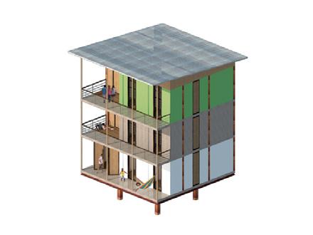
Location: Loja, Ecuador
This project answers the request of a young professional to build an apartment on a rooftop of a 4-stories high building with scenic views in the low-Andes region of Ecuador. The layout of the flat takes advantage of the site location and panoramic views. The material selection seeks to provide warmth and identity to the project. The wooden ceiling and floor frame the brick walls, highlighting the color variations on the locally produced bricks. These elements seek to provide a contrast between a warm interior and the windy and cold weather of the andean city.


JP
Role: Design, construction
Design: Simbiosis (Ramón Vivanco & Fabiola Mogrovejo)
Floor plan

Rooftop Apartment
Type: Residential architecture

Date: September, 2019
Suite
Type: Residential architecture


Design: Natura Futura Arquitectura
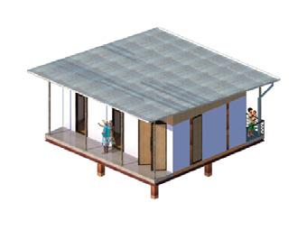
8 9 Ground Floor
An architecture that re-appropriates the idea of tradition and flexibility as a way of dwelling in the city. It is proposed in its composite to surround the living space with baked bricks that are also a traditional material in the local area, with some of the main objectives, not to use glass in their windows, incorporating traditional elements such as chazas (traditional wooden jalousie windows), providing wind and sun protection necessary for the tropical climate of the location. The composition, predominantly horizontal, is lightened by a system of teak pillars supporting the roof structure independently. The two volumes enclosing “servant spaces“on the ground floor and “served spaces“ on the raised level reference the architecture of the tropics and flood-prone areas. The proposal integrates the outside and the inhabitants’ day-to-day activities generating micro-climates. Materials and composition go hand in hand to produce light and yet secure spaces.


Date: September, 2018
Role: Design, drafting, constuction detailing
First ElevationFloor
Stilts House Single Family House
Location: Villamil, Guayas, Ecuador

Role: Architecture design, 3D modeling, details, drafting
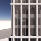
Multistorey Residential Architecture
The project’s overall idea consists of addressing the site’s specific location. The starting point to consider is the sloping terrain and the location at a vital corner. The major decisions are reflected in the location of the main entrance and the garage entrance prioritizing a more convenient entrance connected at the corner of the building facing the most active street. Meanwhile, the garage entrance takes advantage of the sloping terrain along the Paulinenstraße, on the north side, to minimize the slope of the required ramp to access the underground level. The internal distribution takes advantage of the open areas oriented toward the internal patio, providing living and most sleeping areas with south and east orientations to private and calm open spaces. Similarly, the volume of the building is shaped to optimize the internal distribution of spaces and circulation while ensuring the integration of the building into the urban context. The stairwell located at the corner of the building offers optimal public-privateratio and a smooth transition to each apartment unit from the main entrance and the underground garage. The last floor is set back from the north facade to match neighboring building heights and to offer better quality for the living areas providing a balcony along the northern side.
Date: August, 2022
10 11 Paulinenstraße 2
Location: Bad Sulza, Thüringen, DE
Type: Residential architecture
Design: Ramon Vivanco (collaboration with Dipl.-Ing.(FH) Kevin Schmidt at SB-Projekt, Apolda)
%811 6286m B B C C -1,8 -3,0 AbfallbehälterrauTechnm 0 0 0 A A Street Leve 10 Tiefgarage Mieterkeller Technik 12,86 m² Abfallbehälterraum 12,86 m² Mieterkeller MieterkellerMieterkeller Mieterkeller Mieterkeller Mieterkeller Mieterkeller TiefgarageZufahrt GSPublisherVersion B B C C A P 6 P % 4 Dach 1 100 A 1 2 03EinganB B C C 18,2 3,8 15,3 13,34 ±0,0 -1,00 A A P 11 +0,6 Paulinenstraße UntereMarkstraße NachbarbebauungSchlafen Schlafen Terrasse Terrasse Grünfläche Schlafen Bad Bad Bad Kochen Kochen Kochen Flur Diele Diele Wohnen Wohnen Wohnen 04 6 05 B B C C 15,37 18,2 2,00 +3,0 A A 1 OG 01 1 100 Schlafen Schlafen Balkon Balkon Bad Bad Kochen KochenFlur Flur Kind Kind 1 Kind 2Wohnen/EssenWohnen/Essen 8B B C C 18,29 15,3 0,46,6 7,2 +9,0 A A 3 OG 3 1 100 Schlafen Balkon Wohnen/EssenKochBad Kind Flur Kind 2 Kind 2 Ground Floor 1. and 2. UndergroundStorey 3. RoofStorey

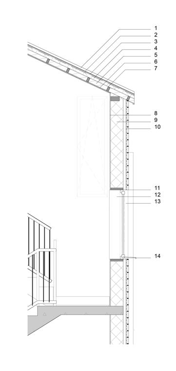
12 13 +13,5+9,0+7,3+4,3+3,0+1,3±0,0-1,0 B Schnitt B 1 100 D 1 Detai 1 50 D 1 Detai 1 50 Kind 01 (W. 08) FlurFlurFlurKind (W. 07) Bad (W. Flachdach07) Küche (W. 07) Kind (W. 05) Bad (W. 05) Küche (W. 05) Bad (W. 03) Küche (W. 03) Flur (W. 03) Rampe (14%) +13,5+11,5+9,0+6,0+3,0±0,0-1,0 2,5 C Schnitt B 1 10 Flachdach Schlafen (W. 07) Schlafen (W. 05) Schlafen (W. 03) Wohnen (W. 08) Kind (W. 06) Kind 02 (W. 08) Wohnen (W. 07) Wohnen (W. 05) Kind 01 (W. 07) Kind 01 (W. 05)Kind (W. 04) Wohnen (W. 01) Wohnen (W. 02) Wohnen (W. 03) Rampe (14%) Abfallbehälterraum 1. Metal sheet (w/ standing seam joint) 2. Breather membrane 3. Plywood facing 4. Timber rafters 5. Thermal insulation 6. Breather membrane wood facing (ceiling) 7. Timber rafters 8. Inner plaster finish 9. Structural masonry (Concrete blocks) 10. Vapor FibrocementMetalThermalmembraneInsulationrafterscalding 11. Dintel 12. Window framing 13. Double glazzing Window 14. Folded metal-Window sill +13,5+11,0+9,0+6,0+3,0±0,0-1,0 Ansicht Nord 1 100 GSPublisherVersion 0.7.100.10 +13,5+11,5+10,0+8,9+6,0+3,0±0,00002 Ansicht Süd 1 100 +13,5+11,0+9,0+6,0+2,9+0,6-1,00 Ansicht Ost 1 100 +13,5+11,5+11,0+9,0+6,0+3,0-1,000052 Ansicht Wes 1 100 D-01 Detail D-01 Elevation North Elevation ElevationSouth East Elevation West Section B Section C

Kalkenhauptstraße
Multistorey Residential Architecture


Apartments layout
Elevation
DF
Glazing ratio vs. Daylight Factor vs. Radiation Perspectives of glazing options glazing 2.1m 2.6m) glazing 1.47m x 2.6m) 1.5% 0.84m x 2.6m) 1.5%
Internal
(openings:
Role: Design, 3D modeling, parametric environmental analysis


-7% -6-5% % -6% NE SWSE NW -19% -18%-14% -17% NE SWSE NW -30% -27%-21% -25% NE SWSE NW -39% -35%-29% -33% NE SWSE NW 30cm10cm 60cm10cm 90cm10cm 120cm10cm Facade
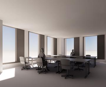
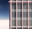
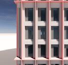
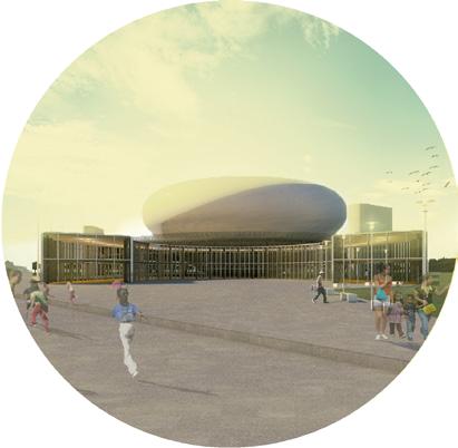
Office Highrise Building
DF 21% glazing (openings:

(openings:
Design: Cityförster & KCAP (Team: Martin Sobota, Piotr Kalbarczyk, Ramon Vivanco)
53%
As part of a winning proposal for the redevelopment of a mixed-use area, an office high-rise building will be erected. The urban ensemble is given certain constraints for the design and functionality in several topics. To be compliant with the requirements, regulations, and design coherence within the new urban area, environmental analysis is taken as starting point to inform the formal decision guiding the facade design. Radiation and daylight factor are the parameters to be analyzed. Through the use of the “Ladybug” plugin for Rhino-Grasshopper, the options and variables are first evaluated to further determine the constraints for the formal parameters to be used in the facade design. Such values are contrasted and tested taking into account the functionality and aesthetics of the building. elements options vs. Radiation


Date: December, 2021
16 17
Location: Bratislava, SK
x
70% floor area above 1.5% DF 37%


Environment Responsive Facade Design


58% floor area above
Type: Commercial architecture
31% floor area above
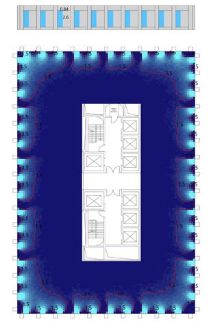
Cooperation: Openfabric Landscape Architecture, Move Mobility

Location: Rotterdam, NL
pecific solutions will range from sloping squares, new vertical cross-views, increased number of entrances, fostering the square as seamless public space, where infrastructure is no-more perceived as separated from the city. The spatial challenge of raising the dike by two meters is turned into an opportunity.” (CF)


18 19
Urban ensamble
Team Cityförster: Martin Sobota, Piotr Kalbarczyk, Isabel Driessen, Annika Brammer, Anaïs Le Grand, Ramon Vivanco
Type: Urban Design
Marconiplein
Date: November, 2021
Marconiplein is a unique crossroad of flows: not only mobility but ecology, water protection, development. The vision for further improvement is rooted in the understanding of this space as a complex node, traditionally devoted to transport and heavy traffic. The proposal aims to shift the paradigm of Marconiplein as a vast space - a collection of several leftover spaces - defined by infrastructures, towards a high-quality public space where infrastructural strategy flows around in a safely manner. The design of the new square will be led by the principle of unveiling. If in history, infrastructures - considered as a major source of disruption - have been buried, hidden and elevated, technological progress and accurate urban solutions, offer now the opportunity of reconnecting to infrastructures. Specific solutions will range from sloping squares, new vertical cross-views, increased number of entrances, fostering the square as a seamless public space, where infrastructure is no more perceived as separated from the city.
Dyke upgrade in a complex urban context
Masterplan
“The design of the new square will be led by the principle of unveiling. If in history, infrastructures -considered as a major source of disruption- have been buried, hidden and elevated, technological progress and accurate urban solutions, offer now the opportunity of reconnecting to infrastructures. S


Stretegy 01
Stretegy 03
Supervisor: Galina Segarra
Ease transitions from surrounding areas. Prioritize non-motorized traffic and implement pedestrian safety Characteristicmeasures.lighting in public space to highlight and define the leisure district.
Leisure District
Date: 2018
Reading between lines
Type: Academic project, Bachelor Degree Thesis
Nature integration to enhance climate control and comfort. Smooth transition toward river Natureside. as landmarks within the IntegratedStretegyarea.02visual identity and traffic safety features. Better lighting and sitting areas for small groups, keeping openings towards public space and storefronts.
The research aims to analyze the usage and ways of occupying the space in the leisure district of the mid-size city of Loja. The analysis seeks to provide information that helps to define strategies and scenarios that allow the necessary arrangements to improve the public space of the sector as an essential part of the city. The study seeks to determine the way of production of space and the mutual influence that exists between the occupied space and the residents. The context is analyzed from the physical (natural and artificial), social (demographic and forms of experiencing public space), economic and normative perspectives.


Author: Ramon Vivanco
20 21
Place: Loja, Ecuador
Perception Survey. An in-situ survey showed that most of the analyzed sites are perceived more negatively during night hours, despite being the most intense hours of use.
ScenariosThespacesyntax
network analysis demonstrates that the main roads of the area have a high potential for integration and accessibility to the street network. Similarly, the routes with the highest integration values are those with a greater presence of people as well as positive user-perception values.


Photography interpretation. Counting people
Kernel Map. Intensity of use
The neighborhood, is a product of population growth and the expansion of the city. Although it was conceived as a residential neighborhood of low density and low land occupation, it is characterized as the meeting point for young people around the central
Scenario Type A. Open space/light plaza


Prospective Scenarios. Finally, intervention scenarios are proposed as a critic, focusing each action towards enhancement of the experience of the public space as a place of cultural and social exchange.

Scenario Type B. Main space/water plaza
Site Observation. From the site observation and user counting at this location was possible to identify a type of user, how people experience the space, areas of concentration, and the hours of most intense use.
Situation
InitialVGAVisibilityD.
Analysisplaza.
22 23 PresenceMaxMinChoiceA.C.IntegrationB.Conectivity
Scenario Type C. Security space/entrance plaza

Place: Gera, Thuringia, Germany
Master Course: 1st semester, Integrated Urban Development and Design (BUW)
Urban Elements in direct relationship with Zschochernplatz.
ThroughAnalysis
5. Street furniture, for seating and shading.
Gera, a former textile city, nestled in the Weiße Elster River valley (Thuringia region). is a city of charm, recognized for its art, culture, greenery, sports, history, and architecture. After the reunification in 1990, the city lost all of its administrative power causing an economic downfall and infrastructural collapse, resulting in a majority of the population (especially a significant amount of young population), shifting to nearby big cities for better job opportunities and lifestyle. Located in the central area of the city, Zschochernplatz can play a role as an important place of congregation and interaction. Lack of activities in public squares and plazas has become a matter of concern for the city development authority of Gera as many of its public spaces lack social interaction and cohesion among people. To provide a suitable alternative to improve such situation, a series of Placemaking methodologies are applied to analyze and design a concept to improve the conditions at Zschochernplatz.
Supervisor: Meg Walker, Project for Public Spaces (New York)
Design Concept features:
PLACEMAKING.Lab
Date: October 2019 - February 2020
The main topics result of the community engagement activities, urban and local analysis were: Public space, Retail, Mobility, Buildings, Ideas (innovation).
1. New pathways allowing for better accessibility for pedestrians and increasing business frequency.
4.place.Installing
Conceptual scenario of Zschochernplatz and connection with Sorge Street.


2. Definition of main zones as part of the design concept for Zschochern, providing flexible usage area for everyone as a destination; focal point and permanent installations and community meeting place with playground.

Type: Academic project
24 25
ZSCHOCHERNPLATZ
Team: Ramon Vivanco, Alicia Sanchez, Biniyam Belete Getaneh, Gabrielly de Souza Lima, Gheyath Mohammed, Mohammad Bodrul Amin, Maya Hörner, Ahalya Vedeparayana Gandikota, Bardo Salgado, Thuy Nguyen, Yuchi Zhu, Marieliz Vega, Dilsad Aladag, Jean Carlos Ocampo, Minseo Kim, Julian Hoffmann, Ping-Yi Hung
3. Each main zone comes with a supportive programme, including an artisans market; food and beverage, seating and physical design elements as a focal point; intercultural exchange space, a playground and a food-serving space as a community meeting
more seasonal plant grouping for a 4-season landscape that is always attractive.
several analysis processes of both physical and social relationships present in the plaza, it was possible to have a better image of the challenges in the urban scale that this public space represents. In most of the cases it was confirmed by the results of the community engagement activities in which the researchers collected ideas, opinions, and perceptions from local population.
2. Diversify cultivation methods
Metabolic-Functional Diagram
26 27
The aim of the project consists in developing a project concept, a flexible tool, and a growth scenario that allows negociation in a planning process where community and urban planners can approach development from a holistic perspective in the context of a rural settlement in Ethiopia. The population rise in Ethiopia represents a challenging task when considering the provision of water access, food, and housing. Agrication City represents one possible development model to carry the rapid population growth for rural Ethiopia while connecting it to an economic prospect. Wurer is one existing rural settlement for which the potentials of education access and agricultural cultivation fall together favorably. The lengthy settlement structure is located on top of a plateau which is also where the main road connects Wurer with near-by university with research activities in agricultural sciences.
Water Treatment
FarmsAgriforestAgric.Crops Tank
Date: April 2020 - July 2020
Type: Academic project
Team: Julian Hoffmann, Ping-Yi Hung, Thi Thuy Nguyen, Ramon Vivanco
Commercial
ForProcessapplying
Supervisor: Vert.- Prof.- Sven Schneider and MSc. Philippe Schmidt
Rain River
Place: Weimar, Thuringia, Germany
the concept of Agrication to Wurer, a street network is generated at first, assisted by a parametric tool to withstand erosion from uncontrolled rainwater. Then, a run-down analysis is carried out. Further, the network is screened for its most active street segments. The street block size goes in accordance with what was found to be locally common for rural areas.

1. Integrate Research, Education and Farming Practice
4. Distribute water infrastructures
Storage
Irrigation
Master Course: 2nd semester, Integrated Urban Development and Design (Bauhaus-Universität Weimar)
SocialKnowledgeFacilitiesTransferMix-useAreaSharedFacilitiesFactories ServiceMarketPoint

3. Distribute agrarian infrastructures
Agrication Ethiopian rural development
A metabolic-functional concept guide the process of allocation of land uses, infrastructure provition and growth logic according to 4 principals:
Land uses are located accordingly. For a more detailed growth scenario and process, several typologies are especified and adapted to spatial constrains.
Technologie and knowhow transfer facilities are distributed within the settlement to ease the access to knowledge and education for agricultural production.
Growth Phase 2:
Growth Phase 2:
28 29 Growth Phase 1:
Distribution Growth Scenarios
LandAnalysisUse


Growth Phase 3:
Growth Phase 3:
Land Use Scenario 000 000500m500m500m 500m500m500m0 500m 0 500m 0 1km


Growth Phase 1:
Main agriculture production areas are identified and complemented with further smallholding farms to be developed. Water access points are located near education facilities.
Agriculture production is expected to be diversified. Shared storage facilities as well as specialized market places appear to enhance commercial activites and economic development.
The central area can be densified to provide diverse services supporting production, commerce and social activities for residents. In this stage the water network is expected to reach a housold level.


Merketal II, Sustainable Mobility Assessment
Supervisors: Prof.- Dr.- Sven Schneider, Dr.- Martin Bielik
30 31
The aim of the research is to provide insights for sustainable development of a neighborhood focusing on the assessment of mobility and accessibility, by doing so it seeks to develop scientific approach for solving a design challenge. The case analysed is Merketal II, in the city of Weimar. Since early-stage decisions have a great impact on urban infrastructure and conditions how people navigate the city, it is relevant to provide research-based analysis to inform the planning process.
Traffic Flow model, Weimar Betweenness Centrality R=0
Type: Urban mobility and accesibility assesment

MSc. Thesis
Date: December, 2021
Location: Weimar, Thüringen, DE
Utilizing a traffic model, several scenarios of possible connections are compared to inform the main trade-offs depending on factors such as population and integration to the street network. Furthermore, a walkability analysis helped to inform about the potential for the development of the site to encourage non-motorized mobility to access services. The street network analysis, with two approaches: traffic planning, and space syntax, has proven to be closely related to accessibility for both traffic flows and walking routes.
Weimar Land-use overview LandscapeCementeryIndustry and commercial AgricultureMixedPlaza Residentialuse Water bodiesLegendRailroad ForestSpecial function Sport and recreation 2km0
32 33
Scenario 3
Scenario Comparative1
On the other hand, a walkability assessment informs about the relationship between walking distances and the access to services in the area. By means of a weighted network analysis using location of services as “walking destinations” as proposed by Bielik, et al. (2018), it is possible to identify the degree of walking accessibility for the project’s neighborhood.


Average walking atractivity per segment
traffic model scenarios
The walkability analysis is carried out with the segments close to the analysis area, taking as a reference the isochron of 15 minutes walk to analyze the gravity-centrality (accessibility measure directly propotional to actractivity and inversely proportional to distance) with the DeCodingspaces plug-in (by DecodingSpaces GmbH) for Grasshopper. In a later step the average values per segment are calculated to provide a unified walkability index.

R=600
The approach towards the assessment of sustainable urban mobility for the development of a new neighborhood consists of a two-folded analysis. One the one hand, a traffic model analysis to evaluate the impact of different density combinations for the area under potential estate development. This allows foreseeing the changes in traffic flows in surrounding streets.
The methodology used for walkability assessment has demonstrated that the site possesses a great potential to access walking attractors, which are well distributed around the area. However, due to the nature of the elements analyzed, mainly geometrical features, other factors can present difficulties for the fulfillment of such potential. For instance, and as previously discussed, the motorized traffic can play an important role in walkability. Therefore, urban design and traffic calming measures will be important aspects to be considered for the development approach undertaken in this area.
Services, location and connection to street segmentsBetweenness Centrality
Scenario 2
The potential of walkability that Merketal has can be inferred from the results of the analysis of the weighted betweenness centrality and the result of walkability. Even though the betweenness centrality analysis sets the trend for the street network, the street segments with higher values of walkability reveal slight changes in such patterns. The implementation of services, even with a local scope, may increase the probability of walking for the population at the neighborhood level. However, design measures and strategies aim to ensure safety, environmental quality to increase non-motorized mobility, especially in the main areas of access to services.


*Award: Gold Medal for Academic Projects, Bienal Panamericana de Arquitectura 2018, Quito-Ecuador
Type: Academic project
Manglar Ecological Machine
Place: Guayaquil, Ecuador
Supervisor: Kenny Espinoza Carvajal
Date: 2017
TheBackgroundproject requires the development of a transformation and permeable urban reconstruction, defining it as the opportunity to relate the landscapes of the territory with minimum alteration, allowing people to learn to live with risk. This implies applying strategies that improve the capacity of the urban structure, which can cope with the destructive effects of future events such as floods, that impel progressive processes of transformation.
34 35
Resilient cities - Mangrove recovery
Team: Ramon Vivanco, Carlos Macas, Mary Cueva, Jessica Peña, Evelyn Robles, Tatiana Caraguay, Nathaly Gahona, Edy Jaura, Dolores Cevallos, Hugo Jara, Germania Cuenca, Carlos Valarezo, Cindy Morocho, Michelle Rojas, Julia Herrera, Estefania Sanchez, Ronald Días.

PLANTA SEMILLA E = 1:100 TIPOLOGÍA A PLANTA SEMILLA E = 1:100 TIPOLOGÍA B PLANTA CRECIMIENTO E = 1:100 TIPOLOGÍA C Y DORMITORIO PATIO/PORTAL ACCESO X X YYY X X DORMITORIOBAÑOCOCINA/COMEDORCOMERCIO/HABITACIÓN 2 4 5 1 USO DORMITORIOVARIO X DORMITORIOUSODORMITORIOCOCINA/COMEDORCOMERCIOVARIO 4 BAÑOAMPLIACIÓN ACCESO X X 1 728 HALLCOCINA/COMEDOR16 USO DORMITORIOVARIOBAÑO7 DORMITORIOACCESO URBANOCRECIMIENTOYDIVERSIDAD Housing. Height+Diversity


Housing: Autoconstruction, Evolution, Production


Urban Equipments/ Resiliency Devices


Through several pieces of equipment ranged on the urban scale, it is aimed to serve as purifiers, flood-controllers, and transition between the urban and the mangrove area. The functions of the equipment respond to an urban scale to give the neighborhood an urban relevance to enhance its identity and importance as part of the city.
The morphologies of such urban devices correspond to certain morphological properties taken from liquids interactions to make a soft border that contrasts and also fits this unique environment.


Urban Equipment. Resiliency Devices
The housing project implies a growth logic under auto-construction parameters to host productive activities as well as private/ residential settings in combination with social interactions typical in the culture of the district. The concept of the housing development is to provide a structure in which people can have the opportunity to modify them in the provided frame. As the families grow in number and age, they also evolve economically, which allows them to modify their housing units.


38 39
Urban Scenario
Concept: Resilient Development
The recovery and reactivation of the border, changes in the urban fabric, implementation of a sustainable city model, architectural solutions such as the construction of resilient or stilted typologies, and replicable devices on the edge as purifiers and refuges connected to the city through efficient mobility routes.

The areas with the highest incidence of projects in different areas are identified. A balance of development in this rural-urban region is clear as the intention of the macro project. The implementation of projects presents marked concentrations that seek to reactivate, intensify and innovate to stimulate the local economy and collaborative relationships between cities in the region, especially the urban-rural relationship.
Type: Regional Planning
*Internship at DeZwarteHond, Köln-Germany
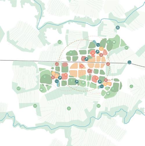
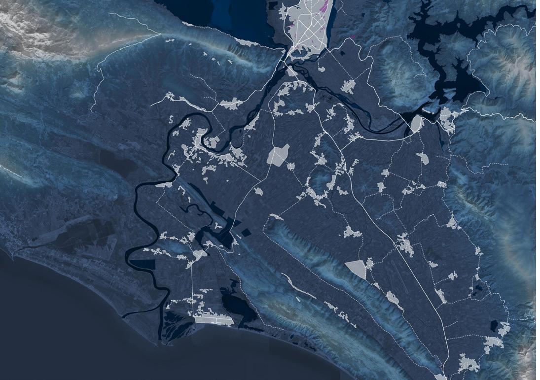
D.- Landvoran: the most rural areas of the region where exchanges are carried out mainly internally, where daily transfers for work reasons decrease the number of population during the day and population and construction densities are relatively lower than those of the aforementioned areas. previously.
Regional development perspectives
Ostwestfalen-Lippe Raumbild
C.- Lokale Magnet: Paderborn, being an important city in the region and somewhat disconnected from the urban centers that are connected as described in the Perlenkette area, represents an attractor to and enhancer of the nearest towns.

Team DeZwarteHond, Köln: Matthias Rottmann, Johannes Langer, Ramon Vivanco
Regional Typologies and Synergies
From this analysis it is necessary to identify the main strategies of the regional development project as well as the interactions and communications that the projects have with the region and with other projects.
40
Date: March, 2021
Location: Ostwestfalen-Lippe, NRW, DE
Four areas can be highlighted as a result of the analysis of urban areas:
OWL Raumbild
A.- Perlenkette: a dense urban axis with a greater presence of industry, commerce, and transport connections.
B.- Partner auf Augenhöhe: areas of exchange and synergy of medium-scale cities for the region, very close to the strongest urban areas.
Forest
ThisIntroductionproject shows the synergies and interrelations of various projects at different scales, approaching potentials and opportunities existing in the territory of Ostwestfalen Lippe from a regional development perspective. Besides identifying the individual qualities of different projects their scope of influence is discussed, showing how far those can fulfil an integrating function within a regional planning framework.

the current status of projects along with their location and relations to the territory and other projects, one can understand into which direction the development of the region will orientate for the future and also communicate that perspective.
TheAnalysisgeographical characteristics of the region contribute to the diversity in the natural and cultural landscape. The mountainous areas and low areas along with the rivers of the region make this area an important tourist destination. Aspect that stands out and strengthens with regional development projects.
42 43 Settlements Agricultural Land


A stringent communication of the stepwise implementation of projects is supportive for the planning team to open a dialogue on the current status of the regional project. It helps to understand the overall goals and builds consensus among stakeholders, decisionmakers, and the civil society. This enables further adjustments to an ongoing regional planning process.
ByProjectsareasconsidering
Centrality R=n Centrality R=1200

Network analysis

44 45 Mobility hierarchyCommuters: arriving
The analysis of the mobility network Represented by a 4-level road hierarchy shows general connectivity well distributed with higher densities near large cities and cities along the most urban axis of the region. The most important connections of the region with the closest cities and regions are with Hannover to the northeast, with Göttingen and Kassel to the southwest; with Osnabrück and Münster to the northwest and west, respectively.


According to the spatial syntax analysis, the centrality of the region is concentrated around Bielefeld extending along the axis of the A2 and also towards Paderborn and Detmold. The most peripheral areas of the network correspond to the south and southeast areas in the steepest part of the region. Regarding local centralities, the result of the eligibility criterion at 1200m, well-marked centralities stand out in denser urban centers and few incidents coincide with smaller cities. However, the pattern once highlights the proximity of concentrations along the aforementioned axes.
BielefeldPaderbornDetmoldMinden

46 47
Settlementsregime.and
Dam UrbanBeachArea
Flood Prone Areas
Flood Risk Management
Date: December, 2021
Infrastructure. Territorial Overview
Cooperation: Deltares
Polder Areas
Ongoing Project Locations
Team Cityförster: Martin Sobota, Raxhina Basha, Ramon Vivanco
The largest (perceived) flood risks come from upstream dams. Changes in hydrology from human activity, climate change, and previous settlement and land use could increase the potential risk of fluvial floods.Various projects in the city are being implemented, none in the delta area (while most affected area).


River
Rediscovered old rive basin
Increase drainage capacity for the river to give ‘Room to the River’ and further propose it as a site with touristic potential for development of a sustainable touristic business model that considers full range of water management for both droughts and floods.
At the outflow of the river in the Mediterranean Sea, a delta has formed, which is highly dynamic. The river mouth is periodically silted up. The principal threats to the site include land reclamation through drainage, development for agriculture, and changes in the water
Surface water flooding can be caused by the increased volume of water due to extreme rainfall events that can overwhelm the river discharge capacity and existing drainage systems.
Different potential measures were identified through a field visit, where it was found that the River has partial embankments (27 km on the eastern side), which did not prevent the floodplain from inundation in 2010.
In an international collaborative endeavor to develop and implementation of sustainable water management projects, architects and municipalities came together to assess the potential for sustainable projects in the region. Hence a quick scan aims to explore project leads and their potential for funding and realization, plus start a co-creating process with local stakeholders.
Type: Regional Research
A quick scan
48 Ramon ramon.1369@gmail.comVivanco+4915201384182