RELOCATION OF VILLAGES FROM PROTECTED AREAS
ii
iii
iv


A dissertation submitted in partial fulfllment of the requirements of the degree of Bachelor of Architecture by Rahul Gujarkar 1824 Supervisor Shantanu Poredi
Kamla Raheja Vidyanidhi Institute for Architecture and Environmental Studies Fi h Year 2022-2023

I, Rahul Gujarkar, declare that this written submission represents my ideas in my own words and where others’ ideas or words have been induced ,
I have adequately cited and referenced the original sources. I also declare that i have adhered to all principles of academic honesty and integrity and have not misrepresented or fabricated or falsifed any idea/data/fact/ source in my submission.
I understand that any violation of the above will be cause for disciplinary action by the institute and can also evoke penal action from the sources which have thus not been properly cited.
Name: Rahul Gujarkar
Signature:_____________
Rollno: 1824
Date:
Thesis Approval for Dissertation for B.Arch Thesis
This thesis / dissertation/ project report titledRelocation of Villages From Protected Areas,
by Rahul Gujarkar is approved for the Degree of Bachelors of Architecture.
Date: _____________
Examiner 1: _______________ Examiner 2: _______________
I am grateful to those who made this journey an opportunity for introspection and self-discovery. I begin by expressing my gratitude to my mentor, Shantanu Poredi, who inspired me to recognise the signifcance and originality of my project.
This project wouidn’t have been posible without the support of Mr. Ramzan Virhani, who shared his thoughts and expertiese on this unique topic.
I also want to thank Aishwarya Padmanabhan for helping me organise and write up all the research. The panel, Rutika Parulkar and Ankush Chandran, whose suggestions helped me make this book useful.
To Sarvesh Wanode & Rohit Jawarkar to be prepared on foot to help me during my arduous and extensive site visits
No one could have completed this semester-long journey of selfdiscovery without motivating friends. My friends Sarthak Malunde, Soham Jamdar and Ashwani Kumar were kind enough to keep me company late at night as I worked and helped me refne my ideas.
To my parents, who always went above and beyond to assist me when I was in need

In India there are a lot of remote villages that could be found in the core or buffer region of a protected area, and humananimal confict is bound to take place from both sides. There are numerous incidents reported about attacks, but sometimes they are found to be fctious . On the other hand, poachers take advantage of the fact that the village is situated within the protected area and team up with villages to poach animals for meat and various other reasons.
As hinted earlier these ‘remote villages’ have very limited connection (transport & technology) from the districts or talukas which at times causes multiple problems for them. The older generation couldn’t care less for all these issues as they have lived their whole life that way but the younger generation, who is more technologically educated, aspire for all these benefts.
Village relocation from protected areas is a voluntary decision taken by the villages after a lot of deliberation with the government and eventually they are given monetary compensations or they could opt for a fullfedged village rehabilitation according to the government regulation.
Citing the case study done of tipeshwar and moregaon village, which had been relocated from tIPESHWAR WILDLIFE SANCTUARY , one can clearly see the village and the dwellings were deeply being infuenced by various factors like caste, class, occupation, topography, roads, etc. and had evolved over a time of time.
The thesis at frst addresses and assesses the post relocation condition of villages. As the inception village/community takes place over a period of time and keeps altering over time as per various factors like social structure, festival & rituals, daily life, art, built spaces etc. which I refer to as the ‘spirit of a village. This whole process is skipped when a village is relocated within a year.
In current situation, none of there factors or ‘the spirit of the village’ is acknowledged. The rehabilitation takes place according to a generic government order which is same for a village in kokan region and a village in central india. Second aspect of the thesis, would be how to address this spirit while laying the foundation of the village in a new location. And differentiate between ‘relocation’ and ‘rehabilitation’.

India is well known over the world for its wildlife diversity which ranges from mountainous rain forests of assam to tropical forests of central India. over the last few centuries, under the british rule, these forests and wildlife have been continuously exploited. Exploitation in terms of deforestation for timber & land and killing of animals for various reasons like meat, leather and even entertainment. And eventually the condition began to worsen, there was a need for new regulations to curb these problems. In 1972, the Indian government passed the ’Wildlife Protection Act’.(wpa)
The wpa was an act passed by Indian government in 1972, citing the degrading condition of the Indian forests and wildlife. According to wpa the state government may, by notifcation, declare its intention to constitute any area as a sanctuary if it considers such area is of adequate ecological faunal, foral, geomorphical natural or zoological signifcance, for the purpose of protecting, propagating or developing wild life or its environment.
There have always been villages and tribes who stay within or are dependent on the forests but once an area is declared as a sanctuary their ownership rights come into question.
In such a scenario the people living within the protected area can claim the right to ownership of the land in the notifcation within two months. Further they can claim the ownership of the land and if accepted,are provided with fair compensation.
A major chunk of these villages comes from collecting and selling forest produce. Specifcally in central india people collected things like tendu leaves, herbs, dried grass, bamboo etc. but, after the implication of laws all these activities were termed illegal. Though they are allowed to collect minor forest produce for personal use,but a large quantity in possession could attract legal action from the forest department.
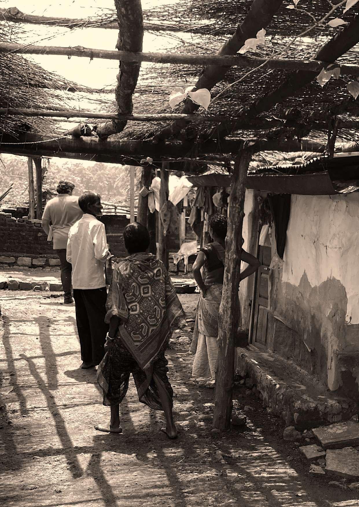
The villagers are not that intimated by the legal action and the jail time they might have to spend. But are agitated by the frequent trips they need to take to the sessions court located in the nearest taluka which at times is far and diffcult to access. Pitapongari village, located within tipeshwar wildlife sanctuary, is almost 50km from pandharkawada taluka. Out 50km almost 9km is dirt road within the forest boundaries which are inaccessible by motor vehicles once it rains.
-Laxman Tekar, Patil of Pitapongari village
“If rehabilitation is bound to happen, the villageness of my village should not be lost”
Though the village is termed as a tribal village, they have been affected by urbanisation and globalisation, And the gap between rural and urban is seemingly reducing. Earlier these villages were an economy within themselves but things change when they start to connect to urban regions. The villagers are dependent on numerous farming grants given by the government, but they aren’t able to take full advantage, going to taluka every few days to follow up the process. The so called “tribal” villages now own motor bikes, which need petrol and frequent maintenance and smartphones. They are kind of always in some sense connected to urban areas but still physically disconnected.
Rehabilitation is a long and time consuming process as a lot of deliberations take place. It takes a big mental and physical toll on the people relocated. Whatever the conditions may be, when the government asks people to leave a place where they have spent more than half of their life, some resistance is bound to take place and hence the process is prolonged.
But relocation is not a sure short solution to all of the villagers’ problems. Every adult villager, with some implications, is considered a separate family and is compensated individually. Post relocation case study of ranbodi,moregaon and tipeshwar village which were relocated in 2018, 2012 and 2008 respectively according to option two ,observations can be made, how the living condition changes over a period of ten years. A signifcant observation was that the villagers were more aware of their rights and could negotiate a better deal with the government as time passed.
Inception of a village takes place over a span of time from node to node and street to street according to the necessity . And when relocated, this process is bound to be skipped. The study would address similar factors in order to fnd what is exactly the “villageness” Mr. Tekar was referring to. Also the study intends to analyse the villages rehabilitated at different times. Analysis of what benefted the village and what problems they are facing.
As stated by Mr.Ramzan Virhani,”In this whole arrangement, there are two kinds of people, the socialists who are only concerned about the people and the others, the wildlifers who are concerned only about the wildlife”. In the case of socialist, they do not want the village to be relocated but want the government to make all the facilities available to them. And what wildlifers want is ‘relocation’, that is they are not that concerned about what are immediate as well as long term effects of this on villages.” Hence it can be inferred that villages need to be rehabilitated and not relocated.The study would intend to make recommendations for village ‘rehabilitation’ and not village ‘relocation’ considering both the wildlife and social aspects.

The investigation into village relocation from protected areas was broken down into the following stages.
1. To comprehend the relocation process, particularly when relocating from protected areas.
Villages are relocated forcibly as a result of highway, dam, or other government projects, and they have no choice but to leave the area. In contrast, relocating a protected area is a choice made voluntarily.
2. Research and data collection in the form of frst-hand information will be done in order to ascertain the various factors infuencing a person’s daily life in rural India.
3. In order to compare and analyse both the positive and negative effects that relocation had on the villagers, the third stage would attempt to create a matrix of villages before and after relocation.
In the book ‘National Parks of India’ by R.S. Bisht, the chapter ‘Man Vs Wildlife, The author gives an overview of how the interaction between wild animals and the people surrounding these areas have changed over the course of years.
According to the author, the causes for this man-animal confict which is leading to ecological crisis are as follows First, there has been a dramatic rise in human population and increasing demands for land, which are destroying and limiting wildlife habitat. Clearly, habitat degradation causes wild species to diminish and imperils their ability to survive. As a result of the decrease in animal habitat, there is increased competition among animal species for food. As a result, animals leave the bounds of forests in search of food and wander into human areas, harming their crops, killing their livestock, and occasionally even killing people.
The second cause of confict between people and animals is this kind of wild animal behavior. Crop protection gained far higher emphasis in a nation that was not selfsuffcient in food regarding animals and its environment. Large tracts of forest were removed and put under cultivation when the country gained its independence in order to increase food production.
On other hand crop raiding animals, both old and new, were eliminated from cultivated regions. Gun permits were readily distributed to farmers in the guise of crop security, and these growers used the weapons not just to shoot crop-robbing animals but also against defenseless animals in their natural habitats.
The third reason for man-animal confict is attributable to the culture of consumerism and ostentatious lifestyle of people in modern society. On the one hand government has been undertaking ambitious projects of mining and constructing big dams and roads in the forests and damaging fragile ecosystem for short-term economic gains and on the other valuable timber and animals whose body parts fetch exorbitant price in the international market are being harvested by smugglers and watchers to satisfy their insatiable lust for money. These reasons are not exclusive to each other but could overlap and be incomitant. The crucial and moot question is how to remove these causes of ecological crisis.
The creation of a national park may enrage the populace, making them antagonistic to the park’s administration. It is shown by the fact that the Nanda Devi National Park is no longer open to the general public and that locals are not permitted to graze their animals there.
From the beginning, local residents were completely shut off from the park’s security programme. They were denied the opportunity to pasture their sheep in the park.
As a result, they were forced to sell them off and incur a fnancial loss. They also lost the money they made working as guides and porters because the park’s tourism was also outlawed. Additionally, they were unable to get the frewood, grass, mushrooms, and medicinal plants they needed from this region as they had done in the past before it was declared a national park. These individuals feel duped and see the park as a danger to their basic survival as well as the Forest Dept. as their enemy because they were deprived of the cash from conventional concessions and privileges that they had previously enjoyed. Such unhappiness among residents of parks or those who live near them completely alienates them from the conservation programme and the park administration, and it does not augur well for the country’s ecosystems’ preservation.
Similar situations of people and tribal communities living in protected areas were described in a newsletter released by All India Forum of Forest Movements. It describes stories of tribal villages in central India from the state of Maharashtra, madhya Pradesh and chhattisgarh and how relocation affects the people.
It is obvious that there is still governmental prejudice against both tribal and non-tribal populations that live in forests. The forest administration continues to treat forest communities in the Protected Areas visited during the forest communities in the
Protected Areas visited during the factfnding missions that formed the basis for this publication as just “disturbances” that have to be eliminated in the sake of protecting wildlife. The so-called conservation efforts in the Protected Areas ignore the FRA and are blatantly in violation of it, alienating indigenous forest populations from their land rather than recognising their legitimate and historical contribution to conservation.
The lack of adequate livelihood opportunities for the communities is the main problem in all Protected Areas, which is relentlessly exacerbated and made worse by frequently illegal offcial restrictions on the use of forest products, forced or involuntary relocation, and, fnally, displacement without fair compensation for those who are displaced. In addition to these direct threats, communities inside forests designated as Protected Areas also face indirect threats from vested political and economic interests that seriously jeopardize the livelihood of thousands of people living in and around the Protected Areas, such as extractive industries, other development projects taking place nearby, illegal logging, and unrestricted tourism.
As people continue to struggle to enjoy their customary rights, to the use of forest produce, the quality of FRA implementation in Protected Areas has likewise been routinely extremely bad. Primary documentation of the reasons and problems in the Protected Areas, as well as accurate collation of the required records, are particularly crucial since in many places a lack of paperwork has impeded the communities’ ability to survive and thrive.

The following chapter discusses the processes involved in declaring an area as protected area and relocations of villages within the prescribed area. Fig 4 image of tiger from TATR: Author
During 1970s, due to tremendous pressure from hardcore enviromentalists and wildlife enthusiasts to set aside inviolate spaces for the exotic species, tiger reserves were created. In this process the people who were affected were never consulted directly. Nor precautions were taken to ensure that the cost of such reservations did not fall disproportionately on people living in and around such protected areas. Ever since, this has been a major reason for conficts between the advocated of human rights and the environmentalists. If in the interest of at large, it is decided to keep aside a small percentage of country’s land area for ecological considerations, the decision is not likely to be contested. But this may require a very different set of arrangements of benefts and cost sharing as compared to what prevails today.
Wildlife Protection Act (WPA) was an act passed by Indian government in 1972, citing the degrading condition of the Indian forests and wildlife. According to wpa the state government may, by notifcation, declare its intention to constitute any area as a sanctuary if it considers such area is of adequate ecological faunal, foral, geomorphic,natural or zoological signifcance, for the purpose of protecting, propagating or developing wild life or its environment.
There always have been villages and tribes who stay within or are dependent on the forests but once an area is declared as a sanctuary their ownership rights comes in question. In such scenario the people living within the protected area can claim the right to ownership of the land in the notifcation within two months. The collector has to either refute or accept their claim, if accepted, the procedure of surrender of land should begin within two years, in which an appropriate compensation is offered.
If the conditions of the designated region satisfy the federal government, it may be declared a sanctuary or a national park by notifcation. If the federal government is satisfed with the requirements listed in section 35, it may declare sanctuaries or national parks.
Communities have been moved from protected regions for decades but without much success up until fve years ago, when a noticeable change occurred. The National Tiger Conservation Authority’s radical revamping of the relocation procedure since 2008 is the primary cause of this (NTCA).
Up until 2008, a household living in the forest would receive Rs. 1 lakh in cash and land for land at a mutually agreed-upon alternate

site, which was typically found in the tiger reserve’s buffer zone. The amount covered the price of a home as well as the portion of costs incurred by each household to build a shared civic infrastructure. Each residence, even in the case of mixed families, was regarded as one benefciary unit, and no compensation was granted for the lands forfeited.
The Union Ministry of Environment and Forest land & Forest Department had enough money in 2008 after the NTCA was established. As a result, individuals who were ready to migrate without looking for land at the new site received 10 times as much money as before. The second option was fve acres (two hectares) of land at the relocation site and monetary compensation of Rs. 10 lakh, of which one-fourth would be given as cash in hand to construct a residence and the remaining money would be used to develop civic facilities
The Maharashtra government added an additional advantage in 2015, and it is now available to everyone at all NTCA relocation sites. For the lands given up by people who chose not to start farms at the new location, the government compensated four times the land value.
The original defnition of a family unit was any male member over the age of 18. Only in Maharashtra were unmarried women over 18 included in this amendment in 2013, thanks to the continuous efforts of Praveen Pardesi, the state’s then-forest secretary. In addition to increasing compensation, the NTCA also offers advantages like subsidies for gas cylinders, which spares residents the trouble of gathering frewood from the forest, and solar fencing for farming at the moved location.

.There are two elected bodies, the EcoDevelopment Committee (EDC) and the rehabilitation committee. The EDC seeks to raise environmental awareness and recommend development that is favorable to forests by fostering innovative, participatory solutions. The rehabilitation committee, which communicates the needs of the community to the bureaucracy, is made up exclusively of villagers. It was established at the time of relocation to serve as both a village-level self-administrative body and to carry out the restoration process. Once the procedure is fnished, it is dissolved.
The head of the navegaon village’s rehabilitation committee, Azhar Sheikh, said: “Jammi inhabitants acquired courage
Fig 6 illustration of village meeting: Authorto move out looking at our shift.” One year after Ramdegi, fve other villages in the TATR’s main area—Jamni included—moved. Sheikh is a middle-aged man. He hails from a reputable family from the neighboring village of Khadsangi, which is outside the buffer zone and is much larger, more established, and more diversifed than Navegaon. Compared to the residents of Navegaon, who generally interacted only with the Forest Department, Khadsangi has a far lengthier association with the other branches of government, such as irrigation, revenue, and agriculture.
The people of palasgaon singru are happy but it is tucked away in the forest amidst huge open areas and has 60 families and 138 acres of farming. The locals still craft bamboo mats and baskets. Koichade, a resident at palasgaon singru claimed that while they spent a day in the woods to chop the bamboo for the baskets, they created 10 baskets a day and sold them for 50 rupees apiece. Their earnings buy a week’s worth of rations. The majority of the remaining family have sold their land to non-forest residents who farm it in the same community as agricultural labourers, with the exception of fve families who still hold tiny parcels of land.
The Scheduled Tribes and Other Traditional Forest Dwellers (Recognition of Forest Rights
Act, 2006), also known as the Forest Rights Act, states that it is forbidden for non-tribal people or anyone other than “traditional forest dwelling communities” to own forest land, but this hasn’t stopped a number of such deals from happening. Tribal populations have been driven into poverty and forced to engage in unlawful land deals due to their isolation, dwindling markets for their produce, drought, and animal damage to crops.
As a result, both they and the forests are more vulnerable to exploitation. Even though they are aware that life will never be the same again, the residents of villages situated in the middle of a protected area cooperate when it comes to rehabilitation.
There are two broad types of compensation packages the government offers.
1. The golden handshake: Residents of the village are given a one-time compensation in exchange for leaving the old village, after which they are free to relocate anywhere.
2. The relocation: In addition to monetary compensation, the villages are offered a plot of land per family in a brand-new village being built elsewhere.but the monetary compensation is signifcantly low as compared to golden handshake.


The following chapter discusses how six villages from Tadoba Andhari Tiger Reserve waited over twenty years to relocate after the development was stalled by the government.

The frst notice for Tadoba sanctuary, covering an area of 116.55 square kilometers, was given by the Bombay Presidency during the colonial period in 1931, and it was converted to a national park in 1955. At the time, the area indicated in the announcement included two villages, Khatoda and Pandharpauni, which were moved, possibly forcefully, on the park’s outskirts. Tadoba was one of independent India’s original fve national parks, and they may have been the frst animal relocations since the country’s independence in 1947. Tadoba has been excluded from all future development plans since its designation as a national park. .Since 1968, the collecting of non-timber forest produce such as gum, mahua fowers, thatch grass, tendu leaves, and so on has been prohibited. The reserve area was expanded to become the Andhari tiger sanctuary in 1986 to create a buffer region for Tadoba national park, totaling 509.27 square kilometers.
Since then, six communities, namely Jamni, Nawegaon, Palasgaon, Rantalodhi, Botezari, and Kolsa which lie inside the notifcation area have been fnalised for relocation. Meanwhile, the Maharashtra government had put the entire region under the Tadoba and Andhari Tiger Reserve (TATR) after gaining consent from the national government. In terms of rights, this is a critical milestone in the timeline. With the region being proclaimed a ‘tiger reserve,’ a variant of a ‘national park,’ it now has legal protection under the WPA (1972). All previously granted rights and concessions were revoked. In the instance of TATR, rights to harvest minor forest produce, including tendu, were suspended in 1992, nearly three years before the reserve was declared a tiger reserve. Currently, collecting of fallen trees for frewood and limited grazing are permitted in the sanctuary region but not in the national park area
Since 1986, the six villages of Jamni, Nawegaon, Palasgaon, Rantalodhi, Botezari, and Kolsa had been awaiting relocation. All development efforts in these regions have been halted since the decision to transform the area of communities into pastoral land for the sanctuary was communicated to the villages. These include modest building works such as culverts, which are required to channel rainfall, as well as the provision of primary health care facilities and fair-priced businesses. The forest department, the villagers’ sole source of employment, has ceased operations since the sanctuary’s designation and in accordance with the statute.
During the monsoon season, almost all of the six villages were inaccessible; none of the villages had a tarred road link; and only Kolsa had a post offce and a primary health centre. Only two of the six settlements had access to state-run buses, and only fve had an intermittent supply of power. In the case of these communities, the market was around 10km to 30km away, requiring a distance to be completed on foot or by bullock cart for any purchase ranging from salt to clothes.
Around 19.4 percent of yearly revenue comes from legitimate sources such as farming and cattle raising, 8.5 percent from illegal bamboo and wood poaching, and 72.1 percent from collecting forest goods such as fodder, fuel, herbs, wild vegetables, fruits, and nuts. Unfortunately, because the resettlement package does not acknowledge resource usage, it is not seen as a loss to the locals.
The rehabilitation of the six villages is still incomplete, with Ratnalodhi standing as the sole village inside the region.
The rehabilitation of the six villages is still incomplete, with Ratnalodhi standing as the sole village inside the region. The forest service has just lately begun the relocation procedure seriously. The union government provided cash to the department as part of the relocation package in 2005. Botezari was the frst hamlet to be evacuated to Kaislaghat, which is in the Chandrapur district and about 50 kilometres from the present village location. The Forest Department Corporation of Maharashtra (FDCM) has given 550 hectares of a patch of 1100 ha to FD for relocation.
Four settlements already exist in this region, and they have been de facto utilising the forest owned by the FDCM. With a portion of the forest removed for relocation and no option for satisfying demand for fuelwood and fodder, the strain on the remaining FDCM-owned property will intensify as additional people move in from TATR. The authorities have completely ignored this element. Instead of removing such a large tract of land with little vegetation, a location near a forest region (but keeping forest-dependent populations in mind) may have been chosen.The people were offered a choice of other locations, and according to the forest department, the kaisalaghat site was chosen since it was close to a forest area. However, with the clearance of half the forest, the purpose has been defeated.

 TADOBA ANDHARI TIGER RESERVE
JAMNI PALASGAON RATANLODHI BOTEZARI KOLSA
TADOBA ANDHARI TIGER RESERVE
JAMNI PALASGAON RATANLODHI BOTEZARI KOLSA

Decoding life in rural India
“Such sociological facts and principles derived from the study of rural social relationships may be referred to as rural sociology”.
-T.L. SmithFig 9 image of discussion in patapongari: Author
As the name suggests, rural sociology is the study of rural society, rural social structures, and rural institutions. Since agriculture is the mainstay of rural society, peasant society is another topic of interest for rural sociology. The focus of rural sociology is on rural communal life. The social structure, procedures, social dynamics, and social control in rural society are signifcantly different. Therefore, researching rural society differs from studying urban society; rural sociology focuses on the latter. As a result, rural sociology is a systematic study of the many aspects of rural life and has been specifcally created to investigate rural phenomena. For the smooth operation of society, it is the study of rural social networks and how they function. The majority of rural society is based on the villages, and rural sociology investigates the aspects of the villages, how they operate, the issues they encounter, and how they respond to impending challenges. The study of rural sociology provides workable remedies and preventative measures for the issues that plague the villages.
The focus of rural sociology include research on rural social institutions such as caste, marriage, and the family system, as well as rural social change such as migration and newer livelihood options, rural community, rural education, rural urban comparison, and rural health. But urban bias has long been seen among scholars and researchers who have previously concentrated their attention on the study of phenomena and diffculties in urban life.
According to A.R Desai, “the study of the Indian rural society, which varies from state to state, district to district, due to their extreme geographical, historical and ethnic peculiarities, hitherto made has been spasmodic, insuffcient and often superfcial”. He further states that, “such a study cannot give an authentic, composite picture of the

variegated landscape of the rural life, nor can it serve as a guide for evolving a scientifc programme of reconstruction of the rural society, so essential for the renovation of the entire Indian society”. David Pocock and Louis Dumont contend that there is nothing exceptional about Indian rural life. Both rural and urban groups are part of the subcontinent’s greater culture. They contend that the urban community is simply an extension of the rural community. Rural and urban societies are essentially two sides of the same coin.
Humans were nomadic by nature and had no knowledge of farming or horticulture. They used to travel about for food until he learned agriculture and settled down. By learning about agriculture, they were able to settle in a certain geographical location and no longer needed to roam. As they discovered rich area for farming, numerous people banded together, established families, and eventually formed a community. They became good friends and shared their joys and sorrows by keeping nearby. They further developed communal rituals, customs, and festivals. As a result, the village community gradually took shape, with the ‘we-feeling’ among the individuals who shared the same geographical region serving as its foundation.The man was nomadic by nature and had no knowledge of farming or horticulture. He used to travel about for food until he learned agriculture and settled down. By learning about agriculture, he was able to settle in a certain geographical location and no longer needed to roam. There was the development of regulating rules and principles that were followed throughout society. A village community may thus be characterised as a collection of people who live in a certain geographical region and have formed community awareness as well as cultural, social, and economic links that set them apart from other communities.
1) Physical factors- People and groups have been compelled to move and settle in a certain geographic location due to physical or topographical considerations. These criteria are important because people always want to live in a region that is safe from harsh natural disasters, suitable and pleasant for survival. But it is uncommon for all elements to be advantageous; instead, this occurs when the other factors are advantageous.
a)Land- land is one of the most signifcant factor that affects the growth of a community. Land is not only required for dwellings but also for cultivation. The land need to be rich in nutrients to make farming viable for a particular crop. For example plains is always preferred over a deserted land for foodgrain cultivation but similarly hilly areas with slopes is preferred over plains for cultivation of tea.
b)Water-Water is another important component that contributed to the expansion of the village community. It is nearly unimaginable that any hamlet or settlement would be discovered without any indication of water. Humans are dependent on water to life, hence it is unavoidable that they will live close to any potable or useful water supply. Since rivers are reliable supplies of water, any settlement established next to them is rich and well-developed. Fertile ground is seldom ever used if there is not enough water available.In India, the villages near rivers are in better shape than the towns that seek out a terrible existence in the hills and deserts. The towns are dispersed far around the desert, where there is a limited supply of water. The world’s most infuential cultures have in fact developed and expanded along riverbanks. Water is necessary for maintaining plants and caring for animals, hence it is
essential for the development of every rural community. However, rivers that experience regular fooding are equally unsuitable for the development of civilization. The older settlement of tipeshwar, was strategically place alongside a water body. However the relocated village faces an acute water shortage and have to borrow water from the nearby villages.
c)Climate- The development of village communities depends greatly on the local climate. The most healthy climate is one that is mild, which is also conducive to increased agricultural productivity. Therefore, the towns and villages with superior climatic circumstances are more advanced and successful. Living in a harsh environment may be challenging for both people and animals, and it can be challenging to live a healthy existence.But the other aspects, such as water, the location of the property, etc., make it tolerable when the conditions are unavoidable. Extreme dry heat is a signifcant problem in all the communities investigated in the Vidharbha area of central India, although it is outweighed by other variables like rich soil and a nearby water supply. The settlements have devised a variety of strategies to deal with the heat using the natural resources available to them and the intense heat that it produces. These folks lack professional expertise, yet they have learnt through time through self-experience.
2)Construction Techniques- In rural settings, construction techqunies are usually passed on from generation to generation and are highly infuenced buy the local material available and the kind of climate of that perticular village,
3) Economical Factors-Money is a major factor in anyone’s life. And has a great effect of how ones livelihood, daily activities, which space they spend their most time
in and how they use it. The main sector of the rural economy is mostly comprised of agriculture, while the tertiary sector primarily consists of cottage enterprises.
a)Agriculture-Agriculture is regarded as the backbone of rural existence and continues to be the primary source of income for village populations today. The level of agriculture in that particular village community has a signifcant impact on the standard of living and living conditions of the rural populace. If the village’s production rises, the community is on the right track for development and wealth. If the yield rate increases dramatically, the villagers will have more time for leisure activities and will be able to maintain friendly relationships.However, if the state of agriculture is threatened by any reason, the village community will suffer signifcant loss and socioeconomic decline. The people’s economic level of life has improved as a result of the industrialised nations’ invention of technologically sophisticated tools and methods that have increased production. On the other hand, developing nations like India, where agriculture is important, continue to lag behind, which causes discontent among farmers and apparent suicides. The farmers deal with a severe fnancial problem and declining economies. Additionally, frequent production, a lack of soil testing, and inadequate soil treatment cause the soil to lose its fertility value.
b)Cottage industries-In addition to agriculture, cottage industries have been essential to the development and prosperity of the village community. The cottage businesses in the hamlet are involved in the production of hand-spun fabric, ropes, baskets, toys, gur, agarbatti, etc. While these cottage enterprises on the one hand give landless individuals a way to make a living, they also employ seasonal farmers and the female residents of the hamlet. The cottage industries
help to improve the fnancial situation of the underprivileged and disadvantaged groups in society by placing such persons to work.
a)Peace-Peace is essential for the longterm and healthy development of the village community. Both internal and external peace must exist. Village communities fnd it challenging to deal with the constant threat of war and unrest, which hinders their growth in nations where these threats are present.
b)Security- Peace is based on security because it is impossible for village communities to grow permanently without it. Security includes several different types of protection against diseases, as well as protection from various other aspects of daily life. It is crucial to protect a community from problems and insecurities that could ultimately lead to its demise if it is to succeed. Every village community needs adequate security to grow and develop, regardless of whether the calamities are man-made or natural.
c) Cooperation- In an environment lacking cooperation, community development becomes challenging to achieve. In a village, there are many different tasks that require the cooperation of the entire community and cannot be assigned to one person alone. The villagers come up with a common objective for the total development of the village and collaborate for its prosperity.
d)Intelligence & LabourIt is imperative that the villagers put in a lot of effort to raise their standard of living if they are to experience rapid growth. They could improve their lives by working hard and becoming more productive in their agriculture and other endeavours. They must also make use of their intelligence, both natural and learned through government programmes, to direct their efforts toward proftable ventures. These two elements have contributed to greater success rates and general prosperity in western country villages.
a) Population- The number of people in an area determines whether it is a village, town, or city. The defnition of the area changes automatically as the population grows. The rural population’s way of life is impacted by the expansion of infrastructure. The infuence of culture on societal mindset is also signifcant. A village with residents from different communities has a different sociocultural life than a village with residents from the same community. The social networks and relationships that people have with one another underpin how the villages function as well.
b)Livelihood-The activities that people engage in for a living have an impact on village life as well. A village with a majority of farmers will be distinct from a village with a majority of foragers. The socioeconomic conditions and standard of living are drastically different.
c) Social Organizations- The social organisation is one of the crucial factors that affects village life. The caste system in India is crucial in stratifying society, primarily the rural society, and a caste-based village is distinct from a tribal village. A village with a joint family system can be distinguished from one with nuclear families predominating. There are discussions about how the caste system allocates jobs to different social classes, but on the other hand, the caste system is governed by strict dogmas that make life miserable for those who are at the bottom of the social ladder.
d)Location- The growth and prosperity of a village are even infuenced by its geographic location. Villages that are located in diffcult terrain, hilly areas, or deserts hardly ever advance. On the other hand, the villages in the plains that are located nearer to the cities and towns are more prosperous and have better growth. Additionally, there is a contrast between the villagers from various geographical regions in terms of their attire, cuisine, culture, language, occupation, etc. Villages that are close to the city are also progressing because residents can easily access jobs, raising their standard of living. The isolated villages are cut off from society, are ruled by rigid religious doctrines, and do not prosper.


The following chapter discusses rural syntax, which takes into account factors like standard of living, opportunities, human interaction, accessibility, amenities & services, and resource availability. These parameters are used to analyse the pre- and post-relocation villages that were chosen. It illustrates the contrast between a village that has grown over time and one that has been moved.
The villages Tipeshwar, Maregaon & Ranbodi relocated in 2011,2013 & 2018 respectively were studied. The idea is to form a matrix to understand various factors that affect livability of a village.
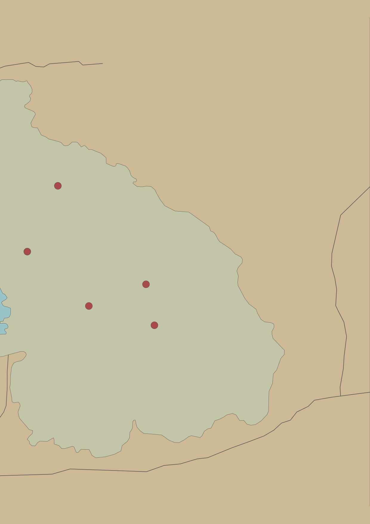
Location of Tipeshwar(2011) prior to relocation

Population- 538 Total Area- 756 ac. Hamlet Area- 11.2 ac.
No. of houses- 218 Village density- 19.4 house/ac. 48.1 people/ac.
Distance to city- 25 km paved- 16 km unpaved- 14 km

natural resources

opportunities
living standards social interaction accessibility amenities


Tipeshwar, which is beside a body of water, has a street that divides the main village from the ghats.
The ghats are a sacred and public area, making them a popular location to store extra goods or gauris (dried cow dung cakes)
Fig 12 Tipeshwar 2011 macro level study:Author
The northern edge of the lake exclusively used for washing purposes

Temple at southern edge of lake. Water from this edge is also used for daily needs.


The northern edge of the lake designated for washing
common storage
Major nodes indicate the points of inception of villages
The square developed as a meeting point for all the farm going people where they would share the problems they are facing and also might fnd a solution to the issue.
Since Tipeshwar is located close to a body of water, many daily activities centre around it.
The lake water is used for rituals as well as regular tasks including washing clothes, cleaning cattle, and drinking water. There is a large area of land between the water source for drinking and the area for washing and cleaning.
The main occupation of the settlement as farming with cotton as the main produce. as cotton crop fequries a lot of water, every farm had its own well, which met their need for water. Youths were engaged as tourist safari guides with forest department

In addition to the small sum that the Patils (village head) received from the Gram Panchayat (Maregaon). The community produced revenue by collecting 2000 rupees per banda (shed) per season for a common storage place by the lake. The money was utilised to organise the festivals and other events of shared interest.
Tipeshwar had two castes- the Gonds and the Kollams but there was no segregation based on caste.
Considering how closely interwoven the rural communities are. The begin ning of the colony is typically where the people meet. The elderly love to sit there since it is where their memories are concentrat ed. And later, when they bring their grandchildren along, even they grow to love the location. It is not required to be a shop.
The hierarchy of spaces within a dwilling was quite simple with a semipublic area, with a bed and chairs. this further led to a private bed room and then a kitchen, which opened in a backyard. Cattles are usually kept beneath a shed at tatched to the house.
Tipeshwar was a prosperous village and usually after few years children usually move out to start their own household. but is certain cases the existing house is literary divided in two households by erecting a wall in the centre.

Location of Tipeshwar(2022) post relocation

Population- 156
Total Area- 9.42 ac. Hamlet Area- 9.42 ac.
No. of houses- 72 Village density- 7.6 house/ac. 16.56 people/ac.
Distance to city- 27 km paved- 27 km unpaved- 0 km

natural resources
opportunities
living standards social interaction accessibility amenities

A lot of vacant plots can be seen in Tipeshwar(2022) as a lot of people chose to leave the village after 5-6 years of relocation and as a result the village is a mixture of cement houses, mud houses and vacant plots in between
Fig 15 Tipeshwar 2022 macro level study:Author

TIPESHWAR (2022)
The of tipeshwar were initially offered a one time 10lakhs per family in compensation under the golden handshake scheme, but the kollam caste which constituted 40% of the population opted for option two, which is relocation of the village and were compensated rupees 5lakhs and eventually were alloted the current location which was also 27km from Pandharkawda, but was conneted by a tarred road.

landowners from nearby villages take daily waged labours from the square. locally daily wage labourers are also known as ‘panchhi’

Fig 16 Tipeshwar 2022 daily life and dwelling study: Author
A Reservoir was created by building bund wall at boundries of lowlying area. the watr is used for household activites but washing is not allowed in the reservoir
Temple along waterbody
Tipeshwar has a mixture of cement houses and mud houses

Foot trail also known as ‘paivat’ asre created as people take shortcuts through vacant plots Middle school from 1st till 5th standard
with no land in hand and being 27 km from taluka, Tipeshwar(2022) eventually became dependent on neighbouring villages from work as daily labours.
Major occupation here is daily wage labours which over 60% of population(both men and woman).
Dairy and cattle also has some contribution in their income but its negligible as neighboring villages are self suffcient in terms of dairy and cattle products.
As a result of no land, no job opportunities and low compensation package the youth eventually started to leave the the village in search of better life.
With only 72 houses scattered over an area of 9.42ac. as the plots were alloted acording to a luckey draw , makes village sparced and hence very less interaction between the residents
When people arrived at the new location, the started building their houses with traditional methods and eventually started building houses with cement once they got upto 2.35 lakhs in funds from Pradhan Mantri Awas Yojna (PMAY)

Plan of house built under PMAY scheme


Section of house built using traditional techniques
Fig 17 Tipeshwar 2022 daily life and dwelling study: Author
Location of Maregaon(2013) prior to relocation

Population- 592 Total Area- 985 ac. Hamlet Area- 10.53 ac.
No. of houses- 263
Village density- 24.9 house/ac. 46.72 people/ac.
Distance to city- 32 km paved- 14 km unpaved- 18 km

natural resources

opportunities
living standards social interaction accessibility amenities
Given that Maregaon is an older village, each cluster of houses in each plot of land originally belonged to one family. However, as time went on, the number of houses in each plot of land increased and formed a cluster, and intriguing interactive spaces where different families interacted started to form between the clusters.


Fig 18 maregaon 2011 macro level study:Author

Each larger plot of land further forms a cluster.
Open area for weekly market.
Street View of Maregaon 2013


19 maregaon 2011 layout study: Author
Places of interaction between two clusters
Maregaon(2013) was the most active town in the vicinity with the only town to have a post offce and a gram panchyat. there are many small villages which come under the Maregaon gram panchyat like Tipeshwar and Pitapongari. Each village have their representative in the panchyat which is the main governing body in the vicinity. Apart from farming, which is the major occupation in the village, the village is also major market town in the area. Maregaon caters to various occupations like woodworking, blacksmiths, cobbler,
potter etc. Hence Maregaon is place where people from nearby villages visit every friday for weekly market where people could buy thing brought from the cities. Youths were engaged as tourist safari guides with forest department

Typical residence of a small scale business man in Maregaon(2013)

‘Dailaji” is a semi private spcae at the enterence of the house for business meetings or storage. This the place strangers enter into and not directly in the main house

‘Konada’ or a niche is a small storage spcae for things like walets, keys, notebooks etc.
‘Kavelu’ or country tiles is one of the roofng material still used extensively in rural india. These tiles are usually fred and the way they are laid in an interlocking fasion prevents the rainwater from entering. Layer of thatch is laid under them which acts as an insulator.
Fig 20 maregaon 2011 daily life and dwelling study: Author

Location of Maregaon(2022) post relocation
Population- 420 Total Area- 24.4 ac. Hamlet Area- 24.4 ac. No. of houses- 182 Village density- 7.52 house/ac. 17.2 people/ac.
Distance to city- 2 km paved- 2 km unpaved- 0 km

natural resources
opportunities
living standards social interaction accessibility amenities
Maregaon(2022) is planned in a grid pattern but as village expanded and more families moved in the village starts growing in organic pattern and inception of new clusters can be observed.

Fig 21 maregaon 2022 macro level study:Author

Maregaon was relocated in the year 2013. The villagers chose to go with option two ,that is they forfeit their agriculture land and recive 15 lakh rupees compensation plus one 1000sqft. residential plot per family.
The village has seen expansion on the southern side with new residences comming up. Due to proximity to the town, procuring of material for construction has been much easier.

Middle school.
Orignal intended entrance.
Part of villge segregated due to level difference. This part of the village has observed more migration as compared to the other half.

The who live the are called ‘tekdiwale’ literally translating to “hill people”
Foot trails shows the actual entrance used by the people Even though the village is near the town and has been near a decade after the relocation, the civic infrastructure is nt that well developed.
Waterlogged entrance to the village

Maregaon had a better compensation package and village location as compared to tipeshwar village
The village is located within 2kms of Pandharkawdda taluka. Since the people do not own any land unless they bought it , the major part of their income comes from livestock by selling dairy products to pandharkawda.
Being near to Pandharkawda means that the youth of the village have better access to education and other job opportunities. People from the village still work as daily wage labours but majority of them prefer to work as helpers and waiters in shaops and restauraunts in pandharkawda.
Some of the people have bought a small peice of land in the vicinity of the village and practice horticulture and sell the seasonal products in the town.


Using door frame as lintel to reduce cost of construction Maregaon(2022) had open drains and when recently the central road was concretised, the road level went above the level of front yard of the residents.


So when it rains heavily, the drain water over fows into the frontyard

Location of Ranbodi(2018) prior to relocation

Population- 423 Total Area- 624 ac. Hamlet Area- 6.03 ac.
No. of houses- 133 Village density- 22.1 house/ac. 70.2 people/ac.
Distance to city- 15 km paved- 9 km unpaved- 5 km

natural resources
opportunities
living standards social interaction accessibility amenities
Ranbodi(2018) was a town sililar to Maregaon(2013) in layout. various clusters could be observed where the residents asre related. The village mostly consists of gond caste but there is a separate cluster of bhramin caste which is a bit detatched from the main village.
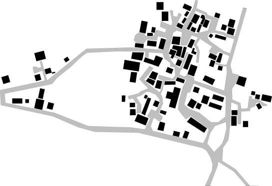

Fig 24 ranbodi 2018 macro level study:Author

Temple and the bhramhin community around it
spaces in between cluster forms interactive spaces
The square where farmers and workers meet before going to their own feilds

The front yard is a space used by women while doing their daily chores

Cluster oh houses which have eventually formed as families got divided in indivisual household
Ranbodi, though samll in size was a very prosperous village. apart from agriculture, ranbodi was highly engaged in cattle rearing.
They produced and supplied dairy to nearby villages and also rented agriculture equipments and bulls for farming.
Youths were engaged as tourist safari guides with forest department Ranbodi also sold a lot of forest produce like fuits and berries by setting bu stalls on roadside which was about 9km from the village.
They also collected and sold ‘Tendu’ leaves duing the season to businessmen which was used to make ‘bidis’.
The factors affecting Ranbodi’s prosperity was a high water table, which is advantageous when harvesting cotton. But being situated in the interiors of the forestsed area and no public transport, the travel time for a mere 15km was three hours and was disconnected from the town during the monsoons.

The dwellings in Ranbodi had a lots of storage space for the crops
outter wall of the storage unit modifes as a plce to sit and chat
entrance to a cluster where each house is a different household in itself within a family
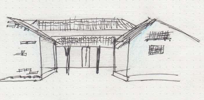

Fig 26 ranbodi 2018 daily life and dwelling study: Author

Population- 362 Total Area- 17.2 ac. Hamlet Area- 17.2 ac. No. of houses- 133 Village density- 7.73house/ac. 21 people/ac.
Distance to city- 2 km paved- 2 km unpaved- 0 km


natural resources
opportunities
living standards social interaction accessibility amenities
Ranbodi(2022) is a recently settled village and is planned in a grid pattern, with a open ground on the eastern side which is a common place for all social activities.


The plots of land were alloted in such a way that adults mem bers from the same family were able to pool their land to build a bigger house.
Fig 27 ranbodi 2022 macro level study:Author

The village Ranbodi(2022) was relocated in the year 2018 from the interior of Umred Karandhala Wildlife Sanctuary (UKWLS). Ranbodi has a very strategic location as it just a couple of km away from Umred, a fast growing town in Nagpur District and the vllage is expected to be absorbed by the same soon.

‘Tapri’ a daily needs shop
Space left for future constructions

The grid planning of village Ranbodi (2022) lacks interactive pockets where people could meetup
Fig 28 ranbodi 2022 layout study: Author
Ranbodi(2018) had clusters of dwell ings which belonged to a same family and there were plenty of places where two clusters could interact. Which indicates that Ranbodi(2018) was a close knit com munity, but these clusters and interac tion spaces were lost when Ranbodi(2022) was setup according to a grid pattern.
Unlike Tipeshwar(2022), the land allotment was done according to the layout of Ranbo di{2018) where each person would prefera bly get the older neighbour besied him or in a close vicinity. the villagers were involved in the process of land allocation. This had a hand in stopping people from leaviing the village and settleing somewhere else.
Some people have started businesses to cater to the highway going by opening tyre repair shops for trucks as well as ‘dha bas’ to serve the traveling passengers.

Even though the village has low social activ ity in the immidiate context of the residenc es, the ‘baithak’ beneath the huge mango tree is a place where kids prefer to play in the afternoon, as the day cools down, the elder ly people come for their evening stroll and eventually end up chating for an hour or two

The people of Ranbodi reived the compensation or relocation and funds from Pradhan Mantri AAvas Yojna (PMAY) close to each other and hence were able to comple the construction of their houses in time.

Being near to Umred, has opened a lot of opportunities for the residents.People now work in umred as helpers in shops & petrol pumps or waiters in restaurant. it has also opened up a lot of opportunities for the youth who want to seek higher education.


Pitapongari is a village situated in the Tipeshwar Wildlife Sanctuary and is proposed to be relocated by the forest department. The idea is to create a matrix addressing all the factors that infuences life in Pitapongari

Location of Pitapongari


Population- 182 Total Area- 130.2 ac. Hamlet Area- 3.4 ac. No. of houses- 45 Village density- 13.2 house/ac. 53.5 people/ac.
Distance to city- 21 km paved- 9 km unpaved- 12 km
Built Form Unbuilt Form Housing Layout


natural resources

opportunities
living standards social interaction accessibility amenities
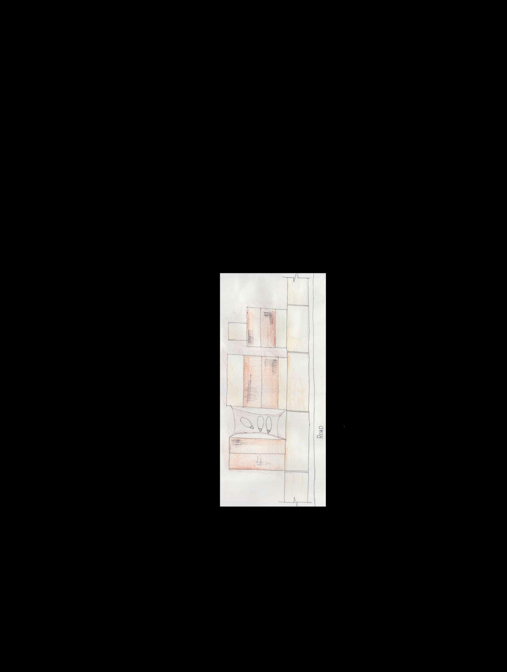
Pitapongari is a small village where two unique housing confgurations were observable. On the western side, the frst being the clusters of houses with intersecting streets. The second is a row of dwellings with streets extending on both sides of each home. which, using the homes’ yards as bridges, creates some intriguing paths between the two streets.
Clusters formed over generation
Spaces between clusters which acts as interaction spaces


Scene around the handpump


The row of houses have a common front yard which is used by ladies to do chores, kids to play and people

In the evening time, this place is the most actve as everyone comes out fron the house to have an evening
Storage Front Street Front yard House Rear Street
Street section across houses and storage.

A typical plan of house in Pitapongari village
House 2
2 Houses from a cluster sharing the same ‘gotha’(place to keep livestock) & storage space.


Gotha
Common storage
House 1
Fig 33 pitapongari daily life and dwelling study: Autho


How can one consider if a village relocation has been sucessfull or not?
In easy words we can say that a relocation is sucessful if the residents of the village do not feel a need to leave the place in order to fulfll basic life needs
Formation of village is a long process and takes place over a long period of time. The streets and the whole village layout of villages like Ranbodi(2018) or Maregaon(2013) are formed around the clusters. The adjecent clusters grew and eventualy the space in between them became streets. Apart from serving the purpose of streets the places have been a point of interaction between two clusters and even though is a public place, thers a sense of ownership, sense of pride for that space.
Clusters expanding and eventually forming a street at interface.

In the village Ranbodi, the residents of veiialge were involved in the process of allocation of land for home and the collectively came up with a allotment scheme of plot which retained their old neighbours and land of people who were planning to shift to umred (vacant plots) were also taken in account while planning.And hence four years of relocation Ranbodi(2022) have retained most of their population.
Unlike in the case of Tipeshwar village, the allocation of land for residences was done according to a lucky draw and hence all the neighbors and relatives which they have a bond with had been shuffed.
If a family were to shift to a new location it tries to ft in with the community and bond with new neighbours as you have no contacts
there but in this case there was no existing community at frst place to join in and theres a sense of longing when they see their old bestfriend who used to live besides them is now situated across the town. A good analogy would be a teacher shuffeing a class to reduce the chattering(interaction) between children. Which should not be the case in this situation. And combined with other factors like employment issues, no land in hand, and being far from town. People eventually start migrating as there is no connect, or sense of ownership towards the new town as theres no involvement of the actual stakeholders in the whole process of setting up a village.
Since no two people can have the exact same home, every house must be unique. Standardization doesn’t always imply that the standardised object (in this case, a dwelling) must be identical. Standardization is more accurately described as a set of restrictions or components that can be combined and permuted to create the ideal home for each individual.

One of the most crucial questions to be answered is village layout and planning because a village’s layout greatly infuences its character. The layout planning determines how the density varies from node to node and how it reveals different spaces that, once again, may be hidden or be visible to everyone.

The following diagram shows the distribution of programs that are possible on site wrt taking housing and layout planning as the main focal point around which rest of the programs are built keeping the idea of keeping the character of village intact is considered upon.

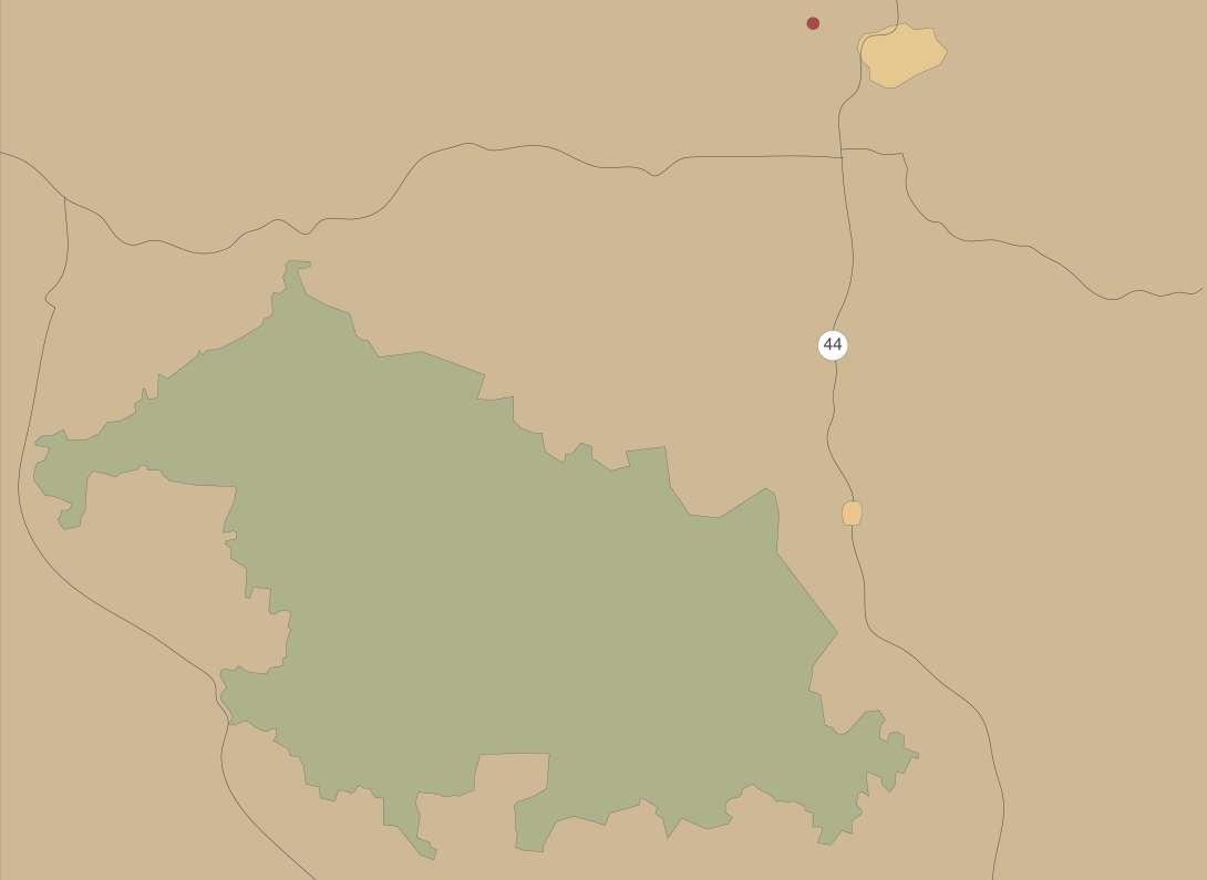
Currently the relocation of Pitapongari in under negotiation and according to the forest department the following is a possible provisonal site for reloction of new village.


In comparison to the current location, which is 21 kilometres away from Pandharkawda, the proposed site is only 2 kilometres away. As a result, connectivity would signifcantly improve.
Pitapongari currently covers 130.2 acres, including farms. The village’s residents may receive compensation equal to up to 80% of their land because the proposed site is 104 acres in size.

It’s important to keep in mind, however, that because the proposed site is so close to Pandharkawda, the value of the land will increase over time.
The proposed location is diagonally across from Maregaon(2022), which, like Maregaon(2022), will receive a lot of new job and educational opportunities.
Maregaon(2022)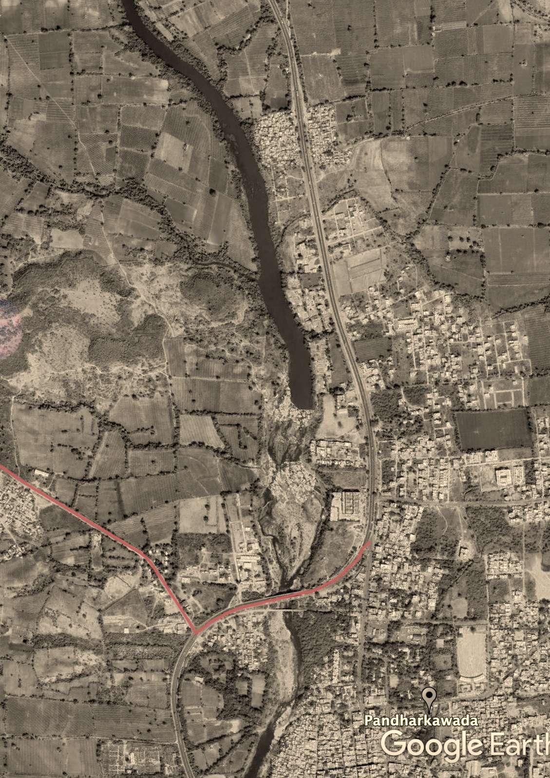


 Fig 40 Images of site: Author


-https://www.jstor.org/ stable/4417387?seq=2#metadata_info_tab_ contents
-https://www.wrm.org.uy/sites/default/ fles/2022-03/Struggles-to-live-in-forestsProtected-Areas-India.pdf
-http://forestsclearance.nic.in/ writereaddata/0_0_15_Jul_2017_154131937_ recomm_PartIV.pdf
-https://www.india.gov.in/topics/environmentforest/wildlife
-https://www.epw.in/journal/2020/30/ perspectives/relocation-tigerreserves-under-ntca-guidelines. html?destination=node/157204#
-https://www.epw.in/journal/2009/49/specialarticles/displacement-and-relocationprotected-areas-synthesis-and-analysis
-https://www.epw.in/journal/2005/46/ commentary/tadoba-andhari-tiger-reserverelocation-versus-wildlife-preservation.html
-https://www.epw.in/journal/2018/15/notes/ forest-rights-act-2006.html
-https://www.epw.in/journal/2013/31/ commentary/implementation-forest-rightsact.html
-https://villageinfo.in/maharashtra/yavatmal/ kelapur/pitapongari.html
-https://villageinfo.in/maharashtra/nagpur/kuhi/ ranbodi.html
- https://legislative.gov.in/sites/default/fles/ A1972-53_0.pdf
-https://tribal.nic.in/downloads/FRA/ FRAActnRulesBook.pdf
-Rural Design Studio ‘18 by ideas
-Rural Design Studio ‘19 by ideas
-Rural Sociology in India by A.R. Desai -India’s Changeing Villages S. C. Dube
-National Parks of India by R.S. Bisht
Fig 1 image of a tiger: Sharosh Lodhi
Fig 2 entrance to pitapongari: Author
Fig 3 patil of tipeshwar(2022) telling stories: author
Fig 4 image of tiger from TATR: Author
Fig 5 fowchat of process of relocation: Author
Fig 6 illustration of village meeting: Author
Fig 7 vacated area of Botezari village: Author
Fig 8 map of TATR: Author
Fig 9 image of discussion in patapongari: Author
Fig 10 web of factors affecting a village sociology: Author
Fig 11 Image of frontyard in pitapongari:Author
Fig 12 Tipeshwar 2011 macro level study:Author
Fig 13 Tipeshwar 2011 layout study: Author
Fig 14 Tipeshwar 2011 daily life and dwelling study: Author
Fig 15 Tipeshwar 2022 macro level study:Author
Fig 16 Tipeshwar 2022 layout study: Author
Fig 17 Tipeshwar 2022 daily life and dwelling study: Author
Fig 18 maregaon 2011 macro level study:Author
Fig 19 maregaon 2011 layout study: Author
Fig 20 maregaon 2011 daily life and dwelling study: Author
Fig 21 maregaon 2022 macro level study:Author
Fig 22 maregaon 2022 layout study: Author
Fig 23 maregaon 2022 daily life and dwelling study: Author
Fig 24 ranbodi 2018 macro level study:Author
Fig 25 ranbodi 2018 layout study: Author
Fig 26 ranbodi 2018 daily life and dwelling study: Author
Fig 27 ranbodi 2022 macro level study:Author
Fig 28 ranbodi 2022 layout study: Author
Fig 29 ranbodi 2022 daily life and dwelling study: Author
Fig 30 image of frontyard pitapongari: Author
Fig 31 pitapongari macro level study:Author
Fig 32 pitapongari layout study: Author
Fig 33 pitapongari daily life and dwelling study: Author
Fig 34 image of people discussing pitapongari map: Author
Fig 35 illustration showing clusters:Author
Fig 36 Illustration showing programs: Author
Fig 37 sketck showing importance of layout: Author
Fig 38 image of site: Author
Fig 39 map of site: Author
Fig 40 Images of site: Author