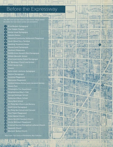
Before the Expressway This 1962 land use map shows us what Queen Village looked like before the Front Street corridor was demolished. 1
B'nai Reuben Synagogue
2
The Yiddish Theatre
3
Kesher Israel Synagogue
4
Abbotts Dairies
5
Historical Community Settlement Playground
6
South Street Ferry Terminal
7
Spalding Tenament House
8
Ahavas Israel Synagogue
9
Southern Dispensary
1
10 Kahillis Israel-Nusach Sfard Synagogue 11
William Meredith School
12 B'nai Israel-Anshe Poland Synagogue 13 St. Stanislaus Church and School 14 Polish Social Club 15 Church 16 Kahal Adath Jeshurun Synagogue 17
Neziner Synagogue
18 Sunshine Playground 19 Weccacoe Playground 20 Central Hebrew School and Literature Society
18
21 Queen Park 22 Philadelphia Fire Department 23 Neighborhood Boy's Club 24 George Nebinger School 25 Settlement Music School 26 Henry Burk School 27 St. Philip Neri Church and Rectory 28 Adath Israel Synagogue 29 St. Philip Neri School and Convent 30 Shot Tower Playground 31 Polish Bethel Church 32 Gloria Dei (Old Swedes') Church 33 Hector McIntosh Playground 34 Emanuel German Evangelical Lutheran Church 35 Nazareth Church 36 Mariners' Bethel Church Map Credit: Free Library of Philadelphia, Map Collection
24

