TODAY
26o
Mostly sunny
23o 23o 23o THURS
FRI
SAT
Alex is happy to be home
www.wangarattachronicle.com.au
Wednesday, October 19, 2022
plus
tv
GUIDE
Page 5
$1.50 INC. GST
Phone (03) 5723 0100
WDCA fixture change
Sport
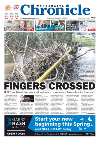
THOU SHALL NOT PASS: Debris has blocked the footbridge between Walter Street and Willow Drive, after the creek rose above the handrails at the weekend. PHOTO: Kurt Hickling
FINGERS CROSSED SES confident river rises will not reach more severe levels despite p forecast
DOWNPOURS forecast from as early as tomorrow are not expected to create major flood activity in the North East, with SES officials expecting the region’s worst flooding is behind us. Between 30 and 55mm is expected to fall on Wangaratta from tomorrow through to Saturday, as the region’s major rivers continue to drain after reaching the major flood
BY RYAN MALCOLM rmalcolm@ nemedia.com.au
level late last week. After peaking at 12.78m on Saturday morning, the Ovens River sat just above the moderate flood level yesterday, at 12.41m. In total, between 55 and 110mm is forecast through to Monday by the Bureau of
Meteorology. SES incident controller Ray Jasper said accurate rainfall modelling was expected to become available today, but said early indications suggested river rises would not be as severe as the week previous. “The (early) modelling unfortunately is showing that the North East is going to get the highest rainfall come Thursday, Friday and Saturday - you will see river
rises in the North East at the Ovens, Kiewa, King and other tributaries,” he said. “At this stage we’re still trying to work out what the impact is - we need to reinforce for people it won’t be as bad as last week’s (rainfall). “The catalyst on it is that there may be thunderstorms bedded in it - if a thunderstorm forms over one of the sub-catchments or is large
enough, we may see things happening in some of the sub-catchments. “In saying that, we can’t encourage everyone enough to be vigilant - those who don’t have the Vic Emergency app please register - that’s our primary source of getting information out about what’s happening in your area.” Modelling for last week’s flooding event saw SES
confident of the region’s expected rainfall days ahead of the downpour, with local units establishing sandbag collection points to assist residents in their preparation. Mr Jasper said surplus sandbags had been forwarded onto Shepparton in the aftermath, where 225,000 sandbags have been laid to protect the local community. ■ Continued page 2
Start your new beginning this Spring and SELL SMART today!