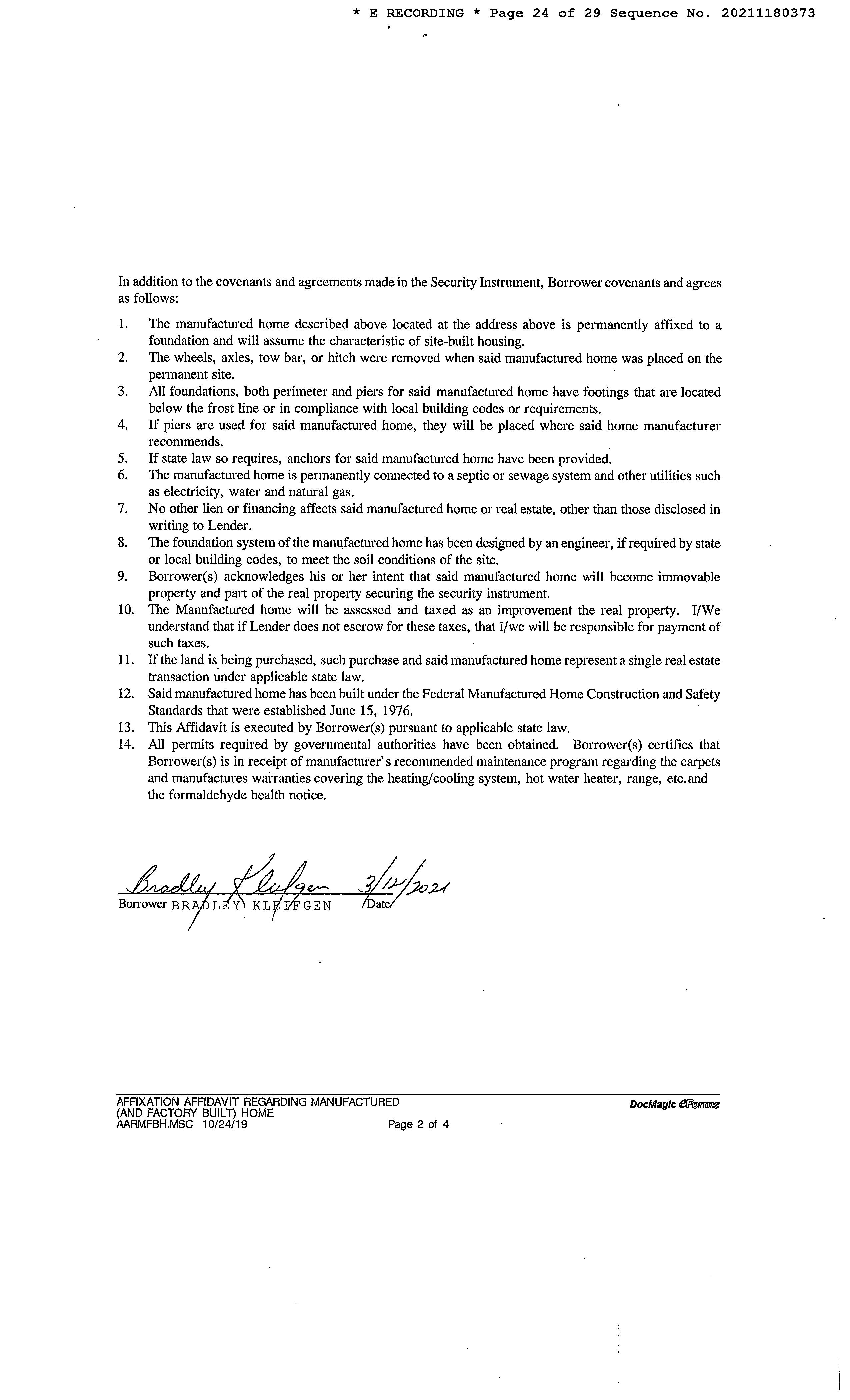
LIMITATION OF LIABILITY FOR INFORMATIONAL REPORTS
IMPORTANT -- PLEASE READ CAREFULLY:
This report is not an insured product or service or a representation of the condition of title to real property. It is not an abst ract, legal opinion, opinion of title, title insurance commitment or preliminary report, or any form of Title Insurance or Guaranty. This report is issued exclusively for the benefit of the Applicant therefor and may not be used or relied upon by any other person. This report may not be reproduced in any manner without First American or Title Security's prior written consent. First American or Title Security does not represent or warrant that the information herein is complete or free from error, and the information herein is provided without any warranties of any kind, as-is, and with all faults. As a material part of the consideration given in exchange for the issuance of this report, recipient agrees that First American or Title Security's sole liability for any loss or damage caused by an error or omission due to inaccurate information or negligence in preparing this report shall be limited to the fee charged for the report. Recipient accepts this report with this limitation and agrees that First American or Title Security would not have issued this report but for the limitation of liability described above. First American or Title Security makes no representation or warranty as to the legality or propriety of recipient's use of the information herein.

Disclaimer
This REiSource report is provided "as is" without warranty of any kind, either express or implied, including without limitations any warrantees of merchantability or fitness for a particular purpose. There is no representation of warranty that this information is complete or free from error, and the provider does not assume, and expressly disclaims, any liability to any person or entity for loss or damage caused by errors or omissions in this REiSource report without a title insurance policy.
The information contained in the REiSource report is delivered from your Title Company, who reminds you that you have the right as a consumer to compare fees and serviced levels for Title, Escrow, and all other services associated with property ownership, and to select providers accordingly. Your home is the largest investment you will make in your lifetime and you should demand the very best.

Data Provided By: First American Title Ins Co
© 2023 CoreLogic. All rights reserved
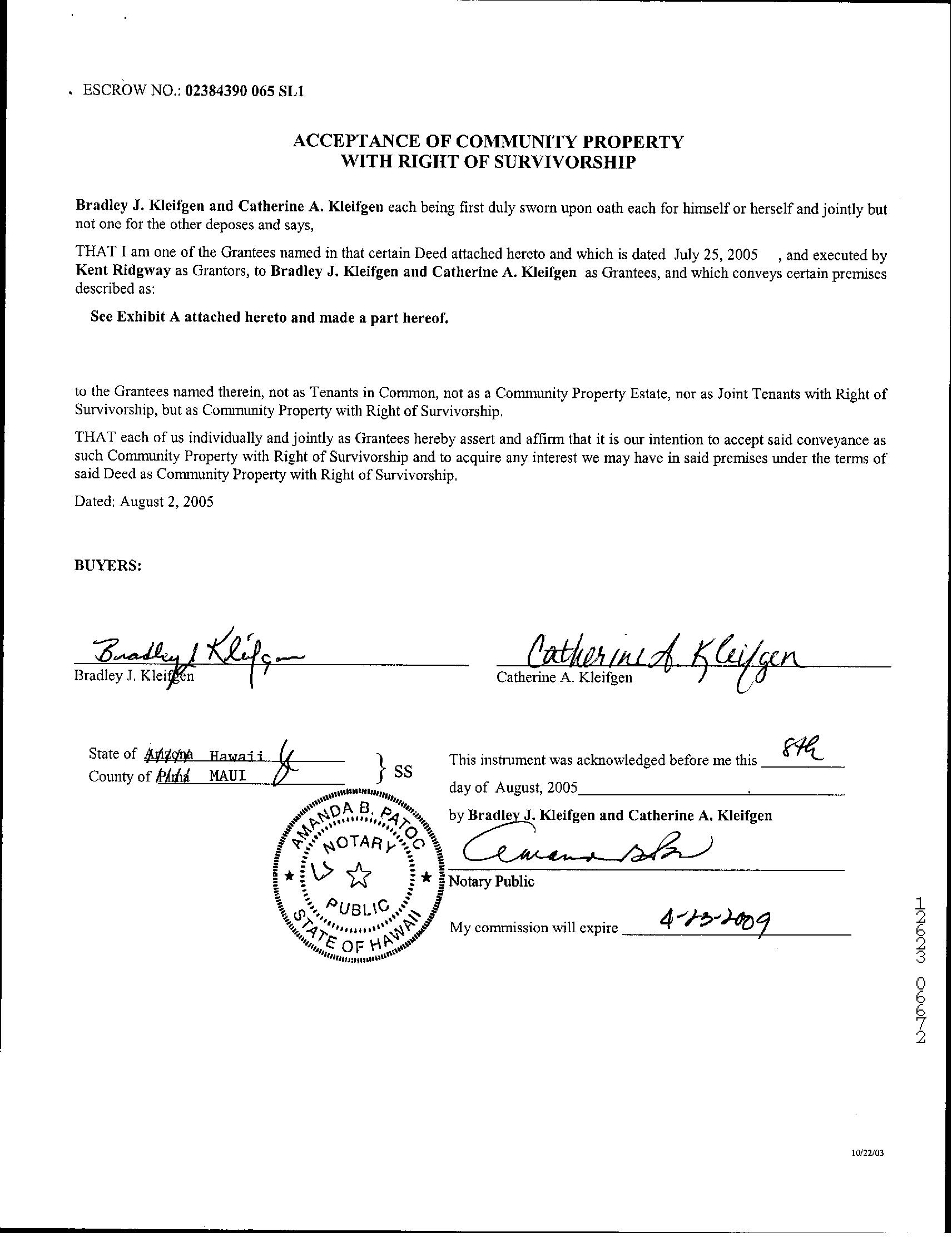
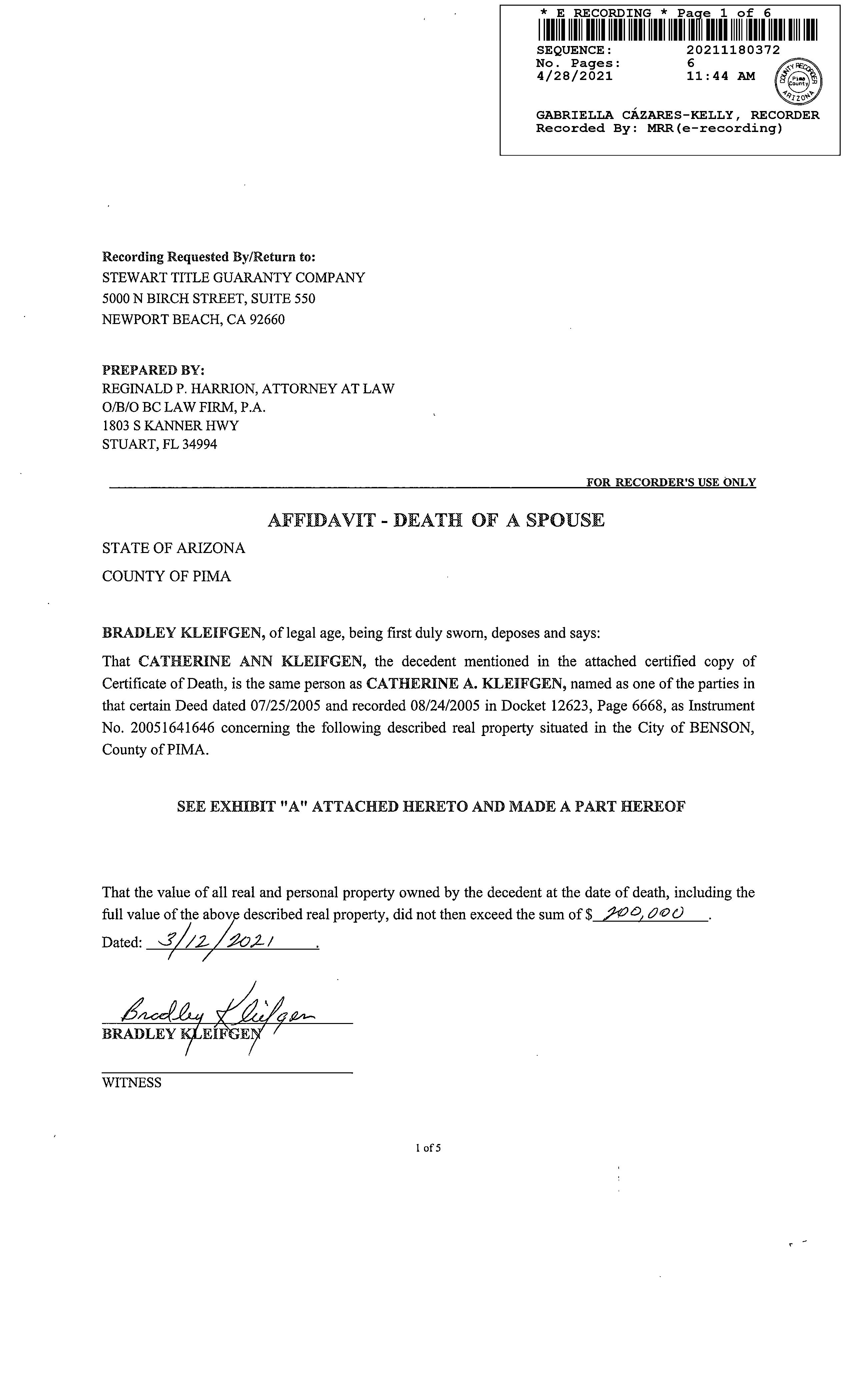
Subject Property : 14187 S Dusty Springs Pl Benson AZ 85602
Owner Information
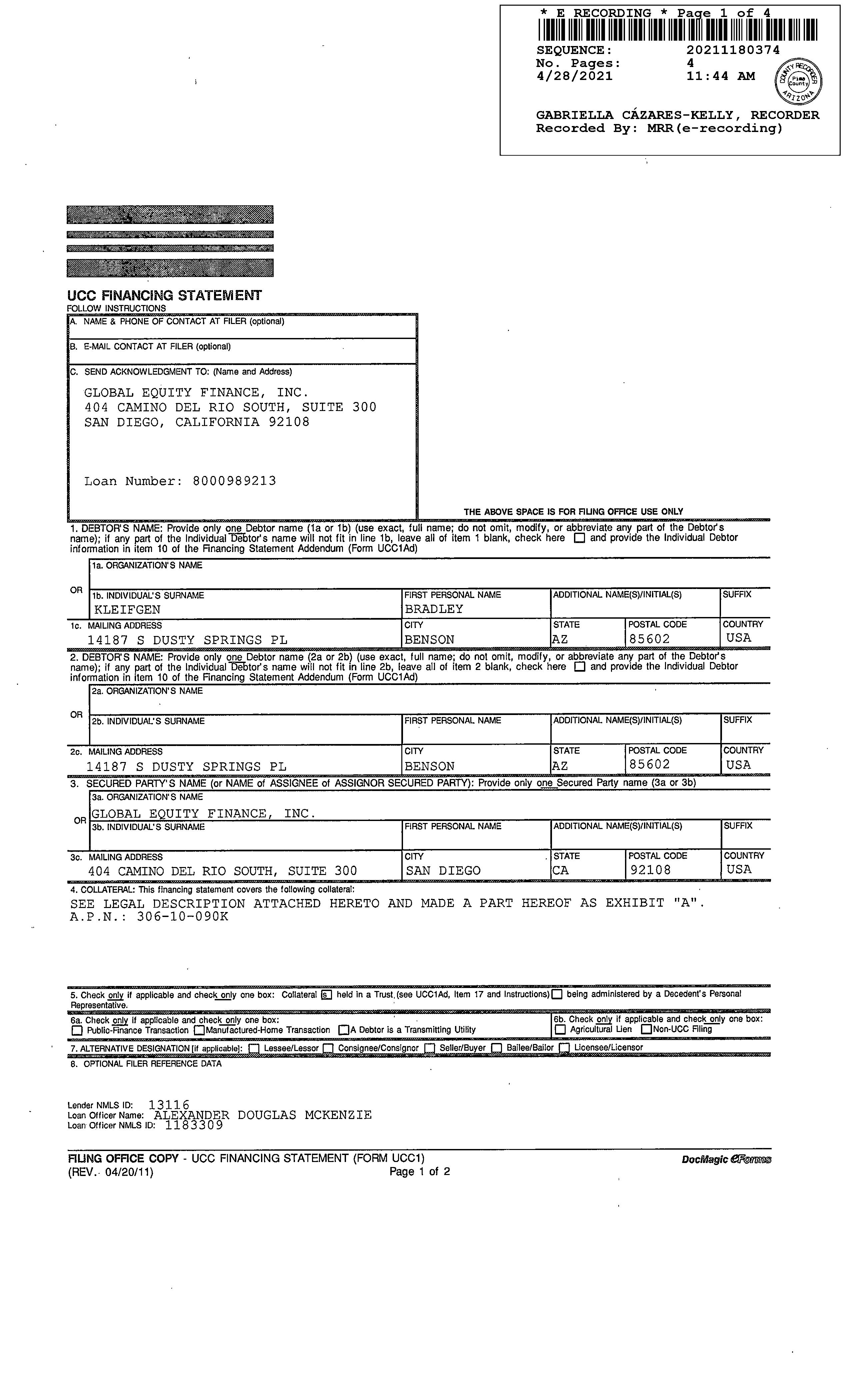
Owner Name : Kleifgen Bradley
Mailing Address : 14187 S Dusty Springs Pl, Benson AZ 85602-5621 H002
Vesting Codes : / / Community Property
Owner Occupied Indicator : O
Location Information
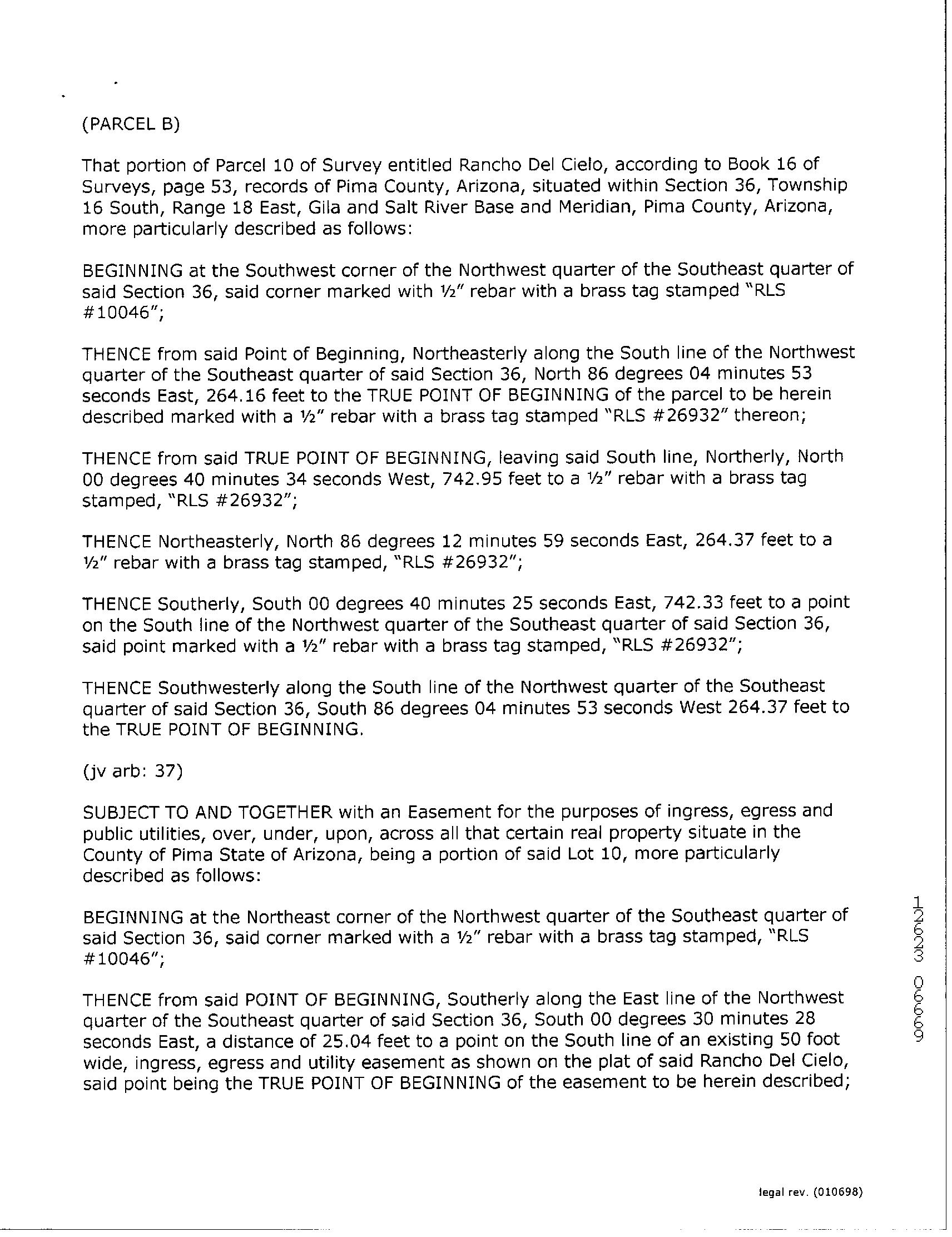
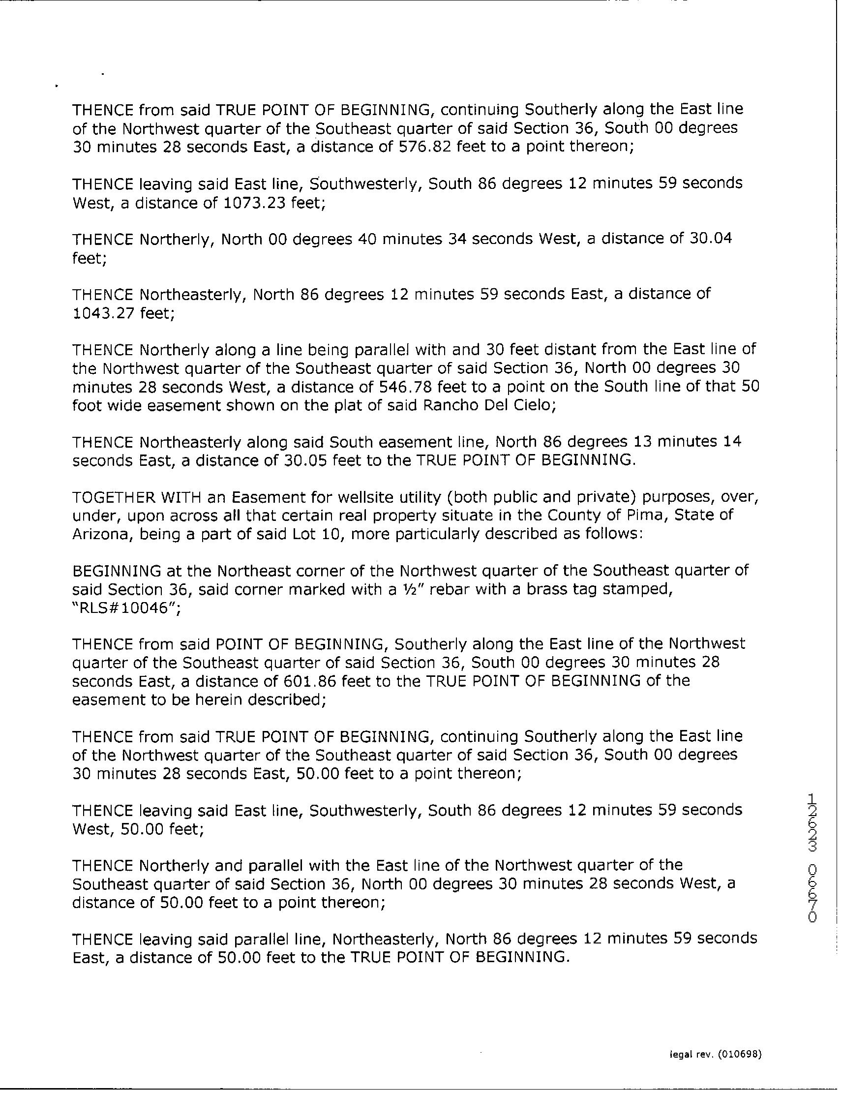
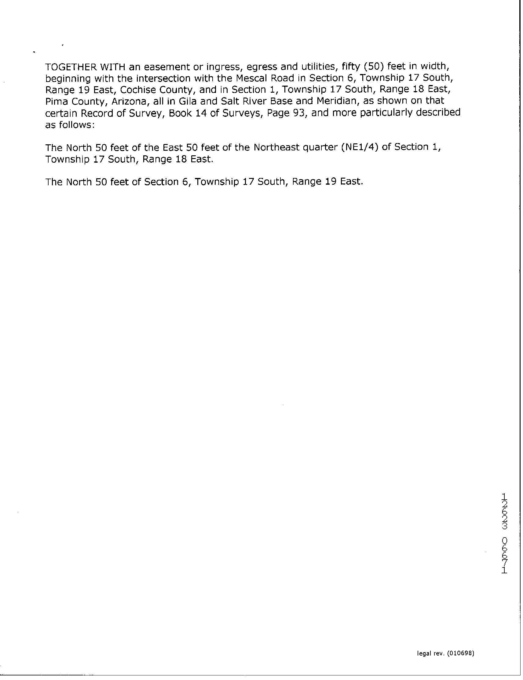
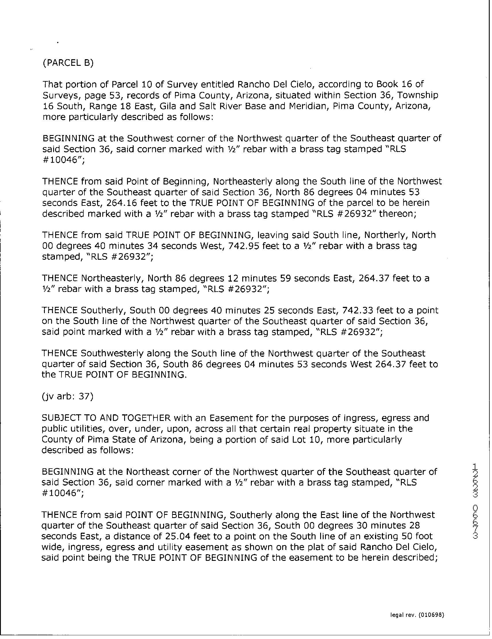
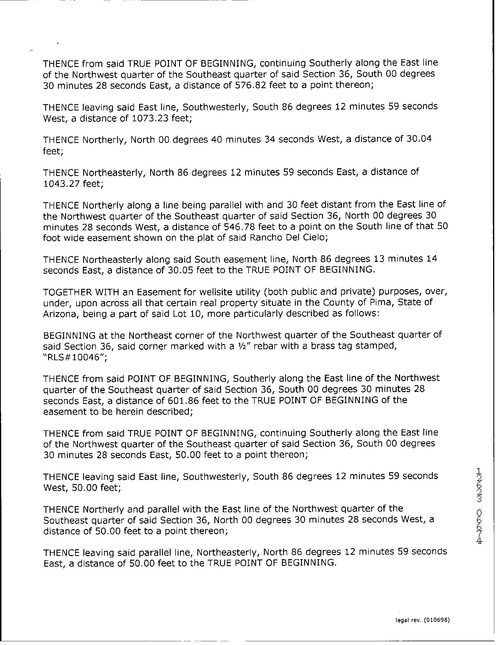
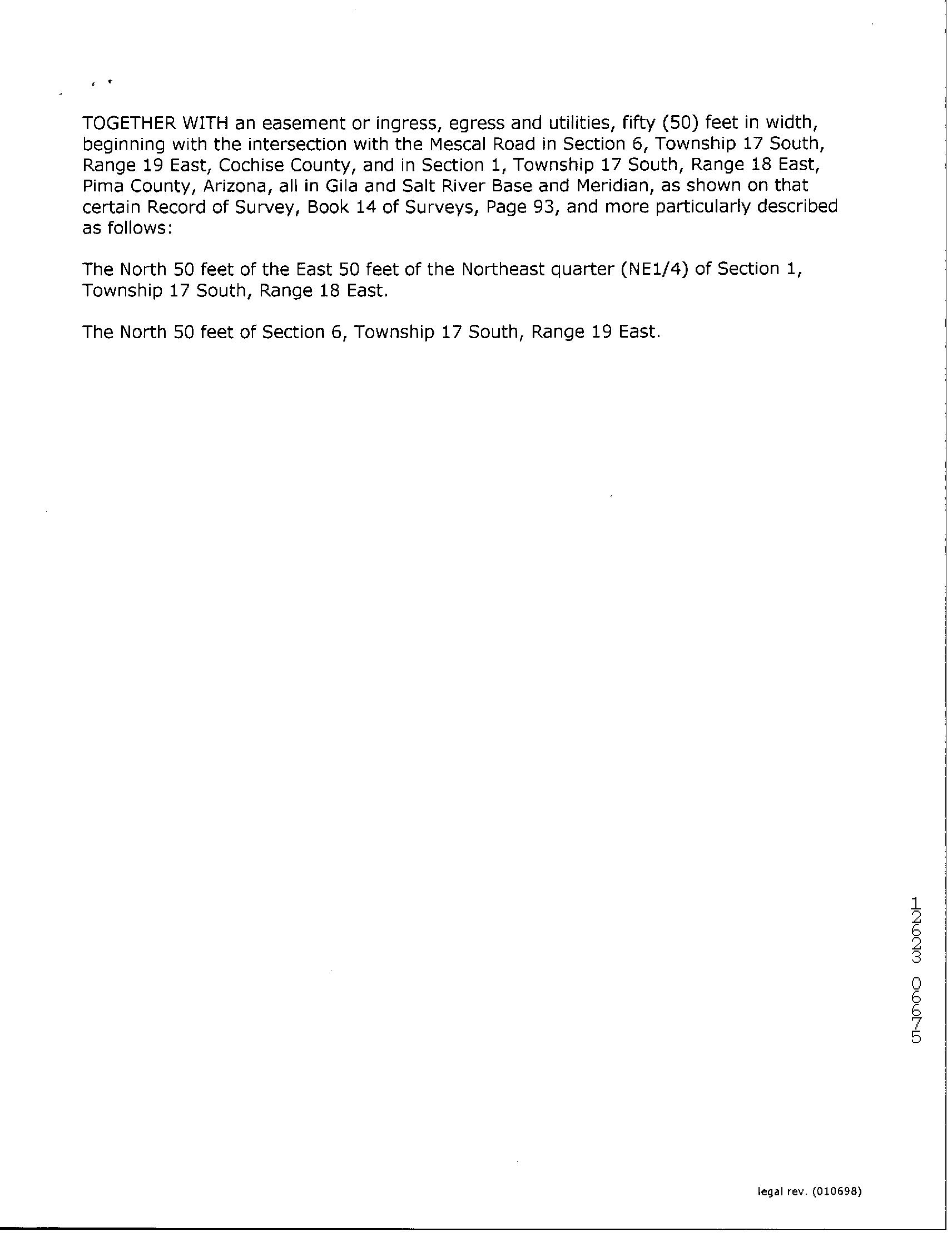
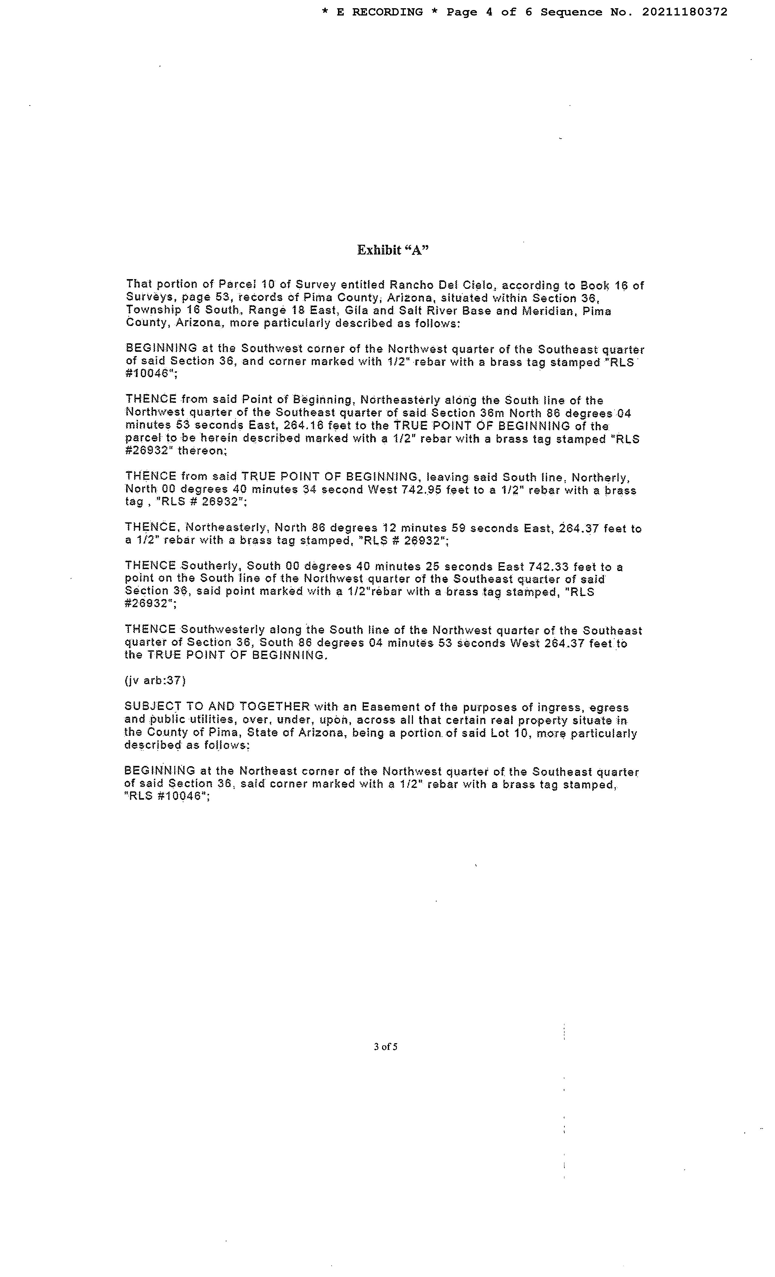
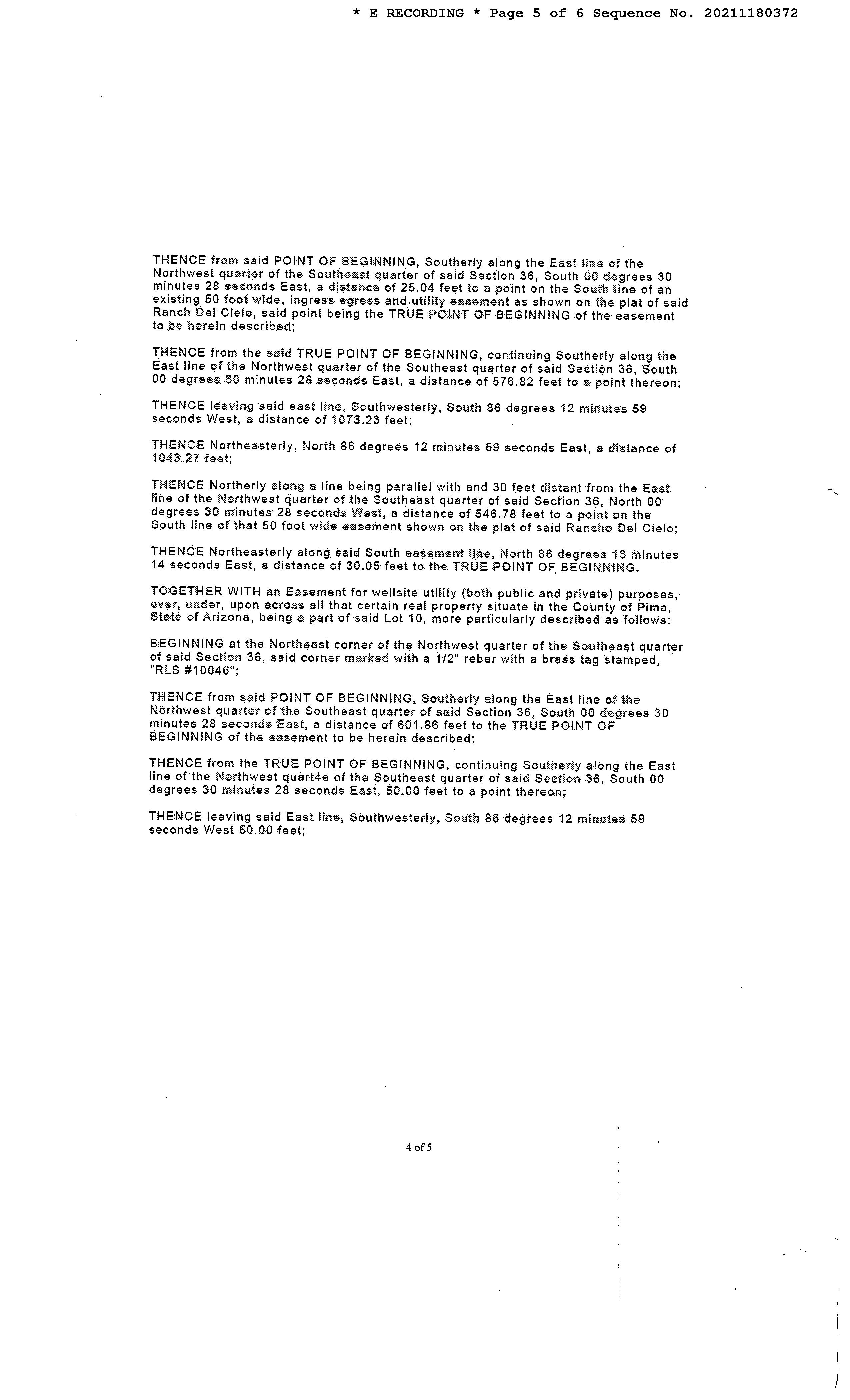
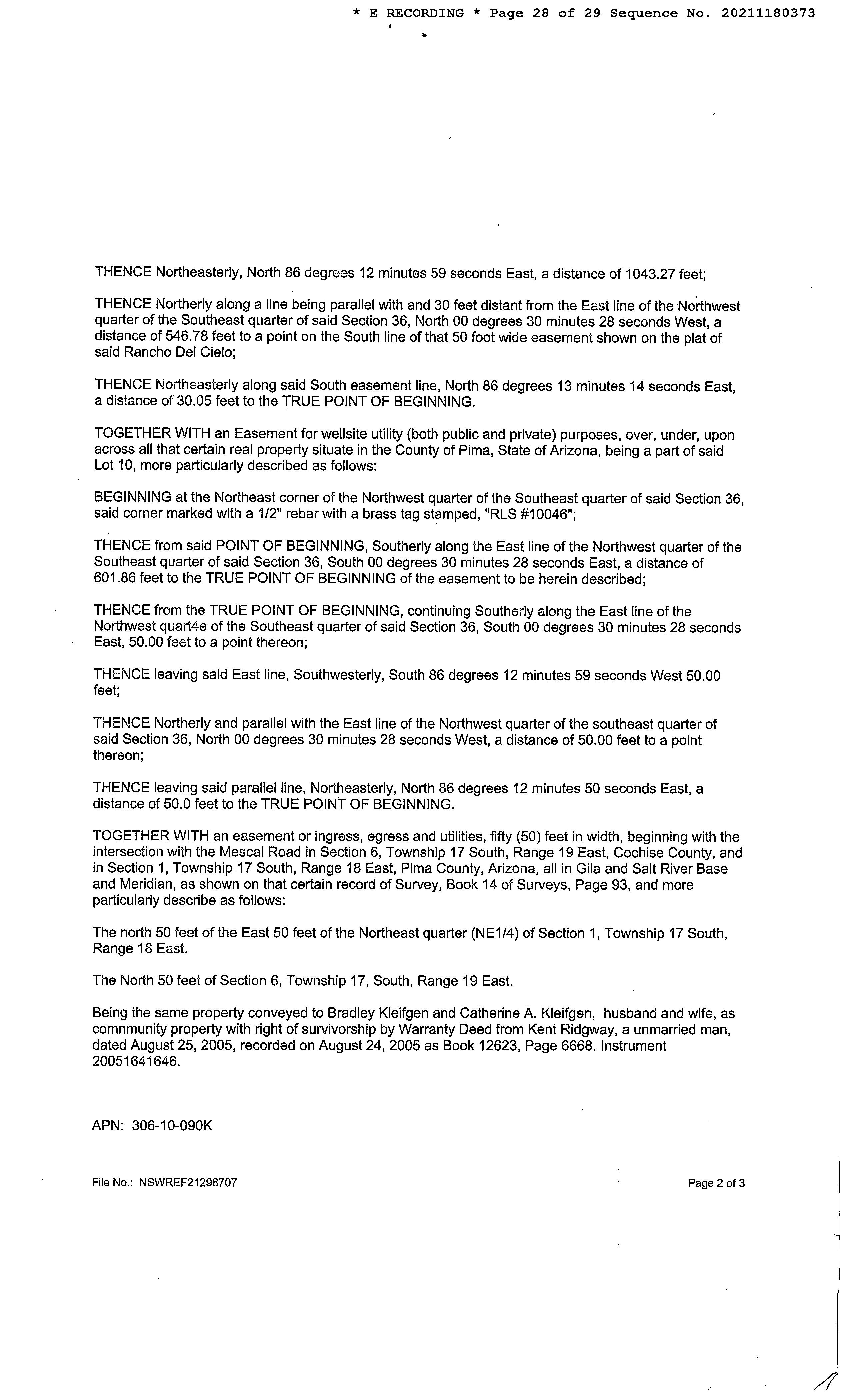
Legal Description : S742.95' E264.37' W528.53' Rancho Del Cielo Rs 16/53 Aka Ptn Nw4 Se4 4.5 Ac Sec 36-16-18
County : Pima, Az
Census Tract / Block : 40.61 / 4
Township-Range- Sect : 16S-18E-36
Legal Lot : 10
Market Area : 620
Owner Transfer Information
Recording/Sale Date : 04/28/2021 / 03/12/2021
APN : 306-10-090K
Subdivision : D Rho Del Cielo
Map Reference : 36-16S-18E
School District : Vail
Munic/Township : Vail
Deed Type : Affidavit
Document # : 1180372 1st Mtg Document # : 1180373
Last Market Sale Information
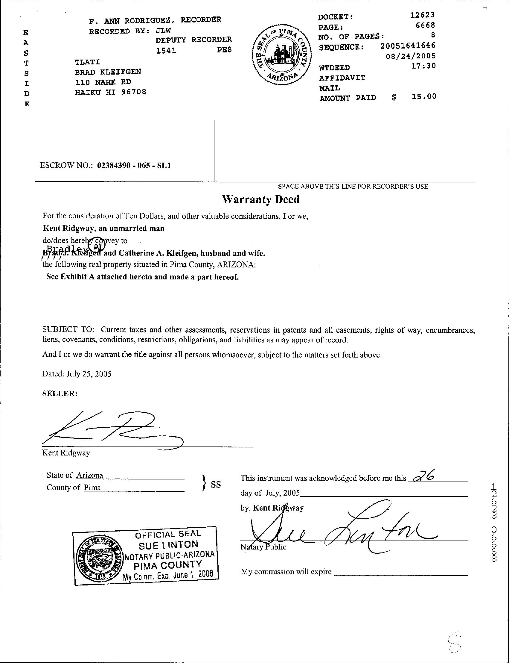
Recording/Sale Date : 08/24/2005 / 06/00/2005 1st Mtg Amount/Type : $117,300 / Cnv
Sale Price : $138,000 1st Mtg Int. Rate/Type : / Fixed Rate Loan
Document # : 12623-6668
1st Mtg Document # : 12623-6676
Deed Type : Warranty Deed 1st Mtg Term : 30
Title Company : Lawyers Title
Lender : Option One Mtg Corp

Seller Name : Ridgway Kent
Prior Sale Information
Prior Rec/Sale Date : 07/05/2002 / 06/00/2002
Prior Sale Price : $40,000
Property Characteristics
Year Built / Eff : 1999 / 1999 # of Stories : 1
Prior Doc Number : 1290540
Prior Deed Type : Agreement Of Sale
Construction : Steel/wood
Customer
: First
Insurance Company Prepared On
07/31/2023 © 2023 CoreLogic. All rights reserved
Customer Name : Lisa Mrazek
Company Name
American Title
:
Property Information Land Use : Mobile Home Zoning : RH Lot Size : 196,020 County Use : Mh Non Subd Lot-affixed Mf Hm Lot Acres : 4.50 State Use : Mh Non Subd Lot-affixed Mf Hm Tax Information Total Value : $79,378 Property Tax : $971.46 Current Year Total Value : $11,254 Total Taxable Value : $7,104 Tax Rate Area : 2006 Current Year Improvement Value : $3,354 Assessed Year : 2022 Market Value : $79,378 Current Year Land Value : $7,900 Tax Year : 2022 Current Assessed Year : 2024
07/31/2023 © 2023 CoreLogic.
rights reserved
Customer
Name : Lisa Mrazek Customer Company Name : First American Title Insurance Company Prepared On :
All

Sales Analysis Criteria Subject Property Low High Average Sale Price $138,000 $34,900 $324,900 $189,600 Bldg/Living Area Price Per Square Foot Year Built 1999 1973 2005 1991 Lot Size 196,020 44,329 303,613 177,098 Bedrooms Bathrooms Stories 1 1 1 1 Total Assessed Value $79,378 $22,589 $101,719 $66,440 Distance From Subject 0 1.01 9.87 5.28
Customer
: First American Title Insurance Company Prepared On : 07/31/2023 © 2023 CoreLogic. All rights reserved
Customer Name : Lisa Mrazek
Company Name
Customer Name : Lisa Mrazek
Customer Company Name : First American Title Insurance Company Prepared On : 07/31/2023
© 2023 CoreLogic. All rights reserved
Map
Customer Name : Lisa Mrazek
Customer Company Name : First American Title Insurance Company Prepared On : 07/31/2023
© 2023 CoreLogic. All rights reserved
 Subject Property : 14187 S Dusty Springs Pl Benson AZ 85602
Customer Name : Lisa Mrazek
Customer Company Name : First American Title Insurance Company Prepared On : 07/31/2023 © 2023 CoreLogic. All rights reserved

14199 S DUSTY SPRINGS PL Distance 0.05 Miles
Owner Name : Wozniak Dennis
Sale Date : 12/00/2003
Total Value : $112,428
Recording Date : 01/06/2004
Sale Price : $39,900
Property Tax : $1,442.20
Land Use : Mobile Home Lot Acres : 4.50
Stories : 1 Living Area : 2,128
Yr Blt / Eff Yr Blt : 2002 / 2002
Subdivision : Rancho Del Cielo Prcl 10
APN : 306-10-090J
14175 S DUSTY SPRINGS PL Distance 0.05 Miles
Owner Name : Flores Robin Subdivision : Del Ceilo Rho
Sale Date : 01/04/2018
Total Value : $263,036
Recording Date : 01/10/2018
Sale Price : $190,000
Bed / Bath : / 3 Property Tax : $3,340.14
Land Use : Sfr Lot Acres : 4.50
Stories : 1
Yr Blt / Eff Yr Blt : 2006 /
Living Area : 1,600
APN : 306-10-090M
14163 S DUSTY SPRINGS PL Distance 0.1 Miles
Owner Name : Martin-morlock Family Trust

Sale Date : 02/00/2006
Total Value : $90,011
Subdivision : Del Cielo Rho
Recording Date : 03/17/2006
Sale Price : $180,000
Land Use : Mobile Home Property Tax : $1,132.77
Stories : 1
Yr Blt / Eff Yr Blt : 2004 / 2004
Lot Acres : 4.51
APN : 306-10-090L
14184 S DUSTY SPRINGS PL Distance 0.13 Miles
Owner Name : Martin Benjamin L Subdivision : Del Cielo Rho
Sale Date : 09/08/2020
Total Value : $111,024
Recording Date : 09/11/2020
Sale Price : $235,500
Land Use : Mobile Home Property Tax : $1,433.36
Stories : 1
Yr Blt / Eff Yr Blt : 2004 / 2004
Lot Acres : 4.50
APN : 306-10-090C
Name : Lisa Mrazek Customer Company Name : First American Title Insurance Company Prepared On : 07/31/2023
© 2023 CoreLogic. All rights reserved
Customer
14196 S DUSTY SPRINGS PL Distance 0.13 Miles
Owner Name : C F Subdivision : Del Cielo Rho
Sale Date : 02/21/2022
Total Value : $78,790
Recording Date : 03/07/2022
Sale Price : $215,000
Land Use : Mobile Home Property Tax : $1,082.06
Stories : 1
Yr Blt / Eff Yr Blt : 2004 / 2004
Lot Acres : 4.50
APN : 306-10-090D
14151 S DUSTY SPRINGS PL Distance 0.15 Miles
Owner Name : Wittmann Joseph Justin
Sale Date : 04/26/2002
Recording Date : 04/29/2002
Sale Price : $39,900
Total Value : $257,787 Property Tax : $3,375.70
Bed / Bath : / 2
Lot Acres : 4.73
Land Use : Sfr Living Area : 1,518
Stories : 1
Yr Blt / Eff Yr Blt : 2008 /
APN : 306-10-090G
25212 E OLD DUSTY TRL Distance 0.16 Miles
Owner Name : Ferguson James Subdivision : Del Cielo Rho
Sale Date : 06/02/2022
Total Value : $85,677
Land Use : Mobile Home
Stories : 1
Yr Blt / Eff Yr Blt : 1999 / 1999
Recording Date : 06/06/2022
Sale Price : $287,000
Property Tax : $1,069.54
Lot Acres : 4.50
APN : 306-10-090B
25077 E OLD DUSTY TRL Distance 0.16 Miles
Owner Name : Philori Properties Llc
Sale Date : 06/28/2010
Total Value : $33,000
Land Use : Residential Acreage
Subdivision : Del Cielo Rho
Recording Date : 06/30/2010
Sale Price : $65,000
Property Tax : $707.07
Lot Acres : 4.20
APN : 306-10-089K
Customer Name : Lisa Mrazek
Customer Company Name : First American Title Insurance Company Prepared On : 07/31/2023
© 2023 CoreLogic. All rights reserved

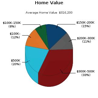
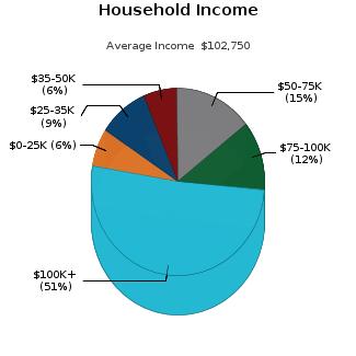
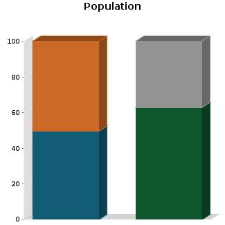
Census Tract / block: 40.61 / 4 Year: 2020 Household Population Population by Age Count: 4,807 0 - 11 Estimate Current Year: 4,617 12 - 17 Estimate in 5 Years: 3,928 18 - 24 9.26% Growth Last 5 Years: -8.43% 25 - 64 46.77% Growth Last 10 Years: -127.77% 65 - 74 12.71% 75+ Household Size Household Income Current Year: 1,757 0 - $25,000 6.49% Average Current Year: 2.74 $25,000 - $35,000 9.33% Estimate in 5 Years: 1,354 $35,000 - $50,000 6.2% Growth Last 5 Years: -5.12% $50,000 - $75,000 14.63% Growth Last 10 Years: 16.75% $75,000 - $100,000 11.9% Male Population: 49.72% Above $100,000 51.45% Female Population: 50.28% Average Household Income: $102,750 Married People: 62.86% Unmarried People: 37.14% Housing Median Mortgage Payments Home Values Under $300: 8.58% Below $100,000: 12.46% $300 - $799: 19.47% $100,000 - $150,000: 7.64% $800 - $1,999: 42.77% $150,000 - $200,000: 15.4% Over $2,000: 29.18% $200,000 - $300,000: 11.21% Median Home Value: $316,200 $300,000 - $500,000: 33.06% Unit Occupied Owner: 90.89% Above $500,000: 20.23% Median Mortgage: $1,318
©
reserved
Customer Name : Lisa Mrazek Customer Company Name : First American Title Insurance Company Prepared On : 07/31/2023
2023 CoreLogic. All rights
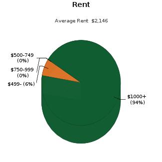
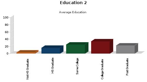
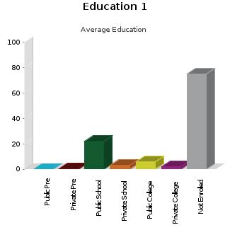
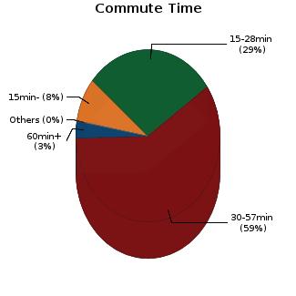
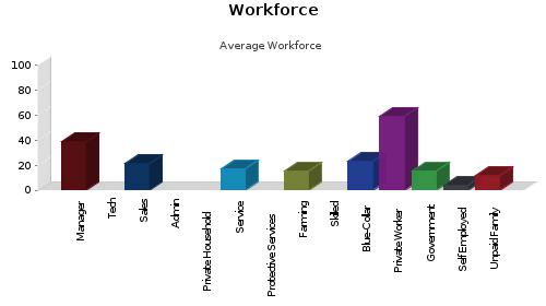
Rent Payments Year Built Unit Occupied Renter: 9.11% 1999 - 2000 Median Gross Rent: $2,146 1995 - 1998 Less Than $499 6.47% 1990 - 1994 $500 - $749 0% 1980 - 1989 8.41% $750 - $999 0% 1970 - 1979 2.01% $1000 and Over 93.53% 1900 - 1969 0.88% Education Enrollment Public Pre-Primary School: 0% Not Enrolled in School: 75.37% Private Pre-Primary School: 0.49% Not A High School Graduate: 2.68% Public School: 21.79% Graduate Of High School: 15.54% Private School: 2.84% Attended Some College: 25.17% Public College: 5.78% College Graduate: 34.05% Private College: 1.73% Graduate Degree: 22.56% Workforce Occupation: Manager/Prof: 38.73% Private Worker: 59.38% Technical: Government Worker: 15.16% Sales: 21.22% Self Employed Worker: 3.61% Administrative: Unpaid Family Worker: 11.6% Private House Hold: Farming: 15.63% Service: 17.09% Skilled: Protective Services: Blue-Collar: 22.95% Commute Time Less Than 15 Min: 8.34% 15 min - 28 min: 29.2% 30 min - 57 min: 59.23% Over 60 min: 3.22% Customer Name : Lisa Mrazek Customer Company Name : First American Title Insurance Company Prepared On : 07/31/2023 © 2023 CoreLogic. All rights reserved
Customer Name : Lisa Mrazek
Customer Company Name : First American Title Insurance Company Prepared On : 07/31/2023
© 2023 CoreLogic. All rights reserved
Customer Name : Lisa Mrazek
Customer Company Name : First American Title Insurance Company Prepared On : 07/31/2023
© 2023 CoreLogic. All rights reserved
Customer Name : Lisa Mrazek
Customer Company Name : First American Title Insurance Company Prepared On : 07/31/2023
© 2023 CoreLogic. All rights reserved


Arizona Schools For detailed information and statistics on Arizona schools please go to https://azreportcards.azed.gov/ First American Title Insurance Company, and the operating divisions thereof, make no express or implied warranty respecting the information presented and assume no responsibility for errors or omissions. First American, the eagle logo, First American Title, and firstam.com are registered trademarks or trademarks of First American Financial Corporation and/or its affiliates. ©2021 First American Financial Corporation and/or its affiliates. All rights reserved. NYSE: FAF 05117910421
PIMA COUNTY
School District Information
This map is provided for general location only. Please contact school districts for actual street boundaries
05249570321 TUCSON INT'L AIRPORT Air Force WSilverbellRd SSantaRitaRd N M t L emmon Hwy ESascoRd NF38 W Avra Valley Rd E Grand Va ey Dr NAguirre R d N L u c k e R d N W e n t z R d N Wa terman Mounta i n R d N Anway Rd W El Tiro Rd N Trico Rd W Tucker Rd W Rudas l Rd W Manvi e Rd SSanJoaquinRd WBopp Rd W Snyder H l Rd S M a r s e a r R d W Park Rd W Hermans Rd W Hermans Rd W Guy St W Bush Rd S G a v e y R d N C a e R i n c o n a d o S W m o R d S Shaw Rd S Sierrita Mountain Rd S K o b R d W TwinButtes Rd W Mcgee Ranch Rd S E s t a n c a D r EDesertDove E Hemlock Dr N Bea r C a n y o n R d W E Camino Del Cerro E Fairmount St S Swan Rd NFrontageRd W Emigh Rd W Fort Lowe Rd N P u m p S t a t ion dR E Nona Rd Ch efButteRd Lo al Ave N Trico Rd S Cattle Tank Rd Evalyn Rd SOwlHead R a n c h Rd GasLineRd S P ec a n R d N T r c o R d W Bayard Rd S S a n d a r o R d W i l l owSpri n gsRd N Dove Mountain Blvd SHelvetiaRd WAnamax Mine Rd W G a c i a R a n hc R d Road424 WRagged Top Rd W Ruby Star Dr WBritten RanchRd W Pima Mine Rd S Mcgee Ranch R d E Edw n Rd SGuildRd 8 0 NKINNEYRD S PICACHO HWY E BAUMGARTNER RD N S A N D A R I O R D N ANWAY RD W VALENCIA RD W MOORE RD W INA RD N 1 S T A V E E SUNRISE DR E SNYDER RD NSILVERBELLRD N S O L D I E R T R L E RIVER RD E PRINCE RD E SPEEDWAY BLVD S FREEMAN RD E 22ND ST E 22ND ST W IRVINGTON RD S N O G A L E S H W Y W VALENCIA RD SMISSIONRD W SPEEDWAY BLVD S O L D S P A N I S H T RL W NARANJA DR W TWIN PEAKS RD W PICTURE ROCKS RD W MANVILLE RD SKINNEYRD W MILE WIDE RD E SAHUARITA RD N TRICO RD S S A N D A R O R D PARK LINK DR S OLD N O G ALES HW Y S H O U G H T O N R D S L A C A N A D A DR W HELMET PEAK RD WAJOHWY N S W A N R D S KOLB RD S HOUGHTON RD W TANGERINE RD E GRANT RD S H O U G H T O N R D 9 5 WAJOHWY E VALENCIA RD NORACLE R D I10 I-19 77 77 77 86 86 286 10 19 10 10 Corona de Tucson Casas Adobes Catalina Green Valley Oracle Picture Rocks Three Points Vail Summit Tanque Verde Tucson Sahuarita Red Rock Saddlebrooke Marana Oro Valley Rillito Summerhaven Willow Canyon Oracle Junction Cortaro Continental Littletown 20 30 13 15 51 39 12 01 01 08 10 16 11 06
SCHOOL DISTRICTS 15 AJO UNIFIED 111 N. Well Road, Ajo, AZ 85321 520.387.5618 51 ALTAR VALLEY ELEMENTARY 10105 S. Sasabe Road, Tucson, AZ 85736 520.822.1484 10 AMPHITHEATER UNIFIED 701 W. Wetmore, Tucson, AZ 85705 520.696.5000 16 CATALINA FOOTHILS UNIFIED 2101 E. River Road, Tucson, AZ 85718 520.209.7500 39 CONTINENTAL ELEMENTARY 1991 E. Whitehouse Canyon, Green Valley, AZ 85614 520.625.4581 08 FLOWING WELLS UNIFIED 1556 W. Prince Road, Tucson, AZ 85705 520.696.8800 06 MARANA UNIFIED 11279 W. Grier Road, Marana, AZ 85653 520.682.3243 11 PIMA COUNTY JTED 2855 W. Master Pieces Dr, Tucson, AZ 85741 520.352.5833 30 SAHUARITA UNIFIED 350 W. Sahuarita Road, Sahuarita, AZ 85629 520.625.3502 12 SUNNYSIDE UNIFIED 2238 E. Ginter Road, Tucson, AZ 85706 520.545.2000 13 TANQUE VERDE UNIFIED 2300 N. Tanque Verde Loop, Tucson, AZ 85749 520.749.5751 01 TUCSON UNIFIED 1010 E. 10th Street, Tucson, AZ 85717 520.225.6000 20 VAIL UNIFIED 10701 E. Mary Ann Cleveland Way, Tucson, AZ 85747 520.879.2000 First American Title Insurance Company, and the operating divisions thereof, make no express or implied warranty respecting the information presented and assume no responsibility for errors or omissions. First American, the eagle logo, First American Title, and firstam.com are registered trademarks or trademarks of First American Financial Corporation and/or its affiliates. ©2021 First American Financial Corporation and/or its affiliates. All rights reserved. NYSE: FAF
SEARCH PARAMETERS
PARCEL: 306-10-090K
PARCEL: 306-10-090K
OWNER: KLEIFGEN BRADLEY & CATHERINE A CP/RS
SITUS: 14187 S DUSTY SPRINGS PL PC
MAIL: 14187 S DUSTY SPRINGS PL
BENSON AZ 85602-5621
LEGAL: S742.95' E264.37' W528.53' RANCHO DEL CIELO RS 16/53 AKA PTN NW4 SE4 4.5 AC SEC 36-16-18
NO SALES
ADDITIONAL PROPERTY INFORMATION
STANDARD LAND USE: MOBILE HOME LOT
END SEARCH
07/31/2023 02:12PM RL13 INVESTIGATIVE SEARCH RESULTS PAGE 1 OF 1
+ FIRST AMERICAN TITLE, FC0, LMRA PIMA, AZ
INSTRUMENT REC DATE
12623 6668 08/24/2005
CURRENT TAXES INFORMATION THROUGH 06/28/2023 LAND IMPR EXEMPT RATE AREA SPECIAL DISTRICTS PRIMARY 7,104 0 0 8.8997 2006 SECONDARY 4,700 3,238 0 6.4883 2022 TOTAL TAX BILLED 971.46 2022 TAX AMT TAX DUE INTEREST DATE PAID TOTAL DUE FIRST HALF 485.73 0.00 0.00 10/24/2022 0.00 SECOND HALF 485.73 0.00 0.00 04/24/2023 0.00 TOTAL CURRENT TAXES DUE 07/23 0.00 08/23 0.00 IMPROVEMENTS MOBILE HOME BLDG SQFT 0 FULL CASH VALUE 79,378 YEAR BUILT 1999 LAND USE 08 39 NUMBER OF STORIES 1.0 LOT SIZE 4.500 ACRES STORIES HEIGHT 0 SCHOOL DISTRICT 2006 EXTERIOR WALLS LAND FULL CASH VALUE 47,000 GRADE MATERIALS IMPR FULL CASH VALUE 32,378 SALES
Page 1 of 6 07/31/2023 2:17 PM
Page 2 of 6 07/31/2023 2:17 PM
Page 4 of 6 07/31/2023 2:17 PM
Page 5 of 6 07/31/2023 2:17 PM
Page 6 of 6 07/31/2023 2:17 PM
Page 1 of 29 07/31/2023 2:17 PM
Page 2 of 29 07/31/2023 2:17 PM
Page 3 of 29 07/31/2023 2:17 PM
Page 4 of 29 07/31/2023 2:17 PM
Page 5 of 29 07/31/2023 2:17 PM
Page 6 of 29 07/31/2023 2:17 PM
Page 7 of 29 07/31/2023 2:17 PM
Page 8 of 29 07/31/2023 2:17 PM
Page 9 of 29 07/31/2023 2:17 PM
Page 10 of 29 07/31/2023 2:17 PM
Page 11 of 29 07/31/2023 2:17 PM
Page 12 of 29 07/31/2023 2:17 PM
Page 13 of 29 07/31/2023 2:17 PM
Page 14 of 29 07/31/2023 2:17 PM
Page 15 of 29 07/31/2023 2:17 PM
Page 16 of 29 07/31/2023 2:17 PM
Page 17 of 29 07/31/2023 2:17 PM
Page 18 of 29 07/31/2023 2:17 PM
Page 19 of 29 07/31/2023 2:17 PM
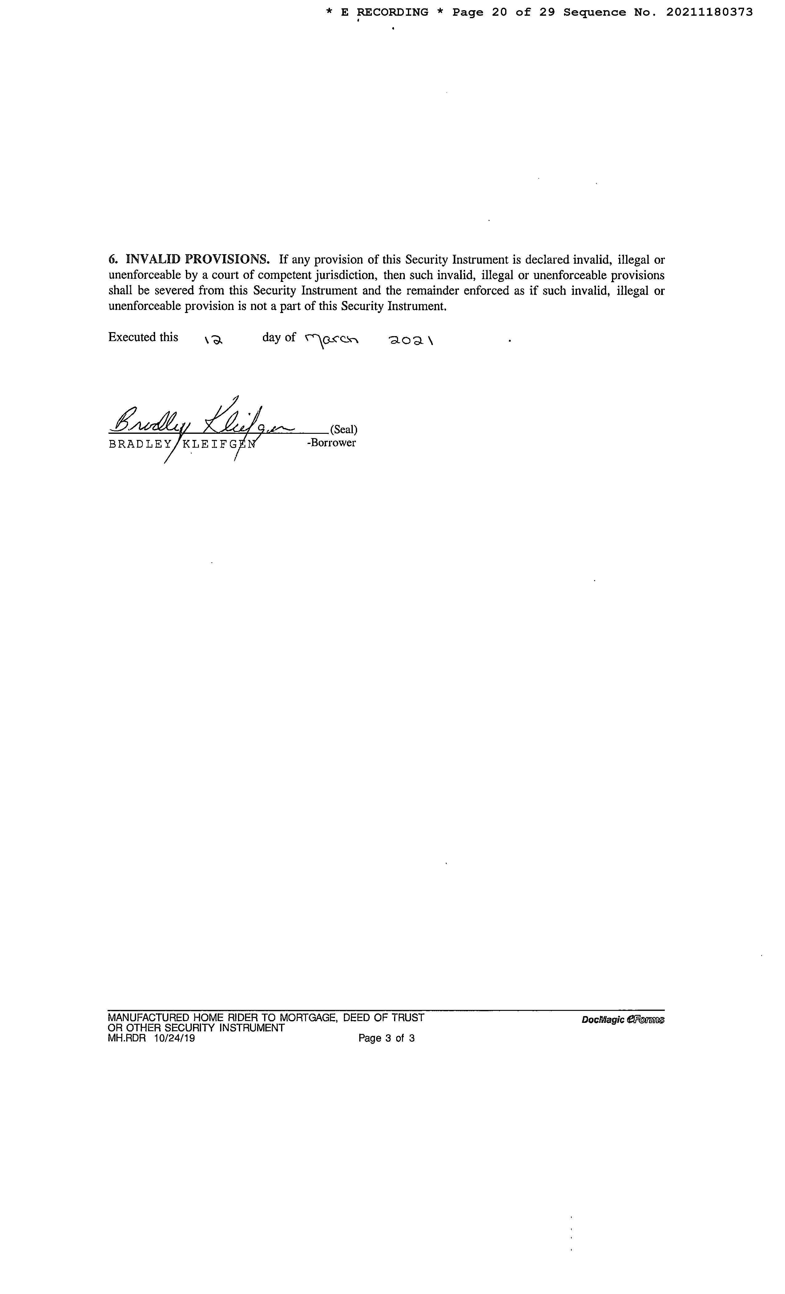
Page 20 of 29 07/31/2023 2:17 PM
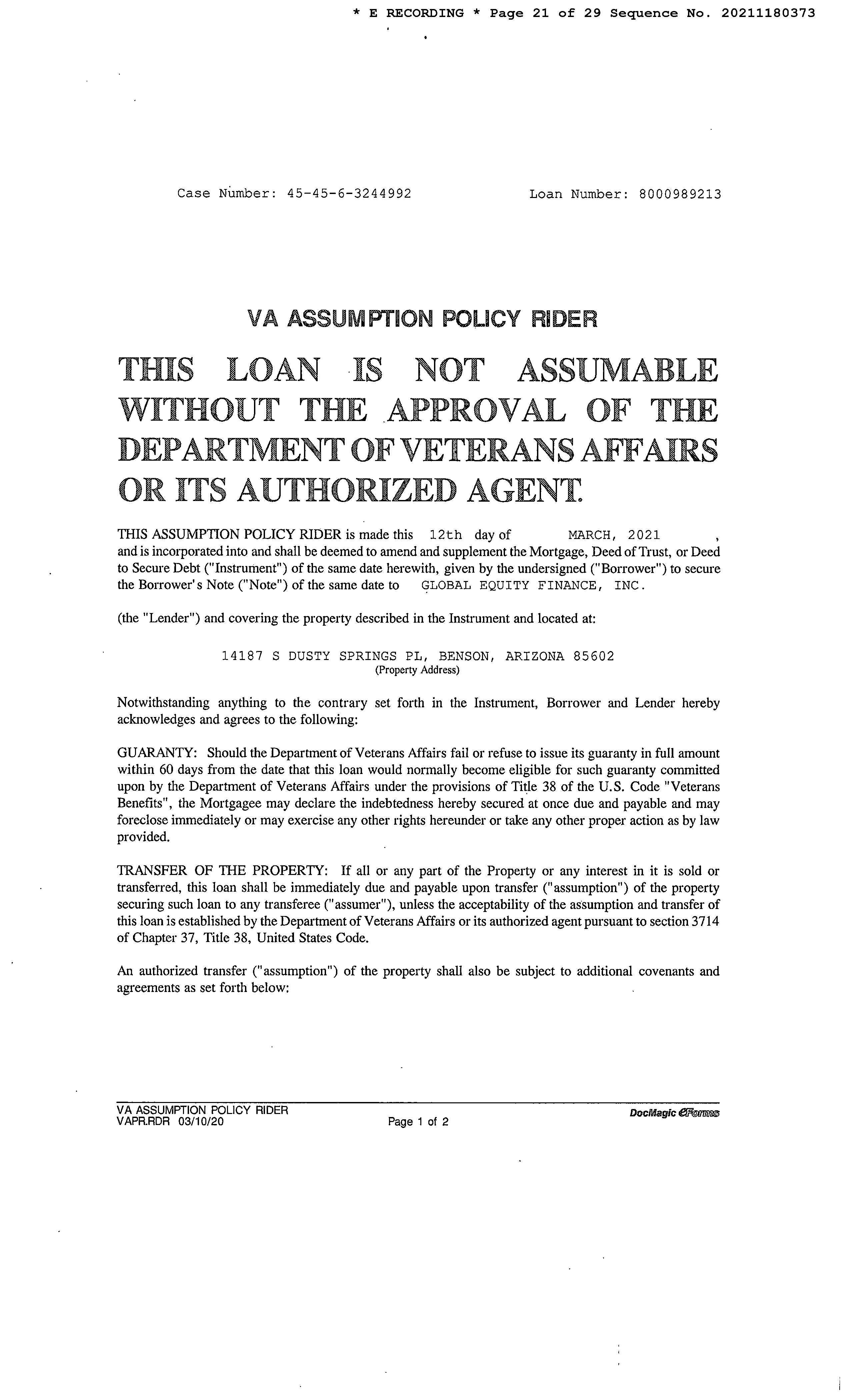
Page 21 of 29 07/31/2023 2:17 PM
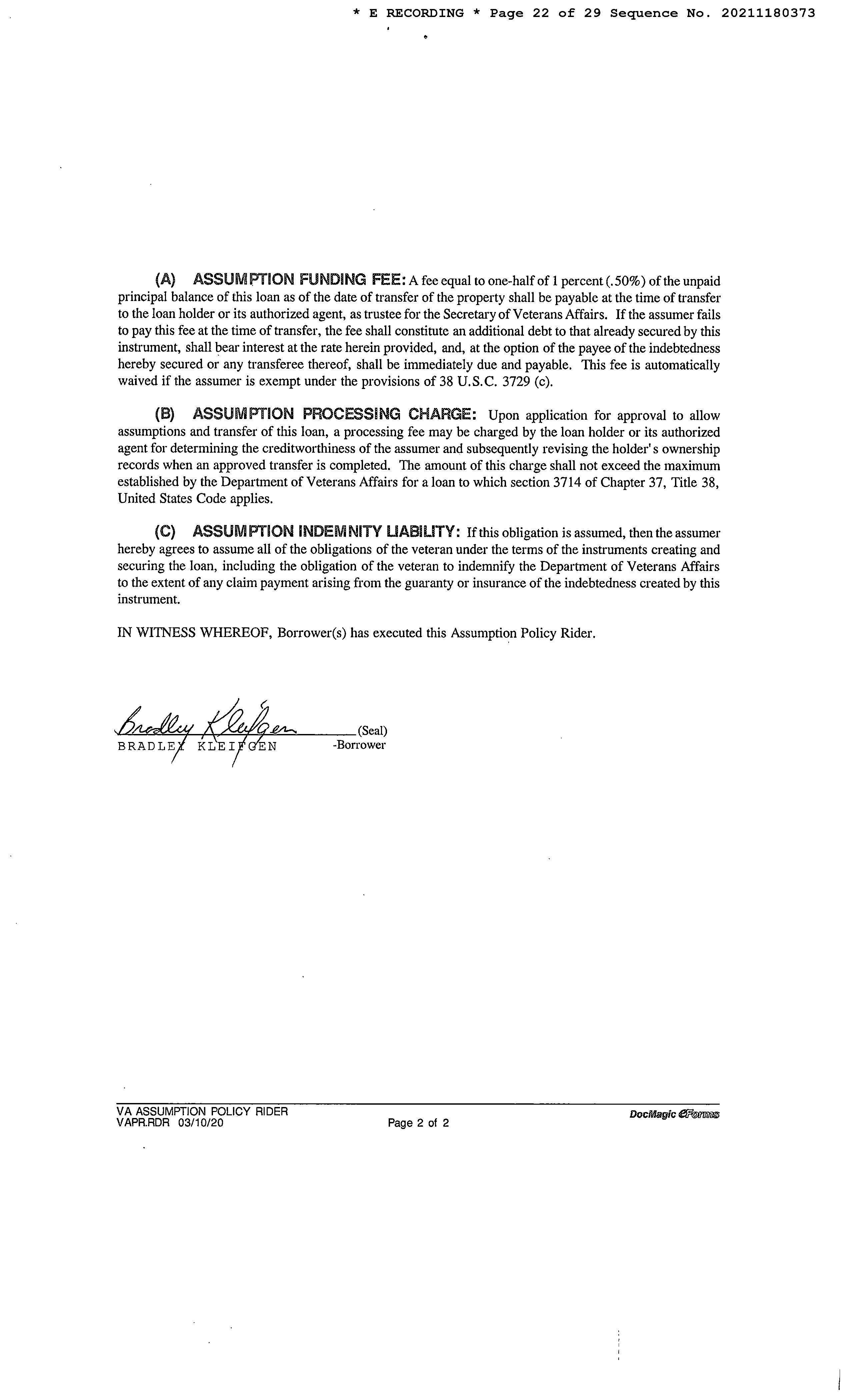
Page 22 of 29 07/31/2023 2:17 PM
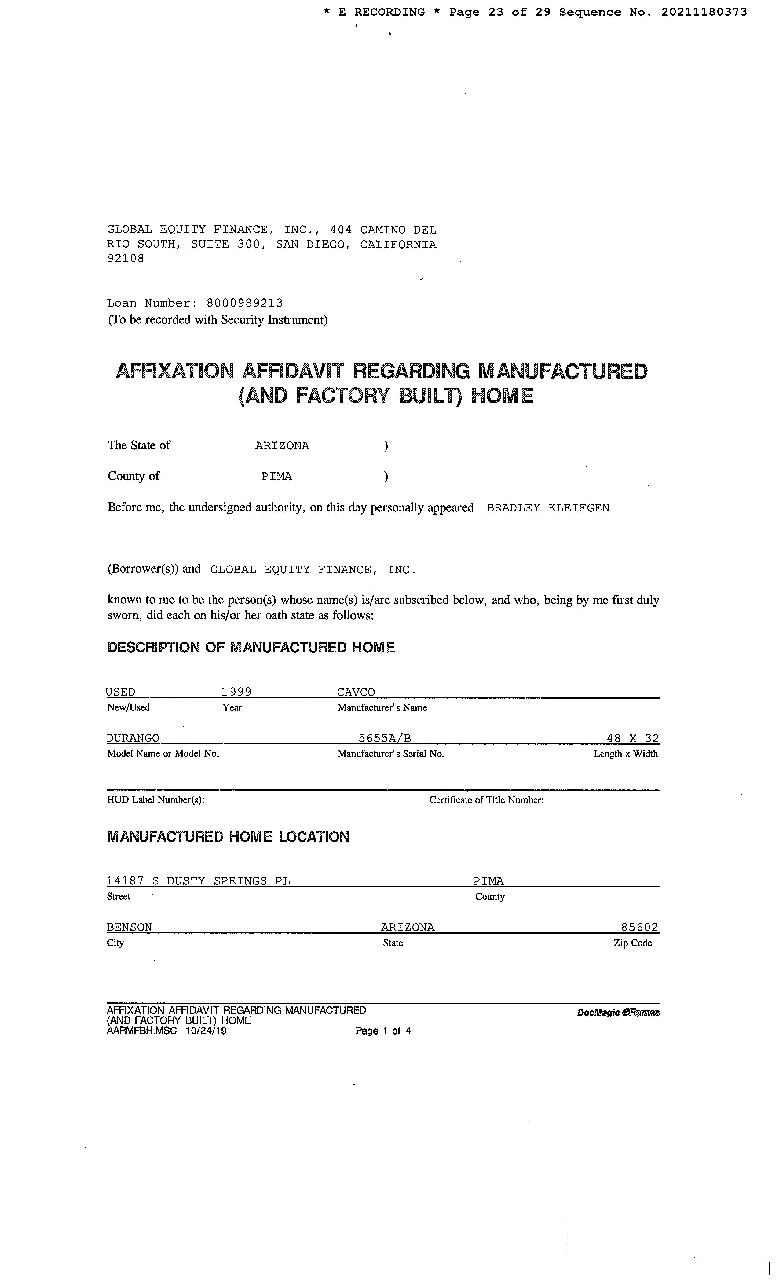
Page 23 of 29 07/31/2023 2:17 PM
Page 24 of 29 07/31/2023 2:17 PM
Page 25 of 29 07/31/2023 2:17 PM
Page 26 of 29 07/31/2023 2:17 PM
Page 27 of 29 07/31/2023 2:17 PM
Page 28 of 29 07/31/2023 2:17 PM
Page 29 of 29 07/31/2023 2:17 PM
Page 1 of 4 07/31/2023 2:17 PM
Page 2 of 4 07/31/2023 2:17 PM
Page 3 of 4 07/31/2023 2:17 PM
Page 4 of 4 07/31/2023 2:17 PM