
VICTORIAN CIVIL AND ADMINISTRATIVE TRIBUNAL
PLANNING AND ENVIRONMENT LIST
CATCHWORDS
VCAT REFERENCE NO. P1295/2023
PERMIT APPLICATION NO. 907/2022/03P
Nillumbik Planning Scheme; assessment of the impact on an adjoining heritage place; medium density development in the Mixed Use Zone; policies guiding the location of medium density housing at Clauses 02.03-6 and 16.01-1L of the Nillumbik Planning Scheme; Eltham Gateway precinct; Schedule 1 to the Design and Development Overlay in the Nillumbik Planning Scheme; Eltham Gateway Design Guidelines (Hansen Partnership, March 2013); landscape character assessment where the Environmental Significance Overlay and Significant Landscape Overlay apply; internal amenity associated with expansive communal facilities in a cohousing project.
APPLICANT
Brougham Street Cohousing Pty Ltd
RESPONSIBLE AUTHORITY Nillumbik Shire Council
REFERRAL AUTHORITY Melbourne Water
RESPONDENTS
SUBJECT LAND
HEARING TYPE
Eltham Community Action Group Inc and others
Diane Bullen
Part of the land at 62A Brougham Street Eltham contained within Lot 1 on Plan of Subdivision 806147B in Certificate of Title Volume 12143 folio 267, being that part of the land within the Mixed Use Zone
Major Case Hearing
DATE OF HEARING 8, 9 & 10 April 2024
DATE OF ORDER 22 April 2024
CITATION
Brougham Street Cohousing Pty Ltd v Nillumbik SC [2024] VCAT 360
ORDER
1 Pursuant to clause 64 of Schedule 1 of the Victorian Civil & Administrative Tribunal Act 1998, the permit application is amended by substituting for the permit application plans, the following plans filed with the Tribunal:
• Prepared by: DKO Architecture (Development plans)
• Drawing numbers: Cover Page, TP001 to TP004, TP100 to TP102, TP200 to TP207, TP300 to TP307,

TP309, TP310, TP400 to TP406, TP500 to TP502, TP600 to TP606
• Dated: 16 February 2024 (Revision 04)
• Prepared by: Realm Studios (Landscape plans)
• Drawing numbers: L101 to L105
• Dated: 15 February 2024 (Revision G, except that plan L105 is marked Revision H)
2 In application P1295/2023 the decision of the responsible authority is set aside.
3 In planning permit application 907/2022/03P a permit is granted and directed to be issued for the land at 62A Brougham Street Eltham in accordance with the endorsed plans and the conditions set out in Appendix A. The permit allows:
• To construct two or more dwellings on a lot
• To construct a building and construct or carry out works
• To construct a fence
• To remove vegetation
• To partly demolish a building
Micheal Deidun Stephen Axford Member Member
For applicant
APPEARANCES
Dominic Scally, Solicitor of Best Hooper
He called the project architect, Jesse Linardi of DKO Architecture, to describe the plans at the commencement of the hearing
He called the following expert evidence:
• Damian Iles, Town Planner of Hansen Partnership
• Craig Czarny, Urban Designer and Landscape Architect of Hansen Partnership
• Kylie May, Arborist of John Patrick Landscape Architects
He also circulated lay evidence from the following people, who were not called to give oral evidence:
• Elise Maynard
• Teresa Dominik
• Ross Wade
For responsible authority
James Livingston, Town Planner of JLP Melbourne
For referral authority No appearance
For respondents
Carlota Quinlan appeared on Days 1 & 2, and Jill Chan appeared on Day 3, on behalf of the joint respondents lead by the Eltham Community Action Group Inc
Diane Bullen appeared in person on Day 1 of the hearing only
Description of proposal
Nature of proceeding
Planning scheme
Zone and overlays
The construction of 21 dwellings, in a series of buildings across the land, that are either two or three storeys in height. Formally, the proposal is described in the following manner:
Buildings and works to construct dwellings, fences and decks within that part of the Land located within the Mixed Use Zone, under the MUZ, Design and Development Schedule 1, Environmental Significance Overlay Schedule 1, Heritage Overlay Schedule 17 and Significant landscape Overlay Schedule 7 and removal of vegetation under the SLO7 and partial demolition of existing buildings under the HO17
Application under section 77 of the Planning and Environment Act 1987 – to review the refusal to grant a permit.
Nillumbik Planning Scheme
Mixed Use Zone
Design and Development Overlay 1
Environmental Significance Overlay 1
Heritage Overlay 17 (part)
Land Subject to Inundation Overlay (part)
Significant Landscape Overlay 7 (part)
Permit requirements
Relevant scheme policies and provisions
Land description
Tribunal inspection
Clause 32.04-7 to construct two or more dwellings on a lot on land within the Mixed Use Zone
Clause 42.01-2 to construct a building, construct or carry out works, and construct a fence on land to which the Environmental Significance Overlay applies
Clause 42.03-2 to construct a building, construct or carry out works, construct a fence, and removal of vegetation on land to which the Significant Landscape Overlay applies
Clause 43.01-2 to partly demolish a building, and to construct a building and construct or carry out works on land to which the Heritage Overlay applies
Clause 43.02-2 to construct a building and construct or carry out works on land to which the Design and Development Overlay applies
Clause 44.04-2 to construct a building and construct or carry out works (including a fence and decks) on land to which the Land Subject to Inundation Overlay applies
Clauses 02, 11, 12, 13, 14, 15, 16, 32.04, 37.03, 42.01, 42.03, 43.01, 43.02, 44.04, 52.06, 55, 65 and 71.02.
The land is an irregular shaped allotment with a frontage to Brougham Street of 48.7 metres, and an overall area of 4698 square metres (being that area within the Mixed Use Zone) The site also has access to 1923 square metres of land within the Urban Floodway Zone. The land presently supports a shop, café and a landscape design studio.
The Tribunal conducted an unaccompanied inspection of the site and surrounding area on 11 April 2024.
REASONS1
INTRODUCTION
1 This case provides an exemplar of an innovative approach to dealing with the challenge of providing more diverse housing opportunities to meet the needs of all Victorians.
2 In 2021 a group of people formed a housing co-operative and decided the best way to tackle housing supply and affordability was to purchase a site and develop a series of dwellings around a plethora of communal facilities. In short, this group of people decided to take action to solve their own housing affordability issues.
3 This was by no means a half-baked idea. Instead, the group engaged highly respected professionals in a range of fields, including architecture, to design a series of dwellings that responded to the site’s constraints in an informed and clever manner. In a system where a development only needs to meet an appropriate or reasonable standard in order to gain a planning permit, it is our view that this proposal goes well beyond such measures. We have found that the proposal is an excellent response to its context both in terms of policy and its physical context. In summary, this is because:
a. The proposed development is contained on land within the Mixed Use Zone, which is intended to support higher residential densities, and in a location in which medium density housing is strongly encouraged by policy in the local planning scheme.
b. It has managed its interfaces so that from the public realm there will be minimal change, and arguably the streetscape will be improved.
c. It limits impacts upon its neighbours with effective site planning and additional landscaping.
d. It incorporates innovative architecture with a contemporary interpretation of what could be described as the Eltham style.
e. And perhaps most importantly, it involves a community focussed approach that minimises private space in favour of communal open space and facilities, and produces a housing opportunity that is presently not available in a location known for its sense of community and architectural innovation.
4 The proposed addresses the call for diversity in housing supply that is one of the key planks of the Nillumbik Planning Scheme. In our view, this is a project that could and should have been supported and fast tracked because of the qualities we have outlined above. That instead this project was met
1 The submissions and evidence of the parties, any supporting exhibits given at the hearing and the statements of grounds filed have all been considered in the determination of the proceeding. In accordance with the practice of the Tribunal, not all of this material will be cited or referred to in these reasons.
with substantial delays and opposition, is part of a wider trend we are observing, that will fail to produce appropriate housing projects that can start to address the existing shortfall of housing supply presently being experienced across Metropolitan Melbourne.
5 We find that the concerns of Council in particular arise from a misinterpretation of the role of the Eltham Gateway, and a failure to engage with the communal approach that drives the design.
6 Our detailed reasons for our approach to this proposal are set out in the analysis that follows.
WHAT IS THIS PROCEEDING ABOUT?
7 Brougham Street Cohousing Pty Ltd (the ‘applicant’) seeks to review the decision of the Nillumbik Shire Council (the ‘Council’) to refuse to grant a permit for the construction of 21 dwellings on land at 62A Brougham Street Eltham (the ‘review site’).
8 The application is not an usual housing development, but rather is explained in the Planning report2 that accompanied the planning permit application in the following manner.
The project is a citizen-led development to deliver at-cost housing that has a strong focus on environmental and social sustainability, community, more affordable home ownership and connection to nature. This development project has so far brought together 15 groups of owner-occupiers (referred to as The Brougham Street Collective) to develop the site for their own future housing.
The commercial delivery structure of a Building Group means that members of the Building Group (Brougham Street Cohousing Pty Ltd) are Joint Venturers. The Deed means each Joint Venturer will own one of the dwellings on its separate land title and have a share of the common property at the end of the process.
This model represents an alternative way to deliver more affordable housing which aligns future residents’ wants and needs with the housing product and allows for a sharing of facilities to foster a community connection.
Property Collectives have been successful in delivering this deliberative development housing model in several other locations, such as:
• 4 Strettle Street, Thornbury
• 121 Clarke Street, Northcote
• 488-490 Victoria Street, West Brunswick (currently under construction).
This project is the culmination of over a year of design and technical assessments, with the key drivers of the project being for:
2 62A Brougham Street, Eltham Planning Permit Application (Echelon Planning, October 2022).
• Environmental sustainability,
• Maximisation of permeability and working with the landform,
• Creation of large communal spaces,
• Enhancement of the landscape, providing natural, productive and social spaces for connection,
• Respecting and celebrating heritage values,
• Resilience to flood and bushfire risk, and
• High-quality architecture which enhances the cultural and landscape significance of the Eltham Gateway.
It has considered the environment, landscape and building materiality in detail and seeks to create a development which harmonises these elements.
9 The Council determined to refuse to grant a planning permit for the proposal. The Council’s grounds of refusal raise concerns with elements of the design response and its consistency with Schedule 1 to the Design and Development Overlay (DDO1), the impact on existing trees and insufficient space for new landscaping, non compliance with objectives of Clause 55 and the design of the proposed car parking on site.
10 The Council’s Notice of Refusal also argues that the use and development is prohibited in the Urban Floodway Zone. This issue was addressed at a Practice Day Hearing on 8 December 2023. Subsequently an order was issued by the Tribunal on 11 December 2023 which amended the address of the land, so that the planning unit only comprises the part of the review site that is within the Mixed Use Zone. This effectively deals with the ground of refusal.
11 Prior to the hearing, amended plans were circulated to all parties which sought to address the concerns raised by Council and other parties. In response, the Council maintained its original grounds of refusal.
12 Two Statements of grounds have been filed. One is from a group of joint respondents lead by the Eltham Community Action Group Inc. The other Statement of grounds is from an adjoining resident. In addition to the concerns raised by Council, the respondents raise concerns relating to the suitability of the site to accommodate dwellings given its flooding potential, as well as a range of potential off-site amenity impacts and internal amenity concerns.
13 The issues or questions for determination are:
a. Is the proposal an appropriate response to the heritage place?
b. Is the proposed development an appropriate response to its context?
c. Does the proposal appropriately respond to the flooding constraints on the land?
d. Will there be any unreasonable off-site amenity impacts?
e. Is an appropriate level of internal amenity provided?
f. Does the proposal appropriately provide for car parking and traffic movements?
14 The Tribunal must decide whether a permit should be granted and, if so, what conditions should be applied. Having considered all submissions and evidence presented with regard to the applicable policies and provisions of the Nillumbik Planning Scheme, we have decided to set aside the Council’s decision, and direct the grant of a planning permit subject to conditions Our reasons follow.
IS THE PROPOSAL AN APPROPRIATE RESPONSE TO THE HERITAGE PLACE?
15 Under the decision guidelines set out at Clause 43.01-8 of the Heritage Overlay, we need to have regard to the following matters:
Before deciding on an application, in addition to the decision guidelines in Clause 65, the responsible authority must consider, as appropriate:
• The Municipal Planning Strategy and the Planning Policy Framework.
• The significance of the heritage place and whether the proposal will adversely affect the natural or cultural significance of the place.
• Any applicable statement of significance (whether or not specified in the schedule to this overlay), heritage study and any applicable conservation policy.
• Any applicable heritage design guideline specified in the schedule to this overlay.
• Whether the location, bulk, form or appearance of the proposed building will adversely affect the significance of the heritage place.
• Whether the location, bulk, form and appearance of the proposed building is in keeping with the character and appearance of adjacent buildings and the heritage place.
• Whether the demolition, removal or external alteration will adversely affect the significance of the heritage place.
• Whether the proposed works will adversely affect the significance, character or appearance of the heritage place.
16 It is evident from these decision guidelines that an important starting point is an understanding of what is the significance of the heritage place. The following is what we understand to be the statement of significance for this heritage place.
What is significant?
The entire 1969 studio, including the spiral staircase and wrought metalwork and the shed with its iron gates and the site to a radius of 25 metres.
How is it significant?
The 1969 studio and the shed are architecturally, historically, aesthetically and socially significant to the Shire of Nillumbik. Why is it significant?
The 1969 studio is architecturally, historically and aesthetically significant because it exemplifies the highly creative structures erected in the former Shire of Eltham during the 1960s and 1970s and is one of the two finest small buildings constructed in the Eltham style’(see HO157) (Criteria F, E & D). The shed is historically and aesthetically significant for its unusual iron gates (Criteria E & B). The studio and shed are historically significant because it is associated with Arthur Munday, Peter Garner, Lenore Garner and the Montsalvat artists’ community more broadly (Criterion H).
17 It is evident from this statement of significance that it is the studio and shed that are significant, along with the adjacent setting. The studio and shed are located near to the western boundary of the review site, which has resulted in the Heritage Overlay being placed on part of the review site, and part of the adjoining property to the west of the review site. This is depicted on the following image, extracted from the Heritage report3 lodged with Council during the planning permit application process.
3 Heritage Report: Brougham St Cohousing 62A Brougham Street, Eltham (HO17) (Frontier Heritage Pty Ltd, 13 October 2022).

18
None of the parties that oppose the grant of a planning permit raise any concern in relation to the impact of the proposal on the character and significance of the heritage place. This includes a detailed independent assessment undertaken by Council’s heritage advisor, which supports the grant of a planning permit on heritage grounds
19 It is the evidence of Mr Iles that the proposal is an appropriate response to the character and significance of the heritage place. He forms this view for the following reasons, extracted from his written evidence statement.
84. The review site is partially affected by the Heritage Overlay –Schedule HO17 which relates to the ‘Peter Garner Adobe Studio and Adjacent Shed.’ The Statement of Significance identifies the studio and shed are architecturally, historically, aesthetically and socially significant to the Shire of Nillumbik.
85. Given the above heritage context, I support the proposed partial demolition and buildings and works for the following reasons:
• No works are proposed to the heritage studio and shed, with the exception of internal reconfigurations which do not trigger a permit pursuant to Clause 43.01. In this regard, whilst a permit is not required for internal reconfigurations, I find that the proposed communal use of these buildings (communal storage and communal recreation spaces) is a positive response to Clause 15.031S of the PPF, insofar as supporting the adaptive reuse of heritage buildings where their use has become redundant.
• The proposed partial demolition of buildings and fencing generally north-west is minor and will not have any detrimental impact to the heritage place, noting the affected area is of no heritage significance.
• The proposed new buildings and works are complementary in height, scale, and design having regard to the heritage place and Eltham Gateway environs.
• The siting of buildings provides for ample separation distance from the existing heritage buildings, to protect the heritage place in its own right.
• The proposed materials will not detract from the heritage buildings and are clearly distinguishable from the original built form elements.
20 We are persuaded by the evidence of Mr Iles, and agree that the proposal is an appropriate response to the character and significance of the heritage place. We make this finding for the following reasons:
a. The extent of demolition proposed within the heritage place are to non-heritage buildings, and the existing heritage buildings are to be retained and not altered externally;
b. The proposed new buildings and alterations are substantially set back from the existing heritage buildings, such as to retain an appropriate setting for the heritage buildings, and to enable them to continue to be read in the round;
c. To the extent that limited views to the heritage buildings may currently be gained from the public realm in Brougham Street, the proposed works will not further obscure such views; and,
d. The proposed internal works to the heritage buildings are of no consequence to their character and significance, noting the absence of internal controls applying to this heritage place.
21 Turning our attention away from the heritage place that is found on part of the review site, Ms Bullen makes the following written submission in relation to her adjoining property:
The bulk and dark cladding of the “Treehouse” section of the proposed development, in such close proximity to the whitewashed, heritage listed, mudbrick dwelling at 715 Main Road Eltham, is not sympathetic to this building’s heritage value.
22 The land at 715 Main Road Eltham contains the Saskia Killingbeck house and is within HO228. The Victorian Heritage Database provides the following two statements of significance for this site.
ELTHAM STUDY STATEMENT OF SIGNIFICANCE:
Of relatively recent origins, this building is an example of the picturesque buildings erected in Eltham and elsewhere since the practice was begun at The Robins and particularly Montsalvat in 1912
and 1934 respectively. The so-called Eltham style of these buildings reflects the social attitudes of some residents of the time and is very characteristic of Eltham in the post Second World War period. The adjacent Matcham Skipper studio is a more exotic version of the same style and the two buildings form a significant group with the Jarrold Cottage and also with the Peter Garner house, which is not far away.
REVISED STATEMENT OF SIGNIFICANCE (with AHC criteria):
Saskia Killingbeck house is significant to Eltham:
- as a recent example of the picturesque Old English style adobe buildings erected in Eltham and elsewhere in the Shire since the combination of style and construction type began at Boyd's The Robins and Montsalvat in 1912 and 1934 respectively (Criterion A4,D2);
23 The Statements of significance identify that the significance of HO228 is attributed to the architectural style of the dwelling that exists on that site. The Statements of significance do not attribute any significance to the setting of the dwelling, that is the gardens that surround it, or the space to surrounding buildings. The dwelling on HO228 is sited between 6.05 and 7.40 metres from the common boundary with the review site. A row of canopy trees exist on either side of the common boundary in this location, which are not proposed for removal. Instead, the landscape plans for the review site intend to complement the existing landscaping with additional planting adjacent to the common boundary.
24 The ‘treehouse’ series of dwellings referred to in Ms Bullen’s submission are not located within the Heritage Overlay. As such, they are not considered to be on land that forms part of a heritage place. During the application of HO228 to the land at 715 Main Road Eltham, if it was considered that this part of the adjoining property that is the review site contributed to the heritage values of that adjoining land, then it could have been included within the boundaries of that heritage place, through the application of the Heritage Overlay. That did not occur.
25 While Ms Bullen raises a concern with the different scale and colours proposed on the review site, we actually consider that the differences between the architectural appearance of the heritage building on HO228 and the proposed building on the review site to be a positive outcome. We form this view as it will assist an observer to be able to easily distinguish which is the heritage building, and which is a modern contemporary construction. Alternatively, if the form and colours of the proposed development on the review site were to mimic or reflect those of the dwelling at HO228, then this may confuse an observer as to which is the heritage building. This would not be a desirable outcome.
26 We also note that Schedule 1 to the Design and Development Overlay, which applies to both the review site and HO228, encourage contemporary design. This supports the architectural language, colours and materials now
proposed for the review site. For reasons that follow later in this decision, we also find the scale of the proposed development on the review site to be an appropriate domestic scale for this location.
27 For these reasons we find that the proposal will not have an adverse impact on the significance or character of the heritage place contained in HO228.
IS THE PROPOSED DEVELOPMENT AN APPROPRIATE RESPONSE TO ITS CONTEXT?
28 The Council submits that the proposal is an inappropriate response to the Eltham Gateway, as a result of the height and scale of the proposed buildings absent of recessive upper levels, the form of the proposed attached row housing producing continuous built form and a sense of enclosure to parts of the review site, the extent of cut and fill that is proposed, and the formalisation of the existing car parking area at the front of the review site. Further, having regard to the application of various overlays to the review site, the Council is concerned with the proposed loss of vegetation, and the lack of opportunities for new planting.
29 The Eltham Community Action Group submit that the terrace style of housing proposed on the review site is not characteristic of the area, arguing that the combination of the height, bulk, length and width are not compatible with the low scale domestic buildings in the Eltham Gateway. They also submit that some of the proposed dwellings are to be sited too close to neighbouring properties, primarily as a result of the flooding constraints on the review site, which results in a lack of landscaping opportunities. They also argue that the proposed extent of fencing is contrary to the surrounding neighbourhood character. In terms of the proposed colours and materials, the Eltham Community Action Group submit that the proposed black walls and the pale grey zincalume roofs appear out of place.
30 Ms Bullen submits the following in relation to the impact of the proposal on the surrounding neighbourhood character.
This proposal does not compliment or sit harmoniously with the nearby built form of eclectic, informal, historic, and standalone dwellings set in large gardens that encompass the indigenous, cottage and rural Eltham character. A special example of Nillumbik’s significant landscape and built form.
31 In considering these submissions, we must be guided by the content of the Nillumbik Planning Scheme. The key messages from the planning scheme are set out below.
32 Policy at Clause 02.03-1 of the Nillumbik Planning Scheme seeks to guide further residential growth to certain locations, including the Eltham Major Activity Centre. More broadly, it seeks to:
Focus development in the established township and urban areas to take advantage of existing infrastructure and maintain the viability of these areas.
33 The review site is located at the edge of the Eltham Major Activity Centre, as identified in the Strategic Framework Plan at Clause 02.04-1 of the Nillumbik Planning Scheme. The proximity of the review site to the Eltham Major Activity Centre is depicted on the following plan, which is extracted from Council’s written submissions in this proceeding.

34 The review site is also located within the Eltham Gateway, a location that is provided with the following policy guidance at Clause 02.03-1.
Eltham Gateway
The Eltham Gateway is a precinct with cultural and landscape significance to the local community and forms the entrance to the Eltham Major Activity Centre.
The Gateway provides services for the local community with a mix of residential, small-scale office and community uses, transitioning to more predominantly residential uses south of Mount Pleasant Road.
The Gateway contains a range of historic buildings that influence the architecture of the area. Its topography allows significant vegetated views from Main Road towards the Diamond Valley. Its high levels of indigenous vegetation, which often substantially screen built form from public view, and its modest scale of development, particularly along Main Road, provides a transition from the urbanity of the suburbs to the semi-rural character of Eltham.
Council seeks to:
• Protect and enhance the cultural and landscape significance of the Eltham Gateway.
35 In addition, Clause 11.01-1L-02 contains the following policy that seeks to guide land use and development in the Eltham gateway.
Land use and development in the Eltham gateway
Policy application
This policy applies to land in the Design and Development Overlay 1 (Eltham Gateway).
Objective
To support low scale use and development that reinforces the cultural significance of the Eltham Gateway.
Strategies
Encourage residential use to be the predominant use on land south of Mount Pleasant Road.
Encourage a mix of uses including residential, community, office and commercial uses north of Mount Pleasant Road.
Direct retail uses between Bridge Street and Dalton Street.
Encourage commercial uses, north of Mount Pleasant Road, that use existing dwellings and are at a scale that primarily service local demand.
Avoid uses that may undermine the operation and viability of the Eltham Major Activity Centre, such as large scale office uses and medium and large scale commercial uses.
Discourage uses that do not serve the needs of the local population.
Encourage car parking to be provided on-site.
Discourage reducing or waiving the number of required car parking spaces as specified in Clause 52.06.
Locate car parking for non-residential uses at the rear of sites.
Avoid uses that through their function or appearance would undermine the cultural and landscape significance of the Eltham Gateway.
Policy guidelines
Consider as relevant:
• Limiting the hours of operation for non-residential uses to protect the amenity of the area.
• Avoiding the following uses due to their detrimental impacts on the significance of the Eltham Gateway:
• Car washes.
• Service stations.
• Car parks.
• Convenience restaurants.
• 24-hour medical centres.
36 The Nillumbik Planning Scheme at Clause 02.03-6 identifies the strategic need for more additional housing in the form of medium density housing. This policy sets out the following.
Housing
Nillumbik will experience a reduction in household size due to an ageing of the population. Additionally, Nillumbik will need to accommodate an increasing number of households. Currently, there is a lack of housing diversity and the predominant form of housing may not be suitable for all residents in the future, particularly as household sizes decrease and the age of residents increase.
The trend of decreasing average household size provides the impetus to provide for some medium density housing as an alternative housing choice. Consolidation of development will provide for more efficient use of infrastructure, and will assist in protecting the surrounding natural environment, water catchments, rural landscapes and unique settlement pattern.
The locations considered most suited to medium density development are those that are close to infrastructure, including public transport scheduled stops, commercial areas, public open space and other community facilities. The Eltham and Diamond Creek Major Activity Centres and the Hurstbridge Shopping Centre provide such facilities.
Council seeks to:
• Facilitate the provision and diversification of housing to meet the projected increase in the number and type of households,
while respecting the neighbourhood character, and protecting the natural and cultural heritage values of the locality.
• Facilitate medium density housing development that is compatible with the character of the area in identified locations that are close to infrastructure
37 According to this policy, the review site is a candidate for medium density housing, being located within close proximity to a range of community infrastructure, and the Eltham Major Activity Centre. This is confirmed by policy at Clause 16.01-1L of the Nillumbik Planning Scheme, which also seeks to direct medium density housing to areas with convenient access to a range of services and facilities, and to locate medium density housing close to the Eltham Major Activity Centre. The review site satisfies both of these locational criteria.
38 The land is also within the Mixed Use Zone, which contains the following purposes.
To implement the Municipal Planning Strategy and the Planning Policy Framework.
To provide for a range of residential, commercial, industrial and other uses which complement the mixed-use function of the locality.
To provide for housing at higher densities.
To encourage development that responds to the existing or preferred neighbourhood character of the area.
To facilitate the use, development and redevelopment of land in accordance with the objectives specified in a schedule to this zone.
39 The siting of the review site in the Mixed Use Zone, which has a purpose of providing for housing at higher densities, is a weighty factor in support of the establishment of medium density housing on the site. In the Nillumbik Planning Scheme the Schedule to the Mixed Use Zone has not been used to provide objectives, or vary any of the standard provisions, including those that relate to Clause 55 requirements and the height limit.
40 The Council’s Neighbourhood character policies at Clause 15.01-5L do not apply to the review site, as the policy specifically does not apply to land within the Mixed Use Zone.
41 The land is affected by Schedule 1 to the Design and Development Overlay (DDO1), which applies to the Eltham Gateway. The DDO1 provides the following guidance.
Design objectives
To recognise, protect and enhance the special character of the natural and built landscape of the Eltham Gateway.
To ensure the Gateway provides a strong sense of arrival into Eltham.
To maintain the vegetation dominated character of the Gateway.
To ensure that development does not visually dominate the landscape or interrupt major view lines from public areas.
To ensure that development corresponds to the contours of the land, and is sited below the predominant tree canopy height.
To ensure setbacks are generous and consistent with others in the street, and are well vegetated.
To promote building scales compatible with the prevailing one and two storey domestic buildings within the Eltham Gateway.
To ensure buildings are of high architectural quality and contemporary design.
To encourage local earth toned, timber or mud brick, gabled architecture for residential and non-residential development that is consistent with the preferred character of the Gateway and sympathetic to the heritage built form.
To encourage the use of vegetation as an alternative to front fencing.
To ensure car parking will have minimal visual impact from public spaces and integrate with the landscape setting.
To ensure signage is minimised and integrated into the design of the building façade or landscape setting and avoids the use of bright, bold colours.
To ensure lighting creates a safe environment without detracting from the amenity or bush garden character of the area.
To promote best practice environmentally sustainable development within the Eltham Gateway.
…
Decision guidelines
The following decision guidelines apply to an application for a permit under Clause 43.02, in addition to those specified in Clause 43.02 and elsewhere in the scheme which must be considered, as appropriate, by the responsible authority:
• The design objectives, guidelines and built form outcomes of this schedule.
• Whether the proposal achieves the design objectives and built form outcomes of this schedule.
• The objectives and design guidelines and directions of the Eltham Gateway Design Guidelines 2013.
42 In addition, an extensive list of Design guidelines and Built form outcomes are provided in DDO1, which we won’t list here. However, this content of DDO1 has influenced our decision, and will be referenced in the reasons that follow.
Built form assessment
43 Our built form assessment must be undertaken on the basis where the policy framework from the Nillumbik Planning Scheme specifically encourages medium density housing in this location, as identified at Clauses 02.03-6 and 16.01-1L as set out above. In addition, the review site is located within the Mixed Use Zone, a Zone that specifically seeks to provide for housing at higher densities. Our task therefore is not to determine whether the review site is suitable for medium density housing, but rather whether the development proposed is an appropriate response to its context, the surrounding neighbourhood and landscape character, and the guidance provided by the Nillumbik Planning Scheme.
44 We accept the submission of Council that the most relevant guidance to our assessment of the impact of the proposal on the surrounding neighbourhood character is provided by DDO1, along with the policy guidance that specifically applies to the Eltham Gateway precinct. However, unlike the Council we do not consider that the relevant guidance ends there. We also consider that we need to be guided by planning policy, including that which directs medium density housing to this location. We also need to have regard to the application of the MUZ to the review site, and the different expectations that must exist where DDO1 and related policy is applied to land within the MUZ, the General Residential Zone, and the Low Density Residential Zone. We therefore must assess and apply the guidance contained in DDO1 and the related policy in a manner that is relevant to the zoning of the review site, and its role in providing for a mix of land uses, including medium density housing.
45 With this approach in mind, we find that the proposal is an appropriate response to the surrounding neighbourhood and landscape character, and the guidance provided by the Nillumbik Planning Scheme. We make this finding for the following reasons.
46 An important starting point is an understanding of what DDO1, that applies to the Eltham Gateway, is seeking to protect. From our reading, it seeks to add a layer of control over properties that contribute to the sense of arrival into Eltham. As was confirmed orally by the Council at the hearing, that sense of arrival is that which occurs as one travels in a generally northerly direction along Main Road, approaching Eltham from the south. We make that interpretation having regard to the application of DDO1 along both sides of Main Road, where private properties are found, between the southwestern boundary of the Nillumbik municipality, and the Eltham Major Activity Centre. While some other properties which do not have a Main Road frontage are also included in DDO1, these appear to have been included based on their potential to impact views from Main Road. We form this view as, for example, the entire stretch of Brougham Road that could be said to provide a gateway to Eltham has not been included in DDO1, only those properties that are proximate to Main Road.
47 This approach is confirmed by the following guidance from the Eltham Gateway Design Guidelines (Hansen Partnership, March 2013),
The Eltham Gateway is a corridor of land along Main Road, which leads to the southern approach to the Eltham Major Activity Centre.
48 The extent of DDO1, and the review site’s location within the overlay, is depicted on the following map, which is extracted from the evidence of Mr Iles.

49 The content of DDO1 details that it is the dominance of vegetation on views, that is sought to be protected when travelling along Main Road, approaching the Eltham Major Activity Centre from the south. The policies at Clause 02.03-1 of the Nillumbik Planning Scheme that apply to the Eltham Gateway further clarify that the important elements include the significant vegetated views from Main Road towards the Diamond Valley, and the dominance of vegetation over built form, primarily on views from Main Road.
50 In applying these provisions and policies, it is important to identify that the review site does not abut Main Road, and the proposed development on the review site will not be visible from Main Road. Further, the proposal will not affect the extent of canopy vegetation visible from Main Road, nor the views from Main Road to the Diamond Valley. As such, the proposal by its very nature, will achieve the outcomes sought for the Eltham Gateway, insofar as they are primarily concerned with views from Main Road.
51 Even if these objectives were intended by DDO1 to also be applied to views from Brougham Street, the proposed development has a low level of visibility from the street. Indeed, as put by the Council orally at the hearing, aside from the sealing of the car park, the site will largely remain unaltered on a street view. The development will retain and formalise the existing car park at the front of the review site, while increasing landscaping opportunities by removing one of the two existing crossovers. The proposal will also retain the existing buildings at the front of the review site, with minor additions at ground floor to Lilies House and at first floor protruding from the gable roof form to the loft building Neither of these additions will add in any meaningful way to the extent of built form that is visible from Brougham Street. Of the new buildings proposed for the review site, the nearest to the site’s frontage will be setback 32.7 metres,4 and sited behind one of the existing buildings. Within the front setback it is proposed to remove one small tree (Tree 6), and plant 34 new canopy trees, ranging in height from 10 to 15 metres at maturity. For these reasons, we find that even on views from Brougham Street, the proposal will achieve the outcomes sought by DDO1, particularly a dominance of vegetation over built form on views from public land.
52 We acknowledge that the proposal intends to re-use the existing car park at the front of the review site, and that the location of car parking at the front of sites is discouraged by DDO1, primarily through the following Design guideline.
On-site parking for vehicles should be located to have minimal visual impact on the streetscape and adjoining public spaces. Position parking at the side or rear of buildings, combined with extensive landscaping. Parking between the front of the building and the street should be avoided.
4 As electronically scaled off plans TP102.
53 Despite this clear guidance, we find that the proposed car parking at the front of the review site is appropriate. We make this finding for the following reasons.
a. The car park already exists. As such, even if we refuse to grant a planning permit for this proposed development of the review site, a car park will continue to be located within the front setback on the review site. Its existing presence also means that it forms a part of the existing neighbourhood character of this part of the Eltham Gateway.
b. Other car parks also exist in the front of adjacent sites, including the three properties to the immediate east along Brougham Street, and the Eltham Leisure Centre to the west. As such, car parking in the front setback forms a part of the existing neighbourhood character of this part of the Eltham Gateway.
c. The car park is already well landscaped. Further, it is also designed in a manner where the rising and falling topography from the road hides the view of the surface of the car park from street views. This existing landscaping and landform achieves the part of the quoted Design guideline, as well as the related Design objective, which seeks on-site car parking to have minimal visual impact on the streetscape.
d. The application proposes the removal of one of the existing crossovers, which will improve the balance of landscaping and hard surfaces within the front setback.
e. The application proposes extensive additional landscaping within the front setback, as identified earlier in these reasons, which includes the planting of 34 new canopy trees. The proposal will therefore further screen views to parked cars and enhance the presentation of the review site in the streetscape, despite the retention of the existing car park.
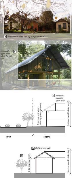
54 On a broader application of DDO1, built form that visually dominates the landscape, or interrupts viewlines, or which is sited above the tree canopy height, are discouraged. A Design objective is to promote building scales compatible with the prevailing one and two storey domestic buildings. The Design guidelines provide more specificity to these objectives, by stating that the maximum wall height of a building should not be more than 6.0 metres. We find that the proposal that is before us for the review site achieves these design outcomes, and others that are sought in DDO1 for the Eltham Gateway. We make this finding for the following reasons:
a. The proposal intends to add a series of two and three storey buildings to the existing one and two storey buildings on the review site. The tallest of the proposed built forms have wall heights of up to 8.13 metres for the southern elevation of Dwelling 18, 7.95
metres for the southern elevation of Dwelling 16, and 7.32 metres for the eastern elevation of Dwelling 5. The southern elevations of Dwellings 16 & 18 are setback between 20 and 26 metres from the southern boundary of the review site. While closer oblique views can be gained from the adjoining property to the east of the review site, the buildings will still be two storeys in scale, which is consistent with the surrounding scale of buildings. Further, we are not persuaded that views from surrounding private properties to built form is the focus or intent of DDO1. Rather, this control seeks to influence public views on the approach to Eltham.
b. While the steeply pitched roofs add to the height of the proposed buildings, this form of roofing is consistent with the style of development already found in the Eltham Gateway, including the existing house at 715 Main Road and the studio on the review site, both of which are heritage listed. As a consequence, we find that this proposed roof form contributes to the unique architectural character found and valued in Eltham.
c. The upper levels of the buildings are generally not visible from the public domain, except for the apartments which are incorporated into the retained buildings at the front of the review site. In the case of Lillies House, the upper storey is entirely contained within the existing roof form, while for the ‘lofts’ the upper level is contained within the existing roof form but with individual dormer windows that are recessed from both the eaves and ridgeline. In our view, this achieves a recessed upper level where it is most required. The garden houses and tree houses are further into the site where the fall of the land sets them at a lower level, and as a result we find the scale is acceptable without the need for upper level recession. The two lake houses are almost A frame in proportion so that the upper levels are effectively recessed from the wall line.
d. We also note that the building style and roof forms of the proposal closely reflect the guidance we were referred to from the Eltham Gateway Design Guidelines (Hansen Partnership, March 2013). This document illustrates pitched roof forms and materials featuring timbers, earthy colours and glazing, and even features the existing buildings in the frontage of the review site (The Loft House and Lillies) as relevant examples. We note that it encourages contemporary interpretations rather than reproductions of the Eltham style houses. Where it refers to upper level setbacks, this is discussed in terms of the ability to plant shade trees and to minimise overlooking and overshadowing. We have found the overall setbacks provided are sufficient to allow for tree planting and for reasons set out later in this decision, we have found no issues with overlooking or overshadowing. We conclude that the
proposed buildings are substantially in accordance with the guidelines.

The attached building forms will combine to produce buildings of some length. However, they will be highly articulated, and well ack from the surrounding streets, from which they will have a very low level of visibility. We also note that Mixed Use Zone, there are a number of buildings of substantial length, which have much greater visibility in the streetscape, a compared to the buildings now proposed for the review site. We also consider that the attached form of housing is an appropriate response to the strong encouragement from both planning policy for medium density housing on the ew site, while responding to the constraints provided by a desire for less built form in the streetscape, as well as the heritage and flooding constraints that apply to different parts of the review site. For these reasons we find that the proposed attached form of housing is an appropriate response to the opportunities and constraints offered by the review site.
f. The garden houses are set behind the Lofts and are aligned along the driveway thus providing some visibility from Brougham Street. This is dealt with by setting the southern half of the garden houses
at a lower level. With the lofts being closest to the street, the effect will be the developments further into the site, to the limited extent they are visible, will be seen to be stepping down the site and following the contours. This is evident in the architect’s render, as shown below:

g. The buildings are proposed to be constructed from timber, steel vertical corrugated sheet and metal balustrades, adopting natural timber colours and greys and blues for the corrugated sheeting. We find this will achieve the earth and timber tones sought by DDO1 and as noted before, to the extent that it differs from the existing light tones of No 715 Main Street, we find this to be an advantage to ensure the new development is clearly distinguished from the heritage context.
h. The review site is currently served by two separate crossovers from Brougham Street. The proposed development intends to remove one of the existing crossovers, and replace it with additional landscaping. We consider that this represents a positive aspect of the proposed development, consistent with the following guidance from DDO1.
The number of driveway crossovers should be limited to 1 on standard lots and rationalised on larger or consolidated lots.
i. The proposal will achieve an increase in the canopy coverage on the review site. The proposal proposes the removal of eight trees, two of which are environmental weeds. In contrast, the proposal intends to plant 72 canopy trees of 10 metres in height or taller at maturity. This represents a very positive outcome, in light of the objectives for the Eltham Gateway precinct.
55 For these reasons we find that the proposed development is an appropriate response to the surrounding neighbourhood character, and the guidance provided by the Nillumbik Planning Scheme.
Landscape/ecology assessment
56 Schedule 1 to the Environmental Significance Overlay (ESO1) applies to sites of faunal and habitat significance. The Schedule to ESO1 provides the following guidance.
Statement of environmental significance
Much of the Shire is heavily vegetated and supports a diverse range of native fauna and flora. Some species are listed under the Flora and Fauna Guarantee Act. There are specific sites occurring on both private and public land that have been identified as being of particular importance within the Sites of Faunal and Habitat Significance in North East Melbourne (Beardsell 1997). Identification, protection and enhancement of the environmentally significant sites and strengthening of connecting habitat links will assist in the maintenance of biodiversity within the Shire and surrounding areas.
Environmental objective to be achieved
To protect and enhance regional and strategic habit links, including sites of faunal and habitat significance identified in (Beardsell 1997) Sites of Faunal and Habitat Significance in North East Melbourne.
57 During the course of the planning permit application, the applicant commissioned an ecology report,5 which made the following findings.
The design of the Co-housing development has been revised, in consultation with Nillumbik Shire Council, since its initial conception. The revised plans have removed any impacts to native vegetation and aim to reduce the impact on significant vegetation, by specifically:
• Retaining and enhancing all existing vegetation where possible through careful positioning of buildings and parking areas.
• Following the Eltham Gateway Design Guidelines 2013 by reducing any impacts upon trees defined as substantial and vegetation characteristic of the Eltham Gateway.
• Retaining habitat connectivity with the adjacent Diamond Creek and Wingrove Park vegetation via the careful positioning of
5 Ecological Assessment for a proposed cohousing community at 62A Brougham Street, Eltham, Victoria (Ecology & Heritage Partners, October 2022).
buildings and parking areas toward the front of the property within the areas of existing infrastructure and high disturbance.
• Avoiding impacts to substantial trees considered to be characteristic of the Eltham Gateway and minimising the removal of canopy layer species.
• Reducing the number of dwellings from 26 to 21.
• Lowering the car parking rate via the reduction of car parking spaces from 34 to 29.
• Indigenous planting and revegetation of the Riparian Woodland in the sites southern area.
• Indigenous planting under the existing Ironbark trees.
TreeLogic have deemed that Tree ID 2 will not be impacted (directly or TPZ encroachment) as the following is proposed:
• Existing path north-west of tree remain unchanged.
• TPZ appropriately protected during all stages of construction (see section 5.2)
Additionally, the area south of the south-western most building (Figure 2) which encroaches upon tree ID 2’s TPZ is proposed to entirely comprise raised decking.
The south-western patch of native Riparian Woodland vegetation (Figure 2) contains an existing path underneath the shrub/small tree canopy and is proposed for retention as no path modification is proposed.
In the context of the development, the modified condition of ecological values proposed to be impacted, and the extent of native vegetation, substantial trees and vegetation characteristic of Eltham Gateway proposed to be retained within the study area, it is considered that the minimisation measures implemented are appropriate in this instance.6
58 A subsequent memo dated 21 March 2023 was also prepared by the same authors as the original Ecology report, which set out the following.
As detailed in the above table and supported by the arboricultural report produced by Tree Logic, the origin of the vegetation proposed to be impacted is predominately introduced/exotic and/or nonVictorian Native. The remaining Red Ironbark and Giant Honeymyrtle specimens are considered native plantings due to the negligible likelihood of these specimens being present as a result of self-seeding due to the absence of a seed source and the historical usage of the study area as a production nursery. It is our opinion that the current proposal does not destroy, lop or remove any remnant native vegetation as defined under the Nillumbik Planning Scheme.
6 Page 22, Ecological Assessment for a proposed cohousing community at 62A Brougham Street, Eltham, Victoria (Ecology & Heritage Partners, October 2022).
59 The Council made no submissions opposing the ecological or habitat impacts of the proposal. Ms Bullen submits that the proposed development will disrupt the movement opportunities for habitat in this location. We are not persuaded by this submission, for the following reasons. As we explore in greater detail below, the application proposes the removal of eight trees from the review site, and the replanting of 72 canopy trees7 of 10 metres in height or taller at maturity, as well as many smaller trees. Over the long term, this proposal will therefore provide an increase in habitat opportunities for various forms of fauna. While we appreciate that the proposal will introduce buildings into existing open space areas, fauna have already shown the ability in this location to adapt to the placement of new buildings. That is evident in the construction of the Eltham Fire Station on the opposite side of Brougham Street in 2014/15, and a sizeable extension to the Eltham Leisure Centre in 2016-2018. Both of these developments comprised buildings much larger than that proposed for the review site, and yet neither have caused the local fauna to stop their habitat movements through this corridor. We anticipate the same outcome in respect of the proposed development on the review site.
60 As such, we are persuaded by the contents of the ecological assessments undertaken to date, that the proposal is an appropriate response to the Environmental Significance Overlay.
61 Finally, the review site is also located in Schedule 7 to the Significant Landscape Overlay (SLO7). The Schedule to SLO7 provides the following guidance.
Statement of nature and key elements of landscape
The Eltham Gateway is recognised as an important natural and historic part of Eltham and provides a strong sense of arrival into the township. Its topography and vegetation are fundamental elements of its character, providing leafy views across the Diamond Valley. A strong indigenous tree canopy across the Gateway is achieved via extensive tracts of public land coupled with low density housing developments with large gardens that are often continuous with road vegetation, particularly in the south. To the north, development is generally clearly visible from the street but remains integrated with its bushy setting primarily by remaining below the dominant tree canopy and providing generous setbacks and landscaping.
Landscape character objectives to be achieved
To recognise, protect and enhance the contribution provided by indigenous and native vegetation, to the character and amenity of the Eltham Gateway.
7 That is, within the review site inside the Mixed Use Zone, with a further 56 canopy trees of 10 metres or more in height proposed on the adjacent land within the Urban Floodway Zone.
To ensure that the health of existing vegetation, particularly that which contributes to the character of the Eltham Gateway, is not jeopardised by new development.
To retain and enhance the bush vegetation dominated vistas and streetscapes.
To ensure that adequate landscape zones are provided in all developments to allow retention and planting of canopy trees in a bush garden setting.
To discourage formal gardens with exotic plantings that do not blend with roadside vegetation.
62 The application proposes the removal of eight trees from the review site. According to the Council’s submission, the removal of five of these trees require a planning permit under the SLO7 provisions. The Council does not oppose any of the proposed tree removal on the review site.
63 The eight trees that are proposed to be removed are as follows:
a. Tree 6 is a small tree that is described in the following manner in Ms May’s evidence. Given this description, we support its removal.
Tree 6 is part of a group of young Lemon-scented Gum located near the north-west corner of the site. Its removal is proposed to accommodate a car parking space. This tree is the smallest of the trees in this group, having a diameter at breast height (DBH) of just 13cm. It is suppressed with poor structure and is unlikely to develop well. It has a low arboricultural value. Given this and that it forms a group rather than an isolated tree, its removal is likely to have little if any impact on the amenity that this group of trees provides to the area.
b. Tree 15 has a pronounced lean, as depicted in the photograph below, extracted from Ms May’s evidence. Due to the form of this tree, we support its removal.

c. Trees 16 & 17 are exotic trees, of fair to poor structure, which are best removed and replaced with an indigenous canopy as encouraged by the Nillumbik Planning Scheme.
d. The removal of Trees 21 & 51 are supported by Council’s arborist, as they are of low to moderate value. We are persuaded by the evidence of Ms May that they are suitable to be removed given their low level of contribution to the surrounding landscape.
e. Trees 45 & 47 are both species of weed, listed on the Nillumbik Shire Council Environmental Weeds List 2009. Their removal is therefore supported.
64 Further, it is the evidence of Ms May that the proposal is unlikely to impact any of the neighbouring trees. We note this detailed evidence at pages 8 and 9 of Ms May’s evidence, and that Ms May has conducted exploratory root trenching to demonstrate no impact on one of the neighbouring trees. We are persuaded by and adopt Ms May’s evidence that the proposal will not have a detrimental impact on any of the neighbouring trees.
65 Balanced against the proposed tree removal is the proposal to undertake extensive landscaping across the review site, which will include the planting of 72 canopy trees of 10 metres in height or taller at maturity, as well as many smaller trees. In addition, the applicant will also have the opportunity to undertake further planting in the Urban Floodway Zone, separate from this planning permit application. This is a substantial amount of new indigenous landscaping to be inserted into this part of Eltham, and represents a significant boost to the treed character and quality of the review site and surrounding neighbourhood.
66 For these reasons we find that the proposal is an appropriate response to the landscape and ecological values of the review site and the surrounding context.
DOES THE PROPOSAL APPROPRIATELY RESPOND TO THE FLOODING CONSTRAINTS ON THE LAND?
67 During the course of the planning permit application, a Flood Impact Assessment Report8 was prepared and lodged with Council. This report provides the following information.
The southernmost parts of the site have been identified to be at risk of flooding from Diamond Creek during a rare (1% AEP) flood event and are covered by an Urban Floodway Zone (UFZ) and a Land Subject to Inundation (LSIO) overlay as shown in Figure 1-1 below.
As the site is located in the UFZ and as no Local Floodplain Development Plan for the area has been incorporated into the planning scheme, a flood risk report (herein) was prepared in 2022 to support the developments planning permit application (Water Technology, 2022).
This work is undertaken to address Melbourne Water’s requirement of a flood modelling assessment being required to assess the proposed impacts of the development fill works on floodplain requirements. A 2-Dimensional flood modelling of the riverine catchment for the Subject Property was undertaken for the critical 1% AEP flood event.9
…
Following the results of this investigation, the following conclusions can be made for the proposed development:
8 Report, 62A Brougham Street, Eltham – Flood Impact Assessment (Water Technology, 26 May 2023).
9 Page 3 of Report, 62A Brougham Street, Eltham – Flood Impact Assessment (Water Technology, 26 May 2023).
• The 1% AEP overland flow is maintained in both scenarios, with no increase in flood levels on adjoining properties; there is no loss of conveyance.
• There is no significant loss of flood storage;
• Site safety criteria (including site access) is met in the proposed conditions;
• Floor Levels (FFL) of the 12 southern dwellings (lots 9 to 20) fronting the floodplain will all achieve the minimum flood freeboard requirement (even relative to Melbourne Water’s applicable flood levels); and
• The proposed development can comply with the requirement to preserve the existing environmental values in the floodplain.
Based on the above, Water Technology considers that the proposed development will not have any adverse impacts on flooding and the development can be designed to ensure the safety of its users, visitors and any emergency service personnel.
68 The Council raises no concerns in relation to the response of the proposal to the flooding constraints on the review site.
69 The Eltham Community Action Group questions the wisdom of constructing dwellings close to flood prone land, without actually putting any information before the Tribunal that would argue that the proposed dwellings might be flood affected in the future.
70 It is evident that the flooding constraints that apply to the review site have been one of the driving factors behind the layout and overall design that is now before us. As a result, all dwellings, accessways, carparking areas and areas of private open space are located outside of the Urban Floodway Zone.
71 The application was referred to Melbourne Water, as the floodplain management authority, who has consented to the grant of a planning permit for the proposed development.
72 For these reasons we are persuaded that the proposal has appropriately responded to the flooding constraints that apply to the review site. While parts of the broader site are subject to flooding, the review site also comprises over an acre of land outside of the Urban Floodway Zone, and in a Mixed Use Zone where more intense forms of housing development are encouraged. Where it can be achieved, an outcome that increases housing opportunities while responding appropriately to the flooding constraints, is an outcome that is encouraged by the Nillumbik Planning Scheme. For these reasons we do not find the potential for broader parts of the site to flood, to be a constraint on the level of development now proposed for the review site.
WILL THERE BE ANY UNREASONABLE OFF-SITE AMENITY IMPACTS?
73 The Council raises concerns in relation to the potential visual bulk impacts to the adjoining property to the west, as a result of the scale of the proposed Dwelling 19. They raise no other concerns relating to off-site amenity impacts.
74 The Eltham Community Action Group submit that the 1700mm high screen to the balcony of Dwelling 18 will be insufficient to limit overlooking, and that conversations from this balcony will be heard from the adjoining residential property. They submit that this, “is not acceptable on properties in the Eltham Gateway.”
75 Ms Bullen submits that the proximity of the deck at Dwelling 18 to her property, will mean that conversations can be heard over the boundary. In response to this concern, we do not regard residential noises within a residential area as representing an unreasonable amenity impact. Indeed, some might even regard such interaction with neighbours as part of living in a community. In any case, the Nillumbik Planning Scheme does not require setbacks to be provided such as to avoid one residential neighbour from hearing another neighbour. For these reasons, we are not persuaded that the potential that Ms Bullen might hear conversations from the deck to the proposed Dwelling 18, as an unreasonable amenity impact.
76 On a visual bulk assessment, the proposed Dwelling 19 complies with Standard B17. As a result of the deemed to comply provisions at Clause 55 of the Nillumbik Planning Scheme, we therefore must also find that the related objective is achieved, which is:
To ensure that the height and setback of a building from a boundary respects the existing or preferred neighbourhood character and limits the impact on the amenity of existing dwellings or small second dwellings.
77 We therefore must find that the height and setback of Dwelling 19 respects the surrounding neighbourhood character, and appropriately limits the impact on the amenity of the adjacent residential property. Further, given the relatively small length of the relevant elevations, and the high level of articulation provided by the steeply pitched gable roof form, we also find that there are no other elements of the design of Dwelling 19, that would cause unreasonable visual bulk impacts on the adjoining residential property.
78 The remainder of the proposed dwellings on the review site have a direct interface with three adjoining properties. We are informed that the properties at 64 and 66 Brougham Street are used as an office and a medical centre respectively. As such, the proposal could not cause an amenity impact to these non-residential uses in the Mixed Use Zone, either by way of visual bulk, overshadowing or overlooking.
79 The remaining sole residential interface that is adjacent to the proposed buildings on the review site is presented by the land at 715 Main Road. The proposal will interact with this adjoining property with the siting of a two storey building setback some 4.5 metres from the common boundary, and have wall heights of between 6.99 and 8.16 metres. A deck at the front and side of that proposed building will be setback 1.75 metres from the common boundary.
80 An important starting point in a visual bulk assessment is whether the proposed wall height and setback complies with Standard B17. At a maximum wall height of 8.16 metres, the proposal is required under Standard B17 to be setback 3.26 metres. The proposed 4.5 metre setback comfortably exceeds this requirement. Due to the deemed to comply provisions now found at Clause 55 of the Nillumbik Planning Scheme, if Standard B17 is met, then the related Side and rear setback objective is deemed to have been met, which was set out earlier in these reasons.
81 As a result, we must find that the proposed height and setback of the proposed Dwelling 18, will achieve appropriate amenity outcomes on the adjoining residential property. Further, given the length of the wall is relatively modest at just 12.04 metres, we cannot consider the length of the wall to contribute to an unreasonable extent of building bulk, especially when considering the generous setback of 4.5 metres. We also note that Dwelling 18 has been provided with a lower pitched roof form, that produces less visual bulk for this abutting property. We therefore cannot find that the roof form results in an unreasonable extent of visual bulk.
82 For these reasons we find that the proposed development will not result in any unreasonable levels of visual bulk on the adjoining residential properties.
83 The proposed shadow diagrams demonstrate that only a very minor level of additional shadowing will be caused to the one adjoining residential property to the east of the review site at 3:00pm at the equinox. This means that a very large area of secluded private open space on the adjoining property will remain free from shadow. As a result, Standard B21 and the related objective is achieved.
84 Finally, the proposal will not result in any unreasonable level of overlooking to the adjoining residential property to the east of the review site. The elevations indicate that obscured glazing will be applied to the two first floor windows to the proposed Dwelling 18, as well as one of the windows proposed at ground floor level. This is an acceptable technique for reducing overlooking. The remaining ground floor window, as well as the deck, will have overlooking limited by 1700mm screening. The height of this screening is in accordance with Standard B22, which again means that the related objective is deemed to have been complied with.
85 The Eltham Community Action Group argues for screens taller than 1700mm to restrict overlooking. However, the Nillumbik Planning Scheme
does not support such a request. As we must be guided by the content of the Nillumbik Planning Scheme, we will support the overlooking measures that are already depicted on the plans that are before us.
86 For these reasons we find that the proposed development will not result in any unreasonable off-site amenity impacts.
IS AN APPROPRIATE LEVEL OF INTERNAL AMENITY PROVIDED?
87 The Council submits that the lack of private open space within the proposed development, and the provision of low permeable fencing around the private open space areas, will not contribute to an appropriate level of internal amenity. The Council holds this view, while acknowledging the extent of communal open space that is proposed throughout the review site. The Council also submits that some of the proposed dwellings will have a poor sense of address.
88 The Eltham Community Action Group submit that Dwellings 9-18 inclusive have a reduced access to natural light, narrow internal living areas and small areas of private open space. This they argue will impact the amenity of future residents of these dwellings. They also raise a concern with the size of the storage spaces proposed throughout the development.
89 We are not persuaded by these submissions, and instead find that the proposal provides an appropriate level of internal amenity for future residents. We make this finding for the following reasons.
90 In relation to the provision of open space, while some of the proposed dwellings have a limited area of private open space, all residents will have access to very generous areas of communal open space, which is described in the following manner in the evidence of Mr Iles.
• A large (791m2) communal open space area.
• A communal recreation building.
• Communal storage areas/buildings.
• Communal productive gardens.
• Communal outdoor dining facilities.
91 In addition, the future residents on the review site will also have access to the 1923 square metres of open space that exists on the part of the broader site that is covered by the Urban Floodway Zone.
92 We find that the provision of private open space on the review site is appropriate. We make this finding for the following reasons. While six of the proposed 21 dwellings will have less than 40 square metres of private open space, we consider that the areas that are provided for these six dwellings are functional, appropriately dimensioned, and importantly will enjoy high levels of solar access. To the extent that these areas fail to meet Standard B28, we consider that this is more than addressed by the substantial provision of communal open space on the review site. Indeed,
we consider that the standard and variety of communal facilities to be provided on the review site, will provide a higher standard of internal amenity for future residents, than if each dwelling were provided with the area required under Standard B28.
93 We note that many of the areas of secluded private open space are provided at ground level surrounded by low open style fencing. As a result, views can easily be gained into these areas of private open space. While that reduces the available privacy, it also enhances the sense of community and the interactions that can occur between neighbours. We observe that the positive aspect related to the enhanced interactions, might balance the negative associated with reduced privacy. Others might feel that the positive outweighs the negative. Given the impact on privacy exists as a result of viewing between areas of communal open space and private open space, as opposed to direct views from the public realm, we consider that the lack of privacy to the areas of private open space does not ‘tip the scales’ and make the areas of private open space unacceptable. We form this view having regard to the wide range of communal open space options available on the review site, and the fact that many of the proposed dwellings are provided with a secondary area of private open space in the form of a first floor balcony.
94 In relation to the sense of address to be enjoyed by some of the dwellings, we accept that this proposal has an unusual layout where the proposed dwellings are sited in an unconventional manner throughout the site. This is in response to the site constraints, namely the extent of land that is liable to flooding, and the location of the heritage assets. The result is a need to traverse paths that weave across the site to access some of the dwellings. To the extent that this might mean some dwellings are not conveniently located and visible from the street, it also means that the proposed buildings are intertwined with areas of open space that provides a positive balance between built form and landscaping areas. In these circumstances, we consider that the proposal is appropriate, and well located signage can provide a reasonable sense of address for all dwellings.
95 In relation to the concerns raised by the Eltham Community Action Group, we find that the proposed dwellings will provide an appropriate level of internal amenity. The internal living areas for Dwellings 9 to 18 inclusive will have a width of 4.20 metres to the living and dining areas, and 3.2 metres to the kitchen areas. Given that these areas have a combined length of some 11.6 metres, we consider that they are of reasonable dimensions to provide for an appropriate level of internal amenity. Further, the ability for these open plan living areas to have a dual aspect to both the north and south, will mean that they are provided with an acceptable level of internal daylight.
96 Finally, in relation to the storage areas, we note the following evidence of Mr Iles, extracted from his written evidence statement.
In response to Standard B30, 21 dwellings are proposed which requires the provision of 126m3 of storage area. Across four storage areas, 153.5m3 of storage area is provided. This is within the Communal Storage building (47.04m3), Communal Recreation building (42.74m3), the Communal Storage shed (15.36m3), and Communal Storage within the lower Ground Floor (16.12m3). The proposed storage areas are conveniently accessible and secure, being available to all proposed dwellings. Future management will be coordinated by Owners Corporation, noting that the shared use of these facilities (in lieu of private cages) is in alignment with the cohousing ethos.
97 While the communal approach to storage areas is unusual, we are persuaded by the evidence of Mr Iles that the review site as a whole will be able to accommodate the reasonable storage needs of the future residents.
98 For these reasons we find that the proposal provides an acceptable level of internal amenity for future residents.
DOES THE PROPOSAL APPROPRIATELY PROVIDE FOR CAR PARKING AND TRAFFIC MOVEMENTS?
99 The Council submits that the manner of car parking provision on the review site, and the distance between some dwellings and their allocated car parking spaces, do not provide an appropriate level of convenience for future residents.
100 The Eltham Community Action Group also oppose the use of the existing car parking area in the front of the review site, arguing that it will lead to an inappropriate visual outcome. They further submit that this development, along with others, will encourage Council to widen the narrow single lane bridge along Brougham Street, which would be to the detriment of the character of the area. They also oppose the non-provision of visitor car parking on the review site, given the distance to the railway station and the absence of available on-street car parking
101 Ms Bullen also raises traffic related concerns, based on the single lane bridge in Brougham Street. She is also concerned regarding the potential to evacuate in the case of a flood or fire.
102 The application proposes the provision of 29 car parking spaces on the review site, which is in accordance with the amount required for residents under Clause 52.06 of the Nillumbik Planning Scheme. No visitor car parking is required to be provided on the review site under Clause 52.06. As such, a planning permit is not required for a reduction of car parking. To the extent that visitors may be present on site from time to time, we anticipate that they will either park in a vacant resident car space on site, or park at the Eltham Leisure Centre, and walk the short distance to the review site.
103 Aside from the single car garages for Dwellings 6, 7 & 8, car parking for residents are provided in open car parking areas, both at the front of the review site, and along part of the eastern boundary. This is not consistent with Clause 52.06-9, which requires one car space to be under cover, where two or more car parking spaces are provided for a dwelling. In the context of the proposed development for the review site, we support the provision of open at grade car parking for 18 of the proposed 21 dwellings, as a means of responding to the site constraints posed by the Urban Floodway Zone and the Heritage Overlay, and in recognition of the cohousing model that is sought to be implemented on the review site. While some of the future residents will need to walk across the review site to access their parked vehicle, we do not consider this to be unreasonable under these circumstances, with the applicable site constraints. While this results in a lower level of amenity for some of the future residents, we consider that this needs to be balanced against the high level of amenity provided by the wide range of communal facilities to be provided on the review site, as previously identified. It also needs to be balanced against the positive landscape outcomes that result from a reduced extent of built form, that flows from the absence of garages or carports for 18 of the proposed dwellings.
104 Further, while the provision of a car park in the front of the review site is unusual, in this case the siting and layout of the car park already exists in this location. As such, the proposal intends to make little visual change to the existing site conditions, other than to remove one of the existing vehicle crossovers to Brougham Street, and increase the extent of canopy tree coverage in the front setback. We cannot support a submission that these changes would result in an inappropriate visual outcome.
105 We now turn our attention to the concern raised by the respondents, concerning increased traffic from the review site and its impact on the single lane bridge in Brougham Street. The application comprises 21 dwellings, and according to the traffic analysis circulated with the amended plans, will result in 117 daily trips to Brougham Street, including 12 trips in the peak hour. These figures were not disputed by any party. These trips are anticipated to be spread between vehicles travelling east and west along Brougham Street, so only a proportion of these 117 trips, or 12 trips in a peak hour, will occur to the west and across the single lane bridge.
106 Given that the Eltham Major Activity Centre and Eltham Railway Station are both accessed by travelling east along Brougham Street, it is considered that at worst, half of the anticipated traffic volumes will travel west along Brougham Street and cross the single lane bridge. This results in 6 vehicles in the peak hour, or one every ten minutes. We do not anticipate that this low level of traffic would result in unreasonable congestion along Brougham Street, even accounting for the single lane bridge that is found to the west of the review site.
107 Further, this traffic needs to be compared to the historical traffic generation from the review site. The land previously operated as a café and shop, with car parking for at least 24 cars at the front and rear of the review site visible on historical aerial photography. This would have generated a certain level of traffic along Brougham Street. The proposed 117 vehicle trips associated with the development of the review site, are therefore not all additional trips when compared to the historical use of the land. As such, the additional traffic will actually be considerably less than the 6 additional vehicles in a peak hour that is anticipated to utilise the single lane bridge in Brougham Street.
108 For these reasons, we find that the proposal will not result in an unreasonable increase in traffic along the surrounding road network.
109 The final concern raised by Ms Bullen relates to evacuation of the review site in the case of a flood or fire. In the case of a flood, there will be no need to evacuate the review site, as all of the proposed dwellings are sited above the 1 in 100 year flood level. However even if such an evacuation were to occur, Brougham Street east of the review site provides a flood free evacuation route.
110 The designation of the review site as a bushfire prone area, and the implications of this designation, are addressed separately below.
111 For these reasons we find that the proposal appropriately provides for car parking and traffic movements.
ARE THERE ANY OTHER ISSUES?
112 The review site is within a designated bushfire prone area. During the course of the planning permit application, the applicant submitted a Bushfire assessment,10 which sets out the following conclusion.
The landscape is one of low bushfire risk. Bushfire behaviour can reasonably be expected to be within AS 3959-2018 presumptions and design parameters. Accordingly, it is considered that the risk can be mitigated to an acceptable level and that the proposed development is appropriate, if dwellings are separated from hazardous vegetation sufficiently for the stipulated BAL construction standards, in accordance with the building regulations and Clause 13.02-1S.
The type and extent of (hazardous) vegetation within, and up to 100m around, the property has been identified and classified into AS 39592018 vegetation groups, based on the Ecological Assessment plan (EHP, 2022), DEECA extant EVC mapping, aerial imagery and site assessment. The classification is based on the current and likely future state of the vegetation and identifies that the hazard is Grassland and Woodland, confined almost wholly to the south and west of the assessment zone.
10 Bushfire Development Report (Terramatrix, February 2023).
Overall, the topography on and around the site, within the 100m assessment zone and extending to 400m, is moderately undulating, with no significant changes in elevation beneath classified vegetation that would significantly exacerbate the bushfire attack. For the purposes of determining BALs and commensurate setbacks from classified vegetation, the applicable slope class is 'All slopes and flat land' under the Woodland to the south.
It is considered that development can appropriately prioritise the protection of human life and meet the objectives of Clause 13.02-1S, largely by ensuring future dwellings will be sited and constructed to a BAL under the Building Regulations.
Good access and egress for emergency management vehicles and residents, in the event of a bushfire, can be achieved via the proposed internal road network and driveways.11
113 The Council does not raise any concerns in relation to the response to the site’s designation as a bushfire prone area. Ms Bullen raises a concern as to the ability to evacuate the site in a bushfire.
114 The review site has direct access to a sealed road in Brougham Street, and the entrance/exit to the review site is within 100 metres of a declared main road in Main Road. As such, the review site enjoys a high level of access to a well maintained access route, over and above that which would commonly be available to sites within a designated bushfire prone area.
115 Ms Bullen raises particular concerns regarding the impact of the single lane bridge in Brougham Street to the ability to evacuate the review site. This single lane bridge is not a blockage to all access, however we accept that it may add delays to travel times. If that is the case during a bushfire, then Main Road provides for egress to both the north and south, and also connects with numerous other roads to provide further egress options. Again, we consider that the range of travel options along various roads that are available in close proximity to the review site, far exceeds that which would commonly be available to land within a designated bushfire prone area. In other words, this is not a location with a limited range of travel options in the event of a bushfire.
116 In terms of access for emergency vehicles during a bushfire, while we note that in a large scale bushfire emergency vehicles will not always attend from the closest fire brigade, we note that the Eltham City Fire Station is located directly across the road from the review site. As such, emergency firefighting vehicles from this Station, will not need to travel across the single lane bridge in Brougham Street to access the review site.
117 Given the low bushfire risk that is presented to the review site, we consider that more than adequate access is available to the review site.
11 Page 33, Bushfire Development Report (Terramatrix, February 2023).
WHAT CONDITIONS ARE APPROPRIATE?
118 A number of other matters about permit conditions were raised by the parties. With respect to those matters, consent was reached between the applicant and the Council regarding the final form of permit conditions, in the event that we determine to direct the grant of a planning permit.
119 The applicant has requested an expiry date of four years to commence, and six years to complete the development, which was not opposed by any party. We consider that an expiry date that allows three years to commence and five years to complete is more reasonable, while allowing an appropriate time for the development to be commenced and completed. We also note that of course there is the ability for the land owner to seek an extension of time, should these timeframes prove to be unachievable.
120 The Eltham Community Action Group Inc requested a small range of additional conditions, which were addressed orally at the time they were raised by this party.
CONCLUSION
121 For the reasons given above, the decision of the responsible authority is set aside. A permit is granted subject to conditions.
Micheal Deidun Stephen Axford Member Member
APPENDIX A – PERMIT CONDITIONS
PERMIT APPLICATION NO
907/2022/03P
LAND 62A Brougham Street Eltham
WHAT THE PERMIT ALLOWS
In accordance with the endorsed plans:
• To construct two or more dwellings on a lot
• To construct a building and construct or carry out works
• To construct a fence
• To remove vegetation
• To partly demolish a building
CONDITIONS
1 Before the development commences, amended plans to the satisfaction of the Responsible Authority must be submitted to and approved by the Responsible Authority. When approved, the plans will be endorsed and will then form part of this permit. The plans must be generally in accordance with the plans by DKO Architects, Project number 00012940, Drawing numbers TP001-4, 100-102, 200-207, 300-307, 309-310, and 500-502, all marked revision 04 and all dated 16 February 2024, but modified to show:
(a) All plans to clearly show the UFZ land excluded from the site.
(b) Notations on all plans in accordance with conditions 5 and 6 of this permit.
(c) Plan TP004 amended to allocate car spaces in accordance with Clause 52.06-5 of the Nillumbik Planning Scheme
(d) Changes to the plans in accordance with Drawing numbers 201, 205, 206, 302a and 306 all marked Revision 05, and all dated 19 March 2024 (attached to the expert evidence of Kylie May).
(e) The driveway ramp grades in compliance with Clause 52.06-9 (Car Parking).
(f) An amended landscape plan in accordance with Condition 3 of this permit.
(g) A Tree Protection Management Plan in accordance with condition 8 of this permit and consequential changes to the design plans.
(h) The heritage studio and shed clearly labelled as such.
(i) A Conservation Program to ensure the ongoing preservation for the heritage studio and shed in accordance with condition 17 of this permit.
(j) The location of interpretive signage for the heritage studio and shed in accordance with condition 18 of this permit.
(k) An amended Waste Management Plan in accordance with condition 19 of this permit.
(l) Any changes in accordance with the approved Lighting Plan under condition 25 herein.
(m) Any changes in accordance with the approved Sustainability Management Plan under condition 26 herein.
(n) A notation that reads: “All of the land at 62A Brougham Street Eltham, affected by the Urban Floodway Zone must not be used or developed as part of planning permit No. 907/2022/03P, unless further planning permission is granted to use or develop this part of the land under the permit.”
(o) A notation that reads: “Access to that part of the land at 62A Brougham Street Eltham, affected by the UFZ, via this gate, is permitted for landscape management and maintenance purposes only.”
2 The development as shown on the endorsed plans must not be altered unless with the prior written consent of the Responsible Authority.
3 Before the development commences, a landscape plan to the satisfaction of the Responsible Authority must be submitted to and approved by the Responsible Authority. When approved, the plan will be endorsed and will then form part of this permit. The plan must be generally in accordance with Realm Studios 62A Brougham St Eltham plans comprising drawing Nos 22420-00-L101, L102, L103, L104 all marked Rev G and L105 marked Rev H, but modified to show:
(a) The Council road reserve, UFZ land and the adjoining land to the south excluded from the site and the landscape design.
(b) Notations on all plans in accordance with conditions 5 and 6 of this permit.
(c) The deletion of reference to the UFZ land having capacity for 13 more canopy trees.
(d) The planting schedule to distinguish between retained and proposed plantings.
(e) A survey of all existing vegetation and natural features;
(f) The area or areas set aside for landscaping;
(g) A schedule of all proposed canopy trees, shrubs/small trees and ground cover. This schedule shall include a mixture of selected from
the Council document ‘Live Local Plant Local’ showing the botanical and common name of each plant, the quantity to be planted, the pot size and spacing;
(h) Paving, retaining walls, fence design details and other landscape works including areas of cut and fill;
(i) Appropriate irrigation systems;
(j) Appropriate maintenance details;
(k) The two finishes marked “PV11’ corrected to read “PV10” and “PV11” respectively;
(l) Surface finishes and levels plan L-102, amended to accord with DKO Architect’s Drawing numbers 201, 205, 206, 302a and 306 all marked Revision 05, and all dated 19 March 2024; and,
(m) Changes in accordance with “Planting Schedule” 22420-00-L105 Rev I, dated 8 April 2024.
4 Unless with the prior written consent of the Responsible Authority, before the occupation of the development, the landscaping works shown on the endorsed plans must be carried out, completed and maintained to the satisfaction of the Responsible Authority.
5 The part of the land at 62A Brougham Street Eltham, affected by the Urban Floodway Zone must not be used or developed as part of this planning permit.
6 Access to that part of the land at 62A Brougham Street Eltham, affected by the Urban Floodway Zone, via the gate as shown on the endorsed plans, is permitted for landscape management and maintenance purposes only.
7 No vegetation on-site (unless specified on the endorsed plans) shall be removed, destroyed, felled, lopped, ringbarked, uprooted or otherwise damaged except with the prior written consent of the Responsible Authority.
8 Prior to development commencing a Tree Protection Management Plan (TPMP) prepared by a suitably qualified arborist must be submitted to and endorsed by the Responsible Authority. The report must outline measures to protect all trees which are to be retained on site and third party trees from development impacts including during construction, including the recommendations set out at paragraph 9.34 of report of Kylie May marked “62A Brougham Street, Eltham, John Patrick Landscape Architects Pty Ltd, office Ref: 24-096”, to the satisfaction of the Responsible Authority.
9 The works allowed by this permit must be conducted in accordance with the requirements of the approved TPMP, to the satisfaction of the Responsible Authority.
10 Prior to development commencing (including any demolition, excavations, tree removal, delivery of building/construction materials and/or temporary
buildings), the trees marked on the endorsed plans as being retained must have a Tree Protection Fence (TPF) or where TPF is impractical due to access requirements, a Ground Protection System (GPS) installed to the satisfaction of the Responsible Authority. The fencing associated with this TPZs must meet the following requirements:
(a) Extent
The tree protection fencing (TPF) or Ground Protection System (GPS) is to be provided to the extent of the TPZ (outside approved works), calculated as being a radius of 12 x Diameter at Breast Height (DBH – measured at 1.4 metres above ground level as defined by the Australian Standard AS 4970.2009)
Fencing may be reduced directly adjacent to the works area only to allow access during construction (i.e. no more than 1 metre away from the works/ construction area)
(b) Fencing
All tree protection fencing required by this permit must be erected in accordance with the approved TPMP.
The TPF must be erected to form a visual and physical barrier and must be a minimum height of 1.5 metres and of chain mesh or similar fence
(c) Signage
Fixed signs are to be provided on all visible sides of the TPF clearly stating “Tree Protection Zone – No Entry”, to the satisfaction of the Responsible Authority.
(d) Provision of Services
Unless with the prior written consent of the Responsible Authority, all services (including water, electricity, gas and telephone) must be installed underground, and located outside of any TPZ, to the satisfaction of the Responsible Authority. Where services cannot be located outside the TPZ they must be either bored beneath the TPZ or installed using hydroexcavation (or similar) under the supervision of an appropriately qualified and experience arborist.
(e) Access to TPZ
Should temporary access be necessary within the Tree Protection Zone during the period of construction, the Responsible Authority must be informed prior to relocating the fence (as it may be necessary to undertake additional root protection measures such as bridging over with timber).
11 Prior to the commencement of the approved works (including any demolition, excavations, tree removal, delivery of building/construction materials and/or temporary buildings), the erected tree protection fences/ ground protection system must be inspected and approved by the Responsible Authority.
Once erected to the required standard, the tree protection fencing/ground protection system shall be maintained in good condition and may only be removed upon completion of all development works, or immediately prior to approved works within the TPZ being undertaken, to the satisfaction of the Responsible Authority.
12 The following actions must not be undertaken in any tree protection zone as identified in this permit (unless permitted as part of this planning permit, including the endorsed TPMP), to the satisfaction of the Responsible Authority:
(a) Materials or equipment stored within the zone;
(b) Servicing and refuelling of equipment and vehicles;
(c) Storage of fuel, oil dumps or chemicals;
(d) Attachment of any device to any tree (including temporary service wires, nails, screws or any other fixing device);
(e) Open cut trenching or excavation works (whether or not for laying of services);
(f) Changes to the soil grade level;
(g) Temporary buildings and works; and
(h) Unauthorised entry by any person, vehicle or machinery.
13 The materials to be used in the construction of the buildings and works hereby permitted shall be of non-reflective type and finished in muted tones, to the satisfaction of the Responsible Authority.
14 Air-conditioning and other plant and equipment installed on the subject buildings shall be so positioned and baffled so that noise disturbance is minimised, to the satisfaction of the Responsible Authority.
15 The development hereby permitted must be managed so that the amenity of the area is not detrimentally affected, through the:
(a) Transport of materials, good or commodities to or from the land
(b) Appearance of any building, works or materials;
(c) Emissions of noise, artificial light, vibration, smell, fumes, smoke, vapour, steam, soot, ash, dust, waste water, waste products, grit or oil;
(d) Presence of vermin.
16 Before the occupation of the development commenced the areas set aside for the parking of vehicles and access lanes as shown on the endorsed plans must be to the satisfaction of the Responsible Authority and be:
(a) Constructed.
(b) Properly formed to such levels that they can be used in accordance with the plans.
(c) Surfaced with the materials identified on the plans to be approved under this permit for the north and eastern car parks
(d) Drained.
(e) Line marked or permanently pegged to indicate each car space and all access lanes.
Car spaces, access lanes and driveways must be kept available for these purposes at all times.
17 Prior to the development commencing, a Conservation Program to ensure the ongoing preservation for the heritage studio and shed to the satisfaction of the Responsible Authority must be submitted to and approved by the Responsible Authority. When approved, the program will be endorsed as evidence of its approval.
18 Within 30 days of completion of the development, interpretive signage for the heritage studio and shed must be erected to include a brief history of the site and a description of the buildings’ heritage significance to the satisfaction of the Responsible Authority.
19 Prior to the development commencing, a Waste Management Plan (WMP) to the satisfaction of the Responsible Authority must be submitted to and approved by the Responsible Authority. When approved, the plan will be endorsed as evidence of its approval. The plan must be generally in accordance with the WMP of Eco Results Report no. 2022-3059-WMP, dated 16. February 2024 and show:
(a) The details and location of bin storage and bin collection points by a private waste contractor.
(b) Access route and method of access for the vehicles collecting waste.
(c) Details and location of bin storage areas for each approved dwelling.
(d) Odour control from bin storage areas.
(e) Hour of collection in accordance with condition 19 of this permit.
20 Unless with the prior written consent of the Responsible Authority, the commercial waste collection must not occur outside the following hours to the satisfaction of the Responsible Authority:
(a) For one collection per week, between 6.30 am – 8 pm Monday to Saturday and between 9 am – 8 pm Sundays and public holidays.
(b) For two or more collections per week, between 7 am – 8 pm Monday to Saturday and between 9 am – 8 pm Sundays and public holidays.
21 Vehicular access and egress to the development site from the roadway must be by way of a vehicle crossing constructed / upgraded to the requirements of the Responsible Authority, to suit the proposed driveway and the vehicles that will use the crossing. The Responsible Authority must approve the location, design and construction of the crossing. Any existing
unused crossing must be removed and the disturbed area reinstated to the satisfaction of the Responsible Authority. All vehicle crossing works are to be carried out with Council supervision under an Infrastructure Works Permit.
The width of the driveway at property boundary must match the width of the vehicle crossing.
The vehicle crossing must comply to “Vehicle Crossing Policy” Version 1.0 January 2013 and to Standard Drawing (NS3000, NS3010, NS3020, NS3021 or NS3030 and NS3031) unless written approval has been granted from Council’s Infrastructure Unit.
Vehicle crossing near other services assets may require permission from the relevant authority.
22 Stormwater from the driveway must be collected using 225mm wide trench-grates across the driveway and/or grating pits positioned within the driveway at a maximum spacing of 15 metres to the satisfaction of the Responsible Authority.
Stormwater must be connected to the on-site detention device to the satisfaction of the Responsible Authority. Overflow of stormwater must be connected to the nominated point of discharge. A minimum pipe diameter of 225mm must be used for all underground drains, within the internal drainage system underneath the driveway.
23 The on-site detention device must be designed by a qualified engineer and plans submitted must be to the Responsible Authority for approval, prior to the commencement of the development (except with the prior written consent of the Responsible Authority).
The engineer that is designing the on-site detention device must obtain tc and tso figures from Council. The permissible site discharge must be restricted to a pre development flow rate for a 20% Average Exceedance Probability (AEP) and detained for a 10% (AEP) event.
24 An on-site detention device must be installed, at no cost to Council, in accordance with the endorsed plans and connected to the Council nominated point of stormwater discharge.
Construction of the on-site detention device must be carried out under Council supervision, in accordance with the approved plans and specifications and under an Infrastructure Works Permit.
25 Before development commences a Lighting Plan must be submitted to and approved to the satisfaction of the Responsible Authority. The Lighting Plan must be generally in accordance with the lighting plan of Elev8 Consulting Services (WE-EF Lighting Pty Ltd) Project No. 7933, Sheets 16 inclusive, all marked Rev 1 and dated 14 December 2022.
26 Before development commences a Sustainability Management Plan (SMP) must be submitted to and approved to the satisfaction of the Responsible
Authority. The SMP must be generally in accordance with the SMP of ECO Results Report No. 2022-3059-SMP dated 13 October 2022
27 This permit as it relates to development (buildings and works) will expire if one of the following circumstances applies:
(a) The development is not started within three (3) years of the issue date of this permit.
(b) The development is not completed within five (5) years of the issue date of this permit.
In accordance with section 69 of the Planning and Environment Act 1987, an application may be submitted to the responsible authority for an extension of the periods referred to in this condition.
Melbourne Water
28 Prior to the endorsement of plans under this permit, amended plans to the satisfaction of Melbourne Water and Council must be submitted to and approved by Melbourne Water and Council. The plans must be generally in accordance with the plans submitted with the application but modified to include:
(a) Unimpeded rear access must be provided to Tree House dwellings 14 to 18 to be in line with rear access provided to Tree House dwellings 9 to 13.
29 The Tree House dwellings (dwellings 9 to 18) and Lake House dwellings (dwellings 19 and 20) must be constructed with finished floor levels set no lower than 28.4 metres to Australian Height Datum (AHD), which is 600mm above the applicable flood level of 27.8 metres to AHD.
30 The boardwalks to dwellings 9 to 20 must be constructed with finished floor levels set no lower than 28.4 metres to Australian Height Datum (AHD), which is 600mm above the applicable flood level of 27.8 metres to AHD.
31 Prior to the commencement of the development, a Flood Risk Management Plan (FRMP) prepared by an accredited risk management professional must be submitted to and approved by Melbourne Water. The FRMP must detail the following:
(a) Site specific flood risks associated with flooding from Melbourne Water’s waterways;
(b) Identify and list organisations associated with flood/weather warnings;
(c) Identify the management of a flood emergency response, eg. Evacuation procedures/clearly defined plan of evacuation including people's roles, details of lockable pedestrian and vehicular gates etc;
(d) Notification and contacts of people to be alerted in the event of a flood;
(e) Ongoing staff training and periodic review of these procedures;
(f) Details of flood warning signage and flood markers etc; and
(g) Ongoing use and periodic review of the FRMP (undertaken by suitably qualified person);
32 All proposed decking, stairs and boardwalks must be constructed with unenclosed foundations, remain open underneath for the life of the structure and steps contain no vertical risers, for the passage of overland flows.
33 The building setbacks shown to site boundaries must not be further reduced without the written approval of Melbourne Water, to ensure adequate open space areas to allow for the passage of overland flood flow.
34 Any new fencing or gates below 27.8 metres AHD must be of an open/permeable style (minimum 50% permeable) to allow for the passage of floodwater.
35 All open space below 27.8 metres AHD must be set at existing natural surface level so as not to obstruct the passage of overland flows (no fill or retaining walls are to be used).
– End of conditions –