RESILIENCE+ ADAPTATION
showcased in this issue: STUDIOS
THESIS EXCERPTS and FIELDWORK
including conversations with: UPROSE, Courtney Knapp, Ron Shiffman, Ira Stern
20212022 The Student Magazine of Pratt Institute’s Graduate Center for Planning and the Environment
10 Years After Superstorm Sandy
by Semire Bayatli & Walker Johnston (UPM)
Reimagining Our Streets: What We Resisted, Adapted, and Reclaimed in Brooklyn
by Semire Bayatli & Walker Johnston (UPM)
Envisioning a Community of Care in The Bronx
by James Tschikov & Kevin Garcia (CRP)
Community Love Over Capitalism
by Mariah Chinchilla (CRP)
Rising Tides, Rising Rent: Connecting Climate Justice to Social Housing in New York by Alex
Miller (SES)
Community-Based Alternatives to Watershed Planning and Development in the Lowcountry by Amron
Lee (CRP)
Reclaim/
Reuse/ Recycle! by Ethan Brown, Mahnoor Fatima, Tara Hopp, Megan Maize, Katherine Pioch, Diego Rivandenra, Alison Weidman, Jeremy Ziegler
Challenges to Fresh Food Availability in Coney Island and Opportunities for Inclusive and Sustainable Land Use through Community Gardening
by Nana Acheampong (CRP)
The Impermanence of the Vodou Religion in the Haitian Diaspora
by Claude Jeffrey Charles-Pierre (HP)
Holistic Wellbeing: Two Case Studies in Affordable Housing
by Browne Sebright (CRP)
Towards a Just Transition for the Industrial Waterfront by James
Tschikov (CRP)
02
44
table of contents [CRP: City and Regional Planning] [HP: Historic Preservation] [SES: Sustainable Environmental Systems] [UPM: Urban Placemaking and Management]
06 16 22 30 36
50 56 66 74
LETTER FROM THE EDITORS
Dear Fellow Students,
The theme for the 2022-2023 edition of MultipliCity is resilience + adaptation, threads which undoubtedly pervade all four programs of the GCPE. We wanted to raise awareness about climate change that affects the whole world and share case studies illustrating the challenges, opportunities, and successes when it comes to climate change adaptation. This edition, which we have prepared during the 10th anniversary of Superstorm Sandy, consists of thesis excerpts and reflections prepared by GCPE students, studio case studies, fieldwork, and resilience and adaptation-centered articles.
Importantly, this publication aims to approach resilience + adaptation with a holistic lens. Each piece included in this year’s issue touches on different facets of resilience + adaptation in our disciplines. Articles contemplate: how are communities creating networks of care and deepening their resilience through affordable housing? How are we as a city and collective continuing to adapt to an ongoing pandemic? How can place-based heritage be preserved as communities evolve and adapt? And, critically, how are we moving beyond climate resilience to imagine transformative futures for frontline communities?
In crafting this edition of MultipliCity we were struck by the ways in which resilience + adaptation are embedded within our work and how these terms continue to evolve. We hope this sampling of material inspires you to reflect on our individual and collective responsibility in striving for a more resilient and just world. We would like to thank the GCPE and faculty especially our Department Chair Eve Baron, UPM Academic Coordinator David Burney, and Professor Emeritus Ron Shiffman for their generous support in this endeavor.
We believe in collective effort, as Ron Shiffman said, “People change, people go, people die; but if you can sustain the effort, the network and the organization will continue to serve their true purpose.” As part of the GCPE family, we believe that we are all part of the same effort and wish you success.

 SEMIRE BAYATLI UPM ’23
WALKER JOHNSTON UPM ’23 JAMES TSCHIKOV CRP ’22
61 St. James Pl. Brooklyn, 1238 www.pratt.edu/gcpe
SEMIRE BAYATLI UPM ’23
WALKER JOHNSTON UPM ’23 JAMES TSCHIKOV CRP ’22
61 St. James Pl. Brooklyn, 1238 www.pratt.edu/gcpe
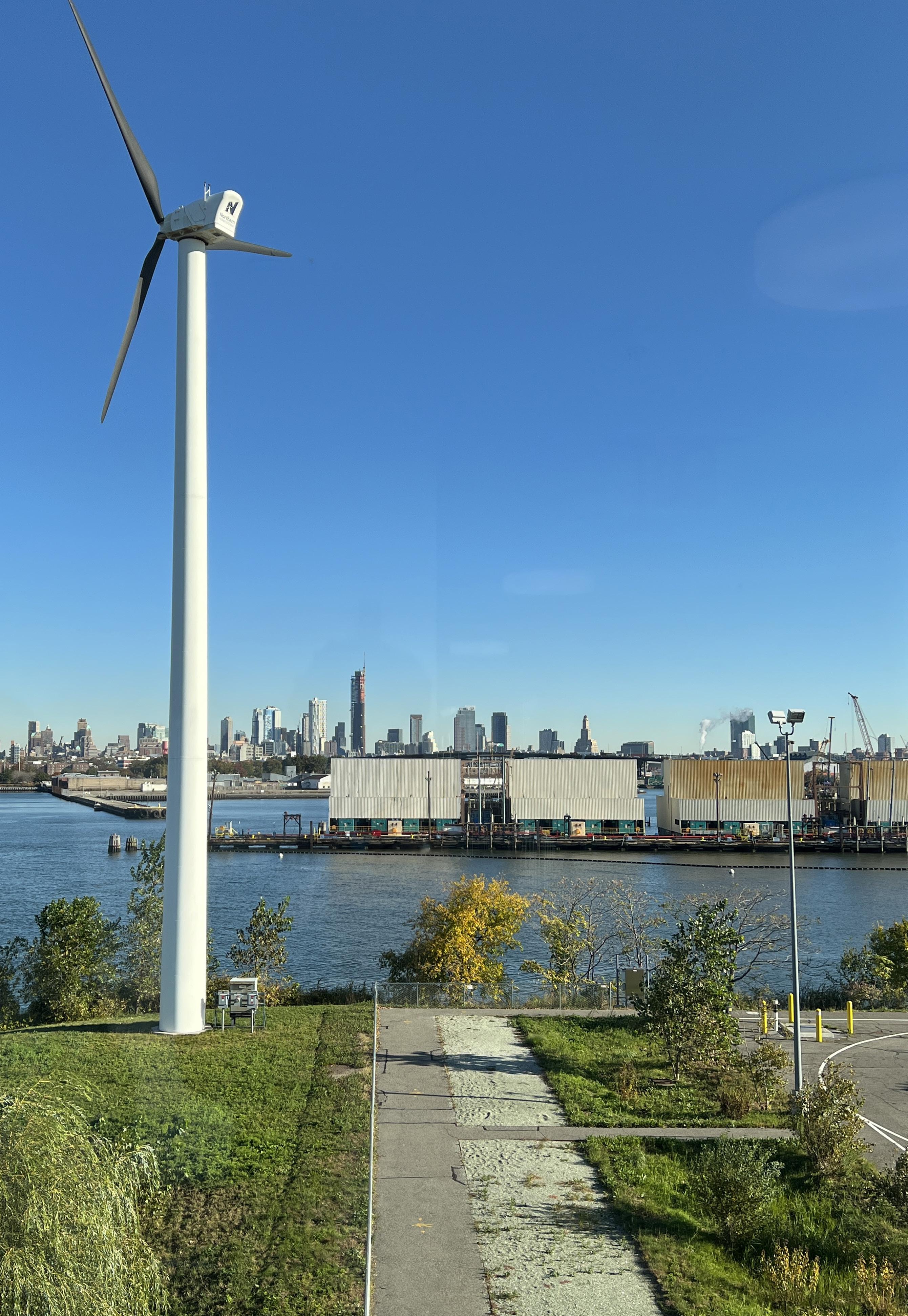
10 Years After Superstorm Sandy
PRATT INSTITUTE’S RESILIENCE WORK AND THE ORIGINS OF THE RAMP INITIATIVE
by Semire Bayatli and Walker Johnston
INTRODUCTION
Late October to early November of 2022 marked the ten year anniversary of Superstorm Sandy, the largest Atlantic hurricane ever recorded, that left a path of devastation—communal, physical, and emotional—along the eastern coast of North America from the Caribbean to Canada. The most populous city in the United States was not exempt from the destruction; in New York City, at least 43 people died, thousands of homes and businesses were damaged, and major flooding and electrical outages impacted households across the metro region, all causing billions of dollars in damage. The disaster forced affected communities to reckon with their own vulnerability to climate change and to focus on planning for increasingly more frequent severe storms. The New York City government took action by “establishing a Mayor’s Office of Climate and Environmental Justice, developing berms and levees along its shorelines, and restoring wetlands.”1 At Pratt Institute, students and professors mobilized, forming the The Recover, Adapt, Mitigate, and Plan (RAMP) project, an initiative which still exists today; its mission is engage with with “frontline waterfront communities in New York City to co-create and accelerate values-based, equitable, innovative, and effective strategies to recover, adapt, mitigate, and plan for the impact of the climate crisis.”2
This article details the formation of the RAMP initiative and is based on an interview, edited for brevity and clarity, with Ronald Shiffman in October 2022.
1 Afridi, Lena P. “10 Years After Sandy, Renters Remain Most Vulnerable to the Impacts of Climate Change,” October 28, 2022. https://www. thenation.com/article/environment/10-years-after-sandy/.

2 “RAMP22 Home.” RAMP Site (blog). Accessed November 24, 2022. https://ramp-pratt.org/.
3 Ibid
2FIELDWORK MULTIPLICITY
Flooding in Red Hook after Hurricane Sandy in 2012.
Photo by Tyler Sparks, Curbed
RAMP ORIGINS
The RAMP initiative formed from a group of Pratt students’ collective reaction to what was the devastating impact of Hurricane Sandy. The disaster required emergency response, and many students contributed by preparing food for frontline workers and isolated community members. Amidst these activist efforts was a sense of both hope and anxiety, along with motivation to do more than making sandwiches—a drive to take action to help communities become more resilient with the threat of future storms.
Faculty in the programs for Sustainable Planning and Development (PSPD)—now the Graduate Center for Planning and the Environment (GCPE)— and Undergraduate Architecture created the RAMP project with this forward-looking viewpoint. Pratt Institute GCPE Professor Emeritus Ron Shiffman, Jaime Stein, and School of Architecture faculty including Zehra Kuz and Deborah Gans, were among RAMP’s founding leaders.
Early work concentrated on coastal communities most impacted by Sandy, including Sheepshead Bay, Red Hook, Coney Island, and the Rockaway Peninsula in Brooklyn and Queens. Collaborative workshops and training sessions, working groups, and academic curricula—including the current Delta Cities Coastal Resilience joint studio in the GCPE and Undergraduate Architecture departments—molded RAMP’s framework. While undergraduate architecture students thought about what new design strategies may make living with and on the water sustainable, planning students created policy proposals.
INTERDISCIPLINARY APPROACH

From Spring 2013 through Fall 2014, graduate and undergraduate studios were set up with funding from the Kresge Foundation to study how to adapt and safeguard shoreline communities in the face of increasing sea levels, severe storms, and habitat loss while preserving their historical identities. Direct engagement, relationship and trust-building, collaboration with community groups in the impacted areas were essential to this. Additionally, RAMP was intentionally designed as an interdisciplinary undertaking, operating with the understanding that change could not occur through solitary labor. Superstorm Sandy served as a stimulus to bring students across disciplines together, which resulted in a new array of classes working on the same projects with the same communities. The classes would meet up to share with one another what they were learning, representing a new pedagogical approach of weaving curricula together. This approach continues at Pratt today.
“Participation must be multi-faceted and has to carefully weave together a set of values that recognize diversity, equity, and justice, addressing the needs and engaging the voices of all impacted. The process of planning is as important as the products of that process and, indeed, if the process is well designed the end product—the places we live in, work in and embrace—will be far better.”
3FIELDWORK MULTIPLICITY
3
- Ron Shiffman
Pillars of RAMP
Community is an important pillar of the RAMP initiative. RAMP aims to be a model for communitydriven academic partnerships, and a way to build capacity to address the present and future climate crises. Significantly, the initiative seeks to highlight the interrelationships of social, racial, and climate injustice— acknowledging that the regions most impacted by climate change are typically low-income communities of color. At the root of the RAMP initiative is a spirit of co-creation and drive to bring together Pratt students, faculty, and local community leaders to create participatory design solutions addressing environmental, social, and economic pressures that can be implemented and replicated in other communities. Ron emphasizes the need for “culturally appropriate public participatory tools that engage people in planning and development processes in such a way as to minimize their alienation and enable them to benefit from all stages of the development process—including being beneficiaries at the end of the process.”4
THE PRATT ETHOS
Embedded in the fabric of Pratt Institute as we know it today is the ethos of community engagement and co-creation. According to Ron, the vision behind this is the belief that the work of architects and planners should be made available to everyone. This approach emerged in the 1960s as a backlash against the school’s curriculum, which focused on esoteric projects that lacked any relation to the declining communities surrounding the Pratt campus. Students in the School of Architecture went on strike to protest the disconnect between the curriculum and communities, and things started to shift.
The Pratt Center, founded in 1963 as the first university-based community planning organization in the United States, embodies this ethos. The center engages on the ground with community-based organizations to combat systemic injustices and foster sustainable development. It does this by utilizing professional talents in urban planning, architecture, design, and public policy. The objectives of the RAMP Initiative and the Pratt Center are both based on the conviction that achieving a community's vision and dislodging stagnant paradigms result from challenging inequities, making courageous decisions, and being receptive to the possibilities that a process of collaborative exchange can produce. Both the planning field and academia have a reputation and history of being extractive, using residents for their research and leaving them with participation fatigue and little to no concrete improvements to their communities. The recognition that partnerships with communities must be sustained beyond the academic calendar is fundamental to RAMP’s approach and lasting impact on the GCPE operations.

4FIELDWORK MULTIPLICITY
FEATURE
4 Shiffman, Ronald, 2021, unpublished, “People, Pandemics, Planning and Participation.”
LOOKING FORWARD
From Ron Shiffman’s personal perspective, consistent effort remains the most important ingredient for success with the RAMP initiative. RAMP illustrates how the path forward in disaster planning, resilience, and adaptation must be a steady, collective effort, built by deep collaboration and leveraging resources across disciplines and communities.


5FIELDWORK MULTIPLICITY
Let The Water In; Srategies for a Resilient Edgemere. Photo by DCCR Studio 2019.
“People change, people go, people die; but if you can sustain the effort, the network and the organization will continue to serve their true purpose.”
- Ron Shiffman, Professor Emeritus, Pratt School of Architecutre, GCPE
FEATURE
Envisioning a Community of Care in The Bronx

A PILOT PROJECT FOR CAREGIVER AFFORDABLE HOUSING FOR A RESILIENT ECONOMY (CAHRE)
By James Tschikov and Kevin Garcia PLAN 820 Land Use & Urban Design Studio
FACULTY

Mercedes Narciso
Jina Porter
Eva Hanhardt
Ayse Yonder
STUDIO MEMBERS
Agata Naklicka
Amelia Clark
James Tschikov
Kevin Garcia
Kieran Micka-Maloy
Leanna Molnar
Lindsey Cassone
Matthew Marani
Michaela Brocchetti
Natt Slober
Nischala Namburu
Rita Musello-Kelliher
Shelby Ketchum
Suzanne Goldberg
INTRODUCTION
Community resilience comes in many forms and affects various sectors of our population. The COVID-19 pandemic exposed gaps in critical infrastructure that presented challenges in public health, community care, workforce, and housing for New York City leaders to address in the years to come. Today, there is a rising need for athome healthcare that is a direct result of the aging and disabled population. New Yorkers aged 65 and older are projected to grow by approximately 41 percent by 2040.1 This is coupled with the overworked, understaffed, and under-resourced home care workforce, who are critical to providing healthcare for the elderly and people with disabilities. The high turnover rate within the homecare industry, as well as the more than 20,000 job openings in the field, are a result of the myriad challenges faced by workers, including low wages, long commute times, and gaps in basic support.2
The Caregiver Affordable Housing for a Resilient Economy (referred to as CAHRE) is a concept based on a nexus between community healthcare needs and the provision of deeply affordable housing for low- and moderate-income healthcare providers. The Pratt GCPE Spring 2022 Land Use and Urban Design Studio built upon the initial framework of the model introduced by the Collective for Community, Culture, and Environment (CCCE) and developed proposals for holistic community care infrastructure working with 1199 SEIU and Highbridge Community Development Corporation (HCDC) in The Bronx. The studio team investigated the need for an integrated care network, approached housing design through a feminist lens, and expanded beyond the limitations of affordable housing programs to develop an equitable model for vulnerable workforce populations.

7MULTIPLICITY STUDIO
1. “Health of Older Adults in New York City” (New York City Department of Health and Mental Hygiene, June 2019), https://www1.nyc.gov/assets/doh/downloads/pdf/episrv/2019-older-adult-health.pdf. 2. “Fastest Growing Occupations,” U.S. Bureau of Labor Statistics (U.S. Bureau of Labor Statistics, September 8, 2021), https://www.bls.gov/emp/graphics/fastest-growing-occupations.htm.
BACKGROUND & CONTEXT
Four faculty members who led and advised the student’s work throughout the studio are a part of The Collective for Community, Culture, and Environment (CCCE) who developed the CAHRE concept. The CCCE is a women-owned and led planning, architecture, and urban design practice and interdisciplinary professional network based in New York City, with projects throughout the tri-state region driven by their mission to develop a sustainable and equitable world.
The CAHRE Model provides strategies that uplift care workers, while also raising awareness of the challenges that this workforce of “Home Health Heroes’’ endured during the COVID-19 pandemic within existing housing and healthcare systems. CAHRE creates opportunities for home healthcare workers to live in close proximity to their clients, facilitates social infrastructure, and encourages community support.
The CAHRE concept developed by the CCCE addresses various elements of infrastructure:
• Hard Infrastructure: The physical systems of housing, open space, and transportation.
• Soft Infrastructure: Institutions that help maintain a healthy economy, which include investing in human capital and serviceoriented systems, such as education, health, finance, security, government, and more.
• Critical Infrastructure: Assets defined as the most crucial to a functioning economy, such as shelter, public health, food, etc.
“Care workers, who are mainly people of color, women, and immigrants, are the backbone of society, especially at times of emergency but their work is undervalued, underpaid, and ignored. CAHRE model addresses the affordable housing issue from a class, race, and gender perspective.”
A PILOT FOR HIGHBRIDGE, BRONX
Highbridge, Bronx was selected for the pilot project of the CAHRE concept due to the high number of home healthcare workers who reside in the neighborhood, and it being a more affordable NYC neighborhood for those working on a lower-wage salary.
As a client of this studio interested in piloting the model, the Highbridge Community Development Corporation (HCDC) owns and manages a stock of senior housing, and has extensive experience developing new housing. HCDC was interested in working with 1199SEIU to help residents become healthcare workers closer to clients needing care.

MULTIPLICITY8STUDIO
– Ayse Yonder & Eva Hanhardt, Studio faculty and CCCE Consultant
In the last decade, the housing shortage in New York City has caused a significant increase in housing costs, in addition to increasing concerns about speculation, maintenance, and overcrowding. Homecare workers face the brunt of these challenges as the majority of the workforce are women, over 70 percent are Black or Hispanic, 80 percent are foreign-born, and 72 percent live in multi-generational households.3 Furthermore, homecare workers struggle with low wages, with a

To understand the needs of the community, the studio conducted three focus groups: one with home health aides from Highbridge, one with home health aides from across NYC, and one with seniors living in HCDC buildings. Focus group participants answered questions about costs of living, housing conditions, community amenities, mobility, and emotional connection to the community and work.

Some major takeaways were that home health aides are dedicated to their jobs and love helping people, often staying later than expected to assist their clients; however, they endure long commutes, are underpaid, and lack employment stability. Highbridge seniors enjoy their neighborhood and its sense of community, but expressed a desire for more nearby amenities since traveling across the neighborhood’s hilly topography is difficult. Overall, home health aides serve as the first line of care for millions of people, yet they are severely undervalued, underpaid, and excluded from the traditional health care system.
median annual income of $22,000.4 This speaks to the critical need of the CAHRE concept to address these disparities by ensuring permanent housing affordability and long-term community stability for home health aides and their clients alike. Through a pilot project for the CAHRE concept in The Bronx, the studio aimed to establish the feasibility of this model citywide through the social housing proposal and community care networks.

9MULTIPLICITY STUDIO
3. “Home Care Workers: Key Facts (2016),” PHI National, September 1, 2016, https://www.phinational. org/resource/home-care-workers-key-facts/.
4. Isaac Jabola-Carolus, Stephanie Luce, and Ruth Milkman, “The Case for Public Investment in Higher Pay for New York State Home Care Workers: Estimated Costs and Savings,” CUNY Academic Works (CUNY Graduate Center, March 2021), https://academicworks.cuny.edu/gc_pubs/682/.
ENVISIONING A NEW SOCIAL HOUSING MODEL FOR NYC

Building on lessons learned from the existing conditions research, the studio developed six main components of the CAHRE Model: housing type and financing, participatory planning, design considerations, community services, ground floor commercial, and operations and maintenance. Each part of the model formed a framework that could be feasible in neighborhoods across New York City.
Social housing is a model that ensures permanent affordability, social equality, and democratic resident control by shielding housing from market pressures.5 This studio proposes that the CAHRE Model be implemented as a social housing program to avoid the competitive and unsustainable Low-Income Housing Tax Credit (LIHTC) program, which does not allow for permanent affordability.6

In a Social Housing program, land acquisition and construction would be subsidized by the city’s floating bonds, investing directly in the project.7 Buildings would be owned by the City and managed by either HCDC or 1199SEIU, allowing for greater flexibility in area median income (AMI) thresholds and permanent affordability. Opening the housing to all essential workers would allow professionals from various AMI thresholds to subsidize operations and maintenance costs.

A land bank could provide land at a low cost to the city, requiring less upfront investment. The NYC Comptroller Brad Lander is advocating for a citywide land bank and a CAHRE project could serve as a pilot development on a land bank lot.8 In the long term, the land could be transferred to the community through a Community Land Trust, perhaps in partnership with the existing Mott Haven-Port Morris Community Land Stewards CLT.9
Neighborhood-Specific AMI
Creating neighborhood-level AMI can create truly affordable housing that would make CAHRE successful. Currently, HUD calculates the median income for every metro region. In 2019, the 100 percent AMI level for the New York City region, which includes Putnam, Rockland, and Westchester Counties, was $106,700 for a family of four,10 but carve-outs for Westchester and Rockland Counties11 have allowed for developers to build affordable buildings at higher thresholds to cover operating costs. While a citywide AMI may not help, a Highbridge-or Bronx-specific AMI carve-out would reduce income eligibility for affordable housing permitting more rental units with deeper affordability and providing homes for home care workers.
10MULTIPLICITY STUDIO
Social Housing in Vienna. Photo by Margherita Spiluttini, Architekturzentrum Wien
Essential Workers
Low AMI Essential Workers
Home Care Workers

CAHRE as a Community Facility
Home care workers are critical to care infrastructure. If CAHRE housing is labeled as a community facility per the NYC Zoning Resolution, housing for these workers could fall under this definition.12 There are 2 approaches to categorizing CAHRE Housing as a community facility. 1) Leverage the precedent of supportive housing to define CAHRE housing as an institution with sleeping accommodations. 2) Categorize housing for home care workers near senior housing through a zoning amendment. These approaches use the classification of non-profit hospital dwellings as community facilities.13 Ultimately, these approaches require 1199SEIU to act as a housing developer or manager, which has precedent in their development of 1199 Plaza in East Harlem in 1975.14
WorkForSocial Housing
The proposed model combines the concepts of Social Housing and Workforce Housing. The “Workforce” denotation refers to the tenant housing demographic, while “Social Housing” is the Financing Model. This ambitious vision requires regulatory changes and advocacy by 1199SEIU. For protection, 1199SEIU would manage the building and provide union priority to home care workers by categorizing it as a community facility. Integrating a credit system into union benefits could help home care workers with families to pay for their larger rental units, which tend to be more expensive. Using the money generated through the credit system to pay back the construction loan can keep larger units more affordable without increasing rent.

“Social Housing in the U.S.,” Community Service Society of New York, February 18, 2020, https://www.cssny.org/news/entry/social-housing-in-the-us.
6. Stephanie Sosa-Kalter, “Maximizing the Public Value of New York City- Financed Affordable Housing,” Association for Neighborhood and Housing Development, October 10, 2019, https://anhd. org/report/maximizing-public-value-new-york-city-financed-affordable-housing.
7. “Vienna’s Unique Social Housing Program,” Office of Policy Development & Research PD&R Edge (HUD USER, 2014), https://www.huduser.gov/portal/pdredge/pdr_edge_featd_article_011314. html.
8. Sarah Holder, “Staking New York City’s Future on Social Housing,” Bloomberg CityLab, January 29, 2021, https://www.bloomberg.com/news/articles/2021-01-29/a-plan-to-boost-public-housingin-post-covid-nyc.
9. “Community Land Trust,” South Bronx Unite, accessed November 14, 2022, https://www. southbronxunite.org/community-land-trust.
10. “AMI - New York - Hud Effective Date 042419 - Safeguardcredit.org.” AMI - New York - HUD effective date 042419. The SafeGuard Group, April 2019. https://www.safeguardcredit.org/wp-content/ uploads/2020/02/AMI_Safeguard.pdf.
11. Murphy, Jarrett. 2017. “The Secret History of Area Median Income.” Shelterforce. April 25, 2017. https://shelterforce.org/2017/04/25/secret-history-area-median-income/.
12. “NYC Planning Zoning Resolution,” NYC Department of City Planning, 2021, https://zr.planning. nyc.gov/. 13. Ibid.
14. Adam Thalenfeld, “1199 Plaza,” NYC URBANISM (NYC URBANISM, April 30, 2018), https:// www.nycurbanism.com/brutalnyc/1199plaza.
11MULTIPLICITY STUDIO
5. Oksana Mironova and Thomas J. Waters,
DESIGNING FOR COMMUNITY CARE INFRASTRUCTURE MODELS FOR URBAN DESIGN


NEW BUILD MODEL: A COMMUNITY HUB


The CAHRE model incorporates a feminist, working-class lens to address the current housing shortage for care workers. This hybrid development model incorporates standard and shared living spaces to be adaptive to care work and provide flexible commercial spaces. To achieve a radical re-imagining of housing for home care workers, some challenges must be overcome, including the lack of vacant lots in a densely populated area, construction costs for building a new development, and existing policy and financing constraints.
From three viable sites across the Highbridge neighborhood that were identified, the site on Ogden Avenue and 167th Street showed the most potential as a community hub. Although some of the neighboring lots are privately owned, HCDC could work with the owners to acquire the lots and offer opportunities to provide community benefits. If all the lots are acquired, a building with over 200 units can be constructed
on the site. Due to many homecare workers living in multi-generational households, the studio recommended that units built be two-bedroom and three-bedroom apartments with balconies and flexible layouts. The studio also included a small portion of efficient micro-studios that would open up to communal spaces for shared amenities to attract younger individuals to the field, provide a low-cost efficient living, and serve as entry housing for recent immigrants.
The site’s commercial zoning permits ground-floor retail or additional community space that could add to the area’s vital facilities and amenities, such as a daycare center and grocery stores, that can integrate with potential new open space to provide more community benefits. Lastly, the studio recommended using massive timber and passive housing design to drive down construction costs, reduce carbon emissions associated with new construction, and save on heating and cooling costs.
12MULTIPLICITY STUDIO
SITE FEASIBILITY
Highbridge CAHRE Model site plan for proposed development on Ogden Avenue and 167th Street. Source: Pratt GCPE Spring Land Use Studio, 2022
Developable square footage per lot
Developability including grade, terrain, and vacancy of lot
Commercial overlay zoning
Ease of lot acquisition
Proximity to transit
Access to parks and open space
Low environmental hazard
Proximity to grocery stores
Proximity to schools and daycare
Promixity to senior facilities
ADAPTIVE REUSE MODEL
The adaptive reuse approach to the CAHRE model is a form of redevelopment that focuses on renovating, upgrading, and retrofitting existing residential buildings, and considers adaptive reuse to repurpose commercial or community buildings. By utilizing this approach, developers can reduce their environmental impact, preserve the heritage and identity of the neighborhood, and save money on costs associated with demolition, construction, and new materials.

Retrofitting a building can also lead to healthier and more sustainable living environments. Investments, such as high-performance building envelopes and thermostat controls, can reduce energy costs to make for warmer winters and cooler summers. Meanwhile, electrification of cooking, heat, and hot water systems eliminates the harmful air pollutants that many routinely breathe in homes.15 Solar energy and battery storage reduce energy costs and make electricity resilient to grid-wide outages.
The studio focused on two of three potential sites, 987-989 Ogden Avenue and 368 E 148th Street. Notwithstanding both sites’ individual limitations, the sites were chosen due to their close proximity to existing community facilities, open green space, and transit. To meet the needs of home care workers using two-bedroom layouts of 1,100 square feet and three-bedroom layouts of 1,400 square feet between, the studio determined between 13 and 17 apartments can be built at 987-989 Ogden Avenue, and between 11 to 14 apartments can be built at 368 E 148th Street. Furthermore, using the ground floor for commercial purposes could produce additional monthly revenue to help maintain ownership of the building or offset home care workers’ rents.
13MULTIPLICITY STUDIO
15. “8 Elements of a Green and Healthy Home,” Green & Healthy Homes Initiative, November 6, 2020, https://www.greenandhealthyhomes.org/homeand-health/elements-green-healthy-home/.
NEIGHBORHOOD CARE NETWORK
The neighborhood care network model fuses the new build and adaptive reuse models to distribute housing units among multiple buildings with newbuild community facilities and create connected, healthy, and resilient communities. Integrating housing for home care workers throughout the neighborhood creates a flexible and replicable network of various housing types, resources, and services to provide individualized tenant support to meet tenant needs in different locations. This model can prioritize filling individual apartment vacancies in existing residential buildings, which will reduce expensive upfront costs.
This model employs a phasing approach that begins with a unit placement program, similar to the new build model, and progresses to building out a brick-and-mortar network of services in vacant and underutilized sites throughout the neighborhood. Existing sites suitable for this network model should contain residential square footage, be near accessible subway stations, and neighbor existing community facilities. These facilities should include services such as childcare, workforce training, and home care resource centers.

The studio spotlighted two potential sites to meet some essential needs identified by home care workers. The first is 1400 Cromwell Avenue, an R8A zoned lot, fit for a resource center on the ground floor and housing units above. The second location, located on the corner of Edward Grant Highway and Plimpton Avenue, could be built for seniors and achieve another goal of the CAHRE model. This lot is situated near other HCDC properties and can include senior-focused amenities.
“CAHRE model imagines a communitybased health and care system for creating healthy, resilient, and caring communities in the future. Providing deeply affordable housing for healthcare workers as part of basic neighborhood infrastructure would address their housing needs, freeing up time and opportunities by living in proximity to their potential clients. It would address health care needs of the rapidly growing senior and disabled population, and the community, especially at times of emergency.”
– Studio Faculty and CCCE Consultants
14MULTIPLICITY STUDIO
Proximity analysis of youth facilities for home care workers for the Neighborhood Care Network model. Source: Pratt GCPE Spring Land Use Studio, 2022.
CONCLUSION
This studio’s proposals and recommendations would strengthen and expand neighborhood infrastructure by incorporating an undervalued but critical workforce into the healthcare system. Through the development of deeply affordable housing with dignified accommodations and vital amenities, the CAHRE Model allows communities like Highbridge to establish a localized care workforce and cultivate neighborhood-based resilience. The three proposed models are examples of how to implement the CAHRE Model in New York City and beyond to allow home health aides to care for their neighbors, clients, families, and, most importantly, themselves.

Community Love Over Capitalism
A REFLECTION ON THE RECOVERY OF NYC’S NIGHTLIFE ECONOMY
 by Mariah Chinchilla
Summer 2022: A time and space where the history of house music, Beyoncé, and the state of our urban cities can coexist. In the two years since I completed my thesis, titled “Barriers, challenges... in NYC,” the idea of land use as a tool that systematically displaces nightlife culture is no longer a fringe issue; it has become a movement spurring policy changes to ensure its survival and a nucleus for emerging solutions to solve intersectional urban planning issues.
Cities across the United States are reckoning with the radical disparities that they have perpetuated (see: 'A Lesson in Discrimination': A Toxic Sea Level Rise Crisis Threatens West Oakland by Ezra David Romero for KQED KQED1) through policy, land use regulation, and resource or funding allocation. The cracks in the systems that run our cities gave in when hit simultaneously with the COVID-19 global pandemic, the persisting climate crisis, and the scramble to achieve racial equity all at once.
In my research, I wanted to explore how mainstream culture, fashion, and music begins in spaces like after-hour art venues, bars, restaurants, and nightclubs, and how the existence of these places provide a sense of belonging for many people, but especially for Black, Indigenous, and persons of color (BIPOC). In NYC, nightlife is a sacred environment where one makes connections and finds community. By exploring the historic nexus between cultural movements and participation in nightlife, the study found night spaces play a critical role in nurturing social movements and civic participation including but not limited to civil rights, Gay Liberation, reproductive rights, education, and Black Lives Matter. However, what it also found (and what I innately knew), was while BIPOC and other marginalized populations are often the creators, originators, and pioneers of emerging trends, they are also more likely to be vulnerable to illegal harassment2 and over-policing that leads to the displacement and suppression of culture.
 A night out on the dancefloor of Nowadays NYC in Queens. Photo by Mariah Chinchilla
1Romero, E.D. (2022) 'A lesson in discrimination': A toxic sea level rise crisis threatens West Oakland, KQED. Available at: https://www.kqed.org/science/1980255/a-lesson-in-discriminationa-toxic-sea-level-rise-crisis-threatens-west-oakland (Accessed: October 22, 2022).
2 Becker, J. and E., Conte. (2018). Flawed Findings Part I: How NYC’s Approach to Measuring Residential Displacement Risk Fails Communities. Pratt Center for Community Development Retrieved February 15, 2020, from https://www.prattcenter.net/research/flawed-findings
A night out on the dancefloor of Nowadays NYC in Queens. Photo by Mariah Chinchilla
1Romero, E.D. (2022) 'A lesson in discrimination': A toxic sea level rise crisis threatens West Oakland, KQED. Available at: https://www.kqed.org/science/1980255/a-lesson-in-discriminationa-toxic-sea-level-rise-crisis-threatens-west-oakland (Accessed: October 22, 2022).
2 Becker, J. and E., Conte. (2018). Flawed Findings Part I: How NYC’s Approach to Measuring Residential Displacement Risk Fails Communities. Pratt Center for Community Development Retrieved February 15, 2020, from https://www.prattcenter.net/research/flawed-findings
According to the National Independent Venue Association (NIVA), which represents almost 2,000 music and performance venues across the U.S., an estimated 90 percent of venues were faced with the possibility of permanent closure due to the pandemic. In New York City during the fifteen years before 2020, over 20 percent of nightlife businesses closed their doors due to rising real estate prices, zoning pressures, increasing operating costs, noise complaints, and gentrification.3 These barriers were and still are too much for small businesses to bear, especially when compounding these issues with today’s inflation and rising costs.
For cities, this places yet another strain to provide affordable housing, avoid gentrification, and support the economic development and the infrastructure needed to nurture thriving local artist communities. Our challenge now as planners is to do the critical work to redress the harm and ensure that history does not repeat itself. Nightlife activism can find a home in planning following the lead of folks who are activelyadvocating for solutions in economic policy like commercial rent stabilization, tactical urban design, and dedicated investments to create democratic and cooperativelyowned urban spaces that can thrive both day and night.

FIELDWORK 18 -
3Economic Impact Study of NYC Nightlife— MOME. (n.d.). Retrieved February 24, 2020, from https://www1.nyc.gov/site/mome/ nightlife/economic-impact-study.page
McCarren Park Pool before restoration into a vibrant community space.
Photo by Larry Racioppo
In March 2020, quarantine and social distancing were decreed in Havana, important in these times when COVID-19 threatens the health and life of all. From that moment, those who were lucky, were able to work from home. Homes turned into offices, schools, play spaces and beyond. Before Covid, the concept of the “home office” created enthusiasm and was desirable. We used to imagine that working from home would be productive because of the calm felt in one’s own home-the overwhelming silence and the feeling of autonomy provided by being able to decide what is worth your time, the lack of pressure from comparison to coworkers.
Protecting clubs, bars, and venues— particularly those owned by native residents and local communities of color—means preserving and stabilizing New York City’s cultural fabric. These efforts can also encourage public art and activism, creating a pathway towards civic engagement and deployed as an anti-gentrification strategy.

Since 2020, the improvement and progress has been undeniable. NYC’s nightlife has made a recovery, mostly due to grassroots activism, as well as real policy change from the Office of Nightlife (ONL) at the Mayor's Office of Media & Entertainment (MOME) leading to direct services, including direct services including mental health support for service workers and publishing quarterly transparency reports on Multi-Agency Response to Community Hotspots (MARCH).
Today, weeks into a nearly universal shift to working from home, for those who are able, the previous appeal of the home office is waning. Perhaps the discomfort comes from the over exhaustion of daily routines or because what was previously your “corner” - has become the place where you least want to be. Maybe it stems from family feuds, a lack of privacy, or the dissolution of tranquility, now drowned out by a continuous stream of distractions. Each minute feels as if everything is happening to you. You may have plenty of space or just the bare minimum: a place to get up from your chair, go to the bathroom (if no one is already waiting), to the kitchen (if there is space) , to stretch out on the sofa (when it’s not occupied), or to look out the window.
In July 2022, Mayor Adams suspended the city’s 25 percent surcharge businesses pay on state liquor licenses for a year, which will help businesses citywide save an estimated $6.5 million over the next year.
Across the country, the City of San Francisco has championed its Cultural Districts and Legacy Business programs—which both launched during the 2020 pandemic—as joint agency efforts to support community development, placemaking, and placekeeping. The Cultural Districts program’s vision is to preserve, strengthen and promote cultural communities, while the Legacy Business program focuses on supporting legacy businesses, nonprofits, community arts, and community-led traditions. Both programs aim to support specific cultural communities and ethnic groups that have been historically discriminated against, displaced, and oppressed.
19FIELDWORK
 Photo by Mariah Chinchilla
Globally, the movement is gaining momentum as well. The Global Nighttime Recovery Plan is a collaborative, practical guide for cities that are interested in developing safe and feasible strategies to reopen and reactivate their creative and night-time economies. The guide was published with the input of 130 practitioners, academics, public health experts, advocates, and service representatives from more than 70 cities all over the world, and is meant to be an interactive platform to share frameworks, tools, and practices among cities to map a new future for nightlife.
If spending time with your family is already somewhat awkward, it can be compounded by working from home. Tight quarters, shared resources, and lack of personal space can create conflict and discomfortseeing your mother running from here to there doing housework like an hormiga loca, your father watching TV and your brother playing and screaming. During times like these, perhaps your mother exclaims,
The solutions to our most complex urban dilemmas aren’t so far out of reach. As planners, we should follow in the footsteps of advocates by leaning into the sticky intersections of our work. Now is the time to take in everything, all at once, and see the bigger picture. Once we understand the value of community engagement and the generational expertise of those who have been systematically silenced is when we will begin to build a more equitable future for us all.

21MULTIPLICITY FIELDWORK
Photo by Mariah Chinchilla
Reclaim/Reuse/Recycle!
A CLINTON HILL HERITAGE DOCUMENTATION STUDIO
 By Ethan Brown, Mahnoor Fatima, Tara Hopp, Megan Maize, Katherine Pioch, Diego Rivadeneira, Alison Weidman, Jeremy Ziegler
PR 839 Spring 2022 Studio
FIELDWORK
Chris Neville
Rebecca Krucoff
STUDIO MEMBERS
Ethan Brown
Mahnoor Fatima
Tara Hopp
Megan Maize
Katherine Pioch
Diego Rivandenra
Alison Weidman
Jeremy Ziegler
Welcome to Clinton Hill, Brooklyn! Or is it Fort Greene? Or Bedford-Stuyvesant? The Gold Coast?
The study area that we surveyed in January 2022 for our Spring Heritage Documentation Studio has been known by many different names over time, reflecting the flexible boundaries and diversity of functions and people we observed. Throughout the semester we kept coming back to a foundational question: what is this place?
The answer changes based on the respondent and lies somewhere between the historic buildings and the people here today. To answer the question, we surveyed examples of historic spaces that evolved to meet contemporary social purposes in and around the study area. What we found were fascinating stories of wealthy industrialists, working-class immigrants, working women, Vaudeville actors, artists, and community gardens.
Pratt Institute sits at the center of our study area, and for our project it was a way to name and define the neighborhood. The Pratt Area saw a second wave of growth and development in the late 19th and early 20th century with an upper-class corridor developing on Clinton Avenue in the North; in the rest of the study area, housing was built by local developers for middle- and working-class families in the 1870s.

23MULTIPLICITY STUDIO
FACULTY
As a wave of industrialization in the late 19th and early 20th century washed over the Pratt Area, a wellspring of new forms of transportation into and out of Brooklyn developed, including the Brooklyn Bridge (completed in 1883) and the Myrtle Avenue Elevated Line (which ran in 1888). In the decade that followed, the gradual departure or death of the once-large industrialist community—paired with a new wave of migration within and immigration to the United States spurred on by World War I and urbanization— resulted in a large demographic shift in the community.
In the 1950s–1960s, the area experienced another shift from being a majority-white community to one chiefly populated by poor and workingclass people of color. This “white flight,” catalyzed by post-war federal housing policies that


24MULTIPLICITY STUDIO
The Vaudeville Peerless Theatre declining in the 1960s. Source: CinemaTreasures
The Artist’s Studio, formerly a candy factory. Source: Jason Schmidt

 Myrtle Ave Elevated Line Construction. Source: NY Transportation Museum (above)
both encouraged disinvestment in cities and white settlement in the suburbs, was used as a rationale for the demolition of swaths of neighborhoods for urban renewal projects.

By the 1960s and into the 1970s, political and social policies stimulated the deindustrialization and disinvestment that left the Pratt Area a stressed and fragmented version of its former self. The area was sustained and gradually mended with the continual efforts of neighborhood leaders, community-led block associations, and ambitious creatives, which helped orchestrate the area’s resurgence as the vibrant commercial corridor one experiences today. The Pratt Area today is a predominantly urban residential neighborhood hosting two colleges: Pratt Institute and St. Joseph’s University. The Myrtle Avenue commercial corridor lies
at the north with many businesses (art stores, galleries, bars, and restaurants) catering to residents and the Pratt student-base.
The buildings, like the people they serve, require reinvestment and care to evolve and survive. Whether adaptive reuse gives an abandoned structure a new life or reuses it for a new function based on economic and social changes, what is important is that the built fabric of the past continues to exist as a space where the life of the community can continue to unfold for many years to come.
Our methodology for this conclusion has come out of our inductive historical documentation process. It started by dividing up the larger study area into smaller sections and assessing individual sites for recurring patterns. However, moving into the demographics and archival work, we noticed
a changing pattern of people within the census data, and a continuous diversity of people from a wide range of ethnicities and social strata. Because these changes were so widespread and consistent in the data, we could assume that there were broader historical patterns to explain why certain communities and businesses settled in their respective locations.
We realized that we needed to zoom out and look at wider historical contexts and archival research. We looked at fire insurance maps, newspaper archives, and other historical documents to understand the primary forces of change. When that became too abstract and distant, our conversations with the stakeholders from the Myrtle Avenue Business Improvement District and the Myrtle Avenue Revitalization Project helped bring a lived experience to the
26MULTIPLICITY STUDIO
Methodology Visualization
story we were uncovering on maps. This process helped us uncover three kinds of largescale change: physical (the changes of the buildings), historical (connecting to the wider history of Brooklyn and New York) and social (the lived experience and culture of those who long lived in the area).


The term ‘adaptive reuse’ arose as a thread connecting the physical changes witnessed in the neighborhood to larger historical changes and the micro-social changes experienced by those in the neighborhood. Adaptive reuse was the most apt term to describe the historical developments in the area and works as a phrase commonly accepted in architectural practice and history to describe buildings that have changed in function or structure over time.
In How Buildings Learn, Steward Brand explains how all buildings on some level have to adapt to their external environments, contrary to the idea that a building is ‘fixed’ in space and time.1 The term ‘building,’ much like the term ‘adaptation,’ speaks to not only the verb and noun (that which is being built or adapted) but also the active
effort to build or adapt. Many see adaptive reuse as a positive force which prevents the wastage of existing buildings and counters any further environmental degradation that may occur when building a replacement. Adaptive reuse, however, has a dark side tied to the devastation that came with urban renewal and gentrification. Many have lost their homes, businesses, and communities due to these processes, and could not return to their homes due to high rents and
27MULTIPLICITY STUDIO
Fire Insurance Map of Pratt. Source: Tara Hopp


MULTIPLICITY
1940s Tax
Photo of Reinkin Dairy (above), Reinkin Dairy Building Today; credits: Jeremy Ziegler
mortgages. Our interpretation of adaptive reuse hinges on not only physical changes like remodeling or conversion, but also the way that relationships between spaces—and the people who use them—are changed due to changes in the larger area.2 Sociologist William H. Sewell explains that our built environment informs our social experience, thus as the environment changes, cultures and institutions change their practices over time.3 Heritage preservationists like Dolores Hayden also adopt such frameworks by emphasizing the need to consider all aspects of social histories before adapting and restoring buildings, because simple materiality cannot explain the context.4 Within the preservation field more specifically, adaptation is defined by the National Trust for Historic Preservation as: “the process of converting a building to a use other than that for which it was designed.”5 We are trying to expand beyond this
definition, and use adaptation as a radical tool. This type of adaptation is the spontaneous, user-led transformations of existing historical buildings that create shared meanings through use. It is these changes that inform our use of adaptive reuse and vision of it through a bottom-up perspective rather than the real estate and economically-driven one with which it is usually associated.
Our study focused on the narrative of buildings, their builders, occupants, and workers. The changes to the buildings are often unplanned and have greater repercussions than imagined by individuals. It was our responsibility to uncover as many changes as possible, and to give agency and justice to all community members involved in the production of the space. We highlighted the main eras of change that prompted new waves of adaptive reuse which we used to categorize the overlapping historic eras of Clinton Hill:
Urbanization (1801-1933), Industrialization (1901-1941), Urban Renewal (1935-1968), and Cultural Shifts (1920-2004).
We uncovered stories of pain, resilience, economic prosperity, and diversity that mirrored the wider urban history of New York and the United States as a whole. We also began with walking as a spatial pedagogy. Such embodied, bottom-up, and communitydriven spatial approaches have been spearheaded by the likes of Henri Lefebvre, Jane Jacobs, and Michel de Certeau. Through our compiled tour and Spotify playlist, we invite those interested to walk the Pratt Area and learn the stories that are hidden by changes and time. We hope to inspire anyone with an interest in their community to actively participate in its reinvention, imagine collaborative futures, and transform spaces to preserve them for the future rather than just demolish the past.

29MULTIPLICITY STUDIO 1. Brand, Stewart. How Buildings Learn. New York, NY: Penguin Publishing Group, 1995. 2. Brooker, Graeme, and Sally Stone. Rereadings: Interior Architecture and the Design Principles of Remodelling Existing Buildings. London, UK: RIBA Publishing, 2014. 3. Sewell, William H. Logics of History: Social Theory and Social Transformation. Chicago, IL: University of Chicago Press, 2005. 4. Hayden, Dolores. The Power of Place: Urban Landscapes as Public History. Cambridge, MA: The MIT Press, 1995. 5. Murtagh, William J. Keeping Time: The History and Theory of Preservation in America. Hoboken, NJ: John Wiley, 2006.
Thesis
Historic Preservation
THE IMPERMANENCE OF THE VODOU RELIGION IN THE HAITIAN DIASPORA
by Claude Jeffrey Charles-Pierre Spring 2022
If one were to ask a Haitian in East Flatbush, Brooklyn where is Gran Bwa located, they will tell you it’s in Prospect Park near the Parkside Avenue entrance. They may point you in the direction of the lake if they are near or in the park. If you were not familiar with what goes on at Gran Bwa, it would be hard to find this special and sacred place in the community. The meaning of Gran Bwa is large tree/wood and the spirit of trees.

Raised in a Protestant household, Haitian immigrant and artist Deenps Bazile moved to East Flatbush, Brooklyn in 1979. Deenps lives a short walking distance from Prospect Park near the Parkside Avenue entrance. In an interview, Deenps explains how the sounds of drums and a spirit guided him to Prospect Park near the south section of the lake to carve a sculpture from a large tree stump that was about four feet high and at least four feet wide. Deenps carved a large human head, two miniature human faces, a lion, and a Legba. A Legba is a Lwa (god) in Haitian Vodou.
The park’s natural elements, such as the lake and how the sun and wind reflect and move the trees, remind him of being in Haiti. This is how this site became known as “The Gran Bwa” site in Prospect Park. Haitians in the community began to congregate every weekend at Gran Bwa and still do to this day. Deenps became known as Neg Gran Bwa (Man of Big Tree). Deenps recalls the local Haitian Protestants against him carving the tree stump. While watching him carve the tree stump they began to chastise him for bringing evil to the Prospect Park area. Not too long after that, the sculpture was vandalized and destroyed by someone lighting it on fire. The remains of the carved tree stump eventually were chopped, adding to the destruction of the Legba sculpture. Today, there is only the outline remnant of the Gran Bwa sculpture, and no one knows the exact reason why it was destroyed. Some speculate that the neighbors did not like the weekly gatherings or did not want Vodou ceremonies at the park. Neg Gran Bwa says, “The sculpture was removed but the spirit of the Legba is still present.” Today there are three large stones purposely placed at the location of the original Gran Bwa woodcarving.
THESIS31MULTIPLICITY
Gran Bwa sculpture site at Prospect Park Photo: J. Charles-Pierre
One can argue that this act of vandalism affirms Vodou as part of the emergence of the “despised history” that Andrew Herscher conceptualizes in “Counter-Heritage and Violence.” Herscher writes about the tangible heritage of churches and mosques that were vandalized or destroyed by its counterpart for the erasure of that heritage which results in a counter heritage1.
The Vodou religion and its intangible practices are highly susceptible to being erased because of its non-physical presence and consequently being memorialized in either the built or natural environments. Traditional Vodou ceremonies are practiced based on memory and memorialized through oral histories mostly near a body of water or in the woods. The marginalized history and rituals


of Vodou in the environment have endured adversity for several centuries despite the counter heritage that it faced. If the tangible places of worship were removed (church, mosque, temple) from Catholicism, Judaism, Islam, their rituals would still exist. These spiritual religions are still practiced today because it is about the belief system that remains in existence. How can Vodou’s religious practices or ceremonies in non-traditional environments or spaces kept in memory be documented or archived? What is the role of preservation in capturing these moments?
My work aims to raise awareness of the counter heritage Vodou that Vodou continues to endure while embracing and documenting the cultural heritage traditions of Vodou that is ingrained in the daily life of the Haitian community.
1 Andrew Herscher, “Counter-Heritage and Violence”: Future Anterior: Journal of Historic Preservation, History, Theory, and Criticism, Winter 2006, Vol. 3 No. 2(Winter 20006), pp 24-33 University of Minnesota Press
The concepts of co-production and hybridity can be used as a lens to investigate the cultural heritage of Vodou in the Haitian Diaspora in Brooklyn. They can build an understanding of heritage that collapses the here/ now and there/before between the (then) Bois Caïman ceremony in Haiti and the (now) celebration of it in Brooklyn and between the (there) Botanicas in Brooklyn and (before) temples in Benin West Africa. Co-production of Vodou ceremonies is simulated in an environment that is different from its origins, but the rituals remain in existence. The hybridity of Vodou in Haiti and Brooklyn stems from a cross between what and how it was practiced in the different regions of West Africa. ADAPTATIONS
CO-PRODUCTION
ACROSS TIME & SPACE


TRANSFORMATIONS

THESIS 33 -
Photos: Montrose-Louis; Caterina Cleric, The Guardian Photo: Kesler Pierre
Gran Bwa sculpture. Photo Courtesy of Deenps Bazile
The understanding of placed-based heritage elsewhere and its ethos of hybridity can be recognized by its necessary diversity and constructive impurity. Discovering that my Haitian ancestors derived from West Africa either from Benin, Togo, the Kongo, or Dahomey Kingdoms, led me to the realization that they all have the Vodou Religion in common. The distinct altars of worship, outfits of the dancers, the beating of drums, and singing during offerings, all are culturally co-produced in a built or natural environment. The constant adaptation, remaking, and transformation of the Vodou Religion from the past, present, and future is the makeup of its cultural-religious heritage.
Since 1992, a few Haitians, a few Haitians from the recently-designated Brooklyn community “Little Haiti” adjacent to Prospect Park, celebrate the Bois Caïman ceremony annually in August to commemorate the anniversary of the 1791 insurrection of the enslaved Africans in Haiti that catapulted the Haitian Revolution. This makeshift, outdoor cultural meeting space occurs at the Gran Bwa site. The wood sculpture that bore its name is no longer at the location, but the site is still used as a gathering place for the Haitian community to bond and experience the healing power of the Gran Bwa spirit associated with trees, plants, wind, and water.

The yearly celebration of the Bois Caïman ceremony at Prospect Park Lake in Brooklyn is in danger of being eliminated due to the lack of awareness of the general public, the migration of Haitians to the suburbs, the gentrification of the surrounding neighborhoods, and the proposed capital improvement of Prospect Park Lake by the New York City Department of Parks & Recreation. Preserving this makeshift, coproduced space is imperative imperative and underscores the importance of
viewing place-based heritage in a way that embraces hybridity and coproduction across time and space and that builds off the practice and ethos of Vodou. Religious practices or ceremonies that occur in non-traditional religious environments should not be excluded from Preservation. The practices and history of Vodou as part of the Haitian Diasporas culture is fundamentally relevantto the current conversations of equity and inclusion in the Historic Preservation space.

Reimagining Our Streets: What We Resisted, Adapted, and Reclaimed in Brooklyn
Prospect Heights Open Streets: Community Led, Community Driven
By Semire Bayatli and Walker Johnston UPM609 Lan Analysis of Public Space Spring 2022 Studio
An architectural project first emerges as a problem and a design opportunity. The project is a journey that can be done at many scales, from interior design to city design and planning. The problem and opportunity turn into an idea in the hands of the designer, then a project as a team works collectively, and eventually a real building, structure, or place with the coordination of many different disciplines. All of these stages are a process and these processes require planning. However, sometimes the project does not arrive on time, even if everything is planned. Given the complexity and challenges of humanity, disasters, pandemics, and wars that hurt different parts of the world cannot be planned, despite our best efforts to anticipate and prepare. In spite of these unplanned processes, humanity reveals its power to heal. It resists, stretches and rebuilds, and a new city experience emerges.
In 2020 our entire world shifted with the onset of the COVID-19 pandemic; our understanding of the environment, the places we live in, and our expectations from our homes have changed. Despite the devastating hardships, loss, and collective trauma, we discovered our capacity to pivot, and that we were open to more. We decided to breathe more, drive less. We came to value the importance of social connection in profound ways, and in turn, as a society we worked to reinvision communities that support a vibrant civic life. In New York City, as well as many other parts of the world, this resulted in a reimagining of perhaps the city’s most mundane public spaces—the streets.
The NYC Department of Transportation’s (DOT) Open Streets program emerged as a way to reimagine streets for all people.1 In April 2020 the initiative began to provide
economic relief for restaurants and businesses and give New Yorkers more open space to safely socialize. After over two years, we now have an idea of the economic impact it provided. The Streets for Recovery: The Economic Benefits of the NYC Open Streets, published by the DOT in October 2022, found that businesses and bars on Open Streets corridors were able to stay in business at a higher rate than across the rest of the same borough, and sales growth on Open Streets corridors significantly outpaced sales growth in the boroughs that the corridors are in.2
While recovery from COVID-19 is largely considered the impetus for this public reimagining of the function and capability of streets, the sentiment behind streets for the people extends beyond an emergency response to the pandemic; many people see Open Streets and other
36MULTIPLICITY STUDIO
Lida Aljabar
Emily Ahn Levy
STUDIO MEMBERS
Zein ali Ahmad
Semire Bayatli

Ziqing Feng
Clay Grable
Walker Johnston
Alexander Lipnik
Marium Naveed
Maithri Shankar
Robyn Stebner
Allie Wertheimer
Alexandre Zarookian
FACULTY
1. NYC DOT, “Open Streets.” Accessed January 30, 2022. https://www.nyc.gov/ html/dot/html/pedestrians/openstreets.shtml 2. NYC DOT, “Streets for Recovery: The Economic Benefits of the NYC Open Streets Program,” October 2022. https://www1.nyc.gov/html/dot/downloads/ pdf/streets-for-recovery.pdf Conceptual map of the study area. Illustration by Zein
Ahmad.
ali
street repurposing initiatives as an important step in the fight against the climate crisis and traffic violence; in this sense, there are multiple crises calling for collective adaptation.

Streets that are closed to traffic and open to pedestrians are part of our new conception and reality of the built environment. The Urban Placemaking and Management (UPM) had the opportunity to study this new typology of public space in the Spring 2022 Studio, exploring the Vanderbilt and Underhill Open Streets in Prospect Heights, Brooklyn.
The Prospect Heights Neighborhood Development Council (PHNDC)—a 501(c) (3) and civic organization that advocates for neighborhood-wide issues on behalf of the residents and businesses of Prospect Heights and manager of the two Open Streets3—invited the UPM studio to help envision a sustainable, generative, longterm future for Vanderbilt and Underhill Avenues.

The Open Streets program is a true collective effort— management of the Vanderbilt and Underhill Open Streets is spearheaded by passionate community members volunteering their time, with operations and some financial

38MULTIPLICITY STUDIO
3. Prospect Heights Neighborhood Development Corporation,“About PHNDC Phndc.Org.” Accessed January 27, 2022. https://phndc.org/content/about-phndc.
One-point perspective sketch of Vanderbilt Avenue by Zein ali Ahmad
support from the City. Early in the studio process it became clear the adaptation of city streets into places for people doesn’t come without its challenges: namely, streamlining daily operations and long-term management of public spaces, and ensuring underrepresented community voices are centered in these decisions. History and demographic research, field work and site analysis, and community engagement with multiple stakeholder groups supported these findings, and revealed new ones:
1. There has been a significant amount of displacement of Black residents in the last 20 years.
2. Prospect Heights is now home to a predominantly white, high-earning, highly educated population.

3. Everyone approached Open Streets differently: one person’s Open Street is another person’s “closed street.”
4. Current management and operations is unsustainable due to the reliance on volunteers.
5. Safety (physical, emotional, sense of belonging, psychological) is of concern to most users.
6. The community’s ambition for a democratic commons is disrupted by current management, funding, operations of the Open Streets, as well as street design & amenities.
7. There is a lack of communication regarding intention, mission, and values of the Prospect Heights Open Streets.


8. There is a lack of system-wide strategy and intention behind the Open Streets program as a city-wide initiative.
 Sketches of Vanderbilt Avenue facades by Zein ali Ahmad
From these key themes in our findings, we developed seven guiding principles that form the foundation of our recommendations:
THE STREET SHOULD FACILITATE COMFORT AND BE USABLE WITHOUT CONCERN FOR SAFETY
THE STEWARDSHIP OF THE OPEN STREETS SHOULD BE COMMUNITY-LED AND PARTICIPATORY
THE MANAGEMENT, OPERATIONS, AND FUNDRAISING SHOULD ENABLE A SCALABLE AND SUSTAINABLE MODEL AND SHOULD HAVE AN EQUITABLE IMPACT
CLIMATE RESILIENCE GUIDELINES SHOULD BE INCORPORATED INTO STREET DESIGN, PROGRAMMING, AND COMMUNICATIONS
THE OPEN STREETS PROGRAM SHOULD BE INCLUSIVE OF THE NEEDS OF ALL USERS AND SHOULD HAVE AN EQUITABLE IMPACT
THE OPEN STREETS PROGRAM SHOULD HAVE ACCESSIBLE, TRANSPARENT, AND CONSISTENT MESSAGING AND COMMUNICATIONS
Because the client of the studio was the Prospect Heights Neighborhood Development Council, our scope of work was narrowed to the neighborhood level, with our recommendations tailored to the Prospect Heights community. Thinking more holistically about the city-wide approach, the case of Vanderbilt and Underhill revealed a critical opportunity to make the program more equitable through better distribution of resources to Open Streets
across the city. We proposed the creation of full-time, paid Open Street Liaison positions through DOT. We imagined multiple Open Street Liaisons for every borough who would work with a number of community partners to: better engage the community; help measure impacts of the Open Streets through standardized evaluations; and help communicate planning, permitting, programming processes of the Open Streets program to local residents.
THE OPEN STREETS PROGRAM SHOULD PRESERVE THE HISTORY AND CULTURES OF THE NEIGHBORHOOD AND INCORPORATE ANTI-DISPLACEMANENT STRATEGIES

41MULTIPLICITY STUDIO
SCOPE OF RECOMMENDATIONS AND HIGHLIGHTS
Governance: Scalable, Equitable Distribution of Power
Mgmt & Operations: Paid roles; Diverse Involvement Opportunities
Fundraising: Envisioning a Long-Term, Sustainable Future
Communication: Accessible, Inclusive, Transparent, Consistent Street Design: Strategies for Connectivity, Safety, Sustainability, & Community Well-Being
Programming: Preserving Opportunities for Organic Informal Programming & Centering Community Agency

GUIDING PRINCIPLES
Safety&ComfortCommunity-led& Participatory Cultural Preservation& Anti-Displacement Equity& Inclusion Sustainable& Scalable Model Climate Resilience Transparency& Consistency
Vanderbilt Avenue Open Street at Bergen Street intersection. Source: UPM Students
Even more broadly, the Open Streets program demonstrates the City’s continued interest in investing in public space. However, the City needs to make a more concrete investment in order for the program to be successful city-wide and not perpetuate inequities by requiring community partners to take on the majority of fundraising responsibilities and costs of running an Open Streets program. Furthermore, organizations like the Design Trust for Public Space4 and Open Plans5 have proposed policy changes at the city-wide level to create an agency dedicated
to public space. Based on our research and analysis, we support the creation of a new agency, inter-agency, or an office that sits within the Mayor’s Office dedicated to public space management to enable a longterm investment in all the Open Streets programs across the city.
Of course, the Open Streets program isn’t the first time people have been advocating to reimagine the street. Many organizations and community leaders have been advocating for streets for people and will continue to do so. Notable are the efforts by advocates to repurpose

the curbside lane, whose current primary use is car parking, to make for more sustainable, social, and safe streets. Admittedly there is a long way to go to transform streets into thriving, democratic public spaces. Yet, it’s critical to recognize the Open Streets program—and other imaginative uses of the street—as a tool for change to create more liveable communities. Perhaps the greatest success of the Open Streets program is its ability to awaken our collective capacity to imagine a city we want to live in and work to make it a reality.

43MULTIPLICITY STUDIO 1. NYC DOT, “Open Streets.” Accessed January 30, 2022. https://www.nyc.gov/html/dot/html/ pedestrians/openstreets.shtml 2. NYC DOT, “Streets for Recovery: The Economic Benefits of the NYC Open Streets Program,” October 2022. https://www1.nyc.gov/html/dot/downloads/pdf/streets-for-recovery.pdf 3. Prospect Heights Neighborhood Development Corporation,“About PHNDC Phndc.Org.” Accessed January 27, 2022. https://phndc.org/content/about-phndc. 4. Open Plans, “Public Space Management.” Accessed April 28, 2022. https://www.openplans. org/opsm. 5. Murtagh, William J. Keeping Time: The History and Theory of Preservation in America. Hoboken, NJ: John Wiley, 2006..
Mock-up community outreach posters from PHNDC. Designed by Allie Wertheimer
Thesis
City and Regional Planning
CHALLENGES TO FRESH FOOD AVAILABILITY IN CONEY ISLAND AND OPPORTUNITIES FOR INCLUSIVE AND SUSTAINABLE LAND USE THROUGH COMMUNITY GARDENING
by Nana Acheampong
Spring 2022
Residents of Coney Island suffer from poor access to fresh, affordable, nutritious, and culturally appropriate foods. Coney Island reflects a community long affected by top-down planning structures, with lacking inclusion of the local community through resident-led actions over land use decision making. This issue of effective nourishment through fresh produce sourced locally is in conflict with the community’s agency over land use actions most beneficial to the long existing residents of the community and their future generations. While food sources exist, they provide limited access to affordable, nutritious, and culturally relevant options. Coney Island currently has a ratio of 1 supermarket to 21 bodegas.1 Gross abuses of inequitable land use development practices by the City of New York has had its unpleasant mark on the historical and present day development of Coney Island.
Early examples include the creation of poorly equipped bungalow structured housing communities in the west end section of the present day neighborhood,2 which housed immigrant groups such as Puerto Ricans and African Americans immigrating from the south, after they were denied access to rent apartments along Ocean Parkway.3
The West End of Coney Island is now predominant to low-income residents, and residents of color residing in NYCHA apartments. Much of the West End section of the community was redlined, designating Coney Island as “C” and “D” levels. The “C” classification designated such areas as yellow or in decline, while “D” defined in red recommended investors to stray away from investments in such areas.4

45THESIS MULTIPLICITY
NYC Department of Health. (2018). “Coney Island Brooklyn Community District 13.” www1.nyc.gov/ assets/doh/downloads/pdf/data/2018chp-bk13.pdf.
Weinstein, R. M. (2007). Succession and renewal in urban neighborhoods: The Case of Coney Island. Sociation Today. http://www.ncsociology.org/sociationtoday/v52/coney.htm 5(2).
Gerstein, Josh. 15 Feb. 2017 “FBI Releases Files on Trump Apartments’ Race Discrimination Probe in’70s.” Politico, www.politico.com/blogs/under-the-radar/2017/02/trump-fbi-files-discriminationcase-235067. 4. Hillier, A. E. (2003). Redlining and the homeowners’ loan corporation. Journal of Urban History, 29(4), 394-420.
1.
2.
3.
The government’s topdown review and decisionmaking processes, justified through Universal Land Use Review Procedure and City Environmental Quality Review, most recently supported outside real estate interests which led to the demolition of the Unity Street Towers Boardwalk Community Garden plots in 2013.5 The formerly thriving Boardwalk Community Garden, formerly located at West 22 Street, served over thirty resident gardeners who cultivated plots to grow food and produce medicinal plants, used as an alternative to holistically heal ailments and illnesses. The demolition forced a unified group of gardeners to renounce their ownership over the garden after years of their cultivation and maintenance of the plot. Today, it is now home to an Amphitheater and Childs Restaurant.
From observations through a community-centered gardening pilot program in 2021, in partnership with the Coney Island Anti-Violence Collaborative (CIAVC), my research examined opportunities for alternative land use practices to support a localized produce hub. CIAVC acknowledges the multitude of socio-environmental and socio-economic benefits a year round community gardening program can provide. Increased community centered gardening opportunities can serve as a holistic benefit tool to activate community ownership of existing and adaptable spaces in the community. The action of collective residentled gardening can support jobs and workforce development, community beautification, green infrastructure enhancement efforts, and climate change adaptation in this coastal community.
Community Gardens Before & After Demolition


MULTIPLICITY THESIS46 -
Boardwalk
Boardwalk Community Garden Bulldozed in 2013 by The City of New York, NYCCGC
5. NYCCGC Boardwalk Community Garden (2013) Bulldozed in by The City of New York
W. 22 Street Unity Towers Boardwalk Garden in Full Bloom, Rob Stephenson, 2012


 Planning & Programming the CIAVC Gardening Pilot Program, Nana Acheampong, 2022
Today the work continues by residents and local organizations aligned to mitigate high rates of poor nutrition and the lack of neighborhood resources to fulfill needs in Coney Island.
Regional and global emergencies such as Hurricane Sandy and the COVID-19 pandemic compelled this resilient community adapt to the unfortunate conditions, through community reliance on local organizations and local political offices to meet the emergency need of fresh and affordable local produce.
In the summer of 2021, CIAVC secured space with the existing Surfside Garden located on Surf Avenue, which was a temporary pilot program effort towards the future planning of a permanent space for resident cultivation of fresh produce. The gardne also functions as a safe community healing space from gun violence affecting the community. The pilot program provided a lens into the opportunities and challenges in scaling up existing gardens, such as successful land use allocation in the community.
Residents of this community would benefit from a clear resiliency plan that satisfies immediate community health, environmental, and economic needs with urgent actions that can serve as preventative measures for mitigating the long-term consequences of the current landscape. Today the tool of a community agricultural garden presents itself at the nexus of a global pandemic and climate change. There is a timely benefit to implementing immediate actions for food sovereignty, which can greatly benefit urban communities. Racist historical policies such as redlining have resulted in systematic damages to coastal community like Coney Island, where social vulnerabilities continue to exist including: poor nutritional health, and food access.
Opportunities for expanding garden initiatives in Coney Island include: (1) Establishing a Community Agriculture
and Green Infrastructure Resiliency Plan. (2) Forming a Coney Island Adaptation Council to set goals and implement plans towards the preservation and improvement of the community. (3) Expanding perennial gardening and activities by utilizing local community infrastructure such as: community centers, NYCHA developments, and other public facilities. (4) Expanding garden typologies in Coney Island, through alternatives, such as hydroponics and aquaponics, to engage residents where they reside. These alternatives provide an opportunity to use non-traditional community spaces and to retrofit spaces such as NYCHA courtyards, rooftops, and windowsills. Other potential greening sites include: open streets, sidewalk bioswales, street medians, and porous pavements like Surf Avenue, a corridor which also serves as the first point of contact for incoming storms, such as a future Hurricane Sandy. These serve as immediate actions that can also provide green sector job opportunities to residents.
These recommendations help imagine a more sustainable, inclusive, and community-owned food system for residents. They represent a necessary first step that should be adopted to meet the varied issues in Coney Island. Local residents must lead the initiative and be involved throughout each stage of the planning and programming process. Without the focus on the residents of the community at the center of the movement, necessary decisions for the community’s well-being may be co-opted or disregarded altogether. A fairly robust community infrastructure already exists through public facilities that can expand their long-term growth and local distribution of fresh produce through pandemic and climate adaptive gardening typologies. These innovative steps can provide a synergy of holistic benefit for Coney Island residents and their descendants in the future.
MULTIPLICITY THESIS48 -


49THESIS MULTIPLICITY
Expanding Gardening Typologies in Coney Island, Nana Acheampong, 2022
Green Infrastructure Opportunities on Surf Avenue, Nana Acheampong, 2022
Demonstration of Professional Competence
Sustainable Environmental Systems
RISING TIDES, RISING RENT: CONNECTING CLIMATE JUSTICE TO SOCIAL HOUSING IN NEW YORK
by Alex Miller Fall 2022
Ten years have elapsed since Superstorm Sandy barreled through the Tri-State region in 2012. It was a violent climate shock that immediately forced tens of thousands of people from their homes, and sent city, state, and federal officials scrambling to match the displaced with hotel rooms, or scarcely available vacant apartments. A year later, more than 30,000 residents of New York and New Jersey had not returned home.1
Today, Sandy lives in the collective imagination of many New Yorkers as a harbinger of the climate shocks lurking over the horizon. By 2100, events like Sandy could occur in the region up to 17 times as often.2 But Sandy is also a reminder that the climate crisis is already here. Beyond headline-grabbing storms, we are beginning to see more subtle climate stressors inch into everyday life. Next year, the city is expected to experience 15 days of “sunny day” flooding; by 2050, the phenomenon could occur between 60–85 days each year.3
Both shocks and stressors will diminish New York City’s limited housing stock, displacing both residents who have the means to relocate and those who do not. Without factoring in future development, the 2050 100-year floodplain (roughly equivalent to Sandy’s inundation zone) is expected to reach 111,000 buildings containing 522,000 residential units.4 About 800,000 New Yorkers, or 9% of the city’s current population, currently live within those boundaries.5 Most are renters, a group of people so uniquely vulnerable to climate change that a 2021 study coined the term Renters’ Climate Inequities (RCI) to encapsulate the outsized issues that they face.6 Those issues include financial co-vulnerabilities; reduced support from neighbor networks due to relatively high housing turnover; and the absence of targeted assistance from federal and state programs, which are largely designed for homeowners.7

https://www.nytimes.com/2013/12/07/nyregion/displaced-by-hurricanesandy-and-living-in-limbo-instead-of-at-home.html.
2. Lin, Ning, Robert E. Kopp, Benjamin P. Horton, and Jeffrey P. Donnelly. “Hurricane Sandy’s Flood Frequency Increasing from Year 1800 to 2100.” Proceedings of the National Academy of Sciences 113, no. 43 (October 25, 2016): 12071–75. https://doi.org/10.1073/pnas.1604386113.
3. Simauchi, Kevin. “New York May See Up to 15 Days of Flooding in Next Year as Sea Levels Rise.” Bloomberg. Com, August 2, 2022. https://www.bloomberg.com/news/articles/2022-08-02/new-york-may-see-up-to-15-days-offlooding-as-sea-levels-rise.
4. “MapPLUTO 22v2.” Calculated by clipping property data from this file to the “Sea Level Rise Maps (2050s 100-year Floodplain)” published by the Mayor’s Office of Long-Term Planning and Sustainability.
5. “Info Brief: Flood Risk in NYC.” NYC Department of Planning, November 2016. https://www1.nyc.gov/assets/ planning/download/pdf/plans-studies/climate-resiliency/flood-risk-nyc-info-brief.pdf.
6. Dundon, Leah A., and Janey S. Camp. “Climate Justice and Home-Buyout Programs: Renters as a Forgotten Population in Managed Retreat Actions.” Journal of Environmental Studies and Sciences 11, no. 3 (September 1, 2021): 420–33. https://doi.org/10.1007/s13412-021-00691-4. 7. Ibid.
THESIS51MULTIPLICITY
1. McGeehan, Patrick, and Griff Palmer. “Displaced by Hurricane Sandy, and Living in Limbo.” The New York Times, December 7, 2013, sec. New York.
Even though the Uniform Relocation Act of 1970 requires federally funded programs to provide assistance to displaced renters, that does not always happen in practice. The NYC Build it Back program, started in 2013 with $2.2 billion in federal grants to help residents relocate to a new home or repair, rebuild, or elevate existing properties, was engrossed in the challenge of assisting thousands of homeowners, and had not served a single renter by 2016.8 A retroactive tenant assistance program was later instituted to provide housing choice vouchers to displaced renters, but recipients struggled to find landlords who would accept the vouchers, a common form of discrimination in New York.9

There is a gulf between the renting and owning classes of New York City. Last year, renters’ median household income was $50,000, while owners brought in $98,000.10 The divide between renters and owners was even more exaggerated within the pool of 150,000 New Yorkers who registered to receive assistance from FEMA after Sandy: the median income of renters was $18,000, but $82,000 for owners.11 The flood zone is an area of contrast, not only covering affluent enclaves but also neighborhoods debilitated by redlining. Today in NYC, people of color head 67% of renting households, 75% of rent-regulated units, and 94% of public housing units.12 A large portion of the city’s public housing exists in the floodplain.
With the Housing Act of 1937, the New York City Housing Authority (NYCHA) was established; however, to prevent public housing from competing with the private market, buildings were severely income-restricted and often isolated from the rest of the city. Land was often cheaper at the margins, but Congress also made marginalized populations inexpensive to displace by authorizing federal funding to be used for slum clearance and urban redevelopment.13 As a result, thousands of NYCHA units rose along the shoreline, concentrating low-income communities and communities of color in the floodplain. Sandy inundated more than 400 NYCHA buildings, directly affecting 80,000 residents.14 By 2050, 26% of NYCHA’s buildings will be in the 100-year floodplain.15

MULTIPLICITY THESIS52 -
Given the historic injustices shaping current housing inequities in New York, there is a great deal of work for the state to do to correct these disparities before they are exacerbated by climate change. The response to date has not been promising. After Sandy, the U.S. Department of Housing and Urban Development launched the $930 million Rebuild by Design competition to fund resiliency projects in the TriState region.16 A proposal to protect Lower Manhattan called the BIG U, which consists of berms, floodwalls, floodgates, and raised parkland, received a disproportionate 36% of the grant. It is an impressive megastructure, albeit one that sells New Yorkers on a “false sense of longer-term protection,” according to Klaus Jacob, special research scientist at Columbia University’s Climate School.17 That is also true of the U.S. Army Corps of Engineers (USACE) new proposal to install 12 sea barriers in New York Harbor for $52 billion. When USACE announced the tentatively selected plan this September, they acknowledged that the project was designed to manage flooding rather than “totally eliminate flood risks,” lowering annual regional damages from $7.95 billion to $1.69 billion.18
The feasibility of the plan hinges on USACE’s benefit-to-cost ratio (BCR), a totalizing instrument that is used to determine if a project should move forward. To assess the plan’s benefits, an intervention’s value is calculated purely terms of avoided flood damage to property, ignoring persistent calls for the BCR to include more criteria that avoids perpetuating social, economic, and environmental disparities. In short, the federal government is designing their coastal storm response for the New York Harbor region to protect property values rather than defend frontline communities.
Within the context of New York City, that is not entirely surprising. The current market value for all properties within the five boroughs is estimated to be $1.398 trillion.19 Property owners both large and small have an interest in protecting and growing the value of
their assets, and so does the City, which heavily relies on property taxes as a source of revenue. That, combined with the BCR, creates a perverse incentive for various levels of government to spend just enough money shoring up assets to keep the real estate market stable through coastal adaptation projects. This paradigm is just one facet of what housing policy analyst Samuel Stein calls the real estate state, “a government by developers, for developers,” with New York serving as its capital city.20
We are beginning to see the inherent danger in leaving the real estate state unchecked during a climate crisis. Since Superstorm Sandy, the market value of New York City properties in the 100year floodplain has thrived, increasing by 44% to more than $176 billion.21 This phenomenon has not gone unnoticed by major players: a report co-published by the Urban Land Institute and Heitman warned that “the financial system that underpins local real estate markets and public finance has yet to be sensitized to climate risk.”22 Given that sensitization could crash investor confidence in a highly profitable $1.398 trillion market, or at least in the floodplain, there is not much incentive for New York’s property holders or government to act. Meanwhile, the floodplain continues to expand. By the 2050s, properties that are currently worth $242 billion and generate $3.1 billion in annual tax revenue will be at risk.23
8. Morris, Deborah Helaine. “The Climate Crisis Is a Housing Crisis: Without Growth We Cannot Retreat.” In Global Views on Climate Relocation and Social Justice: Navigating Retreat. Routledge, 2021.
9. Ibid.
10. “2021 New York City Housing and Vacancy Survey Selected Initial Findings.” NYC Department of Housing Preservation and Development, May 16, 2022.
11. “Sandy’s Effects on Housing in New York City.” NYU Furman Center, March 2013. https://furmancenter.org/research/ publication/fact-brief.
12. “2021 New York City Housing and Vacancy Survey Selected Initial Findings.”
13. “Major Legislation on Housing and Urban Development Enacted Since 1932.” U.S. Department of Housing and Urban Development, June 2014. https://www.hud.gov/sites/documents/LEGS_CHRON_JUNE2014.PDF.
14. Hernández, Diana, David Chang, Carole Hutchinson, Evanah Hill, Amenda Almonte, Rachel Burns, Peggy Shepard, Ingrid Gonzalez, Nora Reissig, and David Evans. “Public Housing on the Periphery: Vulnerable Residents and Depleted Resilience Reserves Post-Hurricane Sandy.” Journal of Urban Health 95, no. 5 (October 2018): 703–15.
15. “Ten Years After Sandy: Barriers to Resilience.” Office of the New York City Comptroller Brad Lander, October 2022. https://comptroller.nyc.gov/reports/ten-years-after-sandy/.
16. Rebuild by Design. “PROJECT PAGES: THE BIG U.” https://rebuildbydesign.org/work/funded-projects/the-big-u/.
17. Jacob, Klaus. “Climate Scientist: Manhattan Will Need ‘Venice-Like Canals’ to Stop Flooding.” Next City (blog), June 25, 2014. https://nextcity.org/urbanist-news/climate-scientist-manhattan-needs-venice-like-canals-flooding.
18. “New York-New Jersey Harbor and Tributaries Coastal Storm Risk Management Feasibility Study: Draft Integrated Feasibility Report and Tier 1 Environmental Impact Statement.” U.S. Army Corps of Engineers, September 2022.

19. NYC Department of Finance. “Department of Finance Publishes Fiscal Year 2023 Tentative Property Tax Assessment Roll,” January 18, 2022. https://www1.nyc.gov/site/finance/about/press/2023-tentative-property-tax-assessment-roll.page.
20. Stein, Samuel. Capital City: Gentrification and the Real Estate State. Jacobin Series. Verso, 2019.
21. “Ten Years After Sandy: Barriers to Resilience.”
22. “Ten Years After Sandy: Barriers to Resilience.”
23. Misdary, Rosemary, and Jaclyn Jeffrey-Wilensky. “New NYC Storm Surge Map Shows How Climate Change Threatens Affordable
THESIS53MULTIPLICITY
Housing, Upscale Waterfront.” Gothamist, July 28, 2022. https://gothamist.com/news/new-nyc-storm-surgemap-shows-how-climate-change-threatens-affordable-housing-upscale-waterfront.
It is important to remember that these valuations represent places where hundreds of thousands of New Yorkers live and work, who might assume with good reason that the new sea barriers are being designed to fully protect them and their neighbors from climate changerelated disasters. They might also be convinced that post-Sandy building improvements or local infrastructure upgrades will be enough to keep them safe. The reality is that engineered solutions of all sizes are devised to “buy down” risk, not eliminate it.
Engineered solutions have time limits, too. Klaus Jacob told Gothamist that “they work for a while in some places longer than others, but eventually the ocean will win.”24 Rather than rely on these solutions, he urges that “we need to start moving people to higher ground now, and using the coastal area as a barrier.”25 Save for storm surge events, the floodplain impact on the coast will be gradual, offering a few precious decades for the City to prepare upland areas for the arrival of residents from lowland neighborhoods. Academic literature refers to these places as receiving communities.
A survey of households five months after Sandy in areas highly affected by the disaster indicated that residents preferred protection in place, but were open to relocating if their health and safety were at risk.26 If they want to leave, where can they go? Last year, NYC’s vacancy rate was only 0.9% for apartments that cost $1,500 (the median rent), but 12.6% for apartments that rent for more than $2,300.27 This poses a significant problem for rentburdened New Yorkers who are looking to move, and it could get especially challenging for those seeking higher ground in the near future.
When locally observed flooding incidents started to become much more frequent in Miami-Dade County after 2000, a long-term positive relationship emerged between elevated residential properties and higher price appreciation rates.28 Elsewhere, higher-ground assets are generally not priced at a premium,29 but that could soon change in New York, with sunny day flooding anticipated to rise significantly over the next 30 years.
 Breach in the 17th Street Canal Wall, New Orleans, Louisiana, 2004
Anamaria, and Graham Owen. “Attitudes towards Relocation Following Hurricane Sandy: Should We Stay or Should We Go?” Disasters 41, no. 1 (2017): 101–23. https://doi.org/10.1111/disa.12186.
27. Mironova, Oksana, and Samuel Stein. “Plenty of Apartments…If You’ve Got Plenty of Money: Key Points from Selected Initial Findings of the 2021 New York City Housing and Vacancy Survey (HVS),” June 14, 2022. https://www.cssny.org/news/entry/ plenty-of-apartments-if-youve-got-plenty-of-money-2021-hvs-findings.
28. Keenan, Jesse M, Thomas Hill, and Anurag Gumber. “Climate Gentrification: From Theory to Empiricism in Miami-Dade County, Florida.” Environmental Research Letters 13, no. 5 (May 1, 2018): 054001. https://doi.org/10.1088/1748-9326/aabb32.
29. “Climate Migration and Real Estate Investment Decision-Making.” Urban Land Institute, 2022. https://knowledge.uli.org/en/ reports/research-reports/2021/climate-migration-and-real-estate-investment.
30. O’Sullivan, Feargus. “Barcelona’s Latest Affordable Housing Tool: Seize Empty Apartments,” July 16, 2020, U.S. edition. https://www.bloomberg.com/news/articles/2020-07-16/to-fill-vacant-units-barcelona-seizes-apartments.
31. Cohen, Rachel M. “How State Governments Are Reimagining American Public Housing.” Vox, August 4, 2022. https://www. vox.com/policy-and-politics/23278643/affordable-public-housing-inflation-renters-home.

32. Housing Justice for All. “Our Platform.” Accessed October 22, 2022. https://housingjusticeforall.org/our-platform/.
33. Rabiyah, Sam. “More than 60,000 Rent-Stabilized Apartments Are Now Vacant — and Tenant Advocates Say Landlords Are Holding Them for ‘Ransom.’” The City, October 19, 2022. https://www.thecity.nyc/housing/2022/10/19/23411956/60000-rentstabilized-apartments-vacant-warehousing-nyc-landlords-housing.
34. Forrest, Adam. “The City That’s Built An Affordable Housing Paradise.” HuffPost, July 19, 2018. https://www.huffpost.com/ entry/vienna-affordable-housing-paradise_n_5b4e0b12e4b0b15aba88c7b0.
35. Förster, Wolfgang, William Menking, Sabine Bitter, and Aedes am Pfefferberg (Berlin, Germany), eds. Das Wiener Modell: Wohnbau für die Stadt des 21. Jahrhunderts = The Vienna model: housing for the twenty-first-century city. Berlin: Jovis, 2016.
Considering this outlook, it is not prudent for New York City to leave rent to market forces with a majority of renters burdened by the cost of housing. The climate crisis must compel our city and state governments to radically rethink how they approach housing now. The number of residents in the 100-year floodplain will grow from 400,000 to 800,000 over the next 30 years. By the 2050s, 522,000 residential units could be eliminated by the next Sandy. If we do not replace those units with a greater or equal amount of housing in elevated areas by then, we could be in serious trouble.
Fortunately, we can learn a great deal about how to address this situation by studying how other governments are acting to resolve the current housing crisis. In Spain, the Catalonia region has allowed municipalities to seize long-vacant properties by compulsory purchase at half the market rate price since 2016.30 In Maryland, the Montgomery County Housing Opportunities Commission started a revolving fund in 2021 to create publicly owned mixed-income apartments; about 9,000 new units are already in the pipeline.31 California state representative Alex Lee introduced a bill this year to create publicly owned mixed-income housing, and it made significant progress in the legislature.
New York State assembly members and senators are beginning to act. The Housing Justice for All coalition has introduced legislation on good cause eviction, a housing access voucher program, and a bill to prohibit certain local exclusionary zoning measures.32 The End Warehousing Act of 2021 was also introduced, which would fine landlords who keep their apartments vacant and use the funding to provide housing vouchers for homeless people.33
Recently, Assembly Members Emily Gallagher, Marcela Mitaynes, Linda Rosenthal, Phara Souffrant Forrest, and State Senators Brian Kavanagh and Julia Salazar visited Vienna, Austria as part of a delegation to learn about social housing. In that city, about 62% of residents live in affordable, high-quality housing that is owned or maintained by the government.34 The contrast is striking, but Vienna and New York are relatively unique within the context of their own countries for making government-supported housing a priority, with 20% of New Yorkers relying on the state for housing aid or subsidies.35 The problem, of course, is that our system was purposefully hobbled from the start by racist, classist, and capitalist interests who had no desire to make affordable housing available to everyone. Today, there is an urgent need for our government to not only provide low-cost, high-quality housing for people who need it now, but also for New Yorkers who choose to leave the floodplain in the years to come.
THESIS55MULTIPLICITY
24. Misdary, Rosemary, and Jaclyn Jeffrey-Wilensky. 25. Ibid.
26. Bukvic,
Thesis
City and Regional Planning
COMMUNITY-BASED ALTERNATIVES TO WATERSHED PLANNING AND DEVELOPMENT IN THE LOWCOUNTRY
by Amron Lee
Spring 2022
Part I: ASSESSING THE LINK BETWEEEN FLOODING AND DEVELOPMENT IN CHARLESTON, SC

The City of Charleston is located in a region that is commonly referred to as the South Carolina Lowcountry, aptly named because much of the land area is at or below sea level. Charleston is, and has always been, a watery place characterized by the intermingling of land and intricate networks of tidal creeks, marshes, and rivers that converge with the Atlantic Ocean. These features have made Charleston an ideally-situated port city with a bustling harbor; one that has evolved from its colonial legacy as the largest slave port in the United States into the thriving tourist destination it has become today. Water defines the lowcountry landscape and supports the variety of lifeforms that have adapted to
daily and seasonal fluctuations in inundation associated with the ever-changing tides.
In contrast to these naturally occurring landscapes, much of Charleston’s development, especially over the last 100 years, has occurred with little to no regard to the interconnection between the flow of water and the complex ecosystems that have shaped and ultimately sustain the area. Charleston’s growth is characterized by low-density, suburban sprawl, which has resulted in the introduction of mass quantities of impervious surfaces that pose a variety of ecological, economic, and social risks to such a low-lying, water-dependent place.
THESIS 57 -
Tidal flooding is the most frequent and severe in areas of the city where development occurred on top of filled marshlands and creeks. The Halsey map shows how the area depicted in the photograph was once almost entirely marshland known as Gadsden Creek. Today, less than five percent of the original creek remains. Photograph by Jared Bramblett (2020), Mean High Water: Flooding & Sea Level Rise in the SC Lowcountry.
With sea-level rise projections estimating a two-to-seven foot increase in Charleston over the next 100 years, tidal flooding is of particular concern for developed areas throughout the Lowcountry.1 These events, which are predicted to occur 180 times a year by 2045, pose significant risks to quality of life for all of Charleston’s inhabitants and place extreme stress on aging coastal infrastructure.2
In response to these concerns, a recent planning initiative involving local, national, and international water experts advocated for the use of nature-based solutions to address flooding throughout the Lowcountry. According to the Dutch Dialogues Charleston report published in 2019:
“Charleston is at a critical juncture in its history and development. Pressures brought by its coastal location, desirable environment, and economic position push against its low-lying land, fragile infrastructure, and rising flood threat.”3
“Living with Water” was a central theme of this project, which was founded on the radical notion that “water is not something to exploit or control,” but “something to respect, manage and embrace.”4 The Dutch Dialogues recommendations for Charleston represent a major departure from dominant water management practices that have persisted over the past 300 years. Often referred to as the period of modernity, this epoch of Western society is rooted in the alienation of human beings from nature, the proliferation of white supremacy, and the commodification of everyday life under capitalism—resulting in the proliferation of land practices defined by colonization, extraction, manipulation, and control.
In Charleston, this legacy persists in city planning and sustainability initiatives that consistently fail to address the root causes of today’s most pressing environmental challenges, many of which are the result of years of dubious land reclamation practices that relied on filling in marshes and creeks to create new, buildable land for development.5 To make matters worse, City officials and government agencies continue to prioritize highly-engineered drainage infrastructure and concrete
flood mitigation barriers that completely disconnect or ignore the natural course of water that would otherwise flow through the remaining hydrological systems that are inherently predisposed to manage tidal fluctuations and minimize flood risk.6
Further inland, erosion is another key area of concern that contributes to increased flood risk throughout the Lowcountry. The combination of sea level rise-induced marsh migration and development contributes to increased stormwater runoff that overwhelms extant watershed systems. When land cover is almost exclusively dedicated to impervious surfaces and the primary vegetation is limited to manicured lawns typical of single-family residential neighborhoods, this creates an ecological deadzone that displaces biodiverse ecosystems with resource- and maintenance- intensive lots that now cover thousands of acres of former wetlands throughout the greater Lowcountry region.
There are, of course, many negative impacts associated with this pattern of development, but it is important to emphasize the way private property and homeownership have contributed to the increasing frequency and severity with which flooding occurs in Charleston. Water does not respect property boundaries, streets, neighborhood divisions, or county lines. It flows along the path of least resistance, connecting us all along the way. For this reason, it is essential that Charleston’s residents and leaders embrace the “living with water” approach championed by the Dutch Dialogues Charleston team in as many ways and at as many scales as possible, as soon as possible.
Moving in this direction will require a paradigm shift towards a more participatory worldview; one that, according to Participatory Action Research scholars Peter Reason and Hilary Bradbury, acknowledges “the link between ecological devastation…and humanity’s participation in natural processes.”7 Within Charleston, an important aspect of this process must include a historical interrogation of the plantation system’s role in defining what development could look like, where it took place, and the ways in which the shadow of slavery persists in the hydro-physical landscape today.
MULTIPLICITY THESIS58 -
Clyde Woods, author of Development Arrested: The Blues and Plantation Power in the Mississippi Delta, further contextualizes this point, arguing that we must recognize “the central role of plantation agriculture in the development of capitalism in the United States” and, by extension, its role in the creation of “several development trajectories in the South…which must be understood individually and relationally to comprehend existing alliances and to enter upon new development paths.”8 In other words, if we want alternative outcomes, we must adopt alternative approaches that are grounded in an understanding and acknowledgement of historical patterns of economic and environmental exploitation to address ongoing injustices and move towards more cooperative, reparative development trajectories. We must be able to discern the contemporary forces that perpetuate plantation-oriented development trajectories and their destructive land and water management practices from those that offer something else entirely.
2. “Sea Level Rise Strategy: Charleston, South Carolina.” U.S. Climate Resilience Toolkit. City of Charleston, December 2015. https://toolkit.climate.gov/reports/sea-level-rise-strategy-charlestonsouth-carolina.
3. Waggonner & Ball, The Water Institute of the Gulf, and Kingdom of the Netherlands, “Dutch Dialogues™ Charleston” (City of Charleston & Historic Charleston Foundation, September 2019), https://www.historiccharleston.org/dutch-dialogues/.

4. Waggonner & Ball, The Water Institute of the Gulf, and Kingdom of the Netherlands, “Dutch Dialogues™ Charleston”
5. Christina R. Butler, Lowcountry at High Tide: A History of Flooding, Drainage, and Reclamation in Charleston, South Carolina (Columbia, South Carolina: University of South Carolina Press, 2020).
6. Robinson Design Engineers, “Charleston Peninsula Storm Surge Wall: A Critical Assessment,” June 2020, https://www.robinsondesignengineers.com/work/charleston-storm-surge-barrier-anddutch-dialogues.
7. Peter Reason and Hilary Bradbury, Handbook of Action Research, Concise Paperback Edition (Sage Publications, 2006), p. 10.
8. Clyde Woods, Development Arrested: The Blues and Plantation Power in the Mississippi Delta (Brooklyn, NY: Verso, 2017), p. 7.
1. “Sea Level Rise Viewer,” Sea Level Rise and Coastal Flooding Impacts (National Oceanic and Atmospheric Administration, May 2022), https://coast.noaa.gov/slr/#/layer/slr/0/8897945.010291621/3866302.078617242/11/satellite/none/0.8/2050/interHigh/midAccretion.
Photograph depicting a rice field built by enslaved Africans into existing marsh systems found on plantations throughout the Lowcountry region during the Antebellum period and still visible today. Image retrieved from the Library of Congress: Johnston, F. B., (1938).
Part II: ‘LIVING WITH WATER’ ALTERNATIVES IN THE LOWCOUNTRY
In response to these ecological and political imperatives, grassroots efforts of all kinds have emerged with alternative strategies that are often ignored or dismissed by larger, top-down citywide initiatives. While city officials repeatedly broadcast their commitment to address flooding and promote climate resilience in Charleston, their actions suggest otherwise. Development in flood-prone areas has continued largely unfettered.9 Meanwhile, large-scale, expensive, multiyear infrastructure projects are being pursued to protect against flooding in ways that often perpetuate the uneven and inequitable concentration of resources throughout Charleston.
In an attempt to fill these gaps, Community Hydrology–an emerging grassroots effort in Charleston–is focused on creating and promoting a highly localized, collaborative, community-
driven watershed plan that builds upon alternative water and land use trajectories. A key component of this work involves the democratization of green stormwater infrastructure through capacity building and education around low-cost, DIY interventions for implementing naturebased solutions at a more accessible and decentralized scale. This includes things as simple as tree plantings or the use of rain barrels, as well as rain gardens, bioswales, green roofs, and vegetated buffers. Among the many goals and potential benefits of this project, Community Hydrology seeks to address historical and systemic inequities associated with racialized uneven development, resource disparities, and ecological displacement by promoting community control of stormwater infrastructure and habitat rehabilitation at the individual lot, street, neighborhood, and watershed levels.

MULTIPLICITY THESIS60 -
9. Southern Environmental Law Center, “Coastal Decisions at a Crossroads,” The Changing Coast (SELC, 2022), https://www. southernenvironment.org/the-changing-coast/#cainhoy.
The majority of the City’s large infrastructure projects are located in the Charleston Peninsula although the majority of Charleston residents live in other areas of the city that are receiving far less investment. Map created by Amron Lee with shapefiles obtained from City of Charleston Open Data Portal (2022).
The ethos of Community Hydrology is rooted in the hydrocommons, a radical pragmatism that promotes an ethic of care for the water bodies that define us, and that we, among other non-human life, rely upon for our continued existence. Central to this concept is the notion of stewardship. According to environmental humanities scholar Astrida Neimanis: “In a commons, attention extends beyond the human, and beyond the present. Users are not owners but custodians, and not of an individual instance or expression of water, but of its very right to flow: to gestate, to differentiate, to repeat and connect.”10
While there are many different ways one might interpret this, Community Hydrology seeks to reimagine the Lowcountry as a hydrocommons where Charleston residents are empowered to take a more active role in hydrological processes that shape their lives.
As an alternative, communitybased watershed planning initiative, Community Hydrology employs Participatory Action Research (PAR) strategies to avoid the pitfalls of traditional, top-down planning processes that often result in hierarchical, extractive approaches to public engagement in favor of a more democratic, cocreative, grassroots process. By
adopting a more participatory worldview, as PAR invites us to do, opportunities emerge that challenge old behaviors of natural resource extraction and exploitation in favor of a more ecologically-minded, interdependent, generative approach that centers on cohabitation with the multitude of species and organisms that constitute the morethan-human life on Earth.
To this end, the hydrocommons provide a useful conceptual framework to re-enchant the human relationship with water by fostering communal action and stewardship at the local level in simple and straightforward ways.

THESIS61MULTIPLICITY
10.
“Bodies of Water, Human Rights and the Hydrocommons,” TOPIA: Canadian Journal of Cultural Studies 21 (May 1, 2009): pp. 161-182, https://doi.org/10.3138/topia.21.161.
Astrida Neimanis,
Socio-economic factors also must be considered given that one of the main goals of this initiative is to address current disparities in the uneven distribution of stormwater infrastructure and flood risk throughout Charleston. If Community Hydrology were to solely implement green infrastructure in more affluent neighborhoods that are already well served by existing stormwater drainage systems, then it would reinforce inequities for lower-income communities that often experience higher rates of flooding. Furthermore, newer housing developments built upland generate higher stormwater runoff volumes that exacerbate flooding in low-lying areas. In other words, green infrastructure also has the potential to benefit areas where it isn’t directly located, which must be taken into account.

Given its limited capacity as a small, budding grassroots initiative and the lack of resources available for green
infrastructure, it is important that Community Hydrology be efficient with its approach to implementation. One strategy for doing this involved the development of a geographic suitability analysis to identify and prioritize where interventions should be located based on a series of factors that reflect the specific context of existing watershed conditions and neighborhood typologies. This led Community Hydrology to partner with Robinson Design Engineers, a local engineering firm that specializes in nature-based solutions, to identify the environmental factors that are most critical to the feasibility and effectiveness of each green infrastructure intervention. Together, they looked at a number of potential indicators including soil drainage capacity (i.e. hydrologic soil group), lot size, proximity to existing stormwater infrastructure, flow path distance, FEMA flood zone, land use, land cover, elevation, and stormwater runoff volume.
Community Hydrology is focusing its efforts in the Long Branch Watershed, which is experiencing an increase in suburban development in areas already vulnerable to high flood risk. Map created by Amron Lee with shapefiles obtained from City of Charleston Open Data Portal (2022).
These maps were used to assess potential variables under consideration for the Long Branch Watershed Geographic Suitability Analysis. Maps created by Amron Lee with shapefiles obtained from City of Charleston Open Data Portal (2022), LiDAR data (2017), and FEMA FIRM panels (2021).

Ultimately, the green infrastructure geographic suitability analysis process described here is just one component of what will be a highly iterative, collaborative, multi-step process for evaluating a variety of factors that will inform how this project moves forward. To address the environmental justice concerns discussed earlier, Community Hydrology plans to incorporate the Green Infrastructure Equity Index Framework to identify how demographic and housing characteristics should be considered to ensure a more participatory and just implementation process. Beyond suitability, the Framework asserts that “community capacity for a neighborhood to accept, plan for, promote, and maintain” green infrastructure must be accounted for in the geographic suitability analysis process.11
To this end, Community Hydrology is developing a watershed-specific inventory of resources that residents can use to make green infrastructure more accessible, feasible, and easier to maintain long term. This will also include a stakeholder analysis to identify, promote, and collaborate with existing grassroots initiatives and communitybased organizations already working in these areas. Together, this will contribute to one of the overarching goals of Community Hydrology’s work, which is to meet people where they’re at, with tools at their disposal, in ways that expand capacities, promote community autonomy and resilience, and encourage more participatory, transformative interactions with the natural environment where both humans and nonhumans alike are able to collectively thrive.

64MULTIPLICITY THESIS
11.
D. Rosan, “Developing a Green Infrastructure Equity Index to Promote Equity Planning,” Urban Forestry & Urban Greening 19 (September 1, 2016): pp. 263-270, https://doi.org/10.1016/j.ufug.2015.12.011.
Megan Heckert and Christina
The suitability analysis reveals a heat map of which lots in a given watershed are most suitable for rain gardens, and should be prioritized by Community Hydrology. Map created by Amron Lee with shapefiles obtained from City of Charleston Open Data Portal (2022).
“This is not about protecting a separate “environment” but nurturing forms of life that persist through interdependent relationships: soil, water, plants, and animals are not resources to be exploited or managed but an interconnected web that people can participate in and enrich.”


Nick Montgomery
Carla Bergman, Joyful Militancy: Building Thriving Resistance in Toxic Times
&
Holistic Wellbeing: Two Case Studies in Affordable Housing
FEATURING WORK FROM THE GREEN INFRASTRUCTURE DESIGN BUILD STUDIO SUMMER 2020 AND THE INNOVATION IN AFFORDABLE HOUSING COMPETITION

66FIELDWORK MULTIPLICITY
By Browne Sebright
Featuring the work of:
Pankti Mehta, Pratt Institute MS in Sustainable Environmental Systems
Nella Schools, Pratt Institute MFA in Interior Design
Browne Sebright, Pratt Institute MS in City and Regional Planning

Kats Tamanaha, Pratt Institute MFA in Interior Design, MS in Sustainable Environmental Systems
Sabyasachi Das, NYU Real Estate program
67FIELDWORK MULTIPLICITY
BUILDING UP BROWNSVILLE: CULTIVATING COMMUNITY

In the summer of 2020, following the initial lockdowns of the COVID-19 pandemic, an interdisciplinary group of GCPE graduate students participated in the summer 2020 Green Infrastructure Design Build (GIDB) studio, Nourishing NYCHA. Taking place during the height of COVID-19 social distancing, this course would be among the first at Pratt GCPE to occur almost entirely remotely, with students and professors alike working to adapt a hands-on curriculum to the circumstances

of the pandemic. The course was taught by Gita Nandan, Elliott Maltby, and Raymond Figueroa Jr.
The studio was a collaborative effort between six interdisciplinary graduate students, with advice from officials at the New York City Housing Authority, as well as two grassroots community organizations, Green City Force and Universe City. The studio was set in Brownsville, Brooklyn; due to the pandemic, however, we were all scattered
68FIELDWORK MULTIPLICITY
and around public
around the Northeast and had limited ability to visit the site and engage with local residents. Due to these restrictions, we were grateful to the community organizations that were able to give us more on-the-ground insight during this process.
The studio was asked to engage in design and policy at two scales: within the specific community of Brownsville at the Van Dyke NYCHA campus, and at the city-wide scale by exploring the potential combined capacity of all 334 NYCHA campuses. The designs link larger site and network planning with small-scale installations.
 and metrics-based thinking around water, food, health, public space, and justice.
FIREBAUGH, CALIFORNIA: A BREATHABLE CONNECTED COMMUNITY


In September 2020, shortly after the Civic Art Lab workshop, our group of students learned about the 8th annual Innovation in Affordable Housing (IAH) Student Design and Planning Competition initiated by the US Department of Housing and Urban Development’s Office of Policy Development and Research (PD&R). The competition invited teams of graduate students pursuing degrees in planning, public policy, architecture, real estate finance or development, and business to participate.
Kats Tamanaha, Pankti Mehta, and Browne Sebright were joined by Nella Schools (Pratt Institute MFA in Interior Design) and Sabyasachi Das (NYU Real Estate program). The faculty advisors for the project from Pratt GCPE were Gita Nandan and John Shapiro. We joined forces to be a part of this IAH
competition to propose a highefficacy, innovative solution for the chosen community. We as a team shared the ethos of working with communities to build a climate-ready, climate-forward, socially responsible future world. The diversity in our team helped us to learn from each other and to propose effective solutions through culturally informed, socio-innovative design.
For the 2021 Innovation in Affordable Housing competition, PD&R partnered with the Fresno Housing Authority in California to select a real-world affordable housing challenge for the competition. Located in rural Firebaugh, California, the Fresno Housing Authority owns a site with five contiguous properties which serve lowincome families, seniors, and farmworkers. These sites are located adjacent to one another but have been disconnected and separated because of fencing.
70FIELDWORK MULTIPLICITY
The competition sought innovative, creative, forwardthinking solutions that demonstrated originality, incorporated best practices in design and finance, with highlevel consideration given to the affordability and sustainability of the project. In particular, proposals needed to address the social, financial, environmental, planning & design, and construction issues found at the site—all while recognizing the creation of true, vibrant neighborhoods goes beyond attention to physical structure.

The competition consisted of two parts—first was Phase I, in which all eligible teams were invited to submit their proposals to the jury for initial review and selections. Our team submitted our proposal
in January of 2021, and by February the team was notified that they had been selected as one of the four finalists to submit for Phase II. Phase II included a virtual site visit of the community in Firebaugh and a final presentation and award ceremony to the representatives of the Fresno Housing Authority, the municipality of Firebaugh, the US Department of Housing and Urban Development and their Office of Policy Development and Research.
The five contiguous properties of the site provide affordable housing units which serve a number of low-income seniors, families, and migrant farm laborers. There is a need for planning to protect residents from displacement and for a development that may be expanded into a mixed-use and mixed income property.
With their experience from the GIDB studio in Brownsville, the students recognized the familiar patterns that divided and isolated neighboring communities, and built environments that were built with short-term objectives of affordability without systems to enable longterm socioeconomic sustainability.
Our project sought to build on the existing patterns of Firebaugh to create a living, breathing system across scales. The proposed concept embeds breathability and permeability into the site by creating self-sustaining energy, water, and waste systems, promoting longterm social and economic growth, and encouraging connections and community building through active placemaking. The site of the housing authority is connected by a multi-modal corridor that links the entire housing authority site across what were originally five separate complexes. From its initial participatory planning to the eventual ownership of units by their residents, this community will not only meet the needs of Firebaugh’s low and moderateincome population but enable the residents themselves to build a more equitable, sustainable, and vibrant neighborhood in the heart of the San Joaquin Valley.

Our design envisioned the site of the housing authority as a place where residents, migrants and visitors alike can live, work and play. The site would change from multi-family residential, to a residential mixed-use land use. Existing buildings would be repurposed to

72FIELDWORK MULTIPLICITY
create the central vein of the proposed design: the car-free corridor, Calle Rio. Celebrating the community history with the original architecture, Calle Rio would be used for public and commercial amenities, acting like a hyper-local main street that will provide for residents’ needs and welcome the rest of Firebaugh via entrances across the park and along the main road to downtown. The multi-modal corridor is the pulsating vein that links the entire housing authority site across what were originally five separate complexes. On a larger scale, it connects the site with the rest of Firebaugh by providing an access point for community integration, and serves as an economic generator for Firebaugh through the creation of new commercial
spaces, jobs, education, and small business incubation. Residential buildings will be treated in three different typologies, ranging from minor upgrades to full rebuilds. By offering a mix of construction techniques, this project includes architectural diversity and cuts down on costs, material usage, and waste, while providing for additional unit density.

Uniquely, our project was the only submission into the final four that utilized an existing, unbuilt plan for replacement apartments at the southern end of the project, which was done in an effort to mitigate cost overruns—and due to our finding that the design was well done and could be easily integrated into our proposed concept. Additionally, our
submission sought to preserve a number of existing buildings from the various developments.
Our project utilized a dignityinfused community engagement style of participatory planning. This planning process intentionally and holistically incorporates the viewpoints, lived experiences, and perspectives of those most impacted by the planning project.
After presenting on April 14, 2021, Team Pratt and NYU were declared the winners of the competition.
73FIELDWORK MULTIPLICITY
Towards a Just Transition for the Industrial Waterfront
A PARTNERSHIP TO BUILD A REGENERATIVE ECONOMY IN SUNSET PARK

 by James Tschikov
INTRODUCTION
In Sunset Park, Brooklyn, the BIWOCled community organization UPROSE has spearheaded efforts for sustainability, resiliency, and transformation through community organizing since 1966. UPROSE is a part of various coalitions in the fight for climate justice, such as the New York City Environmental Justice Alliance (NYC-EJA), the NY Renews campaign, and the national Climate Justice Alliance, a growing alliance of frontline communities.
Since 2010, Pratt’s Graduate Center for Planning and the Environment has collaborated with UPROSE in various campaigns focused on community ownership through a curricular partnership providing technical assistance. Building on UPROSE’s Green Resilient Industrial District (GRID) framework, students at Pratt GCPE participated in two studios in 2020 and 2021 to provide recommendations for sustainable visions of the industrial waterfront. Through implementation grants provided by the Kresge Foundation’s Climate Change, Health & Equity Initiative, Pratt GCPE faculty Ira Stern and Courtney Knapp have been working with UPROSE to operationalize the just transition proposals from the GRID framework and studio recommendations. I spoke with John Fleming, the Development Director of UPROSE, and Pratt faculty partners Ira Stern and Courtney Knapp to understand the scope of this work and gain insights into the future of the working waterfront in the context of climate adaptation.
74FIELDWORK MULTIPLICITY
Photos by Pratt DCCR Studio, 2021
THE MOMENT IS NOW: BEYOND RESILIENCY TO A JUST TRANSITION

In 2019, UPROSE successfully led a community movement to counter developer proposals for an expansion of Industry City, a retail and creative economy hub with luxury apartments on the waterfront. UPROSE argued the development of the dormant waterfront would exacerbate inequalities in this frontline community of color and reduce industrial sector jobs, which were the highest paid in the neighborhood.1 The proposal was clearly inconsistent with an equitable economic development strategy for the blue-collar labor force. Sunset Park has also long been characterized as an environmental justice community, with its concentration of heavy industrial and polluting infrastructure land uses, such as power plants and waste transfer facilities.2 Furthermore, while the neighborhood was spared by the greatest effects of Superstorm Sandy, the waterfront remains vulnerable to the impacts of sea-level rise and storms.
Considering the dueling challenges, UPROSE proposed a Green Resilient Industrial District (GRID) to envision a revitalized waterfront that preserves the industrial character of the waterfront, retains working-class jobs, supports green innovation, and promotes climate resiliency.3 With the withdrawal of the Industry City development in 2020, the GRID presented an opportunity to move beyond resiliency and resistance toward a vision for a just transition on the industrial waterfront, the Sunset Park community, and citywide. According to the Climate Justice Alliance, the principles of the Just Transition movement are based on a “vision-led, unifying and place-based set of principles, processes, and practices that build economic and political power to shift from an extractive economy to a regenerative economy.”4 The overarching goal for UPROSE is to find avenues for building community wealth through new green economy sectors.
75FIELDWORK MULTIPLICITY FEATURE
“The GRID.” UPROSE, 2019. https://www.uprose.org/the-grid.
Bautista, Eddie, Eva Hanhardt, Juan Camilo Osorio, and Natasha Dwyer. “New York City Environmental Justice Alliance Waterfront Justice Project.” Local Environment 20, no. 6 (October 1, 2014): 664–82. https://doi.org/10.1080/13549839.2014.949644.
“The GRID.” UPROSE, 2019. https://www.uprose.org/the-grid. 4. “Just Transition: A Framework for Change.” Climate Justice Alliance, February 14, 2022. https://climatejusticealliance.org/just-transition/.
The Just Transition Framework, retreived from the Climate Justice Alliance, 2019
1.
2.
3.
After years of organizing, the vision is coming to fruition. In March 2022, Equinor, a Norwegian energy firm, signed an agreement with the NYC Economic Development Corporation (EDC) to build a staging and assembly ground for wind turbine components at the South Brooklyn Marine Terminal (SBMT) in Sunset Park, the first of its kind in the U.S.5 The hub is part of larger goals by New York State to bring offshore wind power capacity to 30 percent of electricity needs by 2035.6 UPROSE has been a critical partner throughout the process, as Equinor reached out to the organization earlier in the EDC proposal process to fill the space at the SBMT. Recently, Equinor pledged to create a $5 million “ecosystem fund” for workforce training and community development opportunity in the future offshore wind industry through a Community Benefits Agreement.7 With UPROSE’s decades of community organizing and coalition building, in addition to the hallmark NYC Climate Mobilization Act (CMA) and the NYS Climate Leadership and Community Protection Act (CLCPA) legislation, the moment is ripe for a just transition.

76FIELDWORK
South Brooklyn Marine Terminal (SBMT) in Sunset Park, Brooklyn. Photo by James Tschikov, 2021
PARTNERSHIP IN ACTION: THE JUST TRANSITION WATERFRONT EXCHANGE
In my conversation with John Fleming, we discussed Pratt’s longstanding relationship with UPROSE and the challenges at hand. Fleming expressed that Pratt Institute has leadership committed to the Jemez Principles for Democratic Organizing8, which center frontline communities in their fight for climate justice. As an environmental justice organization, UPROSE has spent decades organizing against its community status as a sacrifice zone for extractive industries; however, with the principle-aligned technical expertise provided by Pratt faculty and students, the movement can shift towards operationalizing the just transition in Sunset Park.
In Fall 2021, the Pratt SES Delta Cities Coastal Resiliency (DCCR) studio was tasked with building upon proposals generated from a previous studio to develop a Resilient Water Hub on the Sunset Park waterfront, with considerations for climate adaptation to sea-level rise. Students worked with UPROSE to
operationalize ideas from the just transition framework, centering community control through cooperative ownership, educational opportunities, and workforce development. The recommendations aligned with UPROSE’s mission to use community participation to bring about sustainable development with justice and accountability. The policy and design proposals would leverage the Significant Maritime Industrial Area (SMIA) to catalyze regenerative spaces, climate adaptation, and just transition practices for UPROSE’s consideration. The studio explored the hard, soft, and human infrastructure systems in Sunset Park, particularly as they relate to environmental justice concerns, such as waste management, freight, and energy systems. Students led a design charrette and community visioning workshop with Sunset Park community members and UPROSE to identify waterfront sites, integrate neighborhood assets, and develop an expansive regenerative community network.

77FIELDWORK MULTIPLICITY FEATURE
5. Gallucci, Maria. “A Brooklyn Neighborhood’s Long Fight for Green Jobs Is Paying Off.” Canary Media, October 13, 2022. https://www.canarymedia. com/articles/just-transition/power-by-the-people-green-resilient-industrialdistrict-sunset-park?fbclid=IwAR0lJECLv86EHahiirOzi6kwPcLxxjs1XR oI-SY69JOZAZWDhGn-wLuLua4. 6. Ibid. 7. Ibid. 8. “Jemez Principles for Democratic Organizing.” Climate Justice Alliance, December 30, 2019. https://climatejusticealliance.org/jemez-principles/.
Community Visioning Session with UPROSE and Sunset Park community members. Photo by Pratt DCCR Studio, 2021
The DCCR studio’s recommendations were integrated into the ongoing Kresge Climate Change, Health, and Equity Planning Grant to support the phased implementation of the GRID. Specifically, the proposals centered on developing sustainable production and closed-loop industries. Visions for this waterfront hub included:
• Establishing a workforce training center for building retrofits and energy industry careers;
• Activating rooftops and railyards with community-owned farms and solar systems; and

• Creating a recyclable materials lab that supports community upcycling and envisions material remanufacturing through resource recovery.
Kresge fellows Ira Stern, a professor at Pratt, and Alex Miller, a Pratt SES student, are operationalizing proposals from the DCCR studio for a new report that will identify funding sources, explore sites for implementation, and ultimately, bring the concepts to reality. The fellows are enhancing student recommendations for local food sovereignty, ecological edge opportunities, and the research labs. Stern highlighted their focus on synthesizing the workforce training and clean energy program proposals, particularly with the arrival of the offshore wind facility. The goal is to create a maritime working waterfront that will catalyze a transformative future for the neighborhood.
According to Fleming, the proposals from Pratt students are being integrated into a Just Transition Waterfront Exchange, which will be shared
publicly in 2023. UPROSE’s partnership with NYC EDC has resulted in the establishment of the Sunset Park Regenerative Economies Industrial Ecosystem Development Initiative to study the economic opportunities for Sunset Park related with the CMA and Local Law 97.9 Furthermore, just transition efforts have received federal appropriation funding from Congresswoman Nydia Velazquez, who represents the district.10 “The key is outlining the pathways for the most marginalized in this community into the job opportunities that will emerge in the clean energy economy,” Fleming emphasized.
78FIELDWORK MULTIPLICITY
Proposals from the Pratt DCCR Studio, 2021
THE FUTURE OF THE WORKING WATERFRONT
Beyond the studio proposals and the offshore wind project, UPROSE and Pratt are strategizing together to create a holistic vision for the community. Courtney Knapp, professor at Pratt GCPE and Kresge Grant Fellow, is working on updating the GRID from its original iteration as an opposition alternative to a comprehensive plan. As Knapp noted in our conversation, the planning process considers how to achieve mutual priorities for a just transition into 2050, aligned with many City and State decarbonization goals within this period. “We are not radically changing the 2019 strategy. It retains the core pillars of a just transition and land use and zoning strategies. Still, the new updated plan is more comprehensive and future-oriented, incorporating the progress since 2019,” Knapp said.
The updated GRID will be released in 2023, synthesizing new development and research initiatives. It integrates workforce training goals, identifies key resources needed to finance its development, and further ingrains ancestral knowledge from the Black, Indigenous, and communities of
color of Sunset Park into the plan to ground the work. According to Fleming, the update is necessary considering the changing policy environment and available funding sources through the CMA, CLCPA, as well as the federal infrastructure bill and the Inflation Reduction Act, which provides key revenue sources for climate adaptation.
Beyond the energy industry, burgeoning industries of focus for UPROSE and their partnerships include rooftop solar, green roofs, urban agriculture, and building retrofits. Fleming expressed his excitement about these coalescing opportunities, which have been driven by the GRID. The vision and implementation opportunities demonstrate the viability of climate adaptation, green manufacturing, and blue-collar jobs in Sunset Park and New York City. The critical piece of the puzzle is engaging marginalized communities stuck in cycles of multigenerational poverty and not benefiting from existing economic development by outlining pathways for economic opportunity and community wealth.
79FIELDWORK MULTIPLICITY
9. “Fiscal Year 2022 NY-07 Community Projects.” Congresswoman Nydia Velazquez, June 1, 2021. https://velazquez.house.gov/appropriations. 10. Ibid.
CONCLUSION
Frontline communities like Sunset Park have experienced decades of intentional disinvestment and concentrated extractive industries, resulting in multigenerational poverty and exacerbated environmental justice concerns. With the urgency of compounding crises, bold visions are necessary to ensure a regenerative, just, and equitable future in Sunset Park, New York City, and beyond. UPROSE’s holistic vision for a just transition—driven by decades of community organizing with support from Pratt—contemplates a future that moves beyond climate resilience toward a regenerative economy. This community-driven academic partnership highlights the collective responsibility of planners working with community organizations to execute a comprehensive just transition framework, one that includes opportunities for equitable workforce development, racial justice, and new industries to build community wealth.

80FIELDWORK MULTIPLICITY
Climate Justice March. Photo by Erik McGregor, Grist, 2020
MultipliCity is a collaborative effort, and we are honored to have been a part of it this year. Thank you to everyone who contributed to our publication.
81FIELDWORK MULTIPLICITY


61 St. James Pl. Brooklyn, NY 11238 www.pratt.edu/gcpe 2021 - 2022


